Wednesday, December 30, 2009

Wrinkle Ridge Near Montes Teneriffe


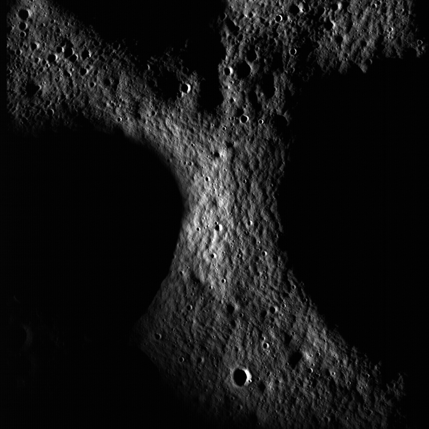
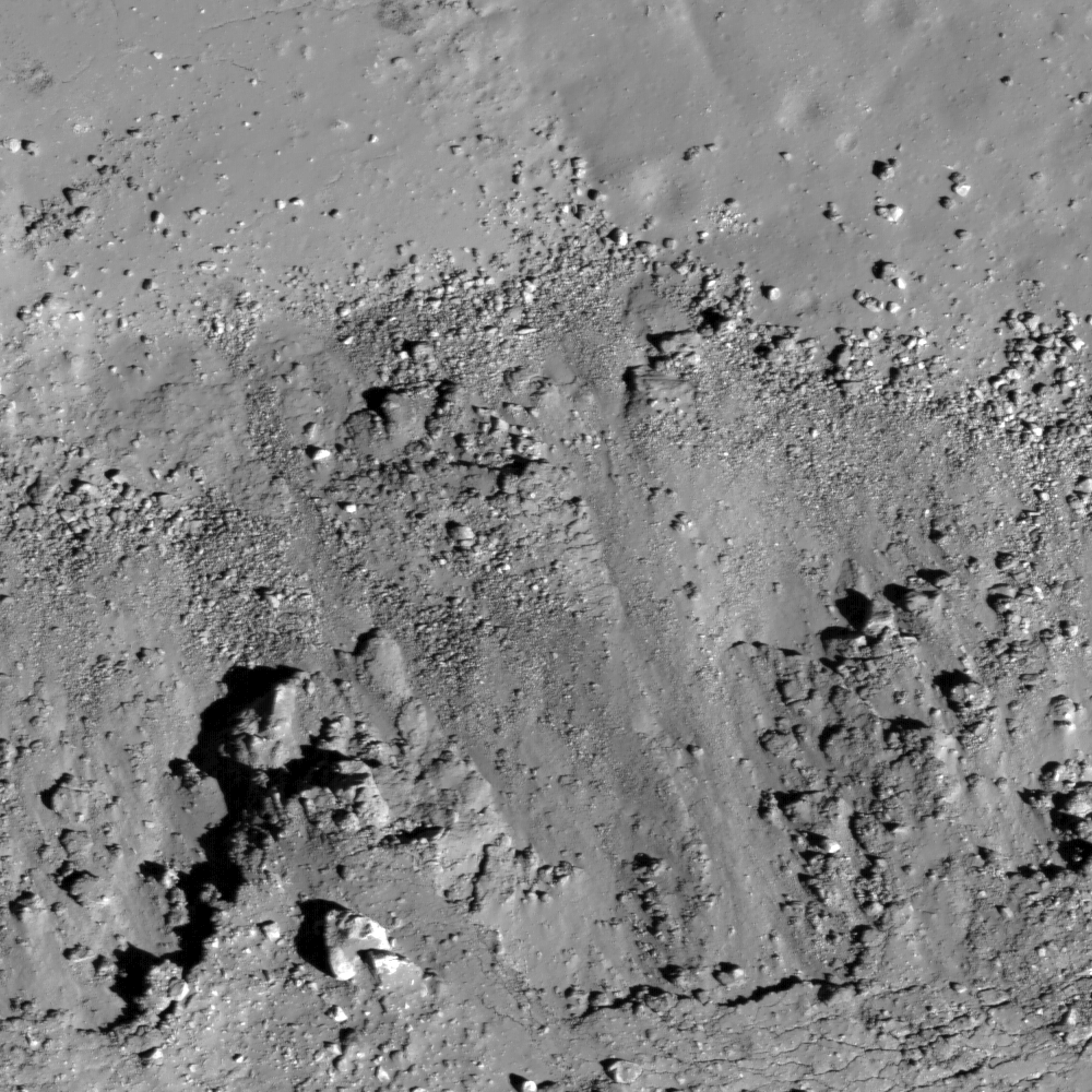
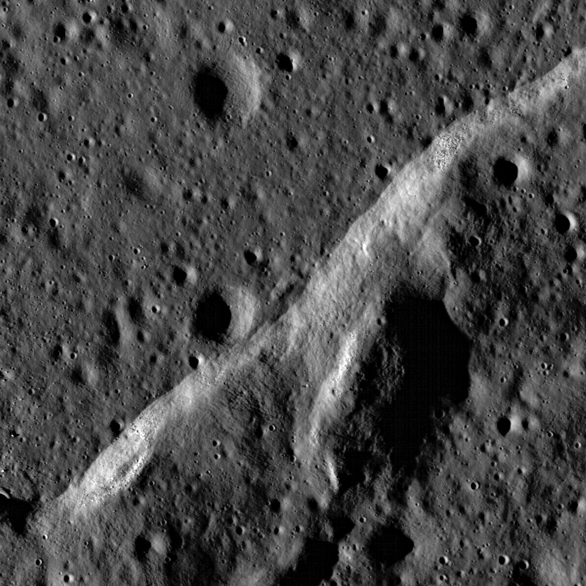
Boulders perched atop a wrinkle ridge in Mare Imbrium west of the Montes Teneriffe. Image width is 2 km, NAC frame M102264014RE [NASA/GSFC/Arizona State University].

Samuel Lawrence
LROC News System

Mare wrinkle ridge outlined by dramatic low Sun shadowing. Common in the lunar mare, wrinkle ridges are found in nearly all of the lunar maria, lunar scientists think that there is a genetic relationship between the basalts they deform and the ridges themselves. Basalt is much denser than the anorthositic crust on which the mare basalts are deposited. As the basalt fills in low areas in the crust, the increased weight causes sagging and the mare deposit is compressed, resulting in tectonic deformation in the form of wrinkle ridges.

Many LROC images show that boulders are often found on the top of ridges and other topographic highs. How did they get there? Were they tossed up and out by nearby impacts? To test this hypothesis look closely for small indents where the boulder hit and for possible source craters nearby. Alternatively they might be fragments of the ridge material broken off during deformation. Or were they on the surface before the ridge was formed? This unnamed ridge is found in the central northern Imbrium basin between Montes Recti and Montes Teneriffe Lat: 47.1°N, Long: 348.2°E.

Explore the whole NAC frame and see if you can determine the origin of the boulders!


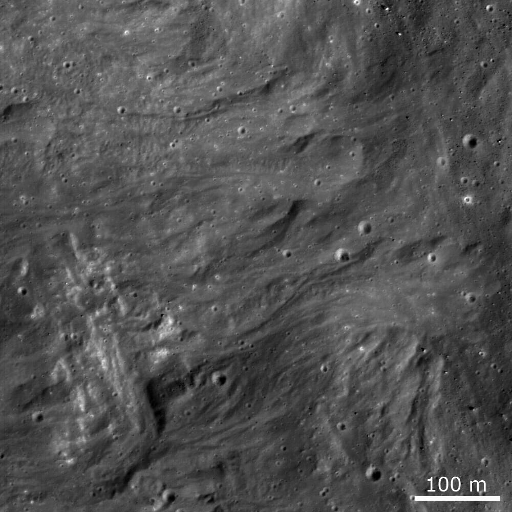
Powers of thousands. The yellow square roughs out the 1200 by 1200 px image reduced above, down to one-third its full-size. The full-size strip of the LRO Narrow Angle Camera image on the right is the right-hand twin of two images swept up at the same time, the 8.5 km-wide size as seen when first accessing the image through the LROC website, here. From there, the whole field of view can be examined in detail unseen since Cernan & Schmitt departed the surface in December 1972.

Tuesday, December 29, 2009

Big Ohm Boulder


In LRO's 336th orbit, still early during the commissioning phase, at 140 km in altitude (90 km higher than the present first year survey), LROC's Narrow Angle Camera took an excellent look at the complex interior of 64 km-km wide farside crater Ohm (246.5°E, 18.4°N). The structures of Ohm's interior reminds me of it's 20 percent larger, younger nearside sister Tycho, high intact walls with slumped terraced interior, very similar melt fill further in with a less distinct central peak. The 74 km long & 7.1 km wide stereo NAC strip is a rich cross section. Because it's central peak failed to coalesce as well as did Tycho's, on the rebound from what was likely a more oblique impact, Ohm's interior is filled with massive boulders, part of a mix of deep materials that may be part of the island crust that originally formed over the Moon's primeval magma ocean. The boulder above is among the most massive of the chunks, casting a over a quarter kilometer of shadow in the low sunset [NASA/GSFC/Arizona State University].

Like Tycho, Ohm has a respectable radiant ray system which would likely be quite distinctive if it's locus were visible from Earth. Its rays form the apex of a kind of chevron when seen in small scale from a great distance over the Moon's western hemisphere. Ohm's rays remind one more of those that formed when the progenitor of Proclus slammed into the western wall of Mare Crisium. Also likely to have been an oblique impact, the rays of Proclus spread east over Crisium in a fan whose sides projected north and southeast, less than 180 degress apart.


Heading North over the Far Side Japan's Kaguya took this full sun HDTV shot of Ohm in 2008. The bright sides of the north and eastward fan of the bulk of Ohm's rays system can be seen, along with the other differing aspects of Tycho's smaller and probably older sister. The central "peak" is more a system of parts of a peak. A comparison showing how the ray system of Ohm and Proclus are similar appears below [JAXA/NHK/SELENE].


There's a world of difference, literally, half a Moon apart, between Ohm (above) and the more familiar Proclus, the bright jewel of Crisium and the rugged Palis Somni and the sparkling marker of the young crescent Moons of Earthside evenings. Both impacts lose their distinctive shine when seen only in the context of blind topography. But in albedo, in this case as mapped by Clementine in 1994, each has left a mark more telling of their youth and optical immaturity, perhaps, then any permanent etching apparent to the human eye [NASA/DOD/USGS].

Saturday, December 26, 2009

Mare Orientale: Closing in for the Kiss


Mare Orientale, "the Eastern Sea" is on the far left or Western Limb of the Moon as seen from Earth after a Full Moon. To see why the Eastern Sea is viewed on the West take this opportunity to view the full-sized version of the image greatly reduced above. What you will see a world class, "amateur" but truly state-of-the-art video still mosaic of a late crescent Moon assembled by the guys Charles Wood calls "the Minsk miracle boys" in Belarus. They post their astounding work at Astrominsk.


When we move in on as much as this template will allow, on the actual size of the late Crescent Moon as seen in the Mosaic from Minsk, the flat Thumbnail Moon seen with a naked eye from Earth is now rich with detail, like pond water under a microscope. The foreshortened view around the curve of the lunar globe reveals fine structure. On the right in the frame above is Rima Sirsalis for example, bisecting the 32 kilometer-wide crater De Vico A. Distances are greater along our line of sight as our eye approaches the limb where the spectacular Mare Orientale basin straddles the borderline between the Moon's Near and Far sides, with much of its detail inside the libration zone. It is seen in profile as the Moon turns its head and back again, wobbling through the Near Side's tidal lock with Earth.


Ahead of the Moon in it's orbital path. If you left Earth orbit headed out toward the Moon like Apollo, on a "free-return trajectory," after 100 hours or so your initial velocity will have steadily slowed to a relative crawl by the time you approached the highest point of your ballistic path. If you timed the whole thing correctly this high point would correspond with a point somewhere ahead of the Moon in its orbit. As you wait for the Moon's gravity to increase your speed for a slingshot around its Far Side you would find yourself looking down at the Moon's "leading" Western Hemisphere. The cannon shot seen just below the Moon's equator is Mare Orientale, dividing the mostly basalt-filled lowland basins of the Near Side with the highland craters of the Far Side. Our target of interest is at the center of the circular smudge on the southwestern mountainous rings surrounding Orientale's central basin [Virtual Moon Atlas v.4].


More than forty years ago Lunar Orbiter IV captured the image above of the same Western Hemisphere, close to the time of a Full Moon down on Earth. Although our smudgy target is still awaiting sunrise, the long shadows of early dawn sketch out the rings and rooks surrounding the central basin with rich relief. The degree of the Moon's wobble brings the central basin and the rings and often the flooded lakes of the east side of the impact into view from Earth. Though broadly hinted to patient observers over centuries, the full extent of the basin's detail was not really known until photographs like this one became available. Unlike the more familiar Near Side seas, Orientale still has it's surrounding concentric mountainous ring structure still highly intact, hinting that the "impact forming event" that created it was either unusually energetic or more recent [IV-187-M USGS].


Efforts to map the widely varying elevations on the Moon reached a plateau with Clementine (1994), until the recent, far more dense dataset gathered using laser altimetry by Japan's Kaguya (which is only now being released) and the LOLA package on-board the Lunar Reconnaissance Orbiter sent by the United States became more available. Comparing apples with apples, the images above and below represent the same area on the Moon and the best improvements on the Clementine dataset available through the web-based Map-A-Planet service by the U.S. Geological Service. Above we can see what could not be easily understood using photography alone. Orientale's mountainous rings and rooks are largely intact but the basin's impact zone straddles more than just the Near and Far side longitudinally. It also lies along a distinct and global change in elevation, steadily moving toward the west and the rim of the massive South Pole Aitken Basin hundreds of kilometers outside our view on the left.


And in the second Map-A-Planet image our "smudge" on the southwestern side of mountain rings surrounding Orientale has become visible again. It appears to be mostly invisible to laser light at this scale (the map above and the color topography further up are each 900 km high and 1300 km from east to west). It is superficial, representing a change in optical reflectivity, maybe the remains of a plume, an eruption from it's center dusting the surface or changing its composition. This image come from the second improved version of a global albedo map produced using Clementine data collected in 1994. And we can see what appears to be a round feature, a crater near the center of the "smoke ring." For scale the basin at the center of Orientale is about 300 kilometers across. The smudgy smoke ring is 143 kilometers in diameter and the structure at it's center seems to be between 6.5 and 14 kilometers across.


A much closer look at the Clementine albedo map shows why it was less than clear what the diameter of the smoke ring's central feature might be. As late as the Apollo Era there was an serious debate over the origin of the Moon's intense cratering. Many clung to the idea that most of these had to be volcanic in origin. While the impact theory ultimately won the day that did not mean there were not volcanic vents on the Moon's surface. This one was described as "a kiss on Mare Orientale" in a census of these pyroclastic features in recent years. Traced out on the map are the respective lengths of two stereo photographs made of the area using the narrow angle camera (NAC) on-board the Lunar Reconnaissance Orbiter (LRO). The ovals designate the approximate location of LRO at the time each image was taken. The Moon revolves slowly under LRO's orbit, but it does revolve, eventually bringing the whole of the Moon's surface under the vehicle's survey. NAC Image M102795327 was taken during orbit 321 and M102802486 during orbit 322.


Flying northward from the south, Japan's lunar orbiter Kaguya took a fantastic High Definition Television sequence covering the length of the entire Orientale region. Passing to the port side of the orbit is our "Kiss." According to those who actually orbited the Moon, the Kaguya HDTV stills and sequences were very much as they remembered the appearance of the surface to have been looking out of the Apollo windows. Judging by the shadows this sequence from 2008 appears to have been taken under a full sun. The northern arc of the relatively dark, more "optically mature" smoke ring surrounding the oblong vent can would be visible to the naked eye at this distance [JAXA/NHK/SELENE].


Around the same time as the regional HDTV sequence or the Orientale Basin was taken, Kaguya took some equally fantastic looks downward along its orbit and gathered the Terrain Camera image of our "Kiss" vent. The image was taken as a comparison with images of the same feature using the orbiter's Multi-Band Imager. Here we see the surface albedo in a glory unsurpassed until barely a year later.


But this is the detail we are looking for, and it's easy to see why some have argued that the level of detail being downloaded from the LRO as we move into 2010 has made it difficult to understand without the kind context. very humbly presented here. Three images further up and you can see the length of the original image (LRO NAC M102802486 R), and one image further up allows the rubble along the rim of the pyroclastic "kiss" to be seen.

Above you can see that rubble at centimeter scales. The image is 800 lines of 52224 lines in height and 400 lines of 5064 samples across. The only better way to examine such detail is directly, sampling the rich database being tested for release next March and long before the first half of the LRO survey is complete.

Another better method of course would be to take a hike on the rim of the Kiss. Had someone been in the middle of that hike, stumbling over the boulders above, LRO would have easily caught their progress, along with each dusty foot print.

LRO is a necessary precursor mission before "extended human activity" on the Moon can begin, for the first time. As the dataset grows the results themselves show us why.

Friday, December 25, 2009

Industry experts outline Pan-Arab space agency

Abu Dhabi (Gulf News) Leading regional and international space industry experts gathered in Abu Dhabi earlier this month, for the region's leading space and satellite technology venue.

The second edition of the Global Space Technology Forum (GSTF) was officially inaugurated by Saudi Arabia's Prince Sultan Bin Salman Bin Abdul Aziz Al Saud, President of the Saudi Commission for Tourism and Antiquities.

The three day event December 7-9, at the Abu Dhabi National Exhibition Centre (ADNEC) came at an exciting time for the region's aerospace industries. It followed successful space activities in the United Arab Emirates (UAE) like the launch of DubaiSat-1, the UAE's first satellite and the announcement of major projects by Abu Dhabi-based companies Aabar Investments and 4C GEOC.

The conference opened with the keynote address by Prince Sultan, the first Arab, Muslim and royal to orbit Earth. Prince Sultan's speech covered the strategic role of space technology in the economic development of the Saudi Kingdom and the surrounding region.

In a session on space policy, regulation and economics Dr. Mohammad Argoun, former Director of the Egyptian Space Program, discussed economic and social benefits for the nations of the Middle East now embarking on space-based initiatives.

Argoun presented a detailed outline of the needed steps governments in the region should follow before creating a "Pan-Arab space agency."

"The larger dream is the creation of an Arab Space Agency, but critical elements of space industry capability must be in place first," Argoun said.

"We must develop a joint remote-sensing Arab satellite project first, and see the establishment of indigenous private sector space companies to form partnerships with international companies and push for greater development of the region's space industry.

"University support is also important, as it is gaining a foothold in component manufacturing activity and greater regional involvement in satellite design and assembly."

At the same session presentations were made by Mohammad Tarabzouni of the Space Research Institute at KACST, who discussed the important role space technology plays in disaster management and mitigation.

Ahmad Al Mansouri of the Emirates Institution for Advanced Science and Technology (EIAST) presented case studies of regionally-based space programs as models for developing public and private space initiatives.

The final session of the day focused on commercial opportunities related to space. Ramin Khadem, Chairman of Odyssey Moon Limited, gave an account of commercial Moon-focused endeavors and made the case for further exploration beyond geostationary orbit. Khadem explained early lunar missions by the former Soviet Union and the United States lacked "an economic agenda," and explored "less than one per cent of the moon's surface."

Recent plans for lunar exploration, by contrast, Khadem said, are designed to map and discover new areas of the moon.

Odyssey Moon, LTD has an official team competing for the Google Lunar X-Prize.

Thursday, December 24, 2009

Greetings from the Moon's North Pole


Junction between the rims of three craters on the floor of Peary crater near the lunar north pole is evident in this NAC image (M101955359L). Note the mottled texture of the regolith. Peary is a key exploration site for future astronauts due its proximity to potential resources. Image width is 2.68 km [NASA/GSFC/Arizona State University].

Brent Gerry
LROC News System

One day in the not-too-distant future, lunar explorers may spend their winter holidays at the lunar North Pole. Peary, an irregularly-shaped impact crater centered at 88.5°N, 30°E, could be the place to do just that. Adjacent to the lunar north pole, Peary has areas along its crater floor cast in permanent shadow, but it also has areas along its rim that may be permanently illuminated by the Sun. The proximity to the north pole, possible areas of permanent shadow and light, plus the potential for in-situ resources make Peary crater a challenging and enticing location for future human and robotic exploration. Peary crater is one of 50 specific sites being explored by lunar geologists using LROC images for NASA's Constellation Program.


Figure 1. Detail of the geologic map of the lunar north pole [Lucchitta, 1978]. Peary crater is located near the center of the image. Black arrows mark the portion of the crater floor illuminated in the full LROC frame. Download the full geologic map here.

The mottled texture visible in the regolith is relatively common on the Moon, especially in the lunar highlands. Known also as "elephant-skin" texture, it was first identified by lunar scientists analyzing Apollo-era photography during the 1970s. The geologic explanation for this globally-found texture at the present time remains ill-defined; one of the goals of the LROC science investigation is to shed additional light on the formation of this unique texture.

Explore the full LROC NAC frame.

Tidal forces may trigger earthquake swarms

Combined angles of stress on Earth from resonant events, such as a Full Moon at lunar perigee, etc., have a long and well-documented (and predictable) effect on Earth's ocean tides and upon certain behaviors seen among certain species of life on Earth. While long theorized as having a similar driving stress on Earth's dynamic lithosphere, perhaps even causing some earthquakes, these effects have been dismissed as too transitory and weak, even to "break the camel's back," as it were, by triggering earthquakes already set up to happen. Now a study has emerged bringing the idea's plausibility back to the forefront [DJ Jeffreys, UNLV 2003].

Matt Krupnick
The Seattle Times

Rumbles deep underground are caused by water being controlled by the sun and moon, University of California, Berkeley, seismologists concluded in a new study that could lead to a better understanding of earthquakes.

The study of a portion of the San Andreas fault revealed that underground fluids move like the tides, the scientists wrote in an article published Wednesday in the journal Nature.

Geologists had long wondered what caused the frequent rumbling 15 miles below the surface, said co-author Roland Burgmann, a Berkeley professor of earth and planetary science.

"People had looked for those kinds of relationships for decades," said Burgmann, who wrote the paper with seismologist Robert Nadeau and doctoral student Amanda Thomas. "Now, with these tremors, there's a very strong relationship."

Highly pressurized water essentially lubricates certain faults, including the San Andreas in California, far below the portion of the fault that causes measurable earthquakes, scientists found.

The relationship between the deep tremors and earthquakes remains unclear, Nadeau said.

Though scientists noted that a major 2002 Alaska earthquake set off deep tremors on other parts of the planet, it was not previously known the sun and moon could have a similar effect, said Kenneth Creager, a professor of earth sciences at the University of Washington.

"Seeing that (underground water) is sensitive to even smaller stresses is significant," he said.

Moon or Abstract Impressionism?


Seeing small areas of the Moon at 50 cm per pixel often presents unexpected views, and sometimes it is hard to interpret the geology at first glance, much less what is up and what is down! What are the white streaks? How did they get there? Image is 600 meters wide, from NAC frame M109624226L [NASA/GSFC/Arizona State University].

Mark Robinson

Principal Investigator
Lunar Reconnaissance Orbiter Camera (LROC)
Arizona State University

LROC News System


The white streamers are located on the west wall of a 6-km diameter unnamed crater lying near the center of the 42-km diameter crater Henry Frères (301.1°E, 23.5°S). The crater rim is to the west (left) and the floor to the right (east), thus downhill is to the right. The streamers are composed of blocky material, individual blocks are up to several meters in diameter, that slid down the crater wall towards the floor. Most of the material halted before it reached the crater floor.


Byrgius A ejecta (faint blue streak) crosses Henry Frères crater and the small crater highlighted here (image width ~200 km) - Black area in Byrgius A is an artifact in Clementine color data, not a real feature on the lunar surface [Clementine color image data courtesy USGS].


Did the blocky slides form when the crater formed--or later? If later, did the impact of ejecta from Byrgius A play a role by causing a moonquake or perhaps by even providing the blocky material? If these slides formed during the crater formation they must have been a very late-stage event, because they are so well-preserved. Geologists look at stratigraphy (what is on top) to determine such relations and reconstruct the sequence of events that formed the landscape both on the Earth and on the Moon.

Look for clues to the origin of these fascinating streaks in the whole NAC frame.

Tuesday, December 22, 2009

Bright Copernican Age crater


Subset of Lunar Reconnaissance Orbiter NAC image M112162602L showing landslides covering impact melt on the floor (see below) of a fresh unnamed Copernican-Age crater beyond the western edge of Oceanus Procellarum and Balboa. Image width 220 meters (0.55 m/p) [NASA/GSFC/Arizona State University].

Samuel Lawrence
LROC News System

A key part of the LROC science investigation is the imaging and analysis of fresh Copernican Age craters like this small (6-km diameter) example at the edge of Oceanus Procellarum, west of Balboa crater. The LROC team has seen a variety of landforms related to these important lunar features. For example, a landslide on the crater wall partially covers the solidified impact melts on the floor. The landslide clearly happened after the crater initially formed so materials were likely dislodged by seismic shaking from nearby smaller impacts.

These young, fresh craters preserve a vital record of the impact process.

Where does ejecta come from? How much impact melt is produced? How thick is ejecta? What is the importance of self-secondary impacts? These are only some of the important scientific questions lunar scientists can address studying these craters.

As geologic time progresses, the pristine features in fresh craters are worn down by impacts of all sizes. Understanding young craters helps geologists piece together the history of far more ancient and degraded craters, an understanding particularly useful for planning future human missions to the Moon. The best way to explore fresh craters like this one, of course, would be with astronauts on the surface. Until humans return to the Moon, however, lunar geologists will analyze images like this for clues, as well as comparing landforms like the one visible here with other craters on the Moon, Mars and Earth.

Explore this crater yourself in the whole NAC image.


On the Moon, no one can hear your strike


Or if you make a "Lunar Hole-In-One." Among the informal prerelease of more than 700 LRO Narrow-Angle Camera images to the Planetary Data System are a number of strategic sweeps of Mare Orientale. Near the center of M102788040 (Orbit 320) a large boulder appears to have been dislodged with unknown force and then rolled down the grade before shattering into a secondary crater. It's fragments emerged outside the opposite rim [NASA/GSFC/Arizona State University].

Lunar Orbiter Mosaic, USGS Map-A-Planet

Monday, December 21, 2009

Inertia curves a Far Side boulder uphill?


Looking through the images and data released to the Planetary Data Systemas part of an informal test by the Lunar Reconnaissance Orbiter Camera (LROC) team at Arizona State University, we poured over a rich boulder landslide field near 233.93°E, 24.46°S, or approximately 100 kilometers west by southwest of the Gerasimovich Swirl. We almost missed it, but our eyes were eventually drawn deep into the long shadows before sunset under LRO Orbit 347. Among many boulder trails we seem to have found one that's a little different. A rather sizable boulder appears to have rolled first downhill, as part of a larger chunk of debris. Part of it seems to actually have rebounded briefly and curved on a terrace back uphill. It then seems to have become lodged into the grade and then afterward become dislodged again, tipping forward where now rests [NASA/GSFC/Arizona State University].

Sunday, December 20, 2009

Mysterious Mees

A small (~6.9 kilometer square) section of the Mees Formation, attendant to Mees (~263.72°E, 16.71°N) and, at least at one point, a 1,645 meter deep crack in the highlands well to the north by northwest of Mare Orientale. It is also just barely in the libration zone that allows it be visible from Earth, albeit at a very steep angle. By all appearances it's a basin, a long lake instead of a basalt-flooded "Sea." Some evidence has been put forth that the relatively late impact that created Orientale was sufficient to cause the eruption of lava at places several times as far away from the impact, and the length of Mees is radiant from the spectacular Orientale impact zone. The area was not well surveyed forty years ago. LRO is plugging the gaps in our knowledge of the Moon in several dimensions.

LDAP 2010 - Conference Program Online

Mihaly Horányi
Laboratory for Atmospheric and Space Physics
Department of Physics
University of Colorado at Boulder

The first workshop on "Lunar dust, plasma and atmosphere: The next steps" will be held January 27 – 29, 2010 at the Laboratory for Atmospheric and Space Physics, University of Colorado, Boulder, USA.

The meeting will be a forum to discuss our current understanding of the lunar surface and atmosphere, and share results from past and still ongoing missions. It will focus on the open science questions, the status of our modeling and laboratory experimental capabilities, required measurements, and instrument capabilities for future investigations on orbit, or to be deployed on the lunar surface.

The meeting will include both invited and contributed talks, and will maintain a true workshop atmosphere to foster discussions. The conference proceedings will be published in a special section of the Journal of Geophysical Research – Space Research.

Program now available, HERE.
-------

Another angle on Hermite, near the lunar North Pole, revealed this past week by David A. Paige, Principal Investigator for the LRO Diviner experiment as the location of the coldest known permanently shadowed regions on the Moon, cold enough to freeze nitrogen and easily the coldest place this side of the Kuiper Belt [NASA/JPL/UCLA].

Ares I not dead yet...

Ian O'Neill
AstroEngine

You may be forgiven for thinking that President Obama had decided on the future of NASA’s human spaceflight plans yesterday, but in an official (note: official) statement from the White House today, Obama says that he has made no such decision.

In a nutshell, NASA would get an additional $1 billion in funding and start work on a new (yet undetermined) heavy-lift launch system. Good news for NASA, but not-so-good news for the Ares I (and possibly Ares V, although the larger rocket wasn’t mentioned). Also, this magical silver bullet of a “new” launch vehicle would be ready for blast-off in 2018.

Read the Skinny, HERE.

Far Side Delights

Moon Sheep. Huge boulders seem to have been herded together on the rim of a small and very weathered crater near the northeastern rim of Far Side Hertzsprung basin, south of a line stretched between craters Weyl and Fersman. It's a small far-flung corner in one of 786 images released to the Planetary Data System (PDS) on Friday. Part of an informal test by the Lunar Reconnaissance Orbiter Camera (LROC) team that includes data from images taken during the commissioning of the Narrow-Angle Camera (NAC) survey, Orbits 318 - 354 [NASA/GSFC/Arizona State University].


Square Peg - Another small corner from one of two images among the raw 786 LROC PDS test shots that is unambiguously taken from the deep interior of Mare Orientale. This one, from Orbit 318, is of the chaotic transition between the huge volume of slumped landslide material from the interior basin walls and the basalt-filled middle interior; very near the western side of Hohmann (~264.82E°-17.65°S; Sunrise to the left, f=74.3°) [NASA/GSFC/Arizona State University].


Little House on the Prairie? (Not) - It's the anomalies that catch the eye on first glance. Since the Sun was from the right (f=72.29°) when LRO's NAC shot sequence M102951844R not far from Comstock and well on the Moon's Far Side (~239°E, 20°N) the odd feature is concave rather than convex, indicating an ancient slump of upper material collapsing into a fault of indeterminate scope and origin [NASA/GSFC/Arizona State University].

Saturday, December 19, 2009

LROC tests the PDS with a pre-release


It's only a Sample of a Sample, but we couldn't post nothing, even though it's very early in our investigation of the outstanding Christmas present Friday from Mark Robinson and the LROC team at Arizona State University. It's a treasure of 700 recent LRO Narrow Angle Camera (NAC) images, released as a welcome test of LRO's eventual relationship with the Planetary Data System (PDS). As to the sample above, after examining the rich, comma-delimited index of the 786 images released to the PDS, the terrain appears to have been along the southern outer ring of Mare Orientale, near 265°E, 37°S [NASA/GSFC/Arizona State University]

Mark Robinson
LROC News System

LRO NAC Image Pre-release

The first Planetary Data System (PDS) LRO data release will occur in mid-March 2010. To help interested users familiarize themselves with LROC data before the official release date, the LROC team will periodically and "informally" release a selection of PDS Experiment Data Records (EDRs).

Drafts of the PDS Software Data Product SIS and Archive Volume SIS will also be released to help users understand the data. Please keep in mind that the labels and/or SIS documents may be updated before the official release next March. The directory structure mimics that of the final release including reduced resolution browse images, histograms, and other ancillary information.

Over 700 NAC frames in PDS EDR format are now available for download:

http://lroc.sese.asu.edu/data/LRO-L-LROC-2-EDR-PRERELEASE/COM/
http://lroc.sese.asu.edu/data/LRO-L-LROC-2-EDR-PRERELEASE/EXTRAS/BROWSE
http://lroc.sese.asu.edu/data/LRO-L-LROC-2-EDR-PRERELEASE/EXTRAS/HISTOGRAM

PDS Software Data Product SIS

PDS Archive Volume SIS

CSV file with image support information

Friday, December 18, 2009

Really, Really Close-Up on the Alpine Valley


Just how old is the incredible Vallis Alpes, the "Alpine Valley" bisecting the Montes Alps on the northeast "rim" of Mare Imbrium? Through a telescope the valley appears to be a crack radiant from the Imbrium impact (~3.8 billion years). Among other clues the arc of mountains it transects seems out of "sync" with where the eye traces out an apparent circumference for Mare Imbrium. Lunar Orbiter IV obtained excellent shots of the area, and in 2008, Japan's space agency JAXA released a 3D Grand Tour "fly-over" of the valley from data obtained by Kaguya. And last summer, soon after LRO arrived in lunar orbit, its narrow-angle camera (NAC) under the direction of Mark Robinson's LROC team at Arizona State University, LRO flew over the "mouth" of the valley, crossing where its inner channel seems almost to briefly run uphill, over the highest hills along its 134 km length [JAXA/SELENE].


LRO is in a polar orbit, of course, but Vallis Alpes runs southwest to northeast (or vice versa). LRO crossed the valley very much as diagrammed in the Kaguya Terrain Camera image up above. It was necessary to back away a bit to get the entire 8.5 kilometer strip from orbit 562 inside the constraints of this blog's template. Along the whole of the valley's length a sinuous rille meanders through its middle plain. At this location, however, the wider valley has narrowed to a "bottleneck," and the channel continues through the higher mountains not far from the edge of Mare Imbrium [NASA/GSFC/ASU].


Closing in on the bottle neck, using Arizona State University's "Zoomify" Image Browser (which also hosts Apollo's orbital metric and panorama photography), and what is easily the best image ever of Vallis Alpes inner channel comes into view. An island can be seen where the channel of molten material changed course long ago, and strong hints are seen of the channel's true age. "Elephant Skin" mottling, typical of highland hills throughout the Moon, traces down along a hillside that long ago collapsed or weathered down into the channel, burying its north rim [NASA/GSFC/ASU].


As close as it gets thus far in LRO's mission and the east side of the "island" seems to sit in a gently flowing river on Earth, complete with "river gravel." The image is perhaps a kilometer wide at this scale, however, and its depth is ~1.6 meters per pixel, so those stones are really boulders. The landscape presents another mystery, too. Where are the intermediate-sized and secondary craters? The Moon's surface, it is thought, is superficially "gardened" every two million years or so. Is this terrain telling us of Moonquakes and relatively recent landslides?

"A bottleneck at the start of the lunar sinuous rille within Vallis Alpes formed several morphologic features including (from left to right) a lava pond, a breached dam, and an island in the rille." [NASA/GSFC/Arizona State University].

Brent Garry
LROC News System

"Vallis Alpes (Alpine Valley) is a spectacular linear valley along the northeastern edge of the Imbrium impact basin. It is easily visible in amateur telescopes. The floor of the valley was flooded by mare basalts that host a sinuous rille which stretches for more than 150 km. High-resolution NAC images reveal small features that not previously resolved in the existing Lunar Orbiter frames; including an "island" within the rille, a breached dam, and a remnant lava pond. Based on the available data, there are some outstanding geologic questions about this rille that will be addressed by future human exploration. For instance, where is the source for the lavas in the middle of the ejecta blanket? Are these lavas older, younger, or related to lavas in Mare Imbrium and Mare Frigoris? Did a fault or graben create the long valley now occupied by frozen lava? Was the valley formed as a result of the Imbrium impact event or is it younger? For now NAC images, combined with previous maps and data sets allow scientists to make observations of the rille's morphology and stratigraphic relationships between the different units to piece together the geologic history of this rille and the surrounding region."

View the full discussion, the images and diagrams,
at LROC's website
HERE.

Thursday, December 17, 2009

Lunar morphology in the Lake of Death


Close up on southwestern Lacus Mortis and a 700 meter wide section of 104 km-long graben Rimae Burg near where it translates from the mare-filled "lake" into the highlands beyond its shore. The narrow angle camera on-board LRO swept up this familiar Near Side telescopic target early in the commissioning phase of its mission during orbit 211, July 12, 2009 - [native res 1.6 m - NASA/GSFC/Arizona State University].

Mark Robinson
LROC News System

"Graben are extensional tectonic features in which a crustal block was down dropped between a pair of faults ("normal faults") when rock is pulled apart (tension). Normal-fault surfaces usually dip about 60 degrees, so the original fault scarp would have been steep as well. Over time, micrometeorite bombardment of the lunar surface results in a gardening of the regolith and the steep slopes become eroded to what is observed here. How does crust "pull-apart"? On the Earth, geologists often see pull-apart features in regions where plate motions are in opposite directions resulting in tension - a zone of parallel faults occurs and grabens form. Lunar scientists have found no evidence of plate tectonics on the Moon--the Moon is a one-plate planet. Tension zones on the Moon are usually found on the outer margins of mare basalt deposits. The mare have a relatively high density, weighing down the crust. As the crust sags beneath the mare, rocks in the central portions are put under compression, sometimes resulting in wrinkle ridges, and rocks at the margins are pulled apart resulting in grabens. The story is sometimes more complicated in areas where there are multiple large deposits. This particular graben, Rima Burg, cuts Lacus Mortis (Lake of Death) and extends into the adjacent highlands. Inspecting a lunar map shows that the local stresses in the crust may come from Frigoris or Serenitatis. Alsograben may follow pre-existing deep fractures in the crust from the formation of large basins. One of the many tasks for future lunar explorers is to inspect tectonic features and work out the complicated tectonic history of the Moon.

"Browse the whole NAC image and examine this graben for yourself."


Context (above and below) for this latest release from the LROC team at Arizona State University provided by Lunar Orbiter IV.


What Happened on Impact Night?

Paul D. Tompkins
LCROSS Flight Directors Blog
"The LCROSS mission was ultimately focused on the final four minutes of flight, starting at the time of the Centaur impact, and ending with the impact of the Shepherding Spacecraft. During that time, the Payload Engineer and the Science Team took operational center stage. Once the science payload was powered on, the team’s job was to confirm the full functionality of the instruments, and then to adjust instrument settings to make sure the data we received was the best it could possibly be. For Impact, there were no second chances – the Shepherding Spacecraft was to be destroyed as a forgone outcome of its observation of the Centaur lunar collision."
Read the latest Post HERE.

Wednesday, December 16, 2009

Coldest Spot on the Moon


Hermite is foreground for an Earthrise in 2007, witnessed by Japan's Kaguya. Hugging the west side of the Moon's north polar region Hermite is within the Zone of Librations. Though two-thirds of its 114 km-wide interior is technically on the Moon's Far Side it can still be seen from Earth. Not along its southwestern interior, however, in perpetual shadow and where LRO's Diviner has measured the Moon's coldest surface temperatures, temperatures as cold as any now known this side of the Kuiper Belt [JAXA/NHK/SELENE].

Diviner News - The Diviner lunar radiometer has been mapping the temperature of the Moon since July, 2009. During this period, temperatures in the lunar polar regions have changed gradually as the lunar seasons have evolved. The tilt of the moon’s spin axis is only 1.54 degrees and as a consequence, lunar seasons are barely noticeable in most locations on the Moon. However, at the north and south poles, the height of the sun above the horizon varies by more than 3 degrees over the course of the year. This affects the percentage of sunlit regions and surface temperatures at the poles.

During October, 2009, Diviner observed the passage of summer solstice in the southern hemisphere and winter solstice in the northern hemisphere. The LRO launch date was chosen so that its orbital plane passed through the noon to midnight plane in October, allowing Diviner to measure the extremes of polar temperatures. Figure 1 illustrates the configuration of the LRO orbit and the lunar seasons.


Figure 1.
The configuration of the LRO orbit during October 2009 allowed Diviner to measure maximum temperatures near summer solstice in the south polar region, and minimum temperatures near winter solstice in the north polar region. (NASA/GSFC/UCLA)


Figure 2. (BELOW) shows a Diviner Channel 8 thermal image of the south polar region acquired between October 3-30, 2009. The mapping period overlaps with the LCROSS impact on October 9, 2009. Figure 3 shows an annotated version of the image, including the location of the LCROSS impact. The rugged south polar topography makes it one of the most picturesque regions on the planet. Diviner’s thermal measurements allow us to “see” both the warm sunlit and cold shadowed regions in striking clarity and detail. Even at their warmest, the permanently shadowed areas in the south polar region are extremely cold. The coldest areas are located in doubly shadowed regions inside small craters that themselves lie within the permanently shadowed regions of larger craters. Diviner measured minimum channel 9 brightness temperatures as low as 35K (-238C or -397F) in these areas, even at noon on the warmest day of the year.


Read the Diviner News Release HERE.


On the opposite side of the planet, Diviner mapped the north polar region at winter solstice. Figure 4 from Diviner's news release (December 15, 2009) shows a nighttime false-color channel 9 map of the region that reveals the presence of areas with temperatures as low as 25K (-258C or -415F). The coldest spot on the Moon that Diviner has detected thus far is located on the south western edge of the floor of Hermite Crater. There are also regions on the southern edges of the floors of Peary and Bosch Craters that are almost as cold. To put these cold temperatures in perspective, one would have to travel to a distance well beyond the Kuiper belt to find objects with surfaces this cold. Diviner measures the temperature of the top millimeter of the lunar surface. We would expect temperatures below the surface to be warmer due to heat retention from the spring and summer seasons.

Young Giordano Bruno


Frozen impact melt flows on the ejecta blanket of the young impact crater Giordano Bruno (22 km diameter). The image is about 600 m across and the flows are about 50-100 m wide (NASA/GSFC/Arizona State University).

Mark Robinson
LROC News System

In many cases LROC has seen frozen flows of impact melt inside and on the flanks of Copernican aged craters. Giordano Bruno is one of the youngest large craters (22 km diameter) on the Moon. How old is "youngest"? Written accounts of twelfth century eyewitness reports of a bright flash on the Moon may record the event that formed Giordano Bruno crater. That idea was proposed after the first high resolution pictures of the crater were analyzed from the Apollo era of lunar exploration. Scientists could see that the crater was very young and was in the area of the Moon corresponding to the bright flash, so it seemed possible that the flash and crater were related. More recently a team of scientists analyzing high resolution images acquired by the Japanese lunar orbiter Kaguya estimated that the crater formed more than one million years ago. Very young by lunar standards, but certainly not consistent with the eyewitness reports. The Kaguya team (see below) determined the age by counting the number of craters that formed on the Giordano Bruno subsequent to its formation. Were some of the small impacts discovered on the crater actually formed as late stage ejecta rained down on the crater? If so the age may be younger than the current estimate.

The very high resolution images being returned by LROC are revealing impact crater features in exquisite detail. The deposits shown above are actually small distributary flows that emanated from a larger mass of impact melt that was thrown out onto the northwest rim by the impact. Although formed by a different process, impact melts flow in much the same way as lava flows, forming lobes and exhibiting channels and levees. Like lava flows, they cease to move when their source is depleted or the melt cools and freezes into solid rock. Impact melt is formed by the heat and pressure of the impact process. This particular area is at 36.34°N, 102.45°E. The scene is about 600 m across; image resolution is 0.6 m/pixel.

Hopefully, soon the true age of Giordano Bruno can be determined by radiometric age dating of impact melt rocks returned by future astronauts. In the meantime scroll around in the full image and see if you can determine how the small impact craters formed on this fascinating young crater.


(BELOW: Giordano Bruno from Kaguya in 2007 and 2008.
)