Showing posts with label Hertzsprung. Show all posts

Thursday, June 12, 2014

Study in superpositioning at Vavilov D

Sunrise, sunset. LROC NAC observations 10 months apart, one at local sunset and the other after local sunrise, both from nearly identical altitudes and resolutions, capture these views of double "dingleberries," drops of hot melt, very likely from the impact that created Vavilov crater, sit where they quickly flattened and cooled, just inside the steep slope of ancient Vavilov D. The Vavilov craters are a study in stratigraphy and superposition [NASA/GSFC/Arizona State University].
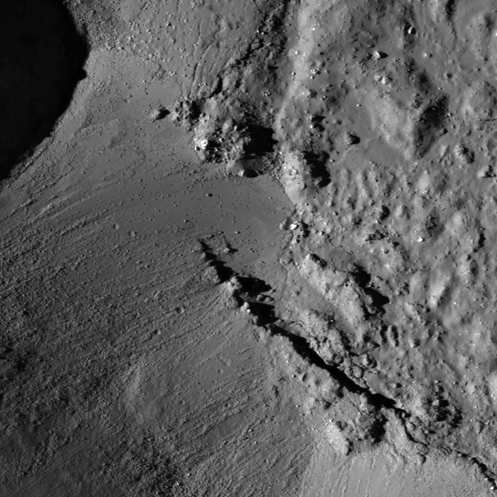
Immediately inside the northwest rim of highly degraded Vavilov D, twin disks of impact melt, likely from the formation of Vavilov, came to a standstill at the upper end of a contiguous slope of 5000 meters elevation, over about 40 km, into the complex floor of the latter Eratosthenian crater. This 1400 meter field of view (down slope is to the lower right, centered on 1.14°N, 221.536°E) from LROC NAC observation M1128031686L, LRO orbit 18385, July 9, 2013; 61° incidence angle, resolution 1.17 meters from 114.6 km [NASA/GSFC/Arizona State University]. 
Hiroyuki Sato
LROC News System

Vavilov D is an heavily degraded crater (96.1 km; 0.026°N, 220.93°E) sits between the Orientale basin and Jackson crater, both of which it may pre-date.

The later formation of the nearly identical, over-lapping Vavilov crater (98.2 km; 0.87°S, 221.23°E) eradicated the entire southwestern half of Vavilov D.

The second image above spotlights a spot on the northwestern curve of the wall of Vavilov D near where the Eratosthenian Vavilov erased the older crater's anatomy. The relatively smooth textured area in the upper left corresponds to the outside of Vavilov D, and the rest of rough/craggy surface is the interior crater wall's steep slope. 

The two degraded craters (~280 m in diameter) near the middle of the opening image exhibit fascinating overlying smooth features that may have formed as material flowed downslope (arrows).

View the full-resolution original HERE. The twin melt disks are located where the rim of Vavilov superseded that of Vavilov D, in the farside equatorial highlands,  where Vavilov is etched into terrain 8000 meters above the global mean elevation. It's possible an astronaut could walk from this location south into the interior of Vavilov. 5.6 km-wide field of view from LROC NAC observation M1128031686L [NASA/GSFC/Arizona State University].
Other morphologic pits/dents on this slope also have similar textures. What we are seeing here are most likely remnant impact melt that was thrown out of the Vavilov crater. Craggy sloped surfaces with patches of smooth material are often found associated with young impact craters -- formed as impact melt flowed over and around the newly formed crater.

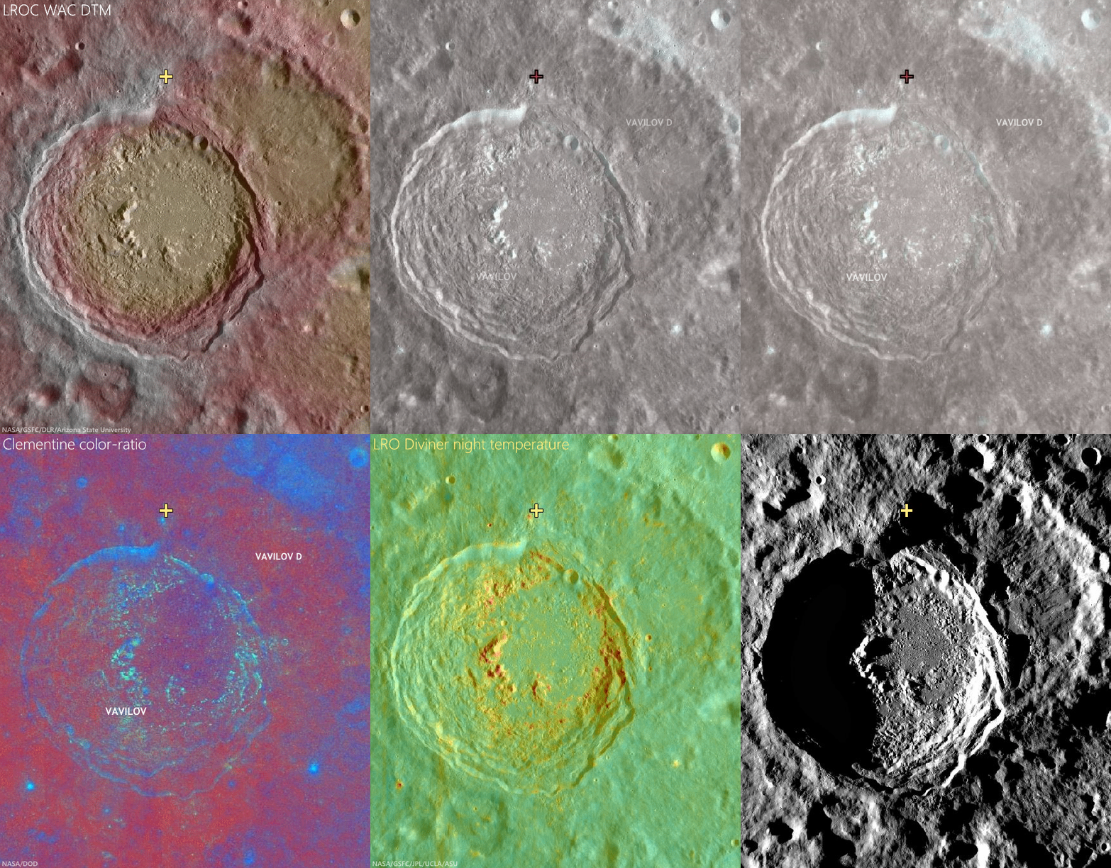
The deepest material brought to the surface by impacts on the Moon is found on the resulting crater's rim. A fresh crater near our area of interest, on the rim of Vavilov D (cross), exposes material excavated by that ancient impact, and Vavilov D, in turn, is nested on the Hertzsprung basin. The larger region is also at the outside range of the majority of secondary craters from the Orientale basin-forming impact. LROC Quickmap mosaic [NASA/GSFC/Arizona State University].
Depth of field in lunar photography is a fleeting quality. With the LROC WAC-derived elevation model (GLD100), however, the super-positioning of Vavilov D (and an aeon or two later, Vavilov) on Hertzsprung is much easier to detect, along with some of the most extreme elevation ranges, some 9 km above the global mean [NASA/GSFC/DLR/Arizona State University].
Related Posts:

Thursday, August 29, 2013

Rough crater wall surface

M182038126L_thumb-580x1000
Upper part wall inside an unnamed fresh crater in the southwestern quadrant of farside Hertzsprung basin. LROC Narrow Angle Camera (NAC) observation M182038126L, LRO orbit 11934, January 24, 2012; 56.41° angle of incidence, resolution 1.08 meters per pixel from 107.13 km. Downslope is toward lower right, north is to the top [NASA/GSFC/Arizona State University].
Hiroyuki Sato
LROC News System

The opening image reveals the northwestern portion of the steep wall inside an unnamed young crater (6.8 km in diameter, the same crater in Tuesday's Featured Image). The upper left corner of this image, the relatively smooth part, corresponds to the outer gently sloping surface, and the rest of the image is the interior wall.

This steep surface displays very complicated forms, likely due original flow of impact melt down the walls, perhaps in places modified by small scale collapses. Several spots indicated with arrows show the contact between relatively smooth surface materials, probably impact melts, and sharp craggy edges. Are the smooth parts really impact melt? Or perhaps they are surfaces from which hardened impact melt slipped down. What we do know is that enormous amounts of impact melt were splashed around inside and outside the crater, a violent scene we can hardly imagine. New LROC data is unveiling the nature of impact melts through their shape, texture, distribution, quantity, and spectral reflectance.

LROC WAC M112461899C (604nm) 580x1000
The unnamed crater and surrounding areas in the LROC Wide Angle Camera (WAC) monochrome (604nm) observation M112461899C, spacecraft orbit 1707, November 10, 2009; 39.1° angle of incidence, resolution 86.97 meters per pixel, from 61.69 km over 7.25°S, 227.53°E [NASA/GSFC/Arizona State University].
Explore this fresh and complicated crater wall in full NAC frame, HERE.

Related Posts:
Sinuous Cracks
View From The Other Side
Craggy Peak, Impact Melts
Cracked mound
Waves
Tycho Central Peak Spectacular!

Tuesday, August 27, 2013

Debris over impact melt pool

M182038126R_thumb-580
Debris avalanche covering an impact melt pond inside an unnamed crater floor. From LROC Narrow Angle Camera (NAC) M182038126R, LRO orbit 11934, January 24, 2012, centered on 4.135°S, 227.677°E, angle of incidence 56.58° over a field of view 1083 meters across, resolution 1.08 meters from 107.13 km. Downslope is toward upper right, north is to the top [NASA/GSFC/Arizona State University].
Hiroyuki Sato
LROC News System

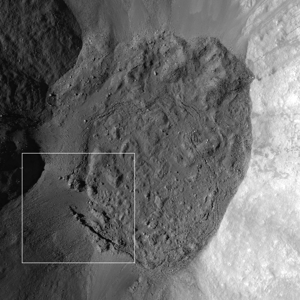
Today's Featured Image highlights the southwestern edge of the floor of an unnamed crater (6.8 km in diameter), located in the SW corner of the degraded Hertzsprung basin (540 km diameter). The rough hummocky surface (upper right) corresponds to an impact melt pond, which covers the floor of this crater. The debris avalanches originated from the crater wall and covered the melt pond surface in the lower left. These debris deposits follow the topographic gap along a fracture extending to the lower right from the center of this image, indicating that the fracture formed before the avalanche.

M182038126R_NAC_context-600
The NAC frame as context for the LROC Featured Image (frame), showing the unnamed crater floor in Hertzsprung basin within a 3 km field of view [NASA/GSFC/Arizona State University].
Impact melt ponds usually develop fractures and deformations of their surfaces (e.g. Melt and more melt, Channels And Fractures). The cause and timescale of such modification is unclear and still under discussion (e.g. Ashley et al., 2012) but is likely due to the crater subsurface re-adjusting as the impact melt cooled and hardened. The shape of impact craters slowly evolves over long periods of time. Thanks to the relatively slow erosional processes on the Moon relative to the Earth, we can observe a series of craters from young to very old with NAC images, helping scientists understand the process of crater formation and subsequent modification. 

M182038126R_context-580x599
The unnamed crater and surrounding area in LROC Wide Angle Camera (WAC) monochrome mosaic (100 meter LROC Global Mosaic), centered on 4.02°S, 227.72°E. The NAC frame footprint and the location of Featured field of view are designated [NASA/GSFC/Arizona State University].
Explore the debris avalanche inside this young fresh crater in full NAC frame, HERE.

Related Posts:
More Impact Melt!
The View Inside of a Tilted Crater
Schiaparelli E
Channels And Fractures
Impact melt outside Wiener F
Rippled Pond
Melt and more melt
Vavilov-Hartzsprung-LROCDEMCSHd-064-969
Color shaded LROC digital elevation model shows the small crater in starker contrast not readily visible in pure optical photography (arrow, right of lower center), in the ancient Hertzsprung basin and nearby Vavilov crater. 400 km field of view, orthographic projection from LROC WMS image search map [NASA/GSFC/Arizona State University].

Tuesday, January 31, 2012

View from Vavilov

Vavilov (0.8°S, 138.8°W), the 'relatively recent' 98 km crater straddles a crossroads in the violent timeline of the Moon's history and sports some of the Moon's highest elevations on the northern and western rim. Interestingly, Vavilov formed nearly on top of a similarly sized and much older crater whose rim is still visible as a semicircle immediately northeast. Both craters carved out the same unique notch in the west wall of Hertzsprung impact basin. Image from 160 kilometer wide field of view cropped from a LROC Wide Angle Camera monochrome (566 nm) mosaic stitched from eight June 3, 2010 orbital viewing opportunities averaging 76 meters per pixel with an incidence angle of 64.5° from 55 km altitude [NASA/GSFC/Arizona State University].
WAC-derived elevation model (GLD100) Scene elevation (meters)
minimum = 2131.00, maximum = 9317.00 NASA/GSFC/Arizona State
University].
The elevation models of the Moon, built up during the record-breaking first 10,000 orbits by the Lunar Reconnaissance Orbiter (LRO), are finally allowing us to see the lunar surface in definitive detail. Naturally, this is especially true of the farside, invisible from Earth, and the polar regions. Even the vast highlands of the farside, unseen before 1959, have either been imaged at very wide angles or at low angle in part.

The Lunar Reconnaissance Orbiter Camera (LROC) in particular has been a spectacular success at imaging nearly half the Moon's surface at very high resolution and in surveying the entire Moon under a wide range of lighting conditions. One result is a highly accurate digital terrain model that just keeps getting better.

A weak attempt to represent a 100 degree wide panorama of the Vavilov interior and southern rim from its highest elevations situated along that crater's north rim. For the first time LROC is allowing us to imagine what that view might be, but it still does such a scene little justice to squeeze it into a 580 pixel-wide image [NASA/GSFC/ILIADS/Arizona State University].
Until LRO, many, but not all, of the wide angle views of the lunar farside have been focused on low resolution wavelength analysis, albedo, mineral and some low light relief. And even millions of laser altimetry measurements haven't matched the number of points recorded by LOLA during the LRO's present mission, already in lunar orbit far longer than any previous spacecraft. The record of the location of places photographed and measured hasn't been helped by the simple fact that no one really knew the Moon's actual shape and size with a high accuracy until Japan's Kaguya (SELENE-1) mission.

The Moon's highest elevations (10,761 meters) are now believed to be more than 600 km northwest of Vavilov, on the rounded wide rim of the crater Engel'gardt, but as we round the Moon's western rim, past Oceanus Procellarum and north of Mare Orientale where the farside highlands begin, and continue to proceed westward along the Moon equator the first very highest elevations encountered are on the north and western rim of Vavilov.

Easily among the highest elevations east of Engle'gardt East is on the upper reaches of the slumping wide north wall of Vavilov. We can only guess whether those heights could have once been much higher. The chaotic terraces of the western interior of Vavilov testify to a high degree of slumping, massive landslides underway since the crater formed. LROC WAC observation M130205287C (566 nm), orbit 4321, June 3, 2003; incidence 64.67° with a resolution of 77.11 meters per pixel, from an altitude of 55.31 km [NASA/GSFC/Arizona State University].
That Vavilov is deeply notched into the west-southwestern wall of the vast Hertzsprung impact basin is not something one can easily tell from Clementine (1994) albedo imagery, for example. So many craters with extended ray systems, like Jackson, overlap over the farside highlands, already bright for their relative lack of the mare-filled basins that dominate the nearside, that getting a gauge on elevations has remained elusive until the LRO mission. With the human eye alone its nearly impossible. But there is a reason why Vavilov is different, and higher, in one half than the other.

The west-southwest of Vavilov is not as stark a contrast in elevations as its north wall but the elevations are still respectable. The highest point along that rim is 9317 meters, among the Moon's highest places, and the high ejecta blanket, outside Hertzsprung on this side of the crater, tapers off less dramatically as well. The interior on the west side of Vavilov is more dramatically terraced, and this was probably not the original rim, its original circumference having collapsed, probably many times. The view seen in high detail in LROC Narrow Angle Camera (NAC) M151440688L shows a couple of kilometers-wide strip near this high elevation, and that along with other detailed images seem to show the process of slumping is still, slowly, underway. LROC WAC  observation imaged at the same opportunity, LRO WAC observation M151440362C, orbit 7451 February 4, 2011; incidence angle 51.43° at a resolution of 81.2 meters per pixel from 58.55 km [NASA/GSFC/Arizona State University].
The Vavilov impact event was not the first to carve out a place on the wall of Hertzsprung. The crater is offset just a little to the southwest from the crater, of almost identical size, that first made the notch and first interrupted the full circle of the 590 km-wide Hertzsprung impact basin. Vavilov's progenitor came close to erasing it's sister sometime after, and all that remains of the older crater is a semicircle like a cup handle attached to Vavilov's northeast.

The LROC WAC-derived Digital Elevation Model (GLD100) brings Vavilov out of the glare, in false color. The terrain was already on the rise from the southeast before the Hertzsprung or Korolov (further westward along the farside equator) because the formation of the Moon's oldest, deepest and largest known South Pole Aitken impact basin, further southeast may have help to lift the whole wider area along its perimeter here 4 billion years ago. The uplift of the third ring of mountains around Hertzspring rose still higher, first interrupted here by the arrival of Vavilov D. The area carries the deep scars and secondary craters of what some believe to be the most recent mare-filled basin-forming impact at Orientale, to the southeast. Vavilov probably formed after that event, superimposed on all those more ancient happenings. Vavilov is about seven kilometers deep, from its floor to the heights on its north and west rims [NASA/GSFC/DLR/Arizona State University].
The high western side of Vavilov perched on the southwestern outer ring of Hertzsprung and, on closer examination, the scaring and secondary crater chains radiant from the energetic impact that formed Mare Orientale, straddling the Moon's west limb and visible on edge from Earth. The most influential morphology that lifted this area is mostly invisible from Earth, the wide and deep 4 billion year old South Pole Aitken (SPA) basin at lower left. Orthographic projection over the intersection of the Moon's equator and its 240th meridian east [NASA/GSFC/DLR/Arizona State University].
Vavilov was unfavorable placed for the Apollo mapping cameras, and not well situated, nor a priority, for the Lunar Orbiter photography before Apollo. Other than the polar regions, this area of the Moon received less attention than most other areas until Clementine, and then from a low-resolution experimental remote sensing standpoint. LRO has changed that, however, and so much else. We now know that the view, and from the standpoint of science, the excavation performed by the Vavilov progenitor warrants more attention.

Even from orbit Vavilov must be spectacular.

Courtesy of the NASA ILIADS application, the LROC 100m WAC Global Mosaic draped over the LOLA 128 px DEM (v.2), the simulated "orbital view" of Vavilov from 65 km over the center of Hertzsprung basin.

Friday, May 28, 2010

LROC: Constellation ROI at Hertzsprung Basin


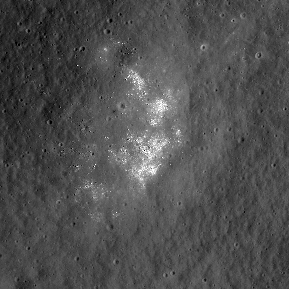
Portion of LROC NAC image M112421089RE showing fresh boulders on the inner ring of lunar far side Hertzsprung Basin, thought to be nearly pure anorthosite. Image is approximately 690 meters across and the Sun is from the right of the frame (east) [NASA/GSFC/Arizona State University].

Ross Beyer
LROC News System

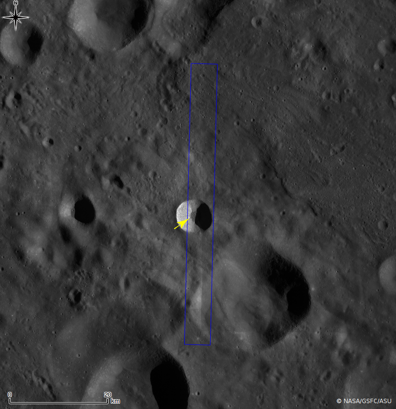
Lunar Reconnaissance Orbiter (LROC) narrow angle camera (NAC) Featured Image focuses in on the Hertzsprung Constellation Tier One Region of Interest, detailing an area of the 270 kilometer diameter Inner Ring of the Hertzsprung Basin (570 km diameter) on the lunar far side. This basin is of the early Moon's Nectarian period (> 3.8 billion years) and is intermediate in size between two-ring basins (e.g., Schrodinger) and larger, multi-ring basins (e.g., Orientale). As such, it excavates material from an intermediate depth that helps us better understand the composition and structure of different zones of the lunar crust.


WAC context view of the inner ring of Hertzsprung basin and the 40x40 km Constellation region of interest. Arrow indicates the approximate location of NAC detail above. Image M118315549ME [NASA/GSFC/Arizona State University].


This site is a great exploration target because it provides access to the inner portion of the basin and the inner ring, which is thought to be nearly pure anorthosite. Explorers based in Hertzprung can investigate basin formation, highlands regolith, and these unique deep crustal rocks from far below the surface. The fresh boulders make perfect samples, and are just waiting for someone to come and pick them up! Nature has provided a natural drill hole to the lower portions of the crust - just the place to determine how the crust formed in the first place.

Browse the entire NAC frame of the Hertzsprung site !

Sunday, December 20, 2009

Far Side Delights

Moon Sheep. Huge boulders seem to have been herded together on the rim of a small and very weathered crater near the northeastern rim of Far Side Hertzsprung basin, south of a line stretched between craters Weyl and Fersman. It's a small far-flung corner in one of 786 images released to the Planetary Data System (PDS) on Friday. Part of an informal test by the Lunar Reconnaissance Orbiter Camera (LROC) team that includes data from images taken during the commissioning of the Narrow-Angle Camera (NAC) survey, Orbits 318 - 354 [NASA/GSFC/Arizona State University].


Square Peg - Another small corner from one of two images among the raw 786 LROC PDS test shots that is unambiguously taken from the deep interior of Mare Orientale. This one, from Orbit 318, is of the chaotic transition between the huge volume of slumped landslide material from the interior basin walls and the basalt-filled middle interior; very near the western side of Hohmann (~264.82E°-17.65°S; Sunrise to the left, f=74.3°) [NASA/GSFC/Arizona State University].


Little House on the Prairie? (Not) - It's the anomalies that catch the eye on first glance. Since the Sun was from the right (f=72.29°) when LRO's NAC shot sequence M102951844R not far from Comstock and well on the Moon's Far Side (~239°E, 20°N) the odd feature is concave rather than convex, indicating an ancient slump of upper material collapsing into a fault of indeterminate scope and origin [NASA/GSFC/Arizona State University].