Tuesday, December 30, 2014

The mystery of lunar layers

Close-up of Silver Spur (bottom) shows linear “bedding” coincident with topography, suggesting it is real. Its stratigraphic significance is still unknown. From panorama of photographs taken during the initial "Stand-Up" EVA, a 360° survey of the Hadley Rille Delta Apollo 15 landing site from the top hatch of the lunar module Falcon just after midnight (UT), July 31, 1971. Dave Scott's panorama included the layered component atop Mons Hadley Delta, whose slopes 5 km east he and Jim Irwin would later sample and explore [NASA/JSC].
Paul D. Spudis
The Daily Planet
Smithsonian Air & Space

In northern Arizona, a spectacular region of exposed, layered rocks over 6,000 feet thick was carved by the Colorado River. Aptly called the Grand Canyon, it represents over a billion years of Earth’s history. Geologists are able to study the history of past ages in exquisite detail by reading the historical record found in that well-known natural landform. No matter the planet, geologists are always searching for layered rocks. The study of rock layers (stratigraphy, from strata, meaning rock layers) allows scientists to reconstruct the geological history of a region and over time, an entire planet.

The nature of the Moon does not lend itself well to the display of rock layers, yet considerable effort has been expended searching for outcrops. Most layered rocks on the Earth are created from water-laid or wind-blown sediments, and neither of those processes occurs on the Moon. Still, the lunar surface has been built up piecemeal by the sequential deposition of blankets of ejecta—the ground-up rock thrown out radially from the center of impact craters and basins during formation. The overlap relationship of these ejecta deposits allows scientists to reconstruct the history of the Moon, i.e., younger impact craters overlie older ones. This simple methodology has allowed us to decipher the stratigraphy of the Moon.

Exposed layering in an outcrop from the rim of the west wall of Rima Hadley (Hadley Rille). A newly inter-laced Apollo 15 image from a panorama of 500 mm black and white photographs at a range of 1400 meters away, on the opposite rim, at Science Station 9a. Dave Scott, August 2, 1971. Features in this view were successfully compared with LROC NAC observations of the area from low lunar orbit [NASA/JSC].
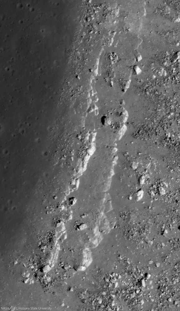
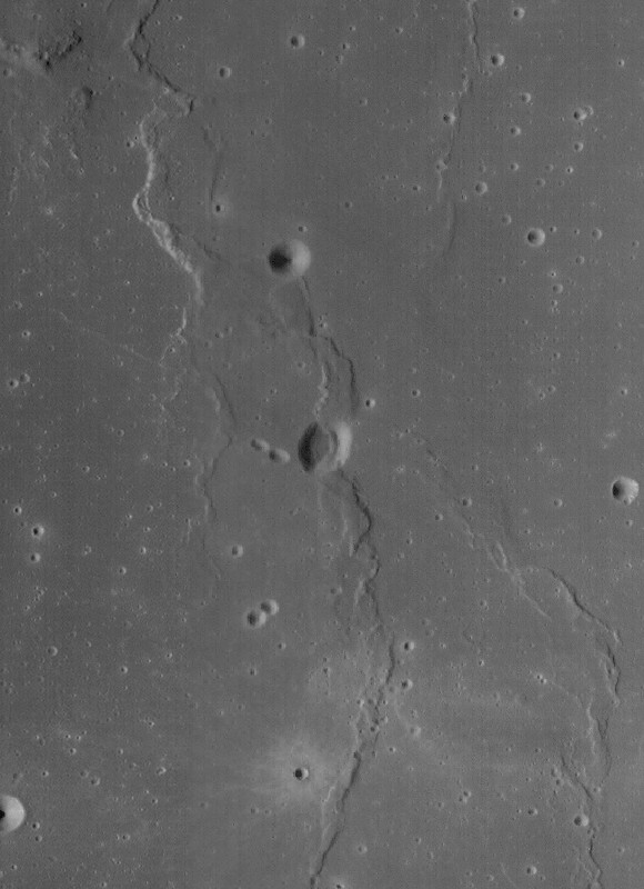
Parallel bedrock outcrops 50 km southwest of the Apollo 15 landing site, from LRO in orbit 38 years later. (From "Layers near Apollo 15 landing site,") The orbital view shows distinct outcrops occurring at different topographic levels within the rille, strongly suggesting the presence of rock layers. The image of the western rille wall by Dave Scott (above) clearly shows a layered outcrop, about 15 meters thick. Several lines of evidence suggest these lavas are the oldest in the region, about 3.84 billion years old. LROC NAC observation M113941548LE, LRO orbit 1925, November 27, 2009; incidence 59.35° at 50 cm resolution, from 46.04 km over 24.65°N, 2.42°E [NASA/GSFC/Arizona State University].
Given that geologic history, one might expect that some evidence of rock layering was found in the abundant data returned from the Moon, but such evidence is limited and ambiguous. One of the most startling finds during the Apollo missions was a breathtaking view of Mt. Hadley, a lunar mountain north of the Apollo 15 landing site. Astronauts Dave Scott and Jim Irwin were startled to see evenly spaced, sub-horizontal lines in the mountain, similar in appearance to fine-scale layering present in some terrestrial strata. It looked as though the mountain was a single, gigantic crustal block, uplifted and overturned by the impact that created the nearby Imbrium basin. The layering described by the astronauts greatly intrigued the mission scientists, who were unable to clearly see it in real time in the TV pictures sent to Earth.

When the crew returned to Earth, images taken on the surface dramatically showed this layering (above, below). But this presented scientists with a puzzle. Because large impacts are highly energetic, chaotic events, how could they generate evenly spaced, regular layering? Some team members began to suspect that something else was going on. Ed Wolfe and Red Bailey of the U.S. Geological Survey made scale models of the mountain and dusted it with cement powder. They then photographed it under low, oblique illumination, similar to the lighting conditions of the landing site during the mission. Surprisingly, fine-scale linear features were evident in the laboratory “mountain” (above, right), suggesting that the “layering” seen by the astronauts on the Moon may have been an illusion, caused by the low-angle illumination of a particulate, granular surface.

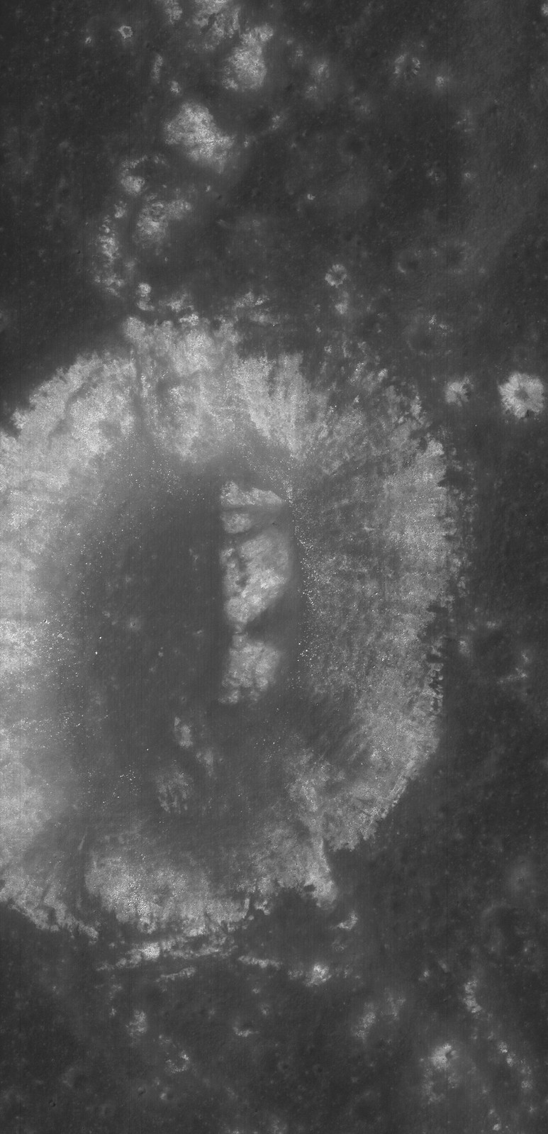
Stratified outcrops steadily shed house-sized boulders from the central peak of Hausen crater (163.24km; 65.111°S, 271.509°E) the formation of which may have excavated among the Moon deeper vertical columns (29 km), in part because of its location on the rim of South Pole-Aitken impact basin. The deepest materials brought to the surface here might include examples of the Moon's mantle, the original material between the Moon's crust and core; time capsules of the Moon's history before the formation of Hadley and the nearside basins. LROC NAC Commissioning observation M105100555LR, orbit 643, August 16, 2009; incidence 72.47° at 48 cm resolution, from 41.38 km over 64.94°S, 271.84°E [NASA/GSFC/Arizona State University].
Full-width mosaic from LROC NAC M105100555LR shows a roughly 1100 meter deep drop from the heights of Hausen's central peak to an intermediate slope of talus in a field of view 2.5 km across [NASA/GSFC/Arizona State University].
Other layered deposits at the Apollo 15 site were less amenable to explanation as an artifact of lighting. A ridge southeast of the landing site named Silver Spur displayed a set of topographic “benches” associated with its apparent layering (below). On Earth, the formation of a bench indicates differential erosion, with hard rocks making up the cliff-forming units and softer rocks being expressed as more gently sloping units. However, such an erosive pattern on the airless, waterless Moon is difficult to envision. To this day, we do not have a good explanation for the origin of Silver Spur. As an example of layering in the highlands, it remains problematical.

Clear and unequivocal layering was observed in the walls of Hadley Rille, a lava channel located near the landing site. In this case, it is easier to accept that we are looking at real layering—the rille cuts into a series of lava flows that cover the landing site (below). Lava flows make up layered deposits on Earth and there is no reason to assume that they wouldn’t do likewise on the Moon. In fact, the layering observed in the walls of Hadley Rille could be significant for another reason, one that may hold great scientific promise for future explorers.

The morphology of the "Aratus CA" collapse pit (24.55°N, 11.78°E) in Mare Serenitatis is unclear, but portions of its southwest rim include layered outcrop, perhaps including a long history of an early intermediate pre-Imbrium period and successive clues to the nature and timing of the catastrophes in our star system's early history called "the Grand Bombardment. 1.74 meter-wide field of view from LROC NAC Commissioning phase observations M104447576LR, LRO orbit 552, August 9, 2009; incidence 57.87° at 1.45 meters resolution, from 145.46 km over 25.15°N, 11.17°E [NASA/GSFC/Arizona State University].
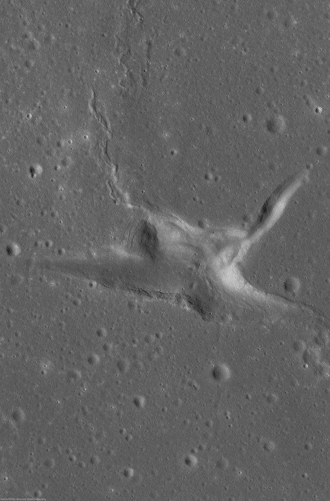
A roughly 11 km-wide field of view from LROC NAC M104447576LR shows the outcrop in context with the larger Aratus CA feature in west central Mare Serenitatis, formed at early period and laid bare by relatively recent events that overburdened the Serenitatis interior [NASA/GSFC/Arizona State University].
After a lava flow is extruded on the Moon, it remains exposed to space. There, over millions of years, the impact bombardment of micrometeorites grinds the once solid lava into a powdery soil called regolith. Because the Moon has no atmosphere, this exposed soil layer contains a record of information about the Sun (gases called the solar wind implant atoms of hydrogen and other light elements in the dust grains) and the galaxy (from high-energy cosmic rays). When a layer is formed and then exposed to space for hundreds of millions of years and subsequently buried (like a time capsule) by another, younger lava flow, that earlier ancient regolith would contain information about the Sun and galaxy not as it is now, but as it was billions of years ago. The idea of an ancient, buried regolith (called a “paleo-regolith”) captured scientists’ imaginations—such a deposit would hold information from an interval of known position and duration in the past (determined by isotopically dating the lavas above and below the ancient regolith).

It appears that such an ancient, buried regolith exists in the walls of Hadley Rille. The lowest layers consist of ancient, relatively aluminous lavas called KREEP basalts. From the dating of Apollo 15 samples, we know that these rocks formed 3.84 billion years ago. Over this layered unit is a covered interval about 10-20 meters thick (a friable, slope-forming unit, like regolith). Above this slope-former are two massive rock layers, a thick massive unit and a thin, finely layered unit. These upper two units probably consist of mare basalt lavas of the two types found at the Apollo 15 site, both of which date to around 3.3 billion years. Thus, the regolith lying between these lava flows may hold the record of more than 500 million years of solar and galactic history, an interval from the distant early portion of Solar System evolution.

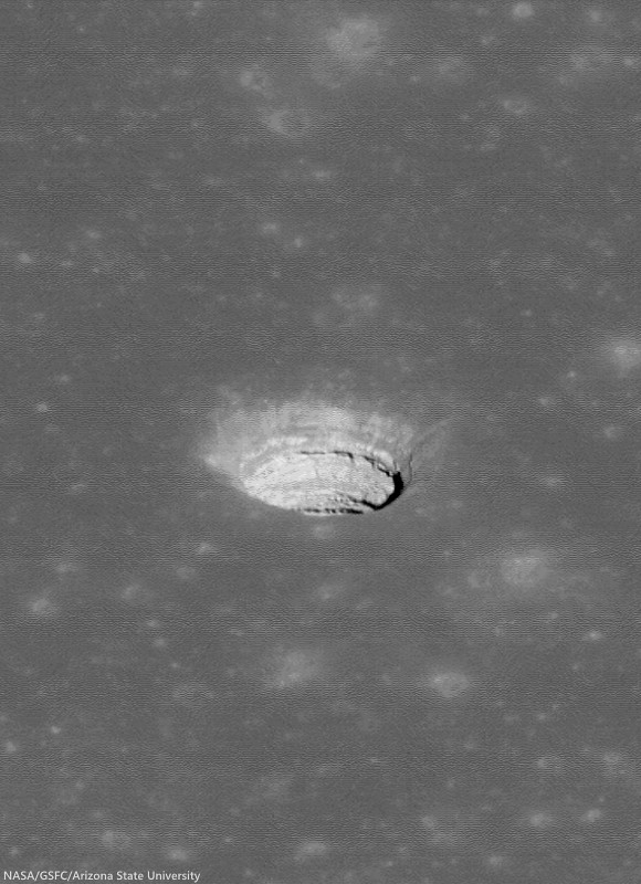
The now-notable original oblique view of the Tranquillitatis pit crater (8.34°N, 33.22°E), revealing, layer by layer the invaluable history of an area in the universe occupied by Earth. LROC NAC observation M144395745LE, LRO orbit 6413, November 14, 2010; spacecraft and camera slewed 50.46° from orbital nadir, incidence 47.91° at 81 cm resolution, from 44.23 km over 8.75°N, 35.02°E  [NASA/GSFC/Arizona State University].
In addition to the history of the Sun, this paleo-regolith would also contain fragments of impact-melted rocks and glasses from a distinct, bounded interval of lunar history. Such a sample would allow us to assess whether the impact flux on the Moon in this time period was comparable to or different from the current rate. Such information is relevant to understanding the impact history of the Earth, a factor that we know from lunar science to strongly influence the rate of evolutionary change. Astronauts descending into the rille could sample all of these units in turn, allowing scientists to reconstruct this ancient history in detail. In this sense, Hadley Rille would be analogous to Earth’s Grand Canyon—a slice into the deep time history of the Moon.

New high-resolution images of the Moon from NASA’s Lunar Reconnaissance Orbiter show that layered deposits, such as those seen in Hadley Rille, are common in the walls of rilles and impact craters occurring in the maria, where layered lava flows are expected. Finding layering in the highlands is more problematic, although some large ejecta blocks appear to consist of layered rocks, quarried out of the crust during impact. We seek such rock layering on the Moon for the same reasons that geologists look for them on the Earth—as time capsules to be carefully opened and read, giving us new insights into the complex history of the Moon.

Originally published as his Smithsonian Air & Space Daily Planet column, Dr. Spudis is a senior staff scientist at the Lunar and Planetary Institute. The opinions expressed are those of the author but are better informed than average.

Related Posts:

Tuesday, December 16, 2014

Chang'e-3 lander still operational on 1st year anniversary

LROC NAC oblique mosaic M1145007448LR, LRO orbit 20773, January 14, 2014; slew 54° from orbital nadir, incidence 63.54° incidence angle, resolution 2.78 meters from 148.73 km over 45.65°N, 329.82°E [NASA/GSFC/Arizona State University].
ECNS - The Chang'e-3 lander continues to perform following 13 full lunar days, the solar powered spacecraft began its 14th hibernation, beginning its most lunar night since its soft landing one year ago, this past weekend. 

The People's Daily reported on Monday, the Chang'e-3 lander "will continue to carry out additional tasks."

During its year on the moon's surface, which included 13 full dormancies on lunar nights and awakenings on lunar days, the Chang'e-3 lunar probe endured the extreme cold environment and carried out more than 30 radio surveys, says Cui Yan, chief designer of the Chang'e-3 lunar program at the Beijing Aerospace Control Center (BACC).

"The Chang'e-3 lander has accomplished all its scheduled tasks, but given its good condition, we plan to conduct further experiments to accumulate more technical experience for China's deep space exploration," says Cui.

The Chang'e-3 lunar probe was launched at the Xichang Satellite Launch Center in southwest China at 1:30 am on Dec 2, 2013, and soft landed on the moon's surface at 12:14 pm on Dec 14 that year. China is the third country to soft land a spacecraft on the surface of an extraterrestrial body.

Related Posts:
LRO: Finding Chang'e-3 (December 15, 2013)
It's not bragging if you do it (December 9, 2013)
Chang'e-3 launched from Xichang (December 1, 2013)
Helping China to the MoonESA (November 29, 2013)
China's Long March to the Moon (January 14, 2012)

20th Release of LRO data to the PDS

It's time in the Sun finally came, last September. Marius K (3.61 km; 9.4°N, 309.3°E), south of its namesake, southeast of Reiner Gamma in Oceanus Procellarum, was among the few places on the lunar surface not previously imaged at high-resolution by LROC cameras. The closer look came at the end of the observational period in the latest, 20th release to the Planetary Data System, December 15, covering roughly mid-June through mid-September 2014. LROC NAC observation M1165144506R, LRO orbit 23602, September 12, 2014; 17.25° incidence angle, resolution 1.07 meters from 105 km over 9.93°N, 309.4°E [NASA/GSFC/Arizona State University].See a larger reproduction HERE.
Teams operating sensors on-board the Lunar Reconnaissance Orbiter, including the Lunar Reconnaissance Orbiter Camera (LROC), are currently updating the Planetary Data System with another treasure trove of records covering the three months from mid-June through mid-September.

The will be the 20th such Release to the PDS of information gathered from the remarkable LRO which has been orbiting the Moon since June 2009.

Of course, it must be added, this isn't the first time Marius K, transected by Procellarum wrinkle ridges, has been imaged by the LROC Wide Angle Camera. By way of comparison, the small crater is seen here at center in this 34 km-wide field of view in a LROC WAC monochrome (566 nm) mosaic from two sequential passes on July 24, 2011; 63.3 incidence angle, resolution 58.7 meters from 42.16 km [NASA/GSFC/Arizona State University].
Release 20 of Lunar Reconnaissance Orbiter data is now online at the Geosciences Node. This release includes new data acquired between June 15 and September 14, 2014, for CRaTER, Diviner, LAMP, LEND, LOLA, and LROC. Data can be found on the Geosciences Node LRO page. The Lunar Orbital Data Explorer allows one reliable way of searching and downloading LRO data.

Another image really requiring the viewer to select a full-size option to appreciate its detail. A roughly ten kilometer-wide view of the Reiner Gamma contact zone with the Marius Hills, in Oceanus Procellarum. From 20th release of LROC data released to the Planetary Data System (PDS), December 15, 2014. LROC NAC mosaic M1158112330LR, LRO orbit 22614, June 22, 2014; 67.62° incidence angle, resolution 1.07 meters from 105.12 km over 10.32°N, 304.48°E [NASA/GSFC/Arizona State University].
Full resolution view from the mosaic immediately above, showing on of the out-lying Marius domes apparently subject to the same influences that keep the Reiner Gamma swirl optically immature. Those studying processes on the Moon highly anticipate the tri-monthly releases of LRO data to the PDS, and hasten to search out familiar locations for a fresh perspective, or a first high-resolution view, even more than five years after LRO began operations.
Updates and instructions, etc., are regularly posted to the PDS Lunar Node, HERE.

Thursday, December 11, 2014

ESA to explore lunar probe partnership with Russia

Ten years after planning got underway to place an ESA lander on the rim of Shackleton crater, the design of the MoonNEXT probe was improved by development of the ESA's ATV resupply ship. Still the program was scrapped. But, even as tensions continue between European Union  partners and Russia, ESA's managers have agreed to investigate joining forces with Roscosmos in Russia's lunar program, forestalled by loss of partnership with India, the problem-plagued Fregat vehicle and tight budgets [ESA/Astrium].
Elizabeth Gibney
NATURE

Science ministers in Europe have resurrected plans to explore the Moon’s surface — and the only strategy currently on the table is to join two uncrewed Russian missions. The developments, which follow the shelving of a proposed European Space Agency (ESA) Moon lander two years ago, come amid growing political tensions between Russia and Western nations.

On 2 December, at a meeting in Luxembourg to determine ESA’s policy, the space agency got the go-ahead and funding to investigate “participation in robotic missions for the exploration of the Moon”. Science ministers from the ESA member states did not approve collaboration with Russia specifically, but at the meeting, ESA scientists presented a proposal to join Russia on its missions to put a lander and a rover on the Moon’s south pole.

Money for lunar exploration will come from a pot of €800 million (US$980 million) contributed by ESA’s member states and dedicated to international space exploration; the pot will primarily pay for activities on the International Space Station and the development of a propulsion module for NASA’s Orion spacecraft, which is eventually designed to carry astronauts to deep space, and was tested on 5 December in an uncrewed space flight.

"There be dragons here," no longer applies to the Moon's nearly always, or permanently, shadowed areas at polar latitudes. The Vision for Space Exploration, before it also was scrapped, developed inertia for a brief second golden age of lunar exploration, and it prioritized scientific goals there.

Above, the state of our knowledge about the Moon's south pole in 1994 is compared with where this knowledge base stands today, illustrating one vast improvement in our understanding of the Moon gained at low cost and with great efficiency
 
[NASA/GSFC/JPL/DOD/USGS/Caltech/Arizona State University].
In the 45 years since astronauts first walked on the Moon, no European country or space agency has launched a mission to the Moon’s surface. And no lander or astronaut has been to the lunar south pole, a region thought to contain ice and thus deemed a probable spot for any future permanent lunar base. A 12-kilometre-deep crater there might provide access to material from the Moon’s interior, also making it attractive for scientific study, says Ian Crawford, a lunar scientist at Birkbeck, University of London. The ancient material could reveal details of the collision between a Mars-sized planet and early Earth that is thought to have produced the Moon. “The idea that we've ‘been there and done that’ did last for a long time, but that’s gone away now,” says Crawford. “The Moon still has a lot to tell us.”

Read the full article at NATURE, HERE.

Tuesday, December 9, 2014