Showing posts with label Lunar Morphology. Show all posts

Friday, November 7, 2014

Exploring the lunar subsurface

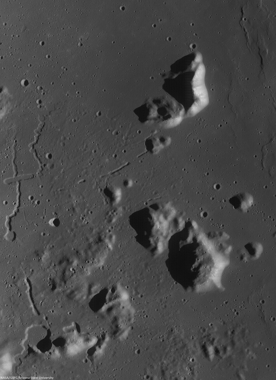
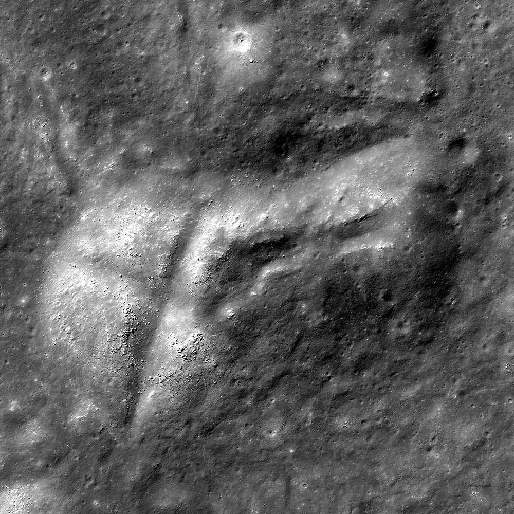
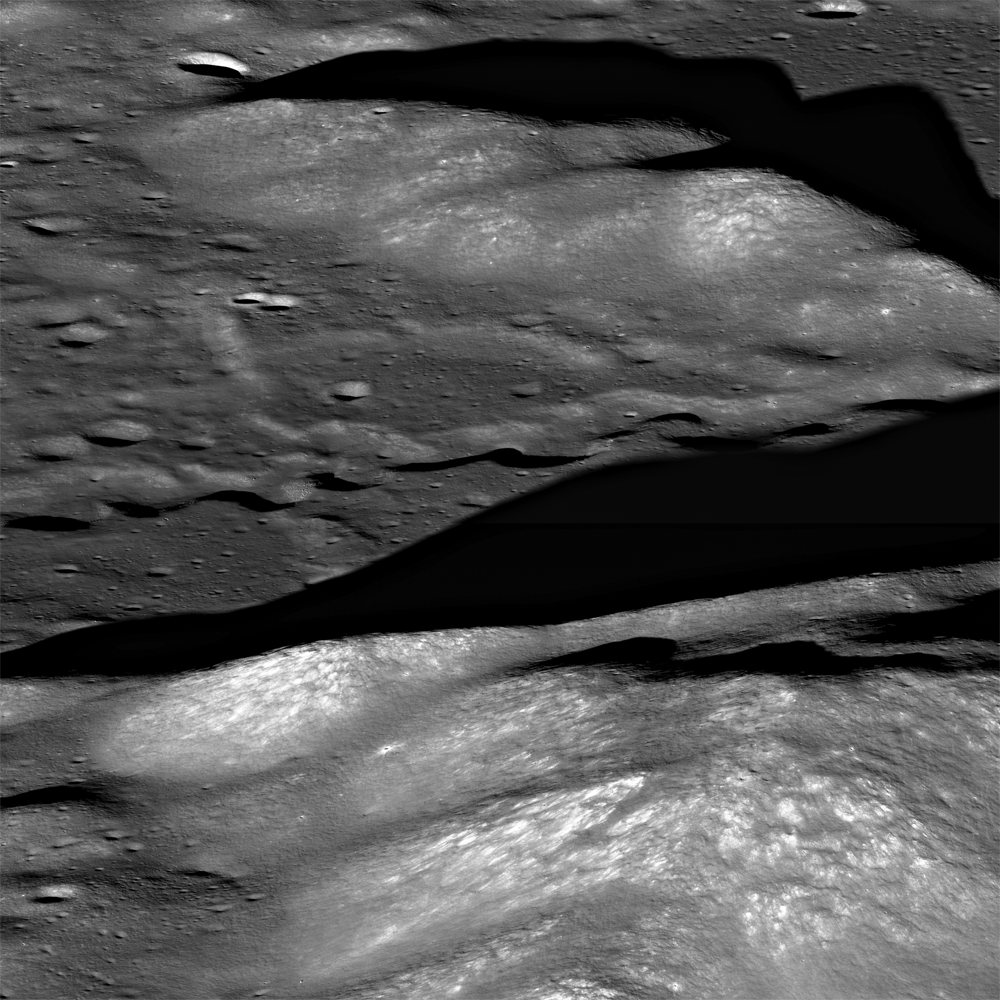
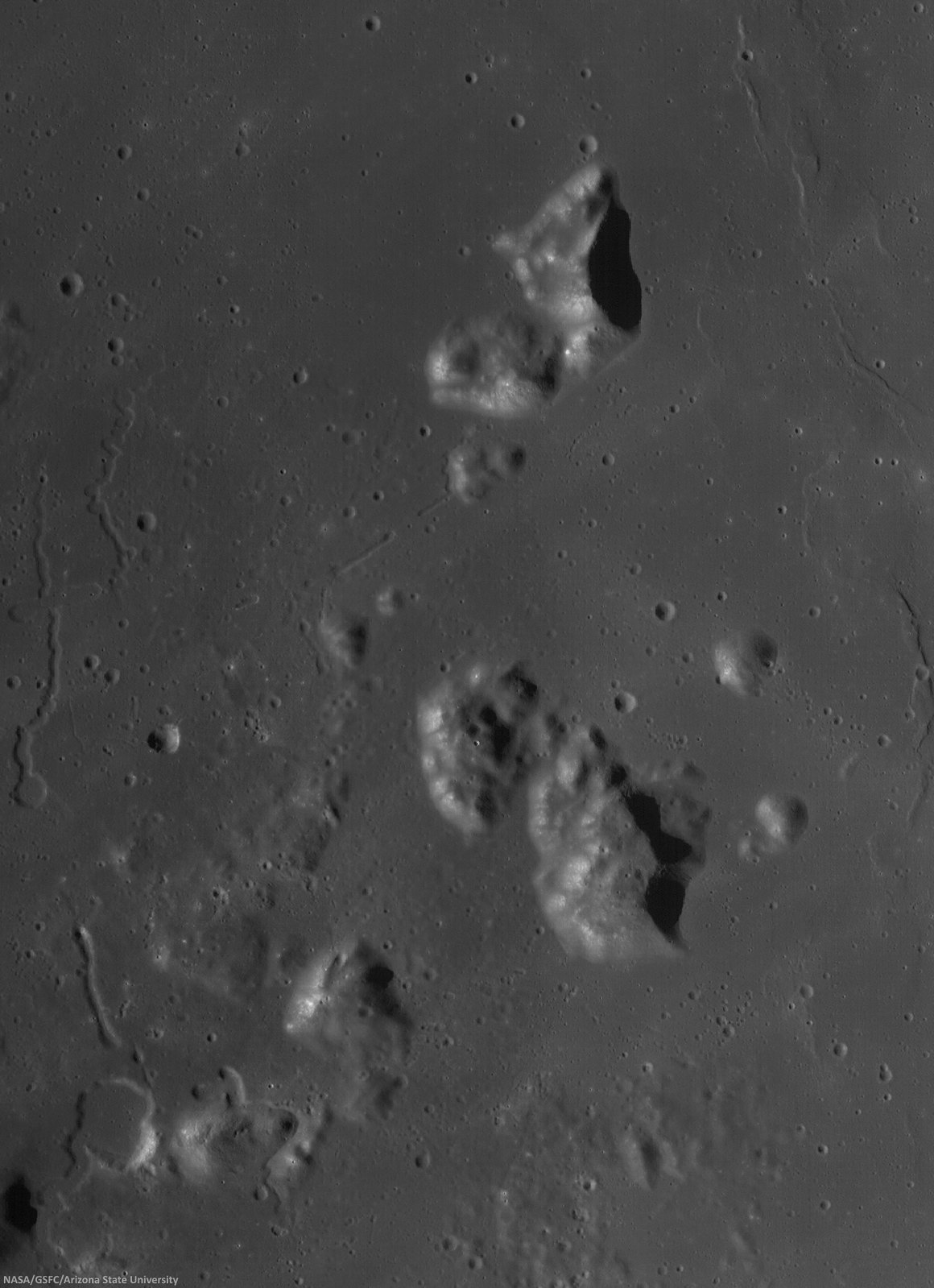
Two collapsed segments of a lava tube run from the southwest to the northeast, in the Rimae Prinz-Harbinger mountain region of Oceanus Procellarum (27.46°N, 318.33°E). These collapsed segments may provide access to the subsurface, which has never been directly sampled. The average width of the collapsed segments is ~650 meters. The lava tube is ~50 meters deep, seen in this 7 km-wide field of view from a mosaic of unreleased 2014 LROC NAC observation M1165080128 (L&R) [NASA/GSFC/Arizona State University].
H. Meyer
LROC News System

A lava tube is a volcanic conduit through which lava travels beneath the hardened crust of a lava flow. The presence of lava tubes on the Moon and beyond are inferred based on observations of terrestrial lava tubes, such as those found in Hawaii. Oftentimes, a rille suddenly disappears only to reappear a short distance away.

These are called discontinuous rilles and are thought to be areas where a lava tube collapsed. Collapsed lava tube segments may provide access to the subsurface, which is exciting as a possible site to collect rock samples that remain unaltered due to surface weathering (radiation, thermal cycling, micrometeorite bombardment).

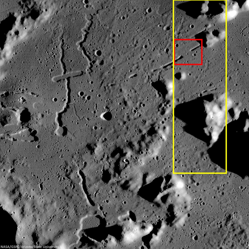
Slightly differing, slightly lower resolution, 11.5 x 15.9 km field of view of the area of interest from a mosaic of LROC Narrow Angle Camera (NAC) observation M1152143995RL, LRO orbit 21776, April 14, 2014; resolution averages 1.33 meters per pixel, incidence angle 48.9° from 132.14 km over 26.86°N, 318.11°E. View the original 8706 x 12008 and an assortment of other sizes HERE [NASA/GSFC/Arizona State University].
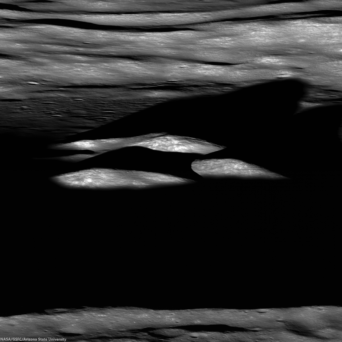
Sunrise over Mons Harbinger. 65 km-wide field of view from mosaic of three LROC Wide Angle Camera (WAC) monochrome (604 nm) observations, swept up during three sequential orbital passes, December 7, 2011,  from 43 km; resolution 58 meters per pixel, incidence 77° [NASA/GSFC/Arizona State University].
Context for LROC Featured Image released November 6, 2014, field of view in red, full field swept up in LROC NAC observations M1152143995R & L in yellow. LROC WAC mosaic [NASA/GSFC/Arizona State University].
The lava tube from the LROC Featured Image released November 5, 2014 is located to the west of Montes Harbinger, a large kipuka in Oceanus Procellarum, and to the east of the Rimae Prinz region.

The Rimae Prinz region displays exquisite sinuous rilles as well as other elongate depressions, indicating that there could be other lava tubes in the area.
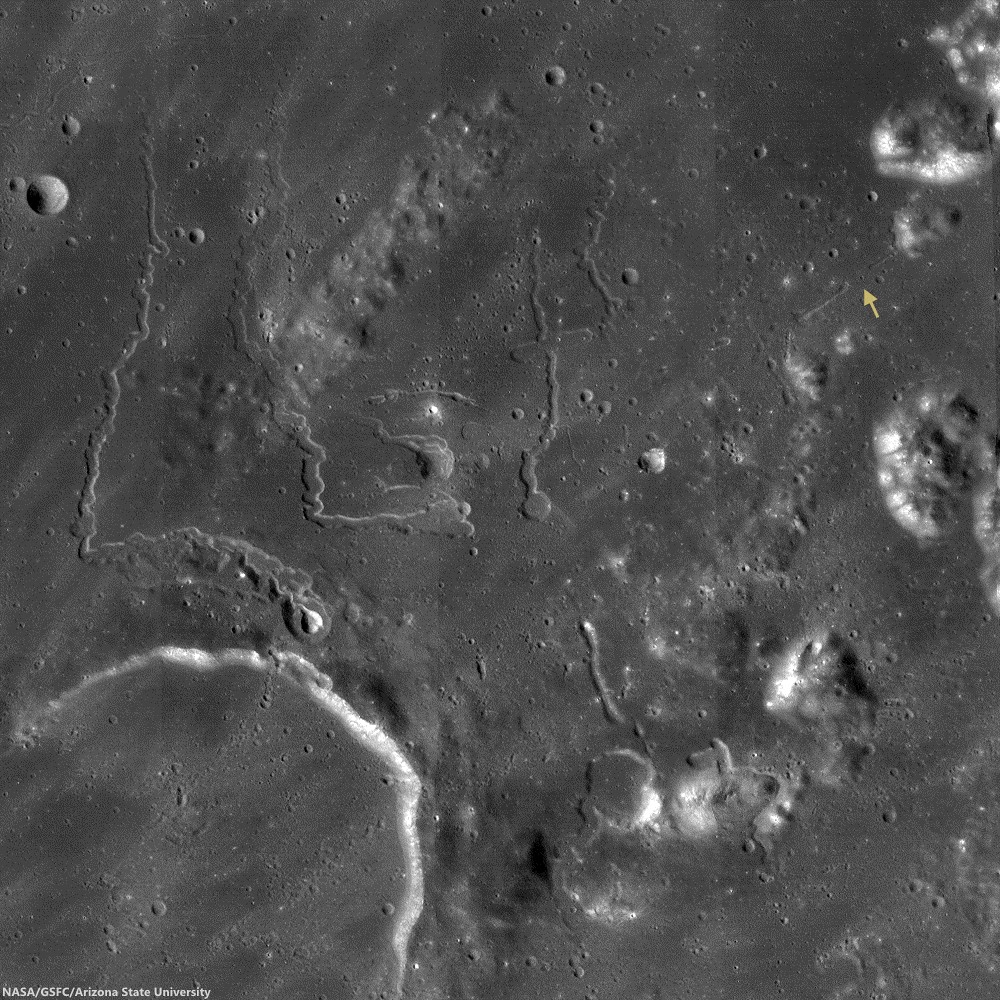
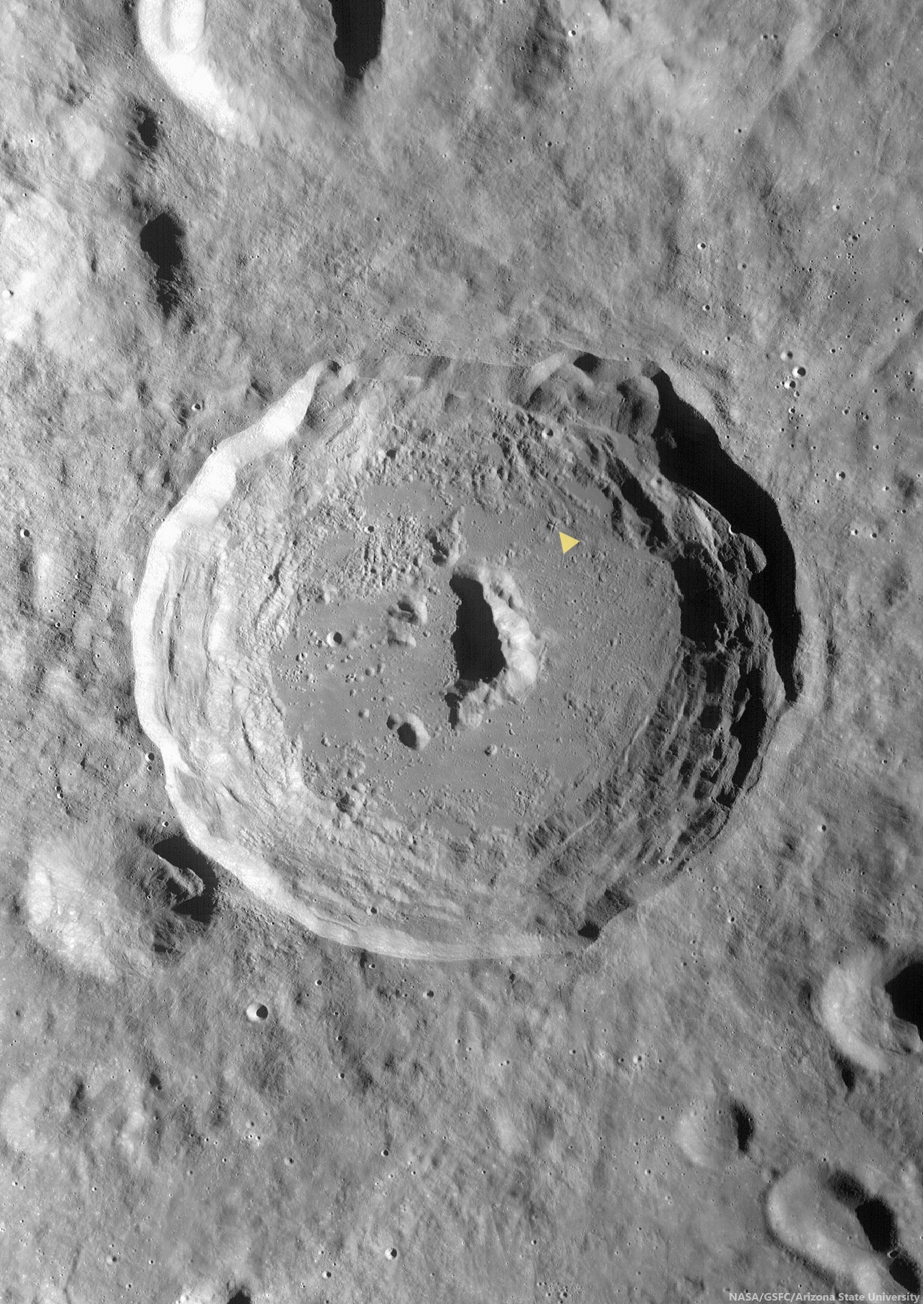
The Prinz, Rimae Prinz and Vera vent region, east of Aristarchus Plateau. The area of interest is marked with a yellow arrow, upper right in this roughly 120 km square field of view from the LROC WAC 100m global mosaic. the Vera vent 'cobra head' of Rima Prinz I rille (on the north-northeast rim of basalt-inundated Prinz crater, at lower left), is the subject of intense study (see HERE). [NASA/GSFC/Arizona State University].
The entire region, pictured above, is of interest for exploration for several reasons. The diversity of volcanic landforms in the area can tell scientists much about the volcanic history of the Moon. By collecting samples from the surface and subsurface in this region and by careful mapping on-site, scientists can better characterize the diverse basaltic lava flows in terms of both age and composition, which also helps us understand the timing and evolution of lunar volcanism and possible heterogeneities in the lunar mantle. Any time a sample is taken from a site on the Moon and age-dated, it can also be used to calibrate crater densities that are currently used to remotely age-date surfaces in the absence of direct sampling (both on the Moon and other planets).

Lava tubes are of particular interest in terms of human exploration because they are not only scientifically valuable, but they might also provide shielding from the radiation that poses a hazard to future explorers. Furthermore, the region surrounding the lava tube from this Featured Image also hosts large pyroclastic deposits, which are a potential in situ resource that will be critical to sustaining a human presence on the Moon.

Scientists and engineers are looking into the possibility of using the natural structure of the lava tube and associated resources (ISRU) to our advantage to construct habitats for explorers.

Explore the full NAC mosaic here! How many features of interest do you see?

Rimae Prinze Region - Constellation ROI
Discontiguous Rilles
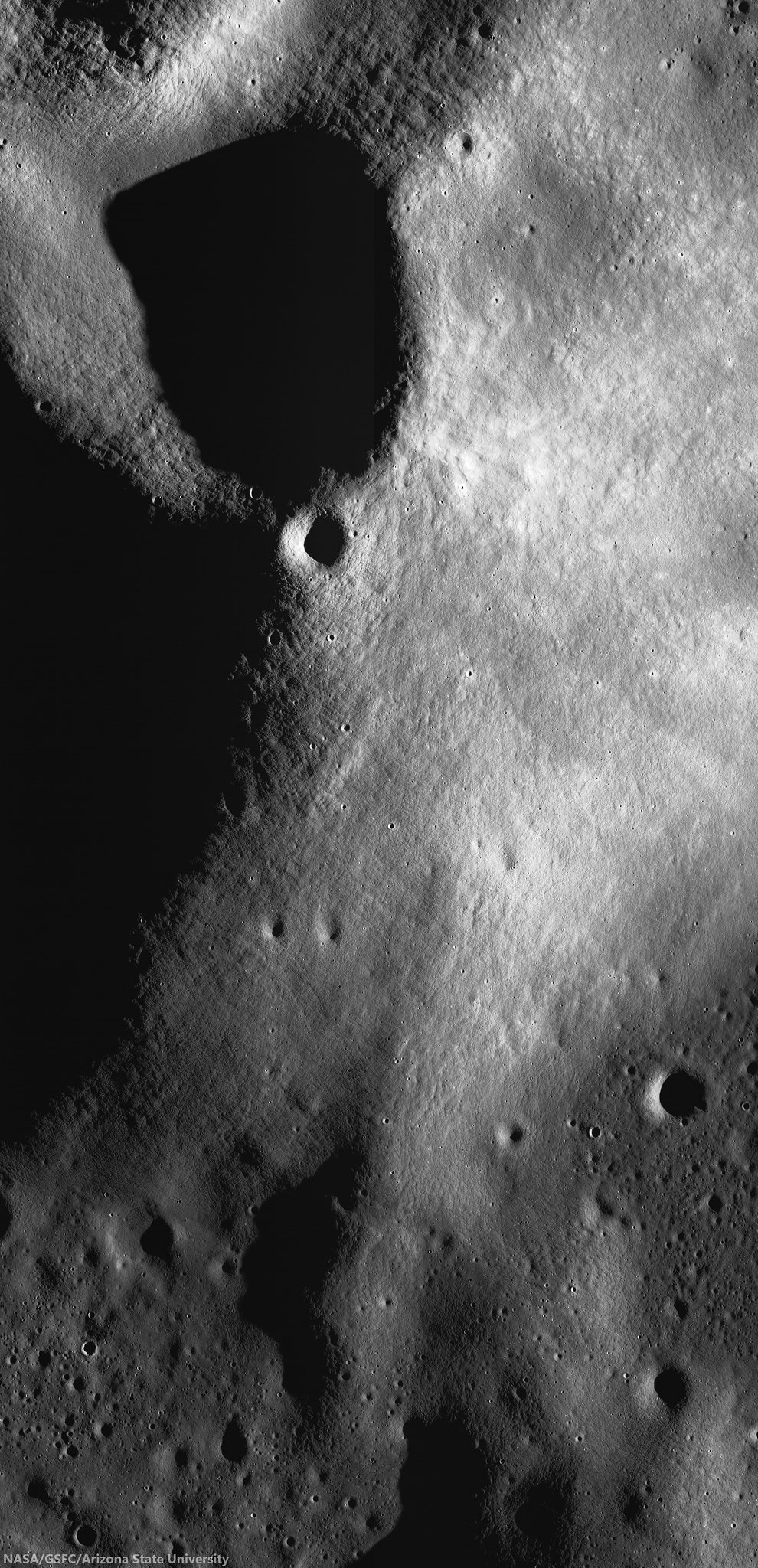
Addendum: Under mid to late afternoon sunlight, another LROC WAC mosaic, swept up under conditions remarkably similar in scale with the third image from above, from the same period of low altitude opportunities the LRO mission afforded during orbital maneuvers in the second half of 2011. Differing sun-moon-spacecraft phase angles allows for an excellent comparison. This particular mosaic was also assembled from LROC WAC observations, but five months earlier, and from three sequential orbital passes, at 43 km altitude. The resolution is 59 meters, incidence angle 64° [NASA/GSFC/Arizona State University].

Friday, March 21, 2014

Faulted Kipula

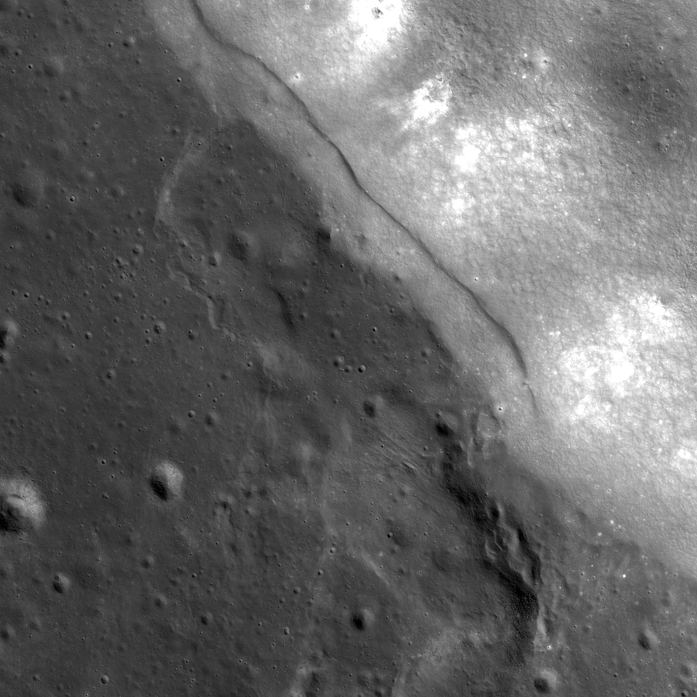
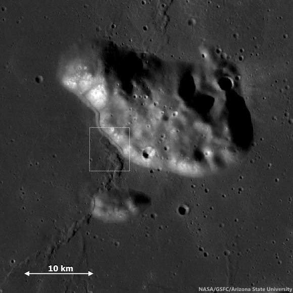
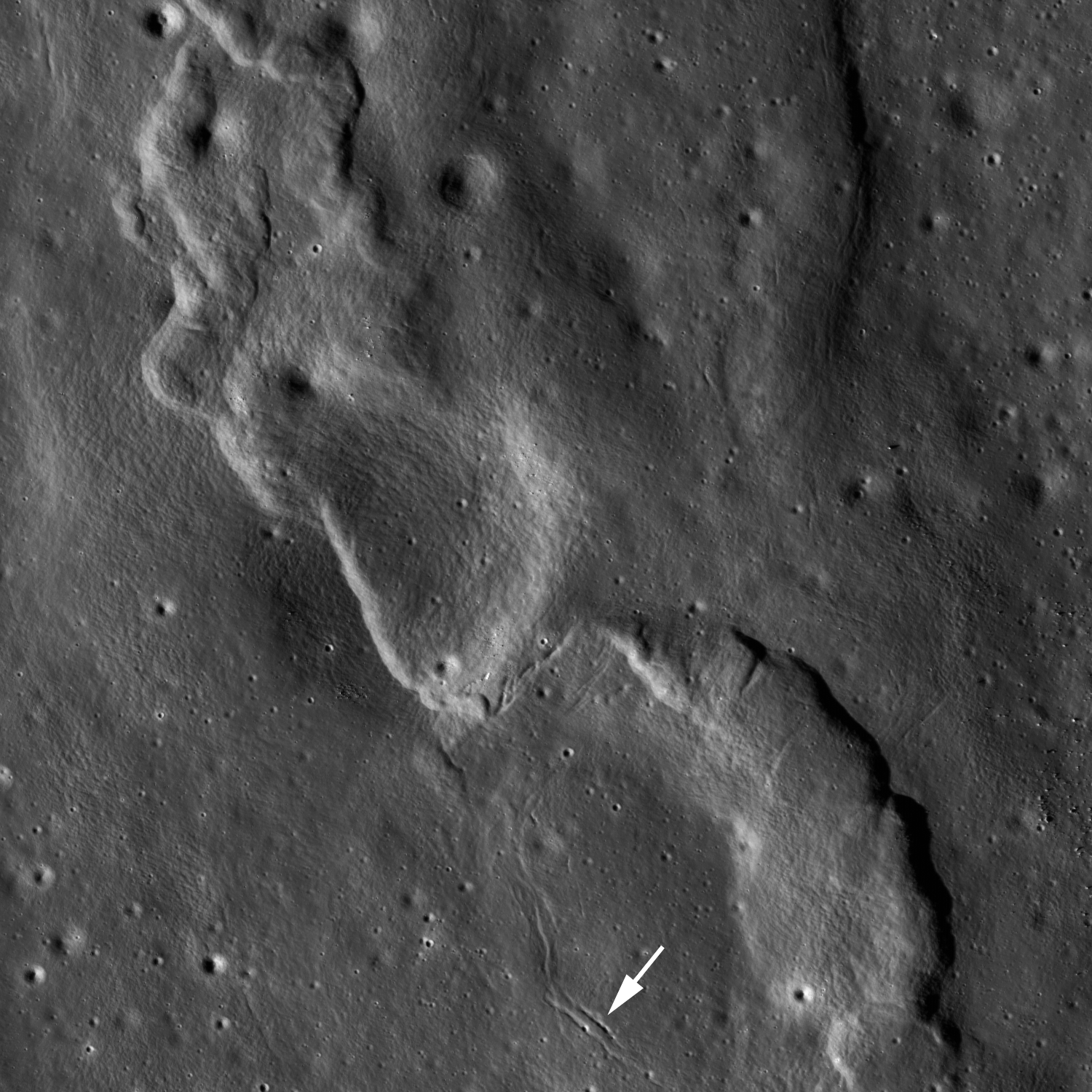
This striking mountain within Mare Imbrium was altered at its base by the formation of a lobate scarp. A wrinkle ridge runs into the base of the mountain (bottom right). Image width is approximately 4.5 km. LROC NAC image M1098943917R, spacecraft orbit 14300, August 7, 2012 [NASA/GSFC/Arizona State University].
H. Meyer
LROC News System

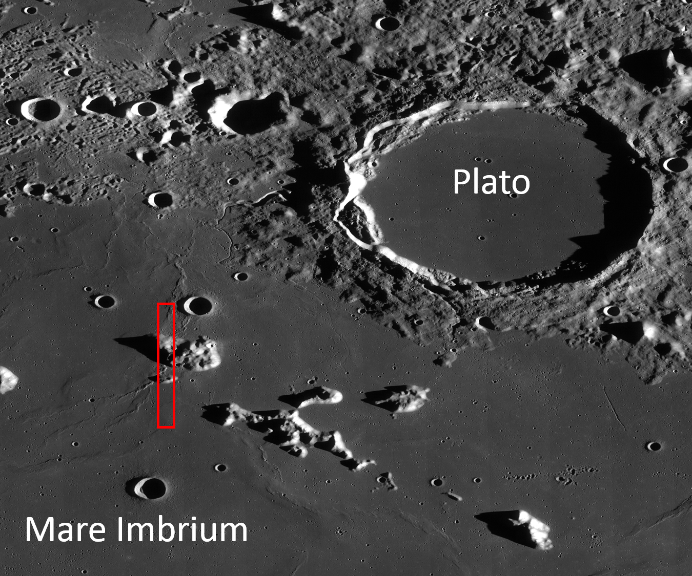
This beautiful mountain, called a kipuka, is located in northern Mare Imbrium on the nearside.

Kipukas are the high-standing remnants of a lava-flooded terrain and are quite common on the Moon. In this case, the kipukas are likely part of the inner ring of the Imbrium impact basin that was later flooded by mare basalts. The lobate scarp in the opening image formed due to contraction and the subsequent upward thrusting of the surface.

This scarp looks very familiar, a twin to the famous Lee-Lincoln scarp that the Apollo 17 astronauts explored in the Taurus Littrow Valley.

Wide Angle Camera mosaic showing the field of view of the LROC Featured Image. LROC WMS Image Browser [NASA/GSFC/Arizona State University].
LROC WAC context image of northern Mare Imbrium centered near 49.459°N, 348.136°E. The red box denotes the location of the NAC frame from which the LROC Featured Image released March 21, 2014 was derived. Landmark crater Plato is approximately 101 km across [NASA/GSFC/Arizona State University].
Another common feature in Mare Imbrium are wrinkle ridges like the one above.

Wrinkle ridges form when the surface undergoes compression due to sagging of the lithosphere below large mare deposits. Local tectonic conditions such as the thickness of the mare, direction of stress, and the strength of the basalt affect the final shape of a wrinkle ridge, yielding a variety of ribbon-like ridge forms.

Investigate this complex area for yourself, HERE.

Related Posts:
That's a Relief
Balcony Over Plato
Wrinkled, But How Old?
Wrinkle Ridge in Mare Crisium 
Remnants of the Imbrium impact

Tuesday, March 11, 2014

Modified Craters of Moscoviense

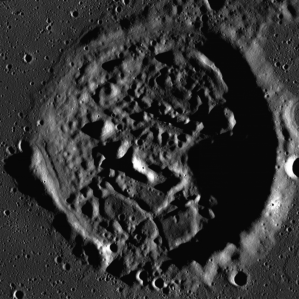
Morning light beams over the walls and peaks of an irregularly shaped crater in Mare Moscoviense. This unnamed crater is approximately 17 km in diameter; portion of controlled NAC Mosaic MOSCOVNSLOA, downsampled for web browsing [NASA/GSFC/Arizona State University].
J. Stopar
LROC News System

This crater is one of several similarly shaped craters in Mare Moscoviense. These craters are pockmarked by craggy peaks and fractured floors. The dramatic illumination in the opening image, with the sun low on the horizon, exaggerates the crater's lumpy topography.

This crater, and others like it, represent one type of volcanically modified impact crater. The floor of the crater, shown in detail below, is not much below the surface of the surrounding volcanic plains, and looks nothing like a typical fresh impact crater, such as Giordano Bruno or simple bowl-shaped crater like this one on the farside. Sharp boundaries with flat-lying mare basalts around the crater rim (arrows) indicate where the crater was once surrounded (embayed) and nearly covered by large outpourings of lava. Only the upper part of the crater rim remains.

Unnamed 17km diameter crater in Mare Moscoviense, located at 146.391°E, 26.805°N. Arrows indicate extent of mare embayment. Click on the image for a higher resolution view of the crater floor [NASA/GSFC/Arizona State University].
How did this crater get so lumpy inside? Did volcanic materials push up from beneath the crater floor? Did molten lava intrude through fractures or low points in the crater rim and walls? Did the heat of nearby lava and magma deform the crater like hot plastic? The answer may be a combination of these processes, though most scientists think that the changes in crater shape occur mainly as a result of magma intruding from below.

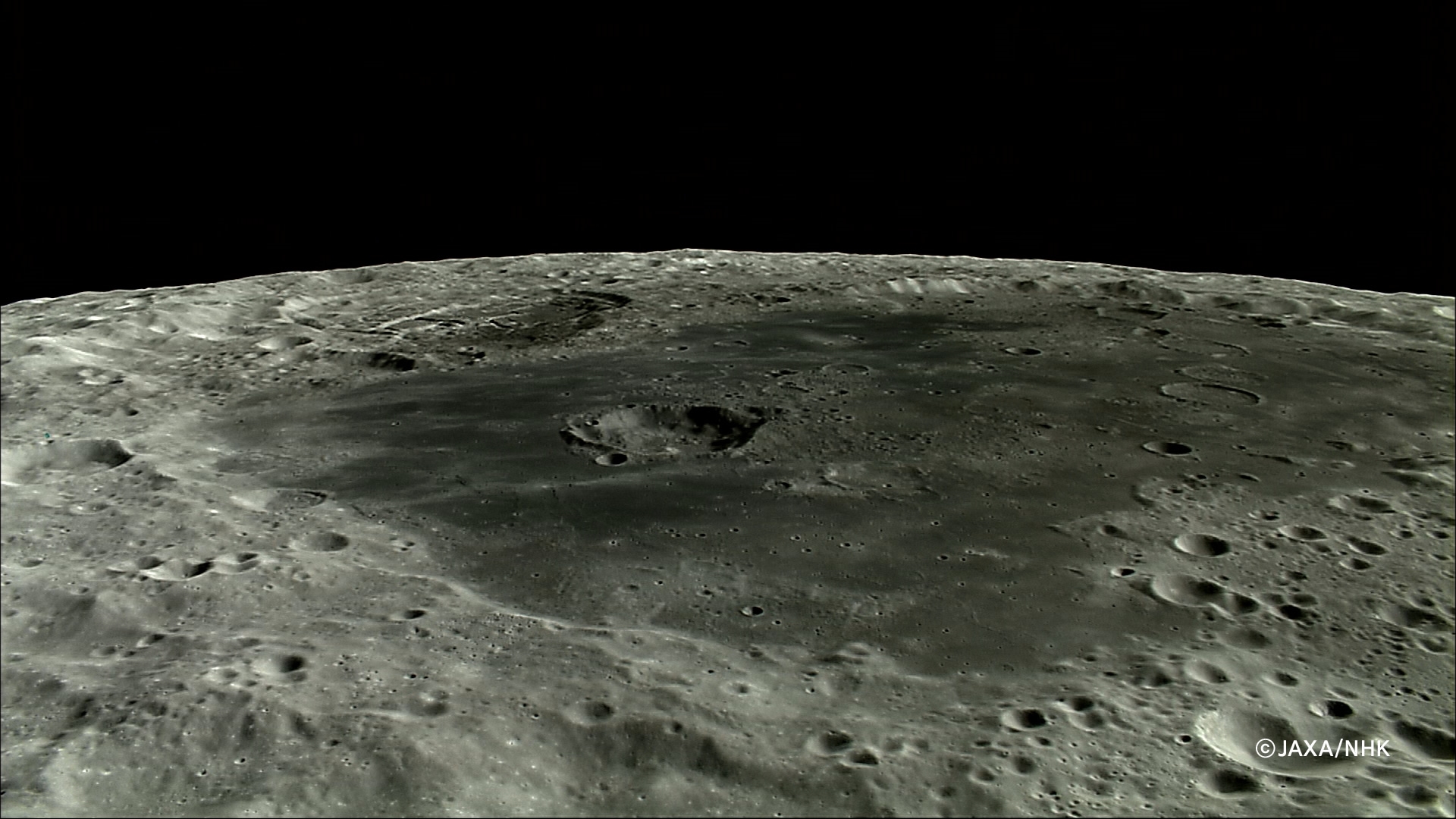
HDTV still from Japan's lunar orbiter SELENE-1 (Kaguya) show the horizon to horizon extent of Mare Moscoviense, now known to be an unusually thin part of the Moon's crust in the farside lunar highlands. The view is from the north, from an altitude of about 100 km. The wallpaper-sized original can be viewed HERE [JAXA/NHK/SELENE].
Explore this crater and two more like it in entire NAC mosaic, HERE.

Re-visit these other volcanically modified impact craters:

Friday, January 31, 2014

Geologic characteristics: Chang’E-3 exploration region

From extensive data distilled from remote sensing collected by the DIVINER Lunar Radiometer on-board the Lunar Reconnaissance Orbiter (LRO) since July 2009 has allowed David Page and the DIVINER team to produce extensive maps of the thermal behavior "and a range of derived quantities at the Chang'e-3 landing site, described in a separate report released January 5. Distinct areas can be seen in LROC WAC Surveys, with an overlay mapping rock abundance using thermal dissipation temperatures collected at the coldest periods, before local sunrise. DIVINER detected no minimum temperatures in the area below 94°K [NASA/JPL/UCLA/GSFC/ASU].
Zhao, Huang & Qiao, et.al.
Planetary Science Institute
China University of Geosciences, Wuhan

Science China (March 2014)

ABSTRACT: We present topographic, geomorphologic and compositional characteristics of a 1°×1° (~ 660 square kilometer) region centered near the landing site of Chang’E-3 using the highest spatial resolution data available. We analyze the topography and slope using Digital Terrain Model (DTM) generated from Terrain Camera (TC) images. The exploration region is overall relatively flat and the elevation difference is less than 300 meters, and eighty percent of the area slopes are less than 5°. 

Impact craters in the exploration region are classified into four types based on their degradation states. We investigate the wrinkle ridges visible in the exploration region in detail, using TC and Lunar Reconnaissance Orbiter (LRO) Narrow Angle Camera (NAC) images. We calculate iron oxide and titanium dioxide abundances using Multispectral Imager (MI) data and confirm two basaltic units: the northern part, belonging to Imbrium era low-titanium to very-low titanium mare basalts, and the southern part is Eratosthenian era low titanium to high titanium mare basalts. 

Finally, we produce a geological map and propose the geologic evolution of the exploration region. 

M177x3C_604nm-anot-580x800
The north central Mare Imbrium exploration region and landing site of Chang'e-3.  The geology report dates the northern mare to the Imbrium Age and the southern mare, in the lander's immediate vicinity to the Eratosthenian age, two billion years apart. LROC WAC mosaic swept up in three sequential orbits, December 5, 2011; sunrise angle of incidence 76° at 61.5 meters per pixel resolution, from 44.7 km [NASA/GSFC/Arizona State University].
INTRODUCTION: Nearly 40 years after the completion of the Apollo and Luna missions, the third Chinese lunar mission, Chang’E-3 (CE-3), was launched on December 2, 2013 and safely landed on the surface of the Moon on December 14, 2013.

The rover “Yutu” separated from the lander successfully about 8 hours later. The landing site of CE-3 is 44.12°N, 340.49°E, which is located in the northern part of Mare Imbrium. As the first Chinese lunar soft-lander and rover, the landing site was selected primarily considering engineering constraints, including topography, communication and solar illumination.

In addition, local geologic diversity was also taken into consideration, including impact craters, wrinkle ridges, and basaltic materials of different ages. The CE-3 landing site and its nearby terrains have never been visited by any other missions. Therefore, the exploration will shed light on the geologic characteristics, geochemical diversity and evolution of Mare Imbrium.

Geological maps in Apollo era and recent studies reveal regional geologic information for Sinus Iridum and the adjacent terrains. However, the spatial resolution of previous maps is not sufficient for detailed geologic study or for the rover traverse planning considering both scientific and engineering requirements. Luckily, as unprecedented high spatial resolution remote sensing data being acquired by recent lunar missions (e.g., Chang’E 1 & 2, SELENE-1, Chandrayaan-1 and Lunar Reconnaissance Orbiter: LRO), large scale geological mapping and detailed study were possible for prior study of the Chang'e-3 landing site and its exploration region. 

Read or Download the Full Adobe PDF file HERE.

Tuesday, January 21, 2014

Wrinkled? Yes, but how old?

Wrinkle Ridge, Eastern Mare Frigoris
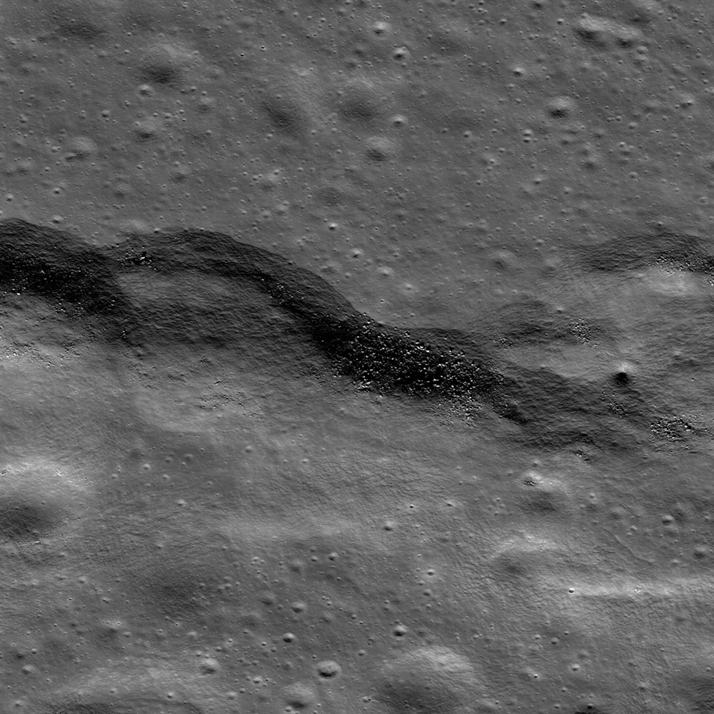
A wrinkle ridge formation in eastern Mare Frigoris (54.430°N, 35.670°E), from a 2 km -wide field of view from LROC Narrow Angle Camera (NAC) observation M139672711R, spacecraft orbit 5717, September 21, 2010; 56.22° incidence angle, resolution 47 cm per pixel from 38.87 km. LROC Featured Image, "Wrinkled, yes, but how old? - Released January 21, 2014 [NASA/GSFC/Arizona State University].
H. Meyer
LROC News System

Wrinkle ridges are not only some of the most striking features that wind their way across the lunar mare, but they are also extremely informative. Wrinkle ridges are the surface expression of tectonic stresses, and from observing the morphology of the ridges, we can interpret the tectonic history of the regions in which they are found.

Mare Frigoris hosts intricate systems of intertwining wrinkle ridges, suggesting a complex history. It is thought that this area was a topographic low that was later filled in with dense mare, causing the less dense anorthosite crust to sag as it underwent isostatic adjustment. The sagging resulted in compression at the surface, and the development of wrinkle ridges. As the crust was compressed it fractured, and long linear stretches of crust were pushed on top of itself thus forming these fascinating ridges.

Wrinkle Ridge, Eastern Mare Frigoris
LROC WAC context image of eastern Mare Frigoris. The full NAC field of view is outlined in red and that of the LROC Featured Image released January 21, 2014 is boxed in yellow [NASA/GSFC/Arizona State University].
The ropy appearance of the ridges in the WAC context image above are a testament to the complex motion that took place within the rock, indicating multiple directions of stress. Though most of the tectonic activity that produced wrinkle ridges in Mare Frigoris is thought to have occurred ~2.6-3.8 billion years ago, recent work suggests that wrinkle ridges may have formed in this region only 1.2 billion years ago. Believe it or not, that is young (for the Moon at least)!

Who knew wrinkles could be useful? Explore the Moon's wrinkles for yourself, HERE

Related Posts:
Bulging Wrinkle
Wrinkle Ridge in Mare Crisium
Wrinkles in Mare Frigoris
Really Wrinkled
Wrinkled Reiner Gamma
Wrinkle Ridge v Impact Crater

Tuesday, January 7, 2014

X marks the spot on the floor of Stevinus

M1131495601RE_thumb-1000
Fractured mound, approximately 3 km in width, on the northeastern floor of Stevinus crater (71.54 km; 32.490°S, 54.137°E) LROC Narrow Angle Camera observation M1131495601R, LRO orbit 18872, August 18, 2013; resolution 78 cm per pixel [NASA/GSFC/Arizona State University].
Raquel Nuno
LROC News System

Today’s Featured Image is an LROC NAC image of an elongated mound (positive relief feature) located on the floor of Stevinus crater [32.49°S, 54.14°E]. The mound has a central fracture along its length, which intersects another perpendicular fracture, forming an "X".

Many mounds of various shapes and sizes are found on the floor of Stevinus crater, but most of them do not have fractures. How did the cracks form on this mound? Perhaps the mound was caused by the upwelling of impact melt beneath a thin solidified crust, as a hardened crust was pushed up it fractured forming the X. Similar morphologies are commonly observed on pahoehoe lava surfaces on the Earth and are known as tumuli.

LO-V-040_M_USGSAS-nodash-580x620
Context for the 3 km fractured mound on the northeastern interior of Stevinus, and near center of this full-resolution crop from medium resolution Lunar Orbiter frame 5040, processed by the United State Geological Service. Lunar Orbiter V, from 163.74 km; 73.37° incidence angle [NASA/JPL/USGS/LPI].
M177278416CE_604nm
Detail northeastern interior Stevinus, centered on the 3 km fractured mound, from LROC Wide Angle Camera (WAC) observation M177278416CE (604 nm), LRO orbit 11261, November 11, 2011; 69.71° incidence, resolution 67.7 meters from 49.6 km [NASA/GSFC/Arizona State University].
Tumuli form when a slow moving lava beneath a brittle crust flows upward, due to an obstruction or a topographical discontinuity, causing the crust to fracture. In our FI, instead of lava, the molten material was impact melt.  Another difference between these lunar mounds and terrestrial tumuli is their size.  On Earth, tumuli are from 2 to 10 meters high; this lunar mound reaches a height of over 160 meters. This is probably due to the lower gravity on the Moon.

M177278416-85207-91969-CE_604nm_stitch-5882-1345x1901
Stevinus and vicinity, arrow marks the fractured mound. LROC WAC observation M177278416CE (604 nm) in mosaic with three subsequent WAC observations from orbits 11262 and 11263, November 11, 2011. View the full-resolution mosaic HERE [NASA/GSFC/Arizona State University].
The rest of this spectacular processed LROC NAC observation can be seen HERE. Can you think of another formation mechanism?

Related LROC Posts:
Pancakes in a melt pond
The Domes of Stevinus Crater
Impact melt channel

Tuesday, December 10, 2013

Strong hints of mixing seen in South Pole-Aitken M3 data

LROCNAC-bhabha_cpeak-1200
Last rays striking the central peaks of Bhabha crater, near the center of South Pole-Aitken basin, an oblique view from the west. LROC Featured Image, "Bhabha sinks into the shadows," July 21, 2010 [NASA/GSFC/Arizona State University].
PROVIDENCE, R.I. [Brown University] — Researchers from Brown University and the University of Hawaii have found some mineralogical surprises in the Moon’s largest impact crater.

Data from the Moon Mineralogy Mapper (M3) that flew aboard India’s Chandrayaan-1 lunar orbiter shows a diverse mineralogy in the subsurface of the giant South Pole Aitken basin. The differing mineral signatures could be reflective of the minerals dredged up at the time of the giant impact 4 billion years ago, the researchers say. If that’s true, then the South Pole Aitken (SPA) basin could hold important information about the Moon’s interior and the evolution of its crust and mantle.

The study, led by Brown graduate student Dan Moriarty, is published in online early view in the Journal of Geophysical Research: Planets.

At 2,500 kilometers across, the SPA is the largest impact basin on the Moon and perhaps the largest in the solar system. Impacts of this size turn tons of solid rock into molten slush. It has been assumed generally that the melting process would obliterate any distinct signatures of pre-existing mineralogical diversity through extensive mixing, but this latest research suggests that might not be the case.

LROCWACDTM-SPA-tour
South Pole-Aitken basin, with Bhabha and Leeuwenhoek craters noted, and more easily seen in the full resolution view, HERE [NASA/GSFC/SVS].
The study looked at smaller craters within the larger SPA basin made by impacts that happened millions of years after the giant impact that formed the basin. Those impacts uncovered material from deep within the basin, offering important clues about what lies beneath the surface. Specifically, the researchers looked at the central peaks of four craters within the basin. Central peaks form when material under the impact zone rebounds, forming an upraised rock formation in the middle of the crater. The tops of those peaks represent pristine material from below the impact zone.

Using Moon Mineralogy Mapper data, the researchers looked at the light reflected from each of the four central peaks. The spectra of reflected light give scientists clues about the makeup of the rocks. The spectra showed substantial differences in composition from peak to peak. Some crater peaks were richer in magnesium than others. One of the four craters, located toward the outer edge of the basin, contained several distinct mineral deposits within its own peak, possibly due to sampling a mixture of both upper and lower crust or mantle materials.

The varying mineralogy in these central peaks suggests that the SPA subsurface is much more diverse than previously thought.

“Previous studies have suggested that all the central peaks look very similar, and that was taken as evidence that everything’s the same across the basin,” Moriarty said. “We looked in a little more detail and found significant compositional differences between these central peaks. The Moon Mineralogy Mapper has very high spatial and spectral resolution. We haven’t really been able to look at the Moon in this kind of detail before.”

The next step is figuring out where that diversity comes from.

M1124763264LR-NSJ-0603-580x1200-61p-2800x5793
High-resolution view of small crater superpositioned on the south central peaks of Leeuwenhoek crater. Chandrayaan-1 Moon Mineralogical Mapper (3M) data studied by researchers at Brown University demonstrates evidence that lunar mantel was upthrust and exposed when Leeuwenhoek formed, perhaps close to the original transitory crater rim of 4.2 billion year old South Pole-Aitken basin. LROC NAC mosaic M1124763264RL, LRO orbit 17925, June 1, 2013; sunrise angle of incidence 83° resolution roughly 1.6 meters per pixel from 77.84 km [NASA/GSFC/Arizona State University].
It’s possible that the distinct minerals formed as the molten rock from the SPA impact cooled. Recent research from Brown and elsewhere suggests that such mineral formation in impact melt is possible. However, it’s also possible that the mineral differences reflect differences in rock types that were there before the giant SPA impact. Moriarty is currently undertaking a much larger survey of SPA craters in the hope of identifying the source of the diversity. If indeed the diversity reflects pre-existing material, the SPA could hold important clues about the composition of the Moon’s lower crust and mantle.

“If you do the impact scaling from models, [the SPA impact] should have excavated into the mantle,” Moriarty said. “We think the upper mantle is rich in a mineral called olivine, but we don’t see much olivine in the basin. That’s one of the big mysteries about the South Pole Aitken basin. So one of the things we’re trying to figure out is how deep did the impact really excavate. If it melted and excavated any material from the mantle, why aren’t we seeing it?”

If the impact did excavate mantle material, and it doesn’t contain olivine, that would have substantial implications for models of how the Moon was formed, Moriarty said.

8-SPA-meltpool-787
Two centers? The center of South Pole-Aitken basin is not yet agreed on, partly because it's oval shape is evidence of an oblique impact and also because of its immense age, with much of its original surface now erased. Subsequent impacts, however, has exposed deeper, perhaps the deepest and oldest materials, from the Moon's original formation [NASA/GSFC/Arizona State University].
Much more research is needed to begin to answer those larger questions. But this initial study helps raise the possibility that some of the original mantle mineralogy, if excavated, may be preserved in the Moon’s largest impact basin.

Carle Pieters, professor of geological sciences at Brown, and Peter Isaacson from the University of Hawaii were also authors on the paper. The work was supported by NASA’s Lunar Advanced Science and Exploration Research (LASER) program and the NASA Lunar Science Institute (NLSI).

Thursday, November 21, 2013

On the chronology of lunar formation and evolution

The Moon about 3 billion years shy of it's most familiar cratering, more or less as it appeared after the basin-forming-impact that created Mare Orientale. From the Goddard / Science Visualization Studio video 'Evolution of the Moon' (2012) [NASA/GSFC/SVS].
A newly published chronology of the Moon's four and a half billion year history, among other things, addresses why certain of its oldest and most familiar nearside basins did not originate from a 'basin-forming-impact.'

Johannes Geiss, Angelo Pio Rossi
The Astronomy & Astrophysics Review   

An origin of the Moon by a Giant Impact is presently the most widely accepted theory of lunar origin. It is consistent with the major lunar observations: its exceptionally large size relative to the host planet, the high angular momentum of the Earth–Moon system, the extreme depletion of volatile elements, and the delayed accretion, quickly followed by the formation of a global crust and mantle.

According to this theory, an impact on Earth of a Mars-sized body set the initial conditions for the formation and evolution of the Moon. The impact produced a protolunar cloud. Fast accretion of the Moon from the dense cloud ensured an effective transformation of gravitational energy into heat and widespread melting. A “Magma Ocean” of global dimensions formed, and upon cooling, an anorthositic crust and a mafic mantle were created by gravitational separation.

Simulation of a Moon-forming impact [Harvard University].
Several 100 million years after lunar accretion, long-lived isotopes of potassium, uranium and thorium had produced enough additional heat for inducing partial melting in the mantle; lava extruded into large basins and solidified as titanium-rich mare basalt. This delayed era of extrusive rock formation began about 3.9 billion years ago and may have lasted nearly 3 billions years.

A relative crater count timescale was established and calibrated by radiometric dating (i.e., dating by use of radioactive decay) of rocks returned from six Apollo landing regions and three Luna landing spots. Fairly well calibrated are the periods from 4 billion to about 3 billion years before present, 800 million years ago to the present. Crater counting and orbital chemistry (derived from remote sensing in spectral domains ranging from gamma and x-rays to the infrared) have identified mare basalt surfaces in Oceanus Procellarum that appear to be nearly as young as 1 billion years.

Samples returned from this area are needed for narrowing the gap of 2 billion years in the calibrated timescale. The lunar timescale is not only used for reconstructing lunar evolution but serves also as a standard for chronologies of the terrestrial planets, including Mars and possibly early Earth.

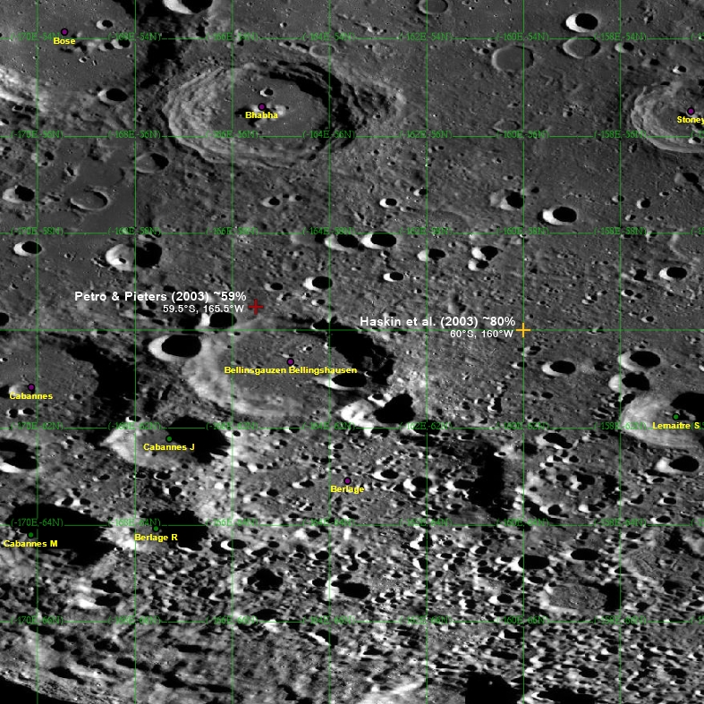
Head / Brown 2010 crater count
James W. Head of Brown University performed a global census 5,185 lunar craters less than 20 km in diameter (2010). Not surprisingly, a thinner population of such craters are found in and around familiar near side basins, reconfirming conclusions from long ago that the huge plains represent younger surfaces [NASA/GSFC/LOLA/Brown/SVS].
The Moon holds a historic record of Galactic cosmic-ray intensity, solar wind composition and fluxes and composition of solids of any size in the region of the terrestrial planets. Some of this record has been deciphered. Secular mixing of the Sun was constrained by determining the ratio of helium-3 to helium-4 of solar wind helium stored in lunar fines and ancient breccias. For checking the presumed constancy of the impact rate over the past (roughly) 3.1 billion years, samples of the youngest mare basalts would be needed for determining their radiometric ages.

Radiometric dating and stratigraphy has revealed that many of the large basins on the near side of the Moon were created by impacts about 4.1 to 3.8 billion years ago. The apparent clustering of ages called “Late Heavy Bombardment (LHB)” is thought to result from migration of planets several 100 million years after their accretion.

The bombardment, unexpectedly late in solar system history, must have had a devastating effect on the atmosphere, hydrosphere and habitability on Earth during and following this epoch, but direct traces of this bombardment have been eradicated on our planet by plate tectonics. Indirect evidence about the course of bombardment during this epoch on Earth must therefore come from the lunar record, especially from additional data on the terminal phase of the LHB. For this purpose, documented samples are required for measuring precise radiometric ages of the Orientale basin and the Nectaris and/or Fecunditatis basins in order to compare these ages with the time of the earliest traces of life on Earth.

A crater count chronology is presently being built up for planet Mars and its surface features. The chronology is based on the established lunar chronology whereby differences between the impact rates for Moon and Mars are derived from local fluxes and impact energies of projectiles. Direct calibration of the Martian chronology will have to come from radiometric ages and cosmic-ray exposure ages measured in samples returned from the planet.

The full science paper is behind Springer's paywall, HERE.

Related Posts:
Earth and Moon share primal water source (May 10, 2013)
Thin Crust Moon (April 24, 2013)
Making the Moon: Two New Models (October 25, 2012)
Water from the Sun (October 17, 2012)
Hit-and-Run Science, Paul Spudis (September 30, 2012)
A Sawtooth-like timeline for the first billion years of lunar bombardment (August 28, 2012)
A new 'hit and run' Giant Impact scenario (July 28, 2012)
"Our view of the Moon has turned upside down" (April 26, 2012)
Ti paternity test fingers Earth as Moon's parent (March 28, 2012)
NLSI team sheds light on 'late heavy bombardment' (February 28, 2012)
Cataclysmic Conundrum, Paul Spudis (February 14, 2012)
'Significant change' in bombardment timing (January 6, 2012)
LOLA data improves the crater count (September 19, 2010)

Friday, November 15, 2013

The Lunar Alps

Rille in the Montes Alps
A portion from LROC Narrow Angle Camera oblique mosaic M177602135LR, and a rille, seen in the center of this image, running northwest to southeast through the Montes Alpes northwest of Mare Imbrium. Field of view approximately 15 km (north to the right). Spacecraft orbit 11309, December 4, 2011; average resolution 3.12 meters per pixel from 41.6 km over 49.86°N, 4.3°E [NASA/GSFC/Arizona State University].
H. Meyer
LROC News System

Rilles are common on the Moon and are considered one of the most fascinating volcanic features due to their wide range of scales (100's of meters to over 100 kilometers in length) and morphologies they present (linear, arcuate, or sinuous).

Rilles commonly form when lava flows erode into the existing surface through melting of the substrate, mechanical stripping away of material, or a combination of both thermal and mechanical processes. However, some rilles may have been lava tubes that underwent roof collapse since their formation.

The Lunar Alps
An uncorrected full resolution stitch of LROC NAC mosaic M177602135LR, allowing a false perspective on the rille of interest, west of the spacecraft's orbital track [NASA/GSFC/Arizona State University].
M177602135LR-1500x400
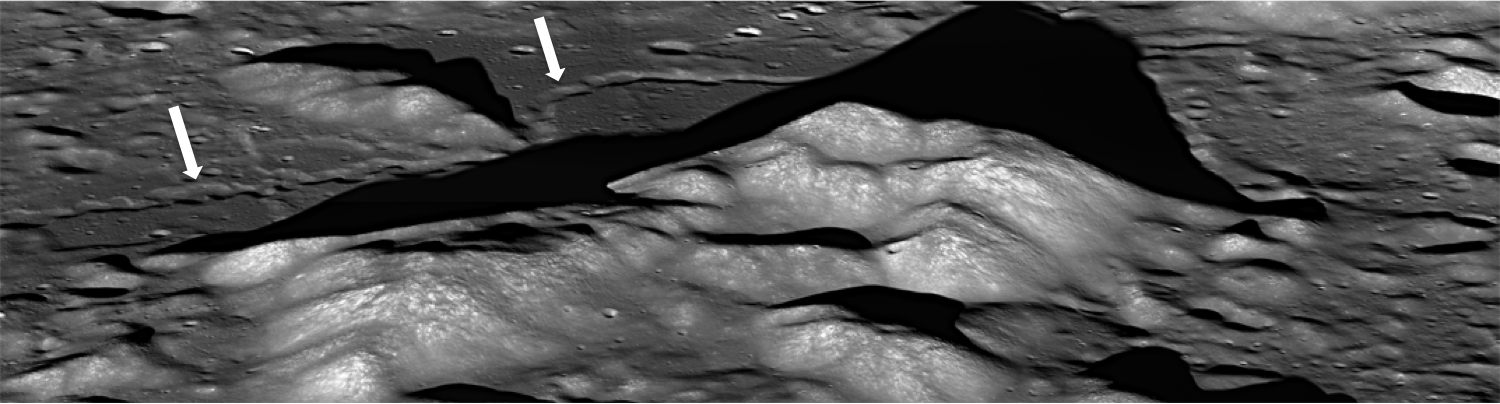
A lower resolution, corrected view of the full LROC NAC oblique. The rille discussed in LROC Featured Image released November 15, 2013 indicated by white arrows [NASA/GSFC/Arizona State University].
In Today's Featured Image, lava carved into the surface between peaks of the Montes Alpes ("Alpine Mountains") and left behind a narrow, long depression resembling a meandering terrestrial river channel, complete with what appear to be cut-off meanders (called oxbows on Earth). In this case, the rille developed meanders as the lava flowed around topographic highs, which in this area are the Montes Alpes.

Vallis Alps, Montes Alps
LROC WAC image of Montes Alpes; field of view approximately 500 km across, centered at 49.397°N, 358.731°E. LROC Featured Image area outlined by the red rectangle [NASA/GSFC/Arizona State University].
Montes Alpes, named by the Polish astronomer Johannes Hevelius, is a mountain range formed by the Imbrium impact event, stretching from the crater Plato all the way to the Montes Caucasus. It forms part of the northeastern border between Mare Imbrium and Mare Frigoris. The Montes Alpes range is bisected by Vallis Alpes ("Alpine Valley"), a flat-bottomed valley with a rille running right down the center from Mare Imbrium to Mare Frigoris that can be seen in the WAC context image above. The Montes Alpes separate the two mare; however, Vallis Alpes breaches that boundary. What might that mean for the geologic history of this area?

Explore Montes Alpes and the rille for yourself HERE.

Related Posts:
Discontinuous Rilles
Old Man River (of Lava!)
Montes Pyrenaeus meets Mare Nectaris

Thursday, October 10, 2013

Wrinkles in Mare Frigoris

M181102837R LROC Featured Image, October 10, 2013
A complex wrinkle ridge deforms Mare Frigoris (52.935°N; 11.131°E) Two kilometer-wide field of view from LROC NAC observation M181102837R, LRO orbit 11804, January 13, 2013; 76.04°evening illumination angle of incidence from the west (left), resolution 1.65 meters per pixel from 168.24 km [NASA/GSFC/Arizona State University].
James Ashley
LROC News System

Lunar mare present many excellent examples of wrinkle ridges, where tectonic activity caused the foreshortening of near-surface rocks. The loading of large basins by dense mare basalts is thought to have resulted in isostatic adjustment of the underlying anorthositic crust, leading to buckling and overriding of surface rock units one atop another as compression occurred. The same stresses may also produce extensional (rather than compressional) deformation in adjacent areas. A variety of complex landforms can thus result.

M146911901CN_604nm-580x800
Area shown at high resolution in the LROC Featured Image is designated with a small arrow in this 34.4 km-wide field of view from LROC Wide Angle Camera (WAC) monochrome (604 nm)observation M146911901CE, LRO orbit 6784, December 13, 2010; early morning 78.67° angle of incidence, resolution 59.3 meters per pixel from 43 km. The area of interest is in south central Mare Frigoris. [NASA/GSFC/Arizona State University].
Most of the ridges we see in today's Featured Image are produced by thrust faulting in Mare Frigoris. Just below center in the Featured Image frame, however, is a left-lateral strike-slip fault (also called a sinistral fault). Wrinkle ridges can be lumpy and ropey-looking, not exactly what comes to mind when one thinks of a textbook compressional fault. But in cross section the faulting would be readily apparent (refer again to the links above). Just south of the strike-slip fault are zones of extension where tension cracks have formed (small white arrow in Featured Image).

M146898354CN_604nm_stitch-58b-1782x2458
Further context for the wrinkle ridge in this field of view 107 km wide south central Mare Frigoris, scared by secondary crater streams from Aristoteles crater to the southeast. LROC WAC monochrome mosaic (604 nm) from five sequential orbits captured under local sunrise (emphasizing topography over albedo), LRO orbits 6782-6786, December 14, 2010 averaging a 77° angle of incidence from 43 km [NASA/GSFC/Arizona State University].
Morphologic nuances can be explored elsewhere in the NAC frame. Note the ropey appearance of some of these ridges, again showing that motions within the rock were complex indeed. Other examples of strike-slip faults have been found in association with lobate scarps on the Moon. Recent evidence suggests that shrinkage of the Moon from deeply seated internal cooling may have contributed to the occurrence of some lobate scarps and wrinkle ridges.

M181102837R
More examples of wrinkle ridges from NAC frame M181102837R [NASA/GSFC/Arizona State University].
Explore the full NAC frame HERE.

Additional examples of wrinkle ridges can be found in LROC Featured Image posts, "Really Wrinkled," "Wrinkle Ridge in Mare Crisium," and "Bulging Wrinkle."

Tuesday, October 8, 2013

Secondaries of all sizes near Mare Moscoviense

M1104980770R_thumb-1000
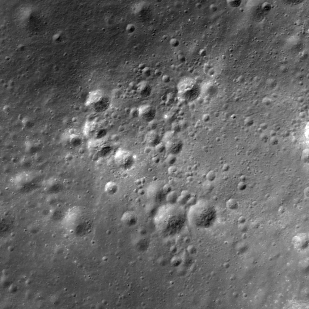
A cluster of secondary craters found in the highlands adjacent to Mare Moscoviense (28.803°S; 142.876°E). LROC Narrow Angle Camera (NAC) frame M1104980770R, LRO orbit 15145, October 15, 2012; 40.69° angle of incidence, resolution 1.08 meters per pixel, field of view about 1.4 km across [NASA/GSFC/Arizona State University].
James Ashley
LROC News System

Secondary craters are produced by debris lofted during excavation of primary impacts. They can be difficult to distinguish from primary impact craters if they are circular with well-developed ejecta patterns. That ambiguity is a concern to scientists when counting craters to determine the ages of planetary surfaces. This age dating approach assumes that impact flux has held steady throughout geologic time following the Late Heavy Bombardment period ending approximately 3.8 billion years ago. The model thus assumes that older surfaces present more craters than younger surfaces, and that one can determine relative ages by counting the number of impact craters per unit area.

M1109480770R at 50 percent
A wide field of view shows a wide variety of secondary crater cluster, from near and far, nearby. LROC NAC M1104980770R; about 2.14 km across [NASA/GSFC/Arizona State University].
Crater counts give reliable relative ages, but can also be translated to absolute ages using the radiometric age dates of rocks returned by the Apollo and Luna missions. Obviously counting statistics are skewed if secondary craters are included in the count; these "extra craters" create the false impression of an older surface.

M167267012CE_604nm-58b-792x1092
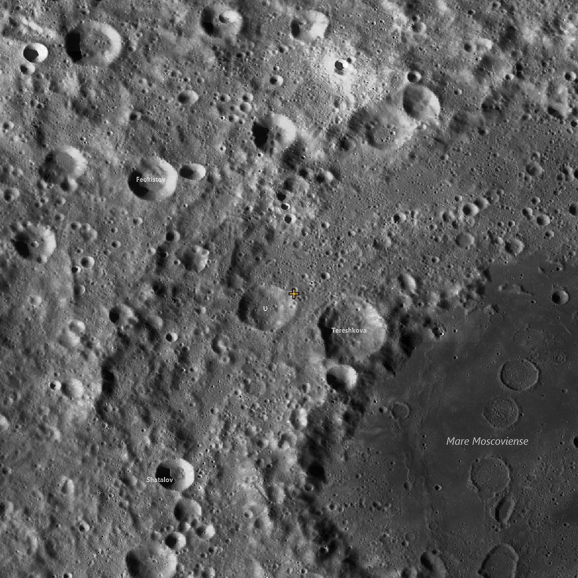
Swarms of secondaries abound. LROC Wide Angle Camera context for the LROC Featured Image, highlighting the area designated with the arrow, on the rim of Tereshkova U, in this 53.5 km field of view, the full width of LROC WAC monochrome (604 nm) observation M167267012CE, LRO orbit 9784, August 8, 2011; spacecraft and camera slewed 8.68° off nadir, angle of incidence 56.66° at 67.5 meters per pixel resolution from 50.59 km over 31.09°N, 142.86°E [NASA/GSFC/Arizona State University].
Often, as in today's Featured Image, the distinction between primary and secondary craters is unambiguous. Here we see a large number of impact craters in a tight cluster. Particularly apparent when exploring the full NAC frame, we can see a clear association within this cluster, not merely a coincidental grouping of separate features spaced in time across many eons. Their ejecta exhibit higher reflectance than most of the craters in the surrounding areas, and they form a tighter grouping than other fresh-looking craters seen elsewhere in the frame.  

LROCQM250-sec-Moscovienese-1180
At 500 meters per pixel, there's no let up in the secondaries peppering the relatively young Moscoviense basin. The cross at center further designates the location, on the rim of Tereshkova U, shown at high-resolution in the LROC Featured Image. LROC WAC mosaic (GLD100) through the LROC Quick Map feature [NASA/GSFC/Arizona State University].
More secondary impact features can be found across the full NAC frame, HERE. Other secondary craters can be explored in earlier LROC Featured Image releases "Swarm of Secondaries," "Dark Secondary Crater Cluster," and "The Rays of Messier A."

Tuesday, September 3, 2013

Excavating Dark Deposits

M185955372RE_thumb-580
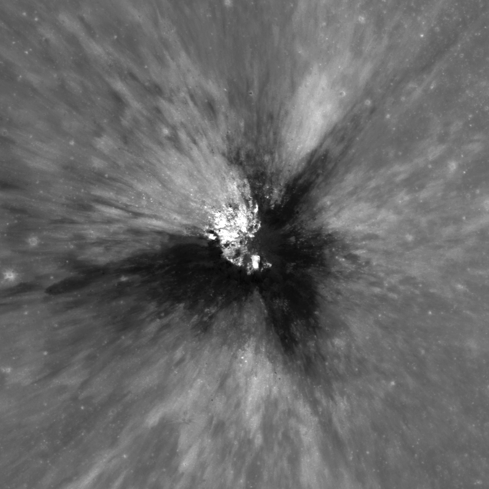
An approximately 250 meter crater has excavated low reflectance material from beneath the lunar surface, west of Sommering P crater, southeast of Copernicus. LROC Narrow Angle Camera (NAC) frame M185955372R; LRO orbit 12483, March 9, 2012; 9.56° angle of incidence, native resolution 1.11 meters per pixel, from 110.79 km over 1.53°N, 249.3°E, field of view 1.8 kilometers [NASA/GSFC/Arizona State University].
Sarah Braden
LROC News System

Amazing ejecta patterns from small, young craters are always something to look at on the lunar surface. Today's Featured Image displays compositional diversity in fresh ejecta. The broad, low-reflectance streaks of material are likely excavated pyroclastic materials. This approximately 250 m diameter crater is located at 2.162°N, 349.401°E, west of the crater Sommering P.

This low-reflectance material is part of a larger area called a Dark Mantle Deposit (DMD). Dark mantle deposits have lower reflectance compared to surrounding mare basalt areas and are also spectrally distinct from mare basalt. In this case, the dark mantle deposit was likely covered by a thin layer of crater ejecta.

Context with Sommering P
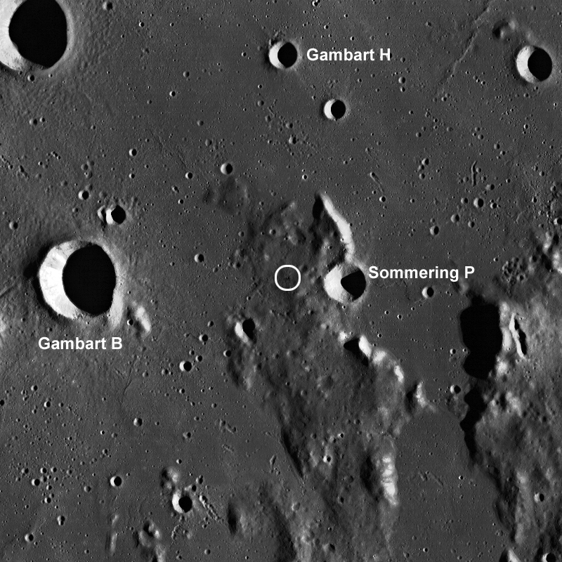
The small crater's location marked with a white circle in an LROC Wide Angle Camera (WAC) context image of a field of view 80 km across [NASA/GSFC/Arizona State University].
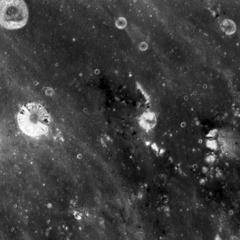
The opening image has a low incidence angle of 10° which means the Sun is high in the sky (near local noon). High-sun images are good for revealing differences in the reflectance properties of the surface. Low-sun (large incidence angle) images are better at emphasizing morphology due to topographic shading and shadowing. Incidence angle is the angle between the vector of sunlight and the vector normal to the surface. The WAC context image above has a large incidence angle (taken in early morning) which makes visible the topographic high where the crater was formed. This topographic high is a remnant of highland terrain (kipuka) surrounded by younger mare basalt deposits (smooth, flat areas). There are many other craters on the topographic high that excavate low-reflectance material, which suggests that the whole area is different from the surrounding mare basalt deposits. The high-sun WAC mosaic (below) of the same area shows the locations where the dark mantle deposit is visible. You can learn more about dark mantle deposits here!

643nm high sun, high-reflectance WAC context
LROC WAC monochrome (643 nm) high sun, high reflectance view of the same area as seen in the WAC mosaic immediately above, resolution roughly 100 meters per pixel. Note darker material around the area of the topographic high place [NASA/GSFC/Arizona State University].
Explore the full NAC image HERE to see the other craters excavating low-reflectance material.

Related Images:
Hyginus Crater and Pyroclastics
Dark Wisps in Copernicus
Polka-Dot Ejecta
Pyroclastic Excavation