Monday, May 31, 2010

Lunar Outpost Life Support Architecture Study Based on a High-Mobility Exploration Scenario


Figure 1. Scenario 12.0.1 Lunar Outpost schematic. Lunar Electric Rovers (LER) are shown without a Portable Utility Pallet (PUP) Larger view available in source and through the image above.

Kevin E. Lange
Jabobs Technology, Inc.

Molly S. Anderson
NASA JSC

International Conference on Environmental Systems
Barcelona, July 11-15, 2010

An American Institute of Aeronautics and Astronautics paper presenting results of a life support architecture study based on a 2009 NASA lunar surface exploration scenario known as Scenario 12.

The study focuses on the assembly complete outpost configuration and includes pressurized rovers as part of a distributed outpost architecture in both stand-alone and integrated configurations. A range of life support architectures are examined reflecting different levels of closure and distributed functionality. Monte Carlo simulations are used to assess the sensitivity of results to volatile high-impact mission variables, including the quantity of residual Lander oxygen and hydrogen propellants available for scavenging, the fraction of crew time away from the outpost on excursions, total extravehicular activity hours, and habitat leakage. Surpluses or deficits of water and oxygen are reported for each architecture, along with fixed and 10-year total equivalent system mass estimates relative to a reference case. System robustness is discussed in terms of the probability of no water or oxygen resupply as determined from the Monte Carlo simulations.

New to the NTRS database, HERE.

MO lunar samples not 'lost,' just forgotten


Fragments of Missouri’s moon rocks are mounted in a case above a Missouri flag that flew on Apollo 11. The case is in storage in the basement of the state Capitol Chris Fritsche/Missouri State Museum/Columbia (MO) Daily Tribune].

Janese Heavin
Columbia Daily Tribune

Fragments of a moon rock collected during the Apollo 17 mission and given to Missouri are safe and sound in the basement of the state Capitol — not lost, as was indicated in a news report last weekend.

The article in Sunday’s Tribune, taken from The Record of Hackensack, N.J., reported that 19 states, including Missouri, could not account for the “goodwill moon rocks” given to states to commemorate NASA’s last manned mission to the moon. After reading the story, staff at the Missouri State Museum went looking for it, said Linda Endersby, interim museum director.

“We knew we had it in our collection; we just didn’t know exactly where it was,” she said. “From the description in the newspaper article, our curator said she saw it and knew where it was.”

Although Missouri’s moon rocks weren’t accounted for, they were never lost, said Judd Slivka, a spokesman for the Department of Natural Resources, which oversees the museum. It’s more accurate to say they simply weren’t found, he said, because no one was looking for them.

Read the article HERE.

Saturday, May 29, 2010

Hearts of Marius, Shadows of Yutu

Updated 1059-1 June 2010 UT


Near the center of the many Marius Hills, recently surmised to be many vents of a single source volcano that China's Chang'e-1 investigators have unofficially named Yutu, the scene above is at the heart of the complex of many small domes, each with a very low profile. These domes are familiar landmarks to earthbound observers, easily visible in modest telescopes only when the sunrise (or sunset) terminator sweeps over Oceanus Procellarum three days before a Full Moon. Within hours these hills, only slightly darker than the surrounding terrain, disappear in the glare. The Sun was less than 2° above the eastern horizon when LRO flew 45 km overhead, during orbit 2329, December 28, 2009, and Arizona State University's LROC Wide-Angle Camera swept up this exposure (M116683214ME) [NASA/GSFC/Arizona State University].

By way of comparison, here (yet again) is a portion of Lunar Orbiter V-152 that shows much the same area seen at the crack of dawn in the LROC WAC frame up above, but in a middle to late morning sun four decades ago. The two tallest of the squat domes or their many neighbors are hardly distinguishable. The twin rilles between them were, however, well out of the shadows. The southern and longer of these channels hosts the "Marius Hole" (or Haruyama Skylight), identified by Japan's Kaguya (SELENE-1) investigators in 2008, near the elbow of it's upper-most bend [NASA/JPL/USGS/LPI]..

We've written and reported a lot about the Marius Hills Volcanic Complex, If there been an Apollo 18 Marius Hills might have been the landing site. Alas, those missions were scrubbed and their architectures were cannibalized for the Skylab and Apollo-Soyuz missions (and the Smithsonian).

Since we're on the subject, even though it's been posted here before in the context of Lunar studies published in connection with the Lunar and Planetary Science Conference in March (seem like only yesterday), a whole "slew" of professional investigators published LROC OBSERVATIONS OF THE MARIUS HILLS in connection with that event.

Clearly, were not paying as close attention as necessary. Originally, in this post, we speculated briefly on why Marius did not appear among the fifty Constellation Regions of Interest, when we knew better. Checking back with our sources, as we thought had, the area around Sinuous Rille A (below, 13.58°N, 304.2°) is definitely listed among those Tier 2 Constellation ROI's.

Coincidentally, you have to get up pretty early in the morning to keep up with the professionals shepherding the Lunar Reconnaissance Orbiter Camera. LROC's Samuel Lawrence posted a very interesting (and timely!) discussion of the Marius ROI date June 1.

From 41st Lunar & Planetary Science Conference (2010)
Figure 3 from "LROC OBSERVATIONS OF THE MARIUS HILLS," 41st Lunar and Planetary Science Conference (2010): LROC Digital Terrain Model (DTM), Sinuous Rille A in the Marius Hills.

Cernan joins Stafford at home in OK to celebrate Gemini, Apollo & Apollo-Soyuz


Lt. Gen. Thomas P. Stafford, (USAF, Ret.) (left) joins Captain Eugene A, Cernan (USN, Ret.) participate in a panel discussion at B.C. Clarks Jewelry store at Penn Square Mall in Oklahoma City, Thursday. Stafford and Cernan flew together on two missions, Gemini 9 and to within 9 kilometers of the lunar surface on Apollo 10. Cernan was the last person to walk on the Moon, in command of Apollo 17 and Stafford flew in command of the first U.S. Soviet rendezvous in space, Apollo-Soyuz, in 1975. The veteran astronauts talked about their missions and answered some questions from the public [The Oklahoman/Paul Hellstern].

David Izzo
NewsOK/The Oklahoman

Just before Tom Stafford and Gene Cernan lifted off for their Gemini 9 space mission in 1966, the flight crew director called Stafford aside. "We can't afford to have a dead astronaut floating around in a space suit,” he told Stafford.

"I wasn't in on that conversation,” Cernan said.

Stafford recalled that director Deke Slayton told him that if Cernan died while on a risky spacewalk that was part of Gemini 9, Stafford should haul the body back into the capsule.

Stafford, the mission commander, listed the many perils of that strategy.

Read more HERE.

Mastin & XCOR to develop unmanned landers

Mastin's Xombie performs during second leg of last October's Northrop Grumman Lunar Lander Challenge.

CSM/Space.com

Two California companies, one a rocket engine builder and the other a mock moon lander champion, have teamed up to develop new private unmanned vehicles that NASA could send to the moon, Mars and asteroids.

The companies are XCOR Aerospace, specializing in rocket engines, and Masten Space Systems — which won a $1 million NASA contest to build and fly robotic vehicles on simulated hops on the moon. The two companies hope to combine their areas of expertise in anticipation of NASA-sponsored unmanned lander projects, according a joint announcement this week.

"It seems like NASA may actually be interested in a commercial approach to landers," Michael Mealling, of Masten Space Systems, told SPACE.com Tuesday.

Read the article HERE.

Friday, May 28, 2010

LROC: Constellation ROI at Hertzsprung Basin


Portion of LROC NAC image M112421089RE showing fresh boulders on the inner ring of lunar far side Hertzsprung Basin, thought to be nearly pure anorthosite. Image is approximately 690 meters across and the Sun is from the right of the frame (east) [NASA/GSFC/Arizona State University].

Ross Beyer
LROC News System

Lunar Reconnaissance Orbiter (LROC) narrow angle camera (NAC) Featured Image focuses in on the Hertzsprung Constellation Tier One Region of Interest, detailing an area of the 270 kilometer diameter Inner Ring of the Hertzsprung Basin (570 km diameter) on the lunar far side. This basin is of the early Moon's Nectarian period (> 3.8 billion years) and is intermediate in size between two-ring basins (e.g., Schrodinger) and larger, multi-ring basins (e.g., Orientale). As such, it excavates material from an intermediate depth that helps us better understand the composition and structure of different zones of the lunar crust.


WAC context view of the inner ring of Hertzsprung basin and the 40x40 km Constellation region of interest. Arrow indicates the approximate location of NAC detail above. Image M118315549ME [NASA/GSFC/Arizona State University].


This site is a great exploration target because it provides access to the inner portion of the basin and the inner ring, which is thought to be nearly pure anorthosite. Explorers based in Hertzprung can investigate basin formation, highlands regolith, and these unique deep crustal rocks from far below the surface. The fresh boulders make perfect samples, and are just waiting for someone to come and pick them up! Nature has provided a natural drill hole to the lower portions of the crust - just the place to determine how the crust formed in the first place.

Browse the entire NAC frame of the Hertzsprung site !

JAXA plans for robotic moonbase by 2020

Japanese Space Agency concept drawing of robotic lunar base [JAXA].

Nancy Atkinson
Universe Today

The Japanese space agency, JAXA, has plans to build a base on the Moon by 2020. Not for humans, but for robots, and built by robots, too. A panel authorized by Japan's prime minister has drawn up preliminary plans of how humanoid and rover robots will begin surveying the moon by 2015, and then begin construction of a base near the south pole of the moon. The robots and the base will run on solar power, with total costs about $2.2 billion USD, according to the panel chaired by Waseda University President Katsuhiko Shirai.

Read the article HERE.

Thursday, May 27, 2010

'Child of Apollo' Jeff Hanley ousted as head of Constellation program

Mark K. Matthews &
Robert Block
Orlando Sentinel

NASA ousted the outspoken head of its Constellation moon program on Wednesday, prompting an immediate protest from congressional lawmakers who again accused the White House of taking steps to kill the project.

Word that Constellation Manager Jeff Hanley was moved to a deputy position at Johnson Space Center reached Congress just as the House science committee was meeting with NASA chief Charlie Bolden to debate White House plans to replace the space shuttle with commercial rockets.

"It is a great concern to us that you take the manager out of his position and reassign him to another position," said U.S. Rep. Gabrielle Giffords, an Arizona Democrat who has fiercely opposed White House efforts to shut down Constellation and its aims to return astronauts to the moon.

Read the article, HERE.

Pentagon industrial policy chief concerned U.S. space industry may lose edge

Space shuttle Atlantis' drag chute slows the vehicle as it rolls down Runway 33 at the Shuttle Landing Facility at NASA's Kennedy Space Center in Florida. Landing was at 8:48 a.m. EDT, completing the 12-day STS-132 mission to the International Space Station. The mission is the last planned for Atlantis, and third to the last planned for the Space Shuttle program [NASA/Sandra Joseph].

MDAA - Brett Lambert, Pentagon’s industrial policy chief, said that the U.S. space industry is getting less competitive against Asian and European firms, eventually threatening decades of U.S. primacy in this area. He argues that it is necessary to ease export controls on technologies to help the financing of the sector.

The dominance of the U.S. space industry is threatened by European and Asian firms, the Pentagon’s industrial policy chief said May 25.

“We’re at a tipping point with our space industry,” Brett Lambert said at a forum on the strength of the space industrial base hosted by the George C. Marshall Institute think tank. “We have for so long been the dominant player and the most technologically advanced player.”

European and Asian countries have developed their space industrial bases “not because they wanted to make those investments [but] because they didn’t have access to our technology,” he said. “As they get more capable, we will become less competitive.”

Read the full article, HERE.

Wednesday, May 26, 2010

LROC: Ingenii Swirls at Constellation ROI


Close-up image of the Mare Ingenii Constellation Region of Interest. Mare Ingenii is one of the few mare basalt deposits on the far side of the Moon, and that fortunate circumstance makes the exquisite lunar swirls here much easier to immediately identify than in brighter areas, such as the innumerable those antipodal to Mare Orientale in the vicinity of Goddard crater. Full Featured Image width = 800 meters [LROC-NAC M105795162R; NASA/GSFC/Arizona State University].

Mike Zanetti
LROC News System

Mare Ingenii is one of the few mare basalt deposits on the farside of the Moon. What makes Mare Ingenii even more unique is that it contains one of the most rare and strange geological features on the Moon: lunar swirls!

Lunar swirls are bright markings found on both mare and highland portions of the Moon. They appear as high albedo swirls and patches. They have no topography, as they are only surficial in nature. Swirls range in size from meters to tens of kilometers in length. The swirls are commonly found antipodal to huge young impact basins: Orientale, Imbrium and Crisium, but also within the large basins at Mare Ingenii, near the Airy Crater, and at Mare Moscoviense. They are accompanied by relatively high magnetic anomalies, which is surprising for a planetary body that does not, and may never have had, an active core dynamo with which to generate a magnetic field. The shapes of the swirls hint at a magnetic origin.

The accompanying NAC image (M105795162R) contains the proposed landing site at Mare Ingenii. The site is found along the albedo variation from bright to very dark terrain within a very large lunar swirl.


A LROC Wide-Angle Camera context image (M103439292ME) superimposed together with LROC NAC M105795162RE on part of Mare Ingenii as reproduced using the Google Earth lunar Digital Elevation Model. The extraordinary patterns of dark lanes separating bifurcated albedo lunar swirls, on otherwise indistinguishable terrain, continues to puzzle investigators. The yellow square is a recommended landing site within the Constellation Region of Interest [NASA/GSFC/Arizona State University].

Three models have been proposed to explain swirl formation: (1) deflection of the solar wind by local magnetic fields, (2) cometary impacts, or (3) impacts of meteoroid swarms. Deflection of the solar wind by local magnetic fields may protect the underlying rocks and soils from space weathering, thus leaving them with higher albedo. Recent cometary impacts might cause the high albedo of the swirls due to scouring of the topmost surface regolith and exposure of fresh, brighter material from below. The meteoroid swarm model is a variation of the cometary impact model,where cometary nuclei are fragmented into a swarm of smaller objects by solar or terrestrial tidal forces before they impact the lunar surface. During and immediately after impact, inter-particle collisions in the cloud of debris and regolith particles of the ejecta collide with each other, forming the curvilinear swirl features.

Sending astronauts to the swirls of Mare Ingenii will offer an excellent opportunity to understand the nature of lunar magnetic anomalies and mechanisms of space weathering. Samples of farside mare material for radiometric age-dating, the analysis of the petrological and mineralogical characteristics of the farside mare basalts, and the South Pole-Aitken basin are also important for understanding the formation and evolution of the Moon.

Explore the Mare Ingenii Constellation Region of Interest yourself! Read more about lunar swirls from the perspective of a scientist who has studied them for more than 40 years, or check out the NASA Decadal Survey white paper about lunar swirls.

Cross-section of the LROC Narrow-Angle Camera image showing the dark lane separating twin gossamer-bright areas of seemingly optically immature regolith north of the Constellation Region of Interest landing site [NASA/GSFC/Arizona State University].

Tuesday, May 25, 2010

"It's the Space Economy, Stupid!"


Paul D. Spudis
The Once and Future Moon
Smithsonian Air & Space Blogs

Those of us in favor of human lunar return have been called “dinosaurs” because, as it’s being told, we want to repeat what this nation already did 40 years ago. If that were our mission objective, such a characterization might be valid. But who really is the dinosaur?

At a recent Senate hearing, Norm Augustine told anecdotal stories in regard to lunar return, of how “our committee received many informal inputs, particularly from young people, questioning why we would have a space program whose centerpiece is something that was accomplished over a half-century earlier.” NASA Administrator Charles Bolden states publicly that trips to new (non-lunar) destinations is exciting, while there are already “six American flags on the Moon.” The President himself, referring to our efforts to return to the Moon, remarks with distain, “we’ve been there,” the implication being that only new destinations in space are sufficiently exciting for the American public.

The administration’s new direction calls on NASA’s manned space program to: 1) stop what they are doing; 2) transition into technology study groups with a window of five years for sketching out the hardware and roadmap that NASA will follow for visiting a variety of new and ever-more-distant destinations; and 3) as soon as a rocket is built, commence with the objective – a series of intermittent (though spectacular) space “firsts” (as they believe this formula is needed to recreate the emotional pull Apollo had on our nation) that will eventually lead to a human setting foot on something beyond LEO. The “new” direction requires that we launch everything we need on these voyages directly from the surface of the Earth. Afterwards, the small vehicle that returns the crew to Earth will be all that remains of the mission hardware. Then comes the next challenge: a more distant destination to keep a paying (but not going) public “engaged and excited.” The “new” template is nothing more than a very old one – keep the Roman public amused with circuses and gladiatorial shows.

In contrast, those of us who support the Vision for Space Exploration (VSE) want to return to the Moon to use its abundant resources to incrementally create a sustainable, permanent human presence in cislunar space. We want reusable, extensible, maintainable and affordable systems in space. We want to unlock and harvest the enormous wealth of the Solar System for the benefit of all humanity. We want to do what has never before been done – extend our civilization into the universe. In place of one-off stunt missions, we want to create something of value – lasting and continuous access to space and its resources to expand our economy and create new wealth. Instead of repeating Apollo, the VSE is an engraved invitation that will encourage participation from the paying (and probably going) public. We want to build a real space economy.

The concept that our space program should excite people is a long-held faith in many space policy circles. Several annoying facts remain though, suggesting that regardless of their desire for public excitement, its existence (or lack thereof) does not historically track with our national space program. President Kennedy did not assemble a focus group or enlist a write-in campaign to gauge and prompt support for his call for a lunar landing program. In fact, he himself wanted to find another venue for Soviet-American competition, one that would produce more tangible and practical benefits, such as desalination of seawater.

Ever since it ended, NASA has doggedly tried to re-create the Apollo program. But the facts do not bear out their collective rosy memories of those days. Polls taken before and during the Apollo missions to the Moon, found, at best, a plurality of public opinion in support of the lunar landing effort. Many polls found a majority against the effort. Media interest was intense for the first landing (Would anyone expect otherwise?) but tailed off afterwards. During the totality of NASA’s existence, public support of the space program has hovered around 50-50 favor/oppose, regardless of what the agency was doing at the time. My conclusion from these results is that, in broad terms, people don’t really care that much about space; they do not oppose it, but they are not wildly enthusiastic about it either. Perhaps they can’t picture a time when they will move beyond their current role as mere spectators.


"Majority of Americans Say Space Program Costs Justified," Gallup/NBC

There is a belief in space circles that public excitement is a critical and driving factor in selecting goals and objectives in space. Threads on various space forums repeatedly argue for or against some path forward on the grounds that a certain program or effort will excite people. This belief is closely related to its corollary belief that excitement equals political support and hence, more funding for space efforts. There are two issues with this kind of thinking. First, regardless of the excitement factor, one cannot set goals and objectives that are technically impossible. For example, if the public decided tomorrow that only interstellar voyages were their hearts’ desire, we would not set that as a goal because we don’t know how to do it. More seriously, excitement does not necessarily correlate with value. We all buy and pay for many things that are exciting, such as watching or participating in sporting events, but after they are over, they are over. They may have some long-term value in improving our own health or satisfying a need to be entertained, but eventually, we turn away from them and go back to attending to the necessities of our daily lives. As adults, we need to spend time and money on practical matters as we plan and prepare for our futures.

In other words, it’s not excitement that we need from our space program, it’s value for the money spent. Many in the space community (and even many inside the agency itself) parrot the falsehood that lunar return under the VSE was all about repeating Apollo. In contrast to the trite “been there, done that” formulation of such misdirected thinking, the real purpose of return to the Moon under the VSE was to learn how to create sustainable human presence off the Earth, including learning how to harvest and use its material and energy resources. Such an objective has never been attempted. In fact, we’re not even certain that it can be done – that’s why it was given to an agency reputed to be our premier technical problem-solving agency – NASA.

So, who is the dinosaur here?

Monday, May 24, 2010

Lunar Daylight Exploration


Astronauts in rovers explore out to 300 km during daylight

Cost Constrained Human and Robotic Exploration

Brand Norman Griffin, A.M., ASCE
Gray Research, Inc., Jacobs Engineering ESTS Group

With 1 rover, 2 astronauts and 3 days, the Apollo 17 Mission covered over 30 km, setup 10 scientific experiments and returned 110 kg of samples. This is a lot of science in a short time and the inspiration for a barebones, return-to-the-Moon strategy called Daylight Exploration.

The Daylight Exploration approach poses an answer to the question, “What could the Apollo crew have done with more time and today’s robotics?” In contrast to more ambitious and expensive strategies that create outposts then rely on pressurized rovers to drive to the science sites, Daylight Exploration is a low-overhead approach conceived to land near the scientific site, conduct Apollo-like exploration then leave before the sun goes down. A key motivation behind Daylight Exploration is cost reduction, but it does not come at the expense of scientific exploration. As a goal, Daylight Exploration provides access to the top 10 science sites by using the best capabilities of human and robotic exploration.

Most science sites are within an equatorial band of 26 degrees latitude and on the Moon, at the equator, the day is 14 Earth days long; even more important, the lunar night is 14 days long. Human missions are constrained to 12 days because the energy storage systems required to operate during the lunar night adds mass, complexity and cost.

In addition, short missions are beneficial because they require fewer consumables, do not require an airlock, reduce radiation exposure, minimize the dwell-time for the ascent and orbiting propulsion systems and allow a low-mass, campout accommodations. Key to Daylight Exploration is the use of piloted rovers used as tele-operated science platforms. Rovers are launched before or with the crew, and continue to operate between crew visits analyzing and collecting samples during the lunar daylight.

Download the study in Adobe Reader format, HERE.
Earth and Space 2010
Honolulu, March 14-17. 2010

Saturday, May 22, 2010

Local Topography and Reiner Gamma


Just what is "Reiner Gamma?" What characteristics does this well-known and most studied of the so-called 'swirl' markings on the Moon share with the countless other, similar bright albedo markings found on its surface? What puts Reiner Gamma in a class by itself? It's meandering and complex pattern seems finely printed like a photograph negative on the very surface along a 380 km-long path in the western Oceanus Procellarum, from among the Marius Domes southwest to the mountains of the ocean's edge. LRO laser altimetry (LOLA Image of the Week, released May 21) seems to confirm the position held by most observers that Reiner Gamma is without "topographic expression," invisible to high-resolution laser point elevation surveys from low orbit. However, LRO photographs centered on Reiner Gamma in the longest shadows of local sunrise appear to show, however briefly, a very shallow set of ridges and other features corresponding to the swirl phenomena, and LOLA investigators were hasty in concluding otherwise [NASA/GSFC/LOLA].

Since 1979 we've amassed three volumes filled with studies as part of an effort to understand so-called "swirl" phenomena on the Moon. Not surprisingly, a majority of that work centers on Reiner Gamma, the atypical stain of "ray-like" bright material stretching across the western Oceanus Procellarum and immediately obvious to any of those pioneering few who first traced out the features of the Moon's near side after the development of the telescope. For any feature there to stand out as being in a class by itself meant Reiner Gamma Anomaly (RGA) had to truly be unique.

In the modern era, or at least since the Moon's far side and more complete views its western and eastern hemispheres, and the context of the entire Moon's surface, became a part of our understanding of the Moon following the opening of the Space Age, scientists have come to see Reiner Gamma as merely the most grand example of so-called swirl phenomena. Other markings that share Reiner Gamma's signature characteristics were discovered all over the Moon, particularly in the middle latitudes south of the equator on the far side and in similar latitudes in the north along the eastern limb, as seen from Earth, particularly in around Mare Marginis and Goddard.

Remote spectrography, orbital photography and other instrumental surveys of the surface strongly infer a link between the bright bifurcated swatches of these relatively bright "anomalous albedo" markings with patches of crustal magnetism viewed as equally anomalous on a Moon where little or no global magnetic field is found.


Above is a modern global examination of lunar magnetic anomalies, showing the correspondence between some of the more intense clusters of local field lines to be veritable shadows, existing at the antipodes, of the most familiar impact basins on the near side. On the nearside, however, where locally intense magnetic clumps detected at low orbital altitudes exist over both Reiner Gamma in the west and over the Descartes mountains south and east of the central meridian, no such mirror relationship with a "basin-forming impact" has been found.

In addition, both of these near side magnetic anomalies appear to carve out "mini-magnetospheres" that are intense enough to cavitate the solar wind and interplanetary magnetic field, just as Earth does on a much larger scale. Among the far side's more numerous crustal magnetic field clusters, the clump "antipodal" to Mare Crisium also demonstrates intriguing evidence of a mini-magnetosphere.


Nearside equatorial swirls not linked with any shocking impact that occurred at polar opposite locations on the Moon's far side, unlike those opposite Mare Imbrium, for example, which dominates the top of this Full Moon as seen from Earth. Reiner Gamma has always stood out from the dark "optically mature" and smooth basin floor of Oceanus Procellarum. Though comparatively bright, the albedo swirls of the southern central highlands, over Descartes and northwest of Airy craters were unambiguously identified as swirl phenomena after attendant magnetic anomalies were detected in data collected from low, end-of-mission orbital altitude by Lunar Prospector (1998-1999).

Rare phenomena on the Moon's near side, equatorial albedo swirls are draped on the surface of the Moon apparently without regard to the nature of the topography upon where they lay, are clearly linked to locally intense magnetic fields. The lunar surface has been shown generally unable to resist space weathering and a roughly 2 million year cycle of micrometeorite gardening or, in particular, a dark reddening that should obliterate a ray system like that of Tycho, longer than about 900 million years.

Since the swirls of Mare Ingenii on the southern far side are linked to "basin-forming impacts" events nearly 4 billion years old, how do they stay stubbornly fresh? These magnetic fields have been shown, especially where intense enough to cavitate voids in the solar wind, to be sufficient to buffer against that most pervasive of weathering caused by solar particles and solar particle events. But even the strongest of these present no hedge against relativistic cosmic rays, for example, or micro-meteor bombardment.

The answer is not the influence of comets or cometary tails, as some have long suggested. Rather, there now appears to be evidence of a link with the deposition of peculiar kinds of the nanophase iron found everywhere on the Moon, perhaps made peculiar by the influence of the magnetic anomalies themselves, and daily transport of newly-gardened alternately ionized sub-micron-sized lunar dust. Still, the nature of the Moon's local magnetism is clearly not the same in every situation. Perhaps something a little different is happening at Reiner Gamma.


Oceanus Procellarum, 'the Ocean of Storms,' still poses mysteries. It's not round, for one thing, though it might be part of the remains of the hypothetical 'Gargantuan' impact, older and much larger even than four billion-year-old South Pole-Aitken (SPA) Basin. If confirmed, estimates gauge the Gargantuan 'event' to have created a basin larger than half the Moon centered on what today is northwest Mare Tranquillitatis. It's offered as explanation for, among other things, more obvious differences in character between the Moon's near and far sides.

Reiner Gamma is seen here in context, it's distinctive "eye" pooling just left, or west, of bottom center and rope-like streamers running from the southwest and northwest into the very middle of the Marius Hills., Those volcanic domes, seen here below center as hair-like structures on the north side of the ring of lava-inundated Marius, south of Aristarchus Plateau, have been proposed as vents of a single shield volcano that Chinese scientists have named Yutu. [Astronominsk/LPOD].


From it's distinctive central 'eye," Reiner Gamma's long uninterrupted northeastward streamer reaches into the heart of 'Yutu," directly among the low Marius Hills. That seems to link RG with underground phenomena, with sub-surface morphology and perhaps even with the network that includes the Harayuma Skylight 'cave' entrance. Unlike most lunar magnetic anomalies, the low optical maturity of materials on the surface within its influence at Reiner Gamma is not yet linked with any massive impact on the polar opposite side of the Moon. Unlike most lunar swirls, RG is lengthy, and even indirectly linked with the very widespread and sustained volcanism centered at Yutu, Aristarchus Plateau, Rümker, the Gruithuisen domes, etc., there's enough evidence for a link just shy of scientific certainty. [LO-IV-157-H2/NASA/JPL/USGS].

So how did we get sidetracked by Reiner Gamma? Well, originally we set out to complete a discussion about the unique swirl on the Descartes mountains, begun on May 11 in "The still-mysterious Descartes formation" and continued in Lunar Swirl Phenomena and the LRO on May 17. The latter and this copiously illustrated post include a lot of the background for that work which we have put off again for one reason only.

On Friday, May 21, Goddard Space Flight Center released the excellent LRO laser altimetry (LOLA) elevation survey of Reiner Gamma shown at the top of this article., accompanied by a Clementine (1994) albedo photography of precisely the same area. In the text of their release was the hasty assertion that "there appears to be no correlation between the Reiner Gamma swirl and its local topography."

This was not quite what we expected, though taken as a conclusion about most lunar swirls, including most of Reiner Gamma, the statement make perfect sense. In most cases there appears to be little to no connection between swirls and local topography. Dark bands regularly bifurcate anomalous bright albedo swirls that drape over hills and in and out of craters all over the Moon, like ghosts, or as though they fell like salt shaken from overhead, and most of Reiner Gamma is no exception.

V.V. Shevchenko of Sternberg State Astronomical Institute in Moscow, long a proponent of the "recent cometary influence" theory concerning the origin of Reiner Gamma, has pointed to a faint structure of increased crater count that overlaps a seemingly uninterrupted background noise of craters that is apparently coincident with some of the eastern side of Reiner Gamma's huge eye. This is definitely seen in earlier laser altimetry of the area and again in the LOLA image release on Friday.

Of course, This only very slight change in cratering character could be coincidental. Ordinarily, we would be ready to agree that the huge Reiner Gamma swirl has no surface component. The conclusion is actually news worthy, believe it or not, because the "extremely thin" swirl characteristic is said to hold up even in the unprecedented resolution made possible by the LRO laser altimeter. But during our review of data for the Descartes discussion, we encountered a wide angle camera image also swept up by the Lunar Reconnaissance Orbiter.


The portion of LROC Wide-Angle Camera image M116696805MC showing the area of Oceanus Procellarum corresponding to the eye (7.4°N, 301°E) and northeastern "streamer" of the Reiner Gamma formation, running south-southwest of the Marius Hills region, December 29, 2009 (LRO Orbit 2331). At local sunrise, LRO was at an altitude of 45.42 km and the resolution is 64.73 meters per pixel (LRO-lunar surface-Sun phase angle = 90.1°) [NASA/GSFC/Arizona State University].


The portion of LROC WAC M114342152CE showing a slightly slewed view of the 'central eye' of Reiner Gamma, December 1, 2009 (LRO Orbit 1984). It is early mid-morning, LRO altitude = 45.61 km, resolution = 64.82 meters per pixel; LRO-Subject-Sun phase angle = 60.51°

These two images really have to be seen in full and studied with some care, comparing crater with crater, to appreciate the magnitude of relief, allowing some very shallow features to be visible only in the long shadow available in the above image.

Both of these should be available at their maximum available size simply by clicking on the images themselves.

In the image below is the heart of Reiner Gamma at a level of clarity already equal to the previously unprecedented assembly of data put together from Japan's SELENE-1 (Kaguya) Terrain Camera. It's difficult, perhaps impossible at a quick glance to pick out any crater count above background corresponding to the surface albedo. A similar preliminary conclusion seems likely after examining cross-sections of the area available in LROC narrow-angle camera images at widely varying angles of solar incidence.

In the image above, a prominent set of ridges trail across the area that clearly follow, perhaps even channel, the original flow of molten material which may have induced a strong magnetism that may be at its strongest, today, on the eastern side of the eye. These features and others are clearly local topography that corresponds to the Reiner Gamma swirl.

Friday, May 21, 2010

LROC: Smythii Splendors


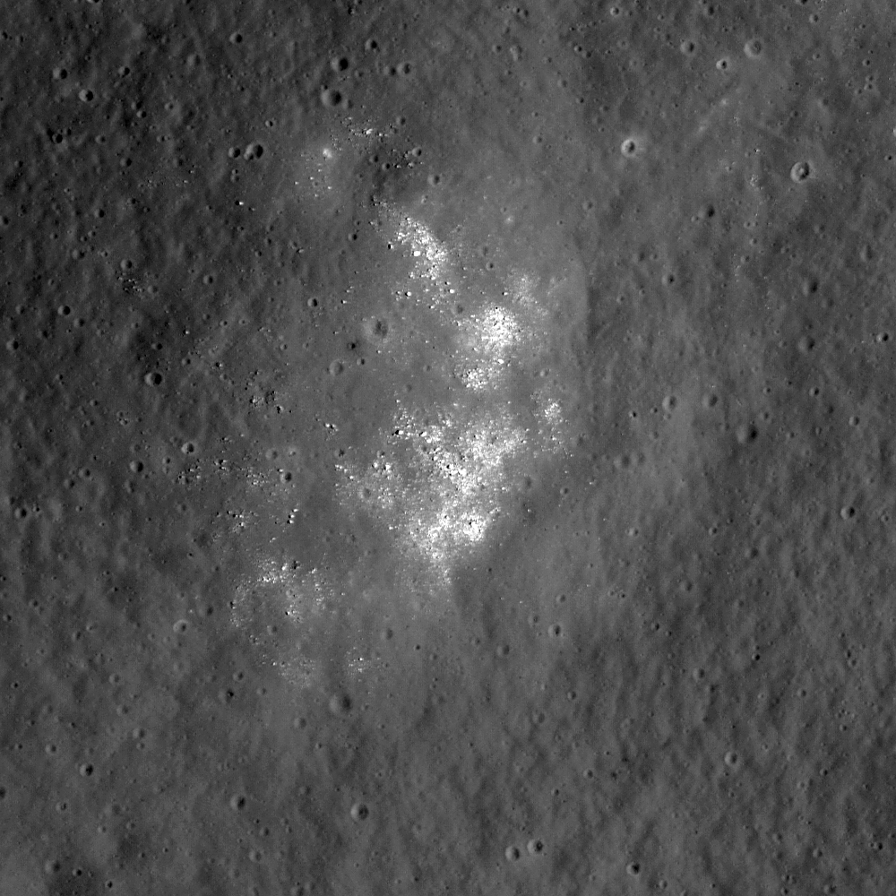
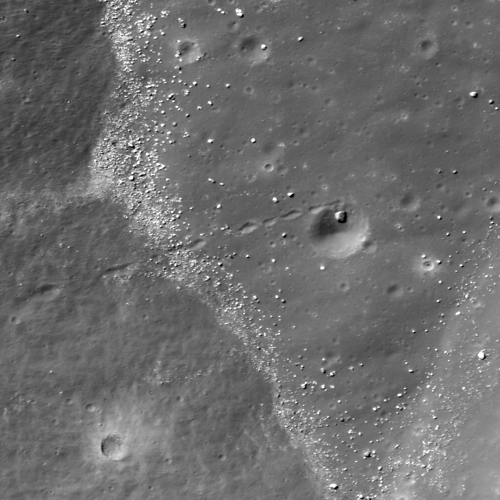
Interior of fresh impact crater in the Smythii Constellation Region of Interest. Portion of image M126371530LE, full scene width = 530 meters [NASA/GSFC/Arizona State University].

Brett Denevi
LROC News System

The featured image shows the interior of a fresh impact crater (approximately 300 meters in diameter) within the Mare Smythii Constellation Region of Interest (ROI).

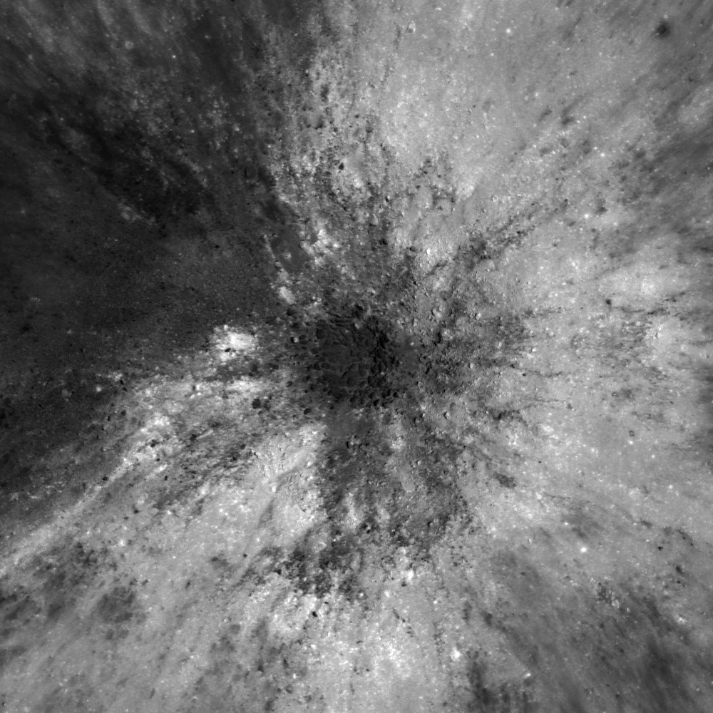
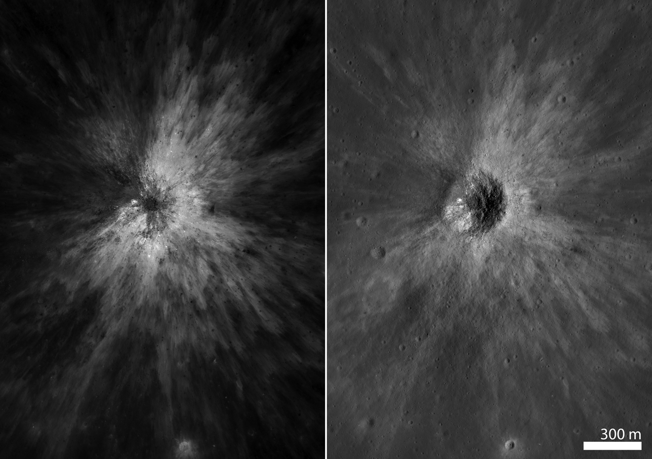
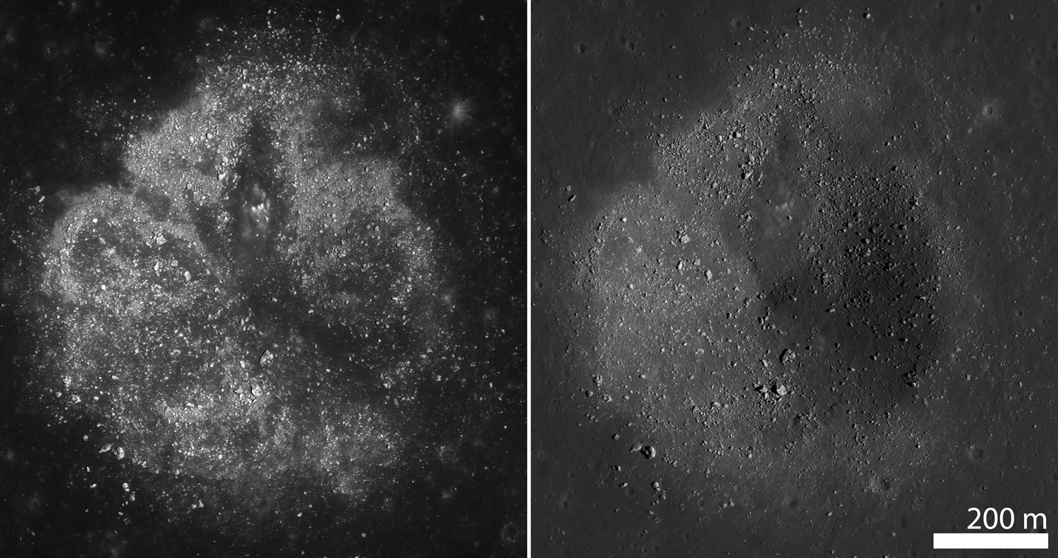
The high-sun image (set atop a closer, full-sized look at the dark, fractured melt on the crater floor) above, it's hard to recognize topographic features because there are no shadows. Wider views following below are paired with lower-sun images of this same crater (on the right, in the thumbnail, which is then followed by cropped vertical comparisons from the full sized image) give sharper views of small scale features, such as boulders.


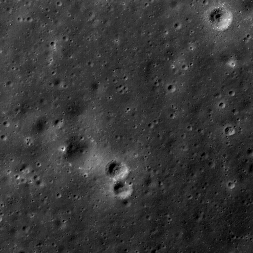
A wider view of the same fresh crater under high-sun (above, LROC M126371530LE, solar incidence, Sun-Moon-LRO phase angle = 21°) and lower sun image, with illumination from the east (below, LROC M113392375LE, solar incidence phase angle of 50°) [NASA/GSFC/Arizona State University].


The floor of this small crater looks like a basket of impact-melt covered rocks. Sampling the ejecta would help answer questions about the age of apparently recent impacts such as this one and the processes that cause their fresh rays to fade.


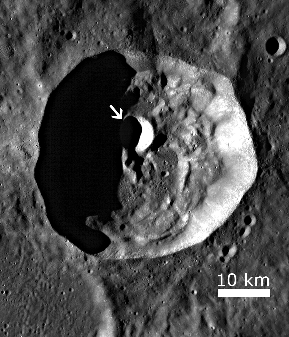
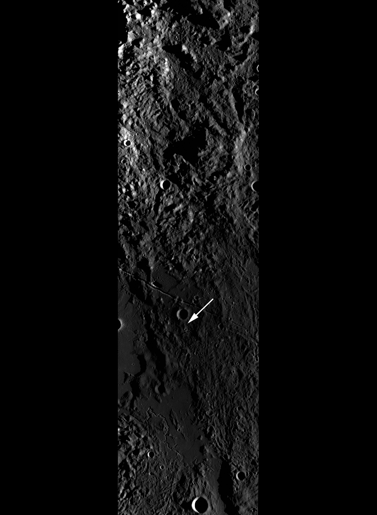
LROC Wide-Angle Camera (WAC) context image of the Mare Smythii Constellation Region of Interest (40 x 40 kilometer box centered on the area), including the eastern portion of 31 kilometer wide Schubert C (1.8°N, 84.6°). The arrow indicates the location of the fresh crater highlighted as the Featured image, above. LROC WAC M115753790CE, LRO orbit 2192, spacecraft altitude 41.21 km., December 18, 2009 [NASA/GSFC/Arizona State University].

Mare Smythii is located on the eastern limb of the Moon and would provide an excellent place to sample relatively young (1-2 billion years old) basaltic lavas not represented among previously collected samples. The western portion of the Region of Interest encompasses the crater Schubert C, the floor of which is fractured, possibly due to intrusions of met from beneath its surface - a great hypothesis for future explorers to assess.


As the terminator sweeps westward relief that highlights elevation with long shadows gradually gives way to a high-sun near the equator, and a different very appearance for the same feature. Farther above is a thumbnail side by side comparison showing low and high illumination of an older south of the one highlighted in the LROC Featured Image. Comparison of conditions May 4, 2010 (when LROC Narrow-Angle Camera M126371530LE was imaged earlier in the local lunar day) is made with November 20, 2009., when LROC NAC M113392375LE was swept up. Under more typical illumination slumps of material and large boulders are revealed as the source of the high and low albedo [NASA/GSFC/Arizona State University].

Mare Smythii contains many beautiful features, several of which are highlighted in high-sun, high albedo images such as the ones shown here. Explore the full NAC image for yourself!

Ed Note: Mr. Denevi also recommends, and we strongly concur, those interested should read more about Smythii Basin in the explanation given for an excellent orbital frame from Apollo 15 (AS15-M-0792), Image of the Week, February 5, 2008, from the Apollo Image Archive also maintained by Arizona State University.

Charles A. Wood, steadfast archivist of the Lunar Picture of the Day (LPOD) website, highlighted an excellent earthside image of the area of the Smythii Basin Constellation ROI, taken by Bart Declercq of Zottgem, Belgium and published as the LPOD on February 25, 2008. In addition to Charles' keen and educated discussion, the image there is a very good illustration of Smythii Basin in relation to Earth-bound observers.

When Mr. Denevi says this area is on the "eastern limb of the Moon," you can see here that's precisely what he means!

The Smythii basin itself, despite the aforementioned, "relatively recent" inundation, is actually dated to the Pre-Imbrium, or older than the "basin-forming impact event" that created Mare Imbrium. Like the Moon itself Smythii Basin is also a time capsule, carrying in its features a very well preserved history of the Moon and that of both the Solar System and that part of the Solar System occupied by Earth.

Thus, Smythii Basin records magnitude, frequency and the characteristics of a long history of conditions at the same "point in space" where the Earth is that unavailable anywhere else. Once again, "to study Earth's Moon is to study Earth itself."


From the United State Geology Service (Astrogeology Program) ever-improving and invaluable "Map-a-Planet" website, two views of Mare Smythii from very different remote sensing. Above is Clementine (1994) Baseline Albedo (v.2) compared below with color-coded lidar topography, in false-color. This demonstrates well yet another way in which the eye is often aided or prevented often from seeing features that might be obvious to blind laser pulse timing, and vice versa [USGS/DOD/NASA].


How about an "anti-MASCON? Highlights from Japan's first lunar orbiter Kaguya (SELENE-1, 2007-2009) were global surveys of the Moon's complex gravity, down to as yet unmatched resolution. Above is Kaguya's simple false color surface elevations, presented in a the form of Smythii Basin in cross-section. Below that, in the very center of the ancient basin, we find the opposite of the kind of mass concentration, or "MASCON" we've long been accustomed to within basins like Mare Imbrium, for example. Standing on the rim of the Imbrium Basin, for example, while holding out a standard carpenter's plum bob on a string, the weight would very visibly hang at an angle toward the direction of the wide-basin's center. Smythii on the other hand appears to host the opposite an "anti-MASCON," or a local mass density lower than the global average, also at the basin's center (and equally invisible from above). [JAXA/SELENE].

Thursday, May 20, 2010

LROC: Hole in One within Hole in One


A house-sized boulder (10 m diameter) rolled down-hill, scoring a "hole in one" and coming to rest within a crater approximately 60 meters in diameter. Portion of LROC NAC M122597190L). Featured Image width = 500 meters [NASA/GSFC/Arizona State University].

Lillian Ostrach
LROC News System

Golf-enthusiasts might look at today's image and say, "Wow, that boulder sure looks like a hole in one!" Boulders like this are incredible because we can determine where the boulder came from by back-tracking along the boulder trail. In fact, Apollo 17 Astronauts Schmitt & Cernan sampled a large boulder at Station 6, and because scientists were able to trace the original position of this boulder using its boulder trail, we can infer what the composition of the rocks up-slope may be.

In this case, the boulder trail curves abruptly as the boulder approached its final resting place. What might have caused this boulder to deviate from its straight, downward course? You can see the boulder trail intersects a crater rim as the local slope was flattening out. As the boulder was slowing, it encountered a new steep slope on its right, thus turning it into the crater.

Boulders fall from high elevations to lower ones because of gravity after being knocked loose by small impacts or moonquakes. Changes in slope can stop boulders; when a steep slope (like that of a crater wall) suddenly shallows, the boulder may not have enough inertia to continue moving. Inertia, or Newton's First Law of Motion, describes an object's resistance to change in velocity. So, a boulder will continue to move until something changes its speed or direction.

Explore and Zoom-In on the full LROC Narrow-Angle Camera frame, HERE.


LROC Wide-Angle Camera monochrome context image of complex 42 kilometer-wide crater Henry Frères (23.5°S, 301.1°E), with a smaller ~7 km diameter crater superposed on its floor (arrow). The floor of this smaller crater is highlighted in today's LROC Featured Image (top). (M117880746ME, covering a field 55 km across) [NASA/GSFC/Arizona State University].

Feingold seeks early end to Constellation

Until national space policy is amended by Congress, perhaps with a budget for the next fiscal year which begins October 1, previously approved and funded work on the Constellation program will continue. While the administration has announced plans that include ending Constellation and terminating work underway for manned lunar exploration, Congress will ultimately determine the future of national space policy.

Leaders for Democrat Party majorities in both the U.S. House and Senate have no plans to begin work on next year's budget until after congressional elections on November 2.

Because the current fiscal year ends a month earlier, temporary spending plans will most likely be approved to bridge gaps in comprehensive budget authority. A "lame duck" Congress, after November's election, with it's present membership intact and still in session between the election and the inauguration of the next Congress in January, might be unable to agree on spending authority and priorities for all or part of the federal government.

Even if, after the election, the present Congress is able to agree on a FY 2011 spending plan, adjustments and even complete reversals of its best laid plans might be implemented almost immediately after the next Congress is seated in January. These scenarios are especially more likely if the make-up of the next Congress is dramatically different, having been changed by the voters in November.

Obviously, putting a permanent axe to Constellation and present work underway to return humans to the Moon (including the "Armstrong National Laboratory" as the American part of a permanent international station at the lunar south pole) would be harder for a new Congress to reverse if this work that is still in progress is terminated sooner rather than later.

All of which might explain why Senator Russ Feingold (D-Wisconsin) is seeking to short circuit any return to the Moon by quietly amending unrelated legislation. Proponents of Constellation are also running committee amendments to unrelated legislation in hopes of reiterating the present national space policy.

For more, Mark Whittington of Associated Content has more details, along with further speculation about Senator Feingold's motivations for amending Senate Bill 3356, HERE.

Wednesday, May 19, 2010

LROC: Rima Bode Constellation ROI


LROC Narrow-Angle Camera closeup of a small fresh crater (230 m across) with very dark ejecta within the regional pyroclastic deposit in the highlands near Rima Bode II. This site is near a NASA Constellation region of interest. This crater has excavated fresh pyroclastic material but has not penetrated through the deposit, which may be more than 100 meters thick in this area. LROC NAC image M124593116L. View is 478 meters across [NASA/GSFC/Arizona State University].

Lisa Gaddis
LROC News System

The Moon is an ancient body.

Its surface is dominated by the ancient highland crust peppered with huge basins, some of which are filled by mare deposits. These mare basalt deposits range in age from 2-4 billion years old. Many millions of years of bombardment by planetary bodies of all sizes have created a thick soil layer (called the "regolith" by lunar scientists) that has been broken up, churned, and homogenized vertically all across the lunar surface. To get past this material and see what’s underneath, you have to look for a 'fresh’ surface on the Moon---perhaps a steep slope or a spot that has been uncovered by a relatively recent impact crater formation event. Such fresh material may hold the best answers to fundamental questions about the geology of the Moon. What are the compositions and distribution of underlying rocks, how old are they, how did they form, and what can they tell us about internal processes of the Moon such as volcanism and tectonism? These questions aren't just important to understanding the Moon, but are also pivotal for understanding all of the terrestrial planets, including the Earth.


Uncontrolled LROC Wide Angle Camera monochrome context image showing the Rima Bode region and southern Montes Appeninus. Approximate position of today's LROC Featured Image is highlighted by a white arrow. Original Context for LROC Featured Image width is 90 km [NASA/GSFC/Arizona State University].


To look for answers to these questions, scientists study ‘fresh’ craters -- those with a crisp rim and an obvious ejecta deposit -- such as the one shown in NAC image, situated within the thick, dark, pyroclastic blanket near the Rima Bode II rille. With the sun nearly directly overhead in this view (solar incidence is ~11 degrees, where 0 degrees is ‘noon’), shadows are few. This crater, which is 230 meters across, and excavated from 10 to 20 m down, has not penetrated through the pyroclastic deposit, so the pyroclastic materials are at least 10 m (or more) thick in this area. The rubble and boulders visible in the crater floor suggest that the crater has excavated a solid, rocky surface beneath the mantle. The presence of a very small (~1 m across), bright crater in the floor may indicate that the underlying highlands material is not far below the floor of this crater.

The Rima Bode region (13° N, 356° E) is (in part) a Constellation program region of interest because of the presence of this thick layer of extremely dark volcanic material. Known as the Rima Bode pyroclastic deposit, it overlies and mantles an extensive portion of the highlands between the mare basalts in Sinus Aestuum and Mare Vaporum, south of the Apollo 15 landing site. As noted by scientists shortly after the Apollo missions prematurely ended, there are several such ‘black spots’ on the Moon, including the material sampled by the Apollo 17 astronauts during their adventure in the Taurus-Littrow Valley. These extremely dark volcanic deposits were thought to be young (possibly within the last several hundred millions of years) prior to the Apollo 17 mission based on photogeologic mapping. However, photogeology can only get you so far. Eventually, you need to send human explorers to fully understand these sorts of problems. Subsequent radiometric age dating of the returned Apollo 17 pyroclastic samples indicated a far more ancient age of ~3.5 billion years. The ‘black spot’ deposits all have rock-free surfaces with remarkably similar properties and are believed to contain the same kind of orange glass and black crystallized spheres as those sampled by the Apollo 17 crew. These particles are the lunar version of ash or cinder, and they are thought to be explosively emplaced on the Moon just as they are on Earth. Rather than forming cinder cones, the lower gravity and near-vacuum of the Moon's environment allows the particles to travel farther up and out from a vent, depositing an extensive blanket of glassy material. The beads have trapped hydrogen and Helium-3 from the solar wind, and enrichments of volatile elements such as sulfur and fluorine have been measured on their surfaces. The pyroclastic materials are also rich in iron and titanium, making them an immensely important as resources for future lunar explorers.

Explore the full resolution NAC image!

For more information, read: Pieters, C.M., T. B. McCord, S. Zisk and J.B. Adams, 1973, Lunar black spots and nature of the Apollo 17 landing area, J. Geophys. Research, 78:26, 5867-5875.


Coregistered Lunar Orbiter mosaic (LO-IV 109H2) and Clementine color-ratio (R=750/415, G=750/950, B=415/750) mosaics of the Rima Bode region of the Moon. The pyroclastic deposit at Rima Bode is the bluish purple unit that covers the highlands. The white arrows marks the location of the small crater shown in the portion of NAC frame M124593116L. Crater Bode A at lower right is 12 km in diameter. The projection is Simple Cylindrical, north is toward the top.

Tuesday, May 18, 2010

The Launch & Commissioning of the Lunar Reconnaissance Orbiter


Screen shot from Goddard Space Flight Center's "LRO Cam," June 22, 2009. As highly anticipated and anxiously awaited as the Lunar Reconnaissance Orbiter was, it's difficult to believe almost a year has passed since it's arrival in lunar orbit. As of May 18, 2010, LRO has orbited the Moon more than 4,120 times [NASA/GSFC].

Neerav Shah, Philip Calhoun,
Joseph Garrick & Oscar Hsu
Attitude Control Systems Engineering Branch
NASA Goddard Space Flight Center

James Simpson
Hubble Space Telescope Project Office
NASA Goddard Space Flight Center


The Lunar Reconnaissance Orbiter (LRO) launched on June 18, 2009 from the Cape Canaveral Air Force Station. LRO, designed, built, and operated by the National Aeronautics and Space Administration (NASA) Goddard Space Flight Center in Greenbelt, MD, is gathering crucial data on the lunar environment that will help astronauts prepare for long-duration lunar expeditions.

To date, the Guidance, Navigation and Control (GN&C) subsystem has operated nominally and met all requirements. However, during the early phase of the mission, the GN&C Team encountered some anomalies. These events offered invaluable insight to better understand the performance of the system. Following an overview of the GN&C subsystem will be a mission timeline and interesting flight performance and accounts of the anomalies encountered by the GN&C Team, discussed in chronological order.

INTRODUCTION

NASA's LRO was launched on June 18, 2009 from the Cape Canaveral Air Force Station, aboard an Atlas V and into a direct insertion trajectory to the Moon


Schematic of an inflight attitude profile of LRO.

Designed, built, and operated by NASA GSFC, the half-billion dollar LRO, delivered on time and below budget, is presently gathering crucial data on the lunar environment in preparation for long-duration lunar expeditions.

The mission, with a nominal one-year duration, utilizes a complement of seven scientific instruments to find safe landing sites, locate potential resources, characterize the radiation environment, and test new technologies.

From launch and early cruise operations through commissioning and into its one year mission, LRO has performed very well, with all subsystems operating well within the bounds of design requirements, collecting excellent science data. An early mission highlight was the release of images taken by the LRO Camera (LROC) Narrow Angle Camera (NAC) of Apollo and Luna landing sites, showing detailed images of landing hardware and the faint but unmistakable footprints left by United States astronauts.

This paper begins with an overview of the GN&C subsystem and a discussion of the LRO mission timeline. An early mission chronological narrative follows, describing GN&C subsystem performance and interesting GN&C events (including some unexpected safe mode entries) that occurred over a period from separation to cruise to lunar orbit insertion and the spacecraft commissioning phase.

Read the full Adobe Reader file, HERE.
(Preprint) AAS 10-085

Monday, May 17, 2010

Global Lunar Conference and an "International Robot Village" on the Moon


The International Astronautical Federation (IAF), the International Lunar Exploration Working Group (ILEWG), the Chinese Astronautics Society and others are preparing to host the Global Lunar Conference in Beijing, May 31 - June 3, 1010.

Global Lunar Conference
11th ILEWG Conference on Exploration
and Utilisation of the Moon:

Representatives of the world's space agencies gather at the Global Lunar Congress with a new sense of mission, a result of recent news that there is water on the Moon. A popular concept of the 2004-2005 era, an international robot village on the Moon, is on the agenda, along with other ideas that prevailed before interest in returning Man to the Moon began losing ground to other space objectives. Host China can be expected to present a status report on its Chang’e 3-stage lunar mission.

The international robot village is described as an array of cooperating lunar landers by 2014 that prepares the ground for an "effective, affordable human lunar exploration and permanent presence by 2024."

The Chinese mission will culminate with the launch and landing of a rover on the moon to collect mineral samples in 2012. China became only the third nation, after the United States and Russia, to send a manned spacecraft into orbit. In September, the country’s space scientists announced they have completed the world’s highest-resolution three-dimensional map of the Moon.

The joint organizers of the congress, the Chinese Society of Astronautics and the International Astronautical Federation, argue that lunar missions will lead to new understanding of the origin and the development of the Solar System, opening "new avenues towards a utilisation of lunar resources that could be used in both the exploration of outer space and here on planet Earth."
For further information, the official conference website is here.