Tuesday, December 31, 2013

Chang'e-3 lander and Yutu rover from LRO

LROC view of Chang'e 3
LROC Narrow Angle Camera (NAC) view of the Chang'e 3 lander and Yutu (Jade Rabbit) rover just before local sunset on their first lunar day of exploring Mare Imbrium. LROC NAC M1142582775R, image field of view 576 meters [NASA/GSFC/Arizona State University].
Mark Robinson
Principal Investigator
Lunar Reconnaissance Orbiter Camera
Arizona State University

Chang'e 3 landed on Mare Imbrium (Sea of Rains) just east of a 450 m diameter impact crater on 14 December 2013. Soon after landing, a small rover named Yutu (Jade Rabbit) was deployed and took its first tentative drive onto the airless regolith. At the time of the landing LRO's orbit was far from the landing site so images of the landing were not possible. Ten days later on 24 December, LRO approached the landing site, and LROC was able to acquire a series of six LROC Narrow Angle Camera (NAC) image pairs during the next 36 hours (19 orbits).
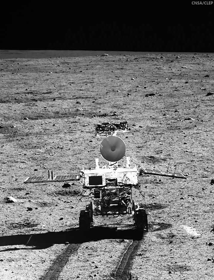
YuTu Rover (58762-717x940)
Yutu in a monochrome still captured from the Chang'e-3 lander, already slumbering in preparation for the bristling cold 14 day lunar night [CNSA/CLEP].
The highest resolution image was possible when LRO was nearly overhead on 25 December 03:52:49 UT. At this time LRO was at an altitude of ~150 km above the site, and the pixel size was 150 cm.

LROC NAC before and after images of the Chang'e 3 landing site [NASA/GSFC/Arizona State University].
The rover is only about 150 cm wide, yet it shows up in the NAC images for two reasons: the solar panels are very effective at reflecting light so the rover shows up as two bright pixels, and the Sun is setting thus the rover casts a distinct shadow (as does the lander). Since the rover is close to the size of a pixel, how can we be sure we are seeing the rover and not a comparably sized boulder? Fortuitously, the NAC acquired a "before" image (M1127248516R) of the landing site, with nearly identical lighting, on 30 June 2013. By comparing the before and after landing site images, the LROC team confirmed the position of the lander and rover, and derived accurate map coordinates for the lander (44.1214°N, 340.4884°E, -2640 meters elevation).

Panorama to LROC Narrow Angle CameraNAC
Chang'e 3 lander panorama [Images from CNSA; compiled by Di Lorenzo and Kremer] showing Yutu shortly after it drove down the ramp to the surface. Yellow lines connect craters seen in the panorama and the LROC image (taken at a later date after the rover had moved), red lines indicate approximate field of view of the panorama.
The lander set down about 60 meters east of the rim of a 450 meter diameter impact crater (40 meters deep) on a thick deposit of volcanic materials. A large scale wrinkle ridge (~100 km long, 10 km wide) cuts across the area and was formed as tectonic stress caused the volcanic layers to buckle and break along faults. Wrinkle ridges are common on the Moon, Mercury and Mars.

change3_wac_morph_and_noslew_1000
LROC WAC context mosaic for the Chang'e 3 landing site (large white arrow); small white arrows indicate wrinkle ridge and small black arrows delimit boundary between "red" mare (northeast) and "blue" mare (southwest), image is 100 km wide [NASA/GSFC/Arizona State University].
M177x3C_604nm-anot-58x128-1337x2950
Another LROC Wide Angle Camera mosaic, captured at high incidence, show the extent of the wrinkle ridge in northwest Mare Imbrium. Area swept up during three sequential orbital passes in 2011. See the full-size mosaic HERE [NASA/GSFC/Arizona State University]/
Lunar mare basalts are divided into two main spectral (color) types: "red" and "blue" (blue is perhaps a misnomer, think "less red"). Basalts on the Moon (same on Earth) are composed mainly of two minerals, pyroxene and plagioclase, though olivine and ilmenite can sometimes occur in significant amounts. The presence of ilmenite (FeTiO3) results in lower reflectance and a "less-red" color - thus the blue basalts. The landing site is on a blue mare (higher titanium) thought to be about 3.0 billion years old. The boundary (black arrows in above WAC mosaic) with an older (3.5 billion years) red mare is only 10 km to the north.

WAC Color Chang'e 3
LROC WAC color (689 nm, 415 nm, 321 nm) overlain on WAC sunset black and white image. Note the proximity of the landing site to a contact between red and blue maria [NASA/GSFC/Arizona State University].
A large area LROC WAC topography map of the Imbrium basin and surrounds is available HERE.

Related LROC Featured Images:
Safe on the Surface of the Moon!
A Great Place to Rove!
LROC Coordinates of Robotic Spacecraft - 2013 Update

Chang'e 3: NAC before and after images
LROC NAC observations before and after, animated above [NASA/GSFC/Arizona State University].

Friday, December 20, 2013

Source Vent for Rima Prinz I

Source vent for Rima Prinz I
Newly released LROC Narrow Angle Camera (NAC) Digital Terrain Model (DTM) of Rima Prinz I where it meets source crater Vera (~2 km in diameter). Field of view approximately 7 km across [NASA/GSFC/Arizona State University].
H. Meyer
LROC News System

The Rimae Prinz Region displays a diverse array of features including sinuous rilles, massifs, and flooded craters. Today's Featured Image focuses on a Rima Prinz I, a sinuous rille just north of Prinz crater that originates from a cobra head-shaped depression named Vera.

This distinctive depression is probably the source for the mare materials extruded in Rima Prinz I. This particular rille likely formed during the emplacement of the mare that filled the crater Prinz and flowed around the rim of Prinz for approximately 25 km before taking a sharp turn to the north, perhaps occupying an existing topographic low.

Vera (Source Vent for Rima Prinz I)
In mid to late 2011, LRO was maneuvered in such a way to allow heretofore unprecedented extreme close-ups of the lunar surface, some from within 20 km. The Vera vent crater (26.48°N, 316.34°E) was among these well-positioned areas. This 1880 meter-wide field of view was cropped from a mosaic of both left and right camera frames of LROC NAC observation M168488930LR, orbit 9964, August 20, 2011; 43.79° angle of incidence, resolution 41 centimeters per pixel from 25.43 km [NASA/GSFC/Arizona State University].
The rille then extended for another ~50 km before grading out into Oceanus Procellarum. In Today's Featured Image, it is easy to see Vera's step-like appearance. The higher step represents a an early eruption event that partially filled the vent and froze, creating the flat "ponded" surface. Later another eruption occurred and the center of the original pond collapsed as a new smaller vent opened.

Rima Prinz I, Prinz (ROI)
Vera and Rima Prinz I, apparently spill over the north rim and wall of mare-filled Prinz crater, in a 14 km-wide field of view from LROC NAC mosaic M104805368LR, spacecraft orbit 602, August 13, 2009; resolution 1.47 meters per pixel from 147 km [NASA/GSFC/Arizona State University].
WACcontext_FI_DTM2-580x800
LROC Wide Angle Camera (WAC) context image of the Rima Prinz region, highlighting the highly reflective rays of nearby Aristarchus crater, and showing local features in relation to Prinz (46.13 km, 28.49°N, 315.86°E). Red rectangle denotes area in a newly released NAC DTM, from which the LROC Featured Image released December 19, 2013 was taken, and the yellow box outlines the topography in that Featured Image [NASA/GSFC/Arizona State University].
In the WAC context image above, we can see the concentration of sinuous rilles in the Rimae Prinz Region, these features are indicative of volcanic activity in this region. The rilles were formed over several episodes of volcanic activity, as evidenced by their varying states of degradation and stratigraphic relationships within and between the rilles, including cross-cutting relationships. For example, Rima Prinz I likely formed from at least two episodes of volcanic activity, because a small sinuous channel is carved from within the interior of the larger channel. The smaller inner channel extends much farther than the larger outer channel, a phenomenon also seen in Vallis Schröteri. As Rima Prinz I is connected to Vera, Vallis Schröteri's rilles are also connected to a source depression.

Explore the newly released NAC DTM, HERE.

Related Posts:
Partially flooded crater rim near Rimae Prinz (August 15, 2013)
An observation post on the rim of Posidonius (July 19, 2013)
A Truncated Rille (May 30, 2013)
Meanders in Posidonius (February 5, 2013)
Old Man River (Of Lava) (July 5, 2011)
Rilles as far as the eye can see at Prinz (December 3, 2010)
Rimae Posidonius (December 1, 2010)
Rimae Prinz - Constellation Region of Interest (April 16, 2010)

Wednesday, December 18, 2013

Chang'e-5 lunar sample mission on for 2017

Chang'e-5 ascent stage
A preliminary notional view of the Chang'e-5 ascent stage on departure from the lunar surface. Officials of China's Lunar Exploration Program (CLEP) have confirmed the sample return mission is scheduled for 2017.
Global Times (Beijing) -China has announced the next step in its lunar exploration program will be carried out by a new moon probe, Chang'e-5, expected to launch in 2017.

This follows the successful soft-landing of the Chang'e-3 probe on the lunar surface Saturday evening.

"The research and development of Chang'e-5 is proceeding smoothly at present and we expect it to be finished and ready to launch in 2017," announced Wu Zhijian, spokesman for the State Administration of Science, Technology and Industry for National Defense at a press conference Monday.

The third and final stage of the unmanned missions to sample the lunar surface is expected to be completed by 2020, using the Chang'e-5 and 6 lunar probes, which will be able to return samples to Earth, said Wu.

This is also the last phase of the China Lunar Exploration Program as a part of the National Guideline for Medium and Long-term Plan for Science and Technology Development (2006-20) issued by the State Council in 2006.

China has completed the first two phases of the program, said Wu.

The first phase was achieved when the Chang'e-1 lunar orbiter launched in 2007, while the second phase was marked as complete when the Chang'e-3 lunar probe and its moon rover separated and took photos of each other on the extraterrestrial body on Sunday.

By Monday morning, five of the eight exploratory devices on Chang'e-3 had been put into operation to survey the lunar surface topography and geology, said Zou Yongliao, an engineer from the Chinese Academy of Sciences

M177x3C_604nm-anot-580x800
LROC Wide Angle Camera (WAC) monochrome (604 nm) mosaic of a 35.7 km-wide parcel of the Laplace F - Le Verrier region in north central Mare Imbrium, marking the December 14, 2013 landing site of China's Chang'e-3. From a 200 km-long field of view swept up in three sequential orbits, December 5, 2011; a sunrise angle of incidence of 76° at 61.5 meters resolution, from 44.7 km [NASA/GSFC/Arizona State University].
"The program's third phase will be more difficult because many breakthroughs must be made in key technologies such as lift-off from the moon's surface, sampling encapsulation, rendezvous and docking in lunar orbit, and high-speed Earth re-entry, which are all new to China," said Wu.

The Chang'e-4 probe, which served as a backup for Chang'e-3, will now be used to test the new techniques for the mission's third phase.

Scale model Yutu
Scale model of the six-wheeled robotic moon rover 'Yutu' (Jade Rabbit), without the, by-now familiar, gold foil thermal blankets. Picture taken at the Beijing Aerospace Command and Control Center [Xinhua].
In response to questions of international cooperation concerning lunar exploration, Wu noted that China is always positive in maintaining good cooperation with other regions and organizations. Data collected through the Chang'e-1 and Chang'e-2 probes is accessible to scientists from across the world, according to Wu.

Wu pointed out that China's exploration will follow the consistent aim of the peaceful use of outer space, which will promote new breakthroughs in high-technology development.

"Despite our current progress, China still lags behind space giants like the US and Russia in many aspects. We need to work harder and move faster," Wu said.

A Range of Reactions to the Chang'e-3 Moon Landing

Will China's Moon landing restart the Space Race, in a good way?

Glenn Reynolds of Instapundit hopes so. He writes in USA Today:

    "The 1960s space race between the United States and the old Soviet Union saw rapid progress in space technology. We went from being unable to put people in Earth orbit, to landing men on the moon and returning them safely to earth, repeatedly, in less than a decade. It happened so fast because each nation was afraid the other would get there first.

    "The 1967 Outer Space Treaty, in fact, was basically a deal to throw the contest out. Each nation was more afraid of being beaten than it was, really, anxious to win itself. As soon as the ink on the treaty was dry, space efforts began to dry up, too. That's one reason why no one has had a soft landing on the moon in almost 40 years -- and why it's been 41 years almost to the day since the last man, astronaut Eugene Cernan, stood on the moon.

    "If, like me, you'd like to see a gold rush on the moon -- or, at least, a Helium-3 rush -- then a Chinese claim might be just the thing to get it started."

Read the full column HERE.

Innovations in China's lunar exploration technology

People's Daily Online:

"Chang’e-3 will fill in a blank in lunar research, and our landing technology is superior to that of other countries."

"Yang Yuguang, researcher of the Second Academy of China Aerospace Science & Industry Corporation, said: “It is wrong to suggest that China’s lunar exploration technology is no more than imitation. For example, the US and other countries adopted a simple technique for their first soft landing on the moon: the moon probe enters the lunar trajectory, and where the trajectory meets the moon’s surface, the intersection point is the landing point. Applying reverse-thrust to the engine brings the probe down onto the surface. While straightforward, this is very resource-consuming. Our approach has been to circle the moon and then choose a spot to land. We will therefore have a wide range of choices. Finding a perfect landing spot is crucial, because the lunar probe is unmanned and the time at our disposal is very limited. So we employ advanced technology and instruments such as laser, microwave, and gamma shutdown sensors. Generally speaking, our lunar exploration techniques are both economical and reliable."

Read the full editorial, HERE.

China, Iran, and Santa

Tom Rogan, National Review Online

"While we argued over Santa Claus’s color (white, black, or multicolored?), China roved across the moon. Iran sent a monkey into orbit and returned him safely to earth.

"America, we have a problem. To be sure, it’s easy to look and laugh, “You’re 50 years behind us.” Easy, but ill judged. Such a casual understanding neglects the defining truth here. Ultimately, the Santa–space dichotomy isn’t about technological power, it’s about national purpose. We need to grasp that fact. Fast.

"Consider what these space missions actually mean for the Chinese and the Iranians.

"It’s tempting to look at space monkey “Fargam” and see only “cuteness.” For Americans who see space exploration in the imagery of decades of manned missions, Fargam doesn’t appear all that serious. But Fargam is far more than a PR stuntmonkey. He’s a traveling messenger for the Iranian revolution — “there are no limits to our aspiration.” And in this vein of “aspiration,” Fargam carries a broader scientific purpose. By riding a rocket-launched capsule into space and then achieving a controlled reentry, Fargam has helped advance Iran’s weaponized-missile program. According to the Defense Department, Iranian progress with two-stage missile systems suggests that Iran may have the capability to attack the U.S. mainland by 2015. Alongside Iranian delaying tactics over the implementation of the Geneva “six months” deal, Fargam suddenly seems a little less friendly.

"But still we laugh. China’s moon landing also carries a deeper message. While the Chinese government claims that “Jade Rabbit” is a pure servant of exploration, this isn’t about the benefit of humanity. Consider some recent evidence on earth.

"Over the past few weeks, China has injected new tensions into the East China Sea. Whether in attempting to usurp new territory or in physical threats to U.S. Navy vessels, the Chinese have made clear that they intend to reshape the geostrategic balance of the Pacific. Even then, China’s foreign-policy evolution isn’t a local pursuit; it’s in pursuit of a truly global agenda. From the Americas to Africa to the Middle East, the Politburo Standing Committee is determined to dominate international affairs. Thus arrives the true story of Jade Rabbit — as a metaphor in a broader strategic gambit. The Chinese aren’t interested in matching American power. They seek to surpass it, and we obsess about Santa Claus."
Read the full editorial, HERE.

6 of 8 Chang'e-3 science instruments now active

Students learn about the ongoing Chang'e-3 mission at a primary school in Ganyu, Jiangsu province, on Tuesday. Designers are pleased with the mission's success so far, as experiments have gone more smoothly than expected [Si Wei/China Daily].
Emily Lakdawalla of The Planetary Society has performed a herculean labor, today, pulling together many threads to deliver what might be the best possible description of a "lengthy press briefing by several members of the Chang'e 3 science team," Wednesday.

"I found it to be quite informative," Emily wrote, "not just about the mission but also about attitudes about Chinese space exploration and foreign cooperation. It was useful background for my participation in an hour-long panel discussion on China Radio International's "Today" program."

A link to her detailed summary follows the official China Daily description, below:

Wang Fan
China Daily

Six out of the eight pieces of scientific equipment deployed to the moon with the Chang'e-3 lunar mission have been activated by scientists and are functioning properly, according to scientists working on the mission.

Speaking at a news conference on Tuesday, scientists said that the equipment aboard the Yutu lunar rover and the Chang'e-3 lander had so far been functioning as hoped, despite the unexpectedly rigorous conditions of the lunar environment.

"Except for the alpha particle X-ray spectrometer and the visible and near-infrared imaging spectrometer, the instruments have all been activated and are undergoing tests and adjustments," said Su Yan, deputy designer of the Chang'e-3 ground applications system.

Zhang He, deputy designer of the probe, said though the temperature disparity is greater than scientists had anticipated, all the equipment on the moon is in "perfect" condition, and optical and ultraviolet-imaging experiments are under way.

Scientists with the ground applications system are expecting to receive a colossal quantity of original data from the rover and lander, which have independent channels to send signals, Su said. The earlier Chang'e-1 and Chang'e-2 craft only had one channel each, he said.

The mission's success so far has been a relief to Wu Weiren, chief designer of China's lunar probe program. He said the whole process, including the launch, the soft landing, the separation of the rover and lander and the ongoing experiments, have gone "much smoother" than he had expected.

Read the full article at China Daily, HERE.

Big HT: to Emily Lakdawalla at The Planetary Society, for her well-translated transcription of Wednesday's press conference posted HERE.

Tuesday, December 17, 2013

Rogozin renews call for Russian lunar exploration, base

Luna-Grunt - Rover Configuration
Russia's space program suffered a huge set back to a renewed lunar exploration effort with the loss of the Phobos-Grunt sample return mission in 2011. A joint mission with India designed to ferry the ISRO Chandrayaan-2 lunar rover to the Moon's surface was cancelled and the Grunt standard prototype lander was returned to the drawing board. Above, a 2010 notional view of a Grunt descent stage delivering rover to the Moon [Anatoly Zak/RussianSpaceWeb].
MOSCOW, December 17 (RIA Novosti) – Russia should consider farsighted space projects such as building a manned outpost on the moon, a senior Russian defense official said Tuesday.

“We must formulate practical plans from conceptual projects and fantasies,” said Deputy Prime Minister Dmitry Rogozin, who oversees the defense and space industry.

Rogozin suggested the Russian space agency Roscosmos and the recently launched Future Research Fund (FPI) should work in tandem on developing such projects.

The FPI – patterned on the United States’ Defense Advanced Research Projects Agency – began distributing grants in April to fund farsighted defense projects. The fund will disburse $70 million this year.

“Many organizations are unfortunately stuck in their busy routines and they have no time to stop and think about new projects,” said Rogozin, who made a similar appeal in September last year for a Russian lunar base to reinvigorate the country’s space aspirations.

On Saturday the 140-kilogram Chinese lunar rover Jade Rabbit made the first soft landing of any probe on the moon in nearly four decades. China is the third nation to achieve a soft lunar landing after the US and the Soviet Union.

Related Posts:
A Russian Moon? Dwayne Day, The Space Review (January 28, 2013)
ESA lunar lander axed (November 21, 2012)
Rogozin presses lunar base, Chandrayaan-2 delayed (September 12, 2012)
Soyuz replacement delayed until 2018 - Popovkin (July 19, 2012)
Craters near Lunokhod-1 officially named (July 3, 2012)
Is there money on the Moon?  Joshua E. Keating Foreign Policy (June 21, 2012)
Russian outlines spaceflight plans to 2030 Marcia S. Smith SpacePolicyOnline (April 29, 2012)
Russian Academy plans Lunokhod-3 and 4 (April 9, 2012)
Popovkin: 'To the Moon in Seven Years?' (February 8, 2012)
"Boy, that sure looks like Luna 9!" (December 3, 2011)

New Imbrium crater from impact observed on Earth

LROC Narrow Angle Camera (NAC) before and after images of the same small patch of Mare Imbrium reveal the Marshall 17 March Impact Event, the first time an impact on the Moon observed on Earth in real time has been definitively identified from lunar orbit. The newly-formed crater is 18 meters in diameter [NASA/GSFC/Arizona State University].
Mark Robinson
Principal Investigator
Lunar Reconnaissance Orbiter Camera (LROC)
Arizona State University

The NASA Lunar Impact Monitoring Program monitors the Moon from a dedicated telescope facility at Marshal Space Flight Center for Meteoroid Impacts. Since 2005 the Marshall group recorded over 300 flashes (assumed to be meteoroid impacts), their brightest recorded flash occurred on 17 March 2013 with coordinates 20.6°N, 336.1°E. Since then LRO passed over the flash site and the NAC imaged the surrounding area; a new 18 meter (59 feet) diameter crater was found by comparing images taken before and after the March date.

March 17 crater
Four different NAC images of crater (18 meter diameter) formed on the Moon, 17 March 2013, each scene is 560 meters wide, north is up [NASA/GSFC/Arizona State University].
This is not the first new impact crater the LROC team has found, nor will it be the last! Hundreds of changes to the surface appear in NAC temporal pairs, the LROC team is systematically searching this growing set of before/after images and results were presented at the American Geophysical Union Fall Meeting last week, and more is coming in the near future.

ALaMO - MSFC
Automated Lunar and Meteor Observatory (ALaMO), at NASA Marshall Space Flight Center (MSFC) in Huntsville, Alabama. The facility consists of two observatory domes, a 15 meter tower with a roll-off roof and an operations center with laboratory space [NASA/MSFC].
Revisit a previous LROC post showing new craters on the Moon formed by natural processes. Also note that new craters on the Moon were also formed by spacecraft impacts (Ranger, Apollo SIV-B, GRAIL), see a summary of LROC Featured Images on this topic, HERE.

Monday, December 16, 2013

A new site to explore on the Moon

Yutu on the Moon
The Yutu rover on the Moon [CNSA/CLEP/CCTV].
Paul D. Spudis
Smithsonian Air & Space

The Chang’E 3 spacecraft, carrying the Yutu (Jade Rabbit) surface rover, successfully landed on the Moon December 14.  Despite pre-mission announcements about a planned landing in the “Bay of Rainbows” (Sinus Iridum in the approved Latin nomenclature of the Moon), the spacecraft actually set down in the northern region of the “Sea of Rains” (Mare Imbrium), the far eastern edge of its designated landing box.  Whether by design or fortuitous accident, this site is actually more interesting geologically than the spacecraft’s original destination.

Two major terrain types dominate the Moon’s geology.  The bright, rugged highlands date from the time of crustal formation 4.5 billion years ago and were intensely cratered during the first 600 million years of lunar history.  The younger areas are the dark, smooth maria, made up of iron-rich lava flows.  These lavas began to erupt after the end of the heavy bombardment of the cratered highlands 3.9 billion years ago and continued sporadically for another billion years.  The exact date of cessation of this volcanism is unknown and in fact, is relevant to the geology of the Chang’E 3 landing site.

Chang'e-3 Landing Zone GLD100-Laplace-F
The precise landing zone of China's Chang'e-3, with the Yutu rover deployed, seems to be in the middle of nowhere. From the standpoint of planetary science, however, and the cause of acquiring a better understanding of the formation of the Imbrium basin, the surface and below and very interesting. Pushed LROC WAC GLD100 mosaic (100 meter per pixel resolution) [NASA/GSFC/Arizona State University].
The lavas of Mare Imbrium contain some of the most magnificent lava flow fronts seen on the Moon.  These flow fronts are actually visible in the best telescopic pictures taken from Earth, but are best seen in images taken from lunar orbit.  An overlapping sequence of flows were created by lava erupting from a small vent area over 700 km south of the Chang’E 3 landing site.  These lavas then flowed northward into the central Imbrium basin.  Measurements of the thicknesses and lengths of these flows indicate the effusion of massive amounts of very low viscosity lava, liquids much runnier than typical terrestrial basaltic lavas.  Estimates suggest that the lunar lavas had the viscosity of motor oil at room temperature.  The term “flood lava” is entirely appropriate in this case as the eruption must have been a veritable torrent of fast moving, molten rock.

A15-M-Imbrium-flows-1660
Apollo 15 (Command Module) metric camera captures sunrise-shadow definition of lava flow lobes in the broad expanse of Mare Imbrium, north and west of Mons La Hire and Lambert crater. Chang'e-3 landed at the far northern end of this sequence of lavas, which are relatively young on the lunar scale [NASA/JSC/LPI].
After lunar lava flows erupt and their surfaces are exposed to space, they begin to accumulate impact craters.  We estimate the age of these flows by measuring the density (number per unit area) of impact craters on them and then compare those measured densities to the density of craters on lava flows from which we have collected samples (four of the six Apollo landing sites and two of the three Russian Luna sites).  From this information, we estimate the age of the late Imbrium flows to be between 1 and 2.5 billion years old, which is significantly younger than all of the returned lunar samples, which date from 3.1 to 3.8 billion years ago.  Although still very old by terrestrial standards, these are some of the youngest lavas on the Moon.  Because rates of erosion on the Moon are extremely low, young lava flows still preserve much of their original morphology and this effect may partly account for the preservation of the flow fronts seen in orbital images.

Because these lava flows are so young, the regolith (ground-up, fragmental surface layer of the lava flow – the lunar “soil”) is only a couple of meters thick.  This value is relatively thin when compared with the thickness of the regolith at the Apollo sites (which ranged from 3-4 meters at the young Apollo 12 site up to over 6-8 meters at the old Apollo 11 landing site).  A consequence of a thin regolith is that because the bedrock is close to the surface, small craters can excavate rocks from beneath the soil.  This probably accounts for the blocky nature of the Chang’E 3 landing site; many large rocks are seen in the descent images and a blocky rim crater is evident in the first pan images retuned from the lander (image above at beginning of this post).  As this crater appears to be about 10-12 m in diameter and has clearly dug through the regolith into bedrock, we can infer a regolith thickness here on the order of 2-3 meters.

Chang'e-3 LZ context Imbrium-composite
Mare Imbrium basin, and the  Chang’E 3 landing zone. Top left, LRO Wide Angle Camera (WAC) mosaic; top right, Clementine false-color composite; lower left, Lunar Prospector Th (thorium) elemental abundance; lower right, LRO topographic map. (Click to enlarge) [NASA/LPI].
The Imbrium lavas are not only remarkable for their physical properties but are also compositionally interesting.  They show a very “blue” color in spectral images obtained from Earth, and from Clementine and other spacecraft.  (Note that “blue” in this sense actually means “less red than normal” – all lunar colors are reddish brown.)  The color of the mare flows has been correlated with lava composition; blue mare basalts are mapped where very high-titanium basalts have been collected.  Thus, it is reasonable to infer that the mare lavas of the Chang’E 3 site are rich in titanium.  In addition, this portion of the Moon is anomalously rich in the radioactive element thorium (Th).  Thorium is a trace element that tends to remain in the liquid portion of a magma undergoing crystallization.  Thus, high concentrations of Th indicate the presence of a component that is “late stage,” i.e., one that forms during the last phases of cooling and solidification.

In this case, the Th appears to be carried by the lava itself, a somewhat surprising result, as usually such enrichment in Th would not be expected in mafic (iron-rich) basaltic lava.  This unusual chemistry is probably the result of special circumstances; the lavas here erupted through a highland crust greatly enriched in the component called KREEP, for potassium (K), the rare earth elements (REE) and phosphorus (P).  On the Moon, KREEP is associated with the final phases of crustal formation and is a key substance for our understanding of the formation and evolution of the lunar crust.  The KREEP component in the lavas was probably accomplished through a process called assimilation (where substances with low melting points get melted and included in hot magmas rising to the surface, which partly melt the surrounding rocks).  The Chang’E 3 site appears to include lavas with that history.

One of the experiments aboard the Yutu rover is a ground-penetrating radar (GPR).  This instrument beams radio waves into the surface and listens to echoes off subsurface reflectors (which can be physical or compositional boundaries).  A key thing to look for at this site is evidence for the bedrock/regolith contact (depth of a couple to a few meters), possible contacts between lava flows (depths of a few to tens of meters), and contact of the mare lava fill with the basin floor (depths of hundreds of meters).  In addition, this site is near one of the famous mare wrinkle ridges, those warping structures that deform the smooth mare surface inside basins.  These ridges can be quite complex, involving multiple faults, tearing, scissoring and grinding as rocks fail and deform under the forces of regional compression.  The GPR profiles may capture this complexity if the rover drives over a ridge during its traverse.

The Yutu rover contains both a spectral imager and an alpha-particle X-ray spectrometer.  These instruments will measure the surface mineral and elemental composition for both rocks and soils.  Because the rover will examine several different individual areas during its traverse, we will obtain new “ground truth” data to better understand the meaning of data obtained remotely from orbit.  At a minimum, Yutu will examine the composition of the surface lava flow, which (judging from Clementine color data) appear to be very-high titanium (VHT) basalts.  But because the rover has the ability to approach and examine the ejecta of large craters, we may be able to study rocks excavated from below the surface flows.  Lavas to the north of the landing site are “red” in spectral images, suggesting a lower titanium content, and these lavas presumably underlie the local VHT basalts.  With data from the rover, we might be able to reconstruct the volcanic stratigraphy of this region of the Moon.

Thus we are poised to investigate a new site on the Moon of considerable interest and complexity, one that displays a variety of geological units and processes.  The Chang’E 3 lander and Yutu rover can provide many answers to our questions regarding the geological history of this region of the Moon and about lunar history in general.  That will be a lot to learn over 3 lunar days (one lunar day equals 14 Earth days of light, sandwiched between 14 days of dark).

Originally published December 15, 2013 at his Smithsonian Air & Space blog The Once and Future Moon, Dr. Spudis is a senior staff scientist at the Lunar and Planetary Institute. The opinions expressed are those of the author but are better informed than average.

Sunday, December 15, 2013

HD video of Chang'e-3 descent and landing released


HT: Keith Cowing, NASA Watch, Emily Lakdawalla, The Planetary Society; June Maher, YT.

Tourist Selfies: Yutu and Chang'e pause for pictures

CH-3-U2-lander-580x420

China's state news sources have delivered those promised, mutually-posed images of the Chang'e-3 lunar lander as seen from Yutu, and vice versa. Posted here are screen grabs, twice removed, once through CCTV feed uploaded to YouTube and grabbed again from there. Hopefully we'll have access to something approaching the quality of the originals, one day.

NASA has spoiled us, after all, having learned to pay close attention to public demand for "awesome" photography. It wasn't always the case, of course, for practical and other reasons. 

Those among us old enough to remember waiting for only a few Apollo photographs, eventually printed up in National Geographic six months after the mission, and after that had to wait decades for digital resolutions and a sibilance of a complete catalog, are impatient with delays. 

China has been particularly stingy with mission photography during their on-going Lunar Exploration Program (CLEP), but that's the kind of zero accountability one expects from totalitarian Marxists. It's still true, in China, when you "call Information" you better have some.

Admittedly, Scientists, east and west, are beginning to consider the entertainment and vicarious experiential value of space exploration images. Very little, very nearly after-the-fact thought that was given to this capability back in the Apollo era, when TV cameras weighed as much as a passenger and were twice as temperamental. 

Ironically, the CCD-based video cameras in everyone's cellular phone in the 21st century originated in the first smaller TV cameras sent beyond our atmosphere. There's even a theory, out there, that posits the ignominious end to U.S. manned lunar exploration might have been avoided if more attention had been put into camera work. That's a tough sell, of course, because the modern consumer's camera is dependent on more than one line of technological development, e.g. micro circuitry.

Regardless, those excuses for leaving the good camera home don't hold water any longer. Space exploration requires a very broad funding base and the miracle of the penny tax. So, state apparatchiks, east and west, better learn that lesson. Now, more than ever, the credo is "no pictures, no story," and, of course, "no bucks, no Buck Rogers."

CCTV Yutu rover on the Moon

LRO: Finding Chang'e-3

landing_clean_M102285549La1-1000
In more than four years in lunar orbit, the LRO LROC Narrow Angle Camera (NAC) system has released to the Planetary Data System (PDS) ony a few observations that include the Chang'e-3 landing site. From the earliest of these, acquired July 15, 2009, in only orbit 250 comes this sample of LROC NAC observation M102285549, centered on the area seen in descent images acquired by Chang'e-3 while closing in on the surface of Mare Imbrium. The field of view is 1700 meters, resolution 1.66 meters per pixel, late afternoon angle of incidence 80.85° from 168.17 km [NASA/GSFC/Arizona State University].
Mark Robinson
Principal Investigator
Lunar Reconnaissance Orbiter Camera (LROC)
Arizona State University

Chang'e-3 successfully landed on the Moon on 14 December 2013. The touchdown occurred on the far eastern edge of the commonly reported landing zone (44.12°N, 340.49°E), in the northwestern portion of Mare Imbrium. By correlating features seen in the nested series of Chang'e-3 descent images it appears the spacecraft landed just to the east of a 450 meter diameter crater.

descent_lroc1-3200
Boxes indicate areas in Chang'e-3 descent images. The spacecraft is probably in, or very near, the smallest box. Field of view 4700 meters wide, from LROC NAC M181302794L orbit 11832, January 15, 2012; angle of incidence 71.7° at 1.57 meters resolution, from 158.79 km [NASA/GSFC/ASU/JHUAPL].
The exact landing site will be known when the Chang'e-3 flight team has time to correlate features seen in surface images with orbital images, and tracking data are refined.

sequence
Chang'e-3 descent images used to locate landing site in LROC NAC images [CNSA/CLEP].
LRO will next be above western Mare Imbrium on 24 and 25 December, and LROC will image the Chang'e-3 landing site.

Meanwhile, why not evisit previous LROC posts of other hardware still on the Moon, and check out the LROC Featured Sites, HERE.

Apollo 17, Station 6

Station 6, Apollo 17
Station 6 allowed Apollo 17 astronauts Eugene Cernan and Jack Schmitt to explore a collection of boulders and regolith that represent rocks from the mighty North Massif. Five large boulder fragments lie at the base of a long boulder trail, all from a single boulder that rolled down the hill and broke apart. LROC Narrow Angle Camera (NAC) observation M134991988R, spacecraft orbit 5027, July 28, 2010; angle of incidence 64.66° at 0.5 meters resolution from 43.83 km over 19.19°N, 30.8°E [NASA/GSFC/Arizona State University].
Jeffrey Plescia
LROC News System

The North Massif lies along the northern side of the Taurus-Littrow Valley, the landing site of Apollo 17. Station 6 was visited during the third and final surface EVA of the expedition and of the Apollo program, December 13, 1972, and was intended as a location to collect ancient highland material from the North Massif as well as a dark mantle that locally covers the region.

The sampling station is about 100 meters above the general valley floor elevation of 2560 meters below global mean average. The North Massif rises some 1400 meters above Station 6 and likely formed in a few seconds as the result of the massive impact that created the Serenitatis Basin.

One of the key science goals at Station 6 was to collect impact melt caused by that event. When rock is melted its radiometric clock is reset to time zero, so a sample of impact melt can be age-dated to determine when the basin formed.

Station 6, Apollo 17
Traverse map of the Apollo 17 site. Station 6 is along the base of the North Massif on the north side of the valley and is circled in red [NASA/GSFC/Arizona State University].
At Station 6, five large blocks are clustered together on a surface that slopes toward the valley floor at about 16°. They lie at the end of a 980 m long boulder trail that formed as a single large boulder rolled down the hill. The trail is about 10-12 m wide with a scalloped edge and periodic small transverse ridges. This irregular pattern is the result of the irregular shape of the boulder. The original boulder was probably about 18 x 10 x 6 m. The largest fragment (Block #2) is about 10 m across.

It appears that the rolling ceased when the boulder broke apart and came to the rest in its present location. As the boulder rolled down the hill slope, it pushed up material along the edge of the track forming a berm. A small berm is also visible in front of the largest fragment. An expanded view of the boulders from an LROC image is shown below. Subtle brightness differences are apparent in the largest boulder in the center, and correspond to different rock types (the boulder is a breccia).

Station 6, Apollo 17
The five major blocks at Station 6, and an additional one farther down slope, are clearly visible in LROC NAC M134991788RE, as is the boulder trail above the blocks. Afternoon illumination, sun from the west [NASA/GSFC/Arizona State University].
Pictures taken during the Apollo 17 EVA at Station 6 illustrate the relative size of the boulders; below Jack Schmitt is seen after after sampling the boulders.

Station 6, Apollo 17
Jack Schmitt picking up the gnomon after collecting samples. This view is to the southwest, and the Apollo 17 lunar module stands sentinel in the upper right deep background (AS17-140-21496) [Eugene Cernan/NASA/JSC].
Jack Schmitt put the Apollo 17 lunar module "Challenger" in some perspective, capturing this monochrome shot, through a 500 mm lens, and from over 3 km) from Station 6. From another panorama of EVA images, AS17-139-21203-5 [Harrison Schmitt/NASA/JSC].
A number of samples were collected at Station 6. The illustration below shows the boulder group and a map made during the mission. The map indicates the location of the rock and soil samples as well as the location of the panoramic images.

Station 6, Apollo 17
LROC image of the boulder complex (top); map of the boulder segments and the sample locations (below). North and South Panoramas designate locations where the hand-held panoramic image sequences were captured. The numbers refer to specific Apollo samples [NASA/GSFC/Arizona State University].
Samples from the station include a single drive tube, ten rock samples (3 from the surface, four from block 1, one each from blocks 2, 4, and 5), several sediment samples (3 from between major blocks, one down slope from the blocks, one from the boulder track, and another from on top of block 1), and one rake sample from the ejecta blanket of a small crater to the northwest of the blocks.

Station 6, Apollo 17
Light-colored inclusions in the matrix of one of the boulders (Block 1) (AS17-140-21442) [NASA/JSC].
The boulders consist of clast-bearing impact melts. Despite the color differences, foliation and frequency of vesicles, the boulders consist of a chemically uniform matrix with clasts ranging in size up to about 1 meter in diameter. The clasts consists of rocks across the anorthosite-norite-troctolite suite or their impact-modified derivatives. Simonds (1975) suggested that the matrix is a clast-bearing rock formed by the mechanical mixture of cold, generally little-shocked clasts and superheated impact melt that rapidly quenched to form very-fine subophitic to ophitic crystalline groundmass. These samples have ages of around 3.98 Ga and are interpreted to represent the age of basin-forming event that produced the material, probably the Serenitatis Basin (as discussed in Ryder et al., 1997). However, more recent work suggests that the rocks collected at Station 6 may actually be ejecta from the Imbrium Basin forming event.

Explore the Taurus-Littrow Valley yourself, HERE.

Previous LROC Featured Images RE: Apollo 17:
Oblique view of Taurus Littrow, from the West (December 19, 2012)
Approach To Taurus Littrow Valley (December 11, 2012)
Taurus Littrow Oblique (September 29, 2012)
Question Answered! (July 17, 2012)
Just Another Crater? (December 13, 2011)
Skimming the Moon (September 6, 2011)
Exploring the Apollo 17 Site (October 28, 2009)

China's Jade Rabbit, it's time in the Sun

Yutu on Imbrium
China's "Yutu," the "Jade Rabbit," rolls out onto Mare Imbrium, Sunday, December 14, 2013. Still from master video display in Beijing [CN].
Mike Killian
AmericaSpace.com

Today, exactly 41 years after the last human footprint was made on the moon by Gene Cernan, China became the third nation to touch the lunar surface – joining an exclusive club and earning a round of applause from around the world.

The last lunar landing was performed by the Soviet Union on the Luna 24 sample return mission in 1976, and the United States remains the only country to have ever landed humans on the lunar surface (last human mission to the Moon was NASA’s Apollo 17 in December 1972). 

The mission, named Chang’e 3 after the Chinese goddess of the Moon in ancient myth, is China’s third unmanned lunar mission, but it’s also the first landing – the next step in China’s ambitious Lunar Exploration Program.  Chang’e 1 launched in 2007, and Chang’e 2 launched in 2010. Both missions orbited the Moon and carried out various studies, while also mapping the surface in its entirety, and both missions paved the way for Change’3 to land on the surface.

Chang'e-3 landing site
Another LROC NAC observation of the landing site of China's Chang'e-3 lunar lander and Yutu rover, this opportunity around half a meter per pixel superior in resolution than one noted earlier. The vehicles have separated following the successful landing, December 14, 2013 - the 41st anniversary of the last moonwalk of the Apollo program in 1972. 638 meter-wide field of view from LROC Narrow Angle Camera (NAC) observation M1116664800R, orbit 16786, February 28, 2013; angle of incidence 44.83, resolution 1.1 meter per pixel from 145.32 km over 44.61°N, 340.3°E [NASA/GSFC/Arizona State University].
The mission began two weeks ago today with a picture-perfect liftoff from the country’s Xichang Satellite Launch Center in southwest China.  Chang’e 3 soared skyward into the black of night atop a powerful Long March-3B rocket, and minutes later the Chang’e 3 lunar lander and its six-wheeled rover, named Yutu, or “Jade Rabbit,” separated from the rocket’s third stage while coasting into a beautiful sunrise 300 kilometers over the Pacific Ocean.  From there it was a five-day trip to reach lunar orbit, and a week later for Chang’e 3 to begin its descent.

Read the full article, HERE.

Chang'e-3 Landing Site
A 2318 meter-wide, full-resolution field of view from the same LROC NAC observation, M1116664800R [NASA/GSFC/Arizona State University].

Chang'e-3 Landing Site in Mare Imbrium

Chang'e-3 Landing Site
Landing Site of the Chang'e-3 lunar lander located and marked at the center of a full (1.58 meters per pixel) resolution, 916 meter-wide field of view of the surface of Mare Imbrium. The preliminary official landing site was 44.12°N, 19.51°W, though the location marked was matched with sequential still video returned to Earth by Chang'e-3 during its landing sequence. LROC NAC mosaic M183661683RL, orbit 12162, February 12, 2012; angle of incidence 54.12° from 159.26 kilometers [NASA/GSFC/Arizona State University].
Chang'e-3 Landing Site matched with LROC NAC imagery
3.16 km-wide field of view (2000 x 2000 px.), HERE.
Chang'e-3 Landing Site matched with LROC NAC imagery
6.32 km-wide field of view (4000 x 4000 px.), HERE.

See a second LROC NAC observation of the Chang'e-3 landing site, of slightly better resolution, HERE.

Saturday, December 14, 2013

Jade Rabbit successfully deployed to lunar surface


BEIJING, Dec. 15 (Xinhua) -- China's first moon rover, Yutu, or Jade Rabbit, separated from the lander early on Sunday, several hours after the Chang'e-3 probe soft-landed on the lunar surface.

The six-wheeled rover touched the lunar surface at 4:35 a.m., leaving deep trace on the loose lunar soil. The process was recorded by the camera on the lander and the images were sent to the earth.

The transfer mechanism with Yutu aboard unlocked at 4:06 a.m. with one side reaching the moon's surface, allowing the rover to descend to the surface following a ladder mechanism.

After the separation, the rover and lander will take photos of each other and start their own scientific explorations.

Chang'e-3 landed on the moon's Sinus Iridum, or the Bay of Rainbows, at 9:11 p.m. Saturday, making China the third country in the world to carry out such a rover mission after the United States and former Soviet Union.

In ancient Chinese mythology, Yutu was the white pet rabbit of the lunar goddess Chang'e. The name for the rover was selected following an online poll that collected several million votes from people around the world. 

Chang'e-3 well east of original target

Sequential stills from beneath Chang'e lander show the final moments of descent, and then the first images in the probes's shadow following touch down.
1-580x418
Descent track of Chang'e-3 shown on CCTV, during live coverage of the landing. Chang'e-3 in Mare Iridum between Montes Recti and Le Verrier crater, perhaps 44 km south by southeast of Laplace F crater, or 160 km east by northeast of Laplace A.[CCTV].
Chang'e-3 162 km east of announced target