Showing posts with label Arizona State. Show all posts

Saturday, October 2, 2010

LROC WAC: Rainbows on the Moon


With the Sun exactly overhead, illumination and viewing angles of a LROC WAC observation create a rainbow effect. The Wide Angle Camera on board LRO is turned to record seven distinct wavebands. Here, visible light data of 689 nm wavelength is reproduced in red, 643 nm in green and 604 nm in blue, from observation M109168446CE. The scene above covers ~ 120 kilometers, north and south of the equator, east and west of 12° east longitude; LRO orbit 1222, October 3, 2009 [NASA/GSFC/Arizona State University].

Brett Denevi
LROC News System

In past featured images, we've seen great examples of the huge effect lighting can have on how the lunar surface looks in NAC images. With the color images from LROC's Wide Angle Camera (WAC), the effects can be just as extreme, and the design of the camera can lead to some unusual and scientifically rich observations. This is the case in the image above, where the 689 nm, 643 nm, and 604 nm filters are displayed in red, green, and blue, respectively. This image was acquired as the Sun was exactly overhead, allowing us to observe the "opposition surge". This is a surge in brightness that occurs when the Sun is directly behind the observer because of two effects. First, there are no shadows seen on the surface, because each boulder and grain of soil's shadow is hidden directly beneath it. Second, as the light reflects back to the observer it constructively interferes with itself.


The same scene, under more typical illumination (Sun is 54° from the vertical). 689 nm filter in red, 643 nm filter in green, and 604 nm filter in blue, from observation M129221342C [NASA/GSFC/Arizona State University].

But why does the image above have a rainbow? Because each filter observes different pieces of the ground at different times, it observes the opposition surge at a slightly different time. When the observations from separate filters are combined to a single color image, this shifting bright spot is seen as a rainbow. When we make mosaics to look at color variations on the lunar surface, we use images where the Sun is a bit lower in the sky (around 30° from the vertical) where this extreme effect is no longer seen. But that doesn't mean these images aren't useful - they provide a huge new dataset for studying how light interacts with a particulate surface at different wavelengths. Perhaps an esoteric-sounding field of study, but this data can help us understand the reflectance images and spectra we have of the Moon and other bodies throughout the Solar System.

Thursday, September 30, 2010

The Great Wall of Aristarchus


Four days after First Quarter, as the Moon waxes Full, our first glimpse of Aristarchus and its namesake plateau comes before the ground-hugging terminator officially arrives with true dawn. This LROC WAC monochrome mosaic, swept up during four LRO orbital opportunities (in LRO orbits 2496-2499) January 10, 2010, allows us an overhead look at the High Wall contact, between plateau and mare, the most abrupt, angular transition between Oceanus Procellarum and anywhere around the plateau. As dawn briefly reaches over the horizon to this height the bow-shaped Wall often seems to hover by itself. As the smoky, colorful and wispy patterns here, including the bright inner slopes of Aristarchus proper (r) catch the sun, it's easy to see why this prominent near side landmark is the location most frequently cited for reports of "transient lunar phenomena" (TLP) [NASA/GSFC/Arizona State University].

Additional Reading:
LROC: Aristarchus - Up from the Depths
July 20, 2010

Extensive Copernicus ejecta

Extensive Copernicus ejecta
One of the geologic features that makes Copernicus crater special is its extensive, high-reflectance ejecta rays that extend across nearby mare and superpose (overlap) ejecta from other craters - Copernican ejecta extends more than 500 km from the impact site. In this high-Sun image, albedo differences are enhanced and the arrows indicate several "fingers" of ejecta and the direction of ejecta emplacement (away from Copernicus, which is to the southwest). 470 meter-wide field of view from LROC NAC observation M127050121L, LRO orbit 3857, April 27, 2010, spacecraft and camera slew 11.6° west from nadir, angle of incidence 30.4° at 47 centimeters per pixel resolution from 37.69 km [NASA/GSFC/Arizona State University].
Lillian Ostrach
LROC News System

Check out Wilhelms' Geologic History of the Moon for more information about Copernicus crater and the lunar geologic timescale.

Copernicus context for LROC NAC M127050121LE
LROC Wide Angle Camera (WAC) mosaic of monochrome (689 nm) observations of high illumination incidence angles captured over several sequential orbits in early January 2010. Familiar Copernicus (93 km diameter) is the result, overlaid on the lunar digital elevation model available through the Google Moon (v5) application. The arrow indicates the approximate position of the area shown at high resolution in the LROC Featured Image released September 30, 2010 and the blue boundary outlines the area captured in the LROC NAC observation seen in the corrected format below [NASA/GSFC/Arizona State University].
Copernicus (early LROC WAC color)
LROC Wide Angle Camera (WAC) visible to ultra-violet portrait of Copernicus in a 458 km-wide field of view, showing some degree of the extensive ejecta of the familiar Copernicus impact, a benchmark for dating lunar stratigraphy. LROC Featured Image, illustrating the post on that very subject written by principal investigator Mark Robinson, March 20, 2012 [NASA/GSFC/Arizona State University].
Discover the Copernicus ejecta deposits for yourself in the full LROC (corrected) Narrow Angle Camera frame, HERE.

Related Posts:
Central Peak of Copernicus Crater

Tuesday, September 28, 2010

Lunar South Pole WAC mosaic


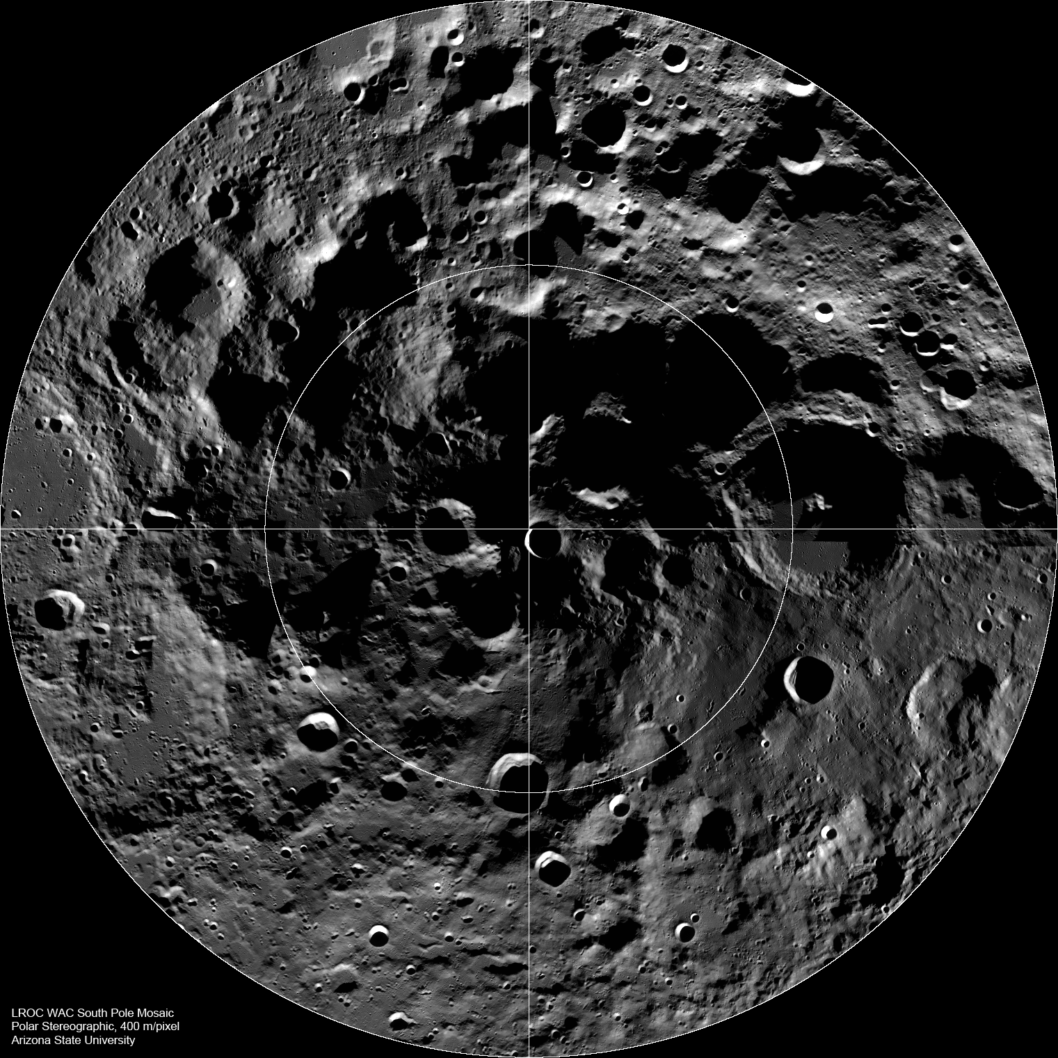
LROC Wide Angle Camera (WAC) mosaic of the lunar South Pole region, width ~600 km [NASA/GSFC/Arizona State University].

Mark Robinson
Principal Investigator
Lunar Reconnaissance Orbiter Camera
Arizona State University


The lunar South Pole is one of the most compelling places in the entire Solar System. This region of the Moon is important for both lunar scientists and engineers planning future human exploration. The towering massifs of the South Pole-Aitken Basin can be accessed, and these massifs contain impact melt that will allow scientists to unambiguously determine the age of this huge basin. Furthermore, permanently shadowed craters may harbor reservoirs of ices and other volatile compounds that could serve as a tremendously valuable resource for future explorers. Additionally, these volatile deposits could contain a priceless record of water composition dating back to the beginning of our Solar System, an incomparable dataset for astrobiology investigations. Finally, a few mountain peaks near the pole (just west and east of the rim Shackleton crater) are illuminated for extended periods of time, providing the near-constant solar power that would be required for the economical operation of a permanent lunar outpost.


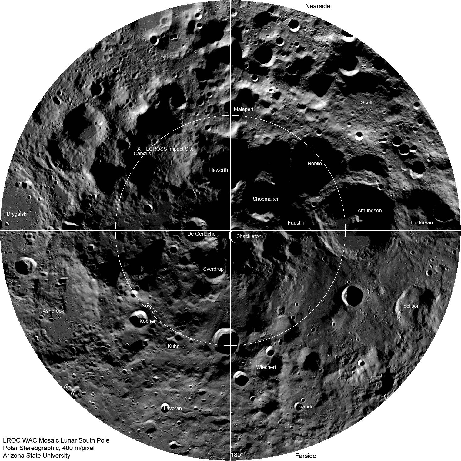
LROC Wide Angle Camera South Pole mosaic showing locations of major craters. The impact site of the LCROSS spacecraft is marked with an "X". Full Mosaic width is ~600 km [NASA/GSFC/Arizona State University].

As LRO passes over the pole every two hours, the LROC WAC snaps an image, and over a month, images covering the entire polar region are captured (80°S to 90°S). This mosaic contains 288 images taken in one month; you can see where the month began and ended at about 90°E longitude (note how the lighting changed). The rim of Shackleton crater seems to be disjointed. However, if you look closely, you can see that the Sun came from opposite sides for portions of the mosaic, resulting in opposite sides of the crater's wall being illuminated in some images. As the mission progresses, the WAC captures the pole across the full range of seasons. More mosaics of the poles will be posted in the future.

Thursday, September 23, 2010

Optically immature ("low OMAT") lunar surfaces


This crater in the floor of Van de Graaff has a high reflectance ejecta blanket compared to the surrounding low reflectance material. The contrast in albedo is due to the crater excavating "fresh" or "immature" material from underneath the surface. Next image field of view is 650 meters. LROC Narrow Angle Camera image M110472904R; 30° incidence angle [NASA/GSFC/Arizona State University].

- Sarah Braden
LROC News System


Ed. Note: Zooming in upon the LROC Narrow Angle Camera observation (M110472904R) affords up an opportunity to see what some have theorize to be two very different kinds of "optically immature" lunar surfaces, areas with "low OMAT." The higher albedo of rough material excavated by the subject crater is particularly highlighted in having apparently occurred directly in a dark lane, bifurcating brighter "swirl" patterns often coincident with local crustal magnetic anomalies on the Moon. In 900 million years the crater's fresh ejecta will have become reddened, darkened into the darker background. Meanwhile the surfaces inside the influence of the local magnetic field lines might well be little changed. Though such fields give no protection against micrometeorites or galactic cosmic rays, they have been shown elsewhere on the Moon to be intense enough to form mini-magnetospheres, deflecting the ever-present solar wind. LROC NAC observation swept up in LRO orbit 1414, October 18, 2009 [NASA/GSFC/Arizona State University].

Browse the full-resolution NAC image in our LROC Image Gallery!

Related posts:

Crater wall in Van de Graaff Constellation ROI
Ejecta from Van de Graaff Crater

Saturday, September 18, 2010

The deepest spot on the Moon nearly wasn't


The 10 km crater at bottom center, home of the Moon's lowest mean elevation (-9,020 meters - JAXA/SELENE, 2008 ) appears to have once nearly disappeared. Even though it's high in latitude, at 70 degrees south, it is not close enough to the pole to be permanently shadowed. It's a fairly normal crater for it's size, generally too small for a central peak with a rubble-lined middle interior and steep sloping inner rim. It's outer rim, however, disappeared one day, as it's host-crater's deep interior flooded with lava. LROC Wide Angle Camera observation M118639861M, LRO orbit 2617, January 20, 2010; alt. 53.95, res. 76.145, phase angle 85.12. Field of view = 32.3 km [NASA/GSFC/Arizona State University].

Not that anyone on Earth would have noticed. This "high-water" mark of molten lava, in this case probably oozing up from underground, was tucked away on the Moon's far side. If the "Man in the Moon" were a real face, the crater where the event took place was on the nape of the neck, where the spine meets the skull. In fact, because all the astronauts who ever visited there orbited much closer to the Moon's equator, no one has yet really seen this spot. Not that we haven't visited by proxy, plenty of times, since the Soviet Union managed to return the first photographs of the Moon's far side in 1959.

On Earth, multicellular life forms may have taken form by then. The raft of the melt that began flooding the host crater, 143 km Antoniadi (69.7°S, 188°E), came very close to spilling over it's north rim before it cooled. Because this flood event almost certainly happened long after after the formation of Antoniadi itself suggests it arose from the depths below Antoniadi, perhaps in the transfer of tremendous kinetic energy following the creation of Mare Orientale.

Studies just published, based on data returned from the Lunar Reconnaissance Orbiter, inform us this and the other "ponds" of mare-like material found in many place around there, near the center of the oldest, widest and deepest impact basin on the Moon - South Pole-Aitken (SPA) basin -is not composed of the "pristine magma" of the kind that may have once covered the entire Moon. The Moon's global "Magma Ocean" now appears to have "differentiated" as it cooled even before the basin-forming impact happened that formed SPA around 4 billion years ago, when no life we know of existed on Earth.

With no plate tectonics or the kinds of swift flowing water and wind we generally think of when we think of weather or climate on the Moon, our companion world holds fast to its ancient record of the history of the part of our star system also occupied by Earth. Because our record of the oldest life on Earth is mostly erased, its possible - even likely - that one day the oldest fossil record of life on Earth will be found on "terrestrial meteors" found on the Moon.

Thursday, September 16, 2010

Two major LRO milestones marked by LROC


The recent release of the LROC Wide Angle Camera mosaic of the Moon's eastern hemisphere inspired Moon watchers to pour over a view filled with objects both unfamiliar as well as features that, even if familiar, are impossible to see from the same angle from Earth. On the eastern edge of Mare Australe a feature briefly caught our attention. In the long shadows appeared what seemed to be a classic volcano, around 46.57°S, 113.89°E.


A Third Release of LROC images to the Planetary Data System (PDS), September 16, did not immediately provide any new Narrow Angle Camera observations of this "cone's crater," other than previously released close-ups of its high-angled slopes. But two newly Wide Angle Camera views from June 2010 did show the feature, most likely a worn crater perched on what remains of an equally worn ring of mountains surrounding the Australe basin. (Looks like good skiing in Narrow Angle Camera views.) - LROC Observation M130896509M, LRO orbit 4423, June 11, 2010; alt. 54.7 km, resolution 76.68 meters [NASA/GSFC/Arizona State University].

Mark Robinson
Principal Investigator
Lunar Reconnaissance Orbiter Camera
Arizona State University


The LROC Team delivers third archive volume to the PDS, more than 68,000 new images are now available, and September 16 marks the transition of the LRO mission from NASA's Exploration Systems Mission Directorate to NASA's Science Mission Directorate.

LROC Team Releases 3rd EDR and CDR Archive Volume

The third LROC release contains 68,992 EDR products, totaling 8.1 TBytes of images and ancillary files. The majority of the images were taken between March 16, 2010 to June 15, 2010. This release also contains images acquired on the dates: 2010-02-06, 2010-02-24, 2010-02-25, 2010-03-03, 2010-03-04, and 2010-03-05.

The 3rd CDR volume contains 69,091 CDR products, totaling 17.0 TBytes of images and ancillary files. The majority of images were taken between March 16, 2010 to June 15, 2010. There are also images taken on the dates: 2009-06-30 to 2009-12-31, 2010-02-06, 2010-02-24, 2010-02-25, 2010-03-03, 2010-03-04, and 2010-03-05 represented in the volume.

Total number of LROC EDR products released to date: 225,903 for a total 28.2 TBytes of images and ancillary files.

Total number of LROC CDR products released to date: 225,428, for a total of 55 TBytes of images and ancillary files.

Explore the new images on LROC's browse page.

ESMD to SMD Transition

September 16 marks the transition of the LRO mission from NASA's Exploration Systems Mission Directorate (ESMD) to NASA's Science Mission Directorate (SMD). Throughout the first phase of LRO's mission the spacecraft collected vast amounts of science data in support of NASA's exploration goals. The transition simply means that LRO science data will now support NASA's science goals. What does this transition mean in practice? For the most part the transition will be relatively seamless, with only a re-prioritization of special targeted observations. For example, the Constellation Regions of Interest will drop in priority and other high science value targets will have their priority raised.

The bottom line: LRO will continue to collect a bonanza of lunar science data.

NEXT step for ESA's first lunar lander


NEXT, ESA's lunar lander mission, is under development for a landing in the mountainous, heavily cratered terrain near lunar south pole, possibly in 2018. The ‘Phase-B1’ study is going on under the leadership of EADS-Astrium Bremen, where some key technologies will be developed and tested for the first time. The project will be presented to the ESA Ministerial Council in 2012 for final approval [ESA].

BERLIN - Sept. 16. What's being planned as the first soft landing in the Moon's south polar region took a step forward today when a further study contract was signed with EADS-Astrium in Berlin, Germany.

The mission aims to land in the mountainous and heavily cratered terrain of the lunar south pole in 2018. The region may be a prime location for future human explorers because it offers almost continuous sunlight for power and potential access to vital resources such as water-ice.

To reach the surface safely, the lander must precisely navigate its way to a mountain peak or crater rim, carefully avoiding boulders and steep slopes before gently setting down to take in one of the most spectacular views in the Solar System.

The Moon is a favored target for the human exploration missions outlined in the ‘Global Exploration Strategy’ (pdf) by 14 space agencies around the world. The strategy supports international space exploration and calls for further studies of the Moon and Mars – places where humans will one day live and work.

18-month effort begins in Berlin today

The contract was signed by Simonetta Di Pippo, ESA’s Director of Human Spaceflight, and Michael Menking of EADS-Astrium, in the presence of Peter Hintze, Parliamentary State Secretary in the German Federal Ministry of Economics and Technology.

"It is a great pleasure to see progress being made in Europe in the field of space exploration relying on key technologies developed for human spaceflight," affirmed Mrs Di Pippo.

"As we prepare ourselves to join the United States, Russia and Japan in the decision to utilize the International Space Station for 10 more years and beyond," she added, "we are preparing the next steps, and we are working to position Europe at the level of its competences and capabilities within the global exploration undertaking. With a strong and successful presence in low orbit, the Moon is the next natural goal on our common path to further destinations. Europe is actively and successfully present in these global projects, like ISS and exploration, which contribute to affirm our role as a modern, dynamic and innovation-driven continent."

"The proven capabilities of the Automated Transfer Vehicle as a technology demonstration are representative of Astrium’s skills and experience in automated rendezvous and docking procedures," said Dr. Menking, Astrium’s Senior Vice President Orbital Systems and Space Exploration.

"The concept of the new study is based on the technologies of ATV and this unique expertise will enable us to develop the key technologies; it would not be possible to envisage landing a robotic vehicle on the Moon without them."

From a design concept to hardware reality


European Space Agency Next lunar lander breaks a polar orbit a few hundred kilometers past perilune and begins its carefully timed and calculated Terminal Descent to the lunar surface, perhaps in 2018 [ESA].

The start of this ‘Phase-B1’ study is an important milestone because now, after the preliminary planning and feasibility studies, the mission’s design will be continued under the leadership of EADS-Astrium Bremen and some of the key technologies will be developed and tested for the first time.

The robotic lander will be designed down to the level of its various subsystems, such as propulsion and navigation. The contract will culminate in a ‘Preliminary System Requirements Review’ in 2012, which will provide the basis for the final design of the mission and lander.


The bright rim of 10 km-wide Shackleton crater, surrounding its permanently shadowed interior, supports the southern axis of the Moon's rotation. The pole itself presents a very small profile for a landing ellipse for a stationary lander. From "Lunar South Pole: Out of the Shadows," a mosaic of LROC Narrow Angle Camera frames M105824863L & R, LRO orbit 744, August 25, 2009 [NASA/GSFC/Arizona State University].

The Americas from the Moon

Updated September 16, 2010 1953 UT

Earth's Western Hemisphere, "nicely free of clouds," August 9, 2010. High Noon over the U.S. East Coast; the Moon was invisible overhead, a few hours shy of New and transiting just below the Sun in the sky. LROC Narrow Angle Camera observation E136013771 [NASA/GSFC/Arizona State University].

Mark Robinson
Principal Investigator
Lunar Reconnaissance Orbiter Camera
Arizona State University


As LRO orbits the Moon every two hours sending down a stream of science data, it is easy to forget how close the Moon is to the Earth. The average distance between the two heavenly bodies is just 384,399 km (238,854 miles). Check your airline frequent flyer totals, perhaps you have already flown the distance to the Moon and back on a single airline! Contrast the current image with the NAC view taken last June, which revealed much of central Asia.

The Moon is a spectacular sight in the nighttime sky. Now imagine the Earth from the Moon, four times larger, a delicate blue, and it does not rise nor set. To astronauts, the Earth is a constant companion, at least on the nearside. Of course, on the farside you can never see the Earth.


The iconic picture (AS17-134-20384) of Apollo 17 lunar module pilot and geologist Harrison Schmitt, by Capt. Gene Cernan at the beginning of their mission's first EVA, December 11, 1972. View full-resolution, HERE [NASA/ASJ].

The overarching goal of the LRO mission is to obtain the data needed to enable engineers and scientists to design the hardware and instruments to pick up lunar exploration where it was paused after Apollo 17 in December of 1972. LRO has now collected these data, so we are ready to move along the path of returning to the Moon! Will designs for lunar habitats include Earth windows? Certainly a human factor to consider! Are there any adverse psychological effects for future lunar explorers on the farside with no Earth overhead? For now, we are happy to occasionally snap an image of the Earth as the NAC collects routine calibration data.

Examine the NAC view of the Earth at full resolution.

Tuesday, September 14, 2010

Fresh views inside the mare crater pits

Updated September 16, 2010 1958 UT
Spectacular high Sun view of the Mare Tranquillitatis pit crater reveals boulders on an otherwise smooth floor. Image is 200 meters wide, north is up, NAC M126710873R (400 meter-wide original LROC Featured Image, HERE.) [NASA/GSFC/Arizona State University].

Mark Robinson
Principal Investigator
Lunar Reconnaissance Orbiter Camera
Arizona State University


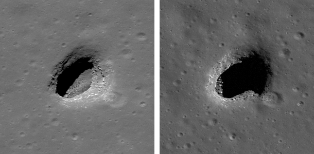
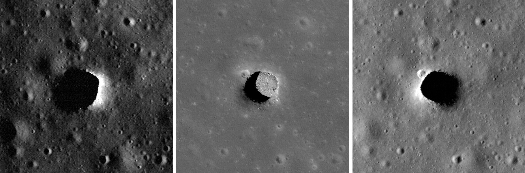
When the Sun is well overhead, the floor of the Mare Tranquillitatis pit is illuminated. With an incidence angle of 26.5° and a shadow of 55 meters, scientists can estimate the depth to be a bit over 100 meters. That estimate is from the edge of the shadow, which begins a slightly downslope from the gradual margin of the pits. When measured from the level of the surrounding mare plain, the depth of the pit is even greater. Compare this depth to the width, which ranges from 105 to 115 meters across the sharp precipice.


Two views of Mare Ingenii pit [NASA/GSFC/Arizona State University].

A pair of Mare Ingenii pit images (each panel is 150 meters wide) reveals different portions of the floor as the Sun crosses from West to East (Left M123485893RE, Right M128202846LE). Shadow measurements indicate that the Ingenii pit is about 70 meters deep and its width is about 120 meters. The Sun angle, direction, and elevation perfectly illuminate the layered nature of the mare basalts. Each shelf corresponds to a local lava flow event. By climbing down this "staircase" a geologist astronaut can sample increasingly further back in time.


Variations in lighting reveal the structure of the fascinating lunar pit craters. The center panel, with the Sun high above, gives scientists a great view of the Marius Hills ("Haruyama") pit interior. Each panel is a 300 meter-wide section of LROC NAC observation; top M133207316LE, center M122584310LE, bottom M114328462RE See original three-panel view, HERE [NASA/GSFC/Arizona State University].

LROC has now imaged the Marius Hills pit three times, each time with very different lighting. The center view has an incidence angle of 25° that illuminates about three-quarters of the floor. The Marius pit is about 34 meters deep and 65 by 90 meters wide. Read more about the Ingenii, Tranquillitatis, and Marius pits.

Do any of these pits provide access to still-open/uncollapsed lava tubes? What could be learned by visiting and exploring one or all of these fascinating features? Imagine entering a preserved lava tube, unchanged for more than 3 billion years; such an opportunity is a geologist's paradise - a chance to travel back in time to see what brand-new lava flows look like! What types of rare minerals might exist on these hidden surfaces (if they exist)? Do you think we should send a robot into one of the pits? How about astronauts; is it worth sending humans in to explore? How would you like to explore this amazing feature?

Search the nearby area for clues in the full LROC NAC frame that may help determine if an extended lava tube system still exists beneath the surface.

Friday, September 10, 2010

Color of the Moon

Updated September 16, 2010 1953 UT

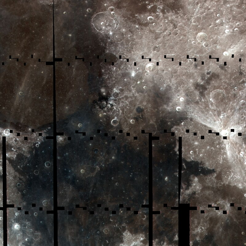
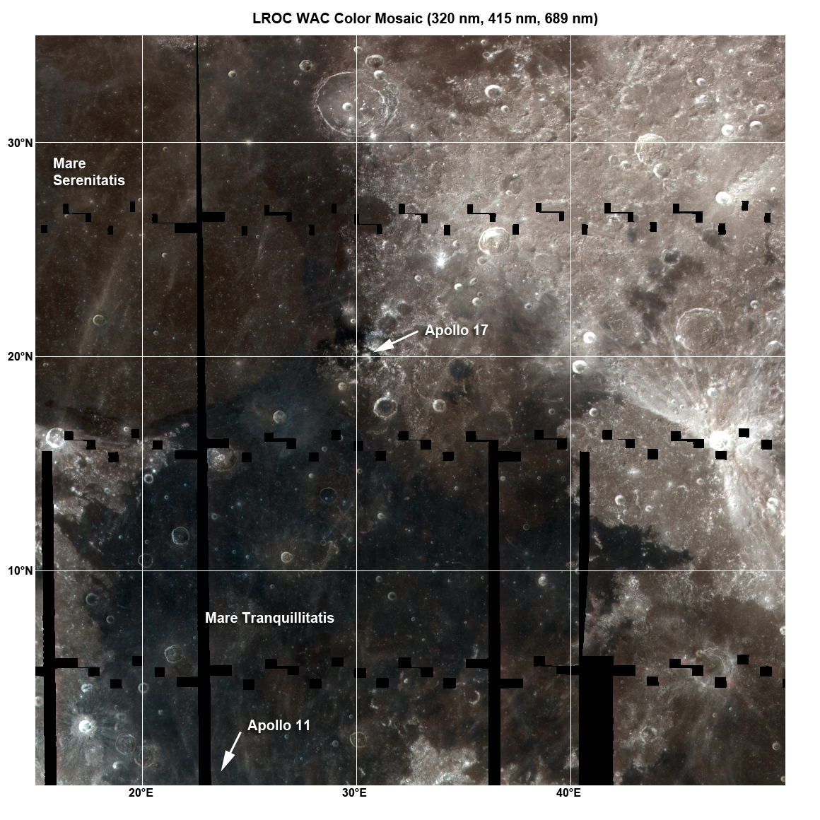
The LROC Wide Angle Camera (WAC) is busily mapping the Moon in 7 Ultra Violet (UV) and visible wavelengths (320 nm through 689 nm). This color composite shows 320 nm light in blue, 415 nm in green and 689 nm in red; scene is ~1000 kilometers wide. (Few full-sized image HERE.) [NASA/GSFC/Arizona State University].

Mark Robinson
Principal Investigator
Lunar Reconnaissance Orbiter Camera
Arizona State University


Colors on the Moon are dominantly controlled by variations in iron and titanium content. The mare regions have low reflectance because they contain relatively high amounts of iron oxide (FeO). Some mare basalts contain unusually high amounts of titanium oxide (TiO2) in addition to iron oxide, making for even lower reflectance. TiO2 also shifts the color of the mare from red to blue.


Color variations on the Moon are subtle (just look at the Moon with your eye). To help distinguish small color variations, the Wide Angle Camera on-board the Lunar Reconnaissance Orbiter divides the UV and visible spectrum into 7 narrow bands. Scientists can pull out subtle signals from the result specific to different minerals on the lunar surface. (View full-sized version of this image, HERE [NASA/GSFC/Arizona State University].

The distinct boundary between Mare Tranquillitatis (darker and bluer) and Mare Serenitatis (lighter brown) is clearly visible in the WAC color image and results from high TiO2 in the Tranquillitatis basalts. Scientists have studied the Tranquillitatis basalts in detail from the rocks returned by the Apollo 11 astronauts; the composition of the Serenitatis rocks are known only from orbital remote sensing. One of the goals of the WAC is to provide a global map of UV and visible reflectance to help scientists better understand the distribution of iron and titanium in the mare. From the Apollo samples, we believe that titanium is dominantly held in the mineral ilmenite. However, we have not sampled the full variety of lunar basalts so we can not be sure - more samples are needed.

Grain size and physical state of the surface material also effect the reflectance (or albedo). Note how the region near the Apollo 17 landing site is anomalously dark. Is this effect simply from extremely high abundances of iron and titanium? Yes and no -- yes, the materials sampled do have high titanium and iron, but no, higher abundances have been sampled at the Apollo 11 site. The big difference is in the physical state of the material. Mixed into the soils in this area is a high percentage of pyroclastic materials (lava that was blown out of a vent and rained down over a wide area). The magma drops cooled in flight and formed little beads of glass and small crystals. These beads had high titanium abundances and are very low in reflectance, giving this area its distinctive dark signature.


The rocks returned from the Apollo 11 and Apollo 12 sites were both dominated by basalt. A key difference between the two sites the abundance of the mineral ilmenite. The elongate black minerals in the Apollo 11 thin section (right) are ilmenite [Arizona State University].

The Apollo 12 samples (e.g. 12017) were generally lacking in ilmenite while the Apollo 11 basalts (10018) had an unusually high percentage. The total weight percent (wt%) of TiO2 in the Apollo 11 rocks exceed 10%. How does this compare with terrestrial basalts? Most have less than 1 wt% TiO2, and a terrestrial basalt with 3 wt% is considered very high. So what is up with the lunar variety? Basalts come from melting of mantle rocks which are squeezed up to the surface. Sampling basalt is a convenient way to sample the mantle! The fact that lunar basalts sometimes have very high titanium tells scientists that the processes that work to segregate elements in the mantle are very complicated; the Moon is not a simple body. Right now the complex history of lunar formation and how its interior evolved are not well understood. By pinpointing areas on the surface that have varying amounts of titanium with the LROC WAC, future mission planners can better plan sampling spots for humans and robots.

The long gores (black areas) in the WAC mosaic are due to off-nadir slews to acquire NAC stereo observations and the small boxy gores are areas not imaged as the WAC resets between images on an orbit. Since the the viewing angle of the WAC changes from straight down at the center to 30° at the edge in color mode (45° in BW mode) the extreme angle at the edges results in geometric distortion and an apparent change in brightness of the surface. Both effects need to be removed to make mosaics, and the LROC team has been working on corrections since this Spring. If you look closely at some the image edges, you can see slight color fringes. This effect is an artifact of imperfect photometric correction. Over time as more WAC data is collected, the science team can better model the lunar photometric properties and provide improved corrections.

Investigate the Mare Tranquillitatis and Mare Serenitatis region in greater detail, HERE.

Pushed natural color, as viewed from Earth:


From "Moon in color," April 6, 2009. Yuri Goryachko, Konstantin Morozov & Mikhail Abgarian, ASTRONOMINSK. Santel-230 (D=230mm, F=3000mm), Unibrain Fire-i 702 CCD camera, mosaic of 51 images; 4200x4600, 7.4MB

King Crater Natural Bridge


About ten kilometers north of the deep 73 km-wide crater King, a 20 meter-long natural bridge near 6.23°N, 119.70°E. has been discovered, surveyed in high-resolution from Lunar Reconnaissance Orbiter (LRO). Impact melt from King's energetic formation was flung up and over this area. Still semi-liquid, cooling unevenly, the flood then rushed back into King's interior, carving a wide notch on the crater rim. This brief chaos blistered and channeled this slope, under the surface. A void, perhaps briefly a subsurface channel, eventually degraded into a pit opening amazingly "bridged" by a uniquely stubborn ceiling. This intriguing lunar feature is well within the King Crater Region of Interest, a Tier One priority target for LRO. Further views and Discussion about this discovery [NASA/GSFC/Arizona State University].

Paul D. Spudis
The Once & Future Moon
Smithsonian Air & Space

The camera aboard NASA’s Lunar Reconnaissance Orbiter spacecraft, currently about to begin its second year of mapping the Moon, continues to reveal new and fascinating details of the geology of the Moon. A recent featured image at the LROC web site shows what appears to be a “natural bridge” on the lunar surface, i.e., an unsupported strip of terrain that connects two topographic prominences. What might this feature be telling us about the Moon’s processes and history?


Four Windows Cave, El Malpais National Monument, New Mexico [DesertMarmot].

Natural bridges are not common on Earth. They typically form by erosion of rock from beneath, in which material is slowly and gradually removed at such a rate that the uppermost surface remains intact. They are found most often on Earth in sedimentary deposits, in which running water erodes rock away from opposite sides of an area, causing the retreat of two scarps that eventually meet, leaving an intact arch or “bridge” that appears to connect two hills. Such a feature is ephemeral, of course; the same erosion that created the bridge will eventually destroy it, leaving at last only two disconnected hills, both of which will eventually be eroded flat themselves over time.

As there is no running water, how can such a feature be made on the Moon? A flowing liquid is involved, but it’s not water. I have discussed the flow of lava in the lunar maria and its production of caves in a previous column. Billions of years ago, lava erupted onto the surface of the Moon. This lava was of very low viscosity (about the consistency of motor oil at room temperature) and it spread out into thin sheets that flowed across the surface very rapidly. As the lava cooled, it solidified from the outside inward, leaving the hottest, most fluid material in the center of the flow. In some cases, this created a lava tube, which is a very efficient method of transporting erupted lava from a vent to a flow margin. Lava tubes can be active for most of the duration of an eruption and when the eruption stops, the lava inside them often drains out, leaving behind an empty, underground tunnel. Sometimes, the roofs of these tunnels collapse, exposing the tube interiors to space through cave “skylights.”


Natural bridge in a terrestrial lava tube, El Malpais National Monument, New Mexico. "Nearby, old lava tubes have collapsed to form narrow steep-walled box canyons (the largest called 'Catepillar Collapse' for its winding path). A small section of a cave roof survived to form this narrow bridge." [DesertMarmot].

It is difficult to understand how caves on the Moon may be preserved for very long periods of time. When drained, the tube roofs are exposed to space and over time, may be hit by impact debris, both meteoroid projectiles from space and secondary debris kicked up by other impacts nearby. This debris will erode and shake the surface and could destroy the tube roofs to the point where they might collapse, filling in the underlying void space. If such a process were incomplete, collapse could create a natural bridge on the Moon, where adjacent segments of a collapsed lava tube roof are still connected by a segment of the roof that has not yet been destroyed (see picture above).

One interesting aspect of the newly found natural bridge is that it does not occur in volcanic terrain, but in the middle of the far side highlands. How can such a feature form here, so far away from the volcanic maria that is found predominantly on the near side? The same processes are at work but the liquid rock here has a different origin. During very large impact events, some of the shock energy of the impacting projectile is dissipated as heat, both vaporizing and melting some of the rocky target. The LROC images have shown us a wealth of features around very young craters that appear to be solidified flows of liquid rock (shock melt from the impact event). In the case of this natural bridge, it is found in a smooth pool of impact melt that was formed when the 70 km diameter crater King was formed. King is a very young crater in lunar terms, probably having formed no more than a few hundred million years ago. This is extremely old by Earth standards, but on the Moon – with its extremely low rates of erosion – it is part of the Copernican time system, which encompasses events that occurred within the last one billion years of lunar history. King is probably slightly younger than the crater Copernicus and to look at its rim in the high resolution images from LROC, one sees a myriad of fresh, crisp features that look liked they formed only a few days ago.

The natural bridge found near King crater probably formed when a large pool of shock liquid rock cooled enough to roof over, creating a solid surface crust. Downhill draining of the melt pond removed the liquid from beneath this crust, weakening the surface and causing its collapse in some places. The natural bridge is actually just a zone of preserved surface crust that occurs between two adjacent collapse pits. As with natural bridges on the Earth, this bridge is transient; the constant bombardment of the lunar surface will grind away the bridge through erosion by impact, which is extremely slow (erosion rates on the order of one millimeter per 20 million years.) Eventually, both surface grinding and shaking during impacts will cause the collapse of this feature. However, this won’t happen anytime soon, so you have several tens of millions of years to see it.

Closer look at the King crater natural bridge


Stretched "3D" close-up of the 20 meter natural bridge over a far side lunar pit discovered by the Lunar Reconnaissance Orbiter Camera (LROC) team at Arizona State University. The bridge's shadow cast on the pit floor is visible in the west opening [NASA/GSFC/Arizona State University].


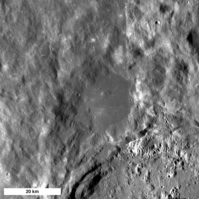
The view over "King Y," the 17 km-wide impact-melt flooded depression northwest of 72 km King (5°N, 120.5°E). The interior and western rim of the larger complex crater is on the horizon. 10 km north of King the natural bridge is seen huddled in the blistered melt sheet. Flow patterns from the King impact event hint at the forces briefly at work here, and quickly fossilized, hundreds of millions of years ago.

Discovering a Natural Bridge on the Moon


Credited as the first view of the natural bridge discovered in high-resolution surveys of the King Crater Constellation Region of interest (ROI). This 400 x 400 pixel segment, cropped from a 5064 x 52224 pixel Narrow Angle Camera (NAC) strip was swept up early in the Lunar Reconnaissance Orbiter (LRO) mission, August 1, 2009. The vehicle was slewed -6.09° to image the King ROI target, 118.57 kilometers over the Moon. The field of view is approximately 480 meters. LROC NAC observation M103725084L, orbit 451 (Res. 1.22 m, Sun-Moon-LRO phase angle 68.74°) [NASA/GSFC/Arizona State University].


The subsequent orbit (LRO orbit 452) over King brought cameras nearer to being directly over the natural bridge, and this slightly better view was captured, again on August 1, 2009, from 118.72 kilometers. The field of view is approximately 480 meters. LROC NAC observation M103732241L; Res. 1.2 meters, phase angle 53.57° [NASA/GSFC/Arizona State University].


The next opportunity to image the King ROI took place a lunar month later, August 28, 2009, still in the LRO Commissioning phase of its mission. The Natural Bridge was imaged in afternoon sunshine from 127.88 kilometers, and the 400 pixel field of view was approximately 517 meters. LROC NAC observation M106088433LE, LRO orbit 781, res. 1.29 m, phase angle 36.92° [NASA/GSFC/Arizona State University].


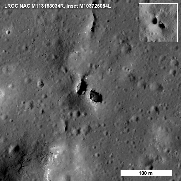
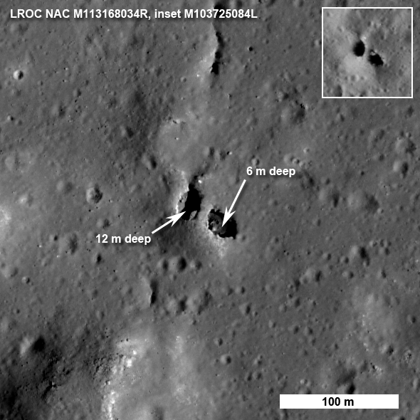
By November 18, 2009, LRO was several weeks into the year-long Nominal mission, circling the Moon at an average altitude of 54 kilometers. This "Shadow under a Walking Bridge" and Featured Image (Inset) view was released with its announced discovery, September 7, 2010. Below that is shown a greatly reduced "full-width" of the Right Frame image from the LROC NAC observation, to allow for context. LROC NAC M113168034R, from 60.49 km, LRO orbit 1811 (Res. 0.625 m, phase angle = 46.36°) [NASA/GSFC/Arizona State University].

Wednesday, September 8, 2010

Moon's Eastern Hemisphere from LROC WAC

Updated September 16, 2010 2000 UT

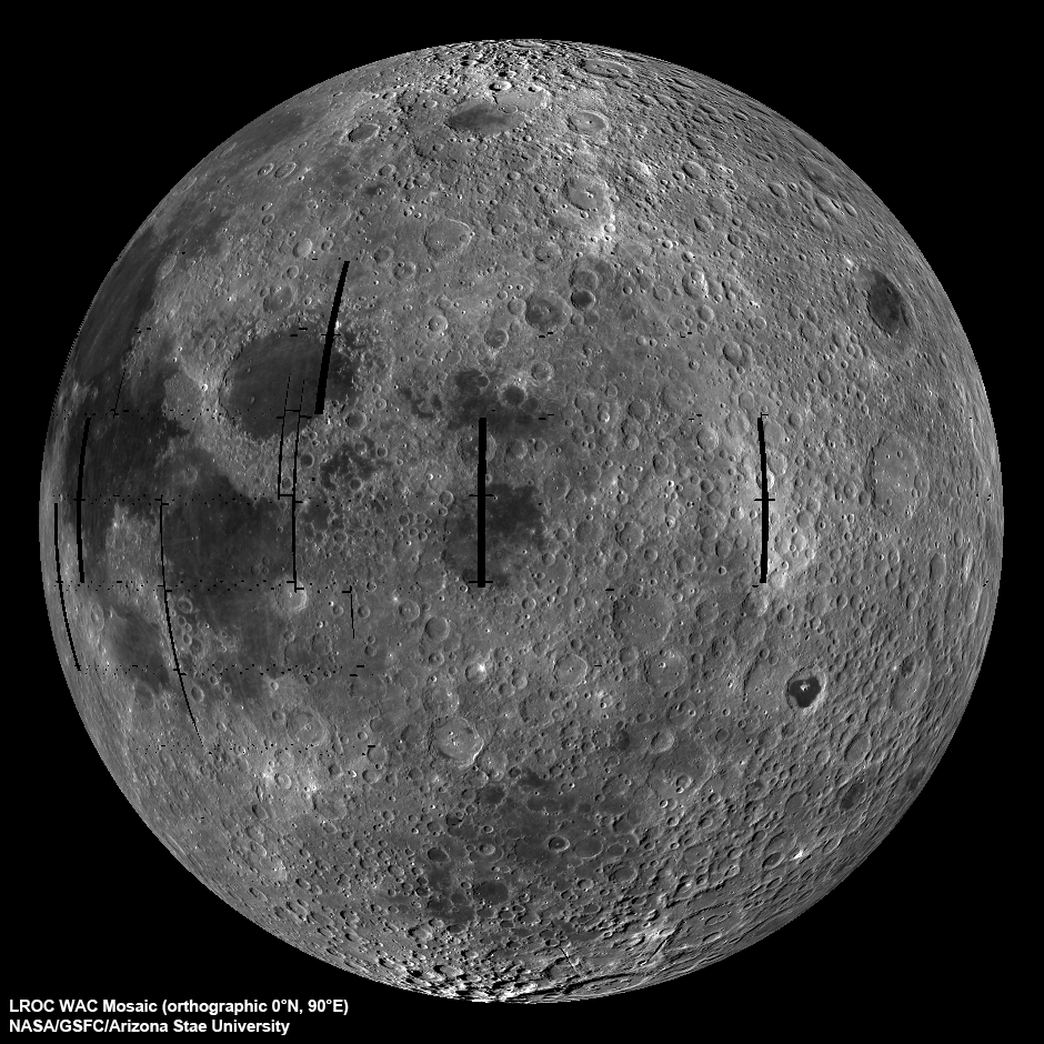
LROC Wide Angle Camera (WAC) view of the Moon seen from 90° east longitude. Half the nearside is visible to the left, and half the farside to the right [NASA/GSFC/Arizona State University].

Mark Robinson
Principal Investigator
Lunar Reconnaissance Orbiter Camera
Arizona State University


The LROC WAC is a real workhouse and gets little attention, at least so far. Since the WAC is a wide angle camera, it maps nearly the whole Moon over a course of about 4 weeks and the lighting and viewing geometries are complicated. In the first case, the Sun angle at the equator changes about 28°. This change in lighting over a mosaic cycle results in a very different surface brightness where the end of the mosaic meets the beginning. The viewing angle of the WAC changes from straight down at the center to 45° at the edge since the camera's field-of-view is 90°. The extreme angle at the edges results in geometric distortion and an apparent change in brightness of the surface. Both effects need to be removed to make mosaics and the LROC team has been working on corrections since this Spring. The global mosaic from which this view was produced contains over 3700 WAC images, which translates into a lot of processing! Note that the black "holes" (gores) are the result of LRO slewing off nadir to acquire NAC stereo images. Over the course of the mission these gores will be imaged and the mosaic completed.


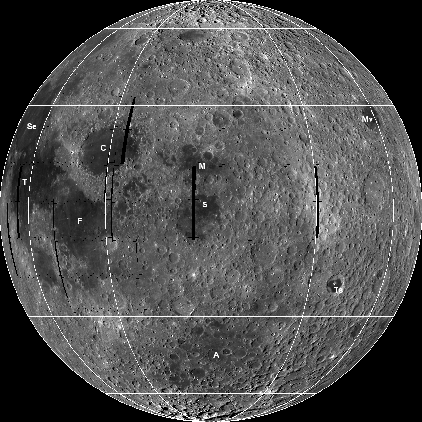
Annotated version of the WAC eastern hemisphere orthographic mosaic: Se=Mare Serenitatis,T=Mare Tranquillitatis, F=Mare Frigoris, C=Mare Crisium, M=Mare Marginis, S=Mare Smythii, A=Mare Australe, Ts=Mare Tsiolkovskiy, Mv=Mare Moscoviense. Lat/lon grid in increments of 30° with the center coordinate at 0°N and 90°E [NASA/GSFC/Arizona State University].

Great progress has been made and the preliminary products are now starting to flow. Keep checking back as more WAC products are released in the coming weeks.

Explore the 400 m/pixel WAC view of the eastern hemisphere of the Moon!

Visit the LROC Wide Angle Camera mosaic of South Pole Aitken basin and another of the Orientale basin.

Tuesday, September 7, 2010

Natural Bridge on the Moon

Updated September 16, 2010 2006 UT

Another amazing bit of lunar geology revealed by LROC, northwest of Narrow Angle Camera (NAC) observation M113168034R (Near 6.41°N, 119.74°E, within an impact melt "pond," inundating the depression King Y, immediately northwest of far side landmark King crater. (North is up; LRO orbit 1811, November 18, 2009; alt. 60.49, res. 0.625 m, phase angle = 46.36°) [NASA/GSFC/Arizona State University].

Mark Robinson
Principal Investigator
Lunar Reconnaissance Orbiter Camera
Arizona State University

Just when you think you have seen everything, LROC reveals a natural bridge on the Moon!

Who would have thought? Natural bridges on Earth are typically the result of wind and water erosion - not a likely scenario on the Moon. So how did this natural bridge form? The most likely answer is a dual collapse into a lava tube. From the Apollo era, SELENE, and LROC images, we know that lava tubes did form in the Moon's ancient past. SELENE and LROC images have raised the tantalizing prospects that lava tubes remain intact to this day. However this bridge did not form in mare (basalt), but rather in (a splash of) impact melt from King crater! More astonishingly, the same NAC image revealed two natural bridges - not just one!


The bridge is approximately 7 meters wide on top and perhaps 9 meters on the bottom side, a 20 meter walk to cross from one side to the other (see full-size view of above, HERE [NASA/GSFC/Arizona State University].

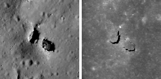
How do we know for sure that this feature is truly a bridge? Look closely at the west pit (left side) and you can see a little crescent of light on its floor. That patch of light came from the east, under the bridge. In another lower resolution image (see inset), you can see light passed under the bridge from the west. So there must be a passage. How did this oddity form? The impact melt deposit on the north rim of King crater is over 15 km across and was emplaced in a matter of minutes as the crater grew to its final configuration.


King Y: A large (17 km east to west), smooth impact melt "pond" on the northwest rim of King crater (5°N, 120.5°E - 72 kilometers in diameter). LROC WAC mosaic [NASA/GSFC/Arizona State University].

The impact melt that was thrown out of the crater pooled on the newly deposited ejecta and must be many tens of meters thick, allowing its interior to stay molten for a long time. As the local terrain readjusted after the shock of the impact, the substrate of this massive pool of melt was jostled to some degree. Local pressures built up and the melt moved around under a deforming crust. You can see that the south end of the bridge extends from a small local rise, shaped something like a blister. Perhaps some melt was locally pushed up forming the rise, then the magma found a path to flow away, leaving a void which the crusted roof partially collapsed? Right now we do not know for certain the details of how the bridge formed, however, the LROC team is processing stereo images into topographic maps to aid scientists in determining exactly what took place on this fascinating melt sheet. There are actually six NAC images in which you can find the bridge under varying lighting (M103725084L, M103732241L, M106088433L, M113168034R, M123785162L,* M123791947L*). Why so many images?

The melt sheet north of King crater is one of fifty Constellation Regions of Interest - high priority for LROC coverage. As the pair of images below vividly illustrate, having a set of images of the same area under varying lighting allows scientists to more confidently interpret the local geology and thus better prepare for future exploration.


Left shows the bridge when the Sun is 42° above the horizon and the right is the same area when the Sun is 80° above the horizon (near noon). M113168034R on the left, M123791947L* on the right, both are 128 meters across, north is up - full-sized inset, HERE [NASA/GSFC/Arizona State University].

Explore the entire LROC NAC image and investigate the variety of geologic features in the King crater melt sheet. Can you find the second natural bridge in the full NAC frame (hint - it's fairly close to the one shown above and about half its size)?

Learn more about the Constellation Regions of Interest:

Tier1 Regions
Tier2 Regions

*LROC Narrow Angle Camera observation M123785162L & M123791947L are not yet available through the Planetary Data System.

M113168034RE sampled at full resolution and pushed to 200%

Discovering the King Y Natural Bridge


Credited as the first view of the natural bridge discovered in high-resolution surveys of the King Crater Constellation Region of interest (ROI). This 400 x 400 pixel segment, cropped from a 5064 x 52224 pixel Narrow Angle Camera (NAC) strip was swept up early in the Lunar Reconnaissance Orbiter (LRO) mission, August 1, 2009. The vehicle was slewed -6.09° to image the King ROI target, 118.57 kilometers over the Moon. The field of view is approximately 480 meters. LROC NAC observation M103725084L, orbit 451 (Res. 1.22 m, Sun-Moon-LRO phase angle 68.74°) [NASA/GSFC/Arizona State University].


The subsequent orbit (LRO orbit 452) over King brought cameras nearer to being directly over the natural bridge, and this slightly better view was captured, again on August 1, 2009, from 118.72 kilometers. The field of view is approximately 480 meters. LROC NAC observation M103732241L; Res. 1.2 meters, phase angle 53.57° [NASA/GSFC/Arizona State University].


The next opportunity to image the King ROI took place a lunar month later, August 28, 2009, still in the LRO Commissioning phase of its mission. The Natural Bridge was imaged in afternoon sunshine from 127.88 kilometers, and the 400 pixel field of view was approximately 517 meters. LROC NAC observation M106088433LE, LRO orbit 781, res. 1.29 m, phase angle 36.92° [NASA/GSFC/Arizona State University].


By November 18, 2009, LRO was several weeks into the year-long Nominal mission, circling the Moon at an average altitude of 54 kilometers. This "Shadow under a Walking Bridge" and Featured Image (Inset) view was released with its announced discovery, September 7, 2010. Below that is shown a greatly reduced "full-width" of the Right Frame image from the LROC NAC observation, to allow for context. LROC NAC M113168034R, from 60.49 km, LRO orbit 1811 (Res. 0.625 m, phase angle = 46.36°) [NASA/GSFC/Arizona State University].

Monday, September 6, 2010

Lunar superlatives from LROC WAC


The 'Rooftop of the Moon' appears to be on the wide, flat northwest rim of 43 km-wide Engel'gard, the largest crater in this monochrome sample from the LROC Wide Angle Camera. The actual spot (5.44°N, 201.36°E) is not immediately distinct, as are Everest or Denali, for example. A future traveler standing there, 10.75 km above the global mean elevation might notice little beyond a close horizon. A brief 'bunny hop' may be necessary to get to an overlook, to see breathtaking views of astounding depths and distances. LROC WAC observation M103209735ME, field of view roughly 100 km; LRO orbit 379, July 26, 2009; alt. 112.88 km, res. 178.3 meters, phase angle 66.22° [NASA/GSFC/Arizona State University].


Barely 2400 km from the Moon's highest point is it's lowest point, invisible above, inside the shadows of the 12 km crater at middle-left, within the wide interior of 143 km-wide Antoniadi, not far from the center of 4 billion year old South Pole-Aitken basin. From Kaguya the smaller crater's interior (70.43°S, 187.42°E) was measured to a depth of 9.06 km below global mean (19.85 kilometers below the high point at Engle'hardt and 2 km more than the range gauged as recently as 2005). This image was processed using LROC WAC Previewer (v.1.2) from LROC WAC observation M103254154ME; field of view approximately 150 km; LRO orbit 385, July 26, 2009; alt. 42.68 km, res. 66.03 meters, phase angle 82.5° [NASA/GSFC/Arizona State University].


The bright, highest of the Moon's highlands as seen from Kaguya as the orbiter sailed under a late morning Sun. [JAXA/NHK/SELENE].


Also from Kaguya, the Moon's lowest place (70.43°S, 187.42°E) is briefly seen at the bottom of the bowl-shaped crater in wider Antoniadi. All the scenery in this late mission Terrain Camera image averages a few kilometers lower in lunar elevation than anything we can see of the Moon's near side from Earth. [JAXA/SELENE].