Showing posts with label JAXA. Show all posts

Sunday, July 7, 2013

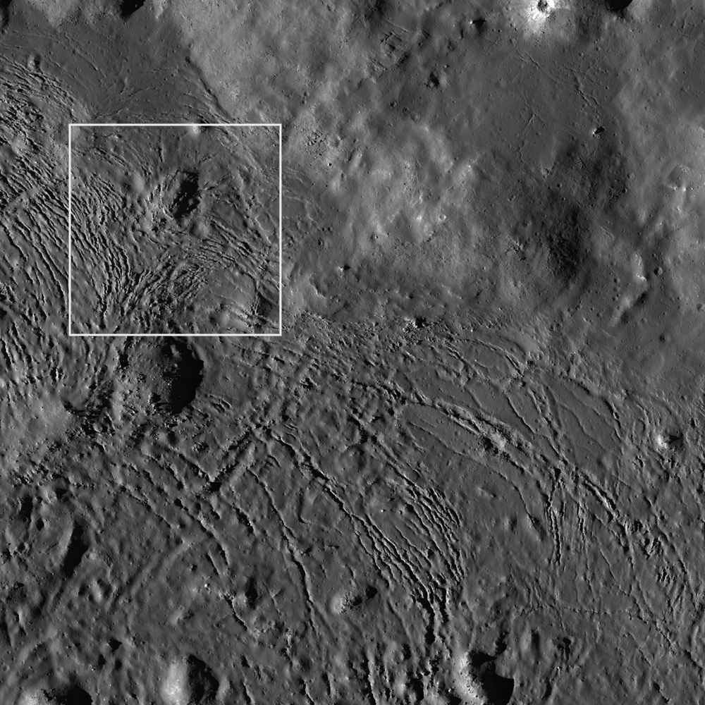
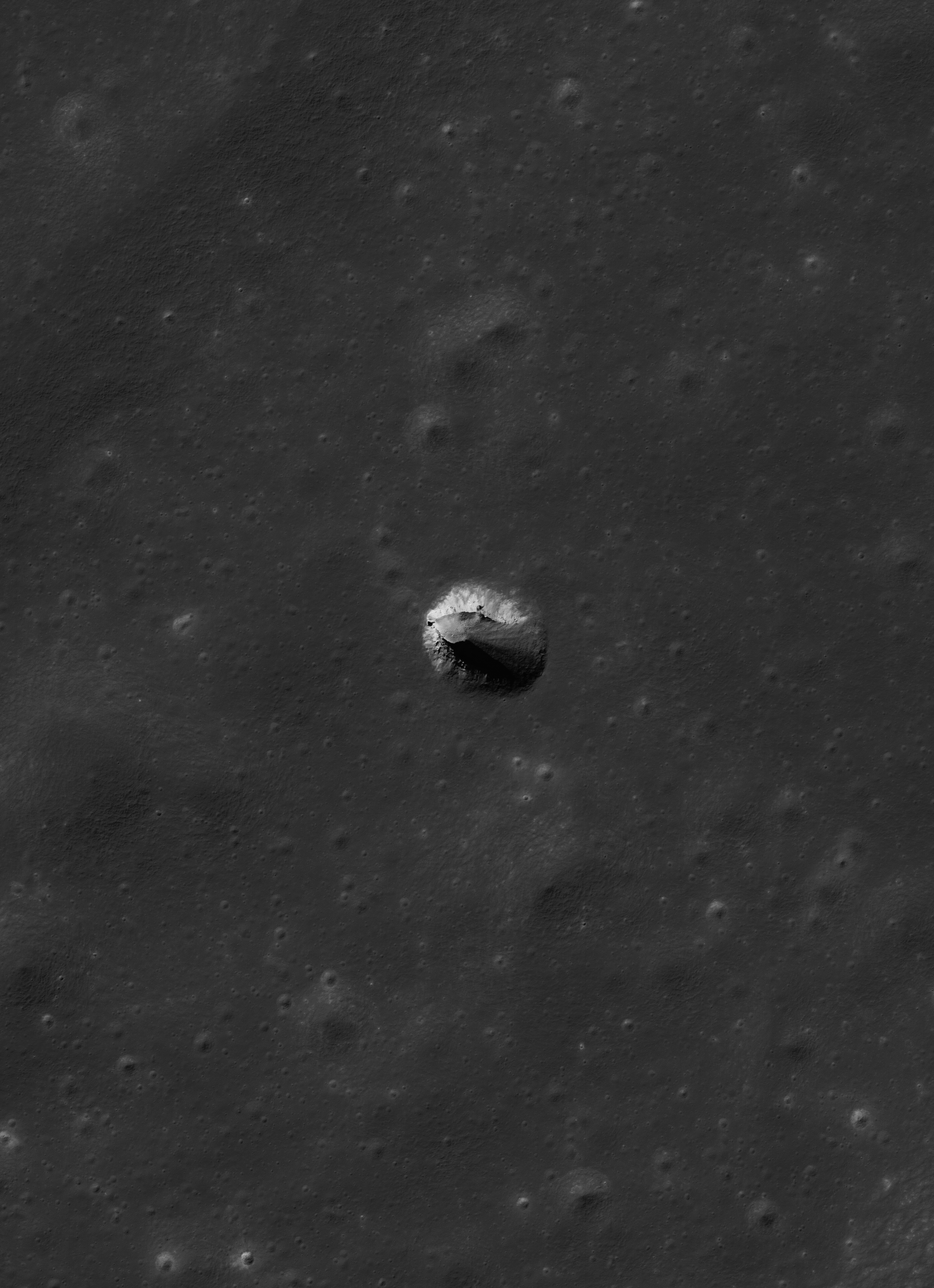
Twin mare pit craters in the Lake of Death

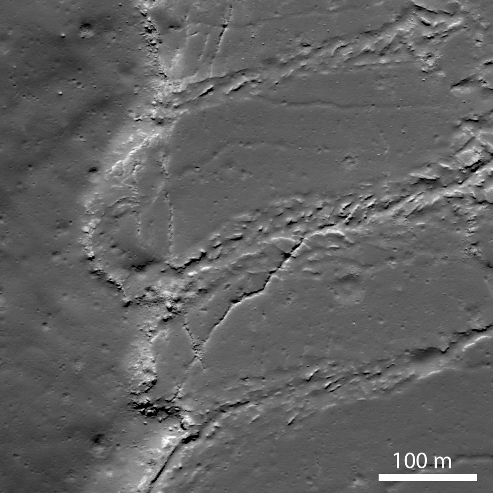
Layers of terrain, the foundation under the heavily gardened upper surface of Lacus Mortis, "the Lake of Death," hints this feature, averaging 228 meters across, was, or is, a "pit crater," closely related to similar structures (discovered in the 21st century) near the Marius Hills, in Mare Tranquillitatis, Mare Ingenii and elsewhere. Though the east wall collapsed there may yet be an opening below a ledge. LROC Narrow Angle Camera (NAC) observation M126759036L, orbit 3814, April 24, 2010; 49.4° angle of incidence, resolution 0.5 meters from 45.56 km [NASA/GSFC/Arizona State University].
Joel Raupe
Lunar Pioneer

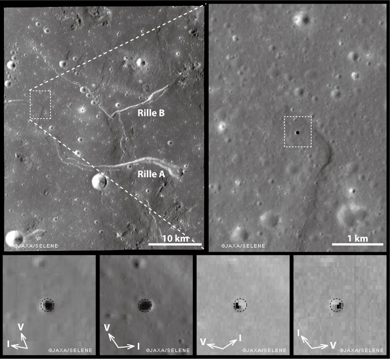
It was something of a sensation just a few years ago when Kaguya (SELENE-1) images unveiled a "pit crater," an honest to goodness opening into a sublunarean world.

Ant this new feature was found right in the middle of the long-observed and studied channel of the unofficially named "Sinuous Rille A," in the Marius Hills of Oceanus Procellarum. What a difference, many thought, high resolution photography would make of our knowledge of the lunar surface.

And they were not disappointed. Most of what we now know of the lunar surface is entirely a product of the 21st century, largely a pay off from "precursor" missions vital to the success of a now-scrubbed program ahead of a return to the surface of "extended human activity" later this decade.

Junichi Haruyama and his colleagues reported their findings in Geophysical Research Letters in 2009, having captured the Marius Hills Pit at resolutions as high as 6 meters per pixel using the Kaguya Terrain Camera and Multiband Imager, as discussed by LROC principle investigator Marc Robinson, March 1, 2010.
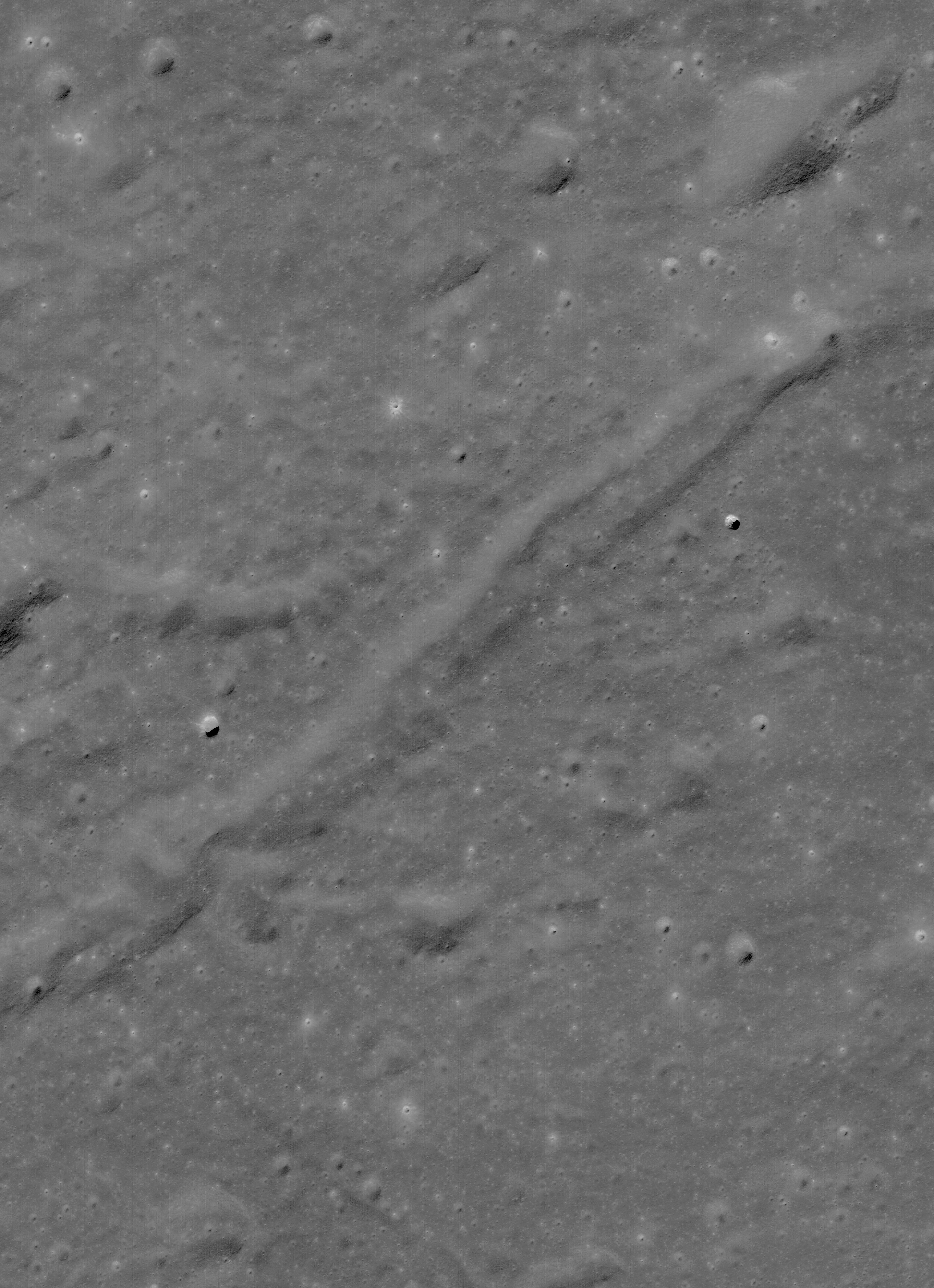
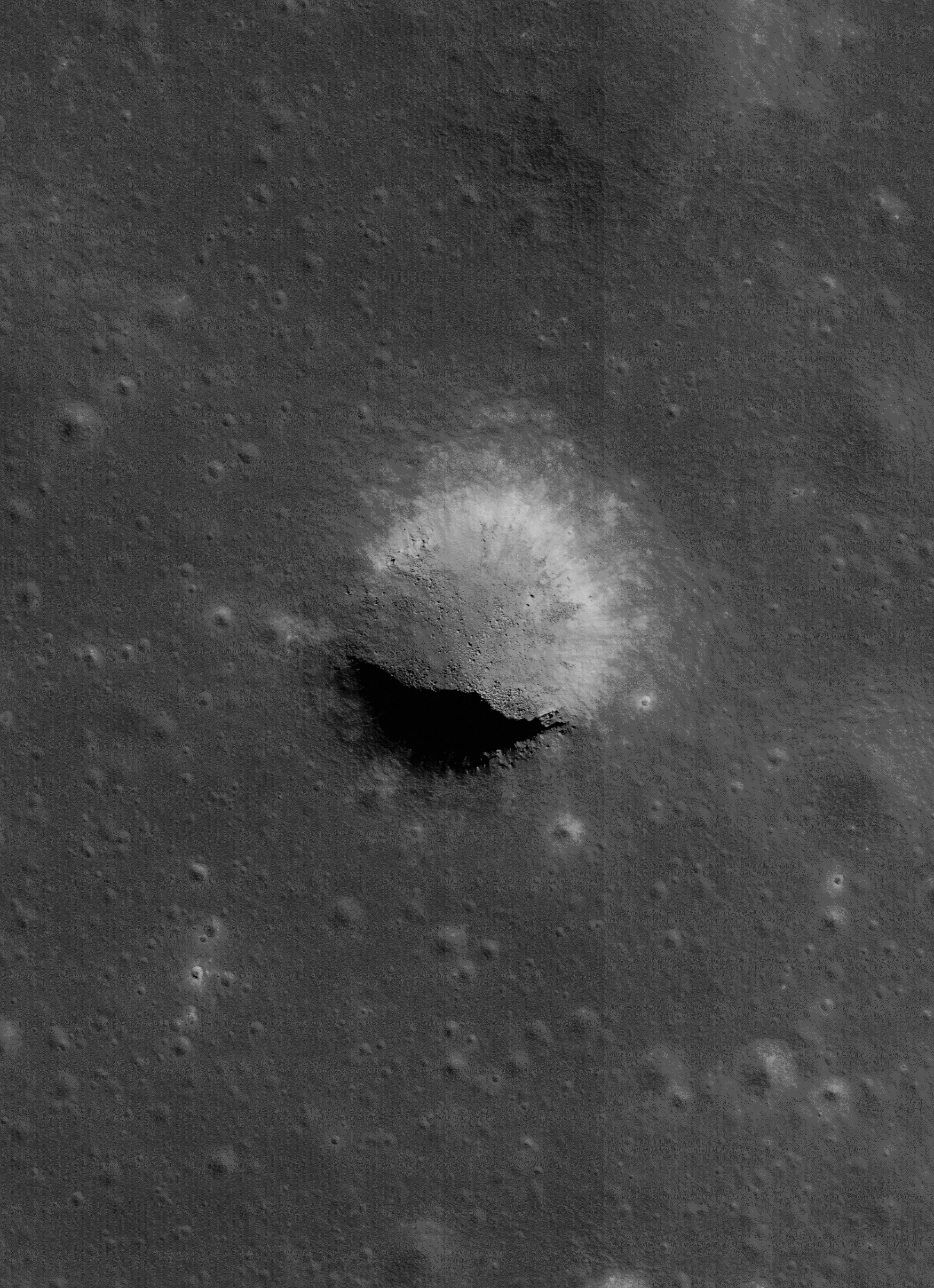
The same partially collapsed, or filled-in, pit crater in the Rimae Burg region of Lacus Mortis (44.96°N, 25.62°E), from an oblique LROC NAC mosiac M1105701957LR, with spacecraft slewed -41.94° off nadir, orbit 15246, October 24, 2012; 59.78° incidence angle, 2 meters resolution from 155.54 km over 44.92°N, 25.52°E. Explore a full-resolution version HERE [NASA/GSFC/Arizona State University].
Not many months after the controlled impact of Kaguya the Lunar Reconnaissance Orbiter began its long and productive tour in lunar orbit.

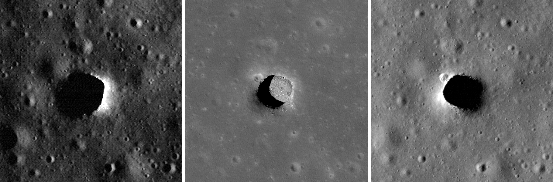
Early in that still-ongoing mission the LROC team at Arizona State University released their own high-resolution NAC images of the Marius Hills Pit, and under a variety of lighting angles, while announcing the discovery of two additional, even larger and more distinctive "pits" in the western interior of Mare Ingenii and the well-preserved example near Sinas J, not far from the vent structures at the west terminus of Rupes Cauchy, in the middle of Mare Tranquillitatis.

These new images left little doubt that significant underground areas existed on the Moon, though how far these sublunarean areas stretched beyond their exposed "skylights," the true scope of the Moon's near-surface underground world, must remain a mystery for some time to come.

M122041942LR-NSJ-0503-58b-1986x2739
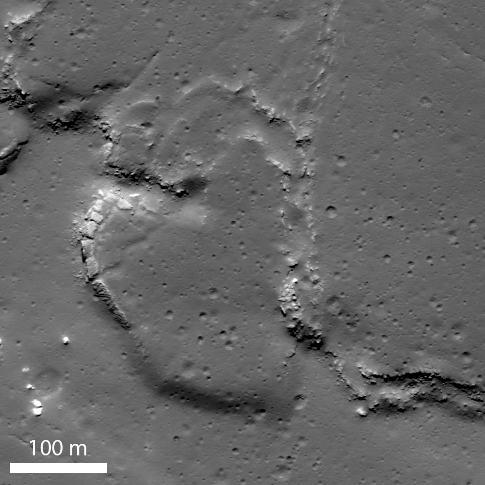
For a while mare pit craters seemed to be solitary creatures, all alone where they have now been extensively photographed. But the partially filled examples in Lacus Mortis might be near "twins." The 250 meter-wide pit crater above is only 9.7 km southwest of its neighbor (in the first image above - a 13 km walk) from 44.80857°N, 25.21157°E. The view above is from a kilometer-wide field of view from LROC NAC mosaic M122041942LR, orbit 3119, March 1, 2010; 0.5 meters resolution from 46.11 km. (Download the very large original mosaic HERE) [NASA/GSFC/Arizona State University].

These features seemed to be rare and solitary. Rough treatment of the lunar surface, aeons of steady and sometimes heavy bombardment seemed to leave very few of these openings intact. Perhaps the same may be true of extended "lava tubes," and other tantalizing, hoped-for discoveries.

Planetary scientists and geologists have studied the interior walls of these structures. The LROC team has released a high volume of imagery of the Tranquillitatis pit crater, for example, and attempts have been made to map the history of lava inundations recorded in the exposed layers.

Following discovery of three, widely dispersed pit craters at Marius, Tranquillitatis and Ingenii, at least two more smaller and much less distinct examples have turned up Mare Fecunditatis and Mare Smythii.

The unique Natural Bridge feature of King Y is a nearly unique example of the much more widespread family of collapse and channel remnants common to impact melts, both inside and outside relatively "recent" impacts, like the northeast quadrant of the interior of Copernicus, for example, and deep inside Messier A. To distinguish these from the Marius-Tranquillitatis-Ingenii family of openings, the latter are now referred to as mare pit craters.

Far from being as widespread as melt channels and collapse pit, the Mare Pit Craters seemed to be solitary, perhaps one to a plain, if any at all. As seems common to all deep space discoveries, however, of course there had to be an exception.

M1105701957R-NSJ-0407-58b-4747x6548
"Twin" Mare Pit Craters, roughly 10 km apart (as the LM ascent stage flies) on opposite sides of the primary channel in the Rimae Burg region, west-central Lacus Mortis. This field of view is 15.72 km across, from LROC MAC mosaic M1105701957LR [NASA/GSFC/Arizona State University].
In the west central interior of the rugged Lacus Mortis plain are two near-quarter kilometer-wide pits, though both are either partially or completely filled in. They are intriguingly situated on opposite sides of a main channel north of its junction with a distinctive faulting in the Rimae Burg vicinity, northeast of the volcanoes highlighted in an LROC Featured Image (Volcanoes in the Lake of Death), August 11, 2010.

Lacus Mortis, from the LROC web-based PDS search tool, showing the prior image field of view outlined by a white rectangle. Note the concurrence with a junction zone of the fault and channel constituents of Rimae Burg [NASA/GSFC/Arizona State University].
The interior walls of the northeastern twin, shown in the first two images above, retains the kind of layering seen in the Tranquillitatis and Ingenii pits, evidence of periodic lava flooding in the remote past. This bedrock under Lacus Mortis makes for a tough roof, but over what? Have any of these mare pit craters yet been found over the deeper basins?

The east-southeast wall of the northeast pit seems to have filled in, like a forgotten entrance to a pharaoh's tomb, though the south interior stays in hard shadow at this latitude. But the north wall offers up a shadow ring where the sun's angle should be well placed for illumination, hinting at an unseen and deeper interior perhaps.

The perspective from Earth, the area of interest marked by a bright asterisk in west central Lacus Mortis, an eyebrow for the "Man in the Moon" (yellow rectangle in inset). From a First Quarter Moon montage captured April 21, 2010. Photo by Yuri Goryachko, Mikhail Abgarian, Konstantin Mororzov - ASTRONOMINSK, Minsk, Belarus.
Sadly, the southeastern twin, though apparently the "real deal," appears very degraded. Exterior regolith, heavily pounded by the steady bombardment of the micrometeorites gardening the upper three centimeters of the lunar surface every two million years, has spilled over filled the interior. Its south wall, in high latitude shadow, stays invisible in shadow, but with little visible component leading to an indication of any difference with the rest of its fine-grained interior fill.

Did these two examples of mare pit craters, perhaps the only such "twins" on the Moon, degrade more quickly because of a greater age than their more noted cousins at Tranquillitatis or Ingenii? Did the arrival of the impact that formed Burg cave them in? Is this area more prone to Moonquakes?

Related Posts:
Pit Crater in Fecunditatis (May 23, 2013)
Copernicus Collapse Pit (March 5, 2013)
Layering in Messier A (July 22, 2011)
Sublunarean Void (February 8, 2011)
New views of lunar pits (September 14, 2010)
Natural Bridge on the Moon (September 7, 2010)
Depths of Mare Ingenii (June 16, 2010)
How common are mare pit craters? (July 15, 2010)
Paul Spudis: Caves on the Moon (October 28, 2009)

Tuesday, July 17, 2012

JAXA announces SELENE-2 now slated for 2017

Japan's SELENE-2 follow-up to the versatile Kaguya (2007-2009) orbiter has remained essentially the same in design since originally proposed. Participation by Japan's experienced astronaut corp in any future manned mission to the Moon carried out by the United States government may now be some distance beyond 2017 [JAXA].
A representative of Japan's space agency JAXA announced Sunday in India that planning is definitely underway to launch the long-anticipated sequel mission to that nation's first lunar orbiter, "Kaguya" (SELENE-1) in 2017. Because budgeting for the mission has been "delayed" twice through Japan's own sovereign debt difficulties news that JAXA has not abandoned the mission design is encouraging.

Tatsuaki Okada, representing JAXA, made reiterated Japan's determination to carry out the SELENE-2 mission at the 39th Scientific Assembly of the Committee on Space Research (Cospar) now underway at Mysore, Karnataka State, in India. According to a report posted by Srinivas Laxman of AsianScientist "nearly 3,000 space scientists from 74 countries are participating in the meeting."

Originally anticipated for a launch in 2012, 2015, and then lost on the budgetary cutting room floor, Okada said Japan's plans for SELENE-2 still included an orbiter, lander and rover. 

“It is for developing and for the demonstration of key technologies for future human exploration," Okada said. "It is a multipurpose mission which is a precursor for human exploration,” he told a Cospar session on lunar sciences. Okada later told Asian Scientist Magazine a future manned lunar mission "will be in collaboration with NASA."

“While the rocket and the lunar lander will be from NASA," Okada said, according to Laxman, "the astronaut will be from Japan. There will be science exploration and moon utilization by the Japanese astronaut.”

Okada also, according to Laxman, "did not rule out SELENE-2 being delayed once again, because of budgetary constraints."

The SELENE-2 design calls an orbiter weighing 700 kg, a lander at 1,000 kg and a small 100 kg rover, though the lander, in line with earlier reports, may have additional capacity for an additional 100 kg payload.

Okada said eleven landing sites were under consideration, including the Fra Mauro region explored by Alan Shepard and Edgar Mitchell of Apollo 14 in 1971. The SELENE-2 lander is not being designed for long-duration stay on the lunar surface, requiring survival through a lunar night. The mission will begin with arrival at local sunrise and come to and end with the loss of solar power at sunset, 14 days later.

Saturday, July 14, 2012

Kaguya's digital elevation model as fine wall art

"Mare Orientale," is both title and subject of this 96.5 centimeter-wide, three-panel work carved in Sapele, a 'flesh-colored African wood.' Sirsalis is easy enough to pick out, at lower right, along with other highlights of west central Procellarum, and westward along the north east quadrant of Orientale. The work is said to have 'has an opalescent grain,' the highlights of which 'shimmer as the viewer passes by,' writes Craig Dorety, the artist who currently has this and similar works based on the Kaguya (SELENE-1) digital elevation model on exhibition until August 17 [Photographed by Susan Fowler].
Xeni Jardin
San Francisco-based artist Craig Dorety has a series of carvings that "represent segments of the moon's surface as found in the topograhical data from JAXA's Kayuga mission."

"Painstaking attention is paid to the relationship of crater groups in the composition of each carving," Craig explains. "Areas of special interest have a natural balance of crater to sea; rough to gentle in texture."

Read the full article, HERE.

Thursday, June 21, 2012

Shackleton harbors ice after all

Spoke too soon! When JAXA released this Kaguya Terrain Camera image, showing the deep interior of Shackleton crater for the first time in 2008, scientists claimed it disappointingly showed no indication of ice, though no one yet can say how a slurry of lunar volatiles might appear. Now, however, researchers analyzing laser altimetry returned by the LOLA instrument on-board the Lunar Reconnaissance Orbiter (LRO) cite strong evidence of ice content in the permanently shadowed interior.  The Moon's south pole is serendipitously situated on Shackleton's rim, directly under all of LRO's nearly twenty thousand polar orbits since 2009, affording extraordinary study [JAXA/SELENE]..
Jennifer Chu

If humans are ever to inhabit the moon, the lunar poles may well be the location of choice: Because of the small tilt of the lunar spin axis, the poles contain regions of near-permanent sunlight, needed for power, and regions of near-permanent darkness containing ice — both of which would be essential resources for any lunar colony.

The area around the moon’s Shackleton crater could be a prime site. Scientists have long thought that the crater — whose interior is a permanently sunless abyss — may contain reservoirs of frozen water. But inconsistent observations over the decades have cast doubt on whether ice might indeed exist in the shadowy depths of the crater, which sits at the moon’s south pole.

Now scientists from MIT, Brown University, NASA’s Goddard Space Flight Center and other institutions have mapped Shackleton crater with unprecedented detail, finding possible evidence for small amounts of ice on the crater’s floor. Using (the LOLA) laser altimeter on the Lunar Reconnaissance Orbiter (LRO) spacecraft, the team essentially illuminated the crater’s interior with laser light, measuring its albedo, or natural reflectance. The scientists found that the crater’s floor is in fact brighter than that of other nearby craters — an observation consistent with the presence of ice, which the team calculates may make up 22 percent of the material within a micron-thick layer on the crater’s floor.
 

The group published its findings today in the journal Nature.

In addition to the possible evidence of ice, the group’s map of Shackleton reveals a “remarkably preserved” crater that has remained relatively unscathed since its formation more than three billion years ago. The crater’s floor is itself pocked with several smaller craters, which may have formed as part of the collision that created Shackleton.

The crater, named after the Antarctic explorer Ernest Shackleton, is more than 12 miles wide and two miles deep — about as deep as Earth’s oceans. Maria Zuber, the team’s lead investigator and the E.A. Griswold Professor of Geophysics in MIT’s Department of Earth, Atmospheric and Planetary Sciences, describes the crater’s interior as “extremely rugged … It would not be easy to crawl around in there.”

Mapping the dark. Slipping past the Moon's south pole on the brightly lit rim of Shackleton crater, the dark of the permanently shadowed interior of the crater quickly overtakes a very steep crater wall, like the terrestrial oceans. LRO has skipped through thousands of polar orbits eventually carrying the vehicle over every area on the Moon's surface and over Shackleton, high at the top of everyone's list of priority targets, during every orbit,   LROC Narrow Angle Camera (NAC) M142464150L, LRO orbit 6128, October 23, 2010, 89.21° angle of incidence, 0.87 meters resolution from 41.91 kilometers [NASA/GSFC/Arizona State University].
The group was able to map the crater’s elevations and brightness in extreme detail, thanks in part to the LRO’s path: The spacecraft orbits the moon from pole to pole as the moon rotates underneath. With each orbit, the LRO’s laser altimeter maps a different slice of the moon, with each slice containing measurements of both poles. The upshot is that any terrain at the poles — Shackleton crater in particular — is densely recorded. Zuber and her colleagues took advantage of the spacecraft’s orbit to obtain more than 5 million measurements of the polar crater from more than 5,000 orbital tracks.

“We decided we would study the living daylights out of this crater,” Zuber says. “From the incredible density of observations we were able to make an extremely detailed topographic map.”

The team used the (LOLA) to map the crater’s elevations based on the time it took for laser light to bounce back from the moon’s surface: The longer it took, the lower the terrain’s elevation. Through these measurements, the group mapped the crater’s floor and the slope of its walls.

A quaking theory.The researchers also used the laser altimeter to measure the crater’s brightness, sending out pulses of infrared light at a specific wavelength. The crater’s surface absorbed some light based on its own natural albedo, reflecting the rest back to the spacecraft. The researchers calculated the difference, and mapped the relative brightness throughout the crater’s floor and walls.

While the crater’s floor was relatively bright, Zuber and her colleagues observed that its walls were even brighter. The finding was at first puzzling: Scientists had thought that if ice were anywhere in a crater, it would be on the floor, where very little sunlight penetrates. The upper walls of Shackleton crater, in comparison, are occasionally illuminated, which could evaporate any ice that accumulates.

How to explain the bright walls? The team studied the measurements, and came up with a theory: Every once in a while, the moon experiences seismic shaking brought on by collisions, or gravitational tides from Earth. Such “moonquakes” may have caused Shackleton’s walls to slough off older, darker soil, revealing newer, brighter soil underneath.
Until very recently luna incongnita, the permanently shadowed 10.3 km-wide interior of Shackleton, shouldering the Moon's south pole (blue arrow), today seems much like hundreds of other lunar craters of similar age and dimension. Its ink-black interior has steadily been brightly unveiled in a steady build-up of laser data points collected over the course of three years in polar orbit by the LOLA instrument on LRO. As it is on Earth, however, in Real Estate, "location is everything" [NASA/GSFC/LOLA].

Zuber says there may be multiple explanations for the observed brightness throughout the crater: For example, newer material may be exposed along its walls, while ice may be mixed in with its floor. Her team’s ultra-high-resolution map, she says, provides strong evidence for both.

Ben Bussey, staff scientist at Johns Hopkins University’s Applied Physics Laboratory, says the group’s evidence for ice in Shackleton crater may help determine the course for future lunar missions.

“Ice in the polar regions has been sort of an enigmatic thing for some time … I think this is another piece of evidence for the possibility of ice,” Bussey says. “To truly answer the question, we’ll have to send a lunar lander, and these results will help us select where to send a lander.”

Zuber adds that the group’s topographic map will help researchers understand crater formation and study other uncharted areas of the moon.

“I will never get over the thrill when I see a new terrain for the first time,” Zuber says. “It’s that sort of motivation that causes people to explore to begin with. Of course, we’re not risking our lives like the early explorers did, but there is a great personal investment in all of this for a lot of people.”

The research was supported by the Lunar Reconnaissance Orbiter Mission under the auspices of NASA’s Exploration Systems Mission Directorate and Science Mission Directorate.

Japan's scientists may have leaped to conclusions when they over-confidently announced there was no ice inside Shackleton (upper left), after releasing the first image of the crater's interior a few years ago, but their iconic high-definition image of an orbital Earthrise from November 2007 still takes the breath away [JAXA/NHK/SELENE].

Wednesday, June 20, 2012

LROC: "River of Rock"

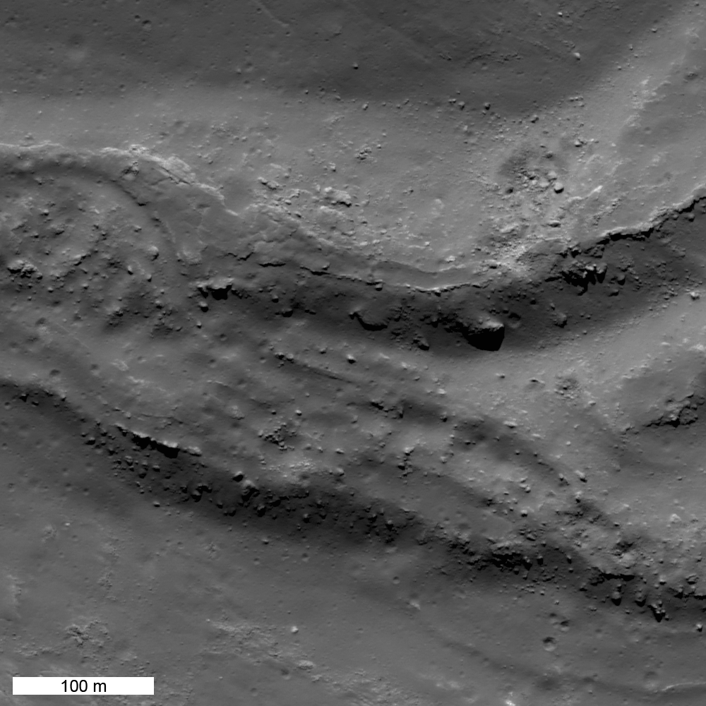
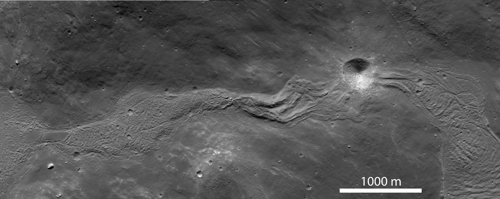
A small section of an enormous, now frozen, river of impact melt that flowed down the southeastern flank of Tycho crater some 108 million years ago. LROC Narrow Angle Camera (NAC) observation M185940195RE, LRO orbit 12480, March 9, 2012; angle of incidence 46.55° at 0.64 meters resolution from 61.72 kilometers. View the full-size 1000 x 1000px LROC Featured Image HERE [NASA/GSFC/Arizona State University].
Jeffrey Plescia
LROC News System

Impact melt is one of most spectacular products of impact cratering events. A comet or asteroid impacts the Moon at 10-60 km/sec, and releases so much energy that it melts a significant amount of the target rock. The larger the projectile, the bigger the crater, and the more melt that is produced. While much of the Tycho impact melt pooled on crater floor, some of it was thrown out of the crater onto the rim. A large mass of impact melt landed on the southeastern rim and flowed down the rim filling low areas and then spilling over and continuing downhill. Between pools, the melt formed narrow flows whose width was controlled by the topography.

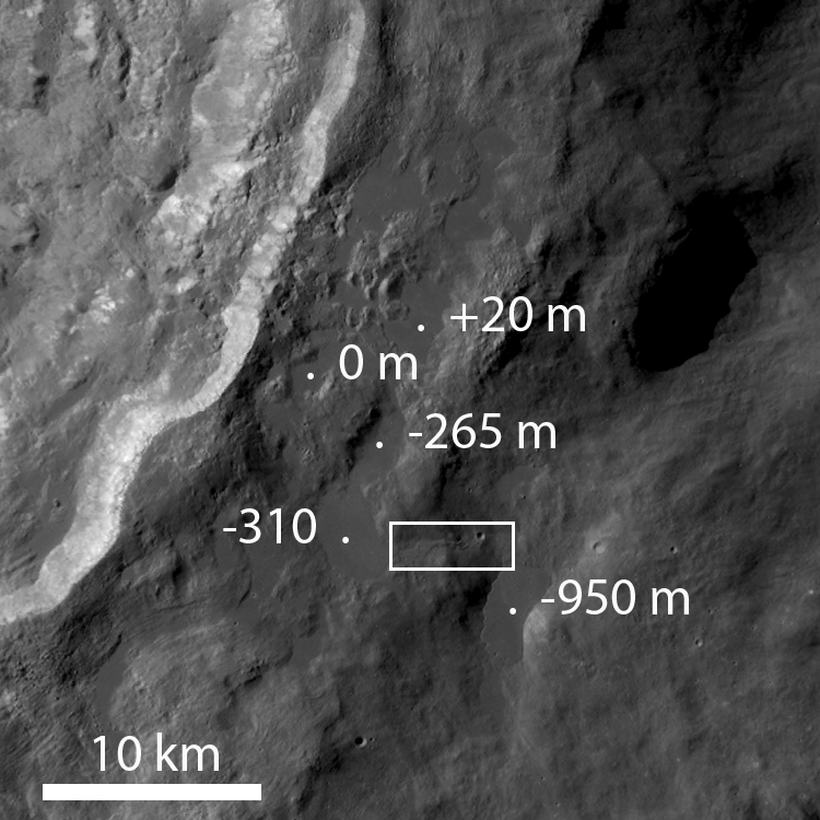
The context image (sub-sampled NAC mosaic) below shows a wider view of the impact melt deposit extending down slope from a high pool (on the left side of the image) at an elevation of about -310 m to a lower pool on the (on the right side of the image) that lies more than 600 m downslope (elevation -950 m). The flow is about 5000 m long; its width ranges from 300 to 700 m and is controlled by the topography of the surrounding hills. The texture of the flow surface and the formation of channels on its eastern end (above and below the crater) is a function of the slope of the underlying surface, and the changes in viscosity of the melt as it cools.

This contextual montage of the corresponding left and right frames of LROC NAC observation M185940195 allows this view of spectacular river of impact melt, now frozen, that briefly flowed down the southeastern flank of Tycho crater. View the spectacular full-size (2000 x 800px) context view HERE [NASA/GSFC/Arizona State University].
Contextual LROC Wide Angle Camera (WAC) image of the various pools and their elevations. Over distances of 10-20 km, the melt flowed down almost a kilometer in elevation. The white box roughly outlines the field of view shown in detail immediately above. LROC WAC observation M177698611C (604nm), orbit 11323, December 5, 2011, illumination from the northeast (upper right) at an 80.34° angle of incidence; 59.83 meters resolution, from 43.7 kilometers. View the original annotated context image HERE [NASA/GSFC/Arizona State University].
The last pool (-950 m elevation) to be filled by this melt flow has well preserved sharp morphologic features that tell scientists much about the history of emplacement. The overall pool is about 4500 meters long by 2100 meters wide.

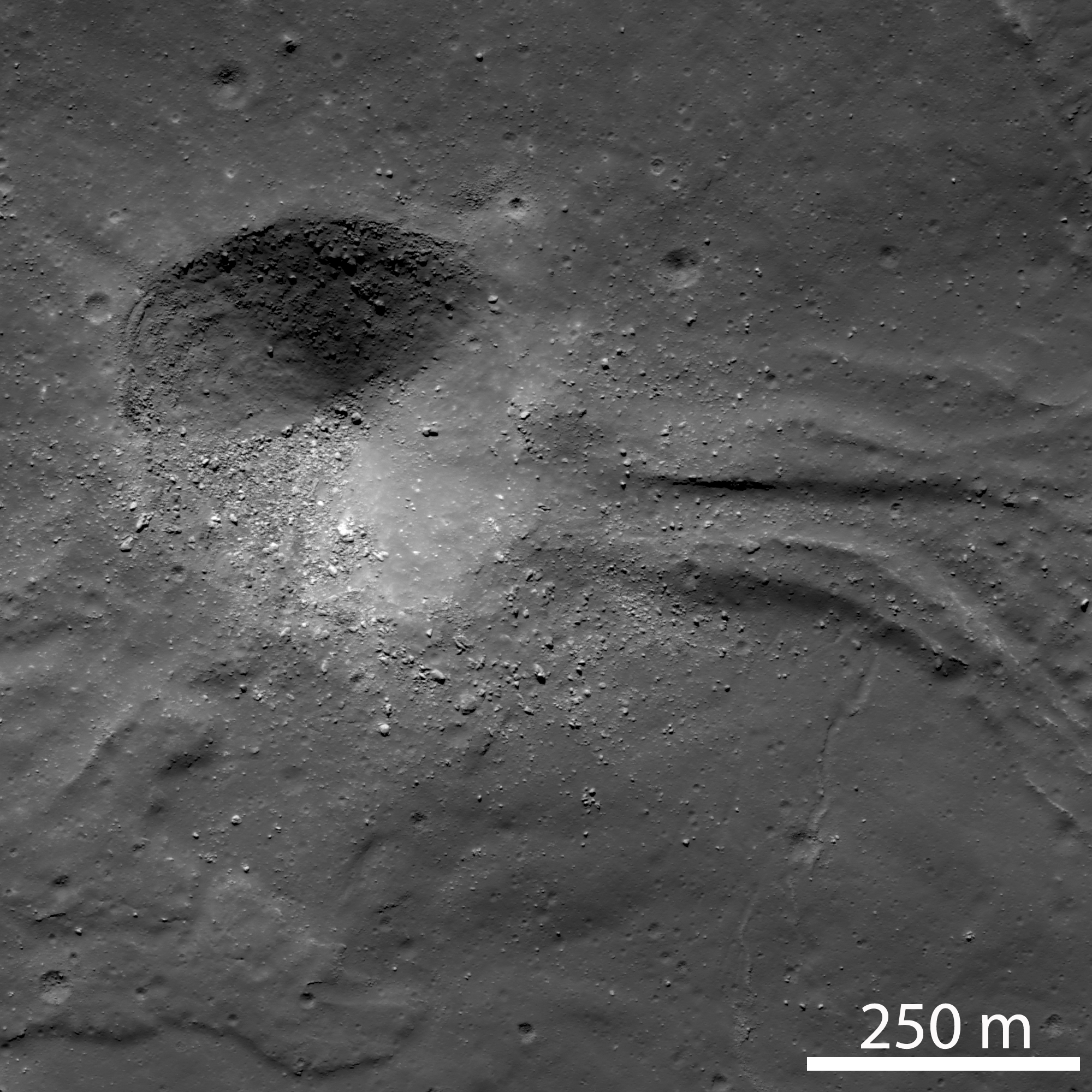
Context image of the lowest pool of impact melt, showing the locations of higher resolution images below. Cropped with depth distortion from the full size context image accompanying the LROC Featured Image, released June 20, 2012.  From a montage of the corresponding left and right frames from LROC NAC observation M181222542LR, orbit 11820, January 14, 2012; resolution 1.3 meters from 62.98 kilometers, angle of incidence 72.72° [NASA/GSFC/Arizona State University].
The impact melt flowed (A) eastward down a narrow valley from a higher pool to the west, then draining into and filling a depression at a lower elevation. To the east of the crater, the flow is about 250 m wide and exhibits a well-defined channel with levees about 60 m wide. Farther east the flow broadens into a large pool. Later a 400 m impact crater formed in hardened impact melt ejecting boulders up to 20 meters in diameter. This crater provides a great section through the flow for future geologists roaming about this geologic wonderland!

(A) A 400 meter impact crater obliterated the flow. View the original 2000 x 2000px detail, HERE [NASA/GSFC/Arizona State University].
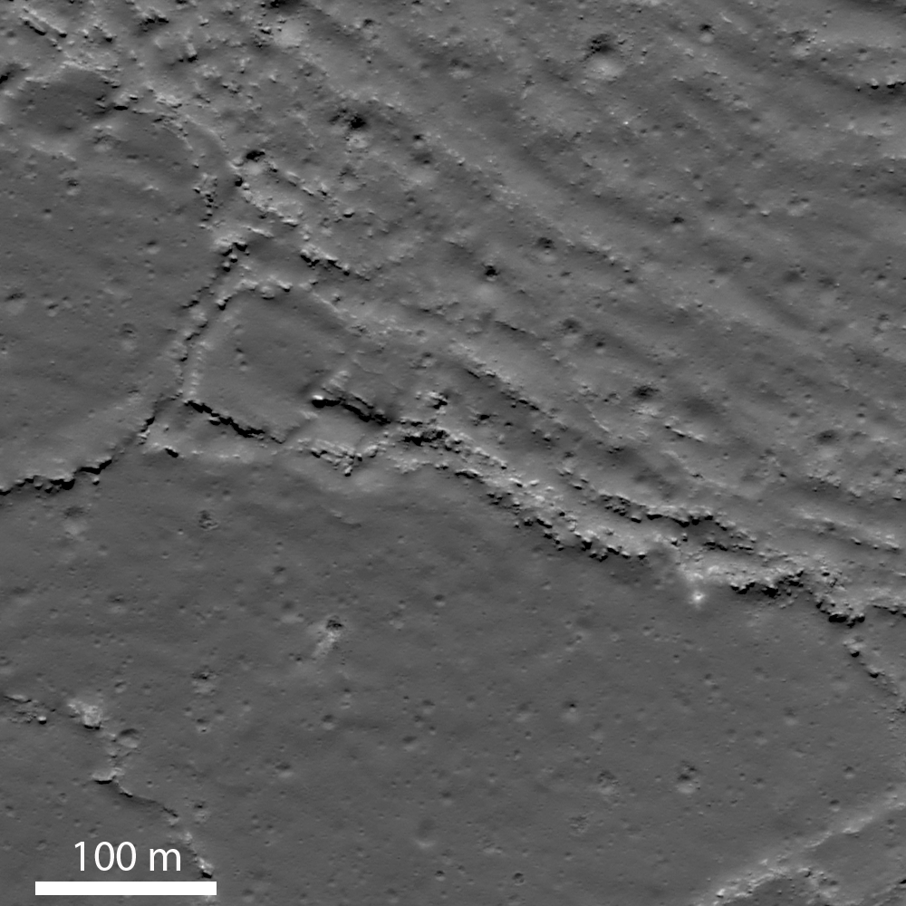
The upper right portion of image (B) shows a wrinkled flow surface with ridges spaced about 30-40 m apart; the lower left portion of the flow has a smooth surface. The two different surfaces suggest that there were different pulses of impact melt entering the pool. An initial pulse formed a relatively smooth surface, then a second pulse of melt entered the pool wrinkling part of the crust. As a crust formed on the cooling melt, continued movement compressed and deformed the surface into the wrinkled texture. Along the ridge crests, the crust has been broken up into slabs.
(B) Wrinkled and platy lava flow surface. View the 1000 x 1000px detail image, HERE [NASA/GSFC/Arizona State University].
The margin of one impact melt pools reveals a fascinating story (right hand side of image [C]). A series of northeast-trending disturbed zones, 25-50 m wide, cut the flow. The zones are likely are shear planes along which differential movement of the flow has occurred. These planes form boundaries between portions of the flow that moved laterally (to the lower left) by different amounts; the shearing movement has broken up the surface crust of the flow into a numerous small blocks. The edge of the flow is marked by a rubble zone.

(C) Shearing along the western margin of the pool. View the 1000 x 1000px detail image, HERE [NASA/GSFC/Arizona State University].
The southern end (D) is defined by a series of small lobes which probably represent breakout of still molten impact melt from the edge of the pool. The edges of the lobes are marked by plates of broken crust which presumably were rafted away from the original edge. The large lobe would have broken out from the end of the pool and flowed and broadened into a lobe about 200 m long and 300 m wide.

(D) Lobate terminus of impact melt pool. View the 1000 x 1000px detail image, HERE [NASA/GSFC/Arizona State University].
Explore the full resolution NAC frame, HERE.

Directly Related:
"Tycho's flash-frozen inferno," November 2, 2011

Related LROC Posts:
View From The Other Side
Tycho Central Peak Spectacular
Chaotic Crater Floor in Tycho
Polygonal Fractures On Tycho Ejecta

Simulated oblique view of the southeastern flank of Tycho, from "Tycho's flash-frozen inferno," a discussion of the stream of impact melt and its cascade down the rim of the 109 million year old relatively recent impact, posted here last November. Jeff Plescia of Arizona State University's Lunar Reconnaissance Orbiter Camera (LROC) science team covers the topic in more recent images and greater detail below [NASA/GSFC/USGS/Arizona State University/Google Earth]

Tuesday, May 22, 2012

Roscosmos, JAXA advocate using ISS to support extended human activity on the Moon

Paired concept of nomadic extended human sortie (Constellation-attendant) architecture envisioned within NASA before Congress, acting on the recommendation the Obama administration, eliminated development of the Altair lander [NASA/Frassinito & Associates].
Dan Leone
spacenews.com

WASHINGTON — NASA is setting its sights on an asteroid as the next big landing destination for astronaut explorers, but senior officials with two of the agency’s international space station (ISS) partners say the Moon should be the goal.

The most senior of these officials is Vladimir Popovkin, head of the Russian federal space agency, Roscosmos, who said lunar missions are his agency’s top priority for human exploration. Speaking May 22 at a roundtable of government space agency leaders at the Global Space Exploration Conference here, Popovkin said the space station partners should use the outpost to test technologies needed for a return to the Moon.

“We would like to see this phenomenal lab as a test bed that would allow us an opportunity to verify and test lots of technology that will be essential for us to be able to step up and reach deeper space,” Popovkin said through an interpreter.

Given that Roscosmos — like the rest of the world’s space agencies — faces financial and technical constraints that rule out near-term exploration of Mars or an asteroid, “we arrive at the conclusion that the Moon is supposed to be the next target,” Popovkin said. “And when we talk about the Moon, we are not talking about replicating what mankind has already achieved … we are talking about establishing permanent station bases on the surface.”

Without explicitly endorsing Popovkin’s call for permanent Moon bases, a senior official from the Japan Aerospace Exploration Agency (JAXA) agreed that space agencies across the globe should look to send human explorers to the Moon, and to use the space station to test the technology needed to get there.

The Moon “is the next destination for mankind,” said Yuichi Yamaura, associate executive director of JAXA. “We have a responsibility to continue the ISS program. That may be in preparation for human activity on the Moon.”

Read the full article, HERE.

Saturday, May 5, 2012

The new Kaguya Terrain Camera tours

Still from the 16:9 spectacular Kaguya terrain camera video tour of the Reiner Gamma albedo swirl in Oceanus Procellarum. The presentation does an excellent job showing the apparent link between the swirl and the morphology of the Marius Hill to its northwest [JAXA/SELENE].
Japan's space agency JAXA recently published a handful of spectacular, new highly realistic 3D tours from Terrain Camera data returned from SELENE-1 (Kaguya 2007-2009). Since Kaguya met its end in a guided impact visible from Earth in 2009, sporadic updates to the Kaguya Image Gallery, where mission science, presentations and a sampling of HDTV are available, have been few. 

The Japanese language side of the gallery is always updated first, so it took a little intuition for us to find the useful link to the new products. These are also comparatively large video files (20Mps MPEG, ~100 mg). Unable to view the best of these new presentations following the Flash linkage, the stand-alone files can download for viewing locally . It's worth the effort. A user can "right hand click" the links below to save the video files directly.


If you don't want to bother with all that and still want a renewed taste of Kaguya's still-unique and valuable contributions - not the least their addition to the aesthetics and appreciation for the beauty of Earth's Moon - don't neglect the Kaguya YouTube videos, starting with the famous Earthrise from 2008.

While in the neighborhood, a new and improved Kaguya terrain camera tour of the wider vicinity of the Marius pit, situated within a sinuous rille winding through the heart of the Marius Hills, is also worth the time.

Thursday, February 2, 2012

LROC: Shield Volcanoes in Lacus Veris

Wrinkle-ridges in mare basalts? Nope! These step-like features are located on the flanks of a shield volcano! (Down-slope to lower right). LROC Narrow Angle Camera (NAC) observation M166406436R, orbit 9657, July 27, 2011; field of view is 728 meters, angle of incidence 60.37° with a resolution of 0.54 meters per pixel from 48.19 km. View the 1400 px original LROC Featured Image HERE [NASA/GSFC/Arizona State University].
Lillian Ostrach
LROC News System

Although volcanism on the Moon was a prevalent process, as evidenced by the voluminous maria, volcanic constructs such as domes and cones are not particularly common. However, several regions including the Marius Hills, the Gruithuisen Domes, and the Compton-Belkovich region exhibit landforms interpreted to be volcanic constructs. Searching for similar morphologic features in LROC NAC and WAC images will help identify other volcanoes. 

On first glance, today's Featured Image may resemble another smooth region of mare with prominent tectonic features. The LROC NAC images are wonderful for studying the morphologic detail of the Moon's surface, but sometimes multiple NACs or LROC WACs are needed to grasp the "big picture" of the geology glimpsed in detail in a single NAC. In this case, we cannot rely solely on the high-resolution NAC image for interpretation of this landform, and must pair our NAC observations with a WAC context image to expand our view. Of course, imaging the whole Moon at NAC resolution would really help, too.

LROC Wide Angle Camera (WAC) monochrome context image of Lacus Veris. Located between the Inner and Outer Rook basin rings, Lacus Veris is one of several small mare deposits located within Orientale basin. Asterisk notes location (17.967°S, 274.792°E) of the opening image; black strips are present on either side of the image because the WAC image is slewed [NASA/GSFC/Arizona State University].
By using knowledge of where on the Moon the Featured Image is and then exploring the LROC WAC context image above, the landforms may be observed more completely. In the WAC mosaic, the step-like features are part of an oblong, irregular bulge near the boundary of the Lacus Veris mare material and the highland material in which Orientale basin formed. The feature is approximately 5 - 6 km wide and the illumination shows that it is topographically higher than the surrounding surface (but the WAC DTM or a NAC DTM could be used to determine how much higher the feature is from its surroundings). There is an ~250 - 400 m wide rift-like fracture or fissure down the middle of the bulge.

Crop from one of the exceptional Terrain Camera images of the area of interest from the vantage of Japan's lunar orbiter SELENE-1 (Kaguya), TC_055_3, released in 2009 [JAXA/SELENE].
These morphological characteristics are very similar to low shield volcanoes, which are formed by the same means as the Hawaiian shield volcanoes but have a much lower height-to-diameter ratio1. So, contrary to many places on the Moon, the Lacus Veris region evidently has notable volcanic constructs! The opening image is located on the distal northeast flank of the shield volcano, and probably represents multiple eruption events since successive eruptions are responsible for building the gently-sloping shields in terrestrial shield volcano eruptions.

Take a look at the full LROC NAC image; can you make observations that would help support or refute the low shield volcano interpretation?

For the seminal scholarly paper discussing this lunar shield volcano in Lacus Veris, please see R. Greeley (1976), Modes of emplacement of basalt terrains and an analysis of mare volcanism in the Orientale Basin, Proc. Lunar Sci. Conf. 7th, 2747-2759.

Related Posts:
Brayley G
Volcanoes in Lacus Mortis
Another small volcano?
Hortensius Domes - Constellation ROI

Friday, January 20, 2012

LROC Melt fractures in Jackson crater

Fractures can be seen in profuse abundance on the Jackson crater melt pond surface. Illumination from west, a field of view roughly 700 meters across swept up at an incidence angle of 71.13° LROC Narrow Angle Camera (NAC) observation M118560367L, LRO orbit 2606, January 19, 2010; resolution 0.84 meters from 52.97 kilometers altitude. View the full-size Featured Image HERE [NASA/GSFC /Arizona State University].
James Ashley
LROC News System

As molten rock cools, it shrinks and often cracks. In this case of impact melt ponded within the Jackson crater floor (22.18°N, 197.24°E), the cracking rate was so high that unfractured melt is almost more of an exception than a rule!

Radial and divergent patterns can be seen among the fracture sets that tell a story of the cooling history. The context image below shows a portion of their wider distribution.

As context for the January 18, 2012 LROC Featured Image (field of view near where the impact melt inundating the crater floor emerges from eastern wall slump; the white box) a long view north and up the steep northeastern wall, nearly to the rim, courtesy of the digital elevation model combined in Google Earth [NASA/USGS/ASU/JAXA/Google].
Overhead context for Featured Image, a field of view roughly 2.5 kilometers across from the wider LROC frame.View the full-size LROC context image HERE [NASA/GSFC/Arizona State University].
Solid objects in the melt, together with the 'shore' of the pond, appear to have influenced the way the cracks organized themselves as the melt cooled. Note how the fractures bend around or radiate from some of the positive relief features in the images above. These could be ejecta blocks or portions of the slumped crater walls in the melt that served to locally accelerate cooling. Their influence might thus be to 'seed' the stress field within the shrinking melt volume, helping some of the cracking to grow from these points, and ultimately resulting in the patterns we see today. Sagging along the shore can cause the cracking to parallel the shoreline. Any motion within the volume of melt, possibly influenced by late-stage additions of molten material, may also have contributed to the patterns observed here.

Further context, from 100 kilometers altitude, this square crop from a highly detailed HDTV still frame was captured by Japan's lunar orbiter SELENE-1 (Kaguya) in 2009 [JAXA/NHK/SELENE].
The extent and complexity of the melt pond features can be explored in the full NAC frame HERE. Additional examples of impact melt cracking include Polygonal fractures on Tycho ejecta deposits, fractured impact melt in Thales crater, and Moore F.

Ed Note: In a way opposite and contributing to the low optical visibility of the vast majority of similarly sized craters in the farside Highlands, Jackson is easier for the eye to see than most. Like Tycho on the nearside, there are a lot of craters of similar size and origin everywhere on the Moon. The difference is age. Like Tycho, the ray system of Jackson (and the materials its progenitor impact threw out) shows Jackson's "optical immaturity." To illustrate, below are two representations of the farside quadrant with the highest of the Highlands scoured by the Jackson impact, likely less than a half billion years ago.

Jackson stands out in this global montage of Clementine (1994) Ultra-Violet/Visible (UVVIS) wavelength photography designed to better map the Moon's albedo, more than a decade ago. Similar craters, basins and the Moon's highest elevations are nearly invisible [NASA/USGS/DOD].

A white arrow is needed to designate Jackson out from the pocked highlands and several otherwise invisible basins stand out with exceptional clarity in this view of nearly the same terrain as a representation of differences in elevation from the LROC Global Digital Terrain Model, developed using LROC Wide Angle Camera survey photography [NASA/GSFC/Arizona State University].

Wednesday, November 2, 2011

Tycho's flash-frozen inferno

Tycho in a full Sun, 'low phase' illumination, the crown jewel of a Full Moon on Earth has only its relative youth to distinguish it from many similarly-sized craters of similar origin. - LROC Wide Angle Camera (643 nm) mosaic from seven orbital passes (9061 - 9067) June 11, 2011. Arrow marks location of terraced pools of impact melt detailed below [NASA/GSFC/Arizona State University].
Joel Raupe
Lunar Pioneer, LLP

Hardly rare in scope or origin from similar craters all over the Moon, Tycho stands out like a bright star in the nearside southern Highlands because its bright rays radiate outward over the face of an entire Full Moon. Those rays make Tycho visible to the naked eye on Earth.

At a youthful 109 million years of age, relentless gardening by micrometerors has not yet smoothed the crater's reflective rougher edges, nor has a never-ending rain of charged particles, from the Sun and beyond, merged it's coloration into the background.Later impacts have not superimposed themselves or covered over the flash-frozen record of the mere minutes and hours following the explosive release of kinetic energy that created Tycho.

Tycho under 'high phase' illumination, at sunrise shows it's elevations in stark contrast, without the blinding albedo that tends to blur the immediate area of impact into the much broader area affected by that impact. LROC WAC mosaic, with longitude and latitude lines released by the LROC team last July. The impact melt detailed below, pooled just beyond the southeastern rim in this 130 kilometer-wide field of view, is much easier to see in the full-size original LROC image release, available HERE [NASA/GSFC/Arizona State University].
Among these finer details retained by Tycho are the pools of impact melt on the inner terraces and not far outside the crater's high rim, like the 'paved' pond Surveyor 7 nearly landed on in 1968, seen in the stark beauty of LROC Narrow Angle Camera observations.

The progenitor, the object that struck the lunar highlands and created Tycho threw up a lot of material in those first seconds afterward. Some of this material sped away at escape velocity, casually returning to the surface much later, if ever. Some sped away laterally as an immediate shock wave, carrying with it enough force to clip the tops of mountains on the south edge of Mare Serenitatis, knocking down the bright material of the Tortilla Flats in Taurus Littrow, sampled by Apollo 17 in 1972.

Some of the cloud scooped up by the blast hesitated above the area from where it was lifted and piled back down onto the surface outside the molten scar but most of the height where Tycho formed had to have been there before the explosion. We can tell this from the deep rutted channels carved into the highlands for hundreds of kilometers away from its center. The shape of the lunar surface around Tycho is not defined by what piled up but what remained after thousands of square kilometers of material were gouged away.

Tycho seems nested in a kind of plateau, though the evidence appears to show that this plateau was defined out of the highlands by the impact event that created Tycho. Great three and four kilometer-deep gullies appear to have been scooped out and away by the blast, better seen in this virtual 3D oblique view looking north over the outer southeastern rim of Tycho. LROC WAC (643 nm) mosaic as an overlay upon the Kaguya (SELENE-1) lunar digital elevation model in Google Earth [NASA/GSFC/USGS/JAXA/Arizona State University/Google].
The terraces on the inner walls of Tycho became a place for impact melt to pool and cool, so the terraces, by and large, were unlikely to have been formed by later slumping. We're left with a picture, immediately after the Tycho impact event, of a ragged scar, glowing hot in those first hours, from the central peak of deeper rock that rebounded in a heap (never higher than a crater's rim) to the very lip of the outer rim. It must have been a scene right out of Dante's Inferno.

LROC Wide Angle Camera (WAC) monochrome (643 nm) observation M119950214M, LRO Orbit 2810, February 4, 2010; resolution 66.12 meters per pixel, incidence angle 64.73° from 47.55 km. The yellow rectangle roughly outlines the field of view within the entire from of the LROC Narrow Angle Camera (NAC) frame from which scenes following originated [NASA/GSFC/Arizona State University].
Zooming in on these "Southeast Tycho" impact melt ponds, in the images above and following, note the fan of these ponds seem to flow downhill from a particularly ragged spot on the rim and apparently from further north channeled from an less distinct portion of the circumference of Tycho's rim. It's hard to imagine Tycho filled to the "brim" with molten rock, though the original melt was probably higher before it solidified to its present level. 

It's easier to imagine very hot material briefly pasted on the inside walls of Tycho sliding down to pool and form the ponds on the inner wall terraces. The ponds on the outside of Tycho are relatively sparse, but so is the slope acreage elevations outside the crater's interior. Before the anatomy of Tycho cooled and hardened some of the hottest melt was slung high seems to have collapsed like the opening rip of an ocean wave, which quickly froze, liquid rock that fossilized forty million years before the KT Boundary Extinction event brought an end to the Age of Dinosaurs here on Earth.

As impact melt briefly ran down the exterior side of the southeast brim of Tycho and pooled, coming to a halt in the cold vacuum of space long before 'finding its own level,' what appear as grooves formed by flowing molten material appear closer in to be shattered rock that instead merely aided molten transport. LROC NAC observation M150578086R, LRO Orbit 7324, January 25, 2011; resolution 71 centimeters per pixel, incidence angle 69.84° from 44.74 kilometers [NASA/GSFC/Arizona State University].
Full resolution view of the pond shore at the upper northeast in the image immediately above. The impact melt that ponded here briefly 109 million years ago was still hot enough for gas trapped within to heave bubbles to its surface. The flow at this juncture was arriving from all direction and the rounded surface tension elsewhere testifies to the lava-like viscosity of the pond [NASA/GSFC/Arizona State University].
A second full-resolution view from LROC NAC M150578086R shows where melt from the Tycho event briefly flowed down a huge, powerful fall at a high slope between ponds more than a thousand meters apart in elevation [NASA/GSFC/Arizona State University].
Tycho may be the same as many other craters on the Moon, but it's relative youth "in Moon years" makes it an easy choice for mapping the immediate aftermath of a powerful impact on an airless body, at least for the next half billion years or so.

Related Posts:
Tycho Peak Spectacular!
Chaotic crater floor in Tycho
Polygonal fractures on Tycho ejecta
Impact melt on Tycho floor
Ejecta on Tycho floor