Friday, October 9, 2009

Making an Impact (40 years ago)


Smack! - A very fresh lunar crater, from the impact of Apollo 14's 3rd Stage Saturn IVB booster, intentionally impacted into the Moon, February 4, 1971 to probe the interior structure of the Moon using seismometers left by Apollo 12. [NASA/GSFC/Arizona State University].

Mark Robinson
LROC News System

A distinctive crater about 35 m in diameter was formed when the Apollo 14 S-IVB (upper stage) was intentionally impacted into the Moon. The energy of the impact created small tremors that were measured by the seismometer placed on the Moon by Apollo 12 astronauts.

The interior of the crater has bright mounds and a bright ejecta blanket surrounds the exterior of the crater. Bright rays are observed to extend across the surface for more than 1.5 km from the impact. This image was taken when the Sun was relatively high in the sky (illumination angle of 25.1°) bringing out subtle differences in albedo (reflectivity or brightness). The Apollo 16 spacecraft first photographed this crater (Pan Camera frame 5451) and scientists noted the unusual occurrence of dark rays mixed with bright rays. Can you find the dark rays?


Apollo 14 S-IVB (S-IVB-509) was 17.8 m tall, 6.6 m in diameter, weighing ~14,000 kg. Launched carrying Apollo 14, January 31, 1971, after extraction of Lunar Module, remaining fuel was dumped and it was directed to impact the Moon February 4. [NASA Image ]

The upcoming LCROSS impact into Cabeus will also be used to probe the lunar subsurface. The Apollo 14 impact was used to send vibrations through the surface to help scientists study the internal structure of the lunar crust, the LCROSS impact will throw materials up into space so compositional measurements can be made of the subsurface from a trailing spacecraft and Earth-based telescopes.

The Apollo impact velocity was 2.54 km/sec and an angle of 69° from the horizontal along a heading of 103° (west to east). The S-IVB had a mass of 14,016 kg (30835 lbs) at the time of impact and impact energy was 5.54 x 10¹⁰ J (equivalent to just over 10 tons of TNT). The signal from the impact was recorded on the Apollo 12 seismometer; it lasted for about 3 hours. The LCROSS impactor (Centaur upper stage) is much smaller than the S-IVB and thus will make a smaller crater. The Centaur weighs about 2000 kg and will impact with a velocity of about 2.5 km/sec.

Roam around in the full NAC image comparing the S-IVB impact crater with others nearby.

Cabeus from Kaguya's Terrain Camera

The North Slope of Cabeus, released on the Japanese language side of the lunar orbiter's Image Gallery less than three hours prior to the LCROSS impact on the Moon. The full 6158px x 6078px image includes Cabeus A & B. [JAXA/SELENE]


Thursday, October 8, 2009

LCROSS Impact mere hours away

LCROSS impact area, favorably librated by the Moon's wobbly dance, reveals its underside in this image from the Tortugas 24' telescope of New Mexico State University, part of the professional side of the LCROSS Impact Observation Campaign. [NMSU/MSFC via UniverseToday]

Nancy Atkinson
Universe Today

"The LCROSS spacecraft is going to impact the Moon on Friday, October 9, and here's your chance to watch the action, either just for fun, or to contribute to scientific observations. Whether you want to observe with your own equipment or watch the event on television or a webcast, below you'll find all the information and links you should need to be a part of history. Amateur astronomers need a 10-inch or bigger telescope to make observations."

Guide to Seeing the LCROSS Impact
from UniverseToday.com

Ares I-X on-track for Rollout

Chris Bergin
NASASpaceflight.com

Ares I-X is on track to rollout of the Vehicle Assembly Building (VAB) on October 19 following the completion of several milestones and processing work relating to an issue involving 78 Upper Stage bolts. Meanwhile, the Constellation Program (CxP) have set September 2010 for a Human Lunar Return (HLR) Systems Requirements Review (SRR) summit.

Ares I-X Latest, HERE.

Mastin qualifies with Armadillo

Mastin's Xombie
Jason Paur
autopea/Wired

Another team has qualified for a $150,000 prize in NASA’s Norththrop Grumman Lunar Lander Challenge, having successfully flown its rocket lander in Southern California.

Masten Space Systems joins Armadillo Aerospace in qualifying for Level One of the Lunar Lander Challenge and the $150,000 second-place purse. Its vehicle, called “Xombie,” lifted off from a launch pad at the Mojave Air and Space Port on Wednesday. The 715-pound lunar lander prototype climbed to an altitude of 53 meters, flew horizontally for 50 meters and touched down on another landing pad during a 90-second flight.

Read the Story, HERE.

A Very Sinuous Rille

Two oxbow bends along the length of a sinuous rille located on a mare-filled crater floor. The tight twists and turns of the rille suggest that a very turbulent lava flow formed this rille. Subarea of uncalibrated LROC NAC frame M102672335L; image width is 1.56 km across and north is up [NASA/GSFC/Arizona State University].

Lillian Ostrach
LROC News System

The sinuous rille in today's Featured Image meanders, twisting and turning in very tight oxbows (the horseshoe-shaped channels), across a mare-filled crater floor. Sinuous rilles are believed to be of volcanic origin and have been the focus of both a previous LROC Featured Image and Apollo Featured Images (Vallis Schröeteri and Leveed Rille in Mare Cognitum). The tight, winding nature of this rille is consistent with erosion by a turbulent flow of low viscosity (very fluid), very hot lava. Within the turbulently flowing lava, eddies and vortices probably formed, which may have contributed to the erosion of the mare surface, creating twists that nearly touch and which rarely appear to merge (two such areas are designated by arrows). Browse the whole uncalibrated NAC Image, located to the northeast of Ulugh Beigh Crater on the northwestern boundary of Oceanus Procellarum.

Wednesday, October 7, 2009

GoogleMoon, Limited (Part Two)


The Big Tease: Two high-resolution samples of the lunar surface in GoogleMoon™ represent interesting and widely varied near side terrain thought by too many as adequately understood. Exploring these areas in the program can seem like a child's first look at pond water under a microscope. Though you won't see anything swimming around, you can go for a swim in the data.

Joel Raupe
Lunar Pioneer

The largest of two high-resolution strips in GoogleMoon combines orbital metric photography from Apollo with laser altimeter data and Terrain Camera images from Japan's Kaguya and India's Chandrayaan-1 in a six degree-wide swath through ninety degrees of longitude - a quarter way around the Moon - from 25.2°N, 331.8°E (28.2°W) in Mare Imbrium on the West to 7.8°N, 60.8°E, near Lacus Persevertantiae southeast of Mare Crisium, on the East.

A smaller 160 kilometer-square part of the Southern Lunar Highlands surrounds the Apollo 16 landing site and includes the distinctive topography of the Descartes Formation and its albedo Swirl. Finally, in GoogleMoon™ are small swaths from early Lunar Reconnaissance Orbiter (LRO) imagery of each of the six Apollo landing sites.

High-resolution laser altimetry is not weaved into these LRO images of the landing sites of either Apollo 12 or Apollo 14, making those areas unsatisfactory and two-dimensional, like the largest part of the lunar globe disappointingly represented by Clementine (1994) baseline imagery with much far lower resolution altimetry, on the whole creating a wide-rolling flat worldwide enlarged and highly pixilated photograph.

The Apollo Metric Cameras were deployed from the Service Modules of Apollo 15, 16 & 17, Apollo's science (or "J") missions. These film canisters were retrieved in deep-space EVAs during the long coast back to Earth, after leaving lunar orbit.

GoogleMoon™ does not include the full range of this Apollo photography, particularly of the far side. While confined to the sun-lit surface under orbits keeping Command Modules over the landing sites, the full range of the surface photographed from orbit covered at least ten-fold more of the surface.

Kaguya and Chandrayaan-1 altimetry, if not their terrain cameras, covered the entire Moon.

Hopefully GoogleMoon™ developers await data gathered by LRO and a future roll-out of GoogleEarth™ (v.6) for a more complete coverage of the rest of Moon. Putting together what they have must have been a lot of work.

The high-resolution that is available in GoogleMoon™ is represents thousands of square kilometers of detail in context, allowing a human perspective of what would otherwise simply be a flat-file of numbers.

Devoted lunatics are now allowed an opportunity to "see it like a native," and to classify some newly-resolved features invisible using the best telescopes on Earth.


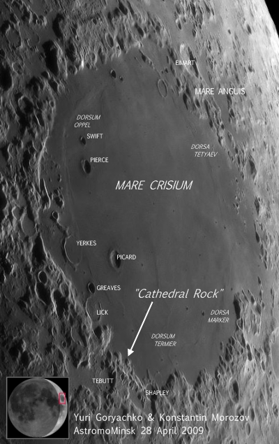
'Cathedral Rock,' a collis, a "hill or knob" according the USGS Gazetteer of Planetary Nomenclature, and a word used to distinguish a feature not generally associated with the Moon. From laser altimetry and topography from Japan's Kaguya, dovetailed into Apollo photography, it now appears certain families of colles may become as readily associated with the Moon as are other features with familiar Latin names, like "lacus" for lake or "dorsa" for wrinkle ridges.

This is the largest example of what evidence indicates is a common feature in certain locations on the Moon.

The collis 'Cathedral Rock' is apparently one in a family, sharing distinctive characteristics. In the picture immediately above, like Medieval siege engines rolled to the edge of a city wall, 'Cathedral' stands not far from two smaller family members, off in the distance. The view is from a perspective slightly above the basin floor aimed to the southeast, along a small part of the massive Crisium rim.

We're very unofficially calling this family of colles the "colles arduum," because of the arduous work needed to get to their top. These seem to be a common sight where the basin's lava-flooded interior basin butts up against its inner ring. Crisium formed through a cataclysmic impact 3.92 billion years ago, but aside from globe-shaking moonquakes that have occurred throughout that long period, bringing material down in repeated slumps from the heights beyond, this family of colles have looked much as they do today during all that time.

On Earth such formations would immediately be guessed to be the result of wind and water erosion but these colles are made of some pretty tough stuff, perhaps at its hardest along the length of its spire.

These features are dark, when found in the Apollo images, as well, indicating a very long period of optical maturity and at least 900 million years of exposure to the sun.

Perhaps the colles are fumaroles, formally within the crust that was blown away from the center of the Crisium impact 200 kilometers away. We note that the colles seem common along this basin wall but we have also found similar collis deep within basin's interiors.

The base of collis "Cathedral Rock" (10.81°N, 54.32°E) is around a kilometer across and irregularly shaped. Like other members of its family there is also is is a secondary ridge on top of this, running length-wise. And from the end of the secondary ridge that is furthest away from the Crisium ring behind it is the landmark spire rising almost to a point.

The inner ring of mountains surrounding Crisium seen behind the tower rises another kilometer and a half above the basin to the left, itself around 3,500 meters below the Moon's mean elevation. The top of the Cathedral's spire is 1,500 meters above the basin. Further along to the east-southeast the basin's steep wall reaches above 500 meters, adding up to a difference in elevation of at least a 4 kilometers within a two to three kilometers walk.

And this is pretty average and not record-breaking for the Moon or Crisium.


'The Boys from Minsk' - That's what Charles A. Wood, proprietor of the Lunar Picture of the Day (LPOD) web repository casually calls the astrophotographers publishing some breathtaking, painstakingly-created and state-of-the-art lunar photography work using the name Astromominsk. It would be unfair to say their work is 'the best' but it easily ranks in the top ten on Earth. These days professional astronomers largely confine their time on the Great Telescopes to stars and galaxies. Institutional telescopes are almost too sensitive for the relatively brilliant objects in the neighborhood, especially the large and "familiar" near side of the Moon. Meanwhile people like Yuri Goryachko & Konstanin Morozov, along with a small number of others throughout the world, are using modern instruments and CCDs to image regions of the Moon in high-definition and then assemble these into astounding mosaics, creating the the best images of the Moon available from Earth. There may not be a single "best" image of Crisium by there individuals and small teams. Like everywhere else on the Moon Crisium reveals its secrets under favorable lighting, almost always when the phase of Sun, Moon and Earth, along with lunar libration, cast sunlight on the landscape in sharp relief, bringing into view some features dwarfed by their shadow, at no other time during lunar orbit.

We decided to verify Cathedral Rock because we wanted to investigate the usefulness of GoogleMoon, as a legitimate tool of exploration.

In a preliminary search through the best lunar photography taken from Earth we began with the many excellent images of Crisium contributed by scientist-artists to Charles A. Wood's Lunar Picture of the Day.

In the end we chose a mosaic referenced there and composed from 9 images of a Crescent Moon last April, assembled by Yuri Goryachko & Konstanin Morozov.

The image immediately above was ripped from that mosaic.

The tip of the arrow designates an apparently empty spot near a tiny peninsula, meandering north (top) 15 kilometers or so into Crisium from its surrounding inner ring. It is the precise spot where we found Cathedral, and the face of the range immediately behind it in the second image from the top of this article is part of the small peninsula above. It looks very small 400,000 kilometers away, but the tip of the arrow points at what looks like more basin floor.

At this point we decided to pause to ask ourselves one very simple question.

Is it real?

Mons Hadley Delta (Kaguya Terrain Camera TC-008). Instead of trying to prove Scott and Irwin of Apollo 15 really explored the edge of Hadley Rille in 1971, scientists at JAXA used the Kaguya Terrain Camera to generate the perspective seen on the left and compared it with AS15-82-11122HR, a photograph taken from the location during Apollo 15's first EVA, July 31, 1971. (The Kaguya Terrain Camera image was released June 13, 2008) When compared in full, the high-resolution compilation in GoogleMoon™ is better, even without the strip of LRO narrow-angle camera covering a lot of the same terrain. What is missing, even from LRO imagery of the region, is granularity. LRO's resolution from its present 53 km orbit eight tenths of a meter per pixel. [Kaguya Image Gallery, NASA/JAXA/SELENE]

It's important to know if Cathedral Rock is really there.

If it is a powerful tool for lunar exploration has been made available to a very large group of devotees.

GoogleMoon™ can't be a substitute for other tools of exploration and analysis, but it may present a powerful answer to a problem recently posed by Apollo veteran and geologist Dr. Harrison H. "Jack" Schmitt. He has noted a big problem presents itself in the sheer size of the data collected by a the small, but very sophisticated fleet of 21st century probes; China's Chang'e-1, Japan's Kaguya, India's Chandrayaan-1 and the Lunar Reconnaissance Orbiter from the United States. The depth of these data presents scientists with a formidable analytic and cataloging nightmare.

Ten years after Lunar Prospector de-orbited into Shoemaker Crater, near the lunar south pole, scientists still work and tweak data that the $60 million orbiter returned, and they are still discovering new things. Chandrayaan and Kaguya returned datasets that dwarf what was returned from earlier missions, and nearly as much information has already been returned from LRO after barely more than 110 days into its mission.

Is one solution to the problem of slow assimilation and analysis of these data standing right in front of our eyes?

Years into the Age of Video Games, with virtual worlds made three-dimensional with ray-trace animation, it's prudent to examine whether a feature like Cathedral Rock is just repeated landscape, like virtual trees repeated over and over in a Flight Simulator landscapes, patterns within an otherwise realistic landscapes that are just 'filler.' There are other families of colles that share strikingly suspicious similarities elsewhere in the high-resolution corridor in GoogleMoon™, and we will discuss these in Part 3.


HTML clipboardUnlike the deceptively smooth basin floor imaged from Earth, this photograph from the Metric Camera on-board Apollo 17, looking almost in the opposite direction, shows Crisium's floor to be a very tortured place. Greatly enlarged from the image available at Arizona State University, but still nearly invisible without considerable adjustments, something is definitely seen where GoogleMoonclaims it to be [Lunar Pioneer/GSFC/LPI/ASU].

Tuesday, October 6, 2009

'Once more around the Earth,' the final orbit of LCROSS


Ed. Note: The Moon looms large in our sky, but it's a hard target, literally, but especially if you've been crossing it's orbit at the distance from Earth where it will be this Friday morning, over and over, since July. And it is on Friday that the Moon, specifically the crater Cabeus, will be directly in LCROSS Flight Director Paul D. Tomkins' path, as no accident.

If all goes well, and it should, it will be no good luck alone enables Tompkins and his team to bid nearly instant goodbye to their spacecraft, first to the impacting Centaur, watched faithfully for around four minutes by an array of sensors aboard the separated Shepherding and Sensing satellite which will swiftly follow down its own path to destruction.

As we wait, now might be an excellent time to read Tompkins' own history-making final orbit of the LCROSS experiment.

(Since uploading the diagram below, in little more than a day LCROSS has accelerated a full third of the way closer to the Moon than Tompkins' yellow triangle indicating the LCROSS Current Position. Also, this last orbit began with a fuel leak 'anomaly,' undiscovered until it became a threat to the mission. The Flight Director picks up the story from there.)


Paul D. Tompkins
LCROSS Flight Director's Blog

The anomaly robbed the LCROSS Flight Team of precious time to prepare for Impact. But with a healthy spacecraft, and enough propellant to do the job, our team was all too happy to prepare for the future. Ahead of us were five more Trajectory Correction Maneuvers (TCM 6 – 10) to precisely refine our crater targeting, then Separation, Centaur Observation, Braking Burn, and finally, Impact. In the midst of our TCM series, the Science Team continued refining their selection our target – the specific crater, and the point within the crater - based on the latest data from other missions. As a final confirmation of the payload instruments, the Science Team also wanted to look at Earth one last time before Impact. On top of all that, we needed to practice those final two critical days as much as we could.

Continue Reading the Post, HERE.

Senator Shelby 'slams' Augustine panel

Mark Matthews
The Write Stuff
Orlando Sentinel


In a forceful floor speech, Alabama’s senior senator defended NASA’s current plan to return astronauts to the moon and jabbed the recent findings of a presidential space panel tasked with evaluating the agency’s troubled Constellation program.

“While I commend the Augustine Commission for their hard work, I find many of the aspects proposed in their summary report to be unsatisfactory and disappointing,” said U.S. Sen. Richard Shelby on Monday, referring to a 10-member space panel led by retired Lockheed Martin CEO Norm Augustine.

Read the Post, HERE.

Far Side Borderland Landing Site

Edge of Mare Moscoviense. Image width is 1.4 km

Samuel Lawrence
LROC News System

Mare Moscoviense is a one of the many places on the lunar surface that lunar scientists want to visit. The lunar farside is quite different from the nearside; one of the bigger reasons why is that the mare basalt deposits so common on the nearside are few and far between on the farside. Since basalts form by partial melting of the lunar mantle, sampling Moscoviense basalts would provide lunar scientists with vital insights into how the lunar mantle on the farside differs from the nearside mantle, which in turn would help us to learn why mare basalts are so much rarer on the farside.

For these reasons, Moscoviense is one of the sites identified by NASA's Project Constellation as an important site for possible future human lunar exploration. This LROC NAC image shows the view of a region several kilometers south of the proposed Exploration site, including a boundary between the mare basalts in southern Mare Moscoviense and the surrounding farside highlands. The white arrows show the location of a "bathtub ring" indicating the level that the original lavas reached as the Moscoviense basin fillled with lava. As time progressed, the erupted lavas gradually drained out of the basin, eventually solidifying at the current lower level. Human exploration of this area in particular would provide contextualized samples of the Moscoviense basalts and samples of the surrounding highlands materials, providing key and otherwise unavailable insights into the geologic history of this region.

(Browse the whole NAC image.)

Ad Astra tests world's most powerful ion engine

From David Shiga
New Scientist-Space

"Since 2005, the Ad Astra Rocket Company of Webster, Texas, has been working to perfect a type of engine it calls VASIMR (Variable Specific Impulse Magnetoplasma Rocket)."

"Now, the company has run such an engine at full power for the first time. On Wednesday, it ran its VX-200 engine at 201 kilowatts in a vacuum chamber in Houston, passing the 200-kilowatt mark for the first time."

"It's the most powerful plasma rocket in the world right now," says Franklin Chang-Diaz, the former NASA astronaut who heads the company."

Read the story, HERE.

Texas congressional delegation wants 'Stimulus' money for NASA

Stewart M. Powell
Houston Chronicle

Texas' top lawmakers in Congress want President Barack Obama to pony up some of the $787 Billion in economic stimulus money to rescue NASA's manned space program and ensure that astronauts one day will travel beyond the orbiting International Space Station.

Twenty-eight Republican and Democrat members of Texas 34-member delegation, led by Republican Sens. John Cornyn and Kay Bailey Hutchison, delivered their appeal by letter on Monday, days before Obama is expected to hear a White House panel of experts recommend greater spending.

The lawmakers asked Obama to divert $3 billion from the unspent portion of the economic stimulus package that continues to be doled out as part of an economic recovery plan stretching over two years.

Read the analysis, HERE.

India (ISRO) looks to space tourism, examining help from Russians

In addition to partnering with the Russian Federal Space Agency (Roscosmos) to build Chandrayaan II, India's lunar lander and rover follow-up to Chandrayaan I, the Indian Space Research Organisation (ISRO) is reportedly reaching out to Russia hoping to start a space tourism venture.

From Space.com, via TG Daily:

Andrew Thomas

ISRO wants to buy non-reusable Soyuz TMA spacecraft and sell two of its three seats to fare-paying passengers. The value of the potential deal was not revealed.

"ISRO has applied for acquiring a spaceship for space tourists," said Russian space agency Roscosmos spokesman Alexei Krasnov, who added that the deal would be purely commercial and that the Soyuz would probably be piloted by a Russian cosmonaut.

Roskosmos currently charges about $35 million for a ten day tourist flight to the International Space Station. Moscow and New Delhi signed a space agreement last year, under which Russia will help ISRO in training Indian astronauts and provide technical backup enabling India to build its own manned spacecraft.

ISRO already has launch vehicles under development which could carry the Soyuz craft into orbit.

Read the story, HERE.

Grumbling over sub-orbital tourism delays

From Lunar Pioneer
Heath Haussamen
New Mexico Independent

It’s been five years since SpaceShipOne won the first Ansari X Prize and proved that commercial vehicles have a future in outer space. But the move to actually commercialize space hasn’t been as quick as those trying to make it happen predicted.

The Associated Press takes a look at that reality in a new article featuring “daredevil venture capitalist” Alan Walton who says he’s about ready to ask for his money back if there’s no set launch date by next April, when he turns 74.

“This was going to be the highlight of my old age,” the AP quoted Walton, one of hundreds of people who “plunked down” the $200,000 to be among the first space tourists on a Virgin Galactic spaceship.

When Virgin officials and the state of New Mexico came together to announce a partnership to turn the commercial space industry into a reality, they estimated commercial flights beginning in 2007 in California and moving to Spaceport America as soon as the New Mexico facility was ready in 2008.

Clearly, that hasn’t happened. Commercial flights in California haven’t started yet, as Virgin has experienced as many delays in building its craft as New Mexico officials have had in building the spaceport.

Read the feature story, HERE.

Jacobs gets 3 year, $973 million NASA contract extention

Dow Jones Newswire

Jacobs Engineering Group Inc. received a three-year extension of its engineering and science contract with the National Aeronautics and Space Administration at the Johnson Space Center.

The $978 million extension at the Houston facility, one of seven current contracts with NASA centers, calls for the engineering consulting company to provide various services related to the International Space Station, the final space shuttle flights and the next-generation Orion spacecraft.

The contract's value is now $2.16 billion as it gets extended to eight years. Jacobs has various subcontractors for the Johnson Space Center work.

ATK pink-slips 550

ATK Space Systems division undergoing preparations for test of
new five-segment SRB for Constellation Ares, last July

Paul Foy
(AP)

Salt Lake City — The phase-out of the space shuttle program brought 550 layoffs on Tuesday to a Utah company that makes the booster rockets.

ATK Space Systems said it was handing out pink slips to engineers, factory workers and others at three Utah locations.

AP full story, HERE.

LCROSS Impact on NASA-TV

LCROSS Lunar Impact
7:31 a.m. EDT/4:31 a.m. PDT
Friday Oct. 9

An approximately 1.5 hour Live NASA TV Broadcast is planned for the LCROSS impacts starting at 6:30 a.m. EDT/3:30 a.m. PDT, Oct. 9, on NASA TV and www.nasa.gov/ntv.

The broadcast includes:

* Live footage from spacecraft camera
* Real-time telemetry based animation
* Views of LCROSS Mission and Science Operations
* Broadcast commentary with expert guests
* Prepared video segments
* Views of the public impact viewing event at NASA Ames
* Possible live footage from the University of Hawaii, 88-inch telescope on Mauna Kea.

The live LCROSS Post-Impact News Conference will be 10 a.m. EDT/7 a.m. PDT on NASA TV and www.nasa.gov/ntv.

'Trash can-sized' nuclear reactors to power lunar habitat

Marshall's one of a kind test facility enabled engineers to simulate the nuclear power process of heat transfer from a reactor to a power converter. Boise Pearson (Left), Team Lead for Fission Surface Power Test Facility and Mike Houts Project Manager for nuclear systems at Marshall review test results on the Stirling engine. Kurt Polzin, research scientist is shown in background. [E. Given -NASA-Marshall]

Janet Anderson
NASA Marshall SFC

Huntsville - NASA has made a series of critical strides toward the development of new nuclear reactors the size of a trash can that could power a human outpost on the moon or Mars.

Three recent tests at different NASA centers and a national lab have successfully demonstrated key technologies required for compact fission-based nuclear power plants for human settlements on other worlds.

NASA's Marshall Space Flight Center in Huntsville offers a one-of-a-kind test facility which, without using nuclear materials, enables engineers to simulate the nuclear power process of heat transfer from a reactor to a power converter.

"The recent tests bear out that Fission surface power system could be an important source of energy for exploration on the moon and Mars," said Mike Houts, project manager for nuclear systems at Marshall. "This power system could provide an abundant source of reliable, cost-effective energy and may be used anywhere on the lunar surface."

For this particular test series, the Marshall reactor simulator was linked to a Stirling engine, developed by NASA’s Glenn Research Center in Cleveland. The Stirling engine, named for 19th-century industrialist and inventor Robert Stirling, converts heat into electricity.

The Marshall reactor simulator included a specialized pump, provided by the U.S. Department of Energy, and a coolant loop filled with a mixture of sodium and potassium. The coolant loop provided heat to the Stirling engine at conditions very similar to an actual fission-based surface power system. The joint testing helped resolve potential integration issues and provided information and experience needed to reduce technology risks associated with this system concept.

The testing of the Stirling engine with the Marshall reactor simulator may well be a key factor in demonstrating the readiness of fission surface power technology, and could provide NASA with an efficient and robust system to produce power in the harsh environment on the moon and Mars.

NASA's current plan for human space exploration is to return astronauts to the moon by 2020 on expeditions that could lead to a permanent outpost for exploring the lunar surface and testing technologies that could aid a manned mission to Mars.

The space agency has been studying the feasibility of using nuclear fission power generators to support future moon bases. Engineers performed tests in recent weeks as part of a joint effort by NASA and the Department of Energy.

Nuclear fission power plants work by splitting the nuclei of atoms in a sustainable, controllable reaction that releases heat, which can then be funneled through a power converter to transfer that energy into usable electricity.

"A small fission-based nuclear reactor coupled with a Stirling engine could provide up to 40 kilowatts of usable energy, enough to support a moon base or Mars outpost," said Houts. That's about the same amount of power needed to supply eight houses on Earth, NASA officials have said. The test series was conducted as part of the fission-based surface power project, within NASA's Exploration Technology Development Program, which is tasked with developing advanced technologies that will enable NASA to conduct future human exploration missions, while reducing mission risk and cost.

The next step for NASA's fission power project is to combine its radiator, engine and alternator successes into a single non-nuclear power plant demonstration. That test is slated to begin in 2012, NASA officials said.

For more information about NASA’s Exploration program, visit:

http://www.nasa.gov/centers/marshall/news/news/releases/2009/09-009.html
http://www.nasa.gov/centers/glenn/news/pressrel/2008/08-042addm.html
http://www.nasa.gov/centers/glenn/news/pressrel/2009/09-036_fission.html

Monday, October 5, 2009

LCROSS Week

CABEUS: The Moon will seem to have lifted its 'chin' slightly, wobbling through a favorable libration to give those on Earth a better view, early Friday morning, Oct. 9. At 11:31:30UT (7:31 am EDT) the "SUV-sized" centaur upper stage will impact the Moon. Following closely behind, only 400 kilometers and four minutes behind, the smaller, ingeniously designed shepherding and remote sensing satellite will survey the resulting plume in all of the various wavelengths looking for hard evidence of water, streaming data back to Earth in realtime until it, too, impacts nearby, at 11:35:45.

Stephen Clark
Spaceflight Now

An enterprising robotic explorer will smash into the lunar frontier Friday in search of water ice hidden deep inside the darkest corners of the moon, spewing hundreds of thousands of pounds of dust high above the surface in a celestial event visible from Earth.

Just four minutes will decide the outcome of three years of preparations, four months of space travel, and a $79 million investment put into the bold mission.

Read the Story HERE.

Saturday, October 3, 2009

GoogleMoon, Limited (Part One)


Glancing back at Vallis Lorus as seen from an eastern extreme up on the north side of the "lobe" rising between Rima Sung Mei (the shallow fissure with darker material moving off to the northeast and out of view) and Rima Krishna (to the left, and eclipsed by the lobe) over-looking a uniquely-shaped lunar valley in the western Mare Serenitatis.

Larger than it might appear, the western extreme above center is approximately 5.5 km away, and the deepest point in the valley floor, just barely out of sight below, falls away more than 300 meters below this "virtual" vantage point made possible by GoogleMoon. This close-up is combines Apollo science photography with laser altimeter data from Japan's Kaguya (SELENE-1) mission (2007-2009). [GoogleMoon/ASU/NASA/USGS/JAXA]

GoogleMoon, a virtual world within GoogleEarth, provides arm-chair lunar explorers a long-awaited way of experiencing the "ground truth" on our nearest neighbor, the chance to see vistas from the surface as only an astronaut can, though no astronaut yet has. There are limits to the availability of data from the latest international fleet of 21st century probes, however, presenting a slight problem to GoogleMoon users, while hinting at a solution to that problem that GoogleMoon might eventually provide.

Joel Raupe
Lunar Pioneer

Before long, you or an astronaut (or a taikonaut; some kind of Human Being, in any case) will stand and survey Vallis Lorus from it's eastern rim. I took a stroll there today, not just without my helmet but without my spacesuit. And this took far less effort than setting up my telescope and waiting for one of only two viewing opportunities each month - six days after a New Moon or five days after the Moon is Full - all the while wishing for a cloudless sky.

I took the picture (screen capture) above soon after hungrily devouring the latest "featured image" released by the LROC News System at Arizona State University.

Though this doesn't yet rival the unparalleled detail in Mare Serenitatis seen from Lunar Reconnaissance Rover (LRO) last August, it's pretty close to the perspective you or I might see standing on the Moon at this spot, or at least what I might see without my glasses.

The Japanese Space Agency (JAXA) demonstrated the potential when combining Kaguya laser altimeter and Terrain Mapping Camera data in 2008. Photographs taken from the ground by Dave Scott and Jim Irwin (Apollo 15) from edge of Hadley Rille with St. George Crater at the rille bend at the foot of the Montes Apenninus were juxtaposed against a similar perspective within a computer-generated virtual presence at the same location, and they matched perfectly. This offered best evidence to date that Scott & Worden were actually on the Moon in 1971, and showing the same scene captured by the color television camera mounted on their Rover.

The only thing missing was the kind of "edging," the smaller-grained material, small rocks and differentiated boulders, boot prints and dust now coming in from LRO. This is almost the same experience available today, in relatively small and narrow areas of the Moon, if you have GoogleEarth (v.5 and above).

Aside from the landing sites for Apollo 15 and 17, yesterday's featured release from LROC, highlighting Vallis Lorus ("Aratus CA," Oct. 3), is the first from LRO in the Apollo science-mission, high-resolution photography corridor of GoogleMoon, a strip of near side surface roughly 150 km wide stretching over 2700 km from southeast-central Mare Imbrium on the west to the south side of Mare Crisium on the east.

It's a good start but GoogleMoon won't really be fully released, as heralded in celebration of the 40th anniversary of Apollo 11 last July, until this same depth of resolution covers the entire virtual Moon.

While the Apollo science imagery, from Apollo 15, 16 & 17, did not cover the whole Moon it did cover much more than that featured in GoogleMoon at present. Even the lower resolution photography elsewhere in GoogleMoon would be vastly improved with the addition of Kaguya altimetry or, perhaps better still, LOLA laser altimetry from LRO.

The gently sloping terrain everywhere else but what is found within the single Apollo corridor or at the landing sites (probably altimetry from Clementine gathered in 1994, has a "here there be dragons" feel. It's bound to be a disappointment to young, would-be lunar explorers who want to scale Rupes Recta or the heights of the far side.

Finding out why GoogleMoon's developers stopped where they did, or more importantly if there are plans to complete the project in a timely fashion has proven to be elusive, though we are still trying and would welcome suggestions.

In the meantime, the astounding experience of exploring those areas within the high-resolution scenery is actually yielding new discoveries, and it is offering what might be a solution to a thorny problem patiently outlined by Dr. Harrison Schmitt. It's a solution to a problem which might also be at the root of why serious GoogleMoon explorers find themselves confined to restricted areas.

I will outline just what we mean in the next installment.


Ben Bova: Investing in space would stimulate earthbound economy

Ben Bova
Naples Daily News

The old adage says, “You pay your money and you take your choice.”

But when it comes to the space program, Washington most often makes its choice first, and then cheaps out on paying the money for it.

This is the major point of the report recently issued by the committee reviewing NASA’s plans for human space flight. The committee is headed by Norman Augustine, of whom I wrote a couple of weeks ago.

In typical Norm Augustine fashion, the report starts with a bang:

“The U.S. human spaceflight program appears to be on an unsustainable trajectory. It is perpetuating the perilous practice of pursuing goals that do not match allocated resources.”

President Barack Obama says he wants to support NASA’s plans for returning humans to the moon by 2020 and building permanent bases there, then going on to send human explorers to Mars, goals that were established by the previous administration.

But there’s another old adage that applies here: “Put your money where your mouth is.”

Read the rest HERE.

Aratus CA


Subset of uncalibrated LROC NAC frame M104447576R showing Vallis Lorca, one of four lobes that make up Aratus CA in western Mare Serenitatis near the Montes Apennius. The Sun is shining from the lower left, image width is 1924 meters [NASA/GSFC/Arizona State University].

Sarah Braden
LROC News System

"Aratus (CA) is an unusual depression and possible volcanic vent, previously featured in the Apollo Image of the Week. This depression is about 9.5 km long and 3 km wide, located at the termination of a north-south trending wrinkle ridge known as Dorsum Owen. After the mare lavas erupted and cooled, contractional tectonic forces generated wrinkle ridge features. Most lunar scientists think this unique depression is a product of both volcanism and tectonic collapse. Each lobe is distinct, for example, Vallis Lorca is a collapse pit crater, while the lobe to the east named Rima Sung-Mei is a small rille. Stratigraphy and cross-cutting relationships indicate multiple tectonic and volcanic events. The featured image of the Vallis Lorca lobe shows “rings” around the rim, indicative of collapse. Browse the whole NAC image."


1.5 m/pixel resolution of this NAC image allows for a detailed view of layered outcrops of mare basalt in the southern wall of Aratus CA. Image width is 1480 meters [NASA/GSFC/Arizona State University].

Friday, October 2, 2009

Surprise Augustine Committee hearing set

Robert Block
The Write Stuff
Orlando Sentinel


The Review of U.S. Human Space Flight Plans Committee will hold a public teleconference on Thursday, Oct. 8, from approximately 1 to 2 p.m. EDT.

The only topic for discussion will be finalization of scoring of options the committee presented in their summary report on Sept. 8. This meeting will be held by teleconference only. The teleconference will be open to the public. The service limit is approximately 300 dial-in callers. Public participants will be in a listen-only mode.

Read the post, HERE.

Space Coast sees first big round of KSC layoffs

Cape Canaveral — The first round of what are expected to be thousands of layoffs of space-program workers starts today, Friday, with 258 shuttle contractors losing their jobs in anticipation of the space shuttle's retirement next year.

In addition, nine employees of rocket-maker United Launch Alliance also received pink slips Thursday, along with about 70 security workers at Cape Canaveral Air Force station.

The 337 layoffs are the first of what local officials estimate will be 7,000 space-program job losses by the end of 2010.

The 258 shuttle workers were employed by United Space Alliance, which services the shuttle for NASA, and most volunteered to leave. About 20 more will be leaving next week.

Read the post, HERE.

Augustine Committee report two weeks away

According to a report by Shelby Spires at the Huntsville Times, the long-awaited final report by a presidential space panel about the future of NASA and human space flight is unlikely to be sent to President Barack Obama until the middle of October.

Read the post HERE.

Space Investment Summit

William Watson, executive director of the Space Frontier Foundation, took part in the Space Investment Summit. (Michele McDonald - The Boston Globe)

Sean Teetan
Boston Globe

Rocket ships and outer space conjure up images of shuttle launches, moon landings, and the wonders of the unknown beyond Earth’s atmosphere. But for about 130 attendees of the Space Investment Summit yesterday at the Hynes Convention Center, these things are just business as usual.

The summit, which came to Boston for the first time since it started in 2007, gives entrepreneurs with space-related ideas an opportunity to try to convince prospective investors that their ideas are more than science fiction fantasies, but rather the next big thing.

Read the Story HERE.

US 'red tape' dogged Chandrayaan - BBC

"The recent discovery of water on the Moon by India's inaugural lunar mission almost never happened because of a twin helping of good old-fashioned red tape and lingering Cold War suspicions, reports science writer Pallava Bagla."

Read the Story HERE.

Regolith simulant explored in Montana

USGS project geologist Doug Stoeser looks through a huge pile of waste rock from the Stillwater Mine in Nye Wednesday afternoon. Stoeser is working in conjunction with NASA to find the perfect combination of minerals from mine waste to closely simulate a lunar surface to prepare for future moon explorations.

Clair Johnson
Billings Gazette

"Stephen Wilson, a USGS research chemist from Denver, said the agency knew where to find the material NASA sought. "Oh, go to the Stillwater,'' he said. "The Stillwater is one of the unique places that can do it. What is waste rock for the Stillwater mine is exactly what we want.''

"USGS began collecting the rock samples for testing in 2007 and so far has made five trips to the mine site. Wilson said it took two trips to find an outcrop -"a big block of really great rock''- that appears to have a higher grade of minerals. Another source of the regolith material is in the waste rock dug from the mine to get to the platinum-bearing ore.

"So far, USGS has collected 20 tons of Stillwater rocks and has processed 4 tons into regolith in Denver, Wilson said. The project is in the early phase, during which USGS is sampling and testing the rock for quality and consistency and to learn "what will and what won't work,'' he said.

"While artificial regolith has been made before, the new material is "unprecedented'' in its complexity and similarity to the regolith found at moon's southern pole, USGS said."

Read the feature story HERE.

Thursday, October 1, 2009

Lonely Sentinel Abides


Surveyor 1
- Compare this inset, lifted from an image swept up by the Narrow Angle Camera (NAC) on-board the Lunar Reconnaissance Orbiter (LRO) over Oceanus Procellarum (M102443995L - Orbit 272, 17 July 2009) last Summer, with the image from Lunar Orbiter III (III-194-H3 - miraculously restored by the Lunar Orbiter Image Restoration Project (LOIRP) and released 11 Sept.) photographed originally on 22 Feb. 1967.

LOIRP's restored image from Orbiter III was just referenced here two days ago ("Lonely Sentinel," 07:28, 29 Sept. 2009).

Forty-three years after landing on the Moon America's first lunar lander seems none the worse for wear though it might (or might not) seem a little "dusty." That's likely an illusion since the Sun's rays on the landing site were arriving from a direction opposite that seen by LO III back in February 1967.

It's important to find out if it is even a little dusty, though. Because, unlike Mars, there is no native wind to blow dust around on the Moon. For it's finest sub-micron sized silica shavings, though, there is something else. Charge particles from the Sun, mostly, along with cosmic rays, and a warp and woof of magnetic fields from Earth's magnetotail, the Sun's interplanetary field and, here and there, lunar magnetic anomalies in the crust of the Moon, some strong enough to shield the surface within them from solar wind and fallout, all of whom may interact with those tiny particles. Appearances aside though, the Moon's incredible and enduring history of bombardment (conveniently, perhaps, at precisely the same place in the solar system occupied by Earth) is faithfully recorded in billion-year units.

It's been estimated that it takes a mere two million years for the top few millimeters of the lunar surface to be reworked, or "gardened," by micrometeorites. Forty-three years on the Moon shouldn't change things very much, as borne out by forensics done on artifacts removed from Surveyor 3 by Conrad and Bean (Apollo 12) in 1969.

This little squat, three-legged aluminum vehicle built by Hughes Aircraft and operated by the Jet Propulsion Laboratory, once handled by Eugene Shoemaker, is not just an interesting relic of "cultural" significance.

It's important to remember Surveyor 1 is, by rough calculation, currently rotating into its 580th two-week-long blistering lunar day. This would also include 1,158 five-hundred degree thermal swings in and out of 579 equally-long and very cold lunar nights since its soft landing 26.2 km south of the north ghost ring of 100 kilometer wide Flamsteed P crater, on 2 June 1966.

I doubt Surveyor 1 carries much, if any, in the way of a patina of dust but even a very little would merit close examination. Even if it were hardly visible, it would take very little in the way of human activity to inadvertantly wipe such a tenuous record away, and that's the ironic thing. What is needed to gain such a close examination of that record is almost certain to wipe it away.

If even the most thin kind of dusty evidence of such a record existed it might explain a great many things, as Larry Scott and I suggested in 2008, for example. Native lunar magnetic anomalies repelling around electrically-charged dust as precipitation might explain an apparent slowing of predicted "optical maturity," so-called albedo Swirl phenomena, for example, at Descartes, Reiner Gamma, Goddard, Mare Ingenni, Gerasimovich, etc. It would solve the mystery of how certain areas of the Moon retain their youthful appearance superficially long after the 900 million year maximum period these surficial magnetic fields could protect the surface nearby from the darkenning caused by solar wind.

Over a very, very long period of time, such a predictable pattern of sub-micron-sized dust levitation and regular fallout might also explain those elephant-skin pattern we can see criss-crossing so much of the lunar surface.

Be that as it may, that would be too easy, would it not?

This week, two more teams threw their hats into the ring and made for an even twenty groups in total competing for the Google Lunar X-Prize, while in the same period two images taken from lunar orbit, 42 years apart, have been released showing Surveyor 1 standing guard over Oceanus Procellarum.

Then, to top things off, in recent days evidence from the EPOXI probe has added weight to mounting evidence of minerally-bound water "widespread" on the Moon, as uncovered by NASA's M3 radar flying on India's Chandrayaan orbiter. And this evidence from EPOXI shows this Moon water involved in some process directly related to the position of the Sun, a dynamic process that ebbs and flows with the Sunlight.

The reason for NASA's LADEE lunar probe, now scheduled for launch in 2012, is to seek out and help us understand, once and for all, whether lunar dust, which is continously created by the hammer of that 2 million-year long cycle of micrometeorite "gardening," really levitates off of the surface and eventually falls out all over the Moon.

Perhaps Surveyor 1 really is blanketed with dust, and water must be considered to be part of the mix now, also. All of which leads me to another more practical point raised by Scott & Raupe (2008). Because Surveyor 1 soft-landed on the Moon it presents scientists with what might be the best "Long-Duration Exposure Facility" on the lunar surface, not a lot different than those swaths of material regularly deployed outside the International Space Station, or the legendary LDEF satellite deployed from the Space Shuttle in the 1980's.

I should add that the Soviets soft-landed on the Moon first, placing Luna 9 down in the western Oceanus Procellarum a full five months before Surveyor 1. But there remains some doubt as to where exactly it sits because the spare TV stills returned from the petal-type lander don't show some prominent parts of the landscape many believe should have been visible where the Soviets said that it was landed. LRO 's NAC will likely solve that mystery once and for all, before long, and Luna 9 should be afforded the same value recommended here for the first Surveyor.

We know with great precision the materials and methods used to build, launch and land Surveyor 1. It's therefore a very precious artifact waiting to answer questions we know more than even need answering. It can tell us what's been happening on the mare-flooded basin floor near the Moon's equator for nearly half-a century.

We know Conrad and Bean retrieved the TV camera and scoop from Surveyor 3 after the latter had only been sitting in the huge expanse of Oceanus Procellarum 600 kilometers to the east of Surveyor 1 after only 31 months of exposure to the lunar exosphere, a period that began with its landing 20 April 1967 (UT) and ran until Apollo 12 came to a rest only 150 meters away nearly 40 years ago, 19 November 1969.

LRO has already taken a very respectable image of that LZ showing Conrad & Bean's boot tracks to the older lander and around the crater where Surveyor 3 came to rest.

Their precision landing was intentional, of course, and an important goal for Apollo 12. So was retrieval of the Surveyor 3 TV camera and scoop. Unfortunately their landing of the Intrepid precisely on target took a higher precedent over preserving the integrity of the Surveyor 3 artifacts.

The 1971 forensic analysis of the Surveyor 3 artifacts by Hughes Aircraft, Inc. , which is still available on-line via NASA's National Space Science Data Center (NSSDC), is fascinating reading carrying with it a stern lesson for Google Lunar X-Prize teams hoping to land near an artifact of 20th Century lunar exploration for the sheer fun, skill and interest this would generate and to win an extra $10 million as a bonus prize offered through the competition.

The thorough examination of the parts from Surveyor 3 retrieved by Apollo 12 showed surprisingly little weathering, and only a single pit, a dot-sized ding on the TV camera as evidence it had ever left Earth at all.

That ding was eventually traced to a micro-fine "sand blast" delivered by the Descent Stage of Apollo 12's Lunar Module as it hovered and Conrad steered to what he hoped would be a point well away from the Surveyor. The damage was done regardless, and investigators eventually concluded whatever might have once laid dormant on the Surveyor was dispatched by the thrust of Apollo 12 arriving from the east.

Perhaps more fascinating was a brushed steel blemish on the TV camera that amounted to little more than a "discoloration." Though investigators tried to find a natural cause, including exposure to the merciless Sun, that too was traced to the arrival of Apollo 12.

So the lesson for those not wanting to spoil the science possibly made available through a careful approach and an eventual complete modern examination of the long-duration exposure experiment we know as Surveyor 1 (or Apollo 11 or 12, for that matter) is to "arrive at a distance and approach from the ground."

When Apollo 11 left the lunar surface a few frames of grainy film appears to validate what Buzz Aldrin says he witnessed in stark contrast as he watched out of the same window. He has no doubts, anyway, that the first flag of the United States on the Moon, erected over the Helium-3 rich regolith of Mare Tranquillitatis only briefly withstood the initial blast from the Lunar Module Ascent Stage before it was blown to the west of the landing site at great speed.

It has since been admitted that the thrust from any landing vehicle at the Moon, given what we now know to be true about the nature of lunar dust, must propell at least some of the surface dust to escape velocity, with slightly more actually reaching orbit or entering ballistic paths with apogees as high or higher than the Command Module orbit, in the case of Apollo.

Given what we learned in that era a high percentage of the science to be gained from an examination of Surveyor 1 may be of a very delicate nature and highly valuable. This is just as likely for all those artifacts with the most recognizably preserved profiles, the most intact of the seventy-plus artifacts waiting patiently on the Moon to finally offer a report of their destinies.

Finding a way to land even a small lunar lander anywhere near these highly valuable artifacts without wrecking what may be an accumulated valuable record will require some thoughtful planning.

C-Base Open Moon goes for X-Prize

A new European group, "Team c-base Open Moon," among them German "physicians, businessmen, and engineers" announced today official entry into the Google Lunar X PRIZE competition.

C-Base Open Moon becomes the twentieth team scrambling to win the $30 million total purse, requiring a privately funded and verifiable robotic lunar landing, 500 meters of post-landing mobility and awards an additional $10 million if bona fide contact is made among seventy or so sites of relics of earlier missions to the Moon.

“We believe the Google Lunar X-Prize," said Neven Dološ, head of c-base Open Moon team, "is an excellent way to initiate a worldwide movement of enterprises and private space enthusiasts to continue the mission which began 40 years ago with the first landings on the Moon. The door into outer space was pushed open by Apollo," he wrote. "Now it’s time to resume the mission and to go even further into our solar system.”

Visit the Official Site of the Google Lunar X-Prize, HERE.

NASA mining the Moon

An artist's conception of a robotic ice miner [NASA/John Frassanito and Associates]

Jeremy Hsu
FoxNEWS / Space.com

NASA has long planned to mine water on the moon to supply human colonies and future space exploration. Now the discovery of small amounts of water across much of the lunar surface has shifted that vision into fast-forward, with the U.S. space agency pursuing several promising technologies.

A hydrogen reduction plant and lunar rover prospectors have already passed field tests on Hawaii's volcanic soil, and more radical microwave technology has shown that it may be used to extract underground water ice. Water mined by these methods could not only keep astronauts supplied with a drink, but may also provide oxygen and fuel for lunar missions.

"You can make back costs fairly quickly compared to the launch costs of just throwing tanks of water and oxygen at the moon," said Gerald Sanders, manager of NASA's In-Situ Resource Utilization Project. He pointed to a cost-analysis study conducted by the NASA Ames Research Center in California that suggested such extraction technologies could pay for themselves within a year.

Read the feature story HERE.

NLSI Fall 2009 Director’s Virtual Seminar Series

Delia L. Santiago
Digital Science Strategist
NLSI

NASA Lunar Science Institute is beginning a virtual seminar series, open to all interested in lunar science. The first of its Fall 2009 Director's Virtual Seminar Series is scheduled for Tuesday, Oct. 20 at 9 am PDT (1500 UT).

The inaugural speaker for this seminar series will be Dr. Hal Levison, a member of the NLSI team from the Southwest Research Institute. Dr. Levison will be speaking on different models of how the early solar system might have evolved. He will in particular discuss the Nice model of solar system evolution, with an emphasis on how our Moon provides evidence.

Dr. Hal Levison is a planetary scientist with the Southwest Research Institute in Boulder, CO. His work focuses on the long-term behavior of the solar system bodies and involves the development of large-scale numerical experiments. He is best known for his work on the early dynamical evolution of the outer Solar System and is an author of the most comprehensive model to date. Dr. Levison is also the co-author of SWIFT , which is a freely available software package for integrating orbits of solar system bodies.

Access NLSI, HERE, for details.

Pavel Popovich

Pavel Popovich during Vostok 4 [CollectSpace.com-Asif Siddiqi/NASA]

The sixth man to orbit the Earth, Pavel Romanovich Popovich died Wednesday, five days before his 79th birthday. According to officials in Russia, his death came following a stroke at a hospital in Gurzuf on Ukraine's Crimean Peninsula.

"Pavel was a wonderful person," recalled first woman in space Valentina Tereshkova, in an interview with RIA Novosti. "A professional cosmonaut, devoted to his work, and he was also a good friend."

The first to be chosen among the Soviet Union's original 20 cosmonaut candidates, Popovich was considered for the country's -- and world's -- first spaceflight, which was ultimately flown by Yuri Gagarin. Instead, he served as capcom for Vostok 1, conveying commands between the ground and Gagarin in space.

Full Story, HERE.