Showing posts with label Basin-Forming-Impact. Show all posts

Thursday, June 12, 2014

Study in superpositioning at Vavilov D

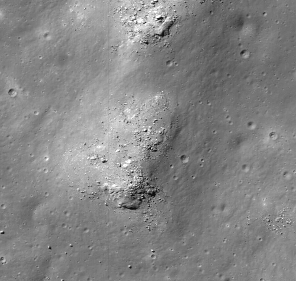
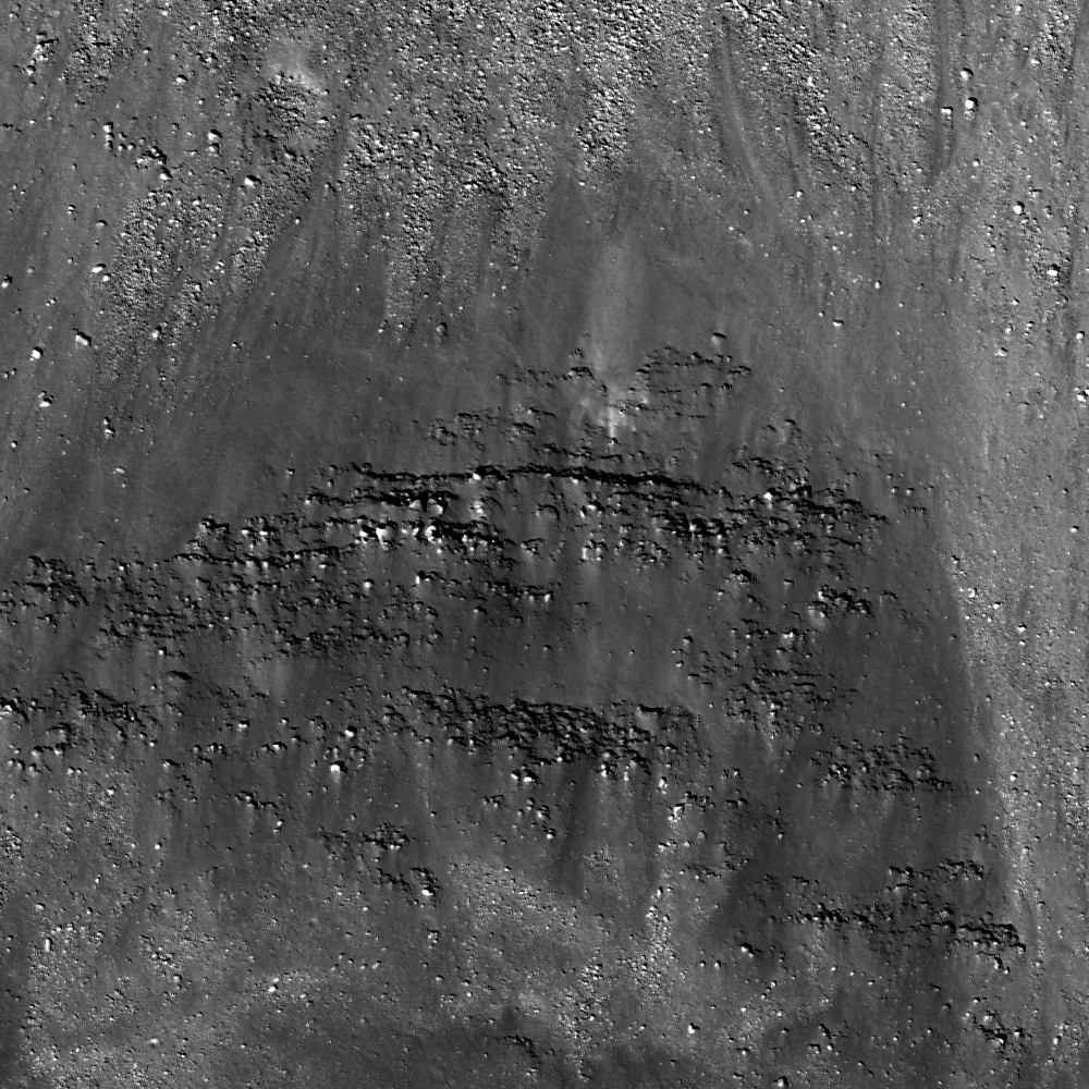
Sunrise, sunset. LROC NAC observations 10 months apart, one at local sunset and the other after local sunrise, both from nearly identical altitudes and resolutions, capture these views of double "dingleberries," drops of hot melt, very likely from the impact that created Vavilov crater, sit where they quickly flattened and cooled, just inside the steep slope of ancient Vavilov D. The Vavilov craters are a study in stratigraphy and superposition [NASA/GSFC/Arizona State University].
Immediately inside the northwest rim of highly degraded Vavilov D, twin disks of impact melt, likely from the formation of Vavilov, came to a standstill at the upper end of a contiguous slope of 5000 meters elevation, over about 40 km, into the complex floor of the latter Eratosthenian crater. This 1400 meter field of view (down slope is to the lower right, centered on 1.14°N, 221.536°E) from LROC NAC observation M1128031686L, LRO orbit 18385, July 9, 2013; 61° incidence angle, resolution 1.17 meters from 114.6 km [NASA/GSFC/Arizona State University]. 
Hiroyuki Sato
LROC News System

Vavilov D is an heavily degraded crater (96.1 km; 0.026°N, 220.93°E) sits between the Orientale basin and Jackson crater, both of which it may pre-date.

The later formation of the nearly identical, over-lapping Vavilov crater (98.2 km; 0.87°S, 221.23°E) eradicated the entire southwestern half of Vavilov D.

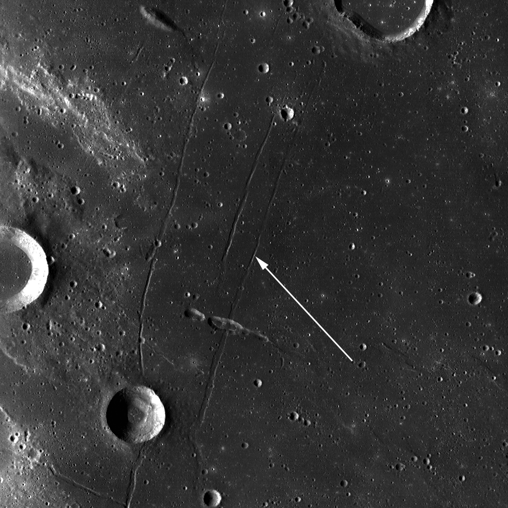
The second image above spotlights a spot on the northwestern curve of the wall of Vavilov D near where the Eratosthenian Vavilov erased the older crater's anatomy. The relatively smooth textured area in the upper left corresponds to the outside of Vavilov D, and the rest of rough/craggy surface is the interior crater wall's steep slope. 

The two degraded craters (~280 m in diameter) near the middle of the opening image exhibit fascinating overlying smooth features that may have formed as material flowed downslope (arrows).

View the full-resolution original HERE. The twin melt disks are located where the rim of Vavilov superseded that of Vavilov D, in the farside equatorial highlands,  where Vavilov is etched into terrain 8000 meters above the global mean elevation. It's possible an astronaut could walk from this location south into the interior of Vavilov. 5.6 km-wide field of view from LROC NAC observation M1128031686L [NASA/GSFC/Arizona State University].
Other morphologic pits/dents on this slope also have similar textures. What we are seeing here are most likely remnant impact melt that was thrown out of the Vavilov crater. Craggy sloped surfaces with patches of smooth material are often found associated with young impact craters -- formed as impact melt flowed over and around the newly formed crater.

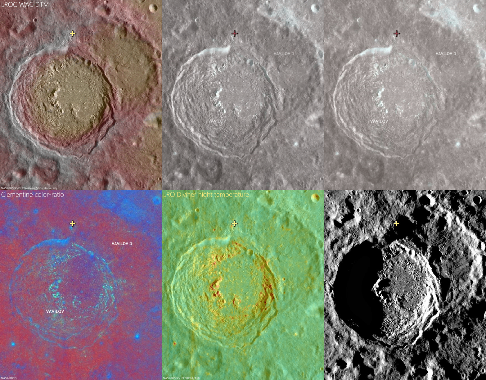
The deepest material brought to the surface by impacts on the Moon is found on the resulting crater's rim. A fresh crater near our area of interest, on the rim of Vavilov D (cross), exposes material excavated by that ancient impact, and Vavilov D, in turn, is nested on the Hertzsprung basin. The larger region is also at the outside range of the majority of secondary craters from the Orientale basin-forming impact. LROC Quickmap mosaic [NASA/GSFC/Arizona State University].
Depth of field in lunar photography is a fleeting quality. With the LROC WAC-derived elevation model (GLD100), however, the super-positioning of Vavilov D (and an aeon or two later, Vavilov) on Hertzsprung is much easier to detect, along with some of the most extreme elevation ranges, some 9 km above the global mean [NASA/GSFC/DLR/Arizona State University].
Related Posts:

Thursday, November 21, 2013

On the chronology of lunar formation and evolution

The Moon about 3 billion years shy of it's most familiar cratering, more or less as it appeared after the basin-forming-impact that created Mare Orientale. From the Goddard / Science Visualization Studio video 'Evolution of the Moon' (2012) [NASA/GSFC/SVS].
A newly published chronology of the Moon's four and a half billion year history, among other things, addresses why certain of its oldest and most familiar nearside basins did not originate from a 'basin-forming-impact.'

Johannes Geiss, Angelo Pio Rossi
The Astronomy & Astrophysics Review   

An origin of the Moon by a Giant Impact is presently the most widely accepted theory of lunar origin. It is consistent with the major lunar observations: its exceptionally large size relative to the host planet, the high angular momentum of the Earth–Moon system, the extreme depletion of volatile elements, and the delayed accretion, quickly followed by the formation of a global crust and mantle.

According to this theory, an impact on Earth of a Mars-sized body set the initial conditions for the formation and evolution of the Moon. The impact produced a protolunar cloud. Fast accretion of the Moon from the dense cloud ensured an effective transformation of gravitational energy into heat and widespread melting. A “Magma Ocean” of global dimensions formed, and upon cooling, an anorthositic crust and a mafic mantle were created by gravitational separation.

Simulation of a Moon-forming impact [Harvard University].
Several 100 million years after lunar accretion, long-lived isotopes of potassium, uranium and thorium had produced enough additional heat for inducing partial melting in the mantle; lava extruded into large basins and solidified as titanium-rich mare basalt. This delayed era of extrusive rock formation began about 3.9 billion years ago and may have lasted nearly 3 billions years.

A relative crater count timescale was established and calibrated by radiometric dating (i.e., dating by use of radioactive decay) of rocks returned from six Apollo landing regions and three Luna landing spots. Fairly well calibrated are the periods from 4 billion to about 3 billion years before present, 800 million years ago to the present. Crater counting and orbital chemistry (derived from remote sensing in spectral domains ranging from gamma and x-rays to the infrared) have identified mare basalt surfaces in Oceanus Procellarum that appear to be nearly as young as 1 billion years.

Samples returned from this area are needed for narrowing the gap of 2 billion years in the calibrated timescale. The lunar timescale is not only used for reconstructing lunar evolution but serves also as a standard for chronologies of the terrestrial planets, including Mars and possibly early Earth.

Head / Brown 2010 crater count
James W. Head of Brown University performed a global census 5,185 lunar craters less than 20 km in diameter (2010). Not surprisingly, a thinner population of such craters are found in and around familiar near side basins, reconfirming conclusions from long ago that the huge plains represent younger surfaces [NASA/GSFC/LOLA/Brown/SVS].
The Moon holds a historic record of Galactic cosmic-ray intensity, solar wind composition and fluxes and composition of solids of any size in the region of the terrestrial planets. Some of this record has been deciphered. Secular mixing of the Sun was constrained by determining the ratio of helium-3 to helium-4 of solar wind helium stored in lunar fines and ancient breccias. For checking the presumed constancy of the impact rate over the past (roughly) 3.1 billion years, samples of the youngest mare basalts would be needed for determining their radiometric ages.

Radiometric dating and stratigraphy has revealed that many of the large basins on the near side of the Moon were created by impacts about 4.1 to 3.8 billion years ago. The apparent clustering of ages called “Late Heavy Bombardment (LHB)” is thought to result from migration of planets several 100 million years after their accretion.

The bombardment, unexpectedly late in solar system history, must have had a devastating effect on the atmosphere, hydrosphere and habitability on Earth during and following this epoch, but direct traces of this bombardment have been eradicated on our planet by plate tectonics. Indirect evidence about the course of bombardment during this epoch on Earth must therefore come from the lunar record, especially from additional data on the terminal phase of the LHB. For this purpose, documented samples are required for measuring precise radiometric ages of the Orientale basin and the Nectaris and/or Fecunditatis basins in order to compare these ages with the time of the earliest traces of life on Earth.

A crater count chronology is presently being built up for planet Mars and its surface features. The chronology is based on the established lunar chronology whereby differences between the impact rates for Moon and Mars are derived from local fluxes and impact energies of projectiles. Direct calibration of the Martian chronology will have to come from radiometric ages and cosmic-ray exposure ages measured in samples returned from the planet.

The full science paper is behind Springer's paywall, HERE.

Related Posts:
Earth and Moon share primal water source (May 10, 2013)
Thin Crust Moon (April 24, 2013)
Making the Moon: Two New Models (October 25, 2012)
Water from the Sun (October 17, 2012)
Hit-and-Run Science, Paul Spudis (September 30, 2012)
A Sawtooth-like timeline for the first billion years of lunar bombardment (August 28, 2012)
A new 'hit and run' Giant Impact scenario (July 28, 2012)
"Our view of the Moon has turned upside down" (April 26, 2012)
Ti paternity test fingers Earth as Moon's parent (March 28, 2012)
NLSI team sheds light on 'late heavy bombardment' (February 28, 2012)
Cataclysmic Conundrum, Paul Spudis (February 14, 2012)
'Significant change' in bombardment timing (January 6, 2012)
LOLA data improves the crater count (September 19, 2010)

Friday, October 4, 2013

Orientalis fall out at Inghirami C?

Boulders scattered across mounds on the floor of Inghirami C may be ejecta nested in melt that originated with the basin-forming-impact that created Mare Orientalis and it's extensive basin 3.1 billion years ago. LROC Narrow Angle Camera (NAC) observation M1114645692L, LRO orbit 16501, February 4, 2013, full 64 cm per pixel resolution crop centered at 44.167°S, 285.309°E. LROC Featured Image field of view roughly 500 meters across, 54.74° angle of incidence [NASA/GSFC/Arizona State University].
H. Meyer
LROC News System

The floor of Inghirami C is littered with boulders that are commonly perched atop closely spaced mounds, some of which are as large as 700 meters by 1000 meters. The presence of these mounds and boulders gives the floor of the crater a lumpy appearance. If simple craters are supposed to be bowl-shaped, where did the material come from to form the mounds? Inghirami C is located southeast of Orientale basin and is adorned with spectacular patterns of ejecta during the basin forming event. Could the lumps and boulders be material from Orientale?

Full 3.2 km-wide field of view of LROC NAC M11144569LE, with the area highlighted at high resolution above outlined in yellow. While amorphous mounds and melt mixtures are common features covering floors of larger craters, like Copernican age Tycho, these features appear more cohesive with no intermediate stages of mixture with their surroundings and mass wasting characteristic of far flung boulders [NASA/GSFC/Arizona State University].
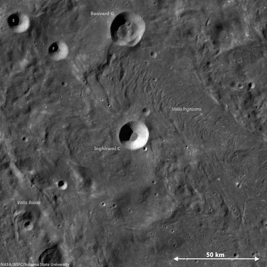
A medium resolution, low illumination angle view of Inghirami C shows the hint of an ejecta blanket from the 19 km crater and its blocky floor, in context with immediate surroundings deeply grooved by forces radiant from the Orientalis basin. Chang'e-2 global photographic [CNSA/CLEP].
In the Wide Angle Camera (WAC) context image (below), the walls of Inghirami C are intact. There are no breaches in the walls to suggest that ejecta from Orientale flowed directly into the crater. If you look closely, you can see a hint of an ejecta blanket outside the rim of Inghirami C. The presence of this ejecta blanket (from Inghirami C) and the lack of breaches suggest that Inghirami C formed on top of the Orientale ejecta.

Inghirami C
LROC GLD100 mosaic showing Inghirami C nested in the midst of a wide area of terrain grooved and infilled by eject from the Orientalis basin-forming-impact. The same influence, radiant from Orientalis, continues far to the southwest and may explain the atypical fill in and around other craters in the Schickard crater group at even greater distances, including Wargentin [NASA/GSFC/Arizona State University].
Using basic stratigraphic principles, this means Inghirami C formed after the Orientale ejecta formed the ridged terrain (seen just outside the rim of Inghirami C in the context image). If the material in the floor didn't come from Orientale or any other large crater nearby, then it must be native to Inghirami C. It turns out that not all simple craters are bowl-shaped with smooth floors -- and in fact many display textured floors covered in combinations of breccias, impact melt, and ejected blocks that can form mounds. Over time, the mounds erode, leaving the boulders seen in today's Featured Image.

Back to the question: Could the lumps and boulders be material from Orientale? Not directly as established above, but perhaps the irregular forms are due to an impact into a chaotic, unconsolidated massive ejecta flow from the Orientale event! The lunar surface is incredibly complex - everywhere you look there is something new, waiting to be explored!

Check out the rest of this exquisite terrain HERE.

Read more about impact excavation:
Excavating Deposits
Polka-dot Ejecta
Off-centered deposits
Forked Impact Melt

Saturday, November 3, 2012

Ocean of Storms, Oceans of Argument

Oceanus Procellarum, the "Ocean of Storms," is easily the largest feature of the Moon's complex topography visible, even to the naked eye, from Earth. But is it a true remnant of a basin-forming impact, merely a low remnant of early lunar morphology or perhaps the largest remnant of a hemisphere-sized impact some have labeled "Gargantua? Thumbnail of a 48-image mosaic captured by Yuri Goryachko, Mikhail Abgarian and Konstantin Morozov (ASTRONOMINSK) of Belarus, August 3, 2010.
Paul D. Spudis
The Once & Future Moon
Smithsonian Air & Space

Once upon a time, back in the Dark ages when I was a young student of lunar science, an idea was advanced that Oceanus Procellarum (the largest dark maria on the near side of the Moon) was the site of an ancient, almost obliterated impact basin.  This “Procellarum basin” (then called the “Gargantuan” basin – superlatives fail us sometimes) has been invoked to explain any and every observed aspect of lunar geology, from the distribution of the dark mare lavas, the near/far side dichotomy, the thickness of the crust, the composition of highland rocks, and the relative amounts of radioactively generated heat flow in the Moon.  Such a useful concept to explain so much!

The acceptance by lunar scientists of a Procellarum basin has waxed and waned over the years.  Originally proposed by Peter Cadogan in 1974, the presence of a large, ancient impact basin covering most of the western near side of this part of the Moon, was advanced to explain the unusually high concentration of the chemical component called KREEP – (K) potassium, (REE) rare earth elements, and (P) phosphorus.  Subsequently, Ewen Whitaker (noted cartographer of the Moon) carefully mapped landforms, such as ridges and massifs (mountains) over this area, which purportedly showed that the patterns were best explained by a three-ring basin – 3200 km across, centered on the western near side.  Whitaker named this feature the “Procellarum basin” after the largest mare region that filled it.  Lunar geologist Don Wilhelms fully embraced this interpretation in his classic book The Geologic History of the Moon, making the Procellarum basin the prime cause for the distribution of geologic units on the Moon.

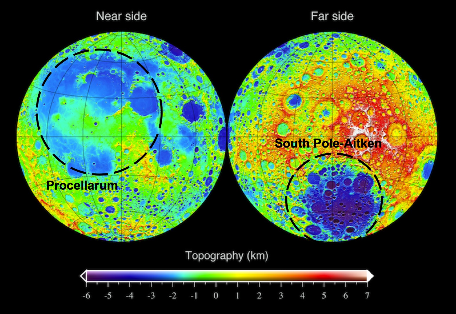
LRO topographic map of the Moon, showing the approximate outline of the "Procellarum" basin on the near side (left) and the South Pole-Aitken basin on the far side (right). One's real, the other isn't.
Yet doubts persisted.  In 1985, Peter Schultz and I suggested that the quasi-concentric arrangements mapped by Whitaker, were related to the Imbrium basin (not to an earlier, underlying mega-basin) on the basis of the ring pattern of this putative feature.  We also pointed out that the patterns of rock compositions supposedly explained by a Procellarum basin were not consistent everywhere, at least casting doubt on the predictive power of the basin’s presence.  The 1994 Clementine mission gave us our first global topographic map of the Moon.  Interestingly, that map dramatically revealed the presence of a circular mega-basin on the far side of the Moon – the enormous 2600 km-diameter South Pole-Aitken basin.  The Procellarum region was also shown to be a low region, but it is not circular (more horseshoe-shaped) and is not as clearly defined as Whitaker’s ring structure suggested.  The stock in the existence of Procellarum basin declined.

But some ideas in lunar science never really go away.  Since that time, several attempts have been made to resurrect the basin.  The latest effort, just published in Nature Geoscience, comes from mineralogical mapping data obtained from the Japanese Kaguya (SELENE) mission.  The authors of this study claim that orthopyroxene (a magnesium-silicate mineral) is distributed on the Moon in association with its largest basins – South Pole-Aitken and Imbrium.  However, in addition to those occurrences, additional outcrops occur in the highlands adjacent to Oceanus Procellarum.  Therefore, these rocks were made during the slow cooling of an enormous impact melt sheet created by the impact which formed the Procellarum basin.

The logic here seems weak.  It has not been established that orthopyroxene only forms from the slow cooling of an impact melt sheet.  When this mineral occurs with the most abundant mineral of the lunar highlands (plagioclase), it makes up a rock type called norite.  Norite is very abundant on the Moon.  It is the dominant rock type at the Apollo 14, 15 and 17 landing sites and occurs elsewhere on the Moon in quantity.  It is particularly prevalent around the edges of the Imbrium basin and one could argue that norite is a characteristic of that basin and the presence of Procellarum basin to explain its occurrence is unnecessary.  Likewise, the existence here of a large differentiated impact melt sheet is inferred from analogy to a terrestrial example, the Sudbury igneous complex, but even in this case, the impact origin of the terrestrial igneous body is not universally accepted.

Evidence for the existence of Procellarum basin must be sought in its topography.  The clarity and preservation of the far side’s South Pole-Aitken basin in the topographic data is surprising.  This feature is one of the oldest on the Moon, yet it preserves relief of over 12 km (the depth one would expect of a fresh feature).  One might expect such an old feature to be indistinct at best, making the discovery of its large relief one of the surprises of the Clementine mission.  At the same time, Procellarum is a vast irregular depression averaging less than 3-4 km deep; its lack of topographic expression is more in line with what one might expect for the oldest basin on the Moon.  However, unlike all other lunar basins, a topographic bulge 2-3 km high occurs near the center of this feature (near the crater Copernicus).  No other basin on the Moon (or on any other planet) contains interior topography higher than the elevation of its topographic rim; at SPA, all of the terrain within the 2600 km diameter rim crest is lower than its rim.  The unusual relation of a bulge within Procellarum does not support the concept that it is an impact basin.  It seems more likely that it is either a feature of internal origin (possibly related to early melting episodes) or a coalescence of several overlapping impact craters and basins.

The elliptical South Pole-Aitken (SPA) basin, mostly on the Moon's farside though it's mountainous outer ring encompasses the the nearside's polar south and the Moon's lowest elevations. The oldest and largest of the Moon's definitively identified impact basins, recent studies appear to have pushed it's formation back beyond 4.1 billion years ago, within less than 500 million years after the formation of Earth and Moon [NASA/GSFC/LOLA].
As we search for the truth, Procellarum basin may well crop up again.  But for today and contrary to the current space press, the new results do not uniquely point to the existence of a large basin here.  In fact, the observations tend to support previous ideas that it is the smaller, overlying Imbrium basin that is associated with a large regional ejecta blanket of roughly noritic composition.

Originally published at his Smithsonian Air & Space blog The Once and Future Moon, Dr. Spudis is a senior staff scientist at the Lunar and Planetary Institute. The opinions expressed are those of the author and are better informed than average.

Tuesday, August 28, 2012

A Sawtooth-like Timeline for the First Billion Years of Lunar Bombardment

A revised timeline of lunar bombardment, featuring greater granularity and matching new assumptions. (Figure 3, Morbidelli, Marchi, Bottke & Kring, 2012) [ arXiv:1208.4624v1 ].
Morbidelli, Marchi, Bottke & Kring
OCA, Nice
Center for Lunar Origin & Evolution, SwRI, Boulder
Center for Lunar Science & Exploration, USRA -
Lunar and Planetary Institute, Houston
TX, USA

We revisit the early evolution of the Moon's bombardment.

Our work combines modeling (based on plausible projectile sources and their dynamical decay rates) with constraints from the lunar crater record, radiometric ages of the youngest lunar basins and the abundance of highly siderophile elements in the lunar crust and mantle. 

The new profile for lunar bombardment
matches a population of 150 basins since
lunar formation
[Frey (2009)].
We deduce that the evolution of the impact flux did not decline exponentially over the first billion years of lunar history, and no prominent and narrow impact spike 3.9 billion years ago, unlike that typically envisioned in the lunar cataclysm scenario. Instead, we show the timeline of the lunar bombardment has a sawtooth-like profile with an uptick in the impact  flux near 4.1 billion years ago. The impact flux at the beginning of this weaker cataclysm was 5-10 times higher than during the immediately preceding period.

The Nectaris basin should have been one of the first basins formed at the sawtooth. We predict the bombardment rate since 4.1 billion years ago declined slowly and adhered relatively close to classic crater chronology models (
Neukum and Ivanov (1994)). Overall we expect the sawtooth event accounted for about 1/4 the total bombardment suffered by the Moon since its formation. Consequently, considering that 12-14 basins formed during the sawtooth event, we expect the net number of basins formed on the Moon was 45-50.

From our expected bombardment timeline, we derived a new and improved lunar chronology suitable for use on Pre-Nectarian surface units. According to this chronology, a significant portion of the oldest lunar cratered terrains have an age of 4.38 - 4.42 billion years. Moreover, the largest lunar basin, South Pole-Aitken, is older than 4.3 billion years and was therefore not produced during the lunar cataclysm.

Friday, January 6, 2012

'Significant change' in bombardment timing

Among the things complicating the definitive dating of the familiar nearside basins is each shows signs of having been resurfaced more than once after their violent formation. Researchers progressed rapidly with secondary and primary crater counting and by retracing contours of topography based on the principle of superposition, that newer craters disrupt the old. Direct sampling allowed further for radio-isotope dating. Now high-resolution photography from LRO is allowing the reading of topography under nearly all lighting conditions. Painstaking analysis in years past has recently been renewed, suggesting a need for revision to the age of Serenitatis basin.
"A Significant change in our view of the impact process, and the history of the Earth-Moon system" is offered by three leading planetary scientists following a pain-staking analysis of LROC images of the eastern side of Mare Serenitatis.

Research by three eminent planetary scientists in the American Geophysical Union's Journal of Geophysical Universe will almost certainly cause a revision in generally accepted lunar timescale and ages for the Moon's most familiar basins. This is so primarily because the authors have had much to do with gathering the original evidence for the accepted dating over the past four decades. Based on high-resolution photography returned by the Lunar Reconnaissance Orbiter Camera their most recent work is filling gaps in tried and true methods for reading the story of the Moon (and the Solar System) engraved on the lunar surface.

The wide-ranging effect of the impact that formed Mare Imbrium has been obvious since the invention of the telescope. Just how widespread has been more difficult to determine. This LROC Wide Angle Camera (WAC) mosaic shows the mixed terrain of the Sulpicius Gallus area within and adjacent to the southwest corner of Mare Serenitatis basin. Radial grooving from Mare Imbrium (not shown), testifies clearly as to the violence unleashed by that basin-forming impact. Until very recently it was thought Serenitatis basin must have formed after the Imbrium event.  [NASA/GSFC.Arizona State University].
LROC WAC monochrome (643nm) observation M119645947ME, LRO orbit 2766, February 1, 2010. Astronauts Gene Cernan and Jack Schmitt explored the Taurus Littrow valley, in the hills southeast of Serenitatis in 1972. The forces that shaped South Massif (SM), North Massif (NM) and the Sculptured Hills (SH) were thought to have originated with the Serenitatis impact event. More recent study of LROC imagery, however, appears to show their near final form resulted from the Imbrium basin-forming impact [NASA/GSFC/Arizona State University].
The Taurus Littrow Valley, explored by Cernan and Schmitt of Apollo 17 (White Arrow, 1972) is a crossroads of lunar morphology immediately adjacent to the Serenitatis basin. Geologist astronaut Harrison "Jack" Schmitt, for example, confirmed his theory that the "Tortilla Flat" ray of material he and Capt. Cernan explored during their second EVA was radial to the 109 million year old "recent" Tycho crater.

At Shorty crater an abundance of orange regolith had been naturally excavated, offering evidence of ancient fire fountains deep in in the Moon's primeval past. Still, snuggled near the shore of Mare Serenitatis, it was far from certain if the Sculptured Hills and other mountains around the valley, indeed whether the valley itself, had been sculpted out originally by the force of the Serenitatis or the more distant Imbrium basin-forming impact.

During their third and final EVA, the last walk the Moon on December 13, 1972, Cernan and Schmitt had the opportunity to sample "Tracy's Rock," or 'Split Rock', a hefty boulder that had, at some point in the relatively recent past, rolled down the south-facing wall of North Massif where it partly broke apart near the valley floor. It offered an opportunity to analyze and sample part of the high mountains imaged almost four decades later from LRO.

Tracy's Rock - the split boulder that brought a significant sample of the Sculptured Hills-type mountains, in this case the North Massif down to the Taurus Littrow valley floor, where geologist astronaut Jack Schmitt and Apollo 17 commander Capt. Gene Cernan could sample it during the last walk on the Moon, December 13, 1972. At top, the same boulder heap is seen in LROC NAC observation M165645700RE, orbit 9545, July 18, 2011; resolution 47.7 cm per pixel from 40.6 kilometers [NASA/GSFC/Arizona State University].
Distinguished planetary geologist Don E. Wilhelms, retired from the U.S. Geological Service, Paul D. Spudis of the Lunar and Planetary Institute and LROC principal investigator Mark Robinson of Arizona State co-wrote the study published in late December. They conclude LRO imagery show the Serenitatis basin is relatively old, not young. 

Additionally, "an old Serenitatis means Apollo 17 impact melts may not date the Serenitatis basin," and either the late bombardment theory was less likely or the Moon's morphology is more poorly understood than is generally believed.

"New images from the Lunar Reconnaissance Orbiter Camera show the distribution and geological relations of the Sculptured Hills, a geological unit widespread in the highlands between the Serenitatis and Crisium basins. The Sculptured Hills shows knobby, undulating, radially textured and plains-like morphologies, and in many places is indistinguishable from the similarly knobby Valles Alpes formation, a facies of ejecta from the Imbrium basin.

"The new LROC image data show the Sculptured Hills in the Taurus highlands is Imbrium ejecta, not directly related to the formation of the Serenitatis basin. This occurrence and the geological relations of this unit suggest the Apollo 17 impact melt samples may not be not samples of the Serenitatis basin-forming impact, leaving their provenance undetermined and origin unexplained. If the Apollo 17 melt rocks are Serenitatis impact melt, then up to half the basin and a large crater population on the Moon was created within 30 million year interval around 3.8 billion years ago, in a global impact “cataclysm.”

"Either interpretation significantly changes our view of the impact process and history of the Earth-Moon system."

Abstract and Text (Subscription), HERE.
The Sculptured Hills of the Taurus Highlands:
Implications for the relative age of Serenitatis,
basin chronologies and the cratering history of the Moon
.
JOURNAL OF GEOPHYSICAL RESEARCH
VOL. 116, E00H03, 9 PP., 2011
doi:10.1029/2011JE003903

Friday, November 18, 2011

LROC: Shiny Mound

Northeastern edge of a high-reflectance mound within "driving distance" of the Apollo 15 landing site on the southeastern frontier of Mare Imbrium. Downslope is to the upper-right. (Field of view 1512 meters across). LROC Narrow Angle Camera (NAC) observation M106869873R, LRO orbit 890, September 6, 2009; resolution 1.26 meters per pixel, incidence angle 36.72° from an altitude of 153.64 kilometers. View the much larger, full size LROC Featured Image HERE [NASA/GSFC/Arizona State University].
Hiroyuki Sato
LROC News System

At the southeastern edge of Mare Imbrium, about 25 km west of Rima Hadley, there is a small shiny mound on a dark and flat mare basalt plain which looks like a white sand island in the middle of a black ocean. This mound is about 2.7 by 2.2 km across. 

Normally fresh slopes and fresh ejecta have high reflectance due to less space weathering but this mound is brightest at its highest elevations and not down the slopes, brighter than nearby ejecta implying the mound is composed of higher-reflectance materials than mare basalts. Then how was this shiny island was formed?

Whole view of high-reflectance mound centered at 25.482°N, 1.684°E (Field of view about 5.3 kilometers. See the original LROC context image HERE, also from LROC NAC frame M106869873R [NASA/GSFC/Arizona State University].
Most likely, the mound is a remnant of highlands sticking through the mare, a hummock of plagioclase-rich highlands materials was embayed by mare basalt volcanism, burying all except its summit. If so, mare basalt is overlapping the mound's skirt. 

Can you see the an overlap contact in today's Featured Image?

An oblique view from a simulated low altitude looking northeast over the LROC WAC 100 m monochrome Global Mosaic affixed to LOLA topography, using NASA's ILIADS program. The bright mound is near the center of the view, with the Hadley Rille Valley and the landing site of Apollo 15 in the background. Does the angle of this view seem familiar? [NASA/GSFC/Arizona State University].
Unfortunately, the contact is not clear or sharp. Over time such sharp contacts are blurred by micrometeorite bombardment. If we are lucky, in the future, a small impact may occur right at the contact once again revealing the sharp contact. Or perhaps a future explorer might take a shovel to this spot and settle the question!

Explore this shiny mound in the full NAC image!

Related posts:
Farside Highlands Volcanism!
Up from the depths
Hortensius Domes - Constellation ROI

Thursday, October 20, 2011

LROC: Lucian's Layers

Layers of material are exposed forming small cliffs just within the south rim of Lucian, perhaps exposing the volcanic strategraphy and geologic history of Mare Tranquillitatis. LROC Narrow Angle Camera (NAC) observation M170321251R, LRO orbit 10234, September 10, 2011; field of view above is 290 meters. View the full resolution field of view in the LROC Featured Image HERE [NASA/GSFC/Arizona State University].
Drew Enns
LROC News System

Lucian crater, located in Mare Tranquillitatis at 14.3°N, 36.7° E, is a small (~7 km in diameter), relatively fresh crater. Because Lucian is still young, rock is freshly exposed in its wall, and the rocks are layered! But how do these layers relate to Mare Tranquillitatis? Scientists think that the maria were formed as the product of large scale flood volcanism.

Billions of years ago large volumes of lava were erupted from fissures in the lunar crust to cover 17% of the Moon's surface. But this process occurred over a period of time with a very low viscosity lava. This model of mare formation predicts that the mare are made up of many distinct layers. Prior to LROC some scientists argued that the layers were thin, and some scientists argued that the layers were thick. LROC data shows Lucian and other craters have thin layers that are a few meters thick. LROC has again helped scientists understand more about the nature of the Moon!

Full width 2 km-wide view of the layering under the surface of the Sea of Tranquility exposed by the explosive impact that formed Lucian crater probably late in the Eratosthenian era (1.1 - 3.1 billion years ago). The flat floor of the crater formed from pooled impact melt is just out of view above, though it is visible in the full NAC frame HERE, and in the Wide Angle Camera (WAC) view immediately below [NASA/GSFC/Arizona State University].

The layering inside the south rim of Lucian, steep slopes and floor of Lucian are visible in a late afternoon local illuminate here in the context of, from north to south, a roughly 36 km long field of view centered on the crater in north central Tranquillitatis: LROC WAC observation (643 nm) M119612004, LRO orbit 2761, January 31, 2010; resolution 61.7 meters per pixel, phase angle 57.81° from 43.76 kilometers [NASA/GSFC/Arizona State University].
A 132 kilometer wide slice of north central Mare Tranquillitatis when the Sun was less than 10 degrees above the east horizon allows more subtle variations in elevation to stand out in long shadows, and with it the variety of ancient features on one the Moon's oldest lunar mare fills. From a monochrome (604 nm) mosaic of LROC WAC observations gathered in sequential orbital passes (orbits 2237 through 2241) December 21, 2009. Highly reduced crop from an original resolution of about 63 meters, at a 57.8° phase angle, from 43.1 kilometers [NASA/GSFC/Arizona State University].
A quick view from the new and improved LROC QuickMap centered on Lucian composed of a base LROC WAC mosaic of northeast Mare Tranquillitatis with the WAC digital terrain model (DTM) overlay (500 meter resolution) at its default opacity of 30 percent [NASA/GSFC/Arizona State University].

How many layers can you count in the full NAC frame?

Related Posts:
Layers near Apollo 15 landing site
Layering in Messier A
Sublunarean void!

Friday, September 16, 2011

It's the Moon's fault


Linear rille in Mare Tranquillitatis, the result of extensional stresses. What caused the offset in the rille on the east wall? LROC Narrow Angle Camera (NAC) observation M146858595LE, LRO orbit 6776, December 13, 2010, field of view 700 meters. See the full size LROC Featured Image HERE [NASA/GSFC/Arizona State University].

Drew Enns
LROC News System

Linear rilles are so named because of their nearly-straight morphology and surface expression. Unlike sinuous rilles, which are volcanic, linear rilles are tectonic in nature. Similar features on Earth are termed graben, and are created when two normal faults border a block of rock which has been depressed, producing a valley.

Since normal faults are understood to be the products of extensional stresses (see yesterday's Featured Image post), we can assume this region of the Moon was "pulled apart" - creating these normal faults, dropping the middle blocks, and producing the linear rilles. So a linear rille is the lunar analog of a graben on Earth!


Full two kilometer width segment of LROC NAC frame M146858595LE, showing the approximate location of the LROC Featured Image, September 15, 2011 [NASA/GSFC/Arizona State University].


LROC Wide Angle Camera (WAC) context images of the Rimae Sosigenes extensional linear rille system in the northeast Mare Tranquillitatis, between the Arago domes (out of view, to the south and east) and the craters Sosigenes and its smaller namesake Sosigenes A. one rille is cross-cut with a close-grouped and prominent secondary crater chain, well-known to well-equipped telescopic observers when the morning terminator passes over five days following a New Moon. WAC monochrome (566 nm) mosaic from orbits 4515-4517, June 18, 2010. See the original LROC WAC context image HERE [NASA/GSFC/Arizona State University].

In today's featured image, two normal faults appear to be offset.

What are we seeing here?


Is Mare Tranquillitatis really an impact basin? Looks can be deceiving, when comparing two familiar and neighboring basins, each flooded multiple times with volcanic flows. Dark and optically-mature regolith covers both Mare Serenitatis (top center) and Tranquillitatis (below - the area of interest is indicated with the yellow area), though the differences in color of each are obvious even in black and white photographs. But In this false-color LOLA elevation map, the nature of Mare Tranquillitatis is less obvious, until one examines more closely and sees how the weight of material infilling the Tranquillitatis plain may have led to finer features like wrinkle ridges and extensional rilles [NASA/GSFC/LOLA/MSFC/LMMP].

It is probably an en echelon step between the two normal faults making up the east wall of the rille. When two faults are near to each other, they can interact and create an en echelon step that helps to even out the displacement and forces that created the faults. En echelon steps are common, and are seen in other tectonic features on the Moon.

Can you find any more faults in the full NAC frame?

Related Posts:
Rima Bürg
Rima Ariadaeus - A Linear Rille

Saturday, August 13, 2011

LOLA: refining impact basin dimensions


Laser altimetry by LOLA, now having traveled nearly 10,000 orbits of the Moon on-board the Lunar Reconnaissance Orbiter, has confirmed the existence of impact basins once believed "questionable" [NASA/GSFC].

GSFC - This image reveals the power LOLA data have in helping scientists refine sizes of impact basins on the Moon. By studying lunar impact basins, scientists refine their understanding of what happened in the earliest stages of the formation of our Solar System, including the size distribution of early impactors.

The Sikorsky-Rittenhouse impact basin, which is estimated to be between 3.9 and 3.5 billion years old, was originally estimated to be 310 km in diameter, and its existence was considered "questionable" in Wilhelms' lunar atlas.


The ghostly Sikorsky-Rittenhouse impact basin, northwest its more-recent doppelganger, the slightly larger and still well-defined Schrodinger basin, is also visible in this LROC Wide-Angle Camera (LROC WAC WMS) global mosaic [NASA/GSFC/Arizona State University].

This initial definition was based on low-resolution images from Lunar Orbiter missions. Later Earth-based radar estimates confirmed Sikorsky-Rittenhouse's status as a basin and placed the basin diameter at 319 km. However, the use of LOLA data have helped scientists to further define the diameter size to 275 km, which represents an 11% decrease in the original diameter estimate. LOLA's high density of measurements across the Moon allows its data to create the most accurate definition of lunar craters ever.

References:
1. Jones, N. and B. Steigerwald, (2010) "NASA's LRO Exposes Moon's Complex, Turbulent Youth," 03 June 2011.
2. Wilhelms, D.E, (1987) The Geologic History of the Moon, USGS Professional Paper 1348
3. Frey, H.V. (2010) Chapter 2, GSA Special Publication Recent Advances and Current Research Issues in Lunar Stratigraphy (in press).
4. Romine, G.C., and H.V. Frey, (2011) "Using LOLA Data to Test the Reality of Candidate Lunar Basins Derived from Older Data," 41st Lunar and Planetary Science Conference, Abstract 1188, March 1-5, The Woodlands, TX.

small | large | high-res [PDF]


Late in its mission, Japan's Kaguya captured this relatively low altitude HDTV view across 98 km-wide Sikorsky (66.1°S, 103.2°E), bisected by 310 km-long Vallis Schrodinger. The northern rim, where the horns of the Valley cross through, is also the broader and essentially invisible rim of the Sikorsky-Rittenhouse impact basin. View the full-sized Kaguya HDTV image HERE [JAXA/NHK/SELENE].

Tuesday, October 12, 2010

LROC WAC: Archimedes


From LROC Wide Angle Camera monochrome (689nm) mosaic of tell-tale Archimedes region, hugging the southeastern edge of the Imbrium impact basin. Even evidence for "emplacement" set forth in studies of 85 km-wide Archimedes (29.7°N, 356°E) was not enough for some early Space Age investigators to accept. Nevertheless, evidence mounted and the sequence generally went something like this: Imbrium impact, Archimedes impact affecting areas in the immediate vicinity, and then the Mare Imbrium mare basalt melt seen today, and embayment of lower elevations [NASA/GSFC/Arizona State University].

Thursday, October 7, 2010

Deep Tranquillitatis basin, south of Cauchy


East central Mare Tranquillitatis, south of Cauchy crater. As one of the oldest near side basins, everything within carries the signatures of subsequent catastrophes. Far beyond Serenitatis, the stresses here radiate from Mare Imbrium. That landmark basin-forming-impact appears to have sloshed melt into Tranquillitatis, like muddy water into a dryer mud puddle. This may be the oldest exposed and deepest mare material on the Moon. That weight may have created the 124 km Rupes Cauchy scarp, partly seen at upper right. Two twelve kilometer volcanic domes, Cauchy Tau (l, near 7.6°N, 36.8°E) and Omega (r) are visible in this field of view seen in LROC Wide Angle Camera monochrome observation M117342496ME during LRO orbit 2412. January 4, 2010 [NASA/GSFC/Arizona State University].

Thursday, September 16, 2010

LRO's LOLA reveals distinct populations in bombardment record and Diviner finds "no pristine lunar mantle," even within SPA


Reduced laser altimetry data from the LOLA instrument on-board the Lunar Reconnaissance Orbiter is presented in this topographic map of Mare Orientale, straddling the western limb and marking the border between the Moon's near and far side hemispheres. New studies using these data show the relatively late, dramatic Orientale "basin-forming impact" may have marked a more definitive change in the history of Earth-Moon bombardment than previously understood [NASA/GSFC/LOLA/Brown University].

LRO project management announced Thursday an investigation using data from the Lunar Reconnaissance Orbiter (LRO) laser altimeter (LOLA) have created the first-ever comprehensive catalog of large craters on the moon. One immediate result is the discovery of distinct periods and populations in the Moon's bombardment record.

Data from the LRO Diviner instrument used in two studies has uncovered a richer complexity to in the anorthosite-rich lunar highlands and, more surprisingly, no evidence of materials composed of the pristine lunar mantle Diviner was partly designed to detect.

The history of the Moon is also the history of Earth.

In a new study, Dr. James Head of Brown University describes results obtained from a detailed global topographic map of the moon created LOLA data.

"Our new LRO LOLA dataset shows the older highland impactor population can be clearly distinguished from a younger population in giant impact basins, inundated with solidified lava flows," Head writes. "The highlands have a greater density of large craters compared to smaller ones, implying that the earlier population of impactors had a proportionally greater number of large fragments than the population that characterizes the more recent lunar history."

The Moon, Mars, and Mercury all bear scars of ancient bombardment, impact craters hundreds or even thousands of kilometers across. Earth must have been subjected to this same assault as well.

Large impacts that occurred long after the advent of life on Earth appear to have resulted in Great Extinctions. The partially buried crater at Chicxulub, in the Yucatan, is from a 65 million years old impact widely believed to have led or contributed to the end of Age of Dinosaurs (and many other lifeforms, as well).

Scientists trying to reconstruct the bombardment history on Earth face difficulties because impact craters are relatively swiftly eroded by wind and water, or destroyed by plate tectonics. A rich record, however, is well-preserved on the Moon. The only source of significant erosion comes from other impacts, small and steady or large and less frequent.

"The moon is a Rosetta Stone for understanding the bombardment history of Earth," said Head. "Like Egypt's Rosetta Stone, the lunar record can be used to translate the hieroglyphics of a poorly preserved impact record on Earth."

Head and his team used the LOLA instrument on-board LRO to build a map highlighting lunar craters with unprecedented clarity.

LOLA sends laser pulses to the lunar surface, measures the interval needed for these pulses to reflect back to the spacecraft and then, with a very precise knowledge of the LRO's orbit, convert these data into increasingly more detailed topographic maps of the Moon, said Head.

Objects hitting the moon can be categorized into distinct populations. Each population has its own characteristics. Head also used LOLA maps to determine the times when these populations changed.

"Using the crater counts from within the basalt-inundated impact basins, the familiar "seas" of the Moon's near side, for example, and examining populations superposed upon older craters, we can date these transitions. The LRO LOLA impact crater database shows a transition occurred about the time of the Orientale impact basin forming event, about 3.8 billion years ago.

"The implication is this change in populations occurred around the same time as the large impact basins stopped forming, and this raises questions of whether or not these factors are related. The answers has implications for the earliest history of the inner solar system, including Earth," said Head.


Map showing locations (in purple) of anorthositic crust exhibiting compositional anomalies. The iron and magnesium-rich maria appear red while calcium-rich highlands appear blue green. The five anomalous silicic features are labeled. Full size figure 11, HERE. (Read the Diviner news release HERE) [Science].

In two other studies, researchers describe how data from the Diviner Lunar Radiometer Experiment instrument (Diviner) on LRO are showing that the geologic processes that forged the lunar surface were complex, also. Data revealed previously unseen compositional differences in the crustal highlands, and these have confirmed a presence of an anomalously silica-rich material in five distinct regions.

Every mineral, and therefore every rock, absorbs and emits energy with a unique spectral signature that can be measured to reveal its identity and formation mechanisms. For the first time LRO's Diviner instrument is providing scientists with global, high-resolution infrared maps of the moon, enabling the definitive identification of silicate minerals in the Moon's crust.

"Diviner is literally viewing the moon in a whole new light," said Benjamin Greenhagen of NASA’s Jet Propulsion Laboratory, and lead author of one of the Diviner papers.

Lunar geology can be roughly broken down into two categories – the anorthositic highlands, rich in calcium and aluminum, and basaltic maria, abundant in iron and magnesium. Both of these crustal rock types are deemed by geologists as 'primitive,' i.e., the direct result of crystallization from lunar mantle material, a partially molten layer beneath the crust.

Diviner observations have confirmed most lunar terrains have spectral signatures consistent with compositions that fall into these two broad categories, but also reveal the lunar highlands are far less homogeneous than previously believed.

In a wide range of terrains, Diviner reveals a presence of fine lunar surface material with compositions more sodium rich than typical anorthosite crust. The widespread nature of these "fines" hint there may have been variations in the chemistry and cooling rate of the "magma ocean" which is now thought to have formed the earliest lunar crust, or these could be the result of a secondary processing of the earliest lunar crust.

Most impressively, in several locations around the moon Diviner detects a presence of highly silicic minerals, like quartz, potassium-rich and sodium-rich feldspar - minerals only associated with highly evolved lithologies, rocks that have undergone extensive molten processing.

Detection of silicic minerals at certain locations is significant because these occur in areas previously shown to exhibit unusually high abundances of the element thorium, yet another proxy for highly evolved lithologies.

"The silicic features we've found on the moon are fundamentally different from the more typical basaltic mare and anorthositic highlands," said Timothy Glotch, assistant professor of geosciences at Stony Brook University in New York, and lead author of a second Diviner Science paper. "The fact that we see this composition in multiple geologic settings suggests that there may have been multiple processes producing these rocks."

Read "New types of rock found on Moon by researchers at Stony Brook," HERE.

No evidence for pristine lunar mantle material


Using data from the Diviner Lunar Radiometer, an instrument uniquely capable of identifying common lunar silicate minerals, scientists at Stony Brook University in New York and NASA’s Jet Propulsion Laboratory have found previously unseen compositional differences in the crustal highlands of the Moon, and have confirmed the presence of anomalously silica-rich material in five distinct regions. Diviner data superimposed on a Lunar Orbiter IV mosaic of Aristarchus crater. Red and orange colors indicate silicic compositions [NASA/GSFC/UCLA/Stony Brook].

One thing not apparent in the data is evidence for pristine lunar mantle material, which previous studies have suggested may be exposed at some places on the lunar surface. Such material, rich in iron and magnesium, would be readily detected by Diviner.

Even in the South Pole Aitken basin (SPA), the largest, oldest, and deepest impact crater yet to be identified on the moon, deep enough to have penetrated through the crust and into the mantle, presented no evidence of pristine mantle material.

It's reported likely if the impact that formed SPA or Apollo basins did excavate any mantle material, it has since mixed with crustal material from later impacts, inside and outside the 2100 km-wide SPA impact.

"The new Diviner data will help in selecting the appropriate landing sites for potential future robotic missions to return samples from SPA. We want to use these samples to date the SPA-forming impact and potentially study the lunar mantle, so it's important to use Diviner data to identify areas with minimal mixing," says Greenhagen.