Showing posts with label Mare Crisium. Show all posts

Wednesday, February 13, 2013

Wrinkle Ridge in Mare Crisium

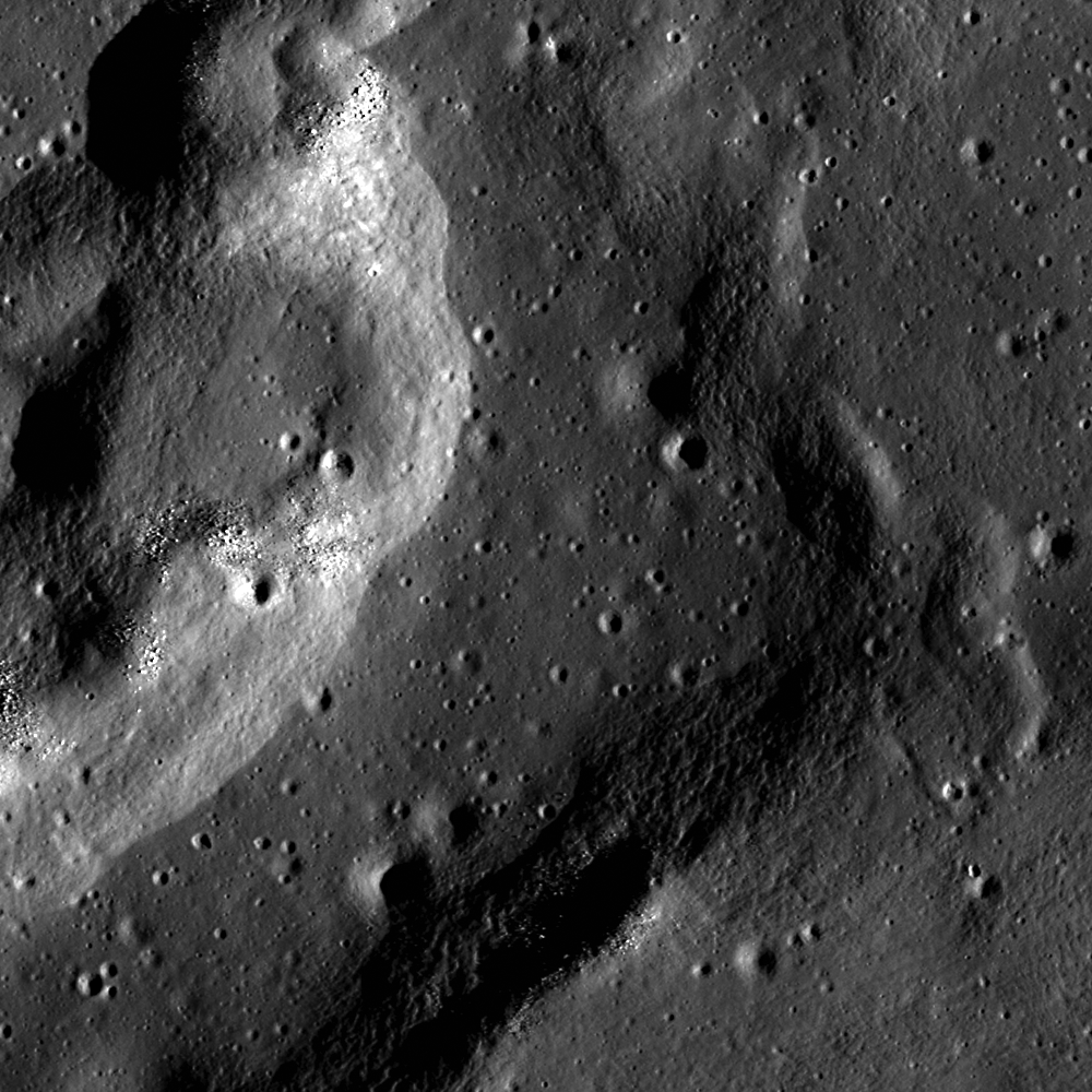
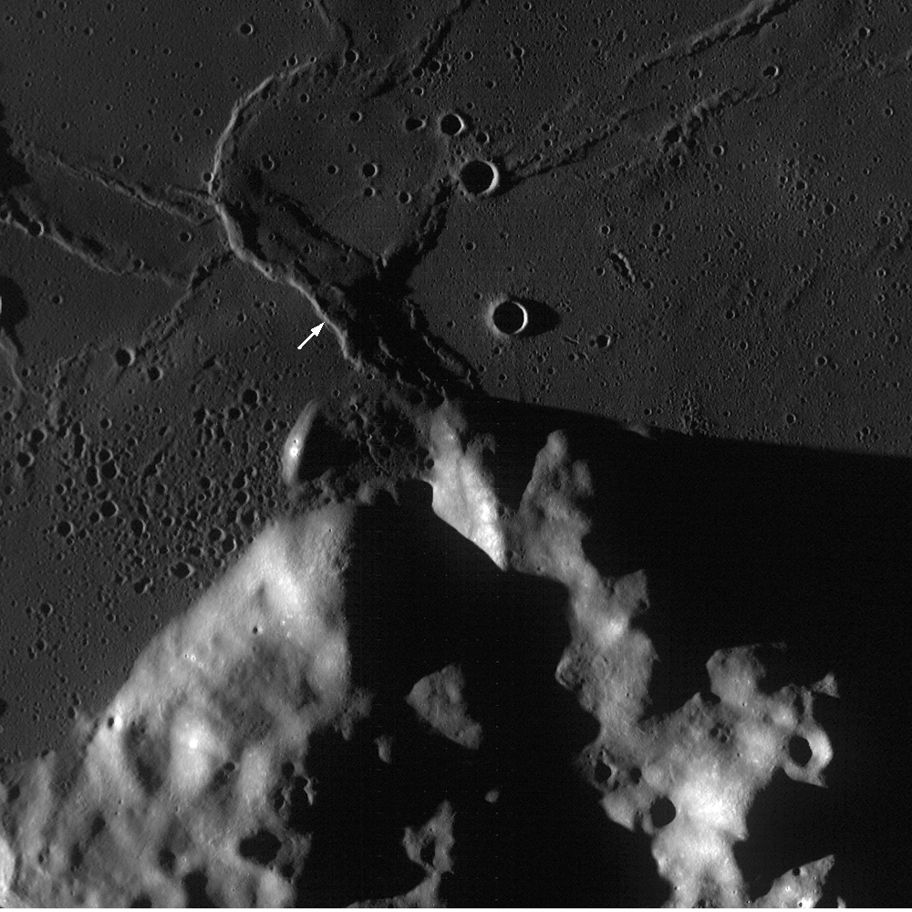
A complex wrinkle ridge in Mare Crisium at low Sun (angle of incidence 72.8° from the east). Boulders occupy the tops of mounds on the west ridge, and the central depression is more heavily cratered than the ridge. LROC Narrow Angle Camera (NAC) M146573730RE, LRO orbit 6734, December 9, 2010; field of view 700 meters at 89 cm resolution from 43.27 km [NASA/GSFC/Arizona State University].
Drew Enns
LROC News System

Wrinkle ridges are complex structural features that tend to develop in contracting regions of the Moon. Unlike lobate scarps (also contractional structural features), wrinkle ridges are thought to result from a mix of folding and faulting.

A buried thrust fault cuts through the mare, but not completely. Instead of breaking the surface, the fault pushes material upwards and causes the mare to fold over the fault.

This folding leads to a wide variety of wrinkle ridge morphologies. Despite this variation, all wrinkle ridges are made up of a larger ridge with a smaller superposed ridge.

A reproduction from the full 2.3 km-wide field of view, including the area at full resolution in the LROC Featured Image released February 13, 2013. LROC NAC M146573730R [NASA/GSFC/Arizona State University].
LROC Wide Angle Camera context image for the LROC Featured Image, highlighting the anatomy of the wrinkle ridge at 16.09°N, 61.68°E. Several other wrinkle ridges are nearby, each with a distinctive form. There are hints also of ghost craters and the kind of volcanic vent structures characteristic of the Marius Hills [NASA/GSFC/Arizona State University].
So when did all of these wrinkle ridges form?

The law of superposition argues that they must be younger than the mare basalt they deform. The basalts in Mare Crisium range in age from 2.5 to 3.3 billion years old!

These dates come from measuring the radioactive isotopic systems of samples returned by the Soviet Luna 24 mission. If these dates are correct and representative of the surface, the wrinkle ridges here formed after the basalts were deposited. Did the ridges start forming after 2.5 billion years? Probably not. Several mare flows also 'pond' behind wrinkle ridges, so the wrinkles must predate at least some mare material and potentially formed over the same time period. One billion years is a long time to go without tectonic deformation after all. One thing is probable, the wrinkle ridges continued developing after mare volcanism shut off in the area.

Explore more of the wrinkle ridge in the full LROC NAC, HERE.

Related Posts:
Bulging Wrinkle
Tectonics in Mare Frigoris
Relative Age Relationships

Tuesday, December 11, 2012

Impact melt in Picard crater

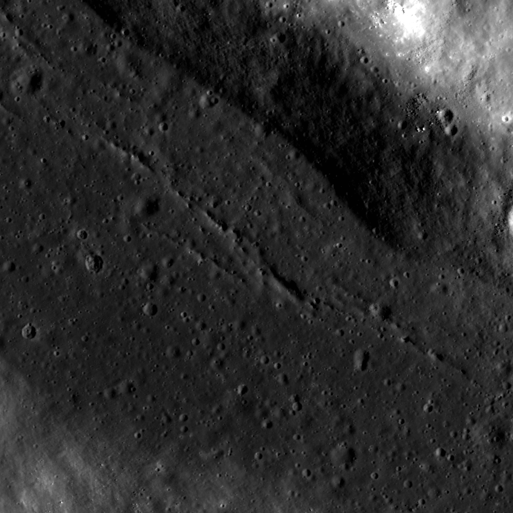
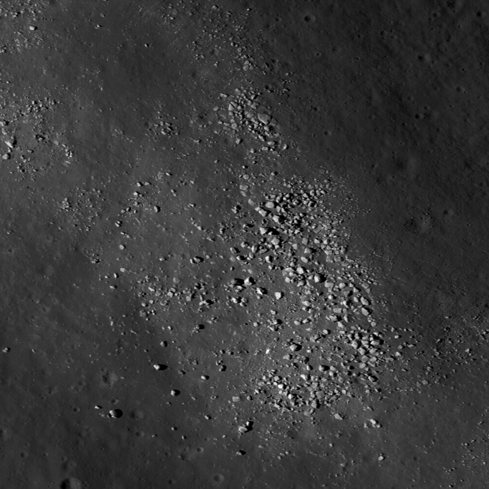
Cracks in ancient impact melt, pooled on a terrace on the wall of Picard, a landmark crater on the basin floor of Mare Crisium. The cracks probably formed during cooling, as the impact melt solidified. LROC Narrow Angle Camera (NAC) M1107917713RE, LRO orbit 15556, November 18, 2012; field of view approximately 1300 meters [NASA/GSFC/Arizona State University].
Drew Enns
LROC News System

Craters inform lunar scientists about many aspects of the Moon's surface and subsurface. Impact craters act as drill holes into the lunar subsurface, excavating deep material and scattering this previously buried material into their ejecta blankets. Impact melt within craters preserves a mix of the material that was excavated as well. Picard crater, at 14.55° N, 54.74° E, exposes a chemically distinct underlying basalt layer in Mare Crisium. In this way, Picard crater contributed to our understanding of the volcanic stratigraphy within the depths of the Mare Crisium basaltic fill. Does Picard crater penetrate through the basalts to expose the underlying highlands material, and can the impact melt help us understand more about the stratigraphy of the Mare Crisium?

Wide contextual view of the interior wall of Picard, from LROC NAC M1107917713R [NASA/GSFC/Arizona State University].
LROC Wide Angle Camera (WAC) context image of 22.34 km-wide Picard. Monochrome (643nm) mosaic of LROC WAC M150158282C and M150165076C (orbit 7264 and 7265, January 20, 2011; resolution 57.3 meters [NASA/GSFC/Arizona State University].

The floor of Picard crater is relatively bright compared to the surrounding basalts (Head et al., 1978) making it likely the deepest material brought up was from benath the mare fill. Thus we can estimate the thickness of the basalt deposit at this location. Spectroscopic studies in the 90's found evidence of both a basaltic and highland rock signature within Picard crater (Blewett et al., 1995). The impact melt that fills a significant portion of Picard crater (like the terrace above) is likely a mix of both rock types, giving Picard crater this mixed signature. Using the LROC WAC Digital Elevation Model (DEM) for the area tells us that Picard crater's floor is about 2300 m below the surface, as is the thickness of the Mare Crisium basalt!

Explore more of Picard crater in the full LROC NAC, HERE.

Saturday, March 17, 2012

The Last Sampler: Failure, then Success

The last direct lunar sample was retrieved by the unmanned Soviet Luna 24 mission, after landing on the northwestern rim of a 64 meter crater on the volcanic plains of southeastern Mare Crisium (12.717°N, 62.222°E), August 18, 1976. Enlargement of lander at lower left (view the LROC Featured Image HERE). LROC Narrow Angle Camera (NAC) observation M174868307L, orbit 10904, during the second recent series of low altitude surveys, November 2, 2011; 43 cm per pixel resolution from 25.57 kilometers altitude [NASA/GSFC/Arizona State University].
Jeff Plescia
LROC News System

Three Soviet missions (Luna 16, Luna 20, and Luna 24) successfully collected and returned pieces of the lunar surface. Before the successful Luna 24 sample return mission in August 1976, Luna 23 was sent two years earlier (November 1974) to nearly the same location in Mare Crisium, but was unsuccessful.

Luna 24 landed in Mare Crisium on 18 August 1976 to complete the unfinished mission of Luna 23. Remarkably, the landing sites of Luna 23 and 24 are only 2.3 kilometers apart.

The region of Mare Crisium where they landed is a typical smooth mare surface with little relief in the immediate vicinity. There are numerous secondary craters scattered across the region, and Luna 24 landed on the edge of one of these. The secondary craters are the result of an impact to the northeast of the landing site, perhaps from the crater Giordano Bruno.

Luna 23 24 regionThe Luna 23 and Luna 24 landing sites. Distance between two landers is 2.3 km. Mosaic of overlapping LROC Nominal Mission NAC frames M119449091L and M119449091R, orbit 2737, January 30, 2010, resolution a half meter per pixel, with the LRO spacecraft slewed 11° at an altitude of 42.91 kilometers  [NASA/GSFC/Arizona State University].
An international mix and match of models made
possible using Google Earth allows this highly
simulated view of Luna 24 today.
Because the precise locations of the various Soviet robotic landing sites were previously unknown to scientists and engineers, finding the spacecraft in LROC NAC images is a high priority. By locating the spacecraft, we gain an understanding of the geologic context of the rock fragments and soils returned by Lunas 16, 20, and 24. Geologic context allows scientists to place the rock fragments and soils into the "bigger picture" within our current understanding of lunar geology, geochemistry, and geologic history. Many of the robotic spacecraft from various nations have been found already in LROC images, but there are a few remaining spacecraft with unknown locations including the early Soviet landers, Luna 9 and 13.

The Luna sample return spacecraft consisted of three flight elements: descent stage, ascent stage, and Earth-return capsule. The entire suite was landed on the surface, and the sample was acquired and placed in the Earth-return capsule. Then, the ascent stage, carrying the Earth-return capsule, was launched to return to Earth. The descent stage of the Luna spacecraft was left on the surface, which is observed in the LROC NAC images of the Luna 16, 20, and 24 landing sites. In the case of Luna 23, the entire spacecraft is still on the surface because it was damaged during landing and was unable to successfully operate and return a regolith sample to Earth.

Stylized rendering of the lift-off of the Luna 24 ascent stage, August 19, 1976. The entire mission took place in the middle of a two-week long lunar night [NPO Lavochkin/RussianSpaceWeb.com/Anatoly Zak].
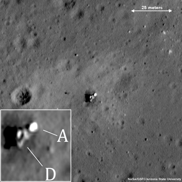
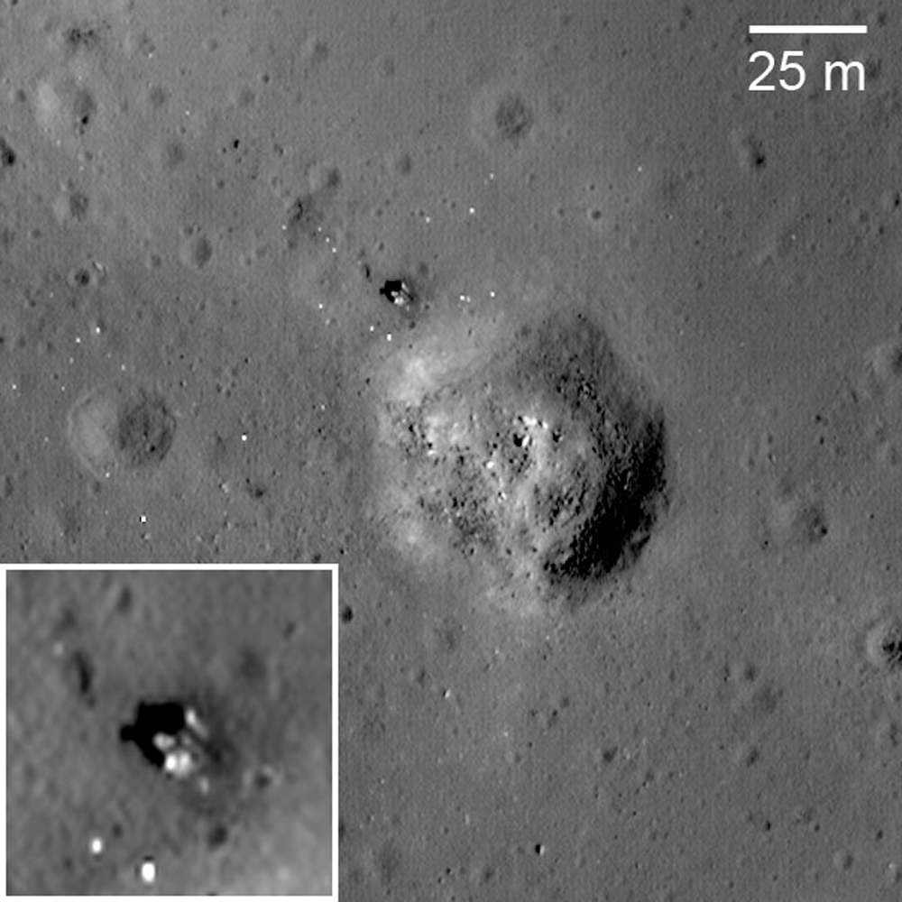
Unfortunately, Luna 23 experienced a malfunction and hit the surface at a very high velocity. Contact was maintained between Earth and the spacecraft after landing, but a sample could not be acquired. At the time, the cause of the failure was not known, but it seemed probable that the whole spacecraft tipped over upon landing at an unexpectedly high velocity. Indeed, the high resolution LROC NAC image (below) shows the spacecraft lying on its side!

The entire Luna 23 vehicle (descent stage, ascent stage and Earth-return capsule) landed at an unexpected speed and fell on its side. Enlargement of vehicle in lower left inset; D: descent stage, A: ascent stage. (Attendant LROC NAC frame M174868307R) [NASA/GSFC/Arizona State University].

Luna 24 landed on Mare Crisium on August 18, 1976. The launch occurred several days earlier, on August 9, from Baikonur Cosmodrome using a four-stage Proton rocket. The vehicle arrived at the Moon on August 13 and spent five days in orbit before descending to the surface. 

After less than 24 hours, the ascent stage fired, sending the sample back toward the Earth. The spacecraft returned a total of 170 grams (0.375 pounds) of regolith to western Siberia, August 22. 

It is hard not to notice all the bright spots around the Luna 24 descent stage. Are they boulders? Most likely, the small (pixel sized) bright dots are pieces of insulation blankets blown off the descent stage when the ascent stage blasted off to send the sample on its way to Earth. If you look closely you can find this type of debris up to a kilometer away from Luna 24! These bright spots are not present around Luna 23 because there was no blast effect from the ascent stage.

The returned Luna 24 sample surprised scientists as it had unexpected characteristics based on the understanding of Mare Crisium geology at the time. Most importantly, the titanium content and the maturity (or the amount of time the sample was exposed to the space environment) of the sample material were different than anticipated. But how could this be? Based on the geologic context of the lander, the reason for the difference may now be understood. With the precise location of the landing site now known, the LROC images show that the mission sampled impact ejecta from a nearby 64-meter diameter crater. That crater has excavated below the surface bringing up material from deeper lava flows that had not been previously exposed to the space environment. Thus, the Luna 24 sample may not represent nearby Mare Crisium surface materials observed using remote sensing techniques, but rather the subsurface which was only exposed to the space environment for the relatively short time. It’s amazing what geologic context can tell you!

Explore the surroundings near the Luna 24 spacecraft, HERE.

Review earlier LROC Featured Images highlighting Luna 16Luna 20 and Luna 24, and the two Soviet rovers Lunokhod 1 and Lunokhod 2.

Monday, July 4, 2011

That Crisium 'ghost crater,' east of Shapley


The Ghost Crater of southern Mare Crisium has been of particular interest to the Lunar Pioneer group for a variety of reasons, mainly because it is situated in the Apollo metric camera digital elevation model and can, therefore, be studied in three dimensions by anyone using the Google Earth application. That's why we were excited when LROC's Drew Enns chose to spotlight a recent LRO Narrow Angle Camera (NAC) cross-section of the formation. The image above shows the 10 kilometer-wide feature swept up in the long shadows prior to local sunset, LROC Wide Angle Camera (WAC) observation M11710778M, from LRO orbit 2392, 42 km overhead, January 2, 2010 [NASA/GSFC/Arizona State University].


A self-defeating miniature of an astoundingly detailed montage of LROC NAC and WAC observations overlaying the Apollo 15 & 17 "J" mission orbital metric camera survey imagery, easily seen when viewing the Moon using Google Earth. During the Apollo science missions, Crisium was under a mid-day sun, to facilitate a landing at Hadley Rille Valley, for Apollo 15, half a hemisphere away. LRO fills in the detail washed out of that bright landscape photographed from orbit in 1971.


A more recent addition to the Crisium Ghost Crater study (LROC NAC observations M150138095R & L, LRO orbit 7260, January 20, 2011), from which the LROC Featured Image release June 23, 2011 was cropped, is a fine late-day close-up of the inundated rim, including calving boulders more than a meter across, and rising 100 meters over the mare-flooded basin's elevation, roughly 3,300 meters below the lunar global mean elevation. The high mountains to the south and completely surrounding the 550 km-wide Crisium impact zone tower over the vicinity, rising quickly up to that global mean in that same lateral distance [NASA/GSFC/Arizona State University].


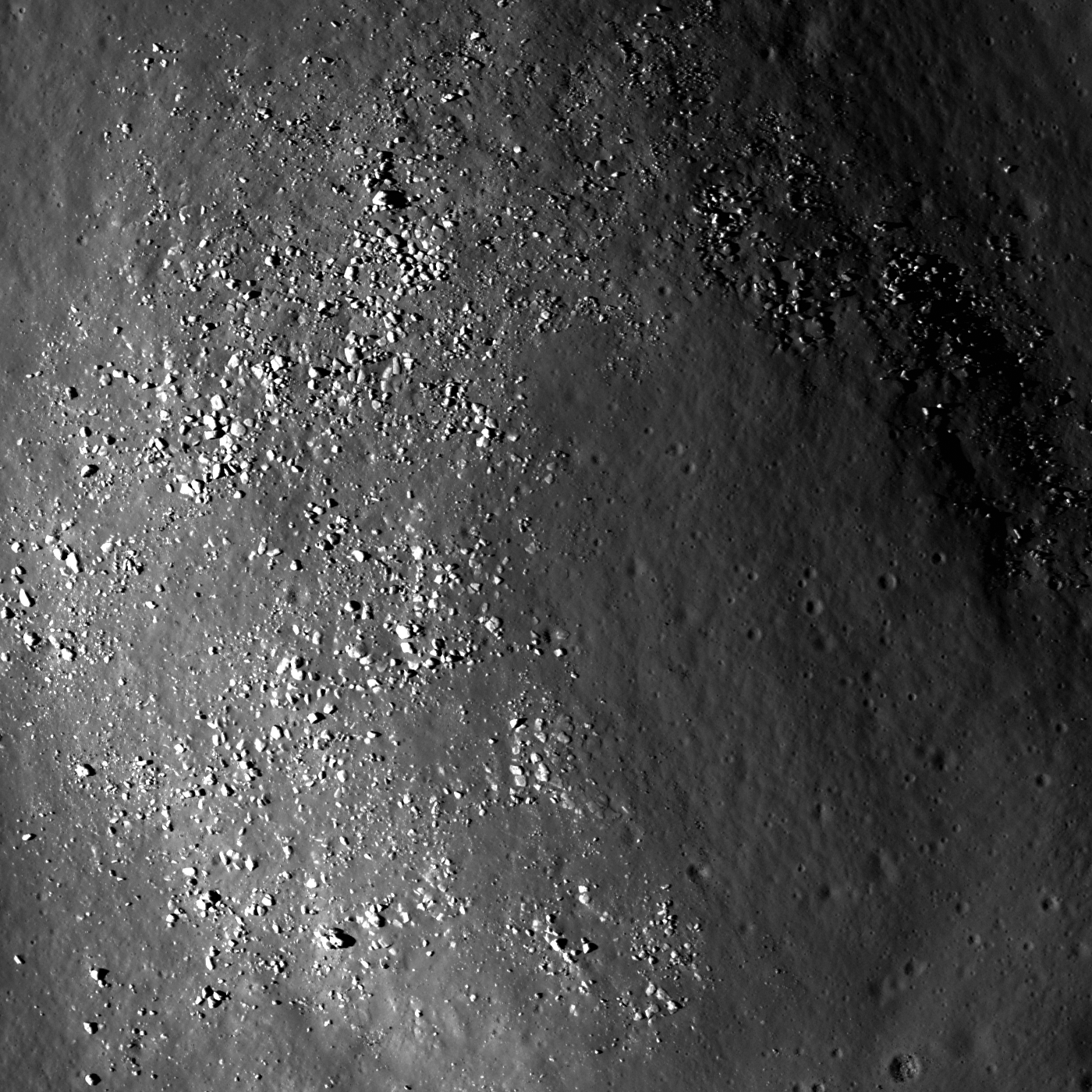
Crest of a wrinkle ridge in Mare Crisium lined with boulders that have most likely weathered out of the summit. LROC NAC M150138095LE, image field of view is 500 meters. See the outstanding full-sized LROC Featured Image, from Ghost Crater in Southern Mare Crisium!, June 23, 2011, HERE [NASA/GSFC/Arizona State University].

Drew Enns
LROC News System

This wrinkle ridge is part of a larger circular network of wrinkle ridges in southern Mare Crisium. Wrinkle ridges are the result of tectonic stresses which have compressed layers of material. On the Moon, these layers are made up of mare lava flows stacked one on top of the other.

When there exists uneven topography, such as a buried (ghost) crater below the lava flows, the lava may deform and produce wrinkle ridges. Deformation occurs preferentially over the buried crater rim, and a circular wrinkle ridge is formed, hinting at the ghost crater beneath.

From Lunar Pioneer Album 5 -
Context image of the ghost crater within Mare Crisium (located at 11.1°N, 59.7° E). The LROC Featured Image, june 23, 2011, is located at the tip of the white arrow. From the LROC WAC 100 m global mosaic, field of view 20 kilometers [NASA/GSFC/Arizona State University].

Ghost craters are valuable scientific tools as they can provide minimum thicknesses of mare units. Knowing the diameter of a crater can quickly yield the depth of the crater, thanks to observations and tests performed by scientists. If we know the diameter of the ghost crater, we can estimate the minimum thickness of a given mare unit! This ghost crater is 16 km and using Pike's equations the crater depth should be 1.7-2.4 km.

Explore the wrinkle ridge further in the full NAC frame!

Related Posts:
Lava Flows Exposed in Bessel Crater
Sublunarean void!
Wrinkle ridge in Oceanus Procellarum


Looking south from the surface of the inundated crater rim, in a virtual environment, the high Crisium basin rim can be seen, more than three kilometers over the basin's interior, and another two thousand meters above the original basin floor, below the deep basaltic lava floods nearly covered it completely, nearly 4 billion years ago.

Monday, July 5, 2010

LOLA's Sea of Crises


NASA GSFC - Located in the northeast quadrant of the lunar near side, Mare Crisium is a Nectarian aged basin that spans 740 km. LOLA data reveal that the floor of Mare Crisium is approximately 1.8 km below lunar datum, or "sea level," the Moon's global average elevation - while the outer rim is about 3.34 km above lunar datum.

Lava flow features are prominent enough in this mare that they can be seen in the LOLA topographic data (see arrows in image for locations of some of these features).

Two Soviet missions landed in Mare Crisium in the 1960's and 70's. Luna 24 landed in Mare Crisium in 1976 and returned samples from the lunar surface to Earth.


Brighter shades represent higher elevations in this early release of LOLA data showing the outer rings of the ancient impact. Palus Somni and the rays of Proclus on the basin's western extremes, so familiar to observers on Earth, are not so distinct in this digital elevation model [NASA/GSFC/MIT].

Luna 24's predecessor, Luna 15, was less successful. It crash-landed in Mare Crisium in 1969.

Mare Crisium is also the location of Luna City - a fictional city featured in the book "The Moon is a Harsh Mistress."

View the LRO/LOLA Crisium Image of the Week, July 2, 2010:
+ View Image | + High Resolution


All or parts of eleven LROC wide-angle camera surveys and at least as many narrow-angle camera frames, contribute to this montage-in-progress centered on the Constellation Region of Interest at the confluence of wrinkle ridges near Dorsum Termier. The southern half of Mare Crisium is shown in stark relief. A wallpaper-sized image is available HERE [NASA/GSFC/Arizona State University/Google Earth].

Thursday, July 1, 2010

LROC PDS Release 2


A better view of the Constellation Region of Interest at Mare Crisium (10.8°N, 58.6°E), improved by the additional release to the Planetary Data System (PDS) of Lunar Reconnaissance Orbiter Camera (LROC) imagery through March 15, 2010. Stretching toward the southeast the prominent Dorsum Termier wrinkle ridge steadily (and very, very slowly) sheds boulders originally pushed up by the migration of unevenly cooled sheets of volcanic melt. The LROC spotlight was on the field of view at center foreground when a portion of LROC NAC M119469420LE was the LROC Featured Image, March 11, 2010. The Right-hand frame from that same session (M119469420RE), swept up January 30, 2010 (LRO orbit 2740), doubles that field along the original image east boundary. The texture of mountains in the distance, the inner ring along the southern edge of Crisium basin, is made possible with the addition of LROC Narrow-Angle Camera and Wide-Angle Camera images gathered under varying degrees of illumination. Full size view (1920 x 1110), HERE [NASA/GSFC/Arizona State University].

Mark Robinson
Principal Investigator
Lunar Reconnaissance Orbiter Camera

LROC News System

The LROC team released images acquired from January 1, 2010 through March 15, 2010. This release contains 51,070 LROC EDR products, which has a total volume of 6 TBytes and 50,972 CDR products totaling 11 TBytes.

For this release the NAC-R was mirrored (left-to-right) to match the orientation of the NAC-L (newly released data as well as all of the NAC-Rs of the prior release). This change was implemented for user convenience. Additionally the index file was modified for each product (EDR and CDR) adding new fields to aid in understanding NAC image orientation. A full description of the NAC-R to NAC-L orientation has been added to appendix (C) of the LROC SIS.

The second LROC PDS release, totaling 17 TBytes of data, is now posted on NASA’s Planetary Data System. Images are available from the LROC image gallery.

Friday, March 12, 2010

LROC: Crisium Constellation ROI

Updated March 12, 2009, 1530 UT
Rocky boulders on a wrinkle ridge contiguous to Dorsum Termier, within south-southwestern Mare Crisium, may help us understand the rich morphology of this Constellation region of interest. The scene depicted above is 184 meters from the 460 meter field Featured Image headlined by the Lunar Reconnaissance Orbiter Camera (LROC) News System, March 11, 2010 [NASA/GSFC/Arizona State University].

Brett Denevi
LROC News System

The Constellation program region of interest located in Mare Crisium is a compelling Exploration site for many reasons. First, this site was visited by several Soviet landers - Luna 23 and Luna 24 both touched down in Crisium. Luna 24 succeeded in returning a 170 gram sample in 1976. Though the amount was small, it provided a wealth of information and an interesting mystery. The Luna 24 basalt has a titanium dioxide content of about 1%, placing it among the lowest abundances of any lunar basalt sampled. The titanium content of basalts on the Moon varies widely, from almost none up to nearly 15%; a much wider range than typically seen on Earth. Because samples were only returned from a few limited locations on the Moon, we use remote sensing data to fill in the gaps of our knowledge (read this PSRD article for more details).

Basalts that are rich in titanium absorb more light in ultraviolet and visible wavelengths than those with less titanium, and many people have used this relationship to estimate titanium contents for mare basalts across the Moon. However, in the case of Mare Crisium, the remote sensing estimates put the titanium abundance at two to four times higher than what is seen in the Luna 24 samples. Plus, the way the light is reflected from the samples (the reflectance spectrum) looks different from what spacecraft observe for Mare Crisium. Other landing sites for which we have samples and that we have observed with spacecraft do not show this difference. So what is happening in Mare Crisium, and why should we care?


Lunar Pioneer was late posting the latest Featured Image released by Arizona State's LROC team on Thursday, March 11. We were stunned with an embarrassment of riches. The wide-angle camera context for a truly remarkable narrow-angle (49 cm pp resolution) image release happened to be of an area about which we have a strong interest. Coincidentally, the area happens also to be one among 50 Constellation Regions of Interest (ROI's), in the southwestern Crisium basin. So we took more time to boot up both images together in the lunar map available to users of Google Earth. Additionally, the ROI and LROC Featured Images are also within the eastern extreme of the highest resolution topography of the Apollo orbital corridor Digital Elevation Model. We have a lot more to say about this area shortly, including an expression of our heart-felt appreciation for the recent addition of a newer Moon-wide higher resolution DEM beyond the confines just of the corridor. For the present, a taste of these LROC images are presented here in three dimensions.

As you can see, within minutes after a LROC image availability, it is now possible to quickly present something not unlike what a future crew might see out the port-side view after landing at the SW Crisium Constellation ROI landing site, flawed though it may be in terms of overall illumination.

Scientists love a good mystery, but it's also important because titanium is both a valuable resource that could be utilized when people return to the Moon, and titanium abundances can tell us about the lunar interior. Basalts formed by partially melting the lunar mantle billions of years ago, and the wide range in titanium contents can tell us about the wide range of compositions and processes in the lunar mantle. Most of the high titanium basalts appear to be concentrated on the lunar nearside. But why? A straightforward interpretation of the lunar magma ocean theory, where the Moon was partially or completely molten just after its formation, suggests that titanium should be globally distributed, but that's clearly not the case. Human exploration of this region will produce valuable sampling and fieldwork to address this question.

The geology of this site is also compelling. The Constellation site is located near the rim of the Crisium impact basin (see image below), and samples and field work would give insight into the processes that occurred during the formation of the basin, as well as the age of the basin. Was this impact basin part of the so-called lunar cataclysm? This site also contains beautiful wrinkle ridges, sites of compressive stresses that resulted in faulting and wrinkling of the mare basalt surface. In the image below, you can even see a wrinkle-ridge ring, where a buried crater localized the stresses.


LROC Wide-Angle Camera (WAC) monochrome image centered on the Crisium Constellation region of interest (ROI). The highlands area in the south is the rim of the Crisium impact basin (nearly four kilometers in elevation above the "sea floor" below) and wrinkle ridges and the rim of one of at least three nearly submerged craters in the vicinity is apparent. The arrow points to the location of the center of the Narrow Angle Camera Featured Image and the WAC field is 62 km across [LROC WAC M117107778ME - NASA/GSFC/Arizona State University].

In the WAC monochrome image above, the arrow indicates the location of the NAC frame at the beginning of this post, which shows a very small portion of a wrinkle ridge. A fascinating feature of this ridge, when seen in high resolution, is a surface strewn with boulders. Perhaps these were generated by the breakup of the mare basalt, visible now because of the faulting and folding that created this ridge. (Judge for yourself exploring the full-resolution NAC frame here.)

Lunar scientists (not engineers) love boulders because they usually come from below the surficial regolith layer and can indicate buried rock units of different compositions. Some have suggested Luna 24 sampled a basalt unit that was buried by a subsequent lava flow of a different composition and only exposed where impact craters excavated material from a depth. This scenario would explain why spacecraft don't see the sampled material widespread on the surface. Visiting the Crisium region of interest could help scientists unravel this interesting puzzle.

Below: A very small part of the original LROC NAC image (M119468420LE) - 460 meter-square field reduced from the original here as context for the first image at the top of this post, and yet another demonstration of how scale can be a very difficult thing to grasp in lunar photography. In the Second Image from the TOP, the same area below is shown as the slightly darker gray square at bottom center, rendering the 460 meter field from a slightly different perspective and within the whole NAC frame strip from which it was taken - and subsequently within the larger WAC image release discussed her - all reproduced in Google Earth. (Click on image below for the 1000 pixel original).


Below: In Google Earth, looking west, the whole of the ROI can be seen, though admittedly very poorly constrained to this 400 pixel-wide column. The scene below is also an unfortunate confusion of solar illuminations, with the LROC WAC image of the Region Of Interest highlighted by long evening shadow and the Apollo 15 metric imagery below and beyond when the area was under a late morning sun in late July 1971. Additionally, the very dark band of the LROC NAC Featured Image (visible in lighter gray in the Second image from TOP) traces out LRO polar orbit (#2740) of January 30, 2010.

Wednesday, October 7, 2009

GoogleMoon, Limited (Part Two)


The Big Tease: Two high-resolution samples of the lunar surface in GoogleMoon™ represent interesting and widely varied near side terrain thought by too many as adequately understood. Exploring these areas in the program can seem like a child's first look at pond water under a microscope. Though you won't see anything swimming around, you can go for a swim in the data.

Joel Raupe
Lunar Pioneer

The largest of two high-resolution strips in GoogleMoon combines orbital metric photography from Apollo with laser altimeter data and Terrain Camera images from Japan's Kaguya and India's Chandrayaan-1 in a six degree-wide swath through ninety degrees of longitude - a quarter way around the Moon - from 25.2°N, 331.8°E (28.2°W) in Mare Imbrium on the West to 7.8°N, 60.8°E, near Lacus Persevertantiae southeast of Mare Crisium, on the East.

A smaller 160 kilometer-square part of the Southern Lunar Highlands surrounds the Apollo 16 landing site and includes the distinctive topography of the Descartes Formation and its albedo Swirl. Finally, in GoogleMoon™ are small swaths from early Lunar Reconnaissance Orbiter (LRO) imagery of each of the six Apollo landing sites.

High-resolution laser altimetry is not weaved into these LRO images of the landing sites of either Apollo 12 or Apollo 14, making those areas unsatisfactory and two-dimensional, like the largest part of the lunar globe disappointingly represented by Clementine (1994) baseline imagery with much far lower resolution altimetry, on the whole creating a wide-rolling flat worldwide enlarged and highly pixilated photograph.

The Apollo Metric Cameras were deployed from the Service Modules of Apollo 15, 16 & 17, Apollo's science (or "J") missions. These film canisters were retrieved in deep-space EVAs during the long coast back to Earth, after leaving lunar orbit.

GoogleMoon™ does not include the full range of this Apollo photography, particularly of the far side. While confined to the sun-lit surface under orbits keeping Command Modules over the landing sites, the full range of the surface photographed from orbit covered at least ten-fold more of the surface.

Kaguya and Chandrayaan-1 altimetry, if not their terrain cameras, covered the entire Moon.

Hopefully GoogleMoon™ developers await data gathered by LRO and a future roll-out of GoogleEarth™ (v.6) for a more complete coverage of the rest of Moon. Putting together what they have must have been a lot of work.

The high-resolution that is available in GoogleMoon™ is represents thousands of square kilometers of detail in context, allowing a human perspective of what would otherwise simply be a flat-file of numbers.

Devoted lunatics are now allowed an opportunity to "see it like a native," and to classify some newly-resolved features invisible using the best telescopes on Earth.


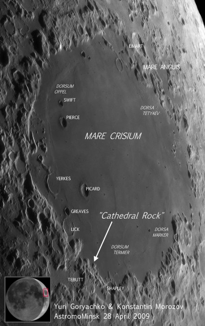
'Cathedral Rock,' a collis, a "hill or knob" according the USGS Gazetteer of Planetary Nomenclature, and a word used to distinguish a feature not generally associated with the Moon. From laser altimetry and topography from Japan's Kaguya, dovetailed into Apollo photography, it now appears certain families of colles may become as readily associated with the Moon as are other features with familiar Latin names, like "lacus" for lake or "dorsa" for wrinkle ridges.

This is the largest example of what evidence indicates is a common feature in certain locations on the Moon.

The collis 'Cathedral Rock' is apparently one in a family, sharing distinctive characteristics. In the picture immediately above, like Medieval siege engines rolled to the edge of a city wall, 'Cathedral' stands not far from two smaller family members, off in the distance. The view is from a perspective slightly above the basin floor aimed to the southeast, along a small part of the massive Crisium rim.

We're very unofficially calling this family of colles the "colles arduum," because of the arduous work needed to get to their top. These seem to be a common sight where the basin's lava-flooded interior basin butts up against its inner ring. Crisium formed through a cataclysmic impact 3.92 billion years ago, but aside from globe-shaking moonquakes that have occurred throughout that long period, bringing material down in repeated slumps from the heights beyond, this family of colles have looked much as they do today during all that time.

On Earth such formations would immediately be guessed to be the result of wind and water erosion but these colles are made of some pretty tough stuff, perhaps at its hardest along the length of its spire.

These features are dark, when found in the Apollo images, as well, indicating a very long period of optical maturity and at least 900 million years of exposure to the sun.

Perhaps the colles are fumaroles, formally within the crust that was blown away from the center of the Crisium impact 200 kilometers away. We note that the colles seem common along this basin wall but we have also found similar collis deep within basin's interiors.

The base of collis "Cathedral Rock" (10.81°N, 54.32°E) is around a kilometer across and irregularly shaped. Like other members of its family there is also is is a secondary ridge on top of this, running length-wise. And from the end of the secondary ridge that is furthest away from the Crisium ring behind it is the landmark spire rising almost to a point.

The inner ring of mountains surrounding Crisium seen behind the tower rises another kilometer and a half above the basin to the left, itself around 3,500 meters below the Moon's mean elevation. The top of the Cathedral's spire is 1,500 meters above the basin. Further along to the east-southeast the basin's steep wall reaches above 500 meters, adding up to a difference in elevation of at least a 4 kilometers within a two to three kilometers walk.

And this is pretty average and not record-breaking for the Moon or Crisium.


'The Boys from Minsk' - That's what Charles A. Wood, proprietor of the Lunar Picture of the Day (LPOD) web repository casually calls the astrophotographers publishing some breathtaking, painstakingly-created and state-of-the-art lunar photography work using the name Astromominsk. It would be unfair to say their work is 'the best' but it easily ranks in the top ten on Earth. These days professional astronomers largely confine their time on the Great Telescopes to stars and galaxies. Institutional telescopes are almost too sensitive for the relatively brilliant objects in the neighborhood, especially the large and "familiar" near side of the Moon. Meanwhile people like Yuri Goryachko & Konstanin Morozov, along with a small number of others throughout the world, are using modern instruments and CCDs to image regions of the Moon in high-definition and then assemble these into astounding mosaics, creating the the best images of the Moon available from Earth. There may not be a single "best" image of Crisium by there individuals and small teams. Like everywhere else on the Moon Crisium reveals its secrets under favorable lighting, almost always when the phase of Sun, Moon and Earth, along with lunar libration, cast sunlight on the landscape in sharp relief, bringing into view some features dwarfed by their shadow, at no other time during lunar orbit.

We decided to verify Cathedral Rock because we wanted to investigate the usefulness of GoogleMoon, as a legitimate tool of exploration.

In a preliminary search through the best lunar photography taken from Earth we began with the many excellent images of Crisium contributed by scientist-artists to Charles A. Wood's Lunar Picture of the Day.

In the end we chose a mosaic referenced there and composed from 9 images of a Crescent Moon last April, assembled by Yuri Goryachko & Konstanin Morozov.

The image immediately above was ripped from that mosaic.

The tip of the arrow designates an apparently empty spot near a tiny peninsula, meandering north (top) 15 kilometers or so into Crisium from its surrounding inner ring. It is the precise spot where we found Cathedral, and the face of the range immediately behind it in the second image from the top of this article is part of the small peninsula above. It looks very small 400,000 kilometers away, but the tip of the arrow points at what looks like more basin floor.

At this point we decided to pause to ask ourselves one very simple question.

Is it real?

Mons Hadley Delta (Kaguya Terrain Camera TC-008). Instead of trying to prove Scott and Irwin of Apollo 15 really explored the edge of Hadley Rille in 1971, scientists at JAXA used the Kaguya Terrain Camera to generate the perspective seen on the left and compared it with AS15-82-11122HR, a photograph taken from the location during Apollo 15's first EVA, July 31, 1971. (The Kaguya Terrain Camera image was released June 13, 2008) When compared in full, the high-resolution compilation in GoogleMoon™ is better, even without the strip of LRO narrow-angle camera covering a lot of the same terrain. What is missing, even from LRO imagery of the region, is granularity. LRO's resolution from its present 53 km orbit eight tenths of a meter per pixel. [Kaguya Image Gallery, NASA/JAXA/SELENE]

It's important to know if Cathedral Rock is really there.

If it is a powerful tool for lunar exploration has been made available to a very large group of devotees.

GoogleMoon™ can't be a substitute for other tools of exploration and analysis, but it may present a powerful answer to a problem recently posed by Apollo veteran and geologist Dr. Harrison H. "Jack" Schmitt. He has noted a big problem presents itself in the sheer size of the data collected by a the small, but very sophisticated fleet of 21st century probes; China's Chang'e-1, Japan's Kaguya, India's Chandrayaan-1 and the Lunar Reconnaissance Orbiter from the United States. The depth of these data presents scientists with a formidable analytic and cataloging nightmare.

Ten years after Lunar Prospector de-orbited into Shoemaker Crater, near the lunar south pole, scientists still work and tweak data that the $60 million orbiter returned, and they are still discovering new things. Chandrayaan and Kaguya returned datasets that dwarf what was returned from earlier missions, and nearly as much information has already been returned from LRO after barely more than 110 days into its mission.

Is one solution to the problem of slow assimilation and analysis of these data standing right in front of our eyes?

Years into the Age of Video Games, with virtual worlds made three-dimensional with ray-trace animation, it's prudent to examine whether a feature like Cathedral Rock is just repeated landscape, like virtual trees repeated over and over in a Flight Simulator landscapes, patterns within an otherwise realistic landscapes that are just 'filler.' There are other families of colles that share strikingly suspicious similarities elsewhere in the high-resolution corridor in GoogleMoon™, and we will discuss these in Part 3.


HTML clipboardUnlike the deceptively smooth basin floor imaged from Earth, this photograph from the Metric Camera on-board Apollo 17, looking almost in the opposite direction, shows Crisium's floor to be a very tortured place. Greatly enlarged from the image available at Arizona State University, but still nearly invisible without considerable adjustments, something is definitely seen where GoogleMoonclaims it to be [Lunar Pioneer/GSFC/LPI/ASU].

Thursday, September 24, 2009

The why and where of water on the Moon

Arlin P.S. Crotts
Department of Astronomy, Columbia University
Columbia Astrophysics Laboratory,
Informal to the Lunar-L Group
I am not sure why so few investigators have paid attention to these results, but if you would like to see an analysis of the situation regarding lunar water that takes these and the rest of the evidence into fair consideration, please refer to my paper (originally submitted June 2007, resubmitted September 2, 2009)

"Lunar Outgassing, Transient Phenomena & the Return to the Moon II: Predictions and Tests for Outgassing/Regolith Interactions," Crotts & Hummels (2009), Astrophysical Journal, submitted http://lanl.arxiv.org/abs/0909.3832

If you look at the current evidence, it indicates that the water content is higher at greater depths, and may not be fundamentally a surface effect. (Please refer to the Akhmanova et al. 1978 paper: "Water in the regolith of Mare Crisium Luna-24," Akhmanova, Dement'yev & Markov (1978) Geokhimiya, 2, 285).

IR diffuse reflection and IR transmission studies of lunar soil samples obtained by Luna-24 are described. Approximately 0.1 wt% water was detected in samples from a depth of 143 cm, and the amount of water seemed to increase with depth, although the extent of change was almost at the limit of technique sensitivity. The possibility of sample contamination by water is considered.

Water was not detected in samples obtained during earlier moon missions when a similar procedure was applied, but in the earlier studies the lower limit of detection was approximately 0.2 wt% water. The significance of the detection of water for theories of lunar development is indicated.

There are a number of ways to approach this problem, and I have papers coming out based on further data, but I will not tip my hand about these at this time.