Showing posts with label Soviet Union. Show all posts

Monday, September 17, 2012

Close-up on the lonely trail of Lunokhod-2

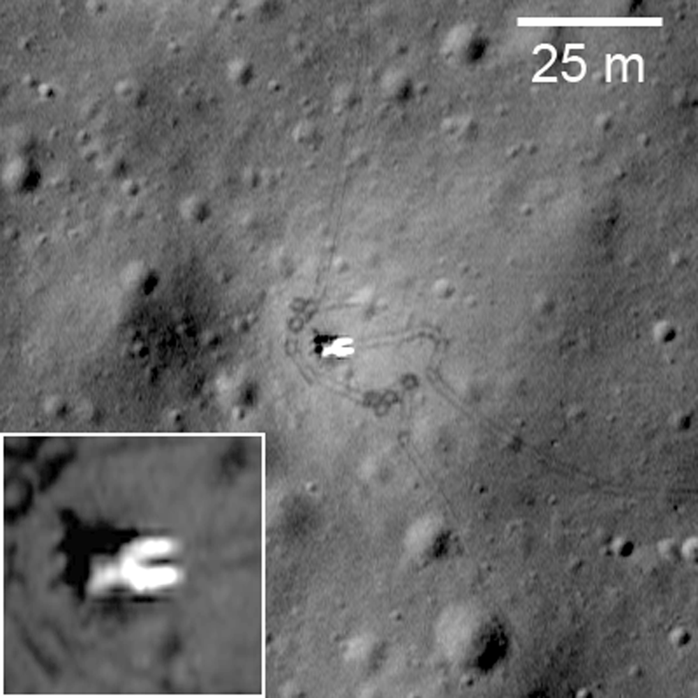
Long and winding road of the last rover deployed on the Moon, Lunokhod-2. Image cropped from a diagonal slice through the rover trail swept up in an extreme close-up of Le Monnier crater August 14, 2012. LROC Narrow Angle Camera (NAC) frame M168000478R, LRO orbit 9892; resolution 41 cm per pixel, angle of incidence 47.65° from 22.11 kilometers [NASA/GSFC/Arizona State University].
The Soviet Union's Lunokhod-2, riding to the lunar surface on the Luna-21 lander, arrived on the Moon January 15, 1973. The 84 kg. rover Lunakhod-2 was afterward deployed and, with the benefit of a robust radioisotope thermoelectric generator to warm itself through the long lunar nights, was teleoperated a total of 37 km, across the southern floor of le Monnier crater, until the following June.

It's not quite as easy to distinguish the twin ruts of the Lunakhod trail in the mosaic of both the right and left-hand frames of LROC NAC observation M168000478. The unusual close-up, from less than half the nominal 50 km altitude, was caught as flight directors prepared to raise LRO's orbit to above 100 km at the end of 2011. Because the camera was considerably closer to the surface, the field of view is quite a bit more narrow, in compliance with the Inverse Square Law, slightly less than one-half kilometer across. LRO was slewed a full 25° off nadir, which resulted in the right-hand frame being very slightly more distorted than the left [NASA/GSFC/Arizona State University].
LROC principal investigator Mark Robinson discussed the Lunokhod-2 mission in detail on March 13, HERE. Also, there are spacecraft panoramas and close-ups of both Luna-21 and Lunokhod-2 at the following links:

Lunokhod-2 revisited (March 13, 2012)
Luna 21 (March 20, 2010)
Lunokhod-1 and Lunokhod-2 (March 17, 2010)

Phil Stooke's familiar survey of the Lunokhod-2 traverse is seen here graced with the scaled mosaic of LROC NAC M168000047, at lower left. The small white box shows the field of view seen at 41 cm resolution in the opening image, above [Google Earth].
ILIADS application perspective of le Monnier, LROC Wide Angle Camera 100 meter global monochrome mosaic draped over LOLA 128 ppd digital elevation model (v.2) [NASA/GSFC/Arizona State University].

Tuesday, July 3, 2012

Craters near Lunokhod-1 officially named

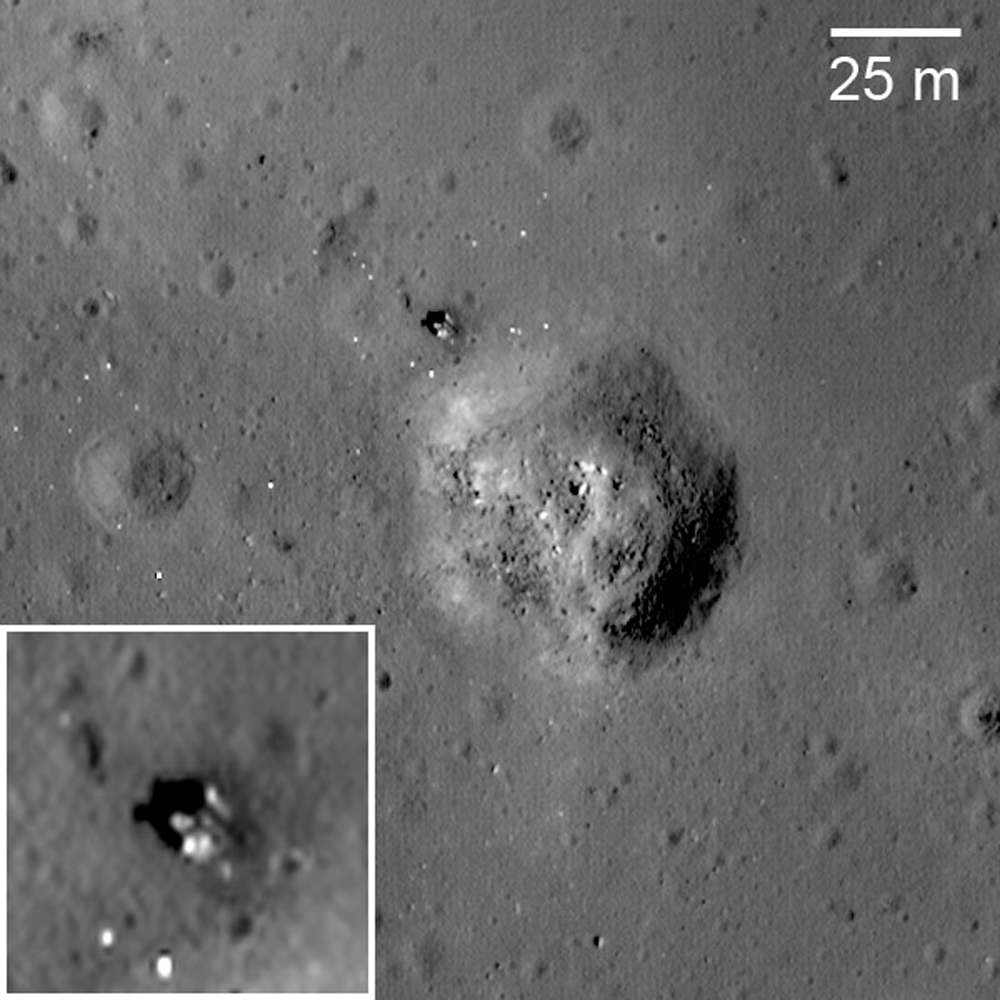
Luna 17, the lander that carried Lunokhod 1 to the surface; debarking ramps for the rover visible extending down to the surface to the right. Many rover tracks are visible around the lander and throughout LROC Narrow Angle Camera (NAC) frame M175502049RE, LRO orbit 10998, November 9, 2011. View the original contextual image with enlarged inset, HERE [NASA/GSFC/Arizona State University].
Olga Zakutnyaya
The Voice of Russia
 

A number of moon craters in the vicinity of Lunokhod–1 lunar rover have been given their own names. They were named in honor of the crew members of the first self-propelled vehicle on the surface of the celestial body.

The experiment carried out more than 40 years ago is to be repeated in the course of “Luna-Resource” expedition which should be launched no earlier than 2015.

The International Astronomical Union has approved 12 new names for small craters on the Moon, and now they have names of the members of the first lunar expedition and scientists who were involved in the project. Despite the fact that these people were not able to walk on the Moon’s surface themselves, they were the ones who led Lunokhod–1 – the first planet rover on the surface of an alien celestial body. All craters are located in the area of the “Sea of Rain” (Mare Imbrium) where the landing vehicle of Luna-17 interplanetary automatic station soft-landed in November 1970. It delivered Lunokhod lunar rover onto the Moon’s surface. All craters are comparatively small, their diameter ranging from 100 to 400 meters.

Thus, the names of Albert, Borya, Gena (in honor of the navigator Gabdulkhai Latypov), Igor, Kolya, Kostya, Leonid, Nikolya, Slava, Valera, Vasya, and Vitya appeared on the Moon.

The Luna-17 spacecraft was built by the design and construction bureau of the machine-engineering plant named after S.A. Lavochkin (now NPO Lavochkin). Lunokhod-1 was equipped with a set of scientific devices to explore the lunar soil. In the course of 10 months that it was working on the Moon, the rover traveled over 10.5 kilometers and sent back to Earth information about the mineral composition and characteristics of the lunar surface.

Lunokhod 1 rover in its final parking place (38.315°N, 324.992°E) on the surface of Mare Imbrium. LROC Narrow Angle Camera (NAC) observation M175502049RE, orbit 10998, November 9, 2011, resolution 33 cm per pixel. View original Featured Image released March 14, 2012 (with enlarged inset) HERE. [NASA/GSFC/Arizona State University].
Lunokhod-1 was controlled remotely via the center for space communications by two crews – five people each who worked in shifts. Each crew consisted of a commander, a driver, a navigator, a flight engineer, and a high gain antenna operator. Thus there were 10 people all together, plus a reserve driver and reserve high gain antenna operator.

Even though by the time Lunokhod-1 was launched American astronauts had already landed on the Moon, the soviet rover was no less a remarkable scientific and technical achievement. Unfortunately, at that time, the meaning of this achievement was overshadowed by the defeat in the race to put a man on the moon. Lunokhod-1, with all its novelty and complexity, was more of a consolation prize. At least that was the general attitude – and analysts might object, of course. Sadly, it was what determined the further development of the lunar program. After the improved version Lunokhod-2 in 1973, there was Lunokhod-3 which never made it to the Moon. As a result, the Lunar Program of the USSR was suspended. Forty years on there has been little progress.

Today it can be said that it was a mistake. Weak consolation might be the fact that space programs in other countries primarily in the United States have also been suspended. However, the comparison might not be accurate – paradoxically as it may sound as though the soviet moon explorations at the end of the “manned moon race” were in a better state (if not financially from the strategic point of view). A continuation of manned expeditions demanded huge resources and clear goals, which probably did not exist at that time. Autonomous expeditions were easier from the point of view of their preparation but brought back much more scientific results. Besides, by that time, complicated initial stages with lots of failures were overcome and so reliability was higher.

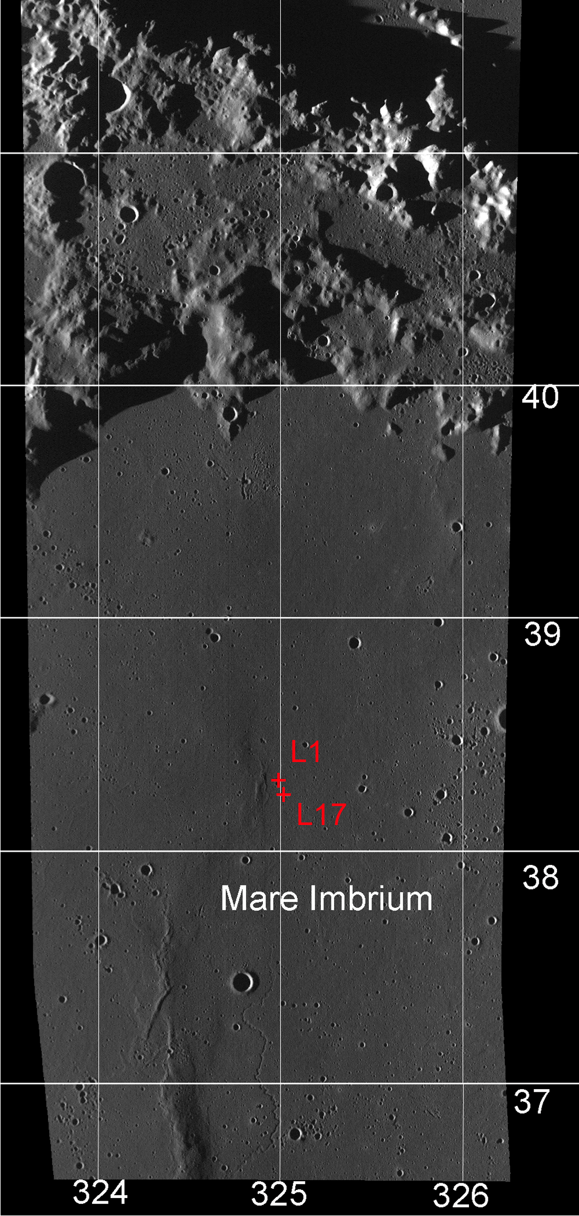
Far western 1970 Landing Zone of the Soviet Union's Luna 17, and the final parking spot of the first remote-operated lunar rover, Lunokhod-1. The French-built laser reflector array deployed from the Lunokhod eluded detection for four decades until its precise location was reacquired by the LROC Narrow Angle Camera in 2009. It's relocation added vital precision to measurements of the Earth-Moon distance that may answer important questions in astrophysics. LROC Wide Angle Camera 100 meter Global Mosaic overlaid upon LOLA topography and assembled using the NASA LMMP ILIADS application [NASA/GSFC/LMMP/Arizona State University].
Something similar is happening to NASA’s Mars exploration program. A long and ongoing exploration of the planet with more and more sophisticated and complex tasks resulted in the fact that the US became a true leader in the Mars programs. That was, in fact, the main argument by scholars who objected to cuts in NASA’s planetary space budget in 2013. In their opinion to lose such an important scientific and technical foundation would be a poor strategic move.

The current plans of Russia in the area of space exploration include returning to the Moon with landing vehicles and a mini-rover – a self-propelled machine which is being developed by an Indian organization for the purposes of the Luna-Resource program. It is planned to repeat lunar soil collection considering previous experiences. If in the course of the first expeditions the soil was collected only in the places of landing – now the goal is to combine the operation of the mini-rover and returning spacecraft. The mini-rover is to determine the most interesting spots and collect soil from them and then the spacecraft should return the samples to the Earth.

New Names Approved for Twelve Small Lunar Craters - The Working Group for Planetary System Nomenclature has approved 12 new names for small craters on the Moon: Albert, Borya, Gena, Igor, Kolya, Kostya, Leonid, Nikolya, Slava, Valera, Vasya, and Vitya. For details, see the map of LAC 24 and the Lunokhod-1 traverse map in the Gazetteer of Planetary Nomenclature [USGS].
Yet as of now these are only plans. Information from the Moon is coming daily. NASA LRO and GRAIL spacecraft continue to work in the Moon’s orbit (two spacecraft which measure lunar gravity fields). Several days ago, the NASA LRO mission published recent images of the lava fields formed as a result of asteroid impacts. The images were taken by LROC – Lunar Reconnaissance Orbiter Camera. This camera is also connected to the Lunokhods – in 2010, the first high resolution images were printed and it was possible to see Lunokhod-1 and the landing spacecraft and the wheel tracks. Interesting that in the same year a group of American scientists announced that they had managed to intercept a pulse from a laser retroreflector on Lunokhod-1.

It is probable that these circumstances have raised the interest in the Lunokhod program again. Naturally, recognition of the achievements of the soviet scientists is satisfying on the one hand, but on the other the interest is mostly coming from western institutions and space lovers. Without the LROC images, the “favourite lunar tractor” would be remembered only by those who are truly loyal to space science. That is why one of the tasks of the future lunar program is not only to learn again how to land and control spacecraft on the Moon, but also how to inform people about it in plain language, and on a regular basis.

Related: Lunokhod-1 revisited (March 15, 2012)

Thursday, June 21, 2012

Excalibur aims Soviet Almaz "to Moon by 2015"

One of two surplus Soviet-era ALMAZ "gunboat" space stations arrives at Excalibur, on the Isle of Man. The company hopes to charge customers $156 million for round-trip orbital excursions to the Moon by 2015. The formerly secret station cores are similar in design to the Soviet Salyut space stations [AmadeusPhotography.com].
Brid-Aine Parnell
The Register

Isle of Man based space tourism firm Excalibur Almaz has said that it will be ready to rocket the rich to the Moon by 2015.

The company told a space tourism conference that it was planning the first test flight of its fleet of second-hand ex Soviet capsules and space stations in 2014 and would be ready to send a well-off civilian on a lunar trip the following year, The Telegraph reports.

The company has so far purchased four capsules and two disused space stations - once part of the Soviet era "Almaz" ("Diamond") program - from the Russians, and plans to get launch rockets from the same source.

Excalibur Almaz is that same firm that said back in 2009 that it would be offering week-long tourist trips in space from 2013 for $35m. So clearly, it's moved a deadline or two before, and the price has also gone up by quite a lot. The firm reckons the first few trips to the Moon will cost £150m, falling to £50m over the next ten years of trips.

Read the full article, HERE.

Friday, June 1, 2012

Who discovered water on the Moon?

Wishing well? The last direct lunar sample was retrieved by the Soviet Luna 24 robotic lander, August 18, 1976. In total darkness, the descent stage landed on rim of this 64 meter crater, on the southeastern volcanic plains of Mare Crisium (12.717°N, 62.222°E), where it was imaged by the LROC Narrow Angle Camera last fall. Enlargement of lander at lower left, LROC NAC observation M174868307L, LRO orbit 10904, November 2, 2011; resolution 43 cm per pixel from 25.57 kilometers [NASA/GSFC/Arizona State University].
Paul D. Spudis
The Once and Future Moon
Smithsonian Air & Space
< /br>
A recent article tells how Soviet scientists studying regolith samples returned from the Moon in 1976 by the unmanned Luna 24 mission first discovered lunar water.  This assertion is based on a paper published in the Russian journal Geokhimiia (vol. 285, p. 285-288, February 1978).  The measurement used infrared absorption spectroscopy to look for the “water band” centered around 2.8 microns, the same technique used recently by several groups to map the water band on the lunar surface regionally from flyby (Cassini and EPOXI) and orbital (Chandrayaan-1) spacecraft.  The Soviet paper claimed to detect water at a level of about 0.1 weight percent.  This high concentration level of water raised my antennae.

The discovery of significant amounts of water would tell us about lunar processes and history as well as provide evidence that water might be manufactured on the Moon to support future exploration.  The first lunar samples returned to Earth in 1969 by the Apollo 11 mission were intensely scrutinized for water content.  Besides being exceedingly dry, the chemistry of the Apollo samples suggested they were created in a completely anhydrous, reducing environment.  Samples from subsequent missions confirmed and extended this initial impression to the point where talk of water on the Moon was mostly dismissed.

A rock returned in 1972 by the Apollo 16 mission displayed visible brownish splotches which turned out to be “rust” in the form of the mineral akaganeite, an iron-hydroxyl phase, with minor amounts of chlorine.  This mineral could have formed by the aqueous alteration of the iron-chlorine mineral lawrencite found in some meteorites.  However a source of water is still needed to create the “rust,” so for several years the source of the water and the nature of the alteration were debated.  Did water come from the inside of the Moon or from an impacting comet?  Did the oxidation occur on the Moon or was it caused by the exposure of the highly reduced lunar sample to humid air (from inside the returning Apollo command module or the Houston summer humidity)?  Different workers had a variety of opinions but with no resolution, interest faded.

But a few inquisitive types didn’t forget it.  Jim Arnold, a chemist from UC-San Diego, resurrected an old idea about permanent cold and dark areas near the lunar poles.  He concluded that over the course of history these areas were cold enough and old enough to have accumulated significant amounts of water from meteorites and comets.  Groups studying the regolith from the Apollo missions measured variable amounts of hydrogen on dust grains; when heated, hydrogen in that dust reacted with metal oxides in the soil producing native metal (iron) and water vapor.  Although done in the laboratory, it was shown that the process could occur naturally on the Moon during the impact of a micrometeorite, whose energy is mostly dissipated as heat.  This heat and the hydrogen on dust grains could “reduce” the material, creating measurable water release.

During the lunar “wilderness years” (i.e., 1976-1994, when no one was going to the Moon) all we could do was speculate and analyze existing samples.  In 1982 a meteorite from the Moon was discovered in Antarctica.  Lunar meteorites provided a new source of samples but even though all had significant exposure to the terrestrial hydrosphere, none of them showed evidence for water-bearing phases.  Attempts were made to map the poles of the Moon from Earth using optical and radar telescopes but poor viewing geometry led to uncertain conclusions.

Two events re-ignited the water debate.  The 1994 Clementine spacecraft probed the south pole of the Moon and found evidence for coherent backscatter near the dark areas.  The team interpreted this as indicating the presence of water ice.  Following Clementine, the Lunar Prospector (1998-1999) neutron detector found elevated amounts of hydrogen near both poles of the Moon, resulting in new interest about the possibilities for water on the Moon.  In recent years, a variety of robotic missions, carrying instruments designed to address the lunar water question one way or another, found large amounts of water in a variety of different forms, locations and concentrations.  We are just beginning to decipher the origins, cycles, and eventual fate of this water.

So what can we say about the Soviet results published in 1978?  No other scientist or group has repeated this measurement on the Luna 24 samples to confirm its validity.  Under a reciprocal exchange agreement with the Soviet Union in the late 1970s, others studied the Luna 24 samples but none reported any traces of water in their samples.  No one in Russia has studied the Luna 24 samples in years (at least to my knowledge), although they still exist and presumably are available for analysis.  The spectral detection of water in the Luna 24 sample should be repeated and then followed up with analyses by other techniques to confirm the water’s presence and to cross-check the amounts claimed.  The published value of 0.1 weight percent (1000 part per million) water seems very high for lunar regolith from equatorial and mid-latitudes; typically, such material contains 10-50 ppm hydrogen, almost two orders of magnitude less than the 1978 reported result.  Finally, even if the old analysis is confirmed, questions about its source are still pertinent; we are still arguing about the origin of the water that made the rust in “Rusty Rock.”

If you’ve stayed with me this far, I hope that if nothing else, this brief history of a lunar controversy has shown that it is difficult (I would say impossible) to assign “credit” to any one paper or worker or group for the discovery of water on the Moon.  In science we always proceed from the knowledge gained by previous work.  Sir Isaac Newton put it well when he famously said that he saw more clearly because he stood on the shoulders of giants.  A lunar scientist’s goal is to study, document and explain, thereby contributing to and advancing our knowledge and understanding of the Moon.

Originally published at his Smithsonian Air & Space blog The Once and Future Moon, Dr. Spudis is a senior staff scientist at the Lunar and Planetary Institute. The opinions expressed are those of the author and are better informed than average.

Thursday, April 12, 2012

Selenokhod GLXP rover ready by summer

Team activity - The implementation of such a large-scale project is impossible without cooperation of various specialists. In team discussions we find powerful incentive to progress it’s extremely exciting and useful for professional development [Selenokhod].
The Team Selenokhod GLXP lunar rover prototype will be finished by summer, developers said on Thursday. Selenokhod is the only Russian entrant among the 26 teams competing for the Google Lunar X Prize.

Selenokhod will move on flats instead of wheels, a design developed for the 4.5-kg Prop-M rovers that traveled on-board the identical Mars 2 and Mars 3 missions. After Mars 2 crashed on the martian surface, Mars 3 achieved the first soft landing there, December 2, 1971. But, for reasons still unknown, all contact was lost with Mars 3 after only 14.5 seconds.

RIA Novosti has posted a video showing
the Selenokhod lunar rover in action
.
Though neither Prop-M rover was successfully deployed on Mars, the Russians are apparently working hard to live up to an inherited legacy of having landed and operated the only robotic rovers on the Moon, in 1970 and 1973.

The team is planning to deliver its 5-kg Selenokhod to the moon on-board Luna-Glob, though that mission was recently delayed until sometime after 2015, past the present X-Prize deadline, and the team reports that contest organizers have not yet indicated whether using a government-funded platform is acceptable.

Saturday, March 17, 2012

The Last Sampler: Failure, then Success

The last direct lunar sample was retrieved by the unmanned Soviet Luna 24 mission, after landing on the northwestern rim of a 64 meter crater on the volcanic plains of southeastern Mare Crisium (12.717°N, 62.222°E), August 18, 1976. Enlargement of lander at lower left (view the LROC Featured Image HERE). LROC Narrow Angle Camera (NAC) observation M174868307L, orbit 10904, during the second recent series of low altitude surveys, November 2, 2011; 43 cm per pixel resolution from 25.57 kilometers altitude [NASA/GSFC/Arizona State University].
Jeff Plescia
LROC News System

Three Soviet missions (Luna 16, Luna 20, and Luna 24) successfully collected and returned pieces of the lunar surface. Before the successful Luna 24 sample return mission in August 1976, Luna 23 was sent two years earlier (November 1974) to nearly the same location in Mare Crisium, but was unsuccessful.

Luna 24 landed in Mare Crisium on 18 August 1976 to complete the unfinished mission of Luna 23. Remarkably, the landing sites of Luna 23 and 24 are only 2.3 kilometers apart.

The region of Mare Crisium where they landed is a typical smooth mare surface with little relief in the immediate vicinity. There are numerous secondary craters scattered across the region, and Luna 24 landed on the edge of one of these. The secondary craters are the result of an impact to the northeast of the landing site, perhaps from the crater Giordano Bruno.

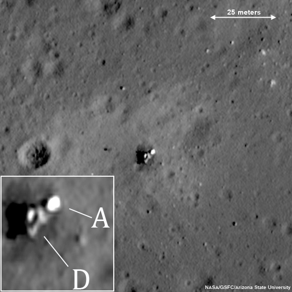
Luna 23 24 regionThe Luna 23 and Luna 24 landing sites. Distance between two landers is 2.3 km. Mosaic of overlapping LROC Nominal Mission NAC frames M119449091L and M119449091R, orbit 2737, January 30, 2010, resolution a half meter per pixel, with the LRO spacecraft slewed 11° at an altitude of 42.91 kilometers  [NASA/GSFC/Arizona State University].
An international mix and match of models made
possible using Google Earth allows this highly
simulated view of Luna 24 today.
Because the precise locations of the various Soviet robotic landing sites were previously unknown to scientists and engineers, finding the spacecraft in LROC NAC images is a high priority. By locating the spacecraft, we gain an understanding of the geologic context of the rock fragments and soils returned by Lunas 16, 20, and 24. Geologic context allows scientists to place the rock fragments and soils into the "bigger picture" within our current understanding of lunar geology, geochemistry, and geologic history. Many of the robotic spacecraft from various nations have been found already in LROC images, but there are a few remaining spacecraft with unknown locations including the early Soviet landers, Luna 9 and 13.

The Luna sample return spacecraft consisted of three flight elements: descent stage, ascent stage, and Earth-return capsule. The entire suite was landed on the surface, and the sample was acquired and placed in the Earth-return capsule. Then, the ascent stage, carrying the Earth-return capsule, was launched to return to Earth. The descent stage of the Luna spacecraft was left on the surface, which is observed in the LROC NAC images of the Luna 16, 20, and 24 landing sites. In the case of Luna 23, the entire spacecraft is still on the surface because it was damaged during landing and was unable to successfully operate and return a regolith sample to Earth.

Stylized rendering of the lift-off of the Luna 24 ascent stage, August 19, 1976. The entire mission took place in the middle of a two-week long lunar night [NPO Lavochkin/RussianSpaceWeb.com/Anatoly Zak].
Unfortunately, Luna 23 experienced a malfunction and hit the surface at a very high velocity. Contact was maintained between Earth and the spacecraft after landing, but a sample could not be acquired. At the time, the cause of the failure was not known, but it seemed probable that the whole spacecraft tipped over upon landing at an unexpectedly high velocity. Indeed, the high resolution LROC NAC image (below) shows the spacecraft lying on its side!

The entire Luna 23 vehicle (descent stage, ascent stage and Earth-return capsule) landed at an unexpected speed and fell on its side. Enlargement of vehicle in lower left inset; D: descent stage, A: ascent stage. (Attendant LROC NAC frame M174868307R) [NASA/GSFC/Arizona State University].

Luna 24 landed on Mare Crisium on August 18, 1976. The launch occurred several days earlier, on August 9, from Baikonur Cosmodrome using a four-stage Proton rocket. The vehicle arrived at the Moon on August 13 and spent five days in orbit before descending to the surface. 

After less than 24 hours, the ascent stage fired, sending the sample back toward the Earth. The spacecraft returned a total of 170 grams (0.375 pounds) of regolith to western Siberia, August 22. 

It is hard not to notice all the bright spots around the Luna 24 descent stage. Are they boulders? Most likely, the small (pixel sized) bright dots are pieces of insulation blankets blown off the descent stage when the ascent stage blasted off to send the sample on its way to Earth. If you look closely you can find this type of debris up to a kilometer away from Luna 24! These bright spots are not present around Luna 23 because there was no blast effect from the ascent stage.

The returned Luna 24 sample surprised scientists as it had unexpected characteristics based on the understanding of Mare Crisium geology at the time. Most importantly, the titanium content and the maturity (or the amount of time the sample was exposed to the space environment) of the sample material were different than anticipated. But how could this be? Based on the geologic context of the lander, the reason for the difference may now be understood. With the precise location of the landing site now known, the LROC images show that the mission sampled impact ejecta from a nearby 64-meter diameter crater. That crater has excavated below the surface bringing up material from deeper lava flows that had not been previously exposed to the space environment. Thus, the Luna 24 sample may not represent nearby Mare Crisium surface materials observed using remote sensing techniques, but rather the subsurface which was only exposed to the space environment for the relatively short time. It’s amazing what geologic context can tell you!

Explore the surroundings near the Luna 24 spacecraft, HERE.

Review earlier LROC Featured Images highlighting Luna 16Luna 20 and Luna 24, and the two Soviet rovers Lunokhod 1 and Lunokhod 2.

Thursday, March 15, 2012

LROC: Lunokhod 1 revisited, too

Lunokhod 1 rover in its final parking place (38.315°N, 324.992°E) on the surface of Mare Imbrium. LROC Narrow Angle Camera (NAC) observation M175502049RE, orbit 10998, November 9, 2011, resolution 33 cm per pixel. View original Featured Image with enlarged inset HERE. [NASA/GSFC/Arizona State University].
Jeff Plescia
LROC News System

Luna 17, carrying Lunokhod 1, landed on the flood basalt surface of Mare Imbrium on November 17, 1970, after entering orbit on November 15. 

Today's Featured Image of Luna 17 and Lunokhod 1 was obtained during a low altitude (33 km) pass providing the highest resolution view yet of the landing site.

The same LROC Narrow Angle Camera frame captured both the lander and the Lunokhod 1 lunar rover, and nearly all the wheel tracks the rover left behind, just shy of 42 years afterward.

Luna 17, the lander that carried Lunokhod 1 to the surface; debarking ramps for the rover visible extending down to the surface to the right. Many rover tracks are visible around the lander and throughout LROC NAC frame M175502049RE. View the original contextual image with enlarged inset, HERE [NASA/GSFC/Arizona State University].

Artist’s conception of Luna 17 on the lunar surface, with Lunokhod descending to the surface [Anatoly Zak/Russian Space Web].
Once Luna 17 landed, ramps were deployed on two sides of the lander allowing for two possible directions for the rover to drive to the surface. In this case, the rover drove down the ramps on the east side of the lander. Rover tracks can be seen extending away from and around the rover. Also note the bright area around the Luna 17 lander; the surface was modified by the exhaust gases from the descent engines such that it appears brighter. This increased contract makes the rover tracks more obvious near the lander.

View of the Luna 17 from the Lunokhod 1. The rover descended from the lander on the opposite side. The wide variety of images, including many other firsts, from the Cold War era Soviet lunar program can be viewed HERE.

Lunokhod 1 traveled a total distance of 10.5 km. It was first commanded to drive south from the Luna 17 lander, making a loop across the mare surface, and then returning north to Luna 17. The rover was then directed to proceed farther north, making a small loop to the west, then returning to its track and continuing northward. The payload consisted of a suite of television cameras, a cone penetrometer to determine physical properties of the regolith, and an X-ray spectrometer to determine the chemistry of the regolith. An X-ray telescope and cosmic ray detector were also part of the payload.

Like Lunokhod 2, Lunokhod 1 carried a French-built laser retroreflector. The vehicle was tracked for a short period during the mission then lost. Once the vehicle was located using LRO/LROC images by the LROC team, it was targeted and recovered using the lunar lasers at the Apache Point Observatory. Because of its location away from the Apollo retroreflectors and Lunokhod 2, recovering Lunokhod 1 is important for lunar geophysical studies.

The rover’s journey across the surface formally ended on October 4, 1971, after 11 lunar day-night cycles (322 Earth-days). Attempts to contact the rover after the lunar night that began on September 14, 1971 were unsuccessful, apparently due to a failure of some component of the rover during the lunar night.

Northern Mare Imbrium showing the location of the Luna 17 landing site and the final position of the Lunokhod 1 rover. View the larger LROC WAC context image HERE. [NASA/GSFC/ Arizona State University].

Explore the Lunokhod 1 site on your own HERE.

Revisit about the earlier LROC "rediscovery" of Lunokhod 1 HERE.

Tuesday, March 13, 2012

LROC: Lunokhod 2 revisited

The tele-operated Soviet Lunokhod 2 rover, the last lunar rover deployed on the Moon, parked facing southeast with the lid still open 39 years later. Rover tracks extend north to this final parking place. The inset is a zoomed in view, the main body is labeled B and open lid labeled L, with the instrument suite (including its French-built laser-ranging retro-reflector array, still in use) on the front labeled I. LROC Narrow Angle Camera (NAC) observation M175070494, orbit 10934, November 4, 201; resolution 30 cm per pixel [NASA/GSFC/Arizona State University].
Mark Robinson
Principal Investigator
Arizona State University

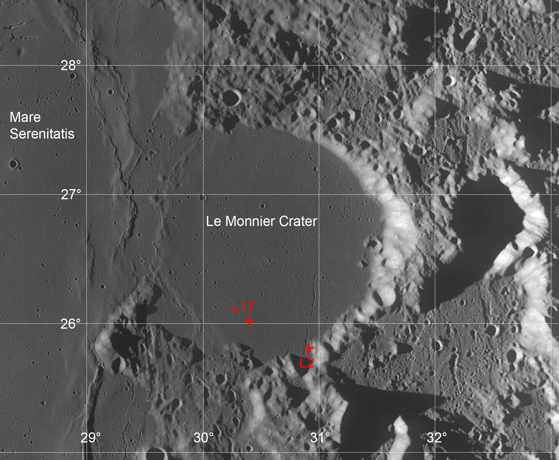
The Lunokhod 2 rover is still parked on the floor of the crater Le Monnier (25.830°N, 30.914°E). This NAC image was taken when the spacecraft was only 24 km above the surface, zipping along at about 1.6 km/sec (about 3600 mph). The spacecraft had to turn on its axis 27° to view the rover. The resolution is about two times higher than usual!

The Lunokhod 2 rover was carried to the surface on board the Luna 21 spacecraft. Lunokhod is the English translation of the Russian word “Луноход”, meaning Moon Walker. The ensemble was launched on 11 January 1973 and the landing occurred on 15 January in Le Monnier crater on the eastern margin of Mare Serenitatis. The coordinates of the landing site are 26.005°N, 30.406°E (on the basis of nine observations) at an elevation of -2769 m (1734630.9 m radius).

Le Monnier crater lies on the eastern wall of the Serenitatis basin. Lavas that compose Mare Serenitatis also flooded the floor of this 61 kilometer diameter ancient crater. The two red crosses indicate the locations of the Luna 21 lander (L21) and the ultimate  parking spot of the Lunokhod 2 rover (L2) after enduring three full lunar nights. View the original full resolution context image HERE [NASA/GSFC/Arizona State University/USGS/JAXA/Phil Stooke/Google].
Lunokhod 2 is about 170 cm (5’ 7”) long x 160 cm (5’ 3”) wide x 135 cm (4’ 5”) tall, and it is almost circular when viewed from above. The vehicle had eight wheels and could travel at either 1 km/hr or 2 km/hr (0.6 and 1.2 mph). The lid on the top of the rover served to provide solar power and to keep the vehicle warm at night. When the lid was opened, the solar cells collected energy to operate the rover. At night, the lid was closed and a fluid heated by the decay of Polonium-210 kept the rover warm. The rover was controlled remotely by a team of Soviet controllers on Earth.

Lunokhod rover in publicity still. Note the mesh wheel design and LRRR on the extended instrument suite housing [Russian Space Academy].
During its 37 km traverse, Lunokhod 2 headed south from the landing site and into the highlands from the southern rim of Le Monnier crater. Lunokhod 2 had difficulty on the slopes of the southern rim so it was turned northward and commanded to backtrack to the flat mare basalts that form the floor of Le Monnier. It then continued eastward across the crater floor eventually encountering a 250 wide north-northeast trending rille named Fossa Recta (Straight Rille).

The Luna 21 lander with ramps deployed on both sides,
to the northwest and to the southeast. LROC NAC
M122007650L [NASA/GSFC/Arizona State University].
Lunokhod 2 drove off the lander to the northwest and circled around to the east. Several turns were made as the rover photographed the lander. It then departed and headed south.

The rover had to work its way down the rille wall and across the floor before finally climbing out on the east side. Lunokhod 2 continued north before reaching its final position. The mission officially ended on 4 June 1973 due to a failure of the rover. Apparently on 9 May, the rover’s lid touched a crater wall and become covered with fine-grained lunar regolith. That regolith was dumped onto the radiators when the lid closed. Subsequently, when the lid opened, the rover overheated and failed.

The scientific payload on the rover included three television cameras for navigation, four panoramic cameras, a cone penetrometer to test the lunar regolith, a solar X-ray experiment, a magnetometer, radiometer, and laser ranging retroreflector.
Luna 21 lander as seen from the Lunokhod 2 rover. This view as taken from south of the lander looking to the northwest. The tracks around the east side of the lander are quite apparent, note the small berms of regolith that were pushed up as the rover turned. Lunation 1, Session 4, Panorama 12 [RSA]..
Examine the regional geology that Lunokhod 2 was exploring, HERE (hint: sample 4493, line 15645; look to the south for some spectacular rover tracks).

First LROC Featured Image of the Lunokhod rovers.

Saturday, December 3, 2011

"Boy, that sure looks like Luna 9!"

Fig. 1  Idealized Google Earth icon of Luna 9, the first soft-landing on the Moon (the first soft-landing anywhere other than Earth), February 3, 1966. The cartoon Russian spacecraft is pinpointed more than 30 kilometers northeast (8.0°N, 296.0°E) of an 'official' landing site (7.08°N, 295.63°E) because investigators say the 'official' coordinates place the lander well beyond the eastern rise, at left on the horizon above. That location doesn't appear to match the landscape seen in the panoramas returned to Earth. The object identified as a likely candidate, at 7.153°N, 295.630°, is less than 2.8 km north of the official coordinates, but at a notably higher elevation on that same rize, perhaps where fewer obstructions are to be found on the local horizon [NASA/USGS/JAXA/Google].
Joel Raupe
Lunar Pioneer

The problems encountered by the Russian Federation after the launch of Fobos-Grunt on November 9, when compared with the apparent ease NASA is experiencing, thus far, in getting Curiosity through the present Martian launch window, might tempt fools to dismiss Russia's interplanetary skill. Russian morale might be threatened but we're reminded yet again that Space is relentlessly intolerant of cutting corners or under-funding. The Great Galactic Ghoul, that cosmic gremlin supposedly spoiling to ruin Mars and Moon missions alike, spends most of its time here on Earth.

Off-planet, when Institutional Memory is applied efficiently, the Russians are a match for anyone.

Friday, December 2 is the 40th Anniversary of the first soft-landing on Mars, and Russia's Mars 3 lander was successful, though the lander operated on the surface only 20 seconds, back in 1971. Saturday, December 3 is the 12th Anniversary of the loss of America's Mars Polar Lander in 1999. Thus, the success of Curiosity is by no means a sure thing. When space exploration begins to look too easy disaster waits patiently at the door.

A planned Russian return to the lunar
surface may ultimately benefit from a post-
Fobos-Grunt shakeout
[RussianSpaceWeb].
The first vehicle soft-landed on the Moon (and the last one landed there, a decade later) were strictly Made in Russia. Embarrassing and often tragic, spectacular failure also often fuels political will, without which governments accomplish nothing.  After a latter-day purge of Russia's unmanned mission contractor NPO Lavochkin, the legacy of Fobos-Grunt may help guarantee eventual success for Luna-Grunt and the other lunar missions Russia has in the works.

If all goes well, beginning next month, the United States will support five spacecraft exploring the Moon simultaneously, the most prominent among them the record-smashing LRO. Following decades of a near total neglect of its hard-won and expensive lunar legacy, America owes a revival of interest in Earth's Moon directly to the loss of Columbia in 2003.

An early priority for LRO was a survey of human artifacts on the Moon. Delivering spectacularly on that assignment were Mark Robinson, principle investigator for the Lunar Reconnaissance Orbiter Camera (LROC), together with his team at Arizona State University. Their most newsworthy success, quite naturally, were many high resolution history-making photographs of the relics and footprints from the Apollo program.

Fig. 2  Planitia Descentus - Latin for Plain of Descent, a human distinction for an otherwise indistinct borderland along the western edge of Oceanus Procellarum, where Luna 9 came to a tilted stop February 3, 1966.  The yellow dot on the rise at center bottom on both maps makes the location of an object that could be Luna 9. These comparative maps of the same 14,300 square kilometer area (centered near 8.48°N, 64.47°W) are (top) LROC WAC DTM  juxtaposed with (bottom) LROC WAC mosaic, each from LROC/ASU QuickMap (250 m/pp resolution). [NASA/GSFC/Arizona State University].
A steady stream of LROC Narrow Angle Camera (NAC) views were released during the LRO Nominal Mission revisiting the remains of a host of U.S. and Soviet spacecraft, both impact craters and the intact sentinel spacecraft themselves following hundreds of lunar days and nights. Each of these Featured Images released by LROC has fired the imagination while calibrating and confirming some very old, often incomplete sets of data.

Finding Lunokhod 1 (38.316°N, 324.996°E), for example, was an overdue accomplishment. It was the first robotic rover on another world, equipped with a laser range reflector that had eluded detection for decades. Its addition to the passive network of reflectors set up by Apollo 11, 14 and 15, together with its French-built twin on Lunokhod 2 allowed the measuring of the Earth-Moon distance to within 3 mm, the missing tolerance needed to test whether a range of physical laws were exclusive to our neighborhood in the universe.

A compendium of LRO's definitive findings, LROC Coordinates of Robotic Spacecraft, put together by Samuel Lawrence at ASU, was released April 5, 2010.

Though the list has not been updated since, it's still spectacular. For the first time, for example, anyone with an Internet connection can see precisely what happened when the third stage of the Saturn V that pushed Apollo 13 around the Moon impacted with the lunar surface. And planetary scientists have a precise date on a fresh impact crater on the Moon, as well; a standard useful for dating optical maturity and space weathering. We no longer have to imagine if the footprints are still there and decades of doubters can precisely see for themselves how the astronaut's surface photography matches the landscapes as seen only 45 (and more recently 25) kilometers away.

Still, the table put together by Lawrence can't yet be comprehensive.

A search for the place where Luna 2 became the first man-made object to impact another world in 1959, for example, is fraught with uncertainty. Those official coordinates are necessarily wide of mark, if only because the precise location of the Moon itself, and its surface, would never again be less well understood than before the Russian measured the time of impact for Luna 2.

A search for Luna 2 using those rounded-off coordinates brings the investigator west of Autolycus, to a 22 square kilometer area where there are at least two, perhaps three, fresh craters with the proper wispy signatures. One of them shows signs of a unique debris field, perhaps dotted with a cluster of the impact-resistant Soviet flag-engraved metal balls reportedly loaded on Luna-2. A surface expedition will be needed, in other words. As amazing as it is, however, even the LROC Narrow Angle Cameras have their limits.

At the very edge of those limits is Luna 9, the 99 kg.lander the Soviets succeeded in soft-landing on the Moon on February 3, 1966. In Multiple NAC footprints covering the target area uploaded to the Planetary Data System, even by April 2010, it was easy to see the LROC team had already earnestly tried to find that historic relic. But Luna 9 wasn't on the list put together by Lawrence.

Fig. 3  A closer look at the Plain of Descent.  The rectangle matches a 2.5 km-wide cross-section of LROC NAC observation M137970706R, the area seen in Figure 6a, below. The small white dot marks a spot less than a kilometer south of the rectangle, the official Luna 9 landing site, and the white dot inside the rectangle marks the location of an "object of interest," something that seems to be a Luna 9, in the two NAC observations detailed below.  The 'mid-morning' view above is a 41-km-wide field of view taken from LROC Wide Angle Camera (WAC) observation M160376850C (604 nm), LRO orbit 8769, May 18, 2011; incidence angle 55.42° with a resolution of 57.55 meters per pixel, from an altitude of 40.49 km [NASA/GSFC/Arizona State University].

As noted expert on lunar artifacts Phil Stooke of the University of Western Ontario put it, finding the very first vehicle soft-landed on the Moon was "problematic," even with the proven sensitivity of the twin LROC Narrow Angle Cameras. 

There is lingering dispute about the true landing site, though the central difficulty in finding Luna 9 is probably the small spacecraft's low profile. Its instrument housing is barely at the half-meter limit to the LROC NAC Nominal Mission resolution. And, because discussing Luna 9 without seeing its mission in the context of the Cold War would be incomplete, a brief comparison with Surveyor, its very real competition, is necessary.

The Russians beat Americans to the Moon in 1966 by only five months. Samuel Lawrence had already written up and released LROC's first views of "Surveyor 1 - America's first soft lunar landing," on September 30, 2009. That observation (M102443995L) swept up the first U.S. lander very early in LRO's Commissioning phase, in orbit 272, when LRO was still flying at twice its Nominal mission altitude, from 102.4 km overhead. That survey of the floor of Flamsteed P was photographed at less than half of the planned LROC NAC resolution; at 1.08 meters per pixel, the Surveyor 1 tripod in profile was barely visible, identifiable mainly in its long shadow at local sunset.The Surveyor design featured a central mast with square solar panels at the top, standing high like a flag. That aided in identifying all five of the successful Surveyor landers, right they sat. 


Unlike its Google Earth icon, seen in Fig. 1, Luna 9 was not standing like an egg, balanced on one hemisphere. After its landing and activation Luna 9 was at tilted, and from slight changes in the background seen in its five photographic panoramas we can tell Luna 9 shifted slightly after deployment.

Fig. 4  Simulated oblique view west by northwest over the area of interest from a point 28 km over the western Oceanus Procellarum. After years of deconstructing the five panoramas captured and returned to Earth by Luna 9, many reliable experts have come to doubt the accuracy of the official landing site (coordinates on the left, at "-1310 m" elevation).  Some believe Luna 9 must have landed somewhere in the plain to the north (on the right, marked "-1640 m").  If the object detailed in Figures 5 and 6 below is Luna 9 then the lander came to rest at a point less than three kilometers and almost due north of the official coordinates ("-1170 m"), and at least 140 meters higher in elevation.  After studying the LROC WAC Digital Terrain Model of the area (Fig. 2) the hills, contiguous with other features surrounding the Plain of Descent, appear to be the highly degraded rim of an ancient, mostly buried crater.  -Image created using ILIADS application, developed by NASA's LMMP project; photography from LROC WAC Global Mosaic with elevations from LOLA altimetry (v.2). [NASA/GSFC/ARC/LMMP/ASU].
The low profile and squat, efficient design of Luna 9 have made it difficult to definitively locate, either somewhere in the expansive plain to the north or near the official position somewhere on a 500 meter high hill, nor on their slopes. All of the area was extensively photographed from LRO, from high altitudes and low, under high Sun and low Sun, with LRO rolled and looking down from directly overhead. If the little vehicle has been captured (which seems certain) what would distinguish its egg shape from thousands of boulders more or less the same size?

It's a safe bet Samuel Lawrence and others on the LROC team encountered this difficulty head-on, with the determination and resourcefulness of a Cold War photo-analyst pouring over U2 photographs of Cuban missile sites. 

In fact, it would be the height of presumption on our part to claim to have done anything more than retraced their steps. It's impossible to believe a candidate object we stumbled on, within their choices of photographic session, hasn't already been considered or scratched off the list. Were it not for something that may turn out to be simply an artifact of digital compression we wouldn't take another look.

Let's just say, "boy, that sure looks like Luna 9!"

What follows are two sets of images, selected from two separate LROC NAC observations, focused on an "object of interest" at sunrise (Figures 5a and 5b), when the Sun was less than 5 degrees over the east horizon, when long shadows allow for depth perception, and then (in Figures 6a - 6d) where, at less than 8° north of the equator, the Sun was high overhead and depth perception gives way to a search for subtle variations in brightness or optical maturity.


Fig. 5a   The full 2.5 kilometer-wide field from LROC NAC M132071202L orbit 4597, June 25, 2010; with resolution greatly reduced from the original 0.48 meter per pixel resolution captured from 40.49 km altitude, incidence angle 85.57°. The yellow rectangle is the area shown at full resolution in Fig. 5b, immediately below. The yellow dot is our "object of interest," so to speak, indicated with an arrow in at full resolution below. The object certainly casts a shadow, as anything with a profile would when caught in naked morning sunshine on the Moon. It is also seemingly brighter than other similarly sized objects in the roughly 238 meter-wide field of view seen below.  [NASA/GSFC/Arizona State University].
Fig. 5b  Full resolution, and very non-definitive rendition of the Object of Interest, again, from LROC NAC M132071202L The object appears to be situated within the west slope of a 10 meter crater, whose interior is very darkened with shadow. Since Luna 9 arrived on the Moon not long after local sunrise, this doesn't help identify the object as Luna 9. The larger, similarly bright object to the southwest is too large to be Luna 9, but its size and location relative to the object of interest makes a case for it being part of the larger lander bus [NASA/GSFC/Arizona State University].
On the 500 meter hills, south of "the plain of descent," under an afternoon Sun:

Fig. 6a  Backing away once again, shifting perspective slightly to the west, with the Sun nearly overhead, this is the field of view within the rectangle back in Fig 3, and slightly west, overlapping the area in Fig. 5a, another 2.5 km-wide area taken this time from LROC NAC M137970706R, orbit 5466, September 1, 2010, from 45.57 km in altitude (incidence angle 29.64°). The area in the white rectangle is the field of view enlarged in Fig. 6b, immediately below [NASA/GSFC/Arizona Sate University].
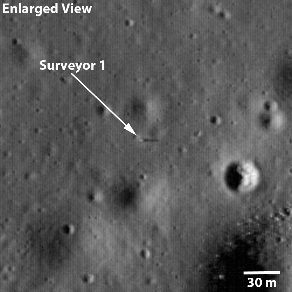
Fig. 6b  At 40 percent of their original resolution, line 14775 to 15556 by sample 3964 - 4544 from M137970706R. (The dim dark line is an artifact "junction" between line 15000 and 15001). And, like a Russian Doll, the square box above is the roughly 290 meter-wide field of view seen at 100 percent of the original observation's 0.5 meter per pixel resolution seen in Fig. 6c, immediately below [NASA/GSFC/Arizona State University].
Fig. 6c At full resolution, lines 15001 - 15580 by sample 3964 - 4543 from LROC NAC M137970706R. Compare this with Fig. 5b, above and, once again, what is seen under differing lighting conditions on the Moon is clear. When happening upon this candidate object under a high Sun, something catches the eye [NASA/GSFC/Arizona State University].
Fig. 6d  Taking  LROC NAC M137970706R  well beyond its true limit of resolution we stumble upon what might be Luna 9, resting on the west interior slope of a shallow 10 meter crater, perhaps even afterwards sliding slightly between photographic panoramas, February 3, 1966. Under an early afternoon Sun, after being enlarged 400 percent with a super-sampling algorithm, what appear faintly as three of the spacecraft's four instrument-shielding petals (the fourth presumably in its shadow) somehow popped out from the background. No intentional fudging was done to the original brute-force enlargement (See Fig. 7) [NASA/GSFC/Arizona State University].
Fig. 7 A simple enlargement to 400 percent of the half-meter per pixel resolution native to LROC NAC observation M137970706R turned up this object, certainly an oddity if it is not Luna 9. As demonstrated in the hackneyed animated image (Fig. 6d), the object meets the profile, is barely less than 3 kilometers due north of its official landing site, about 140 meters higher in elevation, on a broader slope with presumably less obstructed horizon.

Fig. 8 The view south from Luna 9, February 3, 1966.


Using the popular open-source program Orbital Simulator, "reseferina1" created this interesting simulation of the Luna 9 mission in 1966. Though fun, it too, unfortunately, made the thing look far too easy. The originating YouTube page is HERE.