Showing posts with label Mare Tranquillitatis. Show all posts

Tuesday, August 12, 2014

Complimentary craters, south of Maclear

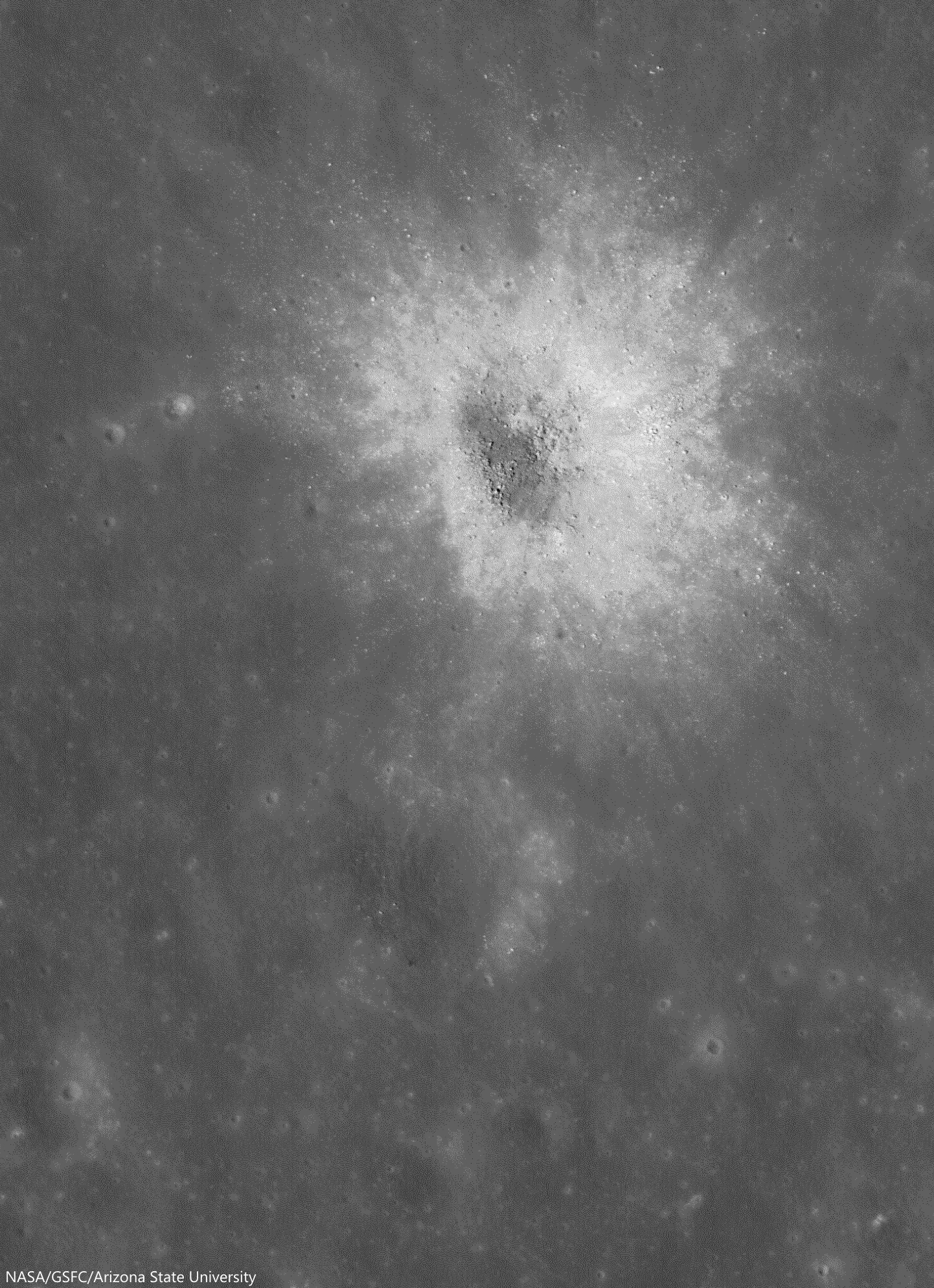
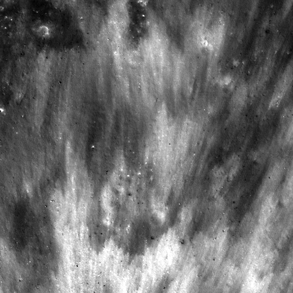
South of Maclear in northwest Mare Tranquillitatis, two complimentary craters of very similar location, size and origin, but additionally of widely different ages. The relentless bombardment of small debris "gardens" the lunar surface at an average rate of 3 mm every 2 million years. In addition to the nearly billion year long cycle of cosmic ray dark-reddening, "space weathering" ages, or "optically matures" the lunar surface at a predictable rate, adding to crater counts and super-positioning another useful tool to the craft of dating lunar features from a distance. LROC NAC observation M131515002R, LRO orbit 4515, June 18, 2010; 79.75° sunrise incidence angle, resolution 85 cm from 40.68 km over 9.09°N, 20.14°E [NASA/GSFC/Arizona State University].
Raquel Nuno
LROC News System

There are several distinguishing properties of craters that help lunar scientists determine their ages. As craters get older their appearance changes through exposure to solar wind bombardment and other impacts (collectively called space weathering), and even gravity has an effect.

Effects of the solar wind lower the reflectance of the surface; so regolith (soil) that was excavated by recent impacts has higher reflectance than the background surface, this is why small young craters have visible crater rays. New impacts pulverize rocks that were ejected during the formation of an older crater and disturb the shape by causing moonquakes. Also, gravity works to alter the shape of a crater by pulling material down its walls in a process called slumping, this causes craters to have a smoother appearance.

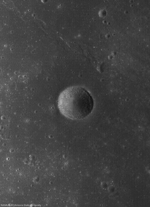
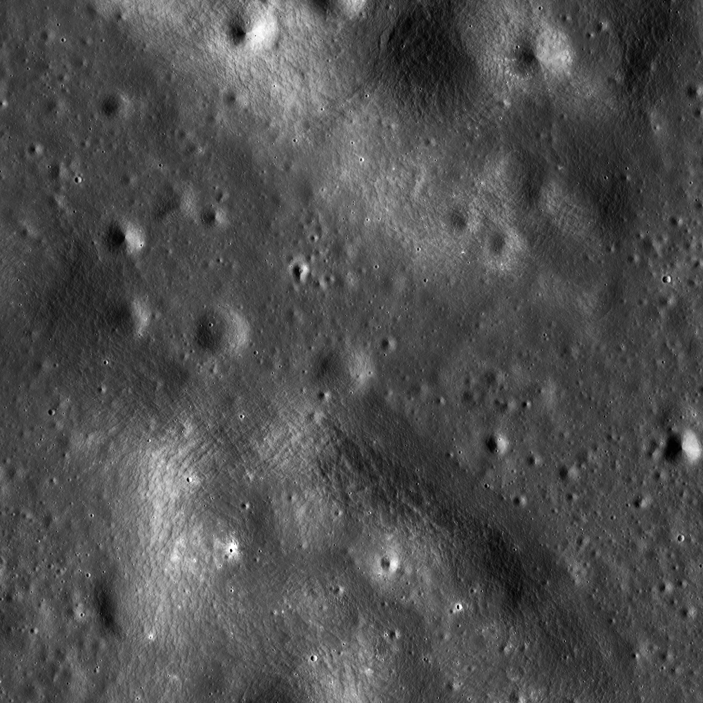
1.69 km field of view from LROC NAC Commissioning observation M106748283R, LRO orbit 873, September 5, 2009; 29.84 low-angle incidence, resolution 1.17 meters from 133.64 km over 9.82°N, 20.15°E [NASA/GSFC/Arizona State University].
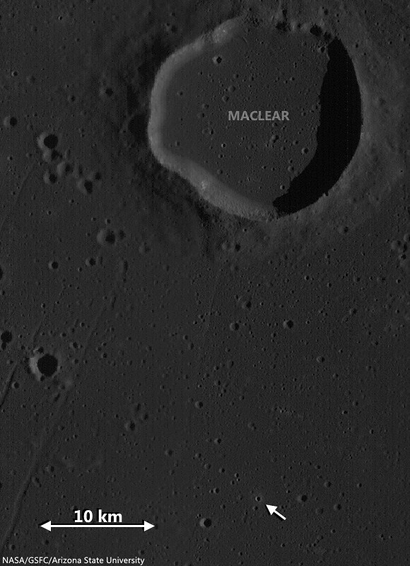
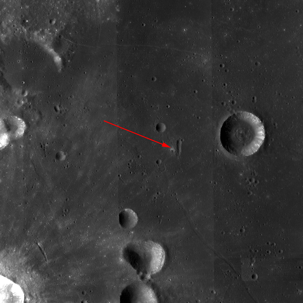
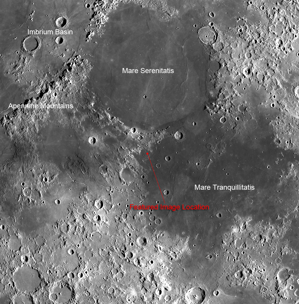
Today's Featured Image showcases two similarly sized adjacent craters (each ~500 m in diameter) located in Mare Tranquillitatis (see WAC context image below) with very different appearances. The area surrounding the top crater is littered with boulders in all directions. Wheras the more southerly crater has only a few rocks near its rim. Where did the boulders come from in the first place? And did the lower crater originally have boulders?

Locating two co-located 500 meter "complimentary craters" (arrow) good for comparing rates of general space weathering, in west-northwest Mare Tranquillitatis. LROC Wide Angle Camera (WAC) monochrome (566 nm) observation M131514941C, captured simultaneous with the NAC observation opportunity shown in the Featured Image at the top of this post. LRO orbit 4515, June 18, 2010; 79.75° incidence, resolution 57.7 meters from 40.72 km over 10.17°N, 20.14°E [NASA/GSFC/Arizona State University].
Since the mare basalt formed from layers of lava that hardened into solid rock, it is likely the boulders are coherent fragments of those thick layers (a few to tens of meters thick) that were broken up and ejected during the impact event. Since these two craters are so close and both formed in the mare it is very likely that the lower crater also had a large grouping of boulders in its ejecta field. The dissimilarity between these two craters is most likely due to age difference. Over time (perhaps a couple of billion years) the original boulders around the lower crater were slowly ground down by micro-meteorite bombardment - think of this process as cosmic sand-blasting! The boulders around the younger crater (top) have not had time to be pulverized by other impacts, but stick around for a billion years and you can watch these boulders slowly disappear!

Explore the full resolution NAC HERE.

Related Posts:

Friday, May 30, 2014

Eroding crater walls at Maskelyne B

High reflectance material poured down the walls toward the floor of Maskelyne B crater, indicating interbedding of high reflectance with low reflectance layers in its walls. Image field of view is 2800 meters, vertical relief across this view is 1300 meters in depth. LROC NAC mosaic M137360167LR, LRO orbit 5376, August 25, 2010; 35.77° incidence angle, resolution 51 cm from 47.04 km [NASA/GSFC/Arizona State University].
Aaron Boyd
LROC News System

Maskelyne B (8.34 km; 1.97°N, 28.96°E) is a simple crater in southern Mare Tranquillitatis, about 1800 meters deep across only 8 km. The stratigraphy revealed in the walls of the Maskelyne B impact crater are clues to the volcanic history in Mare Tranquillitatis.

Perhaps there is older, higher reflectance anorthositic material beneath younger and darker basaltic lava flows. Layering also occurs by large impacts ejecting and emplacing older subsurface material on the local terrain. The most likely cause for the layers seen in Maskelyne B is from the erosion of large coherent blocks of unexposed mare basalt over mature space-weathered regolith. High resolution spectral imaging or samples of this area would resolve this ambiguity.

Maskelyne B (8.34 km; 1.97°N, 28.96°E) The region in Mare Tranquillitatis was a guidance landmark for the Apollo 11 expedition in 1969, and the terrain shares much with the sampled Tranquility Base only 170 km to the southwest by west. LROC WAC observation M129099228C (566 nm), LRO orbit 4158, May 21, 2010; 52.61° incidence angle, resolution 56.14 meters from 39.87 km [NASA/GSFC/Arizona State University].
The surface of Mare Tranquillitatis was built up over time by lava flows between 3.5 and 3.9 billion years ago creating stratigraphic units that are visible today. Maskelyne B formed long after the lava cooled. As the crater walls are eroded away by smaller impacts, the higher reflectance material is exposed and the surface is ground into boulders, cobbles, and dust.

High-resolution reproduction of the LROC NAC mosaic M137360167LR, and the northwest semicircle of Maskelyne B is available HERE [NASA/GSFC/Arizona State University].
The contrast between the light boulders and dark slopes draws the eye and piques curiosity to know what lies beneath the surface. See more of Maskelyne B and the surrounding area below.

Related Posts:

Thursday, May 1, 2014

Elongated crater in west Tranquillitatis

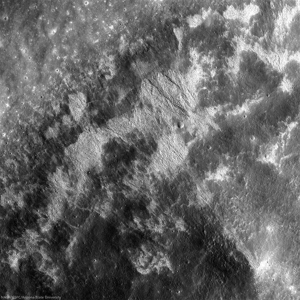
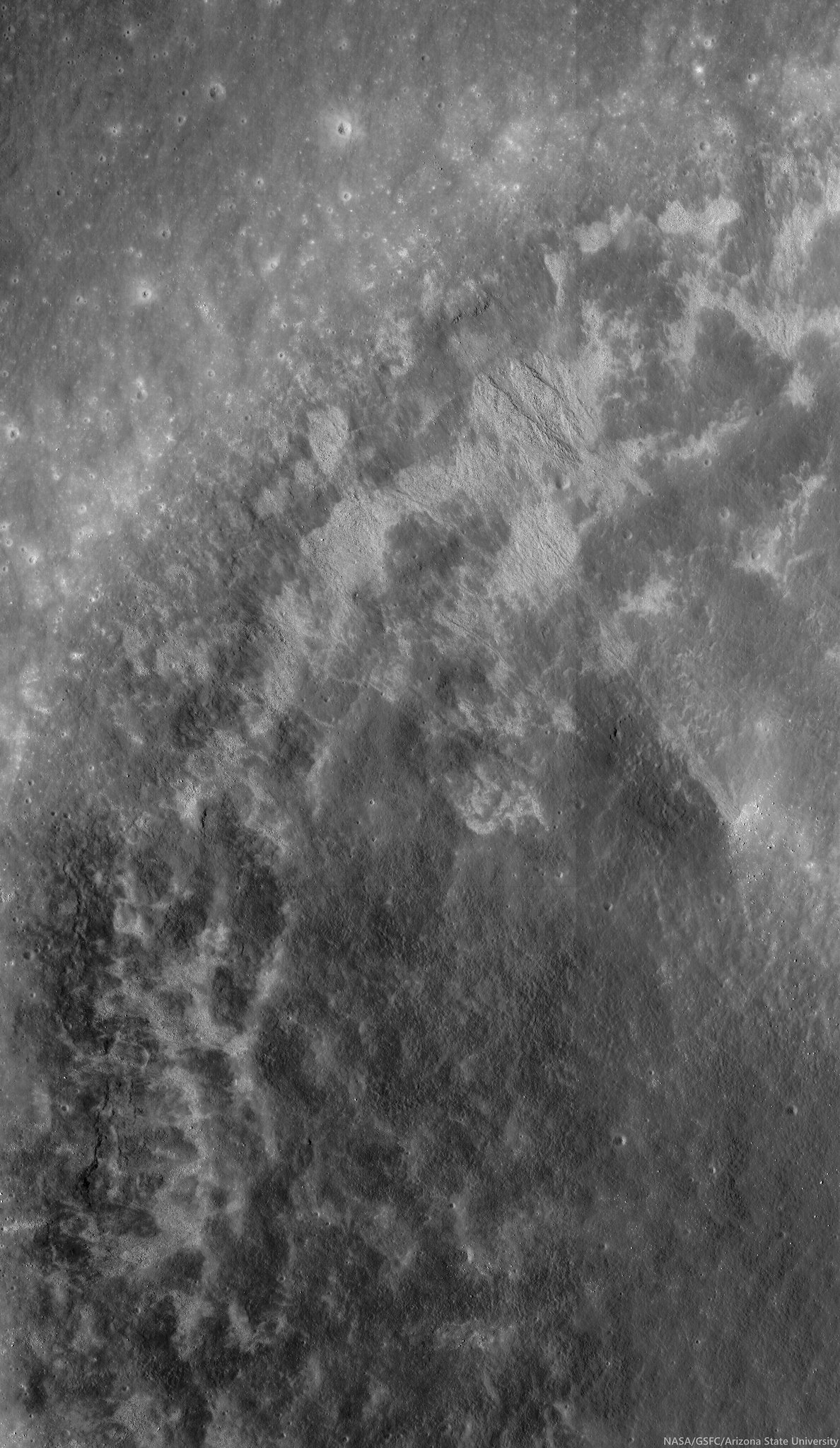
Wall and Rim of Arago E: Full resolution sample from and unusually low-altitude, LROC Narrow Angle Camera (NAC) observation from only 40 km altitude. The sample above shows detail of the northeast wall and floor of Arago E, an excavation of the complex Arago area of western Mare Tranquillitatis. The floor is peppered with boulders that have tumbled down the crater wall. This roughly 800 meter sq. field of view was cropped from LROC NAC M155084711R, LRO orbit 7989, March 18, 2011; resolution 47 cm per pixel, angle of incidence 10° from 40.02 km [NASA/GSFC/Arizona State University].
Raquel Nuno
LROC News System

Arago E (8.5°N ,22.71E°) is an elongated crater located in Mare Tranquillitatis, north of the July 1969 landing site of Apollo 11.

An unusually shaped crater, Arago E is nestled between two wrinkle ridges (see Wide Angle Camera context image below), tectonic features formed by the deformation of the basaltic rocks that make up the lunar maria.

Massive maria lavas placed an extra load on the surface, and these deformations are adjustments of the surface due to the unrelenting force of gravity buckling the rock.

Mosaic from the left and right LROC NAC cameras, LROC NAC observation M155084711R and L, allowing a wider look at the 3.7 km c 6.7 km interior of Arago E. View the original (1000 x 1710) reproduction HERE [NASA/GSFC/Arizona State University].
Elongated Arago E and the ruffled surface of west Tranquillitatis: High angle, early morning illumination highlights the undulations of the Tranquillitatis terrain between 25.5 km Arago, at lower left (6.15°N, 21.43°E) and the elongated, still partially shadowed interior of Arago E at upper center in this roughly 75 km-wide field of view from a mosaic made from two sequential LROC Wide Angle Camera passes, in orbits 6772 and 6773, December 13, 2010. 60 meters per pixel resolution, angle of incidence 74° from 44 km. View the original reproduction (1223 x 1951) HERE [NASA/GSFC/Arizona State University].
This crater's elongated shape is perhaps due to an oblique impact, which impart excess horizontal momentum into the surface leaving an elongated shape. However, for this to happen it's thought a progenitor projectile had to have been arriving from less than 30° above the horizon.

Volcanic vents can also display elongated shapes but don't exhibit raised rims and usually lack a flat floor from pooled impact melt, and both features are seen in Arago E.

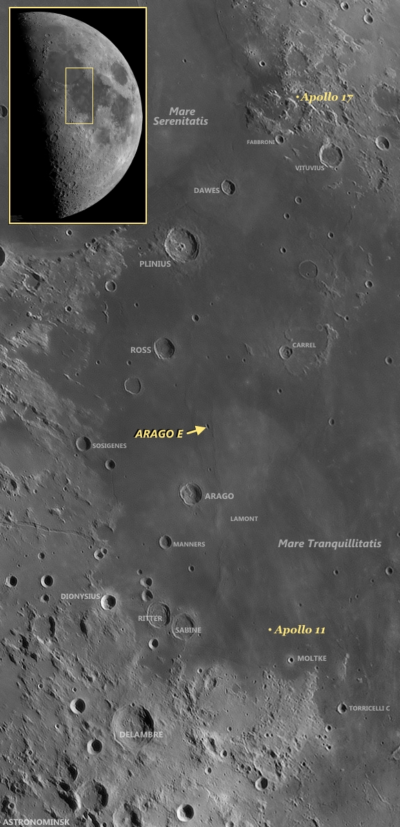
Earthview context for Arago E: Arago and Arago E are familiar landmarks in telescopic views from Earth. With only a little practice, even amateurs, using modest telescopes can pick them out and, in their mind's eye at least, also pick out the relatively nearby landing sites of Apollo 11 and Apollo 17, the first and the last Apollo surface expeditions. The full-scale mosaic (inset) was "stacked" from ten frames April 21, 2010 by Yuri Goryachko, Mikhail Abgarian & Konstantin Morozov of Belarus [Astronominsk].
A picture of this crater was taken from orbit during the Apollo 15 mission. (You can see it HERE.) How does the LROC NAC observation, at full resolution HERE, compare?

Related Posts:
A Stark Beauty All Its Own
Constellation Region of Interest at Mare Tranquillitatis
Wrinkle Ridges in Aitken Crater
Wrinkle Ridge vs. Impact Crater
Not Your Average Crater

Thursday, March 13, 2014

Stratification in a Tranquil Sea

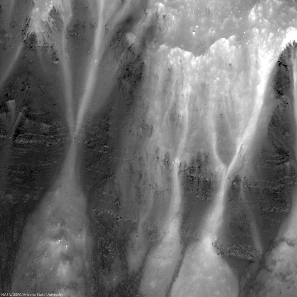
Bright talus winds downslope through crags and crannies in the banded scarps exposed in the east wall of Dionysius crater. Horizontal lineations result from differential mass wasting of stratified rock in Mare Tranquillitatis; High (35.12°) incidence Narrow Angle Camera (NAC) mosaic, from both left and right frames, from LROC observation M137434784, orbit 5387, August 26, 2010; east is up in this 450 meter field of view, 49 cm per pixel resolution [NASA/GSFC/Arizona State University].
J. Stopar
LROC News System

Dionysius crater (2.766°N, 17.297°E) is situated on the western edge of Mare Tranquillitatis (the Sea of Tranquility) and excavates both highlands (bright, high reflectance) and mare (dark, low reflectance) materials. Dark banded layers of mare peek out of the eastern wall, where mare material was disturbed by the impact that formed Dionysius crater. Bright talus trails wind downslope through crags and crannies in the dark mare scarps.

Looking closely, the mare appears banded or striated, indicating a non-uniform material. In general, mare are thought to form from large volumes of fluid lavas, much like the Columbia River Basalts in the Pacific Northwest of North America. The stratifications in the lunar mare may represent a series of lava flows in the region.

Blocky overhangs indicate areas more resistant to mass wasting and are interpreted as more coherent basaltic (mare) materials. The thinner, more finely grained layers might represent boundaries between individual lava flows or they may indicate changes in physical properties within a single flow unit. Some of the fine grained layers may even consist of paleoregoliths, ancient regolith surfaces exposed to the vacuum of space in between volcanic eruptions.

LRO Wide Angle Camera (WAC) mosaic of Dionysius and vicinity at local sunrise (featured area, on east wall, remains in deep shadow). Embedded on the southeast 'shore' of Mare Tranquillitatis, the high angle illumination on the surface during this observation opportunity revealed local topography over material brightness, though dark rays, beyond the bright ejecta blanket, can already be seen superpositioned on higher elevations to the west and much lower elevations to the east. 604 nm wavelength view stitched from observations during three sequential orbital passes December 13, 2010; resolution ~60 meters per pixel from 44 km [NASA/GSFC/Arizona State University].
In any case, craters such as Dionysius provide windows into the subsurface structure of the lunar mare. With further study, the total thickness of the mare, as well as the structure and flow mechanics of individual mare flows may be intuited from this and other mare exposures in the walls of impact craters.

Explore the full NAC image, HERE.

Visit these other craters with layered mare exposures:
Lava Flows Exposed in Bessel Crater
Layering in Messier A
Layering in Euler Crater
Layers in Lucian Crater
Marius A
Galilaei's Layered Wall
Dawes
Dionysius Detour

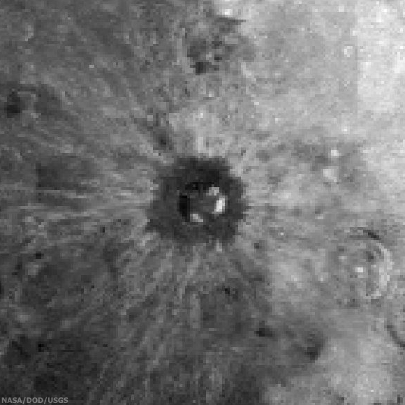
Roughly 150 x 150 km sample of the lunar surface captured from the 1994 Clementine mission. Centered on Dionysius, the data is filtered for Iron Oxide (FeO), a bright constituent of the Mare Tranquillitatis southwest and considered an indication of titanium and a reliable proxy for helium-3, shows how the relatively recent impact that created Dionysius excavated and mixed the sea boundary highlands to the west and ancient basalt plain to the east. Both bright and dark materials radiate more than 100 km from the crater center and beyond the dark ejecta blanket, darker here (though bright in radar and optical data), that dark doughnut is likely a 'false negative' resulting from the spacecraft's low resolution, at this wavelength, of small and fine blocky materials. The bright talus of exposed and very ancient mare basalt layers sifting down the craters walls (particularly on the east) is prominent however, matching the the spectral data of the basin on the east. (Note how older craters, gardened by longer exposure to space weathering, are far more faded into the background [NASA/DOD/USGS].

Wednesday, September 11, 2013

Bright and Dark Ejecta

LROC Featured Image, September 10, 2013 (M139782204LE)
A relatively recent impact event distributed bright, reflective ejecta across the lunar surface in southeast Mare Tranquillitatis. Smaller craters punch through the ejecta to reveal darker substrate, a contrast easier to see under a high Sun, and thus a lower illumination angle of incidence. A 500 meter-wide field of view from LROC Narrow Angle Camera (NAC) observation M139782204LE, spacecraft orbit 5733, September 22, 2010; a 10.11° angle of incidence, resolution 49 cm per pixel from 44.54 km over 4.37°N, 19.29°E [NASA/GSFC/Arizona State University].
Drew Enns
LROC New System

Fresh (young) impacts on the Moon often display magnificent ejecta blankets (so called because they "blanket" the surrounding terrain). Ejecta is unevenly distributed, which gives rise to its interfingered appearance.

Since space weathering tends to lower the albedo of material on an airless planet, the relative brightness of this ejecta blanket speaks to the young age of the parent crater.

In this case, the parent crater is just to the south of the opening image, and can be seen in the context image.

M162181924L-NSJ-1110-58b92-2252x3572
The same small, relatively fresh crater at local sunrise, when shadows under a higher illumination angle of incidence exaggerate variations in topography over albedo. Even so, the brighter surface rays are as distinct as striations channeled into the terrain by the blast. An 1875 meter-wide field of view from LROC NAC frame M162181924L, LRO orbit 9035, June 8, 2011; 73.88° angle of incidence, resolution 0.83 meters per pixel from 39.7 km [NASA/GSFC/Arizona State University].
But what is providing the small circular patches of dark material? Were the patches formed as part of the impact that formed the ejecta blanket, or later? Was the material excavated from below the bright ejecta? Most likely secondary craters (late stage ejecta) from the initial impact, hit and dug up dark mare material (original surface) from below the thin ejecta blanket. Can we test this idea? How dark is dark? In a more precise sense - do the albedos of the small low reflectance spots match that of the surrounding mare?

LROCqm250-sabine-rittter-manners
LROC Wide Angle Camera (WAC) context for the LROC Featured Image released September 10, 2013, showing the field of view located at located at 4.408 N, 19.230 E (marked by the cross). Nearby linear depressions (one smaller, closer depression is visible in the preceding image) may have provided the darker substrate discussed [NASA/GSFC/Arizona State University].
Your eye could be fooled by all the changes in reflectance. The small dark patches have a higher albedo than the mare (0.07 vs 0.06), which would be consistent with mare material mixing with the brighter (0.09 to 0.11) ejecta blanket. This observation is consistent with the secondary crater interpretation (the underlying mare is mixed with a small amount of the bright immature ejecta). If the reflectance of the dark patches was lower than that of the mare, then something else would have to be at work.

Can you think of other explanations while browsing the full LROC NAC frame, HERE?

Related Posts:
Beautiful Ejecta Patterns
DMD Excavations
Symmetric Ejecta

Tuesday, July 23, 2013

Small-Scale Volcanism on the Lunar Mare

LROCWAC-small-shield-volcanism-1314
"Small Shield Volcanism on the Lunar Mare," (figure 1.) EPSC 2013-875 Plescia, Robinson & Joliff. Constructs in Mare Tranquillitatis. a: low-relief, low-slope with central crater; b "pancake-shaped"; c and d': hummocky, steep-sided , gc: ghost crater. LROC Wide Angle Camera high-angle incident mosaic, centered near 7.5°N, 37.5°E [NASA/GSFC/Arizona State University] .
Plescia, Robinson & Jolliff
Johns Hopkins APL
Arizona State University
Washington University of St. Louis


"Small shield volcanoes having low relief and gentle slopes are scattered across the lunar mare. These features represent the terminal phases of mare volcanism and are formed by short-duration, low-volume eruptions. Composition and eruption dynamics may have varied as the morphology and color of the shields vary. There appears to be regional correlations of morphometric properties indicating larger-scale organization of the eruptions.

"Data from LRO and other missions now provide the ability to characterize each dome in terms of areal extent, topography, morphology, and color properties in unprecedented detail allowing for an analysis of their origin.


"Here, a subset of the domes are interpreted to represent a volcanic style characterized by small volume eruptions that built low-relief constructs (Fig. 1). This style of volcanism has been termed plains volcanism [14] and is common in the Tharsis region."

Small Shield Volcanism on the Lunar Mare, European Planetary Science Conference 2013, Vol. 8, #875; J.B. Plescia, Johns Hopkins University Applied Science Laboratory; M.S. Robinson, Arizona State University; B. Jolliff, Washington University, St. Louis

M190351657L-NSJ-0503-6509x8978
Small-scale shield volcanic vent structure ("d." in WAC mosaic above) south of Rupes Cauchy in Mare Tranquillitatis, near 7.5°N, 37.5°E; Vent strongly presents features resembling those of the Ina structure. 6.2 km-wide field of view from LROC NAC mosaic M190351657LR, LRO orbit 13098, April 29, 2012; 41.95° angle of incidence, resolution 0.95 meters per pixel from 113.33 km. Full-size versions HERE [NASA/GSFC/Arizona State University].

Thursday, April 25, 2013

The Monadnocks of Sinus Honoris

A northwest-southwest oriented groove between two inselbergs in Sinus Honoris (12.276°S; 18.712°E), an embayment near the northwest extreme of Mare Tranquillitatis. LROC Narrow Angle Camere (NAC) frame M181944849L, LRO orbit 11796, January 12, 2012. Illumination angle of incidence 67.94°from the west, field of view roughly 5.8 km across, resolution in the original 1.21 meters per pixel from 122.13  km [NASA/GSFC/Arizona State University].
James Ashley
LROC News System

Most of the physical sciences are instructive in the art of piecing together observations made at vastly different scales. Note, for example, how climatologists look at pollen in soil samples to assess climate change through time on a global scale. Geologists use microscopes to examine mm-scale crystals in order to understand magma chambers many cubic miles in volume.

Astronomers attempt to make sense of subatomic particles in the context of the entire visible Universe. With this in mind, try to explain the sculpted mountains in today's Featured Image, located at the northwestern margin of Mare Tranquillitatis.

Field of view shown at high-resolution in the LROC Featured Image released April 25, 2013 is outlined in yellow in this Wide Angle Camera (WAC) monochrome (566 nm) observation M165726769C, swept up in orbit 9557, July 19, 2011. Field of view 45.8 km, resolution 58 meters per pixel from 40.97 km [NASA/GSFC/Arizona State University].
You may find that adjusting the scale is necessary. Indeed; we will have to zoom out until we can see a good deal of the lunar nearside before the features have the context they need to be understood. (Examine the image above and below to pull back for increasingly smaller-scale, wider-field of view LROC WAC context images.)

A mosaic of the LROC WAC image immediately above, stitched together to observations of the same latitude from one orbit prior and after, July 19, 2011. Field of view roughly 145 km [NASA/GSFC/Arizona State University].
The WAC mosaic context image released with the LROC NAC Featured Image covers a more familiar 1,500 km wide field of view (one that happens also to include four of six successful Apollo landing sites; Apollo 11, 15, 16 and 17) [NASA/GSFC/Arizona State University].
These mountains are members of a group of mare-surrounded highland structures nestled between Mare Tranquillitatis and Mare Serenitatis. Examination of the region will quickly reveal a strong northwest to southeast trending orientation to most of the upland features that points directly back to the Apennine Mountains, which form the southeastern rim of the Imbrium basin. Now we can see that this whole region was sculpted by ground-hugging forces unleashed in the terrible cataclysm that formed that basin. Imagine witnessing this awesome event from the Earth over 3 billion years ago; it would have been clearly visible to the unaided eye!

Isolated mountains like these, which rise from a surrounding plain, are often referred to by geologists as monadnocks or inselbergs ("island mountains," or "sky islands"). On Earth such features might be erosional remnants, but here in the Bay of Honor (Sinus Honoris) we know them to be isolated by surrounding mare deposits.

Click HERE to see the full NAC frame. Additional examples of large-scale features on the Moon can be explored with Four of a Kind in Catena Davy, Nearside Spectacular!, and A Scar in the Highlands.

Tuesday, April 2, 2013

Melt or Rubble in Carrel Crater?

Debris pile at the bottom of north wall of Carrel crater (downslope toward bottom). Image center near 10.846°N, 26.653°E, field of view 500 meters, incidence angle is about 69° LROC Narrow Angle Camera (NAC) observation M177460712L, spacecraft orbit 11288, December 2, 2011; native resolution 47 cm per pixel from 38.78 km [NASA/GSFC/Arizona State University].
Hiroyuki Sato
LROC News System

Carrel crater (15.6 km in diameter) is located near the center of Mare Tranquillitatis.

On the north wall of this crater you can find several eye-catching flow features, starting from near the top of the wall, merged together on the way down to the bottom and finally deposited in a local topographic depression.

 The opening image highlights the infilled depression.

Is this fill composed of solidified impact melt, or simply a granular flow that originated by a slope failure? Which do you think?

The 4640 meter full width of the left and right frames of LROC NAC M177460712, from the newly-revised LROC QuickMap, zeroed in on Carrel crater. The feature highlighted in above and another, similar phenomena are designated with arrows [NASA/GSFC/Arizona State University].
The large incidence angle (69°, measured from vertical) of this image shows distinct relief of these flow features. The materials dumped in the depression show a flat surface where half is covered by gravel or rubble. The shadows along the left edge of this deposit give depth and imply a certain thickness, and no cracks or ridges are recognizable on the deposit surface. Typically impact melt flows exhibit viscous flow features (e.g. round distal edges, pressure ridges and levees as seen in Necho Crater, Channels And Fractures, Lichtenberg B Flow) and surface cracks. Not all these features are found in today's Featured Image.

Carrel crater and vicinity in LROC Wide Angle Camera (WAC) monochrome mosaic (100 m/pix), centered near 10.65°N, 26.71°E. The locations of full NAC frame (blue box) and the featured highlighted in the LROC Featured Image, released April 2, 2013 (yellow arrow) are shown [NASA/GSFC/Arizona State University].
Granular flows normally spread out in the final deposit, making thin distal edges as seen in Detour!, Debris Flows in Kepler Crater, Pytheas. But like these examples (Granular Flow, Outside of Giordano Bruno, How Recent?), sometimes they form thick round shapes or have levees along the flow path.

Carrel, a landmark crater of a First Quarter Moon, almost exactly between the landing site of Apollo 11, northwest of Moltke at bottom center and Apollo 17 in Taurus Littrow valley, just west of top center. Astronominsk April 21, 2010.
Those are rather similar to the features observed in the opening image, implying that these flows and the deposit might be formed by granular flows, but it is not easy to conclude due to its enigmatic shape. 

Explore these beautiful and enigmatic flow features in full NAC frame yourself, HERE.

Related Posts:
Debris Flows in Kepler Crater
How Recent?
Meandering
Pytheas
Detour!
Outside of Giordano Bruno
Dichotomy
Dry debris or liquid flow?
Granular Flow
Rock avalanche in Robinson crater

Thursday, March 28, 2013

New Views of the Hollows of Rimae Sosigenes

The Rimae Sosigenes region of northwest Mare Tranquillitatis, from a mosaic of newly released LROC Narrow Angle Camera (NAC) oblique (slew -55°) observations M1108117962LR captured in orbit 15584, November 12, 2012. The field of view is roughly 43 km from west to east (left to right) and scaled up considerably from an original 2.5 meter resolution, imaged from 146 km distance (114.87 km over 8.63°N, 24.9°E, angle of incidence 70.37°).   The largest crater above, Sosigenes A at lower left, is 11.3 km in diameter [NASA/GSFC/Arizona State University].
Joel Raupe
Lunar Pioneer

Running behind this holiday week, we're still busy digging through the latest, 13th batch of Lunar Reconnaissance Orbiter (LRO) data uplinked to the Planetary Data System (PDS) last week. The latest 90 day batch covers September 15 - December 15, 2012, and we're still hopscotching through it like a bee in a springtime garden.

But I wanted to take a moment to talk about hollows. The subject came up at the just-completed 44th Lunar and Planetary Science Conference, last week, in formal discussions about hollows on Mars and Mercury, and that fact reminded me it's been almost exactly a year since the fascinating topic of "meniscus hollows" on the Moon was discussed here.

A new LROC NAC observation of the Rimae Sosigenes area, captured last November, stood out among the few newly-released side-glance, or "oblique," NAC footprints in the latest LROC PDS batch, providing a new perspective on lunar hollows that did not come up in the conversation last year.

Phil Stooke of Western Ontario University collected an excellent inventory of these apparent remnants of gaseous blow-outs and presented it to the 43rd LPSC, last year. He's come up with the designation 'meniscus hollows," as fine description as may be. Among those in his catalog is "No. 8," on the "floor of a depression." 

The new oblique LROC NAC observation assembled at the head of this post shows us how deep that depression really is. Like a necklace encircling the floor of that depression (which resembles a vent, as seen elsewhere on the Moon) where it joins the wall.

A closer look at what was once thought to be a 'chain of craterlets,' a minor catena, slicing perpendicularly through one of a system of parallel north to south rilles - likely faults, that run from Maclear to Sosigenes A. Closer examination in more recent surveys by the LROC Narrow Angle Camera seem to show this structure to be a vent, perhaps related to the faulting. The above is medium resolution sample from  LROC NAC  M1108117962LR [NASA/GSFC/Arizona State University].
Elsewhere we've seen these hollows as hints of relatively recent geological activity, on ancient plains or on small extrusive domes - yet here we seem to see hollows placed in context with a visible complexity of formations with which they may be related. Perhaps some of the other hollows, like those situated alone on the Tranquillitatis plains south of Ross crater and east of Sosigenes, north of Arago and its domes, are all related to conditions under the surface that will turn out at least as complex. 

We don't know enough about Mare Tranquillitatis. It's not clearly an impact basin, like Imbrium and neighboring Serenitatis. It should be interesting to eventually examine the finer detail of these formations in the deeper granularity of the GRAIL mission data.

At Sosigenes faults run south to north parallel with the northwest edge of the mare. Classified as linear rilles, a kilometer or more wide, one is bisected perpendicularly by an 18 km long "gash," hinting at the collapse or shifting under the surface. It is probably immensely old, though at some point the floor of the depression may have been intruded upon from below, perhaps by gases venting at what may have been a weak zone, where the steep 380 meter walls of the depression meet the floor.

In depressed zones east and west of the central "depression of interest," the contact zone joining wall and floor has been blurred by mass wasting. Perhaps in the central depression, however, the distinction was made by material being blown out around the central floor. If so, it's not readily apparent around the outer edge of the formation (which is not the same as saying it isn't there.) Where did it go?

This 580 by 800 pixel sample of the full resolution mosaic (LROC NAC M1108117962LR) shows the 380 meter depths of the elongated formation is punctuated by 'meniscus hollows' very similar to others found just to the east, at the surface of Mare Tranquillitatis south of Ross crater, and more famously at the Ina structure, much further west. Perhaps they most resemble 'hollows' on the floor of the central depression of Rima Hyginus. Found here at the contact zone between the structure's floor and walls, the primary surface seems characterized by a low crater count. Are these hollows points where gases have explosively uncovered the structure's original floor?  [NASA/GSFC/Arizona State University].
 Closer still, in the full-resolution close-up above, something stands out, much as it does at that most famous of the 'meniscus hollows,' Ina. You can make your own comparisons with another new LROC NAC oblique mosaic detailed further below.

In short, the material covering the central depression's floor at its interior, away from the encircling hollows, doesn't appear to share the saturation cratering superpositioned upon it that is more characteristic of the surrounding plain. In fact, like the beaded "frozen liquid' appearance of the material at Ina, it looks relatively new.

A look more or less straight down (and at much higher resolution) at the eastern interior of the 380 meter deep central depression, at its walls together with a small part of the surrounding Rimae Sosigenes plain. Under higher illumination angles the depths of the topography defies our intuition. It doesn't look as deep as it in the oblique view further above, illustrating once again how relief seems to disappear on the Moon in the absence of shadows. From earlier LROC NAC observation M152750200LR, orbit 7645, February 19, 2011; resampled from 0.47 cm per pixel resolution  - angle of incidence 35° - from 39.56 km [NASA/GSFC/Arizona State University].
And an even closer look at one of the hollows along the contact between floor and the steep walls of the central depression at Rimae Sosigenes. Small boulders - apparently - shed from the wall  (and a slope of collapsed talus is piled at right (easier to see in the oblique view above). This field of view, 335 meters wide, comes from LROC NAC observation M177508146LE, LRO orbit 11295, December 2, 2011; angle of incidence 69.92° (slew -14.8°) resolution 0.48 cm per pixel from 37.86 km [NASA/GSFC/Arizona State University].
Optical maturity is no help here, hinting that the newest material is either more than a billion years old or does not result from the kind of kinetic energies released by cratering. In the image above, at bottom center, runs another contact line between the slope of "older" debris from collapsed walls at bottom right and the "newer" material "beaded" at the depression's center.

Is there a difference in the crater count? The material on the slope at bottom right seems darker, but that is likely an illusion from shadow and the elephant skin on nearly every lunar sloped terrain. It hardly counts as a control sample for counting craters and their size and erosion, etc., but no obvious difference in ages stands out between the two zones - nor are there any boulders or trails on either patch of ground. Those seem almost exclusive to the interior of the "blown out" hollows.

Perhaps the best large scale comparison with the meniscus hollows of the Sosigenes depressions is the endlessly compelling Ina formation of Lacus Felicitatis. And that's as good a segue as any to another newly-released LROC NAC oblique observation of that much studied and barely understood feature just below.

A fresh LROC NAC oblique view the Ina formation and its surroundings, a challenge for telescopes on Earth. A closer look at this mosaic's rendition of Ina's distinctive "D" is shown immediately below. Note the apparent rising cone of Mount Agnes, to Ina's northwest. This mosaic is assembled from LROC NAC M1108203502LR, exposing a field of view also roughly 43 km across, with both spacecraft and camera slewed -53°), looking west from 127.29 km over 18.77°N, 11.64°E, Sulpicius Gallus and southern Mare Serenitatis were directly below LRO, outside this side-looking view [NASA/GSFC/Arizona State University].
Perhaps it's a toss-up whether Ina or the hollows on the floor of the central depression of Rima Hyginus more closely resemble the hollows at Rimae Sosigenes. Perhaps the latter is something in-between. 

The view of Ina at an oblique angle, above and below, captured more than 140 km away from the LROC cameras, is not our most detailed look at that formation. Some unscaled examples of the very closest views of Ina surfaced with the LROC PDS release in December 2011. There doesn't seem to be much in the way of a depression resulting from the forces that created Ina, though the beaded remnants or surfacing seems to closely resemble the floor of the Rimae Sosigenes depression.

A new angle on the Ina (3 km across, 18.65°N, 5.3°E) from the immediately preceding mosaic sampled at its full 2.6 meter per pixel resolution [NASA/GSFC/Arizona State University].
Over the next decade or so, when researchers have time to weave together data collected by LROC, Mini-RF and from the GRAIL twins, a better picture of these 'meniscus hollows' will likely emerge. In the end, the formations themselves may turn out to be the surface manifestation of something deeper that we can hardly imagine today.

Related Posts:
Inside Rima Hyginus (June 12, 2012)
Whale of a Hollow (March 20, 2012)
Ina of the Meniscus Hollows (March 21, 2012)
The closest of lunar close-ups (December 16, 2011)
It's a gas, man (October 8, 2011)
Spectral Properties of Ina (February 7, 2011)

Thursday, January 3, 2013

Up and Down, Back and Forth

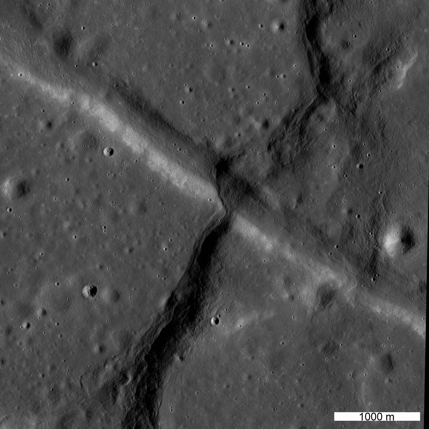
Compression and extension in Mare Tranquillitatis. A northeast-trending wrinkle ridge has overridden a northwest-trending graben. LROC Narrow Angle Camera (NAC) image M192774961L, LRO spacecraft orbit 13437, May 27, 2012; angle of incidence 69.44° at 0.96 meters resolution from 115.91 km [NASA/GSFC/Arizona State University].
Jeffrey Plescia
LROC News System

Today's Featured Image shows the amazing intersection of a northeast-trending wrinkle ridge and a northwest-trending graben, both found in Mare Tranquillitatis (intersection is located at 9.2°N, 27.66°E).

This juxtaposition of structures indicates that the area was extended in a NE-SW direction pulling the surface apart and forming the graben. Later, it was compressed along a NW-SE direction pushing the surface together and forming the wrinkle ridge.

Structural stresses in the crust are not always simple! Another large scale example of this type of intersecting compression and extension environments exists in eastern Mare Tranquillitatis at Cauchy rupes and rimae.

Larger view of the area in the Featured Image. The wrinkle ridge extends to the northeast and southwest changing morphology from narrow to wide. Sun is coming from the east (right). LROC NAC image M192774961L [NASA/GSFC/Arizona State University].
The width of the ridge varies from about 700 m to more than 2500 m, it is about 120-150 m high adjacent to the graben. Large variation in the width of wrinkle ridges is common.  In this case, the thrust fault that formed the ridge is interpreted to dip to the southeast, based on the asymmetry of the topography (the northwest side of the ridge has a steep slope and the southeast side has a gentle slope).

The lunar surface exhibits a variety of tectonic features that are produced when the stresses in the crust exceed the strength of the rock and the rocks break.  Depending upon the magnitude of the stress, the strength of the rock, and the orientation of the stress different types of tectonic features are produced. The two most common on the Moon are graben and wrinkle ridges. Graben are narrow blocks of the crust that have been down-dropped between two normal faults. Wrinkle ridges are thrust faults in which a part of the shallow crust has been thrust over the adjacent area; the upper part of the crust has been folded like an anticline into the wrinkle.

LROC Wide Angle Camera context, the graben -wrinkle ridge intersection below left center in a composite of three sequential orbital WAC observations collected December 12, 2010 (orbits 6767-6769), averaging 73° angle of incidence, 62 meters per pixel resolution from 45 km [NASA/GSFC/Arizona State University].
In this particular location the type of stress reversed over time. First there was an northeast-southwest directed extension that produced the graben, which is about 500-700 m wide and extends for more than 50 km to the northwest. Later, the crust was compressed along a northwest-southeast direction that resulted in the wrinkle ridge.  This ridge is part of a system of wrinkle ridges that extend southwest from a ridge of exposed older highlands material ~30 km to the northeast.

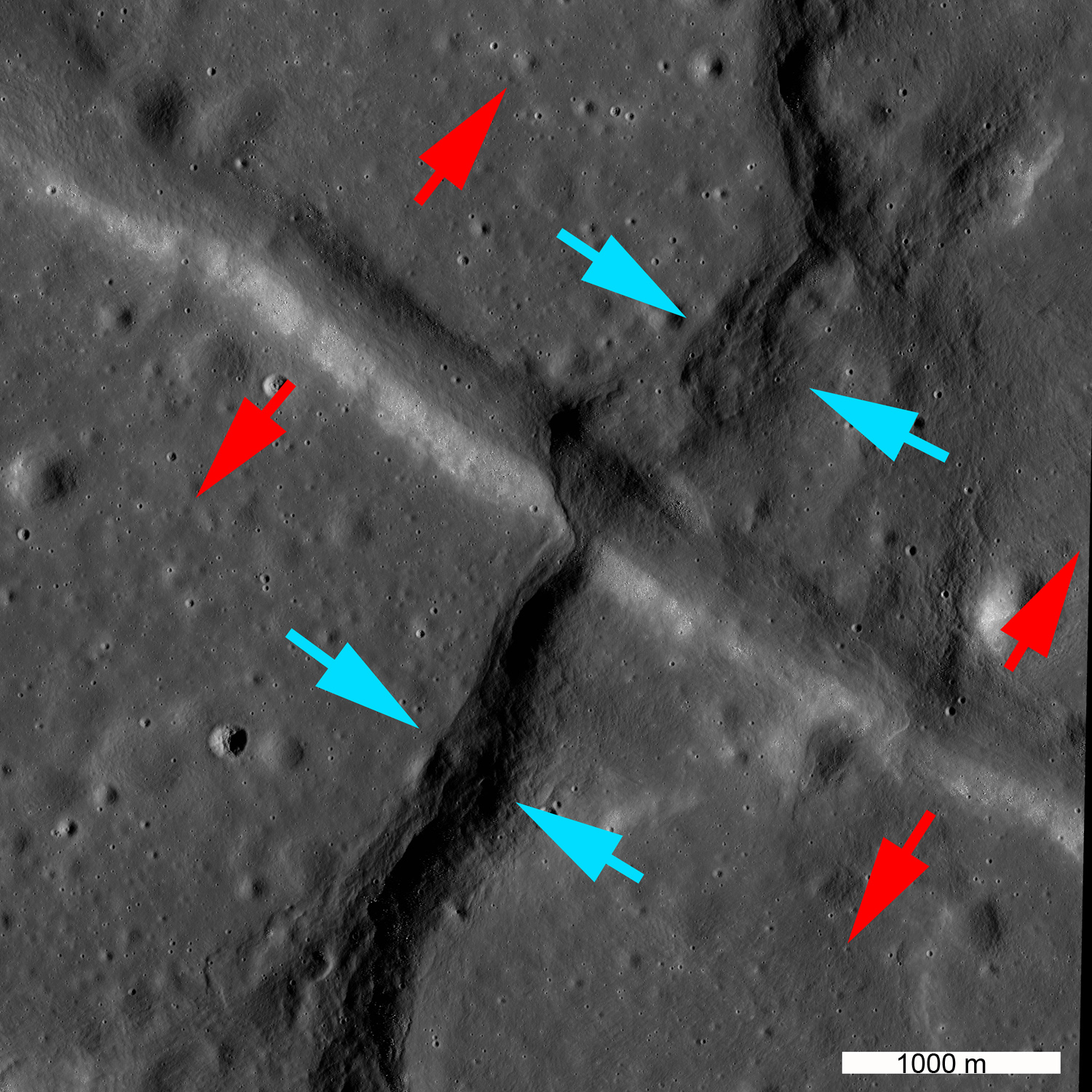
The annotated image below shows the stress directions associated with the graben and the wrinkle ridge.  Red arrows denote the tensional stresses that produced the graben; blue arrows denote the compressional stresses that resulted in the formation of the wrinkle ridge. What happened to cause this reversal, and when did it happen?

Blue arrows denote direction of compression producing the wrinkle ridge; red arrows denote direction of extension producing the graben [NASA/GSFC/Arizona State University].
Explore the entire tectonic feature in the full LROC NAC image, HERE.

Related LROC Featured Images:
Watch That First Step!
Tectonics in Mare Frigoris
Pull Apart - Grabens
It's the Moon's Fault
Linear Graben

Tuesday, August 28, 2012

Armstrong crater

Armstrong crater, Sea of Tranquility - LROC Narrow Angle Camera mosaic of Armstrong, the appropriately unassuming 4.2 km-wide crater (before 1970, "Sabine E") 47.1 km northwest of Tranquility Base (or roughly 64 km north by northwest of the much easier to locate landmark crater Moltke) at 1.356°N, 24.941°E.  From a highly reduced combination of sampled lines from LROC NAC M126765005 (LRO orbit 3815, 47 cm resolution from 39.5 km altitude, April 24, 2010) and M172758358 (orbit 10593, 49 cm resolution from 42.6 km altitude, ), both under mid-day full illumination but many lunar days apart [NASA/GSFC/Arizona State University].
The image above does not do justice to the 16000 line by 10000 pixel montage needed to catch all of modest Armstrong crater at the highest resolution possible. Only two people ever had the opportunity to catch such a view, and they were very busy at that brief moment, absorbed with the raw novelty and challenge of arriving at the lunar surface

The information is stored in two standard double 5000 sample by 52224 line LRO NAC photographs now available in the Planetary Data System (PDS).

A new barely-born effort is underway to make the several life-times worth of PDS data more user-friendly. You can call this an experiment, an early part of that effort, and like most experiments it is a failure.

To illustrate that failure better, as an additional tease, below, at full resolution, and at the maximum 580 by 800 window allowable to users of this blog format, is a very small part of that wall-sized product, specifically the part of the Armstrong crater wall at roughly 5 o'clock (or 170° of arc) in the 'thumbnail' above featuring a unusually wide line of darker fine debris flow.

Sound principles of super-positioning seem to indicate Armstrong is an old crater on the main-sequence of lunar crater types, barely large enough to have once supported a floor, now long buried by steady mass wasting. It's a pounded, rounded and well-gardened interior and has none of the great boulders on the rim that would set it apart as relatively young. Still, the interplay of epochs that have etched their passing on the Tranquillitatis basin (if it is a true impact basin) is at least as delightful as clouds in a spring day sky. LROC NAC M126765005L [NASA/GSFC/Arizona State University].

Without the jagged features characteristic of younger similarly-sized craters, craters like South Ray, not yet baked evenly into reddened optical maturity, even the highest resolution segment of the mosaic doesn't invite anyone to go through a similar time-consuming process of creating a wall-sized picture of Armstrong crater. Flight planners did not choose this place on the Moon for its drama.

Site B was selected for the first landing so that first pilot would not have to take control from an over-loaded on-board computer to dodge boulders looming up from the spot where the delicate Lunar Module was trying to land.

The dark-line and notch at "5 o'clock" on the rim of Armstrong (inset at original resolution) is more than a superficial darker debris flow, after all. The relief at angles of illumination unavailable at high-resolution definitely show a notch in the crater rim anatomy, at 60 meters resolution. There is also a stream of secondary cratering that amounts to a ray, perhaps from Theophilus. The white arrow is the landing site of Apollo 11. LROC Wide Angle Camera mosaic (604nm) from several orbital passes July 2011 [NASA/GSFC/Arizona State University].
Fortunately, the relatively small crater is not terribly difficult to spot using a modest telescope, if, in addition, an Earth-bound observer has more than a passing knowledge of the Moon's nearside in general and the Sea of Tranquility in particular.

Bit by slow bit we are gathering information that adds up to a fairly accurate simulation of the Moon, but to experience a truly accurate picture of our own back yard we are also having confirmed what we already knew.
You really have to have been there.

From a 33 percent reduction of a truly spectacular color mosaic of the Moon captured by the "miracle boys of Minsk," Astronominsk, April 6, 2009.