Showing posts with label Schrödinger. Show all posts

Tuesday, March 25, 2014

Young Crater Walls (at the Schrödinger Antipode)

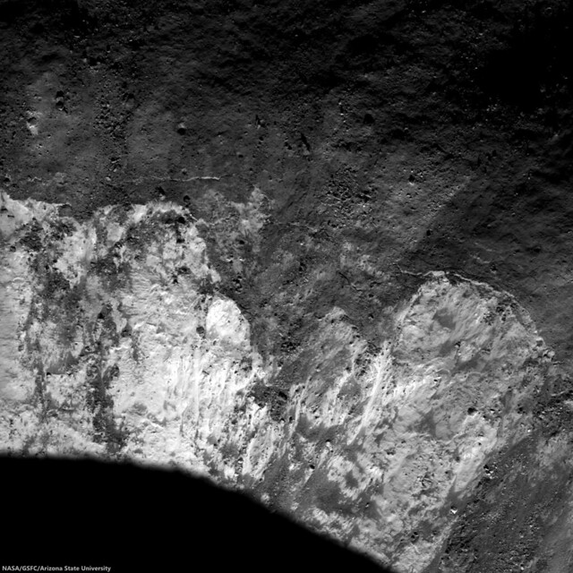
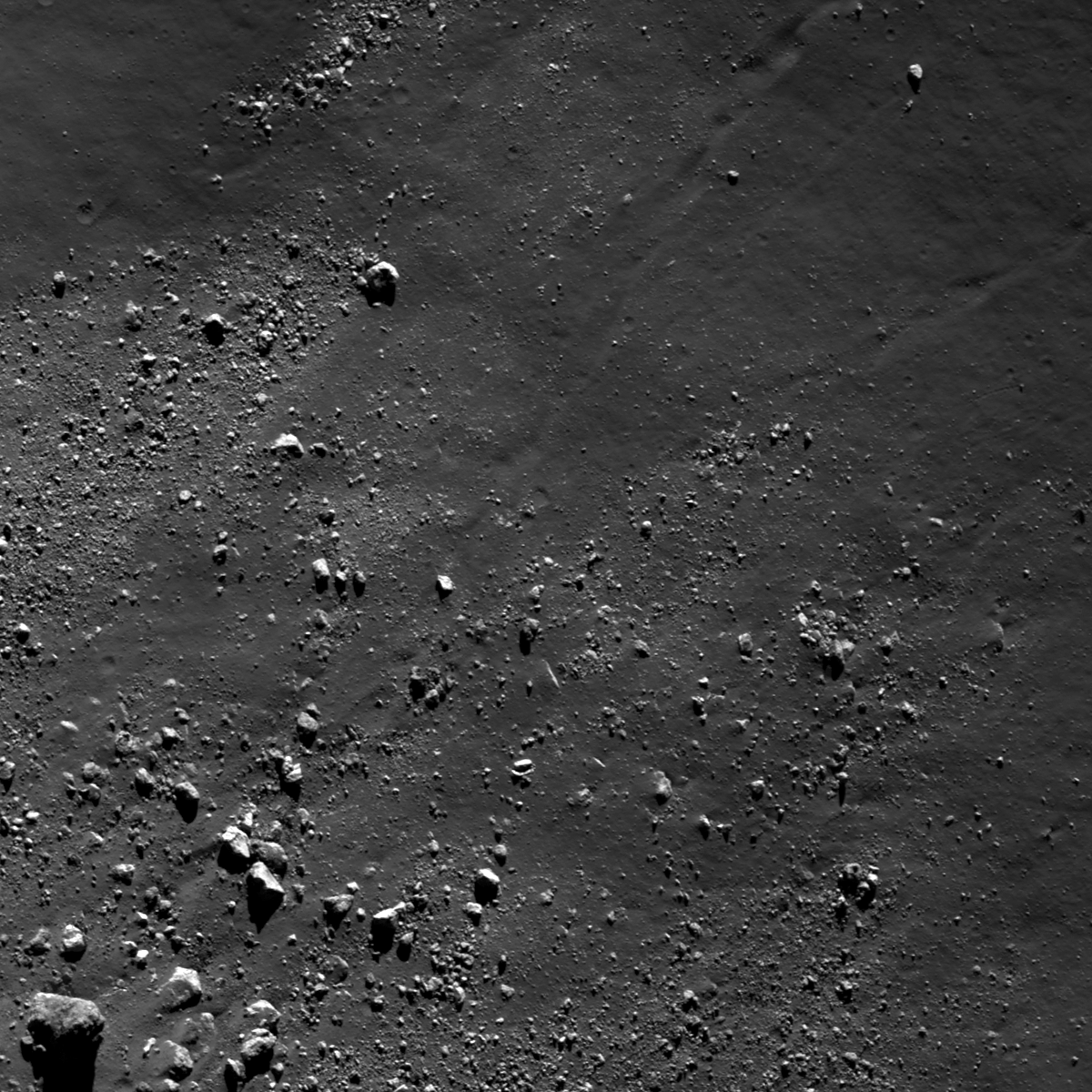
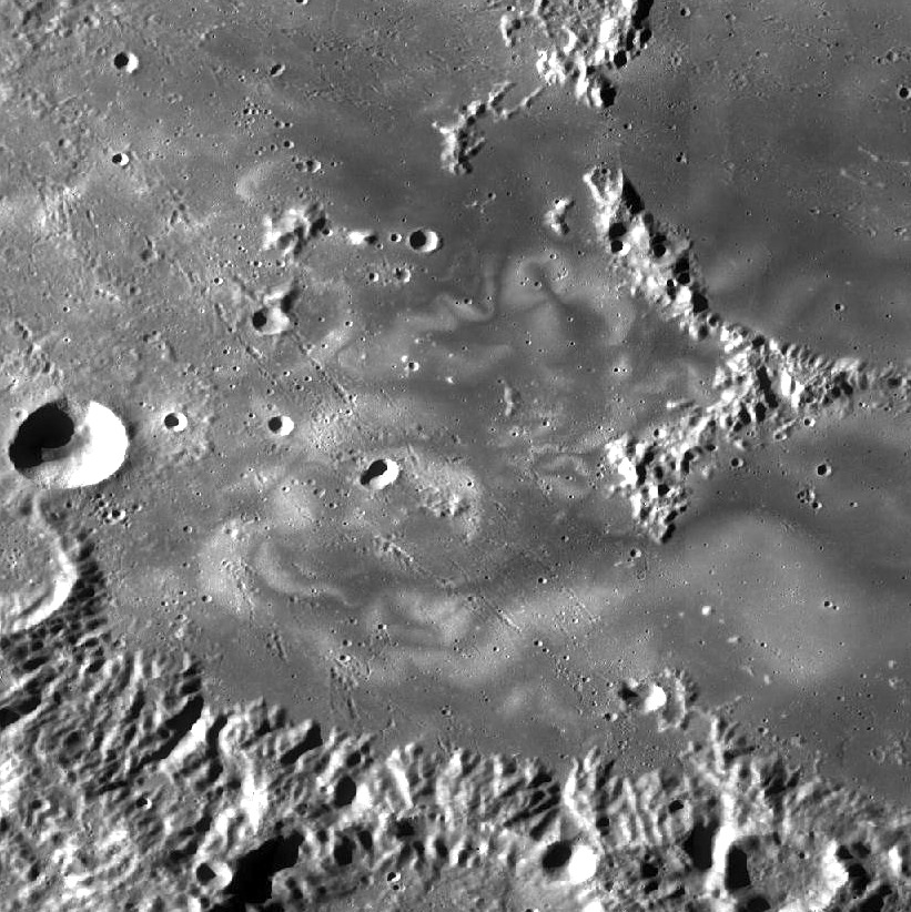
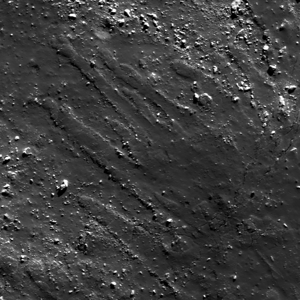
Northern rim of an unnamed young crater near 80°N, 278.9°E, north of Catena Sylvester, on the far north nearside and nested within crustal magnetism that may be related to the Moon's youngest impact basin (Schrödinger) on the direct opposite side of the Moon. 1243 meter-wide field of view, sampled from LROC Narrow Angle Camera observation M125130801R, LRO orbit 3574, April 5, 2010; 78.42° incidence, 1.09 meters resolution from 53 km [NASA/GSFC/Arizona State University].].
Hiroyuki Sato
LROC News System

After the unimaginably violent processes of excavation and ejecta emplacement, impact craters gradually change their shapes with time by various processes, such as the isostatic rebound, mass wasting, subsequent impacts, and space weathering.

Today's Featured Image highlights such a post-impact degradation process.

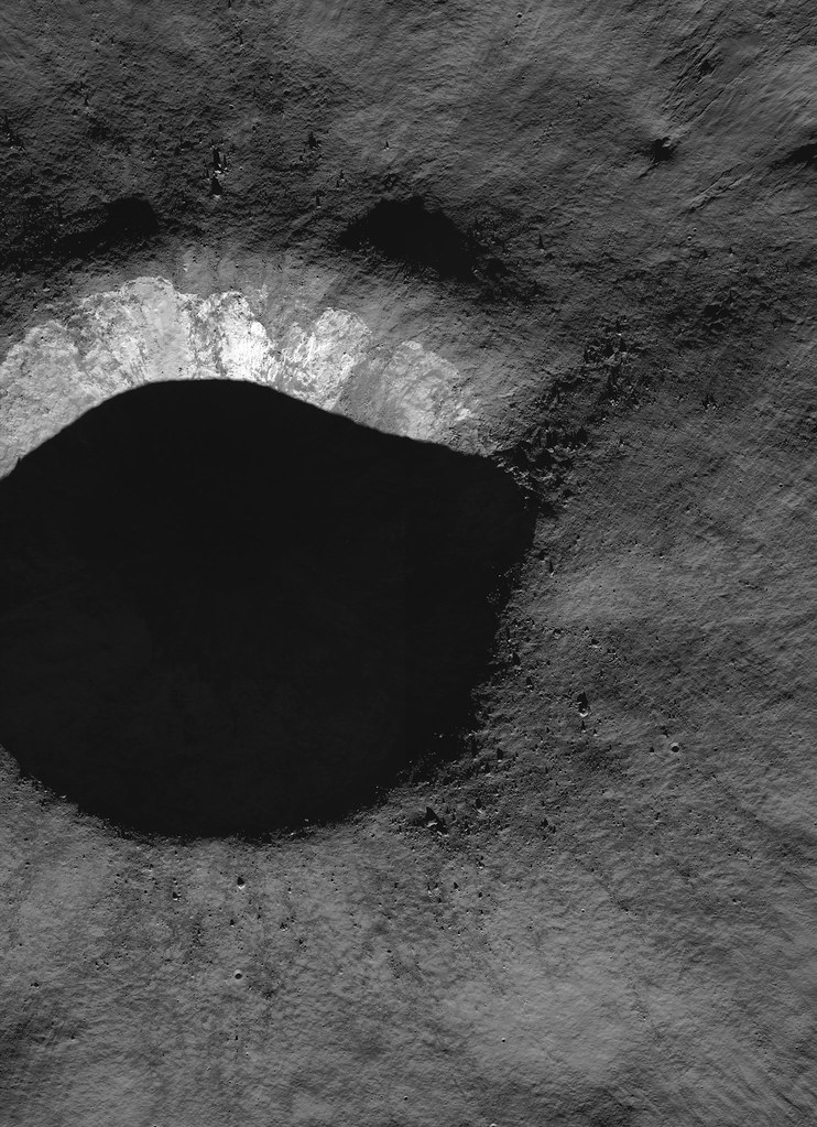
Full-width mosaic of the LROC NAC observation from orbit 3574. The full-sized (4581 x 6319) original can be viewed HERE. Though the high-angle of illumination at this high latitude favors outlines of topography over intrinsic brightness and color,  relatively darker and lighter materials radiate over great distances, aiding studies of how younger materials interact with anomalous local magnetism [NASA/GSFC/Arizona State University].
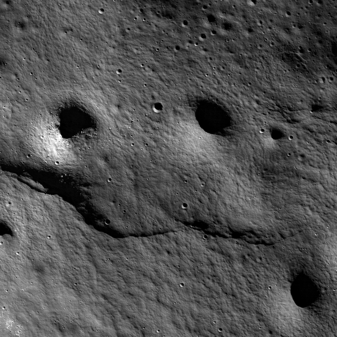
The lower half of this image (relatively high reflectance) is the crater wall, downslope is to the bottom. The bottom-left dark area is the shadow of southern crater rim. Upper half of the image with a low reflectance surface is the crater rim and the rim slope out of the cavity, mostly covered with impact melt. The low reflectance area at the image center just above the steep wall has multiple horizontal cracks showing where the hardened impact melt has cracked as the steep walls slowly fail and slide into the crater bit-by-bit. These slope failures continuously refresh the crater walls, removing the melt coatings and exposing subsurface materials.

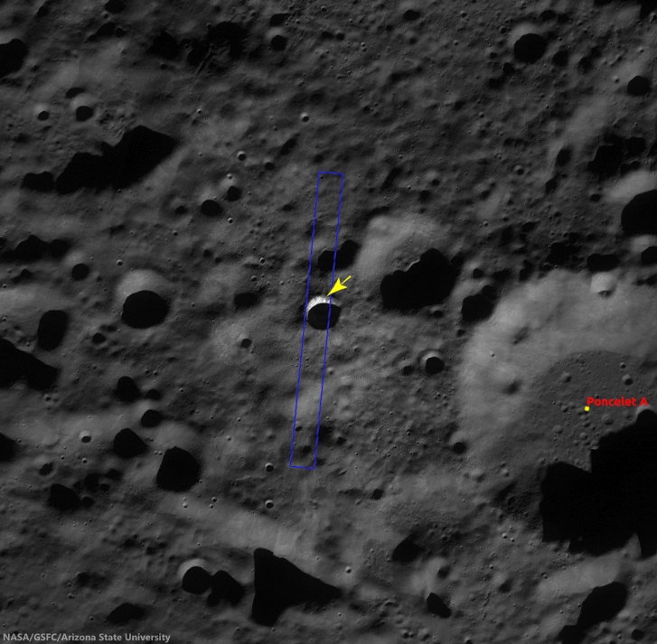
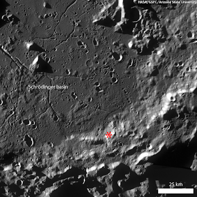
Context image of the unnamed crater and the surrounding area in LROC WAC monochrome mosaic (100 m/pix). Image center is 79.97°N, 278.87°E; image width is about 66 km. The NAC footprint and the location of the opening image are illustrated [NASA/GSFC/Arizona State University].
Most of the fresh craters that we observe have suffered these slides, leaving the commonly observed rootless melt flow features on the rim slopes. Just after the impact occurred, much of the crater interior was covered by impact melt, but these rock veneers are quickly removed from steep slopes leaving fresh outcrops of the target (regolith and, in the case of mare, bedrock).

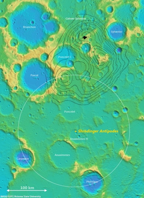
Arrow marks the young crater highlighted in the LROC Featured Image, released March 25, 2014, west of Poncelet C. The white circle is an approximate reflection of the parameters of the Schrödinger impact basin, the Moon's youngest, centered on a point on the diametrically opposite (antipodal) side of the Moon from the center of Schrödinger, in the far south. Grey lines outline nodes of anomalous crustal magnetism teased from Lunar Prospector (1998-99) data. Noted planetary scientists Lon Hood and Paul Spudis use the excavation caused by the smaller impact to aid in determining how local topography may have been disrupted, as they have suggested, by the force of the Schrödinger basin-forming impact. One challenge will be to determine how much the comparatively weak crustal magnetism interacts with migrating dust and fresh impact debris to create albedo swirl features [NASA/GSFC/Arizona State University]. 
Explore the resurfaced fresh crater walls in full NAC frame yourself, HERE.

Related Posts:
The Moon's antipodal magnetism mystery
Lunar swirl phenomena from LRO
Slope failure near Aratus crater
Sinuous Cracks
Slope Resurfacing
Stratified Ejecta Blocks
Dark Impact Melt Sheet
Thin Dark Layer

Wednesday, June 19, 2013

The Moon's antipodal magnetism mystery

A new study of areas on the Moon opposite (at the antipodes) of the Moon's youngest basins goes beyond long-studied crustal magnetic anomalies and the albedo "swirls" at those opposite coordinates to demonstrate "highly modified terrain" at these opposing points. Animation from preliminary lunar crust thickness maps derived from GRAIL (2012) data by the Science Visualization Studio. [NASA/GSFC].
Paul D. Spudis
The Once and Future Moon
Smithsonian Air & Space


Although the Moon has no global magnetic field like the Earth, small areas on its surface are magnetized.  These fields are not systematically distributed and in general are very weak.  In trying to explain their mysterious presence and origin, several ideas have been advanced.

Rocks typically acquire magnetism (called remnant magnetism) by cooling in the presence of a magnetic field.  At temperatures greater than about 570° C (the so-called Curie point), a rock cannot retain a magnetic signature.  But if it cools below the Curie point, it assumes an induced magnetic field oriented in the same direction as the field in which it cooled.  Unfortunately, on the Moon most rocks have been dislodged from their original orientations by impact processes, so we do not know whether a given rock cooled in the presence of a global (presumably uniform strength and direction) or local (randomized) magnetic field.

We knew the Moon had no global magnetic field before the Apollo crews landed, so it was a bit surprising to learn that some of the returned lunar rocks are strongly magnetized.  Because these rocks are all very old (usually much older than 3 billion years), it was thought that they recorded an ancient epoch when the Moon might have had a global magnetic field, now vanished for some reason.

This finding from the lunar samples was complemented by measurements from orbit that show small areas (10s to 100s of kilometers across) of the surface to be magnetized.  These areas occur all over the Moon and are not associated exclusively with either the dark volcanic maria or the bright highlands crust.  However, they do tend to have two peculiar properties.  First, we find strange “grooved” terrain associated with some of the strongest magnetic anomalies.  This terrain is unlike any other lunar landform – it consists of ridges and valleys that cover the walls and sides of craters and mountains.  Second, these magnetic anomalies tend to occur at the antipodes of (180° away on the opposite side of the globe from) the largest and youngest lunar multi-ring impact basins.  These are curious properties indeed.  What might it mean?

For years, many have pondered and worked on this dilemma.  One idea was developed that perhaps these magnetic anomalies are formed during basin impact.  It was proposed that seismic shaking from these enormous impacts created the grooved terrain and induced fractures in the crust at the antipode, into which hot volcanic magma was injected.  After cooling these dikes assumed remnant magnetism from a global dipole field.  Yet another idea contends that the concentration of magnetized material is a result of antipodal convergence of basin ejecta, which arrived hot from basin formation, collected at the antipode and cooled through the Curie point there.  This last model has the advantage that it might also explain the presence of the grooved terrain, which might have formed by the arrival of basin ejecta on the surface from impacts coming from all directions simultaneously.

Though islands of crustal magnetism are strongly associated with points diametrically opposite from basin forming impacts, these magnetic anomalies are also often offset from those antipodal points. Above, the ring of the Moon's youngest basin Schrödinger, in the far lunar south, is mirrored on the area on the direct opposite side of the Moon in the far lunar north. The absolute antipode is in the vicinity of Anaximenes H. The crustal magnetism mapped using Lunar Prospector data seems at its highest near Catena Sylvester. Terrain cited as greatly disrupted seismically is further still from the Schrödinger antipode, at craters Froelich and Lovelace, just beyond this field of view, at upper right [NASA/GSFC/ASU].
My colleague Lon Hood from the University of Arizona has been studying magnetic anomalies for many years and is an advocate of the last model described above.  Hood was studying some previously ignored, smaller magnetic anomalies found around the Moon that had no explanation. He asked me about the geological setting of one particular magnetic anomaly on the Moon that had yet to be described in detail.  This one occurs in highlands near the north pole of the Moon and had not been previously studied in detail.

I have been something of a skeptic for many years about the basin/antipode relation for magnetic anomalies.  Part of the reason for my position is the problem of Reiner Gamma, which is a bright patch on the lunar surface that has one of the highest magnetic field strengths on the Moon.  The problem is that Reiner Gamma is nowhere near the antipode of any basin and shows no evidence for any grooved terrain.  So I thought that this was the exception that disproves the rule.
“Will your grace command me any service to the world's end?  I will go on the slightest errand now, to the Antipodes that you can devise to send me on…”
- Much Ado About Nothing, (Act II, scene 2)

Nonetheless, I was intrigued by Hood’s finding and decided to examine the area.  To my astonishment, I found wall textures very similar to the famous grooved terrain in the walls of the craters Lovelace and Froelich (not exactly coincident with the anomaly, but very close).  I can see no obvious reason for such terrain development; it appears to be highly restricted in its distribution and is not a fresh feature.  Judging from its degraded appearance, it is rather old.

So, is there a basin antipodal to Lovelace and Froelich?  Indeed there is – the fabulous Schrödinger basin, one of the smaller lunar basins at 325 km diameter, located near the south pole of the Moon.  Before our study, I probably would have thought that Schrödinger was too small to create any global-scale effects, but we don’t fully understand the effects of impact with increasing size and there is no good alternative explanation for the wall textures of these two craters.  The presence of a significant magnetic anomaly nearby is unquestionable.

Froelich (l) and Lovelace (r), adjacent to Catena Sylvester (above map) and the region antipodal to Schrödinger basin - showing grooved terrain in walls (green arrows).
From Hood, et al (2013). Along with its spectacular lunar swirls and complex crustal magnetism, grooved terrain along the walls surrounding Mare Ingenii is also a easily identified characteristic of the region adjacent to the antipodes of Mare Imbrium. Less well-known, perhaps, is the region antipodal to Mare Serenitatis, along the north rim of the more ancient South Pole-Aitken basin [NASA/GSFC/ASU].
So have I changed my mind on the origin of lunar magnetic anomalies?  Possibly.  One of the most convincing ways to get a scientist to change his mind is to bludgeon him with an irrefutable fact that contradicts his worldview.  I now realize the Reiner Gamma problem does not “disprove” the basin antipode model – it merely indicates that it may be incomplete.  That distinction is subtle but significant.  In science, we always look for “rules,” generalities that help us organize observations and suggest possible explanations.  However, these rules sometimes have exceptions and we must carefully distinguish which actually have the force of a rule versus those that merely indicate some general tendencies.

To me, this discovery was surprising.  The new finding still does not fully address exactly how these magnetic anomalies are formed at the antipodes, but the concept that magnetic anomalies and basin-forming impacts are intimately associated has been strengthened and extended.  We will continue to work on this vexing problem.

Originally published June 19, 2013 at his Smithsonian Air & Space blog The Once and Future Moon, Dr. Spudis is a senior staff scientist at the Lunar and Planetary Institute. The opinions expressed are those of the author but are better informed than average.

Related Posts:
Bubble, Bubble – Swirl and Trouble (July 19, 2012)
Boulder 668 at Descartes C (July 16, 2012)
LROC: The Swirls of Mare Ingenii (June 22, 2012)
Remnant magnetism hints at once-active lunar core (January 27, 2012)
Grand lunar swirls yielding to LRO Mini-RF (October 4, 2010)
Another look at Reiner Gamma (June 30, 2010)
LOLA: Goddard (June 26, 2010)
Depths of Mare Ingenii (June 16, 2010)
LROC: Ingenii Swirls at Constellation Region of Interest (May 26, 2010)
Local topography and Reiner Gamma (May 22, 2010)
Lunar swirl phenomena from LRO (May 17, 2010)
The still-mysterious Descartes formation (May 11, 2010)
Dust transport and its importance in the origin of lunar swirls (February 21, 2010)
The Heart of Reiner Gamma (November 17, 2009)
Moon’s mini-magnetospheres are old news (November 16, 2009)
MIT claim of solving ‘lunar mystery’ unfounded (January 15, 2009)

Tuesday, May 7, 2013

Boulder Tails

Boulders greater than 1 meter across, and a few trails, surround the base of a mountain in the Schrödinger central peak ring. Boulder in lower left is around 55 meters across; mountain base is beyond the frame to the lower left. LROC Narrow Angle Camera (NAC) observation M187340587LR, image field of view 732 meters, resolution 0.77 meters per pixel, angle of incidence 79.15° from 36.56 km  [NASA/GSFC/Arizona State University].
Lillian Ostrach
LROC News System

The Schrödinger impact basin is a geologically fascinating location, especially because of the variety of geologic features available for future exploration and it is the second youngest large basin on the Moon (just behind Orientale).

Discussed at length in several other Featured Image posts, blocky material, including boulders greater than 1 meter in diameter, can be used to help unravel geologic stories for an area.

In the case of boulders in Schrödinger, often the boulders originate from regions not easily accessible by robotic equipment or humans. Today's Featured Image highlights a distribution of boulders near the base of a part of the central peak ring (77.196°S, 133.178°E).

Context for the LROC Featured Image released May 8, 2013 - LROC Wide Angle Camera (WAC) monochrome (604nm) mosaic from 15 orbital passes, just after LRO completed its 10,000th orbit, September 3, 2011. Field of view (see section from mosaic below) roughly 50 km across [NASA/GSFC/Arizona State University].
LROC WAC mosaic covering a quarter of Schrödinger basin, show the 1400 meter high mountains rising over the mare-flooded interior contiguous with the greater peak ring structure [NASA/GSFC/Arizona State University].
Displaced fragmented blocks, such as those observed in the opening image, represent the movement of material from higher elevation to lower elevation. Most of the boulders range in size from ~15 to 25 m across, although the boulder in the lower left of the opening image is about 55 m across.

Today's boulders are derived from the higher elevations of a massif that is part of the Schrödinger central peak ring. Why is this fact geologically interesting? Because central peak rings form during the impact process; as the target is deformed and displaced during impact, material from depth is pushed toward the surface. Central peaks are usually formed in complex craters with diameters ranging from roughly 15 km to 200 km, but when the impact crater is larger than 200 km, central peak rings begin to form.

So, boulders originating from a central peak or central peak ring sample rocks from far beneath the lunar surface. How far? Scientists are not exactly certain, but there are several hypotheses and models undergoing testing with the help of LROC data.

HDTV still image captured from Japan's lunar orbiter SELENE-1 (Kaguya) in 2008. This oblique view was imaged as the vehicle orbited north, up over the Moon's farside from the far south [JAXA/NHK/SELENE].
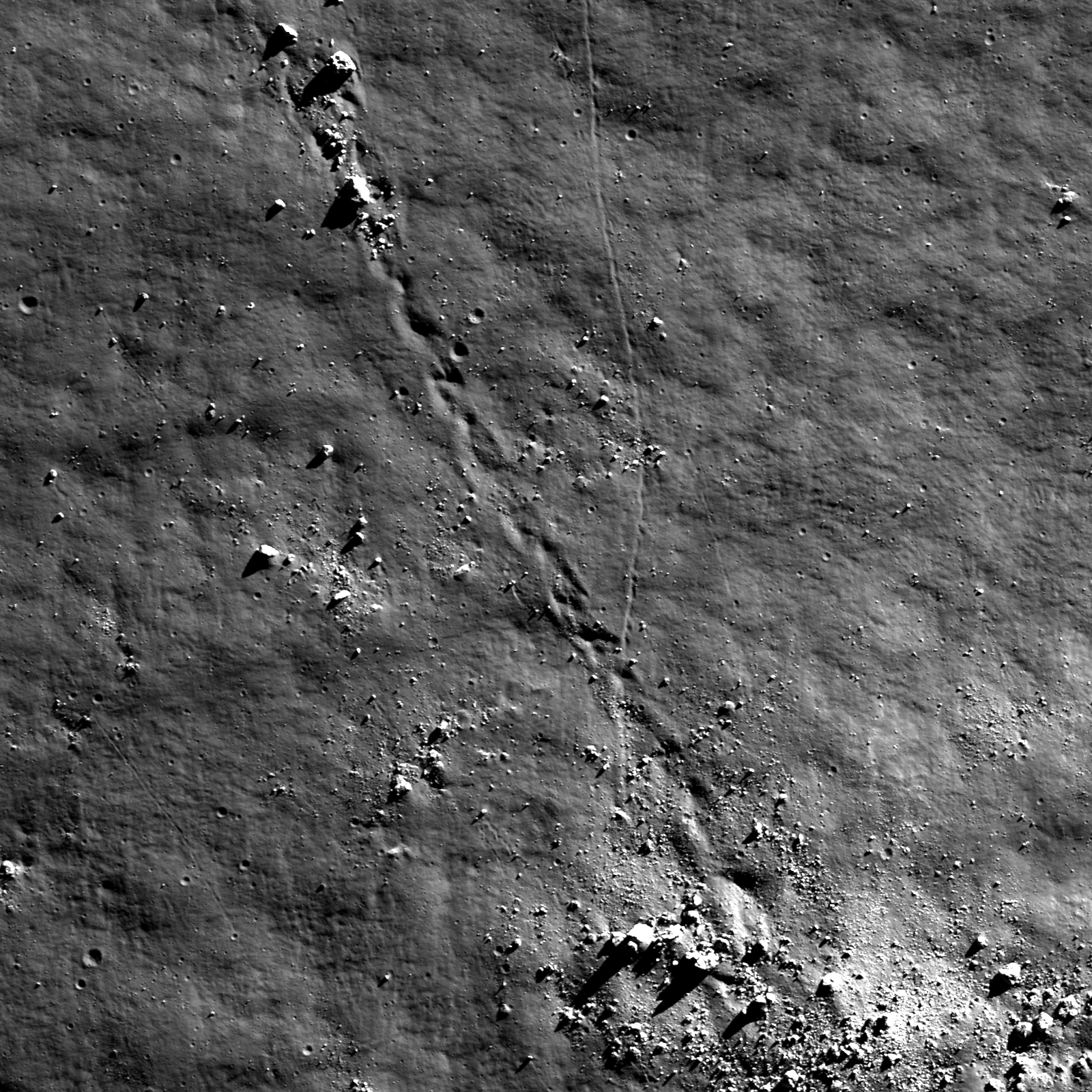
Looking carefully, there is a boulder trail present (diagonally from lower left to upper right), and the boulder trail width is ~25 m near the upper right of the image. The irregular shape of the trail suggests that the boulder responsible for the trail was probably irregularly shaped. Additionally, the boulder trail is not discontinuous or "dashed", so it may be that the boulder responsible for the trail had a relatively low velocity. Similarly, there may be local slope variations in this area that promoted boulder rolling as opposed to boulder skipping.

Can you find a boulder that may be responsible for creating the observed boulder trail in the full LROC NAC image, HERE?

Related Posts:
A review of all things Schrödinger  
Craters on the Schrödinger pyroclastic cone
New 3D CLSE flyover video: Schrödinger basin
Sampling Schrödinger
Sampling a Central Peak
Perched boulders
Scarps in Schrödinger
LOLA: Schrödinger Basin

Saturday, March 9, 2013

New 3D CLSE lunar flyover video: Schrödinger basin


David A. Kring, Ph.D.
Center for Lunar Science & Exploration (CLSE)


The Center for Lunar Science and Exploration added another video to its Atlas of Lunar Flyovers. In this new addition, we explore the floor of the Schrodinger basin.The direct link to the new flyover is HERE.

The Moon’s Schrödinger basin is the best preserved impact basin of its size.  Its broad flat floor offers several safe landing sites and the geology within the basin is extraordinary.  The two highest science priorities and over half of the science objectives outlined in the National Research Council (NRC) report The Scientific Context for Exploration of the Moon (2007) can be addressed with field studies and samples collected in Schrödinger basin.

Schrödinger basin CLSE landing study 'Site B' (yellow ellipse), well within the 10 km safety 'walk-back' distance of the an unnamed 6.8 km Copernican Age crater that presumably excavated deep into the basin's intact peak rings, depositing valuable samples near the crater rim. (Further details on this site will be the subject of a future post.) The site, in context with the larger basin, is marked with a yellow arrow below. LROC Wide Angle Camera (WAC) monochrome (643nm) observation M169698283C, LRO orbit 10142, September 3, 2011; angle of incidence 72.67° at 81.3 meters resolution, from 58.66 km [NASA/GSFC/Arizona State University].
The video highlights three features in the basin.  It begins with a flight along a fracture in the basin floor towards an immense volcanic vent of pyroclastic material.  Because of the in situ resource utilization (ISRU) potential of the pyroclastic material, this vent was a target of the Exploration Systems Mission Directorate (ESMD) portion of the Lunar Reconnaissance Orbiter (LRO) mission.

The notably darker material surrounding Schrödinger basin's distinctive pyroclastic vent. Another landing site (green arrow, in an image showing the entire basin interior floor) is proposed near upper center right in this oblique LROC Narrow Angle Camera (NAC) field of view. LROC NAC mosaic M121415248LR, LRO orbit 3026, February 21, 2010; angle of incidence 81.66° (spacecraft slew -65.65° off nadir) rough resolution 3.7 meters from 53 km [NASA/GSFC/Arizona State University].
The flyover then turns towards the towering and mountainous peak ring that contains rock exposures of material uplifted from the mid- to lower-crust by the basin-forming impact event.  The flyover then sweeps back towards the pyroclastic vent over an intervening plain of melt-bearing impact lithologies.  Samples of that material can be used to determine the age of the Schrödinger basin and, thus, help test the lunar cataclysm hypothesis.

Related Posts:
Amundsen crater: CLSE lunar landing site study (February 5, 2013)
Scarps in Schrödinger (September 28, 2011)
Sampling Schrödinger (August 17, 2011)
A review of all things Schrödinger (August 31, 2010)
LOLA: Schrödinger basin (July 17, 2010)
Craters on the Schrödinger pyroclastic cone (April 24, 2010)

LROC WAC 100 meter monochrome global mosaic shows the 312 km-wide Schrödinger basin, a prominent feature of the far southern far side latitudes and stand out increasingly as a location where many high-priority lunar exploration science goals might be accomplished. The area includes smooth and rough plains, basin wall material, hummocky terrain, intact peak rings, mare, dark explosive volcanic material and ridged terrain. CLSE Landing Site Study Site A (green arrow) and Site B (yellow arrow) are shown at much higher resolution in the images further above [NASA/GSFC/Arizona State University].

Tuesday, February 5, 2013

Amundsen crater and the CLSE Landing Site Study

Embracing the Void - A contributing team to A GLOBAL LUNAR LANDING SITE STUDY to PROVIDE the SCIENTIFIC CONTEXT for EXPLORATION of the MOON (CLSE/LPI/NLSI, 2012) suggests a landing site on the floor of Amundsen crater, in the Moon's far south, on a well-lit area nestled on the edge of a permanently shadowed region (PSR) - an "integrated site," carefully selected to efficiently address each of the priorities outlined by the National Research Council under "Science Concept 4" in 2007.   LROC Narrow Angle Camera (NAC) mosaic, LROC QuickMap, 16 meters resolution [NASA/GSFC/Arizona State University].
First in a series of posts highlighting newly-suggested landing sites selected to address high-priority science goals - from a remarkable lunar landing site study published by the Center for Lunar Science and Exploration:
An area chosen to groundtruth, to baseline the life cycle and retention of volatiles on the Moon is also close to a prominent central peak which may present accessible samples of the Moon's megaregolith, crust or mantle. To the north, the north wall and floor of Amundsen remains in perpetual shadow. Maximum 80 meter resolution section from LROC Wide Angle Camera (WAC) monochrome (643nm) observation M139410549ME, LRO orbit 5678, September 18, 2010 [NASA/GSFC/Arizona State University].

Joel Raupe
Lunar Pioneer

In November the Center for Lunar Science and Exploration, a distinguished science team sponsored by the NASA Lunar Science Institute (NLSI), released a set of comprehensive lunar landing site studies fashioned carefully on the lunar Science Concepts and Goals outlined in the National Research Council's influential 2007 report The Scientific Context for the Exploration of the Moon.

The last section of the eight-part study addresses the possibility of exploration and sample return from South Pole-Aitken basin and how sites selected there might fulfill all Science Goals outlined in the 2007 NRC report. Meanwhile, within the CLSE Landing Site Study, the section addressing NRC Science Concept 4 is directed at the important goal of gaining ground truth regarding the life cycle of volatiles on the surface of the Moon, and especially their retention in permanently shadowed cold traps near the north and south poles. Though a study for a potential New Frontiers-class mission to study lunar volatiles was included in the 2013-2022 Decadal Survey, it was not specifically included in recommendations for a South Pole-Aitken basin sampling mission and a new lunar geophysical network during the decade ahead.

The CLSE Landing Site Study recommendations, however, were constrained by many of the limits placed on a manned mission, both within and beyond the Constellation program, cancelled as the studies developed.

To groundtruth, so to speak, the real-time transport, loss and retention of lunar volatiles (e.g., water and hydroxyl molecules, neutral hydrogen or the exotic species tossed up by the LCROSS impact) the team working on NRC Science Concept 4 carried out a careful study of the north and south polar regions and, as announced originally at the 43rd Lunar and Planetary Science Conference, Amundsen crater emerged as one of the far south's most favorable locations. (The lunar north also had targets emerging from the data, more perhaps than in the south, we hope to also spotlight in near future.)

A refrain repeated often in the CLSE Landing Site Study was emergence of a many favorable targets, some familiar and some not. However, with budgetary stresses unlikely to disappear soon, identifying those areas presenting the greatest probability of addressing multiple science concepts, visiting as few landing sites as necessary, has become valued work. Beyond emerging as a bright target in remote sensing of volatiles, Amundsen presents the added virtue of being within South Pole-Aitken. Examples of targets addressing overlapping priority science goals also included Schrödinger basin and Antoniadi crater.

(The work continues. Just this past week the Center announced the availability of a web-based ArcGIS tool for evaluating SPA landing sites.)

Figure 4.25 from - "Science Concept 4: The Lunar Poles are Special Environments that may bare witness to the Volatile Flux over the latter part of Solar System history" (2012). The floor of Amundsen crater, Permanently Shadowed Regions (PSRs - dark blue) and sites where all five of "Science Concept 4" Science Goals, relating to lunar volatiles, might be met (light blue), together with proposed landing sites (stars) and science stations (circles). Radii of the 10 km "walk-back" distance, and 20 km, respectively, from each landing site are shown as solid and dashed lines. [LROC WAC/LOLA shaded relief - NASA/GSFC/ASU].
Students in the Lunar & Planetary Institute Summer Intern Program methodically attacked the puzzle of picking landing sites likely to provide important answers to the planetary science questions outlined in the NRC’s Space Studies Board 2007 report. Greatly simplified, locations satisfying NRC Science Concept 4 specifics were figuratively overlaid one upon another to further identify locations suited to multiple science goals.

Seeing in the Dark - (LROC QuickMap - South Pole orthographic projection) - the interior of Amundsen crater. LRO laser altimetry has now disclosed great detail within the Moon's Permanently Shadowed Regions (PSRs), and CLSE Science Concept 4 suggested landing sites concepts A and B straddle a boundary between well-lit zones of moderate temperatures and priority lunar volatile science stations in perpetual shadow, characterized by some of the Solar System's coldest temperatures. "Site A" is shown by the red cross, "B" by the yellow [NASA/GSFC/Arizona State University].
Located inside the 4.1 billion year old South Pole-Aitken impact basin, 105 km Amundsen is the youngest complex crater in the far lunar south, one of only three complex craters poleward of 80°S. Though formed in the late Nectarian its floor is consistant with the Imbrium peiord. LROC WAC monochrome (643nm) observation M139410549ME, LRO orbit 5678, September 18, 2010; resolution 80 meters per pixel from 57.37 km [NASA/GSFC/Arizona State University].

Straddling the 270th meridian east, at the boundary of the Moon's near and far sides, the area of interest at Amundsen is nominally within "line of sight" (under favorable libration) from Earth. Here the crater, its floor and eastern wall, are visible in reflected radar. From S-band (12.6 cm wavelength) radar view of the Moon's south pole obtained using Arecibo and Green Bank, available HERE. Yellow star marks "Site A." Data was acquired in 2005 and published in 2006, and "have a single-look spatial resolution of 20 meters per pixel" [NLSI/Cornell].
Over five summers successive groups of students worked on each of the 2007 Science Goals outlined by the NRC, as the economic, political and lunar science environment evolved around them.

The Constellation program was scrubbed, including the Altair lander, though the on-time and under-budget unmanned supporting missions already well-along in development survived. LCROSS and LRO, fortunately, thrived together, along with development of the ambitiously efficient precursors GRAIL and LADEE. As the momentum originally put into motion by Constellation and the aftermath of the Columbia accident finally experiences a kind of inevitable "heat death," however, the specifics of the future of U.S. unmanned exploration of the Moon is gravely in doubt. Notwithstanding a supposed plan to return astronauts to the lunar vicinity later in the decade, it's difficult to imagine how such a mission can improve upon the science returned by LRO.

That first summer the LPI interns began with data rooted still in the 20th century. Five summers later, fresh teams, focused on subsequent NRC Science Goals, were assisted with results from missions entirely rooted in the 21st century. They were fortunate enough to sample the first sips from a fire hose of data eventually returned from Japan’s Kaguya, India’s Chandrayaan-1, China’s Chang’E-1 and 2; along with results from LCROSS and, perhaps most important, the record-breaking data still coming down from the Lunar Reconnaissance Orbiter.

Constraints on a the starting prospect of manned missions to the Moon, those "sorties" seen as originating from "an extended human presence" at a permanent station on the rim of Shackleton crater, were lifted before the CLSE Landing Site studies were published. By the time of the study's release pinning NASA or Congress down on the ways and means of accomplishing lunar science seemed similar to keeping spaghetti on a fork. Nevertheless, if the only permanent legacy of the defunct Constellation program turns out to be studies like the one produced by CLSE, assisted by a swarm of well-managed and efficient unmanned spacecraft like LRO, it may very well prove to be worth every penny "wasted" on the Ares boosters and the Altair lander. (There are, of course, other windfalls worth mentioning beyond the scope of this Introduction.)

Science Concept 4 from "SCIENTIFIC CONTEXT for the EXPLORATION of the MOON (2007)." The Center for Lunar Science and Exploration methodically took on the task of using the latest data to begin suggesting landing sites to fulfill the National Research Council lunar science priorities, resulting in a remarkable report released in November 2012.
Their finished product speaks well for itself, and the editing and teaching skills of the Student Intern Program coordinators and study co-editors David A. Kring and Daniel D. Durda of the Lunar and Planetary Institute. A host lunar targets, many still unnamed, have augmented the 50 Constellation Regions of Interest.

“As this study unfolded, it became clear the Apollo landing sites, while completely reshaping our understanding of the solar system 50 years ago, represent only a tiny fraction of the lunar surface," Kring wrote last November.

"Other sites can reveal completely new details of lunar history and are, arguably, better sites for addressing the fundamentally important issues identified in the NRC's 2007 report.  This study asked a simple question, where on the lunar surface could the objectives in the 2007 report be addressed?

"Maps keyed to each of those objectives were created and, when those maps were stacked, several lunar surface locations popped out as the scientifically-richest landing sites."

Amundsen (r) in context with the far lunar south. LROC Quickmap, south pole orthographic projection at 500 meters per pixel resolution [NASA/GSFC/Arizona State University].
"Volatiles at the Lunar South Pole: A Case Study for a Mission to Amundsen Crater" (LPSC 2012, #1619), acknowledged the yeoman labor on addressing "Science Goal 4," fleshed out in depth in the CLSE Landing Site Study:

From  "Science Concept 4: The Lunar Poles are Special Environments that may bare witness to the Volatile Flux over the latter part of Solar System history."
"Amundsen crater, centered at 84.6°S, 85.6°E, is a complex, central-peak crater approximately 100 kilometers in diameter...the youngest south polar complex crater. Amundsen formed in the late Nectarian, but its floor has a crater density consistent with an Imbrium age. The entire crater sits within the South Pole-Aitken (SPA) impact basin, the oldest and largest discernible lunar impact crater.

"Approximately 9 percent of the interior of Amundsen is in permanent shadow and  approximately 6 percent of the interior satisfies all five of the NRC (2007) Concept 4 Science Goals. A 43 square kilometer region directly north of our proposed landing site is one such region in which all five Science Goals could be addressed.


We chose Amundsen crater because it has many easily-accessible sites that address all or most Science Goals (IV).
Figure 4.8 from "Science Concept 4: The Lunar Poles are Special Environments that may bare witness to the Volatile Flux over the latter part of Solar System history." shows areas in the vicinity of the lunar South Pole where all the priority questions related to NRC 2007 Science Goal 4 might be fulfilled. Addressing all these priorities obviously narrows the selection of landing sites down rapidly and makes Amundsen crater stand out.
A broad range of geologic features is also present within Amundsen; these include crater floor materials, crater walls, wall slumps from higher on the crater wall or rim and central peak material. It also contains many smaller craters with varying degrees of degradation. Sampling these various morphologies may place constraints on distribution of volatiles, partially addressing Science Goal 4a.

We identified two landing sites (A and B) on the floor of Amundsen crater lit up to one quarter of a lunation (Zuber et al., 2011). 

Those sites provide access to stations within (Permanently Shadowed Regions) while providing a base of operations in an illuminated region. Stations outside of PSRs can serve as experimental controls for the processes that affect volatile distribution within PSRs. Contrasts between the two regions can also be used to evaluate transport mechanisms. Remotely observed circular polarization ratios (CPR) (Zhang and Paige, 2010) also vary around both landing sites, providing an opportunity to ground-truth the global data set and test the effects of ground ice and surface roughness on those CPR values. Temperatures derived from the Diviner radiometer (Paige et al., 2010) also helped define station locations.
Temperature extremes at the Moon's south pole as detected by the The DIVINER Lunar Radiometer Experiment on-board the Lunar Reconnaissance Orbiter (LRO) shows the rapid temperature swing, within walk-back distance from a lunar lander, at the study's suggested landing sites at Amundsen (black arrow) [NASA/GSFC/UCLA].

Tuesday, May 8, 2012

LROC: Impact Melt Fingers

Impact melt from an unnamed lunar crater forms ghostly fingers stretching across the Moon's surface. LROC NAC frame M126091916L, LRO orbit 3714, April 16, 2010; image field of view is 320 meters, resolution 0.55 meters from 53.38 kilometers. View the full size 560 meter field of view shown in the LROC Featured Image released May 8, 2012, HERE [NASA/GSFC/Arizona State University].
Sarah Braden

When impact melt is ejected from a crater the melt forms flows or ponds. In today's Featured Image we see an example of multiple flows spreading out from what was initially the same impact melt deposit.

The "fingers" of impact melt are flowing radially away from the rim of the parent crater. What caused the impact melt to split into separate flows?

Was it the velocity and direction of the initial impact of the melt, the shape of the existing topography, or another change that occurred moments after the parent crater's formation?

This impact melt deposit originates from a young, unnamed lunar crater (located at 66.63°S, 128.61°E, ~13 km in diameter) inside another larger crater called Grotrian (located at 66.17°S, 128.23°E, 36.78 km in diameter). Both craters are north of the Schrödinger basin (79.30°S, 126.50°E).

LROC Wide Angle Camera context image showing Grotrian crater, in a monochrome (604nm) blend stitched from sequential orbital fly-overs on November 24-25, 2011, at an average 68 meters resolution amd an angle of incidence of 67° from 50 kilometers altitude [NASA/GSFC/Arizona State university].
In the LROC WAC context image below you may also notice a long valley oriented north-south starting from north of crater Grotrian. This is Vallis Planck (451 km long), which was probably formed as a result of ejecta from the Schrödinger basin impact.

LROC WAC context image of the crater Grotrian vicinity and surrounding topography.  [NASA/GSFC/Arizona State University].

More interesting impact melt features are located around the western rim of this unnamed crater - explore the entire NAC frame, HERE.

Related Posts:
Herigonius K Impact Melt Flow
Rootless impact melt flows
Forked Impact Melt Flows at Farside Crater

Wednesday, September 28, 2011

Scarps in Schrödinger


A lobate scarp formed in the wall material of Schrödinger basin. LROC Narrow Angle Camera (NAC) observation M159099396R, LRO orbit 8580, May 3, 2011, field of view 1.1 km, illumination from the extreme northeast, within 75° of the lunar south pole. View the full-sized LROC Featured Image HERE [NASA/GSFC/Arizona State University].

Lillian Ostrach
LROC News System

Surface manifestations of contractional stresses are observed frequently on the Moon. Oftentimes, wrinkle ridges (from several tens of meters to many hundreds of kilometers long) formed in maria are the most easily identified contractional tectonic features. Another geologic feature resulting from contraction, lobate scarps, are observed in the highlands. From LROC NAC images we now know that lobate scarps are prevalent in the highlands and thus are globally distributed. The Lee-Lincoln scarp and a lobate scarp in Slipher crater are excellent examples of highland scarps. Today's Featured Image reveals a lobate scarp in the Schrödinger basin (79.30°S, 126.50°E), an example smaller than the Lee-Lincoln and Slipher crater scarps.

Lobate scarps are the surface expression (visible part) of a fault that cuts through the lunar crust. In the opening image, the crust was probably under compression from approximately north to south (squeezed from top to bottom). The ground on the northern part of the image buckled, broke, and rode up over the ground on the southern part of the image, creating the obvious bulge. Also, just like faults on Earth, the scarp shallows out and disappears (near the right of the image). This shallowing of the scarp may be due to non-uniform contractional stresses in this area such that the stresses were not the same everywhere. Alternatively, the underlying rocks may have had different strengths, which caused the stresses to deform the rocks differently. The story is further complicated here because the scarp formed in the impact basin wall material, which was likely heavily fractured and fragmented during the violent, basin-forming impact. This scarp is ~1.3 km long and may extend for several hundred meters or more beyond the western edge of the NAC frame. While this scarp shallows and disappears, the full NAC image includes portions of at least two additional nearby lobate scarps. The scarp formation story is not a simple one, and additional observations are necessary to piece together the compressional history of this area.


From the LROC Wide Angle Camera (WAC) monochrome 100 meter per pixel resolution global mosaic, showing the southern frontier of the Schrödinger impact basin. A twenty kilometer stretch, running from southwest to northeast, is the location of a plethora of lobate scarps. The location of the lobate scarp highlighted in the LROC Featured Image released September 27, 2011 is noted with a yellow arrow [NASA/GSFC/Arizona State University].


Wider angle segment from the WAC 100 meter global mosaic, showing the full width of Schrödinger basin. The location of the lobate scarp highlighted in the LROC Featured Image released September 27, 2011 is noted with a yellow arrow [NASA/GSFC/Arizona State University].

How many lobate scarps can you find in the full LROC NAC image? Do these scarps intersect or are they separate from one another?

Related Posts:
LOLA: Schrödinger Basin
A Review of All Things Schrödinger
Wrinkled Planet
Aitken Crater Constellation Program ROI
Sampling Schrödinger


From LOLA data, Schrödinger basin in relation to the far lunar south and within the degraded mountainous rim of the vast South Pole Aitken basin. Once again, the location of the area highlighted in the LROC Featured Image released September 27, 2011 is indicated with a yellow arrow [NASA/LOLA/ILIADS].

Wednesday, August 17, 2011

LROC: Sampling Schrödinger


Boulders rolled down an incline on a terrace near the Schrödinger basin rim. (Boulders are ~20 to 30 meters in size). Image field of view is ~1.2 km, downslope direction to upper left, LROC Narrow Angle Camera (NAC) observation M159017963R, LRO orbit 8568, May 2, 2011. View the spectacular full-size LROC Featured Image HERE [NASA/GSFC/Arizona State University].

Lillian Ostrach
LROC News System

When scientists and engineers brainstorm landing site locations for future lunar missions - robotic or human - they must consider numerous factors. Some of these factors are related to the technology and equipment that will land the mission on the Moon and others are related to the scientific and resource interest of a location. During the Apollo Era, the early Apollo missions focused on engineering goals, specifically landing humans safely on the Moon.

Later Apollo missions continued to incorporate engineering (e.g., developing the Lunar Roving Vehicle for more efficient traverses) but largely focused on the geologic science that could be completed at the various landing sites. LROC images, as well as the data from other instruments aboard LRO, provide scientists and engineers the means to study the lunar surface at high-resolution so that future missions can take advantage of the truly rich geology of the Moon.


Full-width field of view from the LROC NAC frame showing the continuation of several boulder trails beyond the scene of interest in the larger scale LROC Featured Image, released August 17, 2011 [NASA/GSFC/Arizona State University].


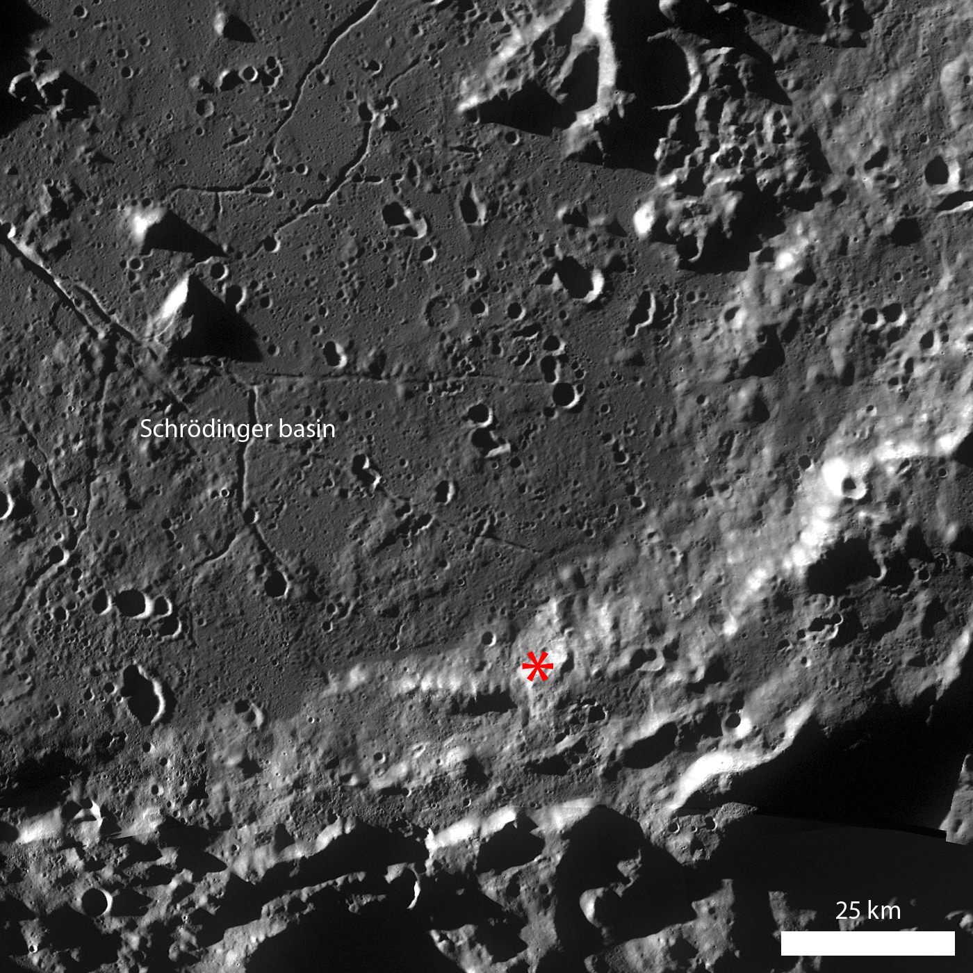
LROC Wide Angle Camera (WAC) monochrome mosaic of the south/southeastern rim of Schrödinger basin. Schrödinger basin is ~316 km in diameter and is geologically complex. Asterisk notes location of the LROC Featured Image released August 17, 2011. View the full-size LROC WAC context image HERE [NASA/GSFC/Arizona State University].

Schrödinger basin (79.13°S, 140.60°E; ~316 km diameter) is a complex geological field site. Schrödinger is located on the rim of the huge South-Pole Aitken basin and, because it impacted into South-Pole Aitken rim material, may have sampled some of the deep lunar crust excavated by the ancient South-Pole Aitken impact. Additionally, the smooth deposits on the basin floor may be a combination of both impact melt and volcanic material. There are also several pyroclastic vents located within the basin, suggesting that at least some episodes of volcanic activity in the basin had high volatile contents.


Context from the South Pole LROC WAC South Polar Mosaic, shows Schrödinger basin in relation to the lunar South Pole. View the larger image HERE [NASA/GSFC/Arizona State University].

Today's Featured Image highlights a portion of eroding basin wall terrace material. Several boulders around 30 m in diameter - roughly the distance between bases in a baseball field or about two semi-trailer trucks - rolled downhill from a boulder cluster. Their original locations may be derived using the prominent boulder trails left behind during their downhill descent. Sampling these boulders would be particularly useful during a future mission because they represent material from the basin rim and do not require an astronaut or rover to traverse to the higher elevations. In fact, the Apollo 17 mission to Taurus-Littrow sampled a boulder similar to the ones in the opening image, and scientists were later able to analyze the Station 6 Boulder and formulate hypotheses about local and regional geology surrounding the landing site.

How far did the boulders from this wall terrace bounce? Take a look in the full LROC NAC image!

Related Posts:
Bouncing, Bounding Boulders!
Bright Boulder Trail
Boulder trails in Menelaus crater


White arrow designates the location of the area within the LROC Featured Image released August 17, 2011 within the southern rim of geologically complex 316 km-wide Schrödinger basin, on the Moon's far side south polar hemisphere. HDTV still from Japan's Kaguya lunar orbiter in 2008 [JAXA/NHK/SELENE].

Saturday, August 13, 2011

LOLA: refining impact basin dimensions


Laser altimetry by LOLA, now having traveled nearly 10,000 orbits of the Moon on-board the Lunar Reconnaissance Orbiter, has confirmed the existence of impact basins once believed "questionable" [NASA/GSFC].

GSFC - This image reveals the power LOLA data have in helping scientists refine sizes of impact basins on the Moon. By studying lunar impact basins, scientists refine their understanding of what happened in the earliest stages of the formation of our Solar System, including the size distribution of early impactors.

The Sikorsky-Rittenhouse impact basin, which is estimated to be between 3.9 and 3.5 billion years old, was originally estimated to be 310 km in diameter, and its existence was considered "questionable" in Wilhelms' lunar atlas.


The ghostly Sikorsky-Rittenhouse impact basin, northwest its more-recent doppelganger, the slightly larger and still well-defined Schrodinger basin, is also visible in this LROC Wide-Angle Camera (LROC WAC WMS) global mosaic [NASA/GSFC/Arizona State University].

This initial definition was based on low-resolution images from Lunar Orbiter missions. Later Earth-based radar estimates confirmed Sikorsky-Rittenhouse's status as a basin and placed the basin diameter at 319 km. However, the use of LOLA data have helped scientists to further define the diameter size to 275 km, which represents an 11% decrease in the original diameter estimate. LOLA's high density of measurements across the Moon allows its data to create the most accurate definition of lunar craters ever.

References:
1. Jones, N. and B. Steigerwald, (2010) "NASA's LRO Exposes Moon's Complex, Turbulent Youth," 03 June 2011.
2. Wilhelms, D.E, (1987) The Geologic History of the Moon, USGS Professional Paper 1348
3. Frey, H.V. (2010) Chapter 2, GSA Special Publication Recent Advances and Current Research Issues in Lunar Stratigraphy (in press).
4. Romine, G.C., and H.V. Frey, (2011) "Using LOLA Data to Test the Reality of Candidate Lunar Basins Derived from Older Data," 41st Lunar and Planetary Science Conference, Abstract 1188, March 1-5, The Woodlands, TX.

small | large | high-res [PDF]


Late in its mission, Japan's Kaguya captured this relatively low altitude HDTV view across 98 km-wide Sikorsky (66.1°S, 103.2°E), bisected by 310 km-long Vallis Schrodinger. The northern rim, where the horns of the Valley cross through, is also the broader and essentially invisible rim of the Sikorsky-Rittenhouse impact basin. View the full-sized Kaguya HDTV image HERE [JAXA/NHK/SELENE].

Tuesday, August 31, 2010

A review of all things Schrödinger

We end August with a long-running mystery: Why has the LRO LOLA "Image of the Week" not been updated since the middle of July? One answer may be that the LOLA topography of Schrödinger basin flagged on NASA center websites served as a reminder to complete the exacting new synergistic geological map of the far south, far side basin, released Monday, August 30:


Geologic map of Schrödinger basin, which formed when a huge object struck the moon, reveals a patchwork of lunar material, including the peak ring (inner brown ring), recent volcanic activity (red), cratering (yellow) and plains material (dark green and kelly green) [NASA/Scott Mest]." >Massive Image > Sensible Image

Elizabeth Zubritsky
NASA GSFC

Schrödinger is located near the moon's south pole, a region where pockets of permanent ice are thought to exist. The map will help researchers understand lunar geologic history and identify suitable landing sites for future exploration. Scott Mest, a research scientist with the Planetary Science Institute working at NASA's Goddard Space Flight Center in Greenbelt, Md., and his colleagues created this geologic map -- the most detailed one to date -- by combining topographic data from the Lunar Orbiter Laser Altimeter, a Goddard instrument aboard the 2009 Lunar Reconnaissance Orbiter, with images and spectral data from the earlier Clementine and Lunar Prospector missions.

From August 31, 2010 -
Detail from the Schrödinger basin geologic map released by NASA GSFC, August 31, 2010 highlighting the roughly 10 x 20 kilometer area of the eastern interior occupied by the intriguing pyroclastic formation. [NASA/GSFC/Scott Mest].

Schrödinger is an example of an intriguing type of basin called a peak-ring. Like the basin rim (brown outer ring), the smaller and more fragmented peak ring (brown inner ring) is a mountainous region of crust that rose up after a huge object, probably measuring 35-40 kilometers, or about 21-25 miles, smacked into the moon here. These areas of raised crust are the oldest rocks in the basin and just about the only material that wasn't melted by the heat from the object's impact. The melted material was spewed in all directions and formed the plains. Patches of plains material can have slightly different textures and albedo (indicated by dark green and kelly green), probably because they cooled at different times. Fractures (black lines) formed in the basin floor as the material cooled.


The Clementine image of the Schrödinger basin with geological map (2010). The three landing sites and corresponding 10 km EVA radius (20 km return trip) are outlined in white. The yellow numbers correspond to following scientific points of interest: 1 – Schrödinger’s melt sheet, 2 – Schrödinger’s inner ring, 3 – basaltic units, 4 – explosive volcanic unit, 5 – deep crustal fractures, 6 – ghost craters, 7 – secondary craters, 8 – ridged terrain. - From Kohout, O’Sullivan & Kring, et.al., Scientific Opportunities for Human Exploration of the Moon’s Schrödinger Basin [LPSC 2009 #1572] The Schrödinger Basin provides a diverse suite of scientific opportunities because of the superposition of several geologic processes and because of its relatively young age. Three possible landing sites were evaluated for human exploration.

Schrödinger Basin is one of the few areas near the moon's south pole with evidence of recent volcanic activity. This includes lava flows from volcanic activity on the surface (beige areas) as well as explosive eruptions from a vent inside the red area; this vent has brought up dark material that mantles the plains (red area, which is newer than the beige regions). Older volcanic material is spread over a wider range (gray and lime green). More recent cratering by smaller objects has scattered material (yellow areas) near the top of the basin. Next to that (very light green beside yellow) is a region with a knobby texture that suggests loose material that could have come from cratering outside the basin or from a landslide on the basin's rim.

From July 16, 2010 -
LOLA Image of the Week (since July 16, 2010) Schrödinger (centered -75.0˚, 132.4˚ E), "located on the lunar far side and within South Pole-Aitken Basin, is not visible from the Earth. Crater counts suggest that the basin is less than one billion years old, making it the second youngest impact basin on the Moon (the youngest being Orientale)."

From April 23, 2010 -
Mosaic of Clementine UVVIS images (750-nm band) of the Schrödinger Basin (312 km diameter). In addition to the prominent, dark, cone-shaped feature (white arrow), Schrödinger has an inner ring of mountains partially encircling the basin floor (a ‘peak ring complex’) and a network of radial and concentric fractures. The cone is a likely volcanic vent situated on a north- east trending floor fracture, and it has a 4.5 km x 8.6 km vent surrounded by dark, explosively emplaced or pyroclastic material and a low rim. The Schrödinger volcanic vent is one of the most distinctive single-vent cones observed on the Moon and resembles ‘dark halo craters’ like those on the floor of Alphonsus. (Projection is polar stereographic, centered on the basin at -75.0°S, 132.0°E) [NASA/DOD/USGS/ASU].

From April 23, 2010 -
LROC Narrow-Angle Camera (NAC) closeup of clustered craters on the lip of the Schrödinger pyroclastic cone, a Constellation Region of Interest (ROI). Although believed to be relatively young, these craters have a subdued appearance, a texture smoothed by micrometeor 'gardening' typical of older lunar surfaces) because they formed in loose pyroclastic material. LROC NAC Frame M108313384R, this view is 785 meters across [NASA/GSFC/Arizona State University].
"A particularly interesting and unusual feature was imaged by Mini-SAR almost by accident. Because of a timing error, we started a few mapping passes of the south pole early, before the scheduled start at 80° south latitude. Good thing we did! We covered the fresh, spectacular Schrödinger impact basin, on the lunar far side. Schrödinger shows an unusual, keyhole-shaped crater along a long fissure on the basin floor. This crater is surrounded by optically dark material, which has been interpreted as volcanic ash deposits. The new Mini-SAR image shows that this material is also dark in radar reflectivity, exactly what would be expected from a fine-grained, block-free deposit. Thus, our radar images confirm the geological interpretation first derived in 1994 from Clementine images."

- Paul Spudis
Smithsonian Air & Space
March 29, 2009
From February 21, 2008 -
Kaguya (SELENE-1) multi-band imager (MI) compositional and morphological study of the Schrödinger pyroclastic formation (75.3°S, 139.1°E) [JAXA/SELENE].


Clementine (1994) and Kaguya (2008-2009). Ultra-Violet & Visible light (750-nm) UVVIS image of Schrödinger basin. b) Schrödinger DMD image taken by SELENE MI 750 nm band. c) MI 1000 nm/1050 nm absorption depth ratio from 0.8 to 1.2. From Kobayashi & Ohtake, et.al., Estimating Composition of Dark Mantle Deposit in Schrödinger Basin Using SELENE Spectral Data [LPSC 2009 #1636] Dark Mantle Deposit (DMD) regions are considered to contain glassy or crystallized pyroclastic beads. We used the spectrum data acquired by SELENE Multi-band Imager to analyze a DMD in Schrödinger basin, and estimated the composition of the DMD.

From April 23, 2010 -
Moving north (top) in a polar orbit, Japan's Kaguya took extensive HDTV of the lunar far side, including this still showing the Schrödinger Basin interior. The low and relatively darker profile of the pyroclastic dome encircling the vent is right (east) of the image center [JAXA/SELENE].

From August 31, 2010 -
Earlier Kaguya (SELENE-1) image of the eastern interior of 312 km-wide Schrödinger. The subtle differences in geologic compositions are visible, in this very-close to true-color view from 2008, though in late morning illumination the darker Schrödinger pyroclastic formation (upper center right) is an unmistakable contrast with its surroundings, in color and cratering. [JAXA/NHK/SELENE].

Finally, with sincere appreciation for all the tireless efforts underway keeping the LRO mission working and healthy, in the words of the LROC team, we urge you not to hesitate to "explore the Schrödinger Constellation region of interest for yourself!"