Showing posts with label boulders. Show all posts

Tuesday, August 5, 2014

Fractures and boulders on the floor of De Forest

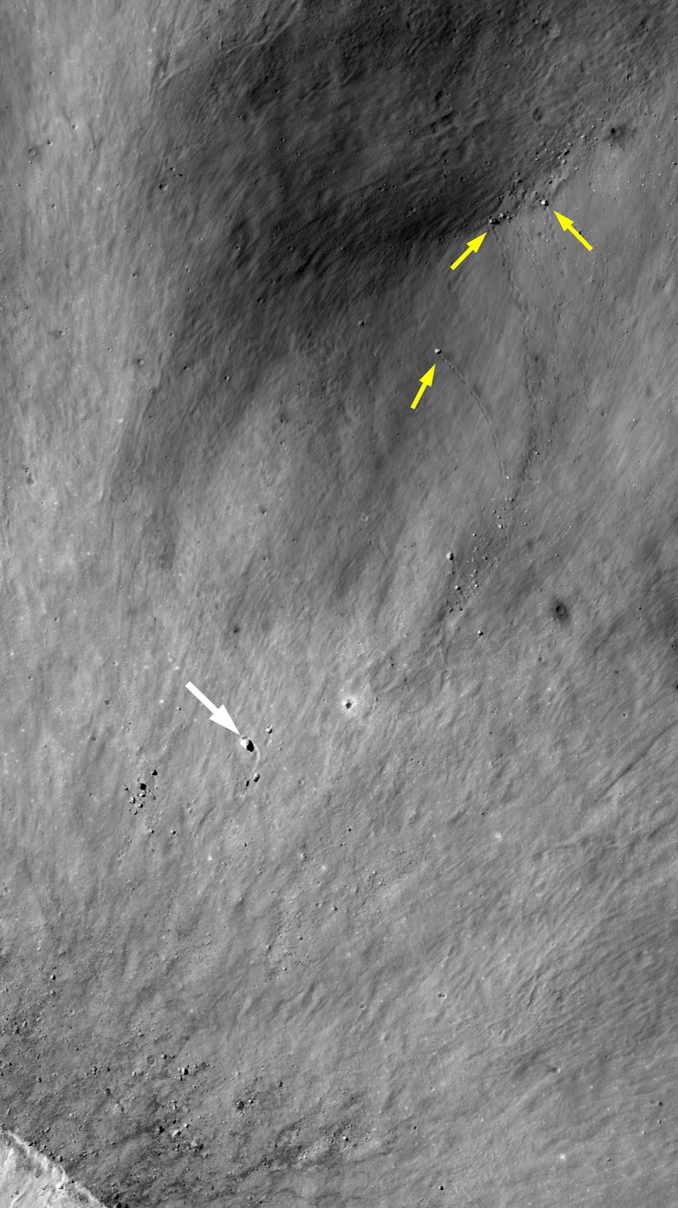
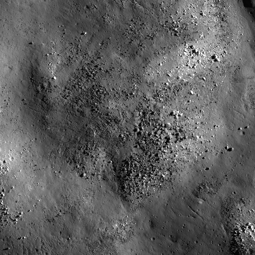
Fractured impact melt left the interior of De Forest crater (56.25 km; 76.94°S, 196.67°E) lined with boulders. 665 meter-wide field of view from LROC NAC observation M125650563L, 665 meter-wide field of view from LRO orbit 3650, April 11, 2010; 78.87° incidence angle, resolution 57 cm from 55.16 km over 77.1°S, 197.94°E [NASA/GSFC/Arizona State University].
Hiroyuki Sato
LROC News System

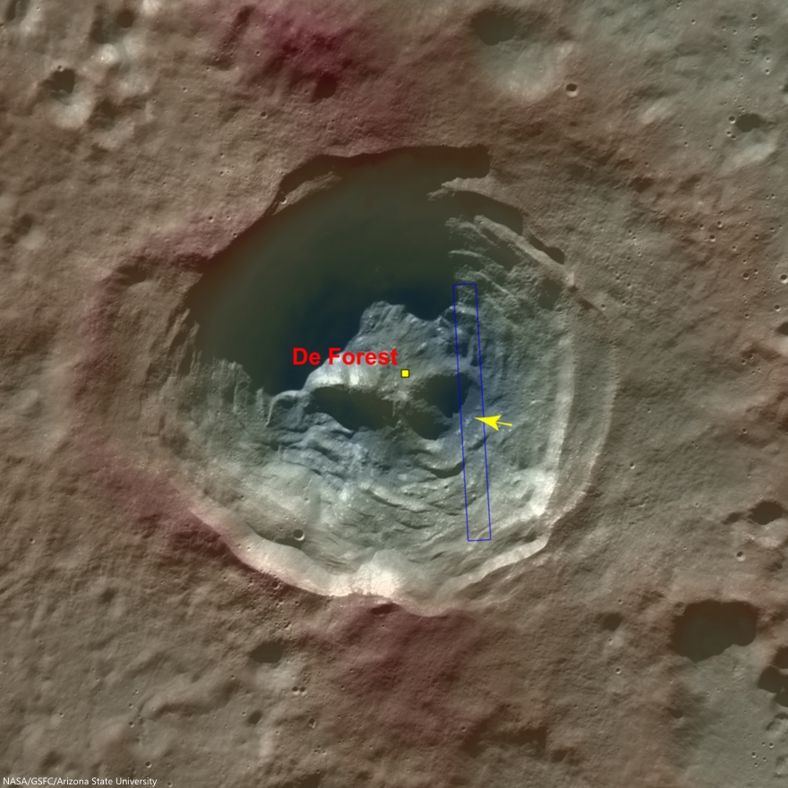
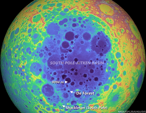
Today's Featured Image highlights a portion of the interior of De Forest crater (56.25 km; 76.94°S, 196.67°E), which is located inside the South Pole–Aitken basin.

The cavity of De Forest crater exhibits prominent terraces of collapsed materials surrounding the central peak (see context imagery following).

The topographic low, east of the central peak, was largely coated with hot impact melt which formed a hard crust as it cooled; a portion of this melt is seen in the opening image. 

Context view of De Forest crater (56.25 km; 76.94°S, 196.67°E) consisting of LROC WAC monochrome mosaic (100 m/pix) overlain with colorized WAC stereo DTM (GLD100, Scholten et al., 2012). View centered on 76.92°S, 197.51°E. Footprint of LROC NAC observation M125650563L, April 11, 2010, outlined in blue, source of high-resolution view of the area designated with a yellow arrow (LROC Featured Image released August 5, 2014) [NASA/GSFC/Arizona State University]. 
Much of the area of the opening image is covered by numerous boulders, some of which are up to approximately 15 meters across.

The smooth surface extending in lower-left to upper-right is impact melt that cooled to form solid rock, and is now fractured in regular patterns along the edge. Impact melt that was splashed on the crater's walls and its central peak formed a coating that quickly cooled to solid rock.

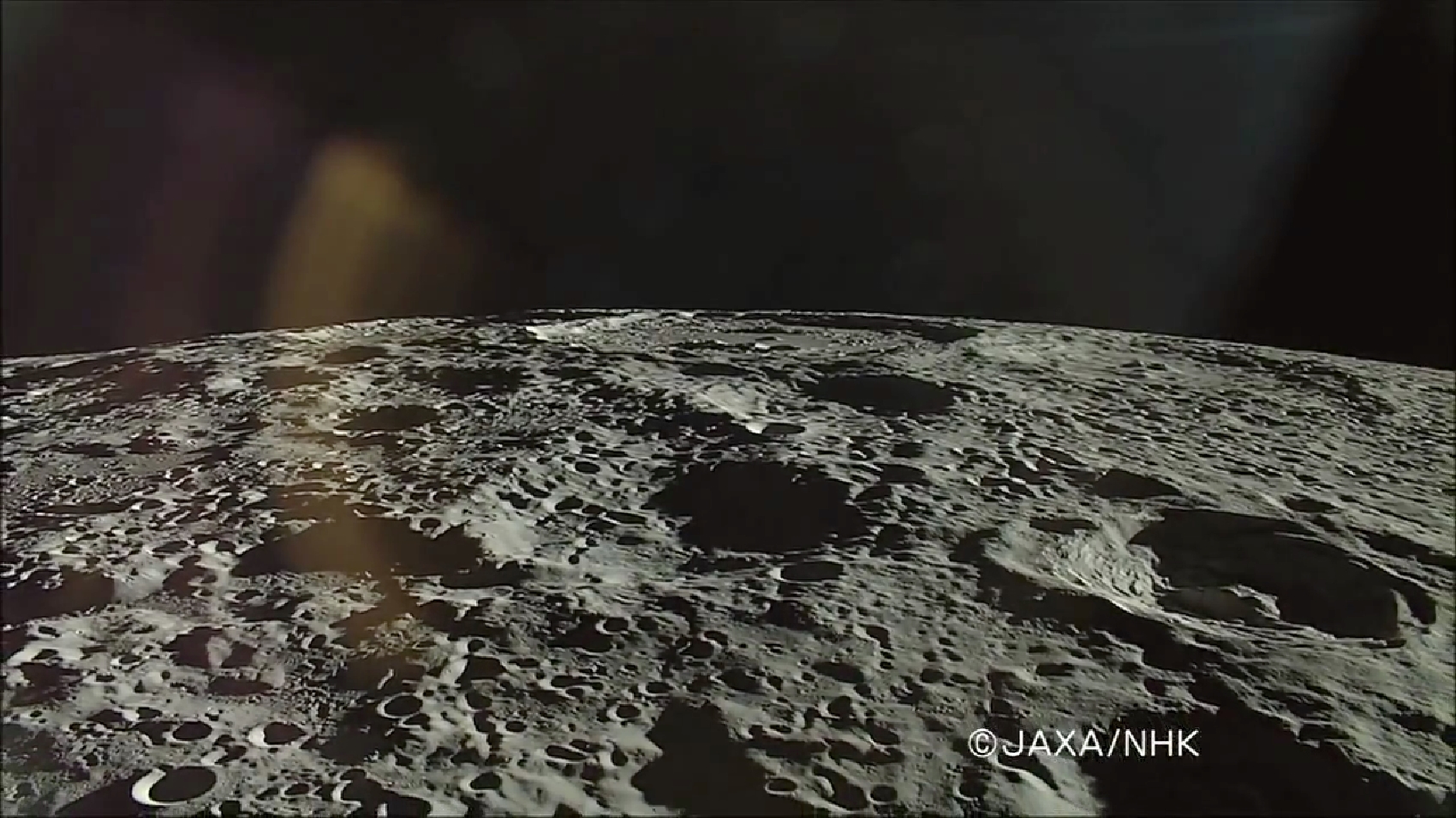
On the true "backside" of the Moon, De Forest (right) is situated well inside South Pole-Aitken impact basin, between Antoniadi (upper left, near horizon), host of the Moon's lowest elevation (-9094 meters) and Shackleton (not pictured), host of the Moon's south pole. HDTV still from Japan's lunar orbiter Kaguya (SELENE-1) in 2008 [JAXA/NHK/SELENE].
Later, it is likely that nearby moonquakes caused these brittle rock coatings to fracture, providing the source of boulders we now see on the lower reaches of the crater floor.

De Forest's position in the far south Farside is an area hosting Permanently Shadowed Regions (PSR's). The neutron detection experiment on-board LRO (LEND) has built up signatures consistent with cold-trapped volatiles, like water ice, in the vicinity. Image from Science Visualization Studio tour of SPA, larger image HERE [NASA/GSFC/Arizona State University/DLR/SVS]. 
As you can see in the following full NAC frame, an enormous number of similar boulders are found along the smooth melt deposits on the floor of De Forest crater. 

Explore this boulder-rich crater in the full NAC frame, HERE.

Related Posts:

Monday, July 21, 2014

Ballistic boulder at Hecataeus N

A house-sized boulder left a clear impression, immediately beyond the east rim of a young 1.6-km crater (rim crest to the left), all in a full-sized reproduction, 988 meter-wide field of view from LROC NAC observation M182995612R, LRO orbit 12068, February 4, 2012; 48.59° incidence, resolution 85 cm from 83.56 km over 20.98°S, 80.74°E [NASA/GSFC/Arizona State University].
J. Stopar
LROC News System

The boulder above (21.085°S, 80.777°E) in the opening image is likely debris ejected during the violent excavation of the 1.6-km diameter crater immediately to the west (left).

The boulder was deposited ballistically; the distance it travelled and its time of flight are related to its ejection angle and velocity.

For the boulder, was this flight a "small step" or a "giant leap?"

Looking at the image above, we can deduce that the boulder was deposited with enough force to make a noticeable impression in the ground. However, a more forceful landing would have highly fragmented the boulder.

More examples of surface impressions formed by ballistic boulders from the fresh impact near Hecataeus N. Spotty trails mark where boulders rolled into a pre-existing crater (small yellow arrows). Another larger, boulder (25 meters in diameter, large white arrow) was thrown out of the crater to the southwest and carved a furrow in the ejecta blanket, coming to rest when it intersected a pre-existing crater rim (topographic high) [NASA/GSFC/Arizona State University].
The boulder is located about 500 meters east of the crater rim crest, which is only about a third of the crater diameter. Thus, this boulder did not travel very far or very fast.

Explore the entire crater and its ejecta below:

Fresh impact on the west flank of Hecataeus N 4.3 km field of view from LROC NAC mosaic M182995612LR, LRO orbit 12068, February 4, 2012; 48.59° incidence, resolution 85 cm from 83.56 km over 20.98°S, 80.74°E [NASA/GSFC/Arizona State University].
View full-window HERE.

The house-sized boulder (yellow arrow), which left its impression just beyond the east rim of the unnamed young 1.6-km crater that, in turn, sits on the west flank of Hecataeus N, shown in the context of a 7.86 km-wide field of view from LROC NAC mosaic M182995612LR, LRO orbit 12068, February 4, 2012; 48.59° incidence, resolution 85 cm from 83.56 km over 20.98°S, 80.74°E [NASA/GSFC/Arizona State University].
The fresh crater (center) on the southwest slope of Hecataeus N (10.82 km; 20.91°S, 80.944°E) excavates the deepest material originally turned up by "N" while both, in turn, sampled the very ancient Hecataeus interior (southwestern half of this 40-km wide field of view) and, even further, material turned out by Humboldt, to the south (see below), a powerful impact that significantly filled in and covered over the floor of Hecataeus. This is an example of something planners look when making good landing site choices, ones likely to efficiently utilize precious resources. LROC WAC observation M177109146C (604 nm), LRO orbit 11236, November 28, 2011; 68.1° incidence, resolution 58.91 meters from 43.76 km [NASA/GSFC/Arizona State University].
A general schematic map of geological types, representing the relative stratigraphy of the lunar surface affected by Hecataeus and Humboldt, in the south equatorial latitudes of the far eastern hemisphere, where the farside highlands begin, The fresh crater on the west flank of Hecataeus N is marked by an arrow.
The grooves carved by boulders ejected at relatively low velocities are in many ways similar to the spotty tracks etched by boulders sliding, rolling, and bouncing down steep slopes. Also, boulder tracks (like these) often resemble the astronauts' footprints on the lunar surface, since both have relatively recently disturbed the soil in narrow paths. 

In honor of the 45th anniversary of the Apollo 11 lunar landing (July 20, 1969), revisit some of our previous posts about large boulders visited by astronauts:


Finally, revisit some of the best LROC images of the Apollo 11 landing site and see if you can find any large boulders. You should find very few large boulders, as the mission planners sought a low-risk site for the first Moon landing:

Friday, February 7, 2014

Layering Waves at Darwin C

Fresh Impact at Darwin C (LROC NAC)
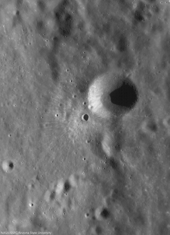
A fresh impact crater that poured ejecta down the wall of Darwin C in a 7 km field of view from LROC NAC mosaic M1145254989RL,  spacecraft orbit 20807, January 25, 2014, resolution 0.8 meters, north toward left [NASA/GSFC/Arizona State University].
Raquel Nuno
LROC Featured Image

We previously published a portion of the spectacular ejecta pattern of an unnamed fresh impact crater: "Impact Art," November 21, 2013.

 Today's Featured Image is a broader LROC NAC mosaic of the source where that ejecta originated. This unnamed crater does not have a circular shape, because it formed on the sloped wall of Darwin C crater (15.3 km, 20.51°S, 71.12°W).

Soon after impact, gravity took over, pulling large boulders and fine debris down the crater wall. Zooming in on the ejecta, you can see roughly boulders roughly 6 meters in size that "etched" their way down the crater wall, leaving trails in the granular ejecta as they tumbled downhill.

M1145254989RL_context
Boulders rolled down slope leaving evidence of their trek in their wake. They ended their journey after the impact that formed the fresh crater on the wall of crater Darwin C, as can be seen by the overprinting of their trails on the ejecta. The boulders are roughly 6 meters in diameter [NASA/GSFC/Arizona State University].
Since we don't have samples from this crater, we don't know exactly when this fresh impact crater occurred.  But, we can assume that it must be relatively young.

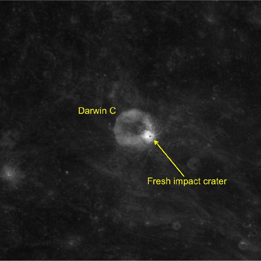
The reason why we know it must be young is that exposure to the space environment (usually referred to as space weathering) reduces the albedo of surface materials.  This means that scientists can use LROC images to get a relative sense for how long a surface has been exposed to the space environment. Getting some perspective with the wider view, combined with examination of the 643 nm normalized WAC reflectance map which enhances relative reflectance (see image below), you can see the relative brightness difference between the high-reflectance ejecta from our fresh crater compared to crater Darwin C and the rest of the surrounding terrain - this crater is not only superposes Darwin C, but its ejecta is significantly higher reflectance than anything else in the scene.

Albedo Optical Maturity of a fresh impact on the wall of Darwin C
LROC Wide Angle Camera (WAC) 643 nm normalized reflectance map of Darwin C crater. The bright area is ejecta from the fresh impact crater on the east wall of Darwin C [NASA/GSFC/Arizona State University].
Taken together with the sharp, well-defined rims and lack of other superposed impacts, we can infer that this crater is a relatively recent addition to the lunar surface.  The impact event that formed this crater almost certainly occurred within the last several hundred million years, which is practically yesterday over the billions of years of geologic time!

Follow the boulders' trails with the full resolution NAC mosaic, HERE.

Related Posts:
Impact Art
A Tangle of Talus
Bouncing, Bounding Boulders!
It's All Downhill From Here

Tuesday, January 28, 2014

Boulders on a hill on the floor of Rutherfurd crater

Boulders on the floor of Rutherford (LROC NAC)
Knobby surface of Rutherfurd crater floor, 1050 meter-wide LROC NAC field of view centered on 61.340°S, 348.085°ENAC M1123653329R, spacecraft orbit 17669, May 20, 2013; incidence angle 81° from 50.83 km  [NASA/GSFC/Arizona State University].
Hiroyuki Sato
LROC News System

Today's Featured Image highlights a bumpy hill adjacent to a large melt pool (now frozen to solid rock) inside Rutherfurd crater (48 km in diameter). As seen in the WAC context image below, the floor is mostly littered with materials that collapsed and slumped from the crater wall, and with impact melts filling the topographic lows.

Uphill is to the left of the image, here you can see a wrinkled/fractured surface, likely formed as a thin rigid sheet of frozen melt. Over time this melt rock slowly broke apart -- the source of other boulders. The boulders slowly migrate downhill, breaking themselves apart, a form of mass wasting similar to that seen on Earth. However there is a big difference, almost all the energy on the Moon is provided by a continual rain of small meteorites, whereas on the Earth erosion is driven by plate motion induced earthquakes, and weathering.

Rutherfurd crater (LROC WAC)
49.98 km Rutherfurd crater (61.15°S, 346.278°E), nested on the rim of more famed, much wider and older Clavius, in the nearside southern highlands. The area captured at high-resolution and released as the LROC Featured Image, January 28, 2014, is marked with an arrow. LROC WAC global mosaic [NASA/GSFC/Arizona State University].

Rutherfurd from Earth (Damian Peach)
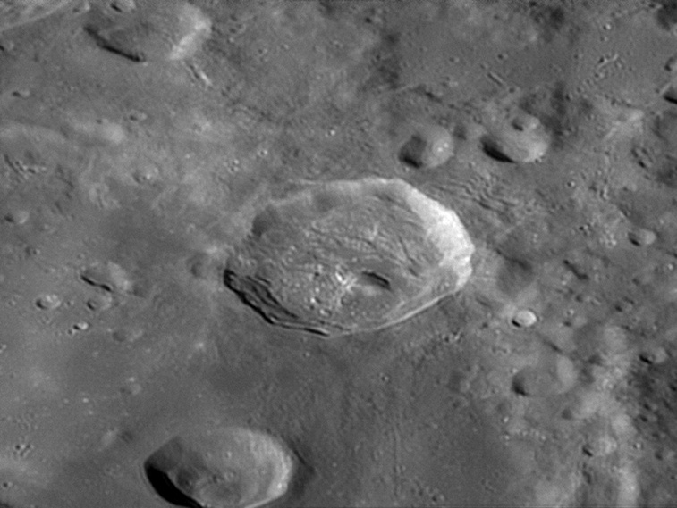
Rutherfurd as viewed from Earth by experienced astrophotographer Damian Peach, November 20, 2005. "Rutherfurd is located entirely within the southern rim of much larger Clavius," he writes. "Rutherfurd is somewhat oval in shape, with the long axis oriented approximately in a north-south direction. The rim is overlaying the inner wall of Clavius, and thus the rim of Rutherfurd is higher above the surface along the north and west sides. The floor is irregular in shape, and there is a central peak somewhat offset to the northeast. The ejecta pattern; oblong shape, and location of the central peak indicate the original impact may have been at a low angle from the southeast [Damian Peach].
Rutherfurd on the rim of Clavius (LROC WAC)
49.98 km Rutherfurd (61.15°S, 346.278°E), nested on the southeastern rim of more famed, much wider and older Clavius, in the nearside Southern Highlands. The area captured at high-resolution and released as the LROC Featured Image, January 28, 2014, is marked with an arrow. LROC WAC global mosaic [NASA/GSFC/Arizona State University].
Explore the floor of Rutherfurd crater in the full NAC frame with very low sun, HERE.

Related Posts:
Central Peak of Rutherfurd
Rough Crater Wall Surface
Sinuous Cracks
View From The Other Side
Cracked mound
A beautiful bench crater (Rutherfurd)

Sunday, December 15, 2013

Apollo 17, Station 6

Station 6, Apollo 17
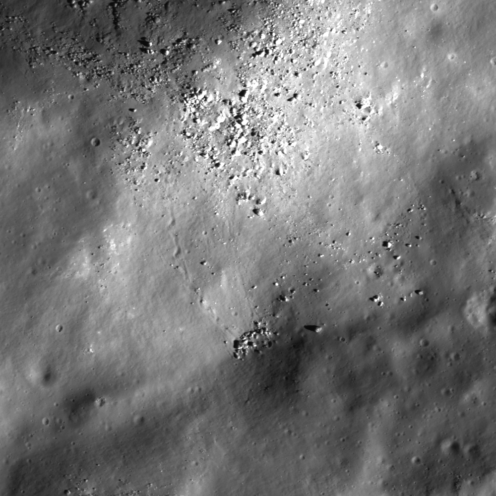
Station 6 allowed Apollo 17 astronauts Eugene Cernan and Jack Schmitt to explore a collection of boulders and regolith that represent rocks from the mighty North Massif. Five large boulder fragments lie at the base of a long boulder trail, all from a single boulder that rolled down the hill and broke apart. LROC Narrow Angle Camera (NAC) observation M134991988R, spacecraft orbit 5027, July 28, 2010; angle of incidence 64.66° at 0.5 meters resolution from 43.83 km over 19.19°N, 30.8°E [NASA/GSFC/Arizona State University].
Jeffrey Plescia
LROC News System

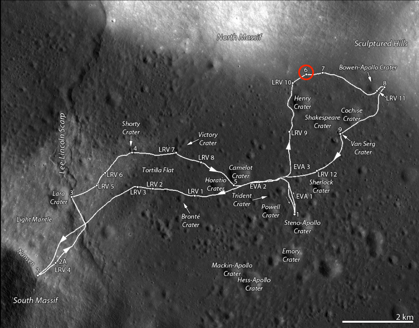
The North Massif lies along the northern side of the Taurus-Littrow Valley, the landing site of Apollo 17. Station 6 was visited during the third and final surface EVA of the expedition and of the Apollo program, December 13, 1972, and was intended as a location to collect ancient highland material from the North Massif as well as a dark mantle that locally covers the region.

The sampling station is about 100 meters above the general valley floor elevation of 2560 meters below global mean average. The North Massif rises some 1400 meters above Station 6 and likely formed in a few seconds as the result of the massive impact that created the Serenitatis Basin.

One of the key science goals at Station 6 was to collect impact melt caused by that event. When rock is melted its radiometric clock is reset to time zero, so a sample of impact melt can be age-dated to determine when the basin formed.

Station 6, Apollo 17
Traverse map of the Apollo 17 site. Station 6 is along the base of the North Massif on the north side of the valley and is circled in red [NASA/GSFC/Arizona State University].
At Station 6, five large blocks are clustered together on a surface that slopes toward the valley floor at about 16°. They lie at the end of a 980 m long boulder trail that formed as a single large boulder rolled down the hill. The trail is about 10-12 m wide with a scalloped edge and periodic small transverse ridges. This irregular pattern is the result of the irregular shape of the boulder. The original boulder was probably about 18 x 10 x 6 m. The largest fragment (Block #2) is about 10 m across.

It appears that the rolling ceased when the boulder broke apart and came to the rest in its present location. As the boulder rolled down the hill slope, it pushed up material along the edge of the track forming a berm. A small berm is also visible in front of the largest fragment. An expanded view of the boulders from an LROC image is shown below. Subtle brightness differences are apparent in the largest boulder in the center, and correspond to different rock types (the boulder is a breccia).

Station 6, Apollo 17
The five major blocks at Station 6, and an additional one farther down slope, are clearly visible in LROC NAC M134991788RE, as is the boulder trail above the blocks. Afternoon illumination, sun from the west [NASA/GSFC/Arizona State University].
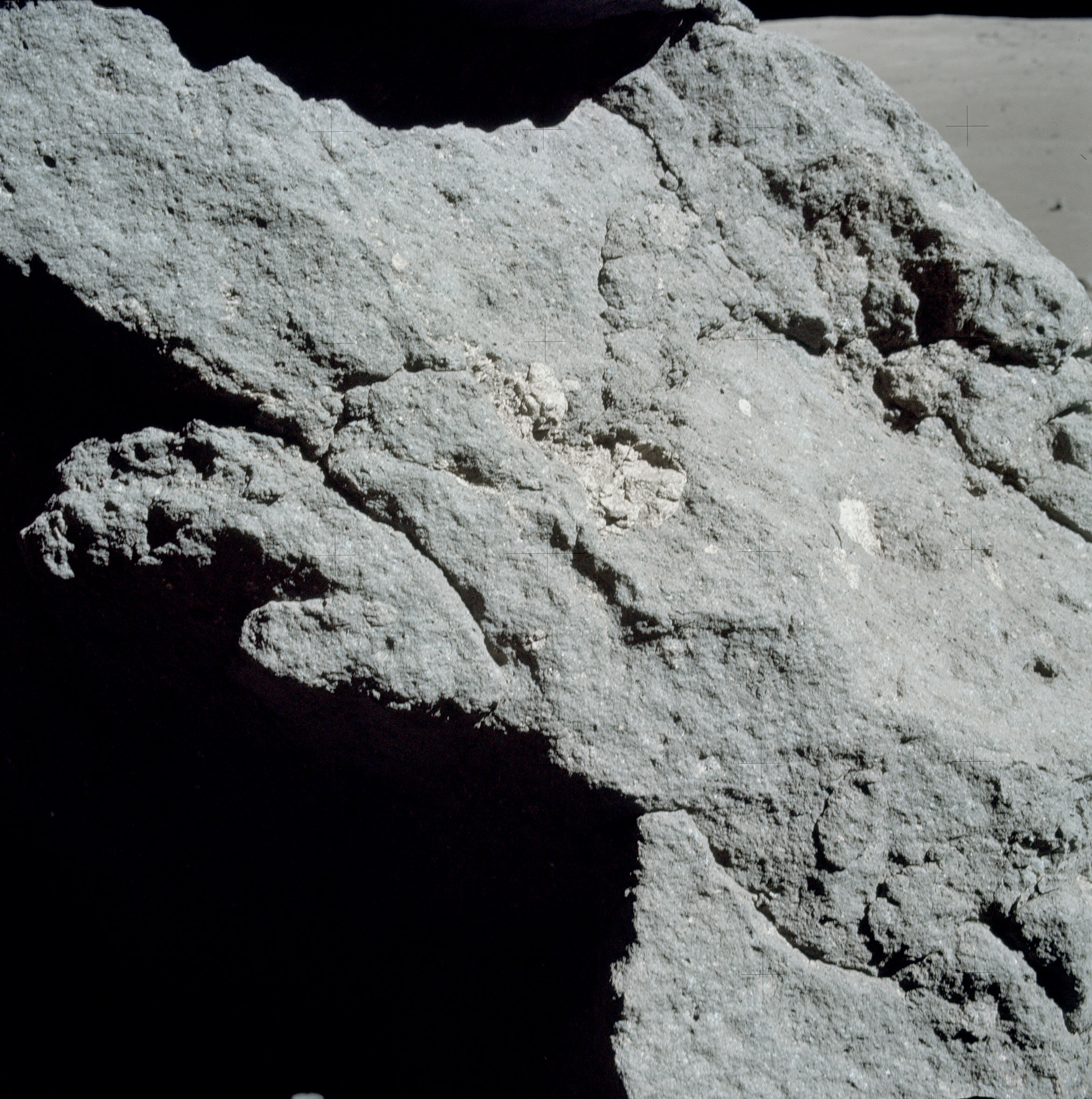
Pictures taken during the Apollo 17 EVA at Station 6 illustrate the relative size of the boulders; below Jack Schmitt is seen after after sampling the boulders.

Station 6, Apollo 17
Jack Schmitt picking up the gnomon after collecting samples. This view is to the southwest, and the Apollo 17 lunar module stands sentinel in the upper right deep background (AS17-140-21496) [Eugene Cernan/NASA/JSC].
Jack Schmitt put the Apollo 17 lunar module "Challenger" in some perspective, capturing this monochrome shot, through a 500 mm lens, and from over 3 km) from Station 6. From another panorama of EVA images, AS17-139-21203-5 [Harrison Schmitt/NASA/JSC].
A number of samples were collected at Station 6. The illustration below shows the boulder group and a map made during the mission. The map indicates the location of the rock and soil samples as well as the location of the panoramic images.

Station 6, Apollo 17
LROC image of the boulder complex (top); map of the boulder segments and the sample locations (below). North and South Panoramas designate locations where the hand-held panoramic image sequences were captured. The numbers refer to specific Apollo samples [NASA/GSFC/Arizona State University].
Samples from the station include a single drive tube, ten rock samples (3 from the surface, four from block 1, one each from blocks 2, 4, and 5), several sediment samples (3 from between major blocks, one down slope from the blocks, one from the boulder track, and another from on top of block 1), and one rake sample from the ejecta blanket of a small crater to the northwest of the blocks.

Station 6, Apollo 17
Light-colored inclusions in the matrix of one of the boulders (Block 1) (AS17-140-21442) [NASA/JSC].
The boulders consist of clast-bearing impact melts. Despite the color differences, foliation and frequency of vesicles, the boulders consist of a chemically uniform matrix with clasts ranging in size up to about 1 meter in diameter. The clasts consists of rocks across the anorthosite-norite-troctolite suite or their impact-modified derivatives. Simonds (1975) suggested that the matrix is a clast-bearing rock formed by the mechanical mixture of cold, generally little-shocked clasts and superheated impact melt that rapidly quenched to form very-fine subophitic to ophitic crystalline groundmass. These samples have ages of around 3.98 Ga and are interpreted to represent the age of basin-forming event that produced the material, probably the Serenitatis Basin (as discussed in Ryder et al., 1997). However, more recent work suggests that the rocks collected at Station 6 may actually be ejecta from the Imbrium Basin forming event.

Explore the Taurus-Littrow Valley yourself, HERE.

Previous LROC Featured Images RE: Apollo 17:
Oblique view of Taurus Littrow, from the West (December 19, 2012)
Approach To Taurus Littrow Valley (December 11, 2012)
Taurus Littrow Oblique (September 29, 2012)
Question Answered! (July 17, 2012)
Just Another Crater? (December 13, 2011)
Skimming the Moon (September 6, 2011)
Exploring the Apollo 17 Site (October 28, 2009)

Thursday, December 12, 2013

Bowl of Boulders in Steno Q

NAC_ROI_STENO_Q_LOA_thumb-580x820
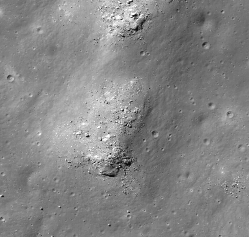
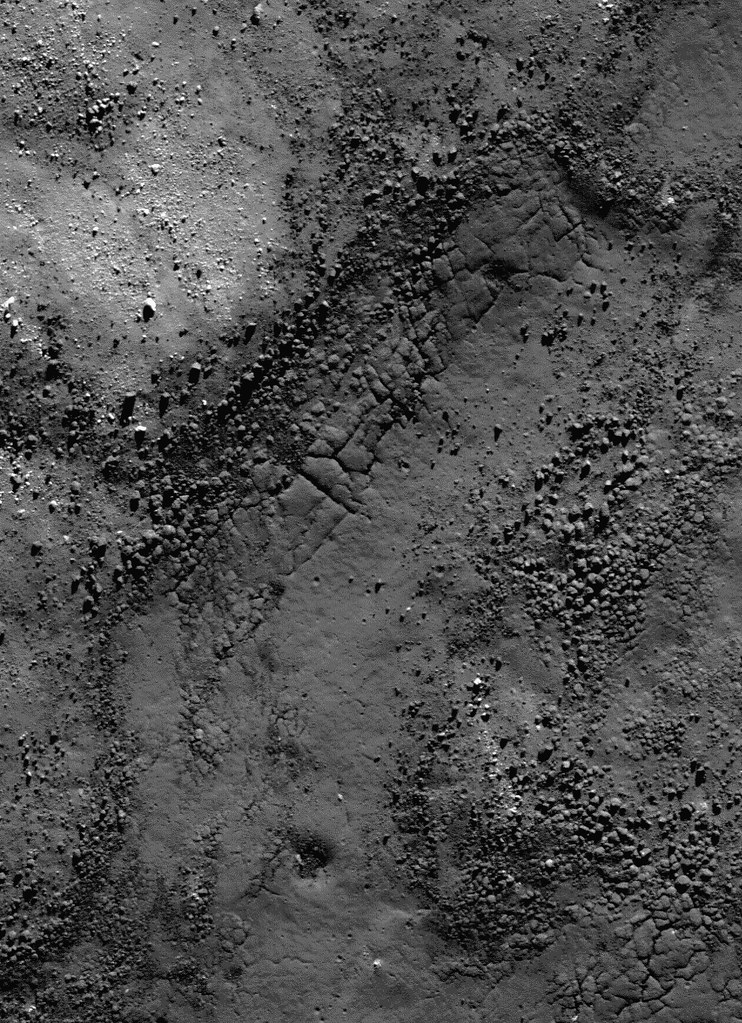
Boulders collect in a small depression right in the middle of the central peak cluster of Steno Q crater (20.063°N, 157.728°E) . Some of these boulders are as big as houses. Field of view 870 meters, portion of NAC controlled mosaic, illumination from the southeast [NASA/GSFC/Arizona State University].
J. Stopar
LROC News System

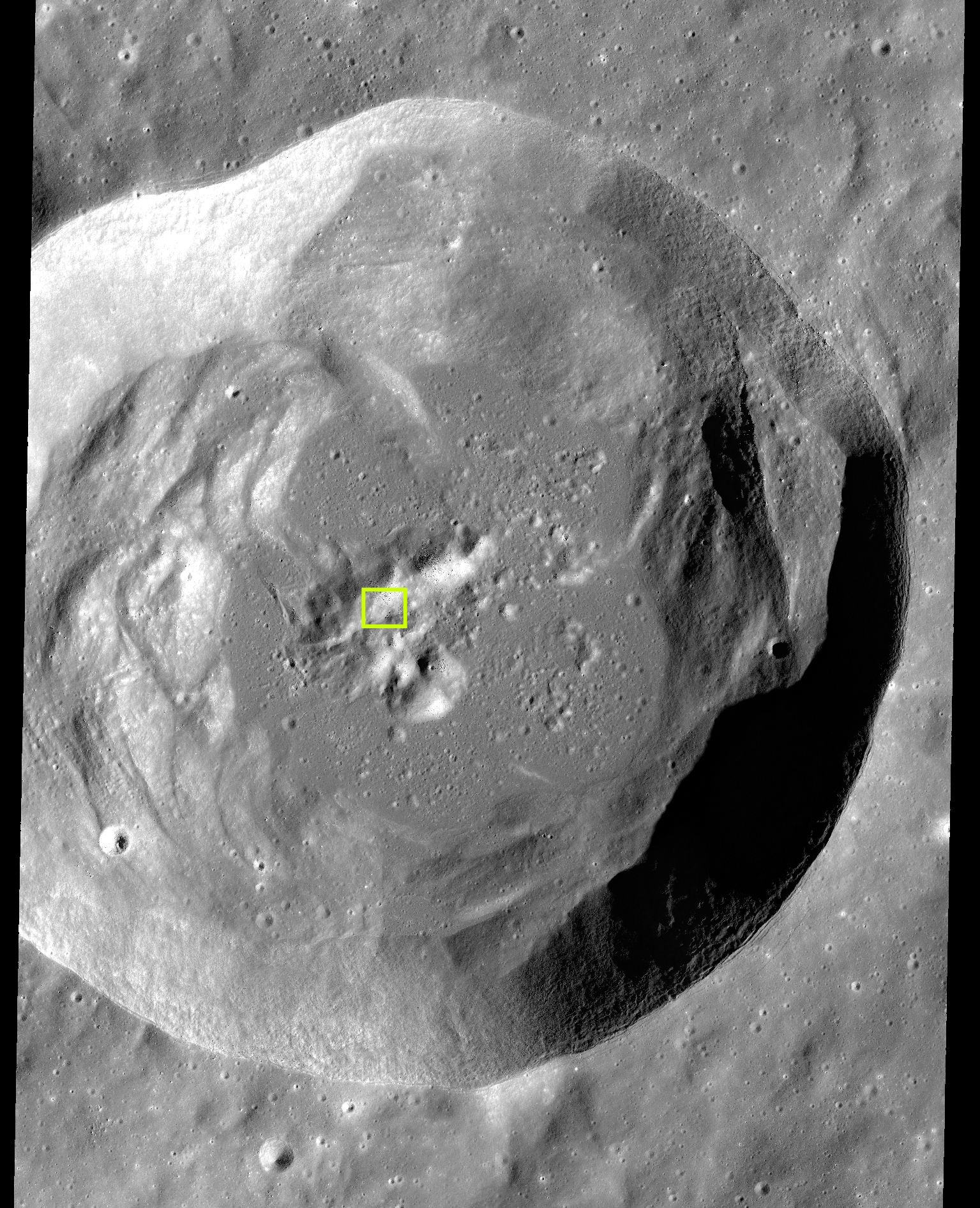
Steno Q is a 32 km diameter crater located in the highland terrain east of Mare Moscoviense. Impact craters, including Steno Q, are formed through a three-stage process consisting of: 1) contact and compression, 2) excavation, and 3) modification.

The initial crater cavity is formed during the excavation stage; during this stage, the excavated material is ejected from the crater, leaving a roughly bowl-shaped void. During modification, the last stage, the shape of the crater cavity adjusts as a function of planetary gravity and scale of impact. For larger impacts, a complex crater shape is formed as a result of a large degree of crater modification: the walls of complex craters slump through gravitational instability, a central peak forms through rebound, and impact melt and debris collect in the crater floor. Typical of other similarly sized Copernican age craters (those younger than 1 billion years), Steno Q preserves a central peak, steep walls with large slump blocks, and a sizeable pond of solidified impact melt rocks covering the lowest parts of the crater cavity.

Explore more complex craters around the Moon at the following LROC Featured Image posts: "Terraces in Eratosthenes Crater," "Not your average complex crater," "Impact melt features in Tycho craters floor," "Aitken Central Peak, Seen Obliquely," "Icarus," "Copernicus Central Peak From The West."

stenoQ_centralpeak-1086x1000
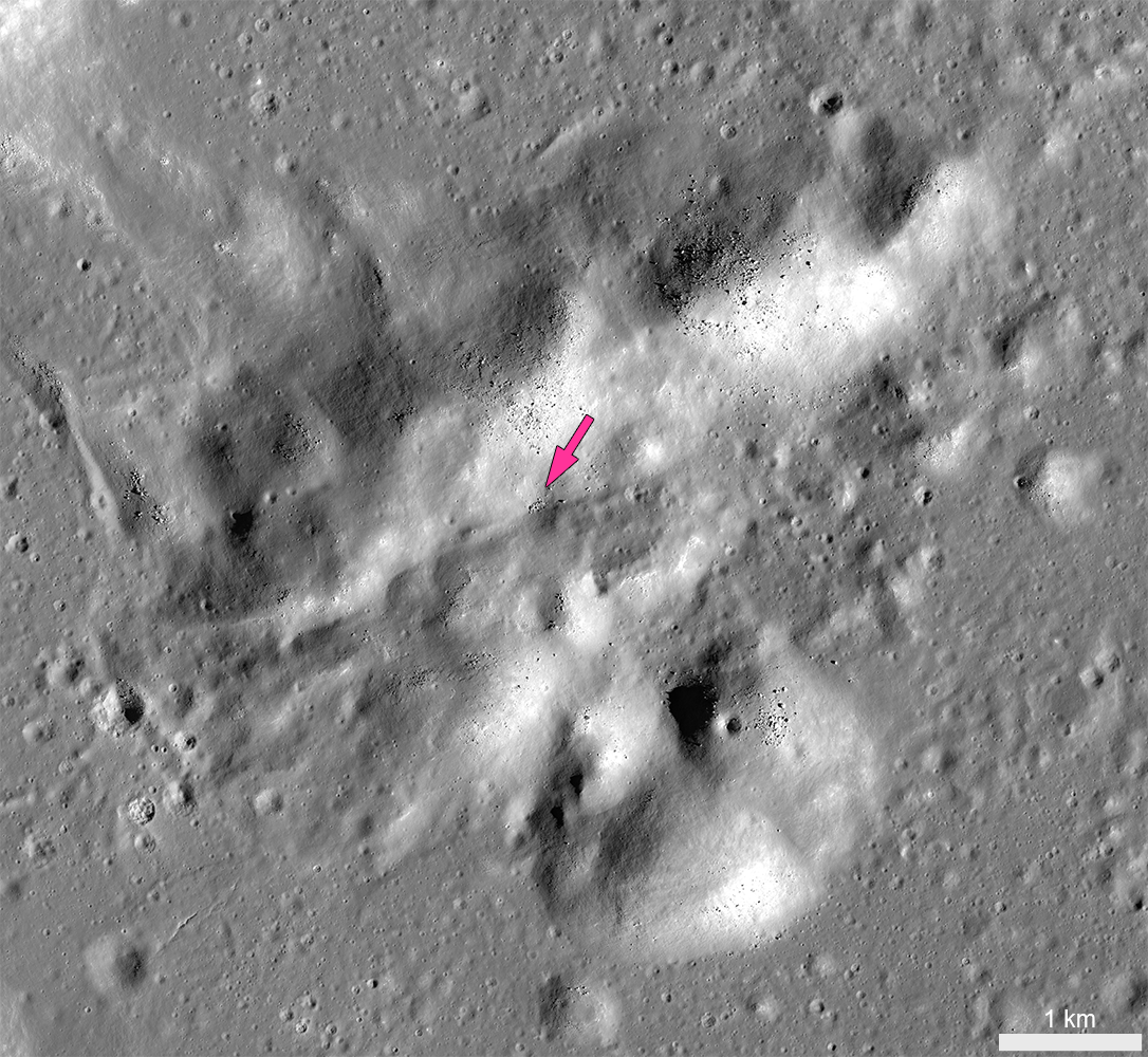
Central peak of Steno Q crater, with the location of the "Bowl of Boulders" shown at high-resolution in the LROC Featured Image indicated by the arrow [NASA/GSFC/Arizona State University].
Today's Featured Image closely examines part of the central peak of Steno Q, roughly 10 kilometers wide and consisting of mountains more than 2000 meters high.

The crests of several of these mountains are blocky and composed of highly stressed and fractured materials from the deepest part of the crater. Over time, boulders perched on these steep slopes can roll downhill as a result of seismic tremors and the shaking caused by nearby impacts. A small depression near the middle of the central peak preserves a collection of boulders accumulated from upslope.

Some of these boulders are more than 20m wide -- as big as a house. To get an idea of just how big that is, watch this video, HERE, of Apollo 16 astronauts Charles Duke and John Young approaching similarly-sized "House Rock," on the rim of North Ray crater.

Charlie Duke samples a shatter cone formation in "Outhouse Rock," a large fragment shed off the southern end of "House Rock," during the third and final EVA of Apollo 16 in 1972. Note the accumulation of lunar dust after totaling 20 hours on the lunar surface. (AS16-116-18649) [John Young/NASA/JSC/ALSJ].
At Steno Q, trails of the most recent boulder falls indicate the source of the material upslope. Boulder accumulations like this provide a unique opportunity for future explorers to collect a variety of materials derived from potentially inaccessible areas, like steep mountain peaks or the deepest components of the original surface excavated by the crater-forming impact.

stenoQ_context1-1535x1892
Complex crater Steno Q, (32 km, 29.063°N, 157.728°E). Typical of lunar craters of this size, Steno Q underwent extensive crater modification during the impact process, including wall slumping, central peak uplift and impact melt ponding. The box encompasses the field of view in the LROC Featured Image released December 12, 2013 [NASA/GSFC/Arizona State University].
The images in this post were derived from a 1.5 meter per pixel-scale LROC NAC controlled mosaic -- allowing users to explore the entire Steno Q crater, HERE.

Related LROC Posts:
Bouncing, Bounding Boulders!
Boulder trails in Menelaus crater
Rolling Rolling Rolling
Boulder Tales
Bounce, Roll, and Stop
Lazy Boulders in Scaliger Crater
A Recent Journey

Friday, October 4, 2013

Orientalis fall out at Inghirami C?

Boulders scattered across mounds on the floor of Inghirami C may be ejecta nested in melt that originated with the basin-forming-impact that created Mare Orientalis and it's extensive basin 3.1 billion years ago. LROC Narrow Angle Camera (NAC) observation M1114645692L, LRO orbit 16501, February 4, 2013, full 64 cm per pixel resolution crop centered at 44.167°S, 285.309°E. LROC Featured Image field of view roughly 500 meters across, 54.74° angle of incidence [NASA/GSFC/Arizona State University].
H. Meyer
LROC News System

The floor of Inghirami C is littered with boulders that are commonly perched atop closely spaced mounds, some of which are as large as 700 meters by 1000 meters. The presence of these mounds and boulders gives the floor of the crater a lumpy appearance. If simple craters are supposed to be bowl-shaped, where did the material come from to form the mounds? Inghirami C is located southeast of Orientale basin and is adorned with spectacular patterns of ejecta during the basin forming event. Could the lumps and boulders be material from Orientale?

Full 3.2 km-wide field of view of LROC NAC M11144569LE, with the area highlighted at high resolution above outlined in yellow. While amorphous mounds and melt mixtures are common features covering floors of larger craters, like Copernican age Tycho, these features appear more cohesive with no intermediate stages of mixture with their surroundings and mass wasting characteristic of far flung boulders [NASA/GSFC/Arizona State University].
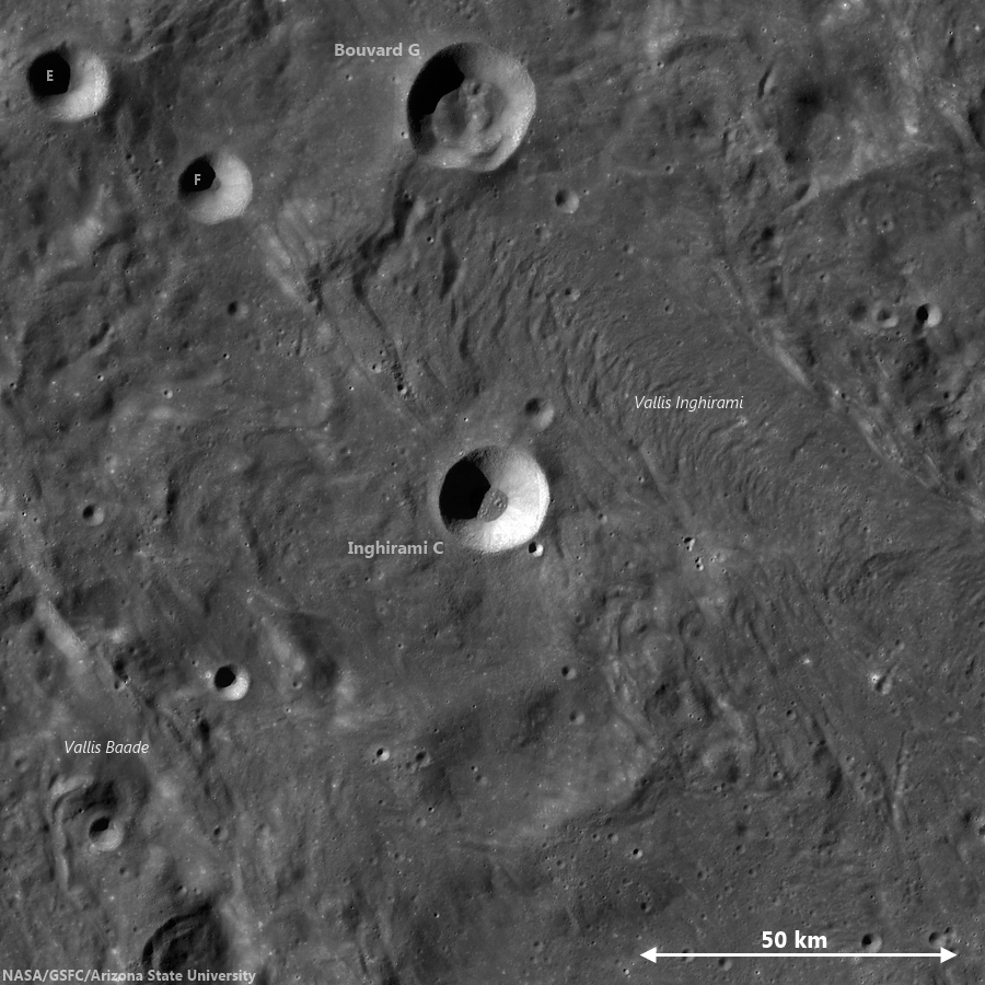
A medium resolution, low illumination angle view of Inghirami C shows the hint of an ejecta blanket from the 19 km crater and its blocky floor, in context with immediate surroundings deeply grooved by forces radiant from the Orientalis basin. Chang'e-2 global photographic [CNSA/CLEP].
In the Wide Angle Camera (WAC) context image (below), the walls of Inghirami C are intact. There are no breaches in the walls to suggest that ejecta from Orientale flowed directly into the crater. If you look closely, you can see a hint of an ejecta blanket outside the rim of Inghirami C. The presence of this ejecta blanket (from Inghirami C) and the lack of breaches suggest that Inghirami C formed on top of the Orientale ejecta.

Inghirami C
LROC GLD100 mosaic showing Inghirami C nested in the midst of a wide area of terrain grooved and infilled by eject from the Orientalis basin-forming-impact. The same influence, radiant from Orientalis, continues far to the southwest and may explain the atypical fill in and around other craters in the Schickard crater group at even greater distances, including Wargentin [NASA/GSFC/Arizona State University].
Using basic stratigraphic principles, this means Inghirami C formed after the Orientale ejecta formed the ridged terrain (seen just outside the rim of Inghirami C in the context image). If the material in the floor didn't come from Orientale or any other large crater nearby, then it must be native to Inghirami C. It turns out that not all simple craters are bowl-shaped with smooth floors -- and in fact many display textured floors covered in combinations of breccias, impact melt, and ejected blocks that can form mounds. Over time, the mounds erode, leaving the boulders seen in today's Featured Image.

Back to the question: Could the lumps and boulders be material from Orientale? Not directly as established above, but perhaps the irregular forms are due to an impact into a chaotic, unconsolidated massive ejecta flow from the Orientale event! The lunar surface is incredibly complex - everywhere you look there is something new, waiting to be explored!

Check out the rest of this exquisite terrain HERE.

Read more about impact excavation:
Excavating Deposits
Polka-dot Ejecta
Off-centered deposits
Forked Impact Melt

Tuesday, June 25, 2013

Farside Boulders, Curve Northeastward

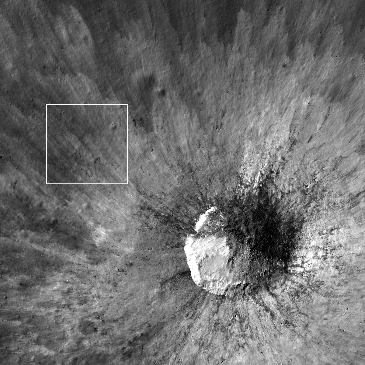
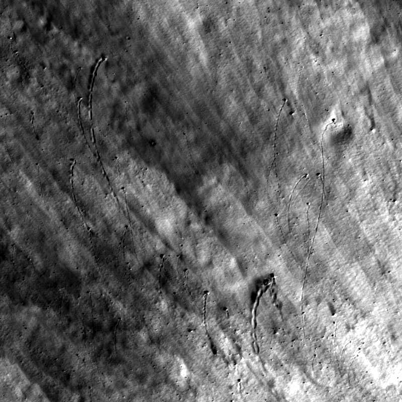
Curved boulder tracks outside the rim of a fresh crater on the farside highland terrain southeast of Mare Moscoviense. LROC Narr wo Angle Camera (NAC) observation M143594908L, spacecraft orbit 6295, November 10, 2010; field of view 320 meters across, 39.27° angle of incidence, resolution 58 cm per pixel from 55.36 km [NASA/GSFC/Arizona State University].
Sarah Braden
LROC News System

The boulders in the Featured Image all curve to the northeast, carving dark paths across the fresh rays from a small 525-meter crater on the lunar farside northeast of Van Gent U, 17.233°N, 157.367°E.

The boulders originated from the impact crater itself, being ejected during the impact event with a velocity radial to the crater rim.

As the boulders bounced and rolled along the surface they lost speed (kinetic energy) and slowed, creating gently curving paths until they came to a stop.

Wider field of view from LROC NAC M143594908L, context showing the location of the boulders with respect to their source crater in a field of view 1.9 km across [NASA/GSFC/Arizona State University].
The curved paths are likely caused by the preexisting slope of the topography, which is slightly downward sloping to the northeast (~10°). The linear striations of the fresh ejecta define the radial direction away from the crater and provide a beautiful contrast for the curved boulder paths.

Using the latest LROC QuickMap, a 2.09 by 2.09 km wedge of terrain is shown in 3D, and turned 90° counter-clockwise to show the wider slope where the crater of origin and boulder field are nested in the LROC WAC-derived digital terrain model. The local elevation, from south to north ranges approximately 240 to over 900 meters above global mean [NASA/GSFC/Arizona State University]/
Overall, the fresh material was ejected at higher velocities than the boulders so it is not influenced by the topography and remains on a trajectory radial to the crater.

Explore the entire fresh crater with the LROC NAC, HERE.

Related LROC Featured Images:
Hole in One!
Bounce, Roll, and Stop
Weaving Boulder Trails on the Moon
Rolling Rolling Rolling
Sampling Schrödinger
Central Peak/Mare Boundary

Wednesday, May 8, 2013

Boulder Origin?

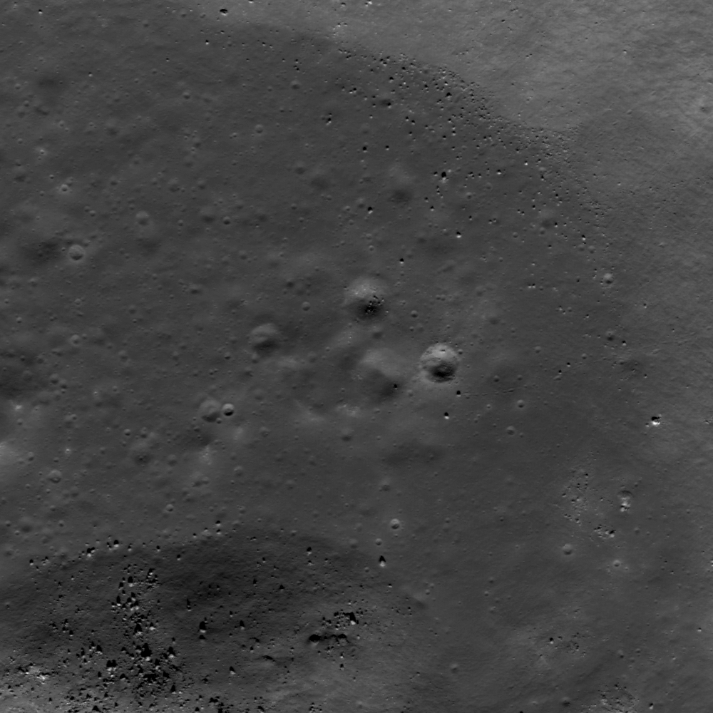
Blocks litter the interior floor of an impact crater in the north farside highlands terrain. LROC Narrow Angle Camera (NAC) frame M187357438LR, LRO orbit 12679, March 25, 2012; angle of incidence 52.19° - resolution 1.76 meters per pixel, field of view 1.81 kilometers from 180.37 km [NASA/GSFC/Arizona State University].
Lillian Ostrach
LROC News System

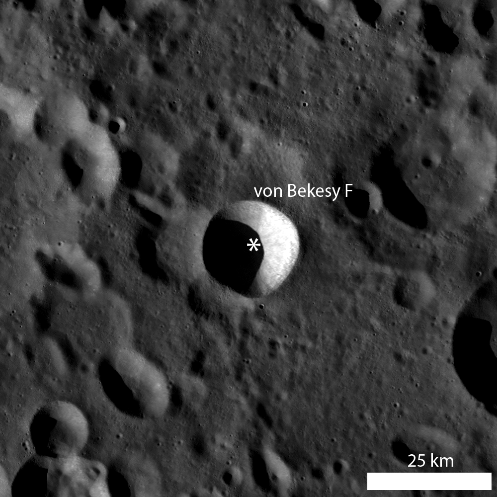
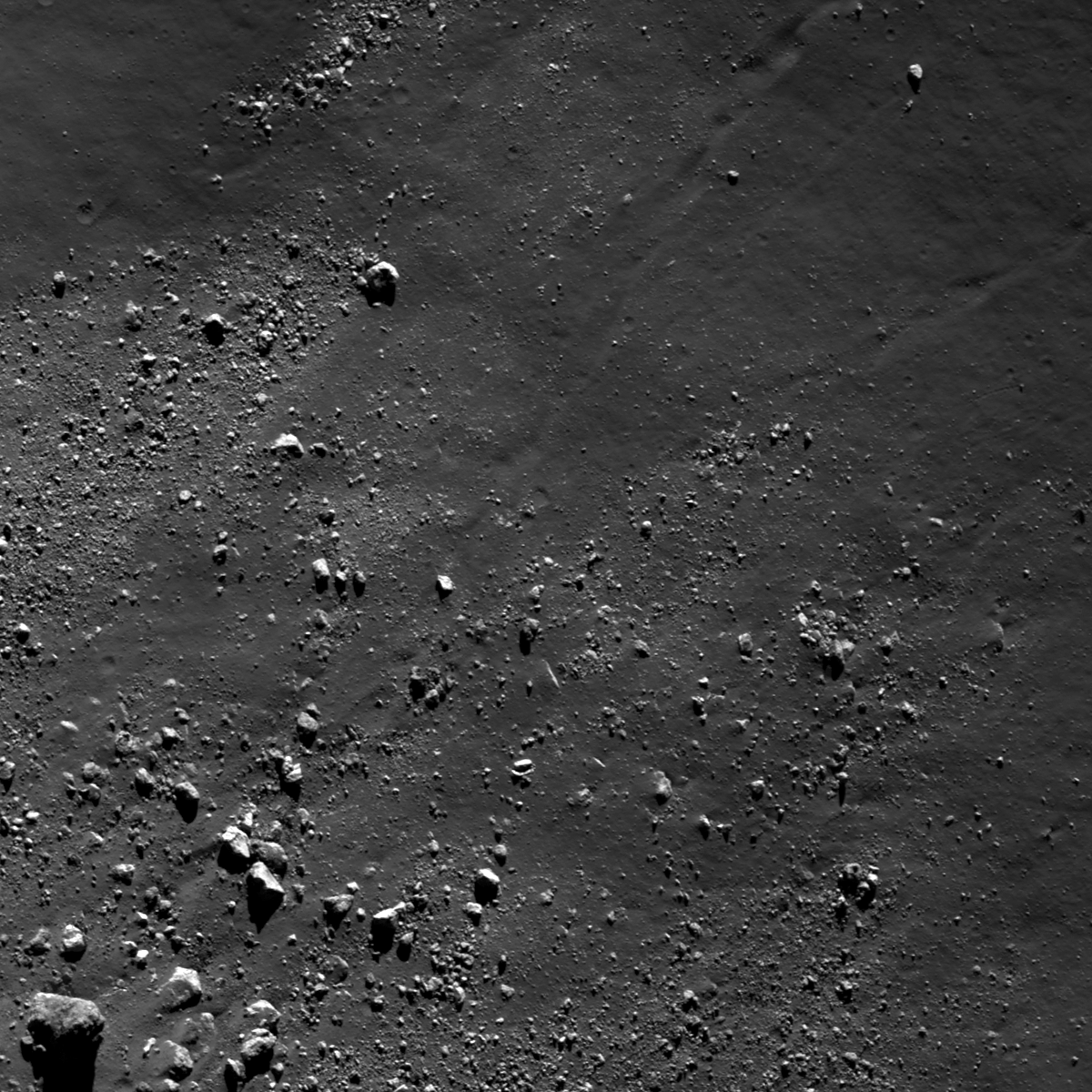
Blocks littering the floors of impact craters are evidence that erosive processes continue to act on the Moon. Blocks are distributed along the boundary between the crater walls and the floor of von Bekesy F (52.8°N, 137.04°E, 20 km diameter) and also surrounding mounds located on the crater floor. 

Today's Featured Image highlights boulders approximately 1 meter across eroding out of a floor mound and boulders that fell from somewhere along the crater wall or rim (52.86°N, 137.094°E). Observations of geologic relations between features are integral to developing a geologic story for an area, so it is important to make careful study of the different features. If we were to tell a story about the different boulders observed in the opening image, where should we start?

Interior view of von Bekesey F from 180 km, cropped from the full LROC NAC mosaic image [NASA/GSFC/Arizona State University].
There are clusters of blocky, fragmented material located on and surrounding the mound in the lower left of the opening image, and the boulders range from around 10 to 15 meters across. Observations of partially covered blocks on the mound support a mound origin. 

Similarly, the distribution of roughly 10 meters wide boulders at the contact between crater wall and floor suggests that these boulders probably fell from higher up on the crater wall. But what about the boulders in between the mound and the floor-wall contact? At least one boulder is located at the terminus of a trail that can be traced back to the crater wall, but there are no other apparent relationships linking boulder to their origin. 

LROC WAC monochrome mosaic centered on von Bekesy F crater, and asterisk notes location of opening image [NASA/GSFC/Arizona State University].
However, it may be possible that most of the boulders located in between the "boulder-rich" zones of the opening image originate from the crater wall side, simply because boulders falling from higher elevation will have a higher velocity component and will probably continue moving until the velocity and inertia components are lost (after the boulders hit the crater floor and begin to roll).

What do you think? Can you find evidence for boulder origin elsewhere in von Bekesy F in the full LROC NAC image, HERE?

Related Posts:
Perched boulders
Melt Boundary
Physics is Fun!

Tuesday, May 7, 2013

Boulder Tails

Boulders greater than 1 meter across, and a few trails, surround the base of a mountain in the Schrödinger central peak ring. Boulder in lower left is around 55 meters across; mountain base is beyond the frame to the lower left. LROC Narrow Angle Camera (NAC) observation M187340587LR, image field of view 732 meters, resolution 0.77 meters per pixel, angle of incidence 79.15° from 36.56 km  [NASA/GSFC/Arizona State University].
Lillian Ostrach
LROC News System

The Schrödinger impact basin is a geologically fascinating location, especially because of the variety of geologic features available for future exploration and it is the second youngest large basin on the Moon (just behind Orientale).

Discussed at length in several other Featured Image posts, blocky material, including boulders greater than 1 meter in diameter, can be used to help unravel geologic stories for an area.

In the case of boulders in Schrödinger, often the boulders originate from regions not easily accessible by robotic equipment or humans. Today's Featured Image highlights a distribution of boulders near the base of a part of the central peak ring (77.196°S, 133.178°E).

Context for the LROC Featured Image released May 8, 2013 - LROC Wide Angle Camera (WAC) monochrome (604nm) mosaic from 15 orbital passes, just after LRO completed its 10,000th orbit, September 3, 2011. Field of view (see section from mosaic below) roughly 50 km across [NASA/GSFC/Arizona State University].
LROC WAC mosaic covering a quarter of Schrödinger basin, show the 1400 meter high mountains rising over the mare-flooded interior contiguous with the greater peak ring structure [NASA/GSFC/Arizona State University].
Displaced fragmented blocks, such as those observed in the opening image, represent the movement of material from higher elevation to lower elevation. Most of the boulders range in size from ~15 to 25 m across, although the boulder in the lower left of the opening image is about 55 m across.

Today's boulders are derived from the higher elevations of a massif that is part of the Schrödinger central peak ring. Why is this fact geologically interesting? Because central peak rings form during the impact process; as the target is deformed and displaced during impact, material from depth is pushed toward the surface. Central peaks are usually formed in complex craters with diameters ranging from roughly 15 km to 200 km, but when the impact crater is larger than 200 km, central peak rings begin to form.

So, boulders originating from a central peak or central peak ring sample rocks from far beneath the lunar surface. How far? Scientists are not exactly certain, but there are several hypotheses and models undergoing testing with the help of LROC data.

HDTV still image captured from Japan's lunar orbiter SELENE-1 (Kaguya) in 2008. This oblique view was imaged as the vehicle orbited north, up over the Moon's farside from the far south [JAXA/NHK/SELENE].
Looking carefully, there is a boulder trail present (diagonally from lower left to upper right), and the boulder trail width is ~25 m near the upper right of the image. The irregular shape of the trail suggests that the boulder responsible for the trail was probably irregularly shaped. Additionally, the boulder trail is not discontinuous or "dashed", so it may be that the boulder responsible for the trail had a relatively low velocity. Similarly, there may be local slope variations in this area that promoted boulder rolling as opposed to boulder skipping.

Can you find a boulder that may be responsible for creating the observed boulder trail in the full LROC NAC image, HERE?

Related Posts:
A review of all things Schrödinger  
Craters on the Schrödinger pyroclastic cone
New 3D CLSE flyover video: Schrödinger basin
Sampling Schrödinger
Sampling a Central Peak
Perched boulders
Scarps in Schrödinger
LOLA: Schrödinger Basin