Showing posts with label Impact Melt. Show all posts

Tuesday, August 5, 2014

Fractures and boulders on the floor of De Forest

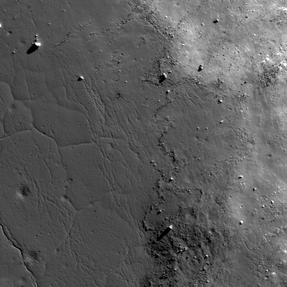
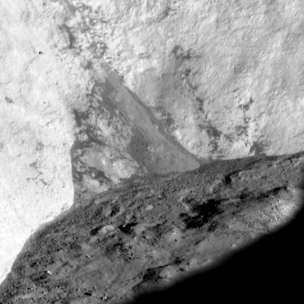
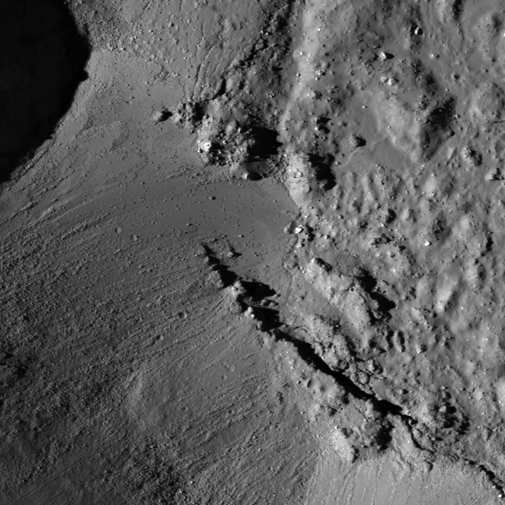
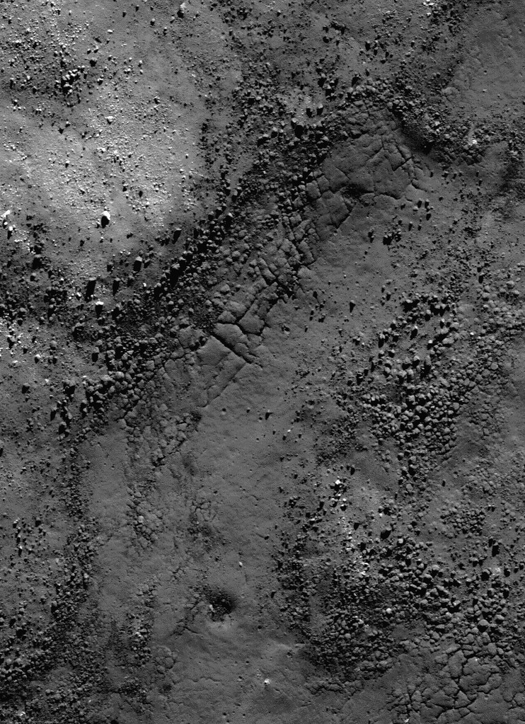
Fractured impact melt left the interior of De Forest crater (56.25 km; 76.94°S, 196.67°E) lined with boulders. 665 meter-wide field of view from LROC NAC observation M125650563L, 665 meter-wide field of view from LRO orbit 3650, April 11, 2010; 78.87° incidence angle, resolution 57 cm from 55.16 km over 77.1°S, 197.94°E [NASA/GSFC/Arizona State University].
Hiroyuki Sato
LROC News System

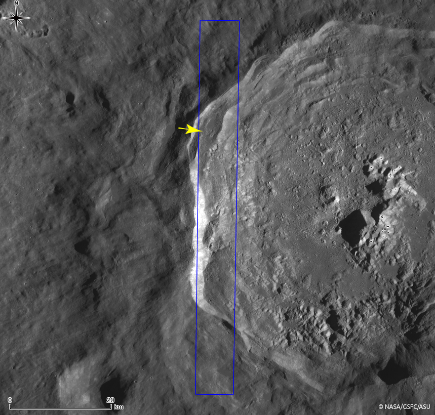
Today's Featured Image highlights a portion of the interior of De Forest crater (56.25 km; 76.94°S, 196.67°E), which is located inside the South Pole–Aitken basin.

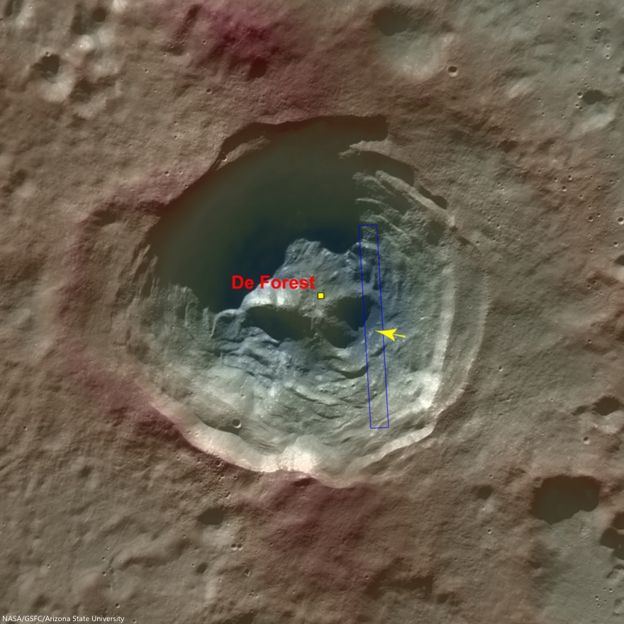
The cavity of De Forest crater exhibits prominent terraces of collapsed materials surrounding the central peak (see context imagery following).

The topographic low, east of the central peak, was largely coated with hot impact melt which formed a hard crust as it cooled; a portion of this melt is seen in the opening image. 

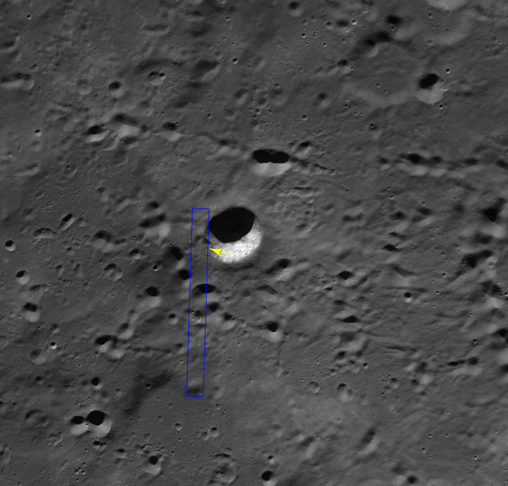
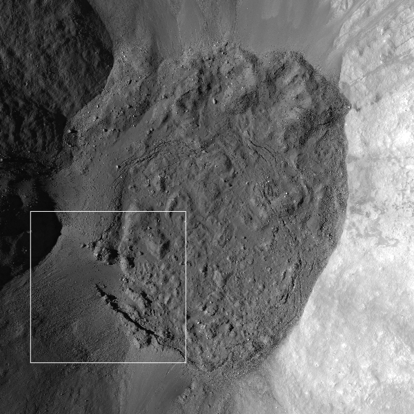
Context view of De Forest crater (56.25 km; 76.94°S, 196.67°E) consisting of LROC WAC monochrome mosaic (100 m/pix) overlain with colorized WAC stereo DTM (GLD100, Scholten et al., 2012). View centered on 76.92°S, 197.51°E. Footprint of LROC NAC observation M125650563L, April 11, 2010, outlined in blue, source of high-resolution view of the area designated with a yellow arrow (LROC Featured Image released August 5, 2014) [NASA/GSFC/Arizona State University]. 
Much of the area of the opening image is covered by numerous boulders, some of which are up to approximately 15 meters across.

The smooth surface extending in lower-left to upper-right is impact melt that cooled to form solid rock, and is now fractured in regular patterns along the edge. Impact melt that was splashed on the crater's walls and its central peak formed a coating that quickly cooled to solid rock.

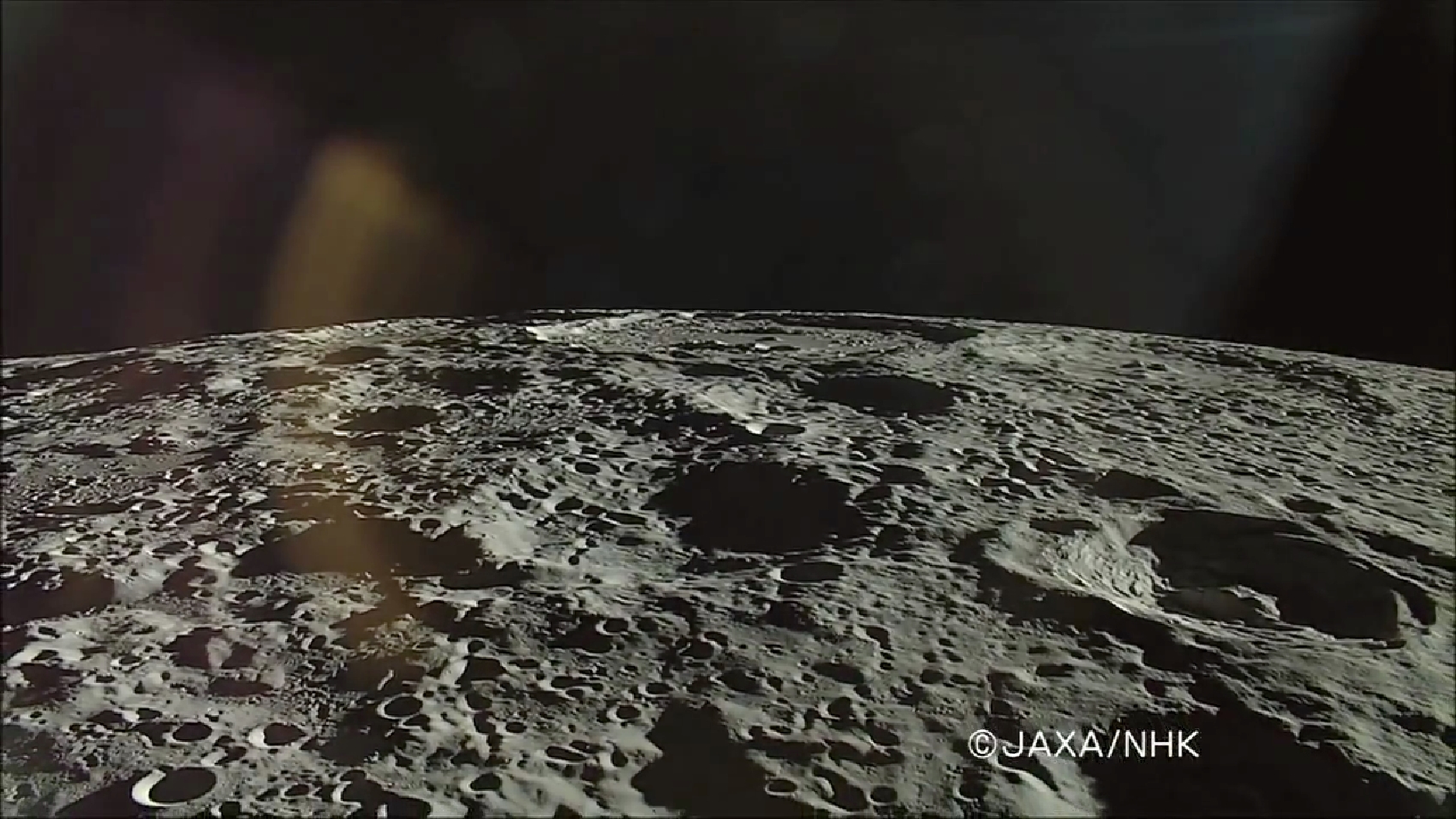
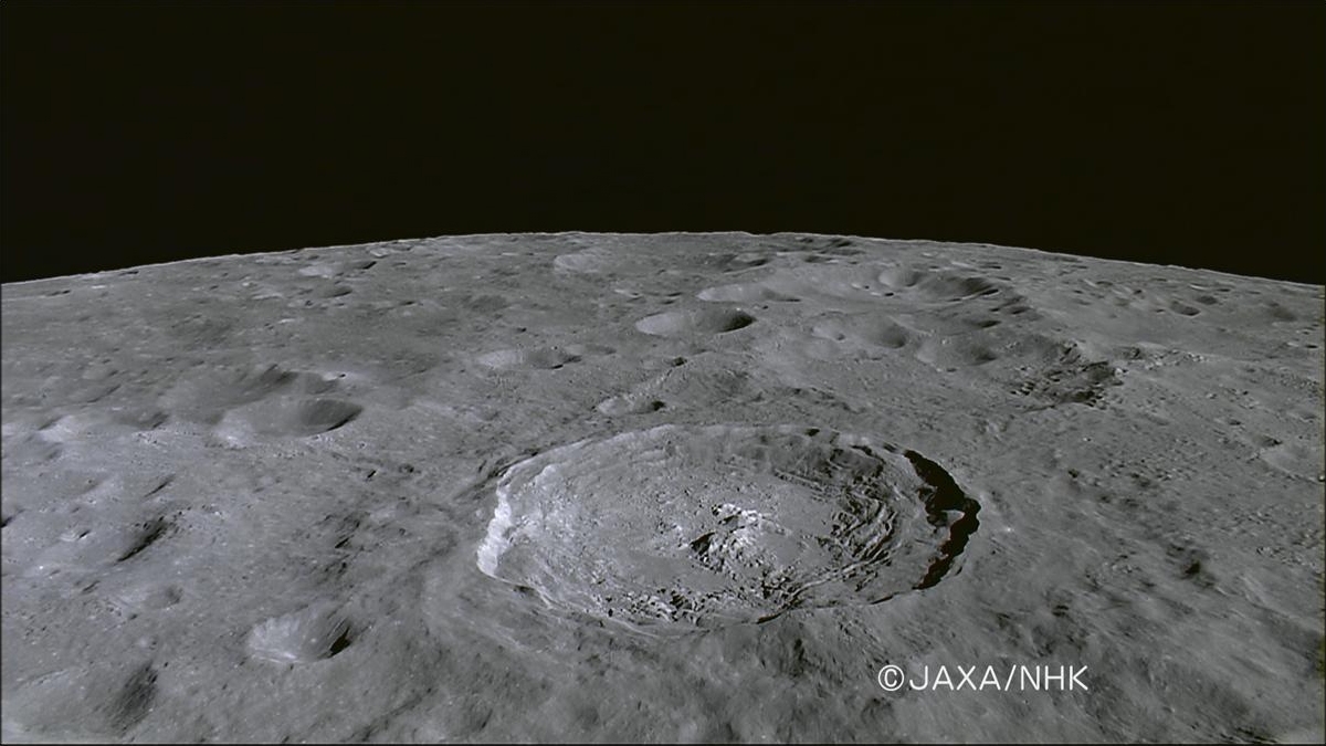
On the true "backside" of the Moon, De Forest (right) is situated well inside South Pole-Aitken impact basin, between Antoniadi (upper left, near horizon), host of the Moon's lowest elevation (-9094 meters) and Shackleton (not pictured), host of the Moon's south pole. HDTV still from Japan's lunar orbiter Kaguya (SELENE-1) in 2008 [JAXA/NHK/SELENE].
Later, it is likely that nearby moonquakes caused these brittle rock coatings to fracture, providing the source of boulders we now see on the lower reaches of the crater floor.

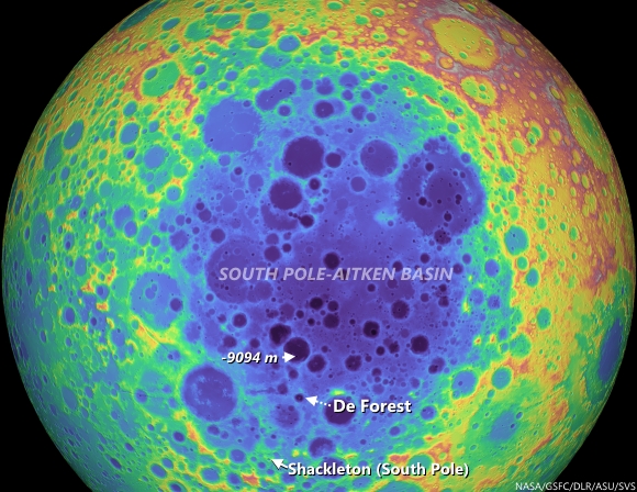
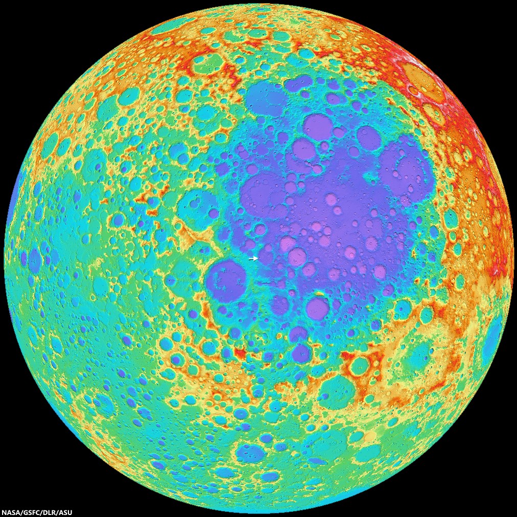
De Forest's position in the far south Farside is an area hosting Permanently Shadowed Regions (PSR's). The neutron detection experiment on-board LRO (LEND) has built up signatures consistent with cold-trapped volatiles, like water ice, in the vicinity. Image from Science Visualization Studio tour of SPA, larger image HERE [NASA/GSFC/Arizona State University/DLR/SVS]. 
As you can see in the following full NAC frame, an enormous number of similar boulders are found along the smooth melt deposits on the floor of De Forest crater. 

Explore this boulder-rich crater in the full NAC frame, HERE.

Related Posts:

Thursday, June 12, 2014

Study in superpositioning at Vavilov D

Sunrise, sunset. LROC NAC observations 10 months apart, one at local sunset and the other after local sunrise, both from nearly identical altitudes and resolutions, capture these views of double "dingleberries," drops of hot melt, very likely from the impact that created Vavilov crater, sit where they quickly flattened and cooled, just inside the steep slope of ancient Vavilov D. The Vavilov craters are a study in stratigraphy and superposition [NASA/GSFC/Arizona State University].
Immediately inside the northwest rim of highly degraded Vavilov D, twin disks of impact melt, likely from the formation of Vavilov, came to a standstill at the upper end of a contiguous slope of 5000 meters elevation, over about 40 km, into the complex floor of the latter Eratosthenian crater. This 1400 meter field of view (down slope is to the lower right, centered on 1.14°N, 221.536°E) from LROC NAC observation M1128031686L, LRO orbit 18385, July 9, 2013; 61° incidence angle, resolution 1.17 meters from 114.6 km [NASA/GSFC/Arizona State University]. 
Hiroyuki Sato
LROC News System

Vavilov D is an heavily degraded crater (96.1 km; 0.026°N, 220.93°E) sits between the Orientale basin and Jackson crater, both of which it may pre-date.

The later formation of the nearly identical, over-lapping Vavilov crater (98.2 km; 0.87°S, 221.23°E) eradicated the entire southwestern half of Vavilov D.

The second image above spotlights a spot on the northwestern curve of the wall of Vavilov D near where the Eratosthenian Vavilov erased the older crater's anatomy. The relatively smooth textured area in the upper left corresponds to the outside of Vavilov D, and the rest of rough/craggy surface is the interior crater wall's steep slope. 

The two degraded craters (~280 m in diameter) near the middle of the opening image exhibit fascinating overlying smooth features that may have formed as material flowed downslope (arrows).

View the full-resolution original HERE. The twin melt disks are located where the rim of Vavilov superseded that of Vavilov D, in the farside equatorial highlands,  where Vavilov is etched into terrain 8000 meters above the global mean elevation. It's possible an astronaut could walk from this location south into the interior of Vavilov. 5.6 km-wide field of view from LROC NAC observation M1128031686L [NASA/GSFC/Arizona State University].
Other morphologic pits/dents on this slope also have similar textures. What we are seeing here are most likely remnant impact melt that was thrown out of the Vavilov crater. Craggy sloped surfaces with patches of smooth material are often found associated with young impact craters -- formed as impact melt flowed over and around the newly formed crater.

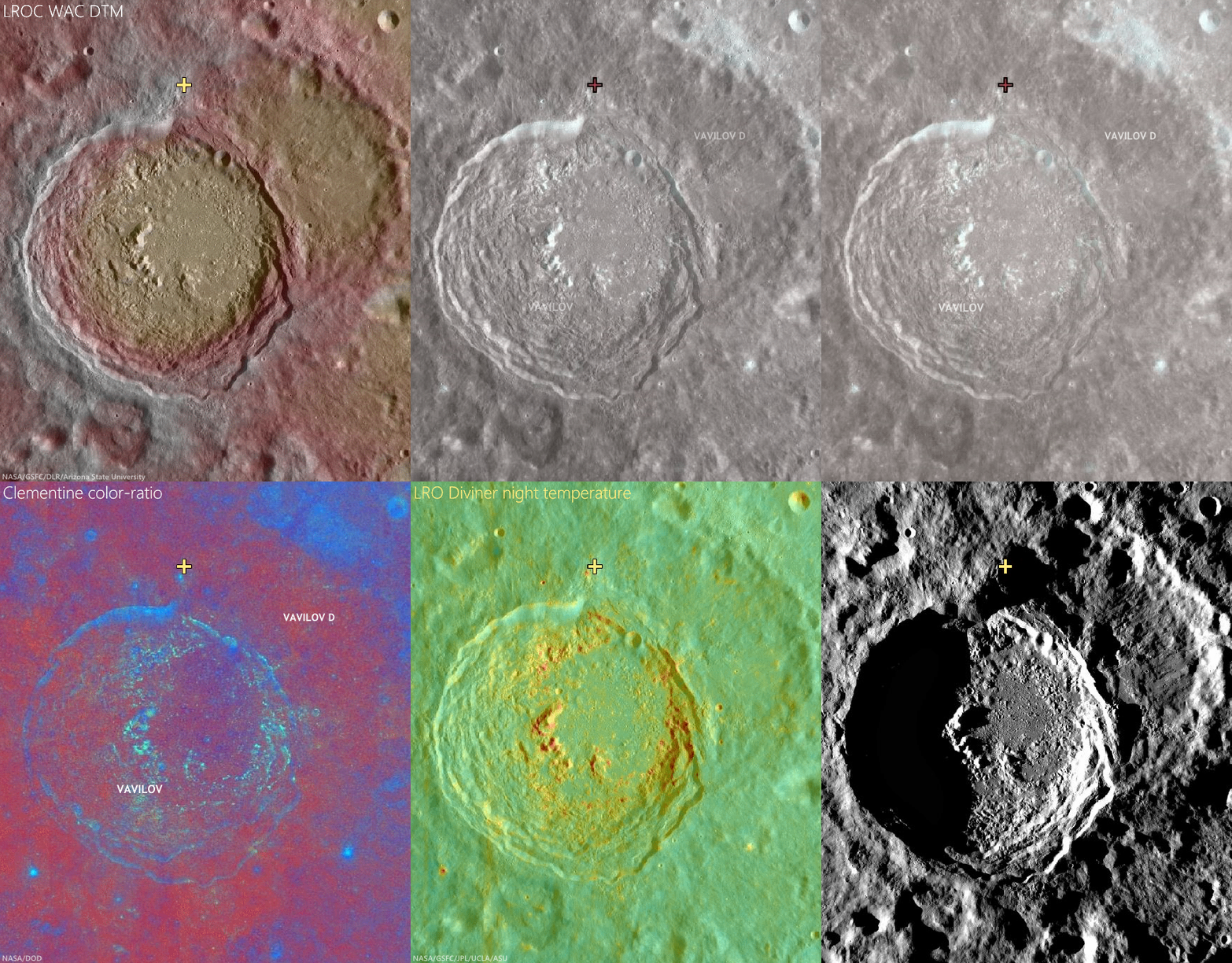
The deepest material brought to the surface by impacts on the Moon is found on the resulting crater's rim. A fresh crater near our area of interest, on the rim of Vavilov D (cross), exposes material excavated by that ancient impact, and Vavilov D, in turn, is nested on the Hertzsprung basin. The larger region is also at the outside range of the majority of secondary craters from the Orientale basin-forming impact. LROC Quickmap mosaic [NASA/GSFC/Arizona State University].
Depth of field in lunar photography is a fleeting quality. With the LROC WAC-derived elevation model (GLD100), however, the super-positioning of Vavilov D (and an aeon or two later, Vavilov) on Hertzsprung is much easier to detect, along with some of the most extreme elevation ranges, some 9 km above the global mean [NASA/GSFC/DLR/Arizona State University].
Related Posts:

Thursday, March 27, 2014

Distal Edges in the South Pole-Aitken basin

Blocky fences, like debris on a beach marking high water, border impact melt pools on the rim of an unnamed fresh crater on the vast floor of the ancient South Pole-Aitken impact basin, in jumbled terrain between Antoniadi and Schrödinger basin. 816 meter-wide field of view from LROC NAC observation M112884286R, LRO orbit 1759, November 15, 2009; resolution 66 cm per pixel, far south illumination incidence angle 75.9° from 63.93 km. The long axis of the large boulder at upper right is approximately 120 meters in length [NASA/GSFC/Arizona State University].
Hiroyuki Sato
LROC News System

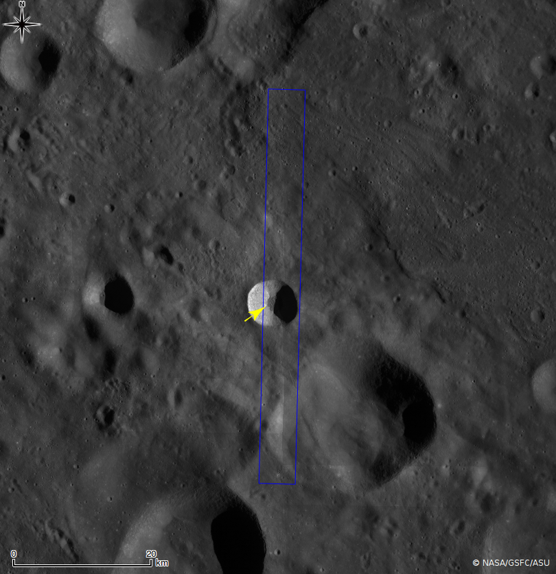
Today's Featured Image highlights striking forms on the outside rim of an unnamed young crater (~11 km in diameter; image center 71.425°S, 161.88°E; incidence angle is 75.9°) located 140 km east of Schrödinger basin.

The western flank of this small crater is dappled with multiple impact melt ponds (now solidified into rock) inhabiting local topographic depressions.

The surfaces of the ponds show polygonal patterns of fractures that likely formed as the melt cooled and solidified (and thus shrank). The organized pattern of boulders (looking somewhat fence like) formed along a flow front.

Since these lines of boulders rest on top of impact melt rocks they show that melt was splashed out at least two times during the crater forming event.

Context view of the unnamed 11 km-wide crater and vicinity. LROC WAC 100 meter monochrome mosaic, centered on 71.36°S, 162.91°E; field of view roughly 45 km. LROC NAC M112884286R footprint outlined in blue, location of the area of interest shown at high resolution, in LROC Featured Image released March 27, 2014 marked by arrow NASA/GSFC/Arizona State University].
The later splashes barely made it out of the crater and flowed only a short distance. What caused this last splashing of melt? Perhaps a large landslide on the interior wall fell into a lake of melt at the bottom of the crater and caused a big splash.

Short melt flows are common around lunar craters -- they tell a tale of the incredible forces unleashed during cosmic collisions. These same events happen as often on the Earth as the Moon. But why do we see so few impact craters on the Earth? Earth has a lot of resurfacing (erosion, weathering, volcanism, plate tectonics), and weathering or resurfacing on the Moon is a lot slower. Thus, more craters and melt deposits are preserved on the Moon.

The unnamed fresh crater between the deep crater Antoniadi and the Moon's youngest impact basin Schrödinger (edge at extreme lower left), on the vast floor of South Pole-Aitken basin, features terraced pools of impact melt more typical of much better known and studied craters, like Tycho, in the mid-latitudes of the nearside [NASA/GSFC/Arizona State University].
Enjoy the fascinating impact melt features around this young crater in full NAC frame, HERE.

Related Posts:
Tycho's flash-frozen inferno
Breached Levee
Splash Mark
Scalelike Impact Melts
Impact Melt Lobes
Herigonius K Impact Melt Flow
Waves

Situated between Antoniadi, home to a crater with the lowest elevation on the Moon, and Schrödinger basin, the fresh crater of interest is of an age and size (like similarly-sized and situated Shackleton) is generally more typical of mid-latitudes, a feature of the Moon's history of bombardment (and, thus, of the the Solar System) that's evidence of diminishing size and frequency of impacts over time, and more originating from the direction of the ecliptic. Exploration of the crater may afford an opportunity to sample deeper history. Hemispheric projection of LROC WAC-DTM topography centered on the area of interest [NASA/GSFC/DLR/ASU].

Thursday, January 9, 2014

Jackson's complexity

Frozen violence on the floor of Jackson
Solidified impact melt on the floor of farside crater Jackson, a silent testament to a violent impact event. LROC Featured Image, released January 9, 2014. 700 meter field of view from LROC NAC M1139975629RE, LRO orbit 20,065, November 24, 2013; native resolution 1.39 meters [NASA/GSFC/Arizona State University].
Raquel Nuno
LROC News System

The beautiful, jagged complex patterns seen on the floor of Jackson crater were formed when an asteroid slammed into the Moon at ~20 km/s (44,740 mph). This violent event likely occurred less than 500 million years ago, young by lunar standards.

Jackson crater is located on the farside of the Moon centered at 21.788°N, 164.92°W. This spectacular image was taken when the Sun was low on the horizon, causing dramatic lighting to accentuate the small topographical differences in the floor of Jackson crater. There are fantastic examples inside Jackson crater of the variety of morphologies that impact melt can produce.

Jackson crater, 72 km field of view
LROC Wide Angle Camera (WAC) context image for Featured Image released January 9, 2014. Dashed rectangle outlines LROC NAC observation M1139975629RE [NASA/GSFC/Arizona State University].
During an impact event, tremendous amounts of kinetic energy are transmitted from the bolide (comet or asteroid) into the target rock. Shock waves cause the rock to melt almost instantaneously! Most of this molten rock accumulates within the crater, but some can be ejected outside, and some flows back into the crater, in many cases freezing on the way down forming spectacular cascades. As the crater is forming, material from the crater walls slump into the still hot impact melt, creating a lumpy mixture of intact target rock and shocked target rock. The slumping of material causes the melt to slosh around, forming ripples and waves which then harden as the impact melt cools. Solidifying and cooling causes shrinkage and cracking in the rock.

Jackson crater (Kaguya)
Farside Copernican age landmark crater Jackson viewed through NHK's HDTV camera aboard Japan's lunar orbiter SELENE-1 (Kaguya) in late 2007 - enlarged 16:9 aspect HERE [JAXA/NHK/SELENE].
All of these impact features can be seen in today's Featured Image: impact melt ponds on terraced crater walls, impact melt channels, impact breccias, pressure ridges, and fractured melt sheets.

Can you find the different impact melt morphologies in the the full resolution NAC, HERE?

Related LROC Posts:
Channelized impact melt (August 13, 2011)
Waves (August 10, 2011)

Wednesday, November 13, 2013

Debris flow down the wall of Dugan J

M1131216329LR_thumb-1000x1000
Southeast wall of Dugan J, where material flowed downward and came to rest at the base of the crater wall. Field of view is approximately 2 km across. From LROC Narrow Angle Camera (NAC) mosaic M1131216329LR, an oblique observation swept up during LRO orbit 18833, August 15, 2013; resolution roughly 3 km per pixel [NASA/GSFC/Arizona State University].
H. Meyer
LROC News System

The farside crater Dugan J (roughly 13 km in diameter, 61.458°N, 107.898°E) is located northeast of Compton crater and well east of the marginally near-side Mare Humboldtianum.

Dugan J is a fresh, simple crater, which is why it appears crisply bowl-shaped and with steeply sloping walls in the LROC NAC oblique image, further below.

In that mosaic, notice the subtle surface expression of a filled crater in the foreground of the oblique image. This nearly 23 km diameter crater is almost unrecognizable because it is filled to the brim with ejecta from nearby impacts, including Dugan J. That's a lot of ejecta!

M1131216329LR-1600x736
Dugan J - In an oblique, relatively low resolution LROC NAC mosaic [NASA/GSFC/Arizona State University].
In the opening image, low-albedo material rests on the southeast wall. Unlike flows of liquid impact melt in craters, the flow observed above is composed of fine-grained, granular debris originating from the crater walls that acted like a fluid as it was pulled downslope by gravity.

Granular debris flows are common in fresh craters, where the walls are steeply sloping, promoting downhill movement of eroded material from high up on the crater walls to the crater floor. Over time, the walls degrade and shallow out. When their slopes reach the angle of repose (for the Moon: near 30° from horizontal), it becomes more difficult to move material downslope. However, if the slopes are disturbed by forces in addition to gravity, such as seismic shaking from a nearby impact, material can still be mobilized.

WMS-Dugan_J-context-580x902
LROC Wide Angle Camera (GLD100-WAC) mosaic showing Dugan J in context. The field of view from which the LROC Featured Image was cropped is designated by the yellow, dotted quadrangle, and two filled near-ghost craters are circled by orange circles. The black ellipse denotes the location of the Compton-Belkovich (Th anomaly) volcanic complex. Compton crater is approximately 164 km in diameter [NASA/GSFC/Arizona State University].
The granular flow appears to have originated from near the rim of the crater, where low-albedo material can be seen streaking the high-albedo crater wall. There is also some wall material external to the flow in Today's Featured Image that has been degraded and has started to cover part of the floor with rubble. The floor of Dugan J is covered in impact melt and blocks that are being worn into boulders.

Check out the full resolution NAC oblique image, HERE.

Related Posts:
Clerke crater (September 5, 2013)
Love U, on the farside of the Moon (June 26, 2013)
Rim Slumping inside pre-Nectarian Gamov (April 12, 2013)
Debris Flows in Kepler crater (February 6, 2013)
Debris flow at Clavius E: How Recent? (October 18, 2012)
Lunar landslides (October 15, 2011)
Top of the landslide of La Pérouse A (September 20, 2012)
Giant flow of Tycho impact melt (August 14, 2012)
At the top of an avalanche in Langrenus (October 7, 2011)
Dry debris or liquid flow? (June 3, 2011)
Impact melt at Epigenes A (October 24, 2009)

M169772751RE-NSJ-04-1-580x800
From a Draft Set of LROC NAC Debris Flow Images, a spectacular fresh landslide of exceedingly fine "fines," down the west-southwestern wall of Copernican crater Fechner T (58.7°S, 122.76°E). LROC NAC mosaic M169772751LR, LRO orbit 10153, September 4, 2011; 60° angle of incidence, resolution less than a half meter per pixel from 55 km [NASA/GSFC/Arizona State University].

Tuesday, October 22, 2013

Fractured melt rock on Jackson's terraced wall

M182253065R_1500
Close-up on fractured impact melt  ponding high on the west wall of Jackson crater. LROC LROC Narrow Angle Camera (NAC) M182253065R, LRO orbit 11965, January 26, 2012. Image 2130 meter-wide field of view centered on 22.534°N, 195.59°E, incidence angle is 57° at 1.47 meters per pixel resolution in the original [NASA/GSFC/Arizona State University].
Hiroyuki Sato
LROC News System

The opening image highlights a fractured pond of impact melt rock inside Jackson crater (72 km diameter). This prominent farside crater is known by its prominent ray system and large amount of impact deposits. Melt pooled not only at the bottom of the crater floor, but also on terraces of the interior wall.

The fractured melt sheet in the opening image is found amongst a grouping of melt lakes on a western crater wall terrace (see WAC context image below).

M182253065R_context
Western part of Jackson crater and surrounding areas in LROC WAC monochrome mosaic (100 m/pix). The NAC footprint (blue box) and the location of opening image (yellow arrow) are indicated [NASA/GSFC/Arizona State University].
Detached fragments from the main body of melt sheet look like a jigsaw puzzle (upper smooth surfaced portion of the image). These fragments give an impression of the thin and brittle nature of solidified impact melt. Shadow lengths show these fractured pieces to be 5 to 8 meters thick. What caused the once level and smooth ponded surface to fracture? We don't know for sure, but by looking at the whole area a plausible story can be imagined. The south part of the melt lake with the fractured plates is connected to another melt lake at a lower elevation. Perhaps drainage of subsurface unsolidified melt might have dragged a crust toward the south and broken the it into many blocky pieces. Tectonic deformation of the crater wall, perhaps consisting of whole terraces deforming, also might have occurred which could deform the brittle crust of melt ponds.

Jackson crater from Kaguya
Farside Copernican age landmark crater Jackson viewed through NHK's HDTV camera aboard Japan's lunar orbiter SELENE-1 (Kaguya) in late 2007. View the 1200 pixel-wide press release image HERE [JAXA/NHK/SELENE].
Explore this mosaic of fractured melt rock and surroundings to help unravel the complex history of Jackson crater in the full NAC frame HERE.

Related Posts:
Cracked mound (February 16, 2012)
Melt Fractures in Jackson Crater (January 20, 2012)
Tycho's flash-frozen inferno (November 2, 2011)
Waves (August 10, 2011)
Polygonal fractures on Tycho ejecta deposits (June 14, 2011)
Fragmented Impact Melt (February 25, 2011)
LOLA's Jackson crater (July 11, 2010)

Moore F Impact Melt (October 30, 2009)

Thursday, August 29, 2013

Rough crater wall surface

M182038126L_thumb-580x1000
Upper part wall inside an unnamed fresh crater in the southwestern quadrant of farside Hertzsprung basin. LROC Narrow Angle Camera (NAC) observation M182038126L, LRO orbit 11934, January 24, 2012; 56.41° angle of incidence, resolution 1.08 meters per pixel from 107.13 km. Downslope is toward lower right, north is to the top [NASA/GSFC/Arizona State University].
Hiroyuki Sato
LROC News System

The opening image reveals the northwestern portion of the steep wall inside an unnamed young crater (6.8 km in diameter, the same crater in Tuesday's Featured Image). The upper left corner of this image, the relatively smooth part, corresponds to the outer gently sloping surface, and the rest of the image is the interior wall.

This steep surface displays very complicated forms, likely due original flow of impact melt down the walls, perhaps in places modified by small scale collapses. Several spots indicated with arrows show the contact between relatively smooth surface materials, probably impact melts, and sharp craggy edges. Are the smooth parts really impact melt? Or perhaps they are surfaces from which hardened impact melt slipped down. What we do know is that enormous amounts of impact melt were splashed around inside and outside the crater, a violent scene we can hardly imagine. New LROC data is unveiling the nature of impact melts through their shape, texture, distribution, quantity, and spectral reflectance.

LROC WAC M112461899C (604nm) 580x1000
The unnamed crater and surrounding areas in the LROC Wide Angle Camera (WAC) monochrome (604nm) observation M112461899C, spacecraft orbit 1707, November 10, 2009; 39.1° angle of incidence, resolution 86.97 meters per pixel, from 61.69 km over 7.25°S, 227.53°E [NASA/GSFC/Arizona State University].
Explore this fresh and complicated crater wall in full NAC frame, HERE.

Related Posts:
Sinuous Cracks
View From The Other Side
Craggy Peak, Impact Melts
Cracked mound
Waves
Tycho Central Peak Spectacular!

Tuesday, August 27, 2013

Debris over impact melt pool

M182038126R_thumb-580
Debris avalanche covering an impact melt pond inside an unnamed crater floor. From LROC Narrow Angle Camera (NAC) M182038126R, LRO orbit 11934, January 24, 2012, centered on 4.135°S, 227.677°E, angle of incidence 56.58° over a field of view 1083 meters across, resolution 1.08 meters from 107.13 km. Downslope is toward upper right, north is to the top [NASA/GSFC/Arizona State University].
Hiroyuki Sato
LROC News System

Today's Featured Image highlights the southwestern edge of the floor of an unnamed crater (6.8 km in diameter), located in the SW corner of the degraded Hertzsprung basin (540 km diameter). The rough hummocky surface (upper right) corresponds to an impact melt pond, which covers the floor of this crater. The debris avalanches originated from the crater wall and covered the melt pond surface in the lower left. These debris deposits follow the topographic gap along a fracture extending to the lower right from the center of this image, indicating that the fracture formed before the avalanche.

M182038126R_NAC_context-600
The NAC frame as context for the LROC Featured Image (frame), showing the unnamed crater floor in Hertzsprung basin within a 3 km field of view [NASA/GSFC/Arizona State University].
Impact melt ponds usually develop fractures and deformations of their surfaces (e.g. Melt and more melt, Channels And Fractures). The cause and timescale of such modification is unclear and still under discussion (e.g. Ashley et al., 2012) but is likely due to the crater subsurface re-adjusting as the impact melt cooled and hardened. The shape of impact craters slowly evolves over long periods of time. Thanks to the relatively slow erosional processes on the Moon relative to the Earth, we can observe a series of craters from young to very old with NAC images, helping scientists understand the process of crater formation and subsequent modification. 

M182038126R_context-580x599
The unnamed crater and surrounding area in LROC Wide Angle Camera (WAC) monochrome mosaic (100 meter LROC Global Mosaic), centered on 4.02°S, 227.72°E. The NAC frame footprint and the location of Featured field of view are designated [NASA/GSFC/Arizona State University].
Explore the debris avalanche inside this young fresh crater in full NAC frame, HERE.

Related Posts:
More Impact Melt!
The View Inside of a Tilted Crater
Schiaparelli E
Channels And Fractures
Impact melt outside Wiener F
Rippled Pond
Melt and more melt
Vavilov-Hartzsprung-LROCDEMCSHd-064-969
Color shaded LROC digital elevation model shows the small crater in starker contrast not readily visible in pure optical photography (arrow, right of lower center), in the ancient Hertzsprung basin and nearby Vavilov crater. 400 km field of view, orthographic projection from LROC WMS image search map [NASA/GSFC/Arizona State University].

Wednesday, July 31, 2013

Melted Moon

Click for full resolution LROC mosaic
The fresh lunar crater Giordano Bruno -a wealth of fascinating landforms to study. (click image for full resolution view, or HERE for a wider, medium resolution field of view showing the entire crater) [NASA/GSFC/Arizona State University].
Paul D. Spudis
The Once and Future Moon
Smithsonian Air & Space


Prior to the Space Age, one of the longest running controversies in lunar science was over the origin of the Moon’s craters.  Two camps emerged, one favoring an internal (volcanic) origin and the other an external (impact by solid bodies) origin.  Although this debate was finally resolved in favor of impact, the argument was long and vehement, reigniting at one point during the flight of the last of the robotic precursor probes to the Moon, prior to the Apollo landings.  Although the basic physics of impact were well understood by the mid-1960s, this newest argument centered around high-resolution pictures obtained by Lunar Orbiter 5 (1967) of the fresh (and therefore young) crater Tycho.  These spectacular images showed a multitude of flows, smooth ponds, and fluid rock, seemingly draped over hills and hummocks (like a chocolate shell coating over a scoop of ice cream).

An asteroid possesses an enormous amount of kinetic energy when it strikes a planetary body at very high speeds.  On contact, the asteroid vaporizes and the surface target rocks are intensely compressed.   After the shock wave has passed, these rocks decompress and the release of this energy totally melts part of the crustal target.  This material is said to be shock melted, with the resulting liquid called impact melt.  Impact melt was first described from craters on the Earth, particularly some of the very large impact craters found on the ancient Canadian Shield.  These rocks superficially resemble some volcanic rocks, having both fine-grained textures and partly melted inclusions.  But unlike volcanic rocks, they have high concentrations of siderophile (“iron-loving”) elements, such as iridium.  These elements are extremely rare in the Earth’s crust, but are more abundant in meteorites and asteroids.  It is thought that they are added to the melt from the incoming projectile.

The newest chapter in the argument about the origin of craters came about because some landforms around Tycho look similar to small-scale volcanic features on Earth.  The idea proposed was that the craters had been formed by impact, with those collisions triggering volcanic activity and producing multiple episodes of eruption at Tycho and other craters.  At first glance, such a scenario seems plausible.  After all, impact is a catastrophic event and one can imagine churning seas of subsurface liquid rock, released suddenly through the creation of fractures deep in the crust.  But the Moon’s interior is relatively cool.  If interior melt exists, it is at a level much too deep for any reasonably sized impact to tap.  But these amazing landforms needed to be explained.  What might they represent?

We found abundant physical and chemical evidence for impact (including shock-melted rocks) by studying the Apollo samples.  They appear similar to volcanic lava, with inclusions, melt textures and even vesicles (holes), comparable to the ones produced by magmatic volatiles coming out of solution in basaltic lavas on Earth.  Although it took a bit of study (and many more arguments) to establish their origin, shock melting became recognized as an important lunar (and Earth) impact process.

M160029952LR-109-1160x1600
Breech in the northwest rim of Tycho connects to the spectacular melt ponds inside out outside of the 109 million year old landmark crater. Illustration originally from "Landing Site at Tycho North," March 20, 2013 [NASA/GSFC/Arizona State University].
The images of the flows and ponds seen around Tycho and other fresh lunar craters led to a better understanding of how these rocks formed.  Although we knew about impact melting from the study of Earth’s craters (and had found evidence of the same in lunar samples), some researchers still weren’t convinced that we were seeing flows of liquid impact melt on the Moon.  The leading non-volcanic alternative was that these features were flows of dry, fine-grained granular debris.  In part, this interpretation proceeded from the observation that the thermal signatures of some of these melt-like flows suggested the presence of fine debris rather than bare, jagged rock.  Yet other data, such as radar backscatter, suggested that rough surfaces were common, while extremely high-resolution images showed abundant blocky craters on the surfaces of the flows, suggesting they were composed of solidified rock.

Landing site of Surveyor 7 (arrow) in relation to it's hoped for target, the kilometer-sized impact melt pond immediately to the northeast, part of the spectacular melt throughout the vicinity of Tycho [NASA/GSFC/Arizona State University].
Images from the robotic Surveyor 7 (1968) spacecraft, which landed on the rim of Tycho, revealed the thinnest regolith (soil) covering of any site on the Moon.  Visible in the surface panoramas were flow features covering the distant hills.  It took a great deal of painstaking, detailed work to establish that these flows and ponds were composed of liquid rock, created simultaneously with their host crater and likely originated by impact melting and subsequent solidification.

For the last several years, NASA’s Lunar Reconnaissance Orbiter (LRO) has been sending us new and astonishing views of the Moon’s impact melt flows.  Whereas fresh craters like Tycho, Aristarchus and Copernicus were well known from previous Lunar Orbiter frames, far side craters like the spectacular Giordano Bruno can now be seen with incredible clarity.  G. Bruno is one of the very youngest craters on the Moon.  A low density of craters overlying G. Bruno suggests an age of less than a couple million years (extremely young on a planet where most features count years in the billions).  It is an astonishing spectacle of melt shapes and deposits (cracked floors, pools, flow festoons and lobes); the crater floor has an amazing whirlpool of solidified melt. All these features indicate that after the crater formed, the impact melt was mobile, flowing and collecting, and ponding in low areas.

Impact melt forms a swirled feature in Giordano Bruno crater. Field of view 1 kilometer. From LROC Narrow Angle Camera (NAC) observation M143947267L LRO orbit 6347, November 9, 2010; 53.08° angle of incidence, 57 centimeters per pixel resolution from 54.50 km. Illustration from "Giordano Bruno Whorl," June 8, 2013 [NASA/GSFC/Arizona State University].
Impact melts are of great interest to geologists.  Unlike other crater ejecta, the radiometric clocks of impact melts are completely re-set by the melting.  Thus, if a sample can be obtained first-hand, directly from an observed flow or pool of melt around a host crater, the age of that rock specifically and unambiguously dates the impact event.  Unfortunately, we did not visit such deposits during the Apollo explorations.  What we do have are loose samples of lunar impact melt but not their scientifically important corresponding geological context.  It is for this reason that the age and sequence of early lunar history is so contentious – we must make educated guesses about where certain melt rocks come from.  If we get the context wrong, then our conclusions about the history of the Moon are incorrect.

Increased understanding of the generation and deposition of impact melt comes from the new images obtained by the LRO camera of the geologic setting of impact melts.  Future sample return missions to the Moon can be directed to landing sites that will provide us with samples of clear geological context (that they were from that area and not just flung there by an impact occurring elsewhere on the lunar surface).  As features age on the Moon, subsequent geologic events (such as superposition of new units) bury or erase the original event making the context less clear.  This problem is particularly acute for the oldest features on the Moon (multi-ring impact basins).  By studying the geology of the freshest lunar features (such as Tycho and other fresh craters), we understand how the older impact features looked immediately after their formation.  Thus, they serve as a guide to the interpretation of the older features.  On the Moon, as on the Earth, as Charles Lyell, the 19th century author of the classic Principles of Geology aptly put it:  The present is the key to the past.

Collection of spectacular impact melt features from LRO:
Giordano Bruno high-resolution full view
G. Bruno sunset
G. Bruno flows
G. Bruno cracked melts
Tycho oblique
Tycho floor
Tycho river of rock

Originally published July 31, 2013 at his Smithsonian Air & Space blog The Once and Future Moon, Dr. Spudis is a senior staff scientist at the Lunar and Planetary Institute. The opinions expressed are those of the author but are better informed than average

Tuesday, July 23, 2013

The View Inside a Tilted Crater

Oblique view of the chaotic interior of 30-km Wiener F crater. LROC Narrow Angle Camera (NAC) mosaic M1113262343LR; LRO orbit 16307, January 19, 2013, spacecraft and camera slewed 52° west from 160.39 km over 41.84°N, 140.28°E, subsampled from a scaled 2.78 meter per pixel resolution. Scene width approximately 13 kilometers from left to right, centered at 41.1°N, 150.0°E. [NASA/GSFC/Arizona State University].
Brett Denevi
LROC News System

Impact melt is commonly found in and around fresh lunar craters and can be spotted as ponds, flows, and ejecta.

This oblique view of the farside crater Wiener F highlights one of the more spectacular examples of what happens to the melt when a crater forms on a slope.

In the image above, you have a great perspective view of the chaotic crater interior, where material slumping into the crater interacted with the fluid melt, creating rough, hummocky mixtures in some regions and smoother pools of melt in others. But what is really interesting about this crater becomes clear when you zoom out to the full width of the image, below.

Thumbnail view of LROC NAC mosaic M1113262343LR, looking from west to east into Wiener F crater. For the full-resolution, zoomable view click HERE [NASA/GSFC/Arizona State University].
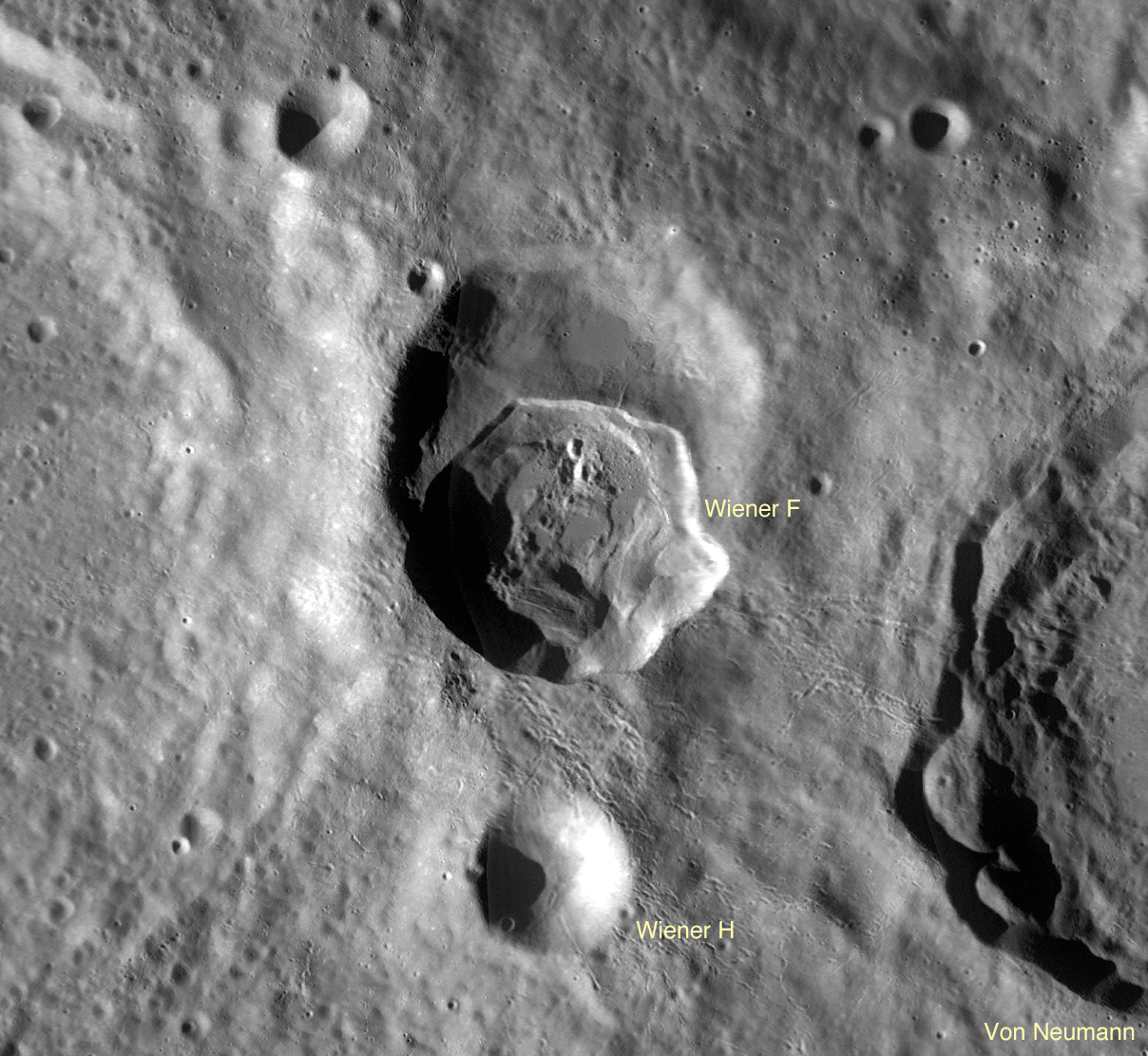
Wiener F formed atop a larger, older crater, so its northern rim, on the left in the picture above, ended up substantially lower than the southern rim. A profile across the crater, taken from the GLD100, shows the northern rim of the crater is over 2 km lower in elevation than the southern rim!

A profile from south to north across crater Wiener F, taken from LROC WAC-derived topography data [NASA/GSFC/Arizona State University].
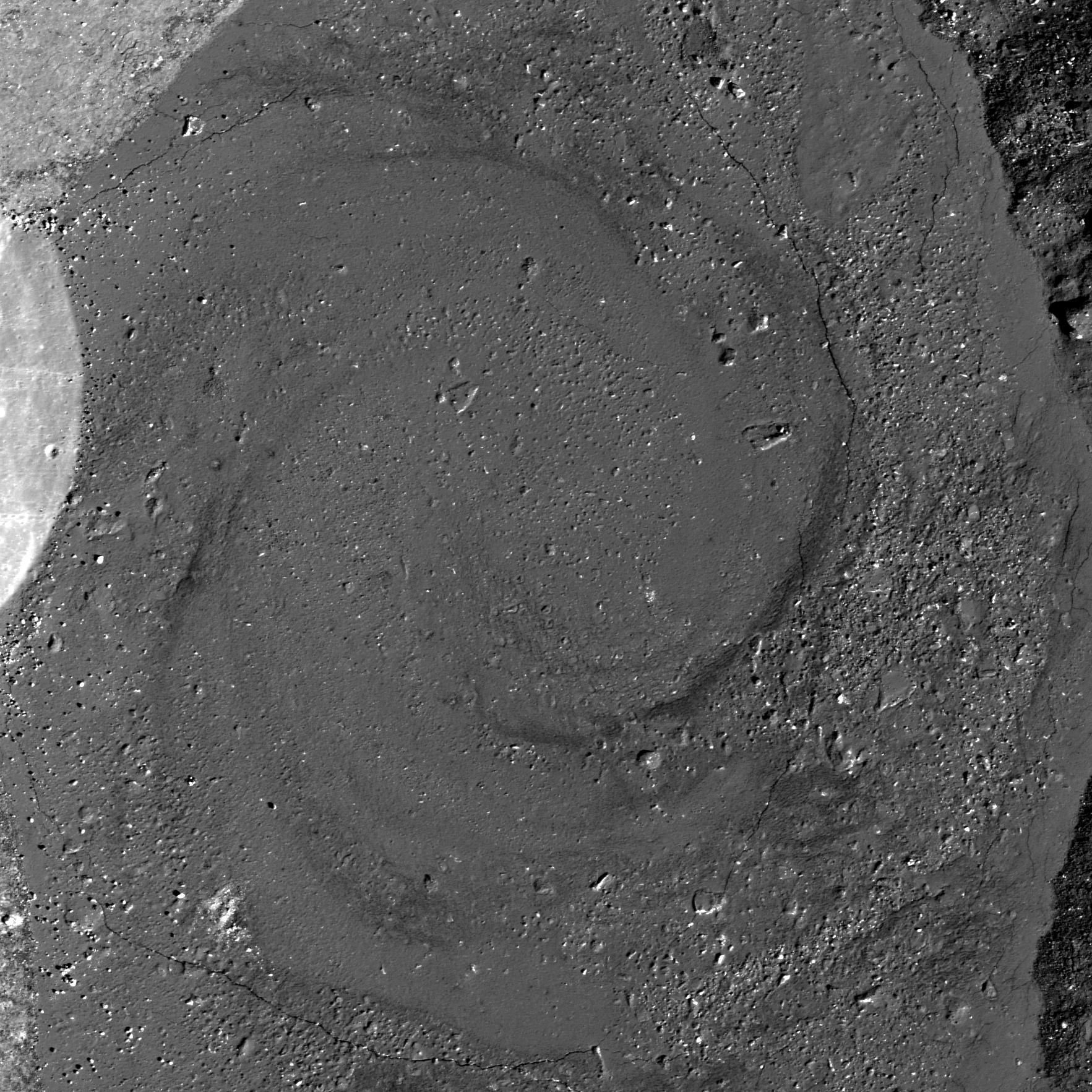
So tilting the crater like this is like tilting a glass of water - it spills. In this case, the hot impact melt that would normally stay within the crater poured out, spilling over the northern rim and pooling outside the crater. Click on the image below to see this spectacular flood. You can find individual flows and places where the melt was still moving even as a crust of hard rock formed on top, resulting in cracks and wrinkles in the top layer.
View of the impact melt that escaped Wiener F, pooling outside the northern crater rim. Image subsampled from the original resolution [NASA/GSFC/Arizona State University].
Impact melt is a favorite target for LROC imaging because of its often complicated and bizarre features, and because of what it tells us about the impact process. The volume of melt can give clues as to how fast an impactor hit the surface (higher velocities mean higher shock pressures and more heat to melt rock), at what angle it impacted (melt is often thrown downrange of an impact), and how long ago the impact occurred (by observing how well preserved the melt morphology is, or by age-dating a sample of melt). Impact melt can also give insights into how portions of the crater moved and settled as the crater formed (for example, how did melt get up HERE?).

LROC Wide Angle Camera (WAC) contextual view of Wiener F crater, nested in the Farside Highlands [NASA/GSFC/Arizona State University].
Wiener F is another piece of that puzzle, showing what a dynamic environment an impact crater is shortly after formation. Click HERE for the full-resolution view of Wiener F.
Other Spectacular
Impact Melt Favorites:
Rumker E Impact Melt
Dynamics of Molten Rock
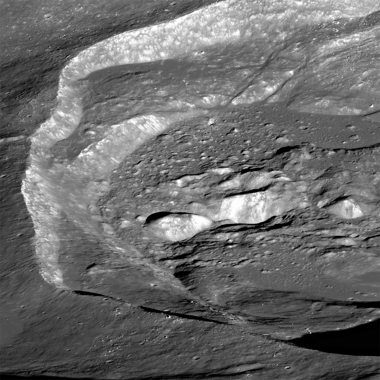
La Pérouse A Impact Melt
Rippled Pond
Breached Levee
Secondary Melt on the rim of Wiener F
Getting cracked in Wiener F
Giordano Bruno Whorl

Saturday, June 8, 2013

Giordano Bruno Whorl

Impact melt forms a swirled feature in Giordano Bruno crater. Field of view 1 kilometer. From LROC Narrow Angle Camera (NAC) observation M143947267L LRO orbit 6347, November 9, 2010; 53.08° angle of incidence, 57 centimeters per pixel resolution from 54.50 km [NASA/GSFC/Arizona State University].
Sarah Braden
LROC News System

The crater Giordano Bruno (22 km, 35.97°N, 102.89°E) is a favorite of lunar scientists due to its relatively young age and the amazing impact melt features found within and without the crater walls.

Previously, the LROC Featured Image gave a birds eye view of the whole crater in "Giordano Bruno, The Big Picture."

Today's Featured Image uses a 57 cm per pixel NAC frame to highlight the details of a giant swirl (or whorl) of impact melt within one of the larger impact melt pools inside Giordano Bruno.

M1102880536LR-NSJ-0110-58b-9587x13223
Under a much higher Sun, a lower angle of incidence, the 'whorl' (left of center, at the contact between the west crater wall and floor) can also be seen in this mosaic showing nearly the entire complex melt flows and interior of Giordano Bruno. View the full resolution (9587x13223) mosaic, HERE. LROC NAC mosaic M1102880536LR, orbit 14851, September 21, 2012; 37.55° angle of incidence, resolution 1.52 meters from 152.11 km [NASA/GSFC/Arizona State University].
The whorl formed in a clockwise direction and is about 1 kilometer in diameter. This spiral-shaped feature may have formed due to shear stress created when molten impact melt flowed at different speeds (probably caused by drag from the pool floor or an obstacle within the pool). This shear would modify flow directions in ways that could ultimately produce such a swirling pattern. Slumping material may have set the melt into motion within an otherwise calm impact melt pool.

hdtv_008_5_l
Giordano Bruno from south, looking ahead from Japan's Kaguya (SELENE-1) in polar orbit (2008), from roughly 100 km over the 102nd meridian. The crater is closely studied because it is strikingly fresh, perhaps less than 10 million years old and far less affected by the steady gardening of micrometeorites and the steady rain of energetic cosmic rays that turn over the top 3 mm of the Moon's surface every 2 million years [JAXA/NHK/SELENE]. View the full 1920x1200 original, HERE.
The more information lunar scientists can gather about how quickly impact melt cools, the more we will know about how this structure formed!

Explore the entire NAC frame for more amazing views of Giordano Bruno, HERE.

Related Images:
Very Oblique View of Giordano Bruno
Sunset Over Giordano Bruno
Outside of Giordano Bruno
Fragmented Impact Melt
Impact Melt Flows on Giordano Bruno