Showing posts with label Mare Serenitatis. Show all posts

Friday, July 18, 2014

Dorsum Nicol

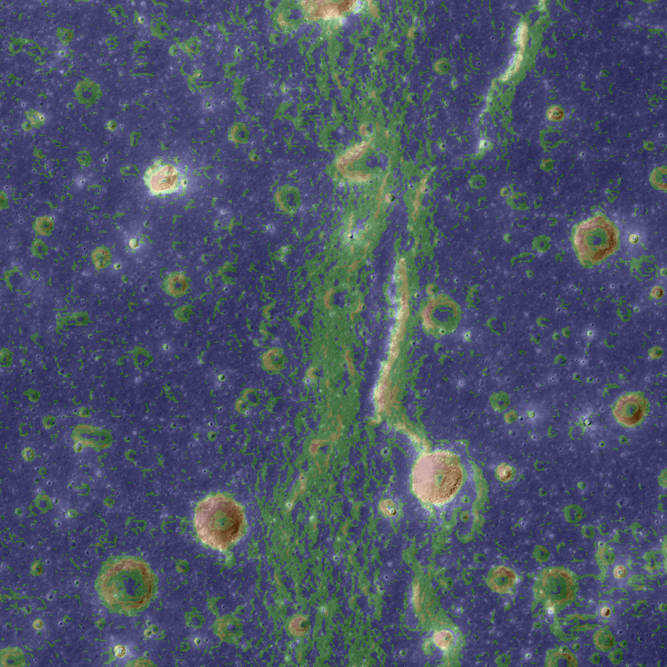
This tectonic feature was formed as stresses built up in the lunar surface until it gave way. The energy released was immense, and the displaced rock is the north-south trending wrinkle ridge seen today in southeast Mare Serenitatis. LROC NAC-derived digital terrain model, slope angle and recent imagery. Field of view is 4765 meters across [NASA/GSFC/Arizona State University].
Aaron Boyd
LROC News System

Dorsum Nicol is a wrinkle ridge found in southern Mare Serenitatis.

The opening Featured Image is a LROC NAC image, juxtaposed with a slope map, NAC-derived DTM and recent LROC NAC observation of area.

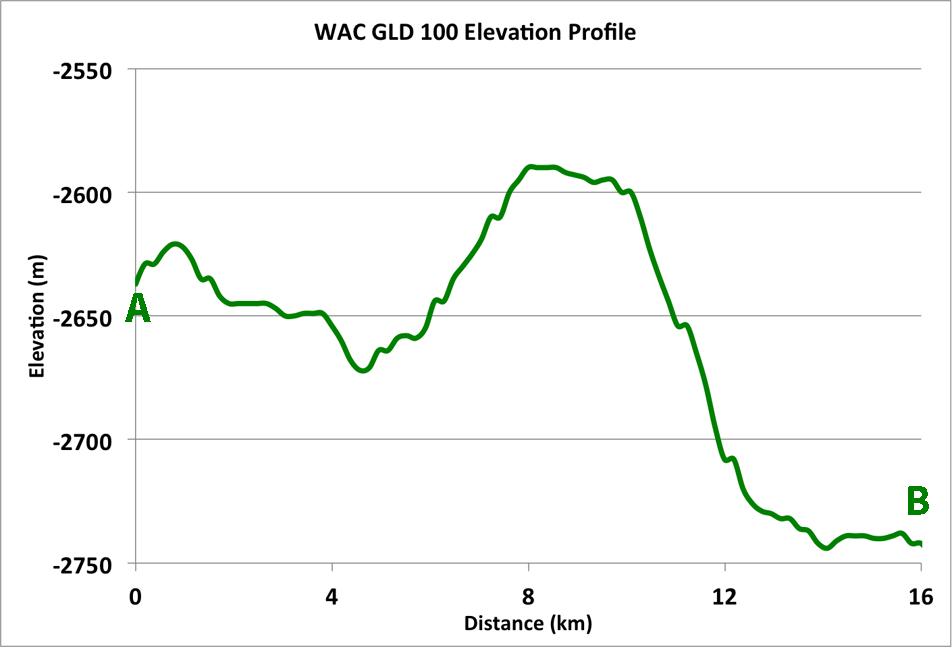
Slope maps are useful to planetary scientists because topographic features like craters and small ridges really stand out. At the  location in the LROC Featured Image field of view, the mare on the west side of the ridge is about 100 meters higher in elevation than the mare on east side of the wrinkle ridge, and the peak elevation is around 50 meters above that (see profile below).

Elevation profile across Dorsum Nicol, at field of view for LROC  Featured Image released July 17, 2014. (Points A and B correspond to A and B in LROC WAC context image, below [NASA/GSFC/Arizona State University].
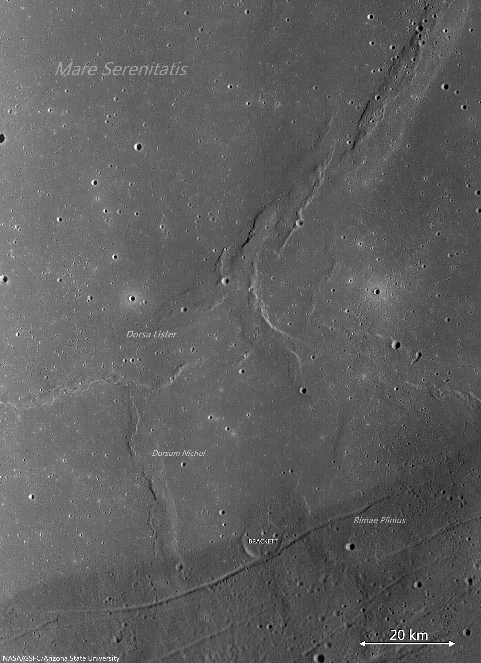
The difference in elevation between the eastern and western flanks of the ridge could be due to the lunar surface buckling and folding beneath the surface, or it could be from mare fill after the wrinkle ridge was formed.  Dorsum Nicol has a width of 10 km at its widest and 5 km at its narrowest. Take a look at the full feature in the context image below.

LROC WAC context image of Dorsum Nicol in Mare Serenitatis. The yellow box is the approximate location of today's Featured Image, the red box is the location of the full NAC DTM. A profile taken along the white line from A to B and is shown above. Context image spliced from LROC Wide Angle Camera (WAC) monochrome (604 nm) mosaic of three observations swept up over three sequential orbital passes (LRO orbits 9031-9033) June 8, 2011; incidence 75.86° resolution 58 meters from 42 km [NASA/GSFC/Arizona State University]. [NASA/GSFC/Arizona State University].
Wrinkle ridges are are surface expressions of compressional forces being released; they are seen in all large maria on the Moon. The loading from the massive flood basalts during mare volcanism could have caused the lithosphere to flex because the density of the flood basalts is higher than the anothositic highlands material. Buoyancy forces were at work here, causing viscoelastic relaxation and inducing forces in the mare rock.

Full-sized LROC WAC mosaic, from three sequential passes June 8, 2011. See full size mosaic HERE [NASA/GSFC/Arizona State University].
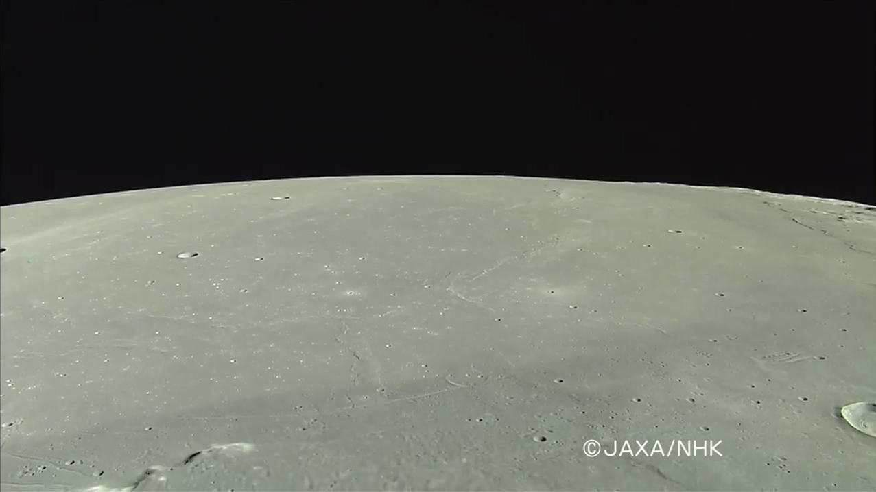
Southwestern Mare Serenitatis in HDTV. Dorsum Nichol (next to the ghost crater Brackett, butted up against Rimae Plinius, together with Dorsa Lister, and in the foreground, the belt of darker basalts encircling the entire impact basin, Rimae Plinius and Promontorium Archerusia are at lower left, a view Harrison Schmitt describes as close to what Apollo expeditions saw in orbit. From a HDTV still, captured from Japan's lunar orbiter Kaguya (SELENE-1) in 2008. See the original release image HERE [JAXA/NHK/SELENE].
These forces caused the once convex surface of the maria to become more planar as time went on. This is a problem because a plane has less area than a curved surface when they are bounded by the same radius. Where was the rock going to go? Well, the maria resisted this change in topology until something broke! Wrinkle ridges are the expression of that thrust fault behavior.

Locating Dorsum Nicol in southeast Mare Serenitatis is easier than actually seeing these features, through a modest telescope. The stacked photograph above, assembled by Astronominsk in Minsk, Belarus, was captured at the best illumination incidence for such a purpose, on June 28, 2009, right after local sunrise, before First Quarter (in an early evening sky, here on Earth). Locating Taurus Littrow valley, the landing site of Apollo 17, and Promontorium Archerusia, along with other features in the contact area between Mare Serenitatis and Mare Tranquillitatis are relatively easy, however, throughout the lunar day [Astronominsk].
Check out the full NAC frame on the the LROC DTM product page, HERE.

Related Posts:

Wednesday, January 9, 2013

Boulders In the Sea of Serenity

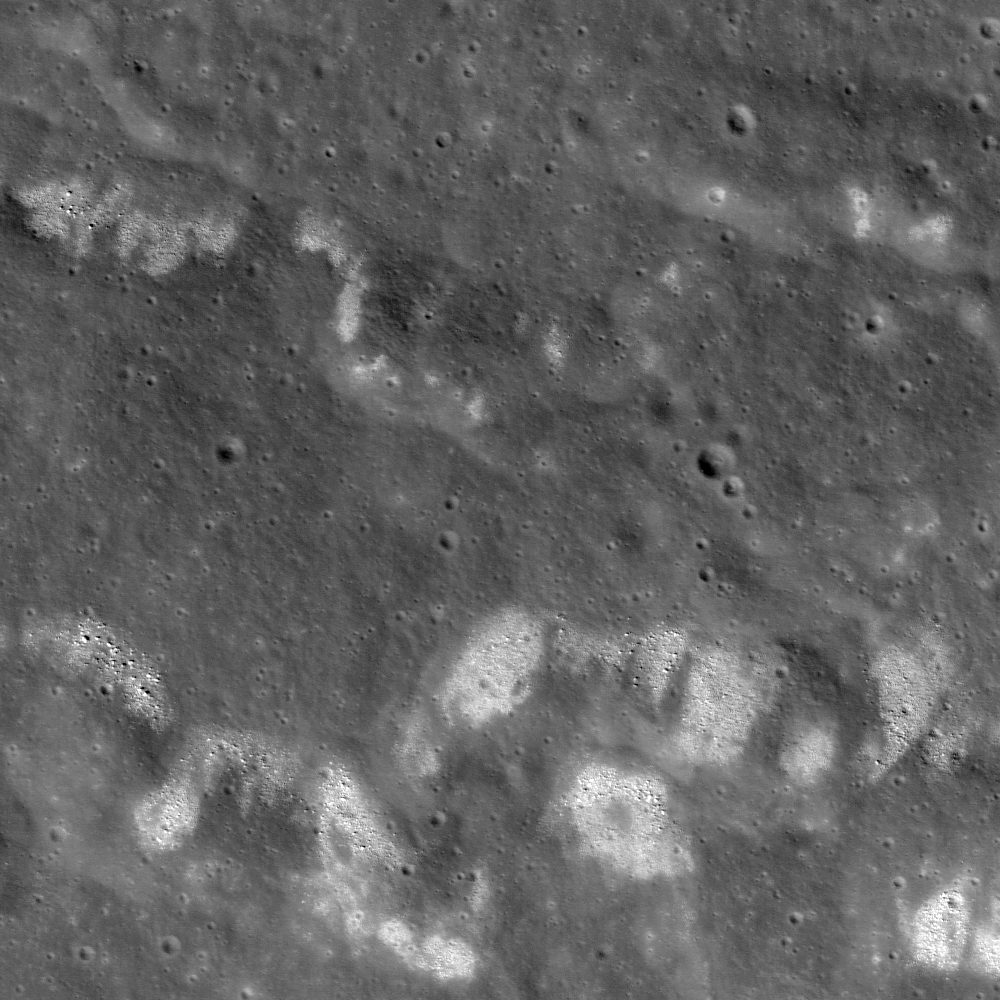
A wrinkle ridge in southwest Mare Serenitatis is littered with boulders and areas of high-albedo, characterized by rough texture. Field of view is approximately 1500 meters across> LROC Narrow Angle Camera frame M106826896L, LRO orbit 884, September 5, 2009; angle of incidence 35.34° at 1.25 meters resolution from 150.42 kilometers [NASA/GSFC/Arizona State University].
Renee French
LROC News System

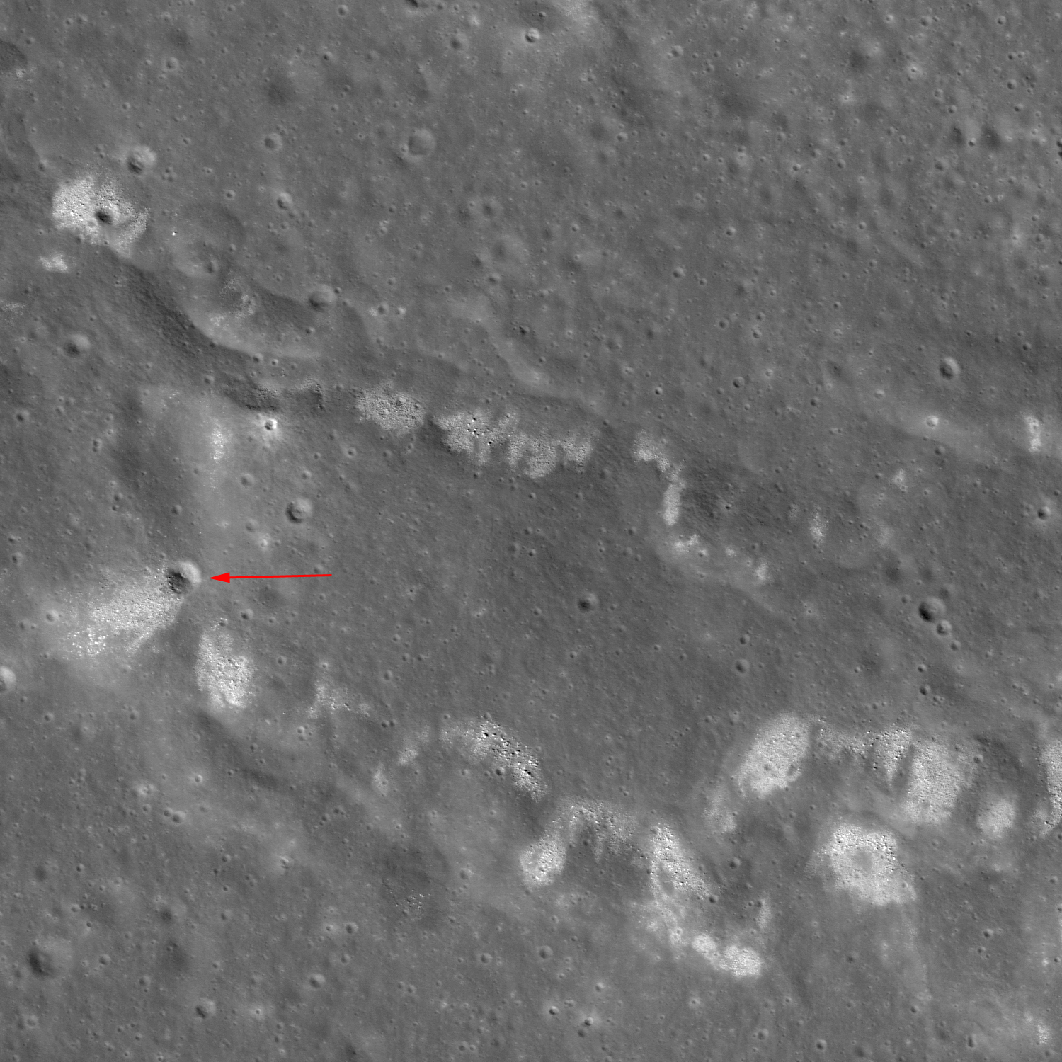
A wrinkle ridge in western Mare Serenitatis (23.448°N, 8.058°E) is one of many in the region that exhibits a high boulder density and high albedo (bright) summit areas. But it isn't the only place this relationship is seen! These bouldered ridges are also observed in Oceanus Procellarum, Mare Humorum, Mare Cognitum, and Mare Nubium, to name a few. Scientists are still uncertain as to why some ridges have these features and others don't, and why this isn't observed along the entire ridge. This ridge seems to be eroding along its slope, rather than the crest, suggesting that the material is coming from the ridge itself. In addition, a small impact crater (red arrow in below image) has excavated boulders and high albedo material, making it more likely that the source is from the ridge and not a product of distant cratering events.

Wider view shows a crater (red arrow) that has excavated the same material eroding out of the ridge.  Field of view approximately 2.3 kilometers across LROC NAC M106826896L [NASA/GSFC/Arizona State University].
There are two ways to describe high albedo on the Moon: either freshly exposed rock and soil, or material with different composition or properties. It is uncertain which description is best for the high albedo observed along these ridges or whether it is a combination of the two. If the boulders and high albedo material have happened because of tectonic activity, then that implies that activity along mare wrinkle ridges has occurred more recently than previously thought. These features need to be studied in more detail in order to fully understand what role they play in lunar history. This is just one of the many surprises that LROC has revealed!

LROC Wide Angle Camera (WAC) 100 meter-per pixel monochrome mosaic in the new and improved LROC WMS image search tool shows the the location of the wrinkle ridge in Mare Serenitatis (yellow arrow) in relation to Apollo 15 landing site near Hadley Rille [NASA/GSFC/Arizona State University].
To view the ridge in more detail, look at the top of the full LROC NAC frame, HERE.

Related Posts:
Zebra Stripes (July 3, 2011)
Bright ridge near Mons Hansteen (April 8, 2011)
Boulder clusters on a ridge crest (March 24, 2011)
Buckland Boulders (March 9, 2011)
Constellation Region of Interest in Mare Tranquillitatis (April 27, 2010)
Wrinkle Ridge Near Montes Teneriffe (December 29, 2009)

UPDATE: A Closer Look. This area of the Serenitatis basin is particularly interesting, under the influence of the extrusive volcanism of Sulpicius Gallus and the unusual elevation slope lower in elevation approaching the southwest basin rim, has been the subject of several earlier posts. As it turns out, for example, we had already, long ago, downloaded the entire 5000 sample by 52224 line NAC image from the Commissioning phase of the LRO mission about three years ago.

In a quick study, again using the continuously improving LROC image search tools, we wanted to see if any higher-resolution LROC NAC observations had been captured since September 5, 2009. Among the overlapping or nearly overlapping LROC NAC Observations we found of this same wrinkle ridge system were at least two perhaps helpful in further illustrating the area of interest.

Barely more than a year after the opening picture was taken, LROC swept over the same region, a bit more to the west of orbit 884, during orbit 5744, and the LROC NAC caught the image above showing the ridge "lobe" visible at lower left in the opening LROC Featured Image. Though Sun was slightly higher in the sky, the spacecraft was 106 kilometers closer, and the image immediately below shows that same ridge "lobe" at 49 cm resolution. LROC NAC M139856476R, angle of incidence 26.26° from 44.33 km [NASA/GSFC/Arizona State University].
The wrinkle ridge "lobe" at full resolution and corrected scale in a 286 meter-wide field of view from LROC NAC M139856476R, orbit 5744, September 23, 2010 [NASA/GSFC/Arizona State University].
While the area in this image does not overlap the left frame of LROC NAC M10682689L, it does overlap the right frame and a part of the same wrinkle ridge system slightly to the east. The field of view is a bit more than 2 kilometers wide, with the area in the white rectangle shown at full resolution immediately below. LROC NAC M126873954R, orbit 3831, April 25, 2010; angle of incidence 34.91° at 48 cm resolution from only 40.48 kilometers [NASA/GSFC/Arizona State University].
Perhaps one of the better close-ups of the boulders gradually being calved from the ridge through mass wasting, another full resolution, this time at a 276 meter-wide field from LROC NAC M126873954R {NASA/GSFC/Arizona State University].

Monday, September 17, 2012

Close-up on the lonely trail of Lunokhod-2

Long and winding road of the last rover deployed on the Moon, Lunokhod-2. Image cropped from a diagonal slice through the rover trail swept up in an extreme close-up of Le Monnier crater August 14, 2012. LROC Narrow Angle Camera (NAC) frame M168000478R, LRO orbit 9892; resolution 41 cm per pixel, angle of incidence 47.65° from 22.11 kilometers [NASA/GSFC/Arizona State University].
The Soviet Union's Lunokhod-2, riding to the lunar surface on the Luna-21 lander, arrived on the Moon January 15, 1973. The 84 kg. rover Lunakhod-2 was afterward deployed and, with the benefit of a robust radioisotope thermoelectric generator to warm itself through the long lunar nights, was teleoperated a total of 37 km, across the southern floor of le Monnier crater, until the following June.

It's not quite as easy to distinguish the twin ruts of the Lunakhod trail in the mosaic of both the right and left-hand frames of LROC NAC observation M168000478. The unusual close-up, from less than half the nominal 50 km altitude, was caught as flight directors prepared to raise LRO's orbit to above 100 km at the end of 2011. Because the camera was considerably closer to the surface, the field of view is quite a bit more narrow, in compliance with the Inverse Square Law, slightly less than one-half kilometer across. LRO was slewed a full 25° off nadir, which resulted in the right-hand frame being very slightly more distorted than the left [NASA/GSFC/Arizona State University].
LROC principal investigator Mark Robinson discussed the Lunokhod-2 mission in detail on March 13, HERE. Also, there are spacecraft panoramas and close-ups of both Luna-21 and Lunokhod-2 at the following links:

Lunokhod-2 revisited (March 13, 2012)
Luna 21 (March 20, 2010)
Lunokhod-1 and Lunokhod-2 (March 17, 2010)

Phil Stooke's familiar survey of the Lunokhod-2 traverse is seen here graced with the scaled mosaic of LROC NAC M168000047, at lower left. The small white box shows the field of view seen at 41 cm resolution in the opening image, above [Google Earth].
ILIADS application perspective of le Monnier, LROC Wide Angle Camera 100 meter global monochrome mosaic draped over LOLA 128 ppd digital elevation model (v.2) [NASA/GSFC/Arizona State University].

Tuesday, July 10, 2012

LROC: "Sunny Side Up"

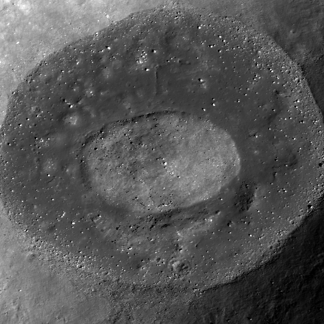
The center of Linne F is filled with a small mound surrounded by a moat of impact melt rock. Image width is ~1450 m, LROC Narrow Angle Camera (NAC) observation M190509409, LRO orbit 13120, May 1, 2012; native resolution 1.5 meters. View the larger (1100 px)) LROC Featured Image release, HERE [NASA/GSFC/Arizona State University]
Drew Enns
LROC News System
 

Linne F is a 5 km diameter crater located at 32.33°N, 13.95°E, and it displays a spectacular melt pond (now frozen) on its floor. Immediately after the impact event, melt pooled and eventually hardened to form the now lower reflectance flat deposit surrounding a central mound. The once molten material shares characteristics that are seen in many other impact craters: small mounds, blocky craters, and fractures. But what is the origin of the central mound? Compare the central mound in Linne F to the interiors of other similarly sized craters. Perhaps it is a proto-central peak or maybe the mound formed due to unusual target properties?

Linne F, surrounded by Mare Serenitatis basalts. LROC QuickMap (64 meters resolution) with profile statistics; field of view is 37.12 km [NASA/GSFC/Arizona State University].
Do any other 5 km diameter lunar craters have central peaks? On the Moon, central peaks start to form in craters between 10-20 km in diameter, much larger than Linne F. If the mound isn't a nascent central peak, perhaps the local target properties of this portion of Mare Serenitatis played a role. Target properties are important for small (<500 m diameter) craters as a loose regolith over solid bedrock can result in benches, mounds, and flat floors. It is unclear if target properties are also important for larger craters, but Mare Serenitatis has a thick layer of basalt overlying older basin material. Both hypotheses are possible, but hard to prove from remotely sensed data alone. Linne F is just one example of the uniqueness of each crater on the Moon. It is easy to generalize that all craters below 10 km in diameter are bowl shaped - but that generalization glosses over the variety of geologic forms seen in lunar craters. It is this richness of detail from crater-to-crater that scientists are studying to unravel the story of the surface, and subsurface, of our nearest neighbor!

Explore more impact melt in the full LROC NAC mosaic, HERE.

Related Posts:
Cracked Mound
Shattering Consequences
Farside impact!

Wednesday, May 16, 2012

LROC: Meandering

Western slope of Fabbroni crater cavity; field of view width 1200 meters (view the original 1200 px LROC Featured Image released May 16, 2012 HERE), downslope is to the east. Unreleased LROC Narrow Angle Camera (NAC) observation M188050156R, orbit 12776, April 2, 2012; 1 meter resolution [NASA/GSFC/Arizona State University].
Hiroyuki Sato
LROC News System

Young fresh lunar craters always present sharp and spectacular features. Today's Featured Image highlights the western slope of the Fabbroni crater located at the north edge of Mare Tranquillitatis, near the Apollo 17 landing site. Slope failures have created many narrow channels of granular material flowing down toward the center of the crater.

The reflectance of a material changes depending on various factors, such as the composition, grain size, and maturity. The crater cavity slope is composed of multiple layers and their debris. The mixtures of these materials exhibit various reflectances, which bring the flow features into sharp contrast.

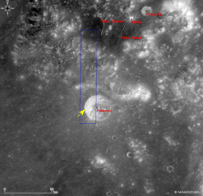
Fabbroni crater and immediate vicinity, near the confluence of Mare Serenitatis and Tranquillitatis. Image cropped from LROC Wide Angle Camera (WAC) monochrome (604nm) mosaic swept up during three sequential orbital passes December 2, 2011; resolution 51 meters from 36.2 kilometers, centered on 18.65°N, 29.27°E, southwest of the landing site of Apollo 17 in 1972. The area highly resolved in the LROC Featured Image released May 16, 2012 is designated by the yellow arrow. The original context image accompanying the Featured Image release, showing a labeled, larger area can be viewed HERE [NASA/GSFC/Arizona State University].

Open up the full NAC frame and explore these spectacular meandering flows by yourself, HERE

Related Posts:
Rock avalanche in Robinson crater
Granular Flow
Dichotomy
Lunar landslides!
Marius A
Pytheas


HDTV still image from above 100 kilometers captured by Japan's lunar orbiter SELENE-1 (Kaguya), released in 2008 shows Fabbroni (left of center bottom) in relation to Mare Serenitatis on the east and Taurus Littrow valley (cul de sac surrounded on three sides by mountains) explored by Cernan and Schmitt of Apollo 17 in December 1972. View the larger image HERE [JAXA/NHK/SELENE].

Tuesday, March 20, 2012

Whale of a hollow

"Another Ina," a 'hollow on the Moon resembling a cave-dweller's representation of a whale, located on the western floor of Mare Tranquillitatis (8.89147°N, 21.48729°E) near the February 1964 impact of Ranger 6. LROC Narrow Angle Camera (NAC) observation M177494593R, orbit 11293, December 2, 2011; incidence angle 62.5° and at a resolution of 0.46 meters per pixel from 38 kilometers [NASA/GSFC/Arizona State University].
Joel Raupe
Lunar Pioneer

Hollows, as distinct from pit craters, have been discovered during the course of the Messenger survey of Mercury. As such, these new discoveries heightened awareness of similar features on the Moon, some of these well-known and others also newly discovered by LRO science teams.

Two hollows, or hollow clusters, for example, have been confirmed in LROC high-resolution images not far from the Moon's most famous example, "Ina," the "D Caldera" well-known to telescope observers looking for the challenging feature from Earth.

All three of these features are presumed to result from outgassing, though details of the dynamic remain elusive. Ina is the most studied, and a small cluster of hollows to its north, situated on an extrusion dome on the edge of the Serenitatis basin is the next most well known. The Ina formation had been thought to be unique, but another smaller version has turned up in three LROC Narrow Angle Camera frames showing the area in Mare Tranquillitatis where Ranger 6 made its impact in 1964.

The whale in the Sea of Tranquility (yellow oval) doesn't stand out like Ina, but even in this simulated oblique view of the LROC WAC 100 meter Global monochrome mosaic, overlaid on am elevation model assembled from LOLA laser altimetry, displayed in the NASA ILIADS application reveals how easy it is to find, if you know where to look [NASA/LMMP/GSFC/Arizona State University].

"Ina," (18.65°N, 5.3°E) an extremely young and unusual 3 by 2 km depression that may represent a gas eruption site on the Moon. LROC Narrow Angle Camera (NAC) observation M119815703, LRO orbit 2791, February 3, 2010 [NASA/GSFC/Arizona State University]
Three examples, each in very different areas of the Moon, seem to represent a range of possibilities. Ina appears very young, and it rests on a wide and flat zone at a relatively high elevation above the Serenitatis basin to its north, in the midst of hills etched deep by the primeval blast that formed Mare Imbrium. There seems to be little sign of an explosive debris field though a rivulet of melt may have run from Ina downslope to the east.

Ina, , north of Mare Vaporum, before local sunset in a roughly 46 kilometer-wide LROC Wide Angle Camera (WAC) color (689 nm) mosaic stitched from sequential observation opportunities; January 6, 2010. The feature is situated in on a high, wide and flat mesa still carrying the scars of the Imbrium impact, eons before Ina took shape. Down slope from the feature, to the east by southeast, younger surface material may be a hint of pyroclastic flow [NASA/GSFC/Arizona State University].
In contrast, a smaller version of Ina, shaped more irregularly and resembling a whale, photographed by the LROC Narrow Angle Camera (NAC) at least three times, is located in western Mare Tranquillitatis. The "Whale," about twelve kilometers south of the Ranger 6 impact (and easier to locate). Though situated on a vast mare plain and at a lower elevation the "Whale" has the tapered edges and "beads" characteristic of Ina.

The "whale" formation under a high local sun, LROC NAC
M139768545R, orbit 5731, September 22, 2010, incidence angle
13.6°, res. 0.5 meters from 44.3 km
[NASA/GSFC/Arizona State
University].
Spectral analysis of Ina, along with crater counts and analysis of space weathering has led to speculation that the feature may be less than 10 million years old, and may enen be reforming periodically. The explosive nature of most lunar morphology does not lend itself well to imagining anything forming on the Moon from something like a slow leak in a tire, but this may be just what has occurred. Despite the apparent youth of its relief Ina (and perhaps the "Whale" in Tranquility, also) don't show much sign of "optical maturity" beyond their borders, a contrasting bright and reflective debris fields we associate with craters. Ina's interior surface does show immaturity, much less of the fusing with nanophase iron from eons of bombardment by highly kinetic atomic nuclei typical of the Moon's exposed surface most everywhere else.

The inevitable reddening, the darkening, of the outer 3 cm. of the lunar surface, from relentless bombardment of solar and extra-solar radiation (particularly cosmic rays) should cause brilliant 109 million year-old Tycho, for example, to fade into the background in just shy of a billion years. But if outgassing formed, or continues to form, Ina or the "whale," both of which show compelling signs of sprightly youth in their exposed interior, where is a fallout field of ejected material beyond?

Though these features may be the result of sporadic or even continuous "slow leaks," this outgassing probably occurred at some pressure. It wouldn't take much for nearly all of this evacuated material to reach escape velocity. And yet, though it's more obvious to the human eye just beyond the lip of the "whale," there actually is a fine "spray" of accumulated, more reflective (less optically mature) material in their immediate vicinity. Just not the macro-jumble of shocked rocks and blocks of every size we are used to seeing around impact craters.

Close up of the lunar hollows that gained the most immediate interest after the discovery of similar features on Mercury, perhaps because they most closely resembled those first located there, though these vents near the apex of a shallow dome on the southwestern edge of Mare Serenitatis (24.48°N, 7.99°E) are considerable smaller.  LROC NAC M104469044R, orbit 555, August 9, 2009; incidence angle 57.65° resolution 1.45 meters per pixel from 145.5 kilometers [NASA/GSFC/Arizona State University].
A third hollow in the lunar catalog is, again, different from Ina or "the whale." The closest view we presently have of the cluster of vent associated with an extrusion dome on the southwestern edge of Mare Serenitatis may not allow us the kind of spectral analysis of their interiors now available for Ina. Disappointingly, the only high-resolution LROC NAC observation in the Planetary Data System (PDS) was captured very early in the LRO's Commissioning Phase, from 145 kilometers overhead.

How old is this extrusion dome, just inside Mare Serenitatis (right)? The southwestern part of the larger basin exhibits a lot of interesting features. The well-known basins of the nearside tend to be lower in elevation than their circumferences. For some reason, however, moving from the interior toward the southwestern edge, elevations slope in the opposite direction. What does this cluster of hollows have in common with the "open" hollows, Ina and "the whale, if anything? [NASA/JAXA/SELENE/LMMP].
It's tempting, anyway, to "see" a fine haze of less optically mature material in wisps outside these hollows, but such a leap would definitely be immature.

The "trough" on the immediate edge of southwestern Mare Serenitatis. The hollows on the apex of an extrusion dome (yellow arrow) are invisible at this scale, though the area boasts a wide anatomical variety of features testifying to the activity that happened here, probably beginning with the Imbrium impact event (over the Apennine front, upper left). A very close examination of this area's surface is needed to see if those hollows, and perhaps other features like Aratus CA, are of a more recent origin. LROC WAC monochrome (604nm) mosaic [NASA/GSFC/Arizona State University].
Related Posts:
Spectral Properties of Ina
(February 7, 2011)
It's a gas, man - (October 8, 2011)
The closest of lunar close-ups, now available (December 16, 2011)
Some LROC Highlights, M. Robinson and the LROC Team (.pdf)
LEAG Conference, December 3, 2009

Thursday, March 15, 2012

LROC: Lunokhod 1 revisited, too

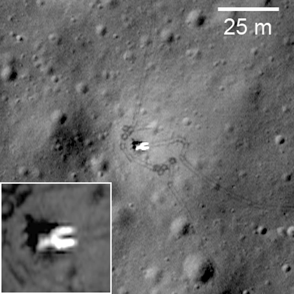
Lunokhod 1 rover in its final parking place (38.315°N, 324.992°E) on the surface of Mare Imbrium. LROC Narrow Angle Camera (NAC) observation M175502049RE, orbit 10998, November 9, 2011, resolution 33 cm per pixel. View original Featured Image with enlarged inset HERE. [NASA/GSFC/Arizona State University].
Jeff Plescia
LROC News System

Luna 17, carrying Lunokhod 1, landed on the flood basalt surface of Mare Imbrium on November 17, 1970, after entering orbit on November 15. 

Today's Featured Image of Luna 17 and Lunokhod 1 was obtained during a low altitude (33 km) pass providing the highest resolution view yet of the landing site.

The same LROC Narrow Angle Camera frame captured both the lander and the Lunokhod 1 lunar rover, and nearly all the wheel tracks the rover left behind, just shy of 42 years afterward.

Luna 17, the lander that carried Lunokhod 1 to the surface; debarking ramps for the rover visible extending down to the surface to the right. Many rover tracks are visible around the lander and throughout LROC NAC frame M175502049RE. View the original contextual image with enlarged inset, HERE [NASA/GSFC/Arizona State University].

Artist’s conception of Luna 17 on the lunar surface, with Lunokhod descending to the surface [Anatoly Zak/Russian Space Web].
Once Luna 17 landed, ramps were deployed on two sides of the lander allowing for two possible directions for the rover to drive to the surface. In this case, the rover drove down the ramps on the east side of the lander. Rover tracks can be seen extending away from and around the rover. Also note the bright area around the Luna 17 lander; the surface was modified by the exhaust gases from the descent engines such that it appears brighter. This increased contract makes the rover tracks more obvious near the lander.

View of the Luna 17 from the Lunokhod 1. The rover descended from the lander on the opposite side. The wide variety of images, including many other firsts, from the Cold War era Soviet lunar program can be viewed HERE.

Lunokhod 1 traveled a total distance of 10.5 km. It was first commanded to drive south from the Luna 17 lander, making a loop across the mare surface, and then returning north to Luna 17. The rover was then directed to proceed farther north, making a small loop to the west, then returning to its track and continuing northward. The payload consisted of a suite of television cameras, a cone penetrometer to determine physical properties of the regolith, and an X-ray spectrometer to determine the chemistry of the regolith. An X-ray telescope and cosmic ray detector were also part of the payload.

Like Lunokhod 2, Lunokhod 1 carried a French-built laser retroreflector. The vehicle was tracked for a short period during the mission then lost. Once the vehicle was located using LRO/LROC images by the LROC team, it was targeted and recovered using the lunar lasers at the Apache Point Observatory. Because of its location away from the Apollo retroreflectors and Lunokhod 2, recovering Lunokhod 1 is important for lunar geophysical studies.

The rover’s journey across the surface formally ended on October 4, 1971, after 11 lunar day-night cycles (322 Earth-days). Attempts to contact the rover after the lunar night that began on September 14, 1971 were unsuccessful, apparently due to a failure of some component of the rover during the lunar night.

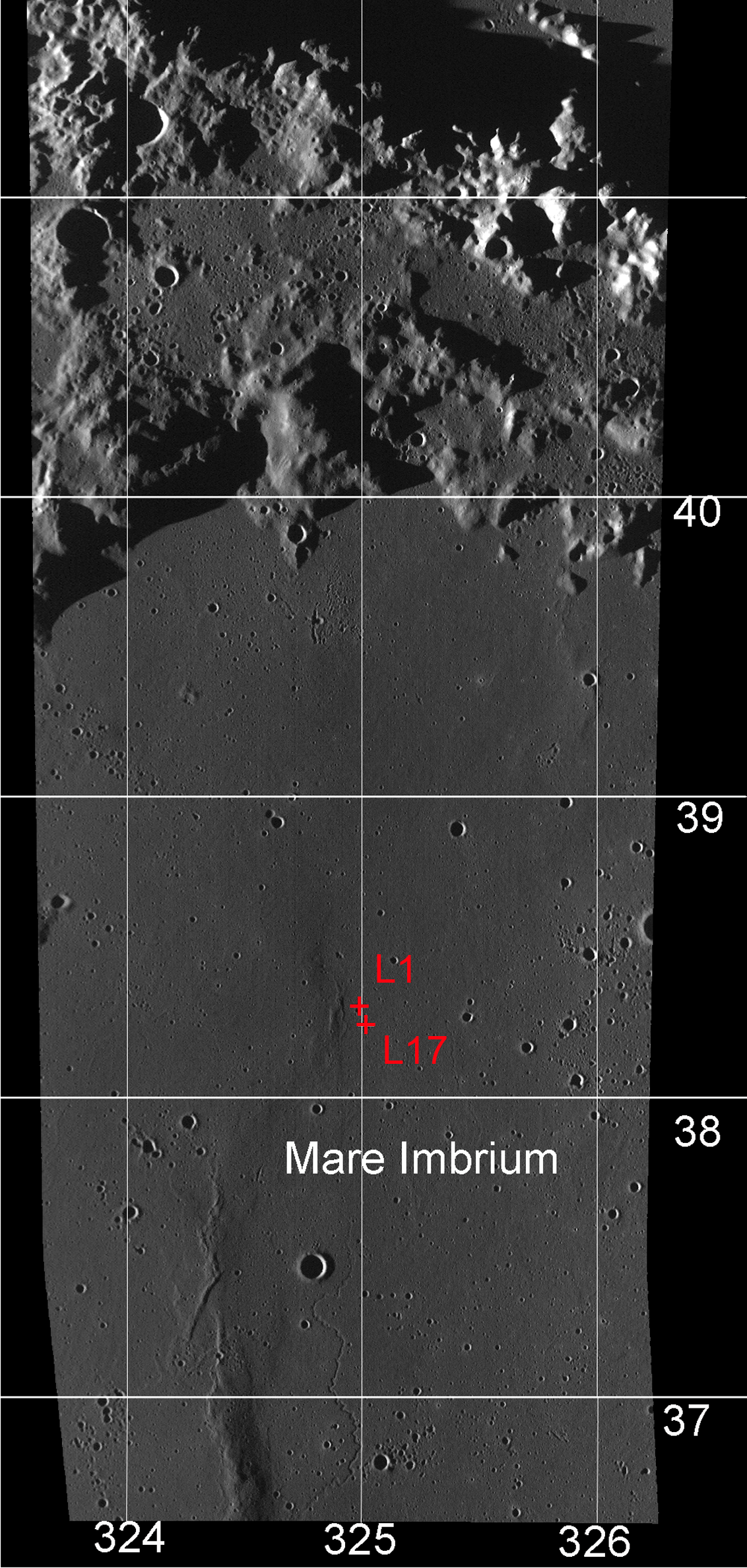
Northern Mare Imbrium showing the location of the Luna 17 landing site and the final position of the Lunokhod 1 rover. View the larger LROC WAC context image HERE. [NASA/GSFC/ Arizona State University].

Explore the Lunokhod 1 site on your own HERE.

Revisit about the earlier LROC "rediscovery" of Lunokhod 1 HERE.

Tuesday, March 13, 2012

LROC: Lunokhod 2 revisited

The tele-operated Soviet Lunokhod 2 rover, the last lunar rover deployed on the Moon, parked facing southeast with the lid still open 39 years later. Rover tracks extend north to this final parking place. The inset is a zoomed in view, the main body is labeled B and open lid labeled L, with the instrument suite (including its French-built laser-ranging retro-reflector array, still in use) on the front labeled I. LROC Narrow Angle Camera (NAC) observation M175070494, orbit 10934, November 4, 201; resolution 30 cm per pixel [NASA/GSFC/Arizona State University].
Mark Robinson
Principal Investigator
Arizona State University

The Lunokhod 2 rover is still parked on the floor of the crater Le Monnier (25.830°N, 30.914°E). This NAC image was taken when the spacecraft was only 24 km above the surface, zipping along at about 1.6 km/sec (about 3600 mph). The spacecraft had to turn on its axis 27° to view the rover. The resolution is about two times higher than usual!

The Lunokhod 2 rover was carried to the surface on board the Luna 21 spacecraft. Lunokhod is the English translation of the Russian word “Луноход”, meaning Moon Walker. The ensemble was launched on 11 January 1973 and the landing occurred on 15 January in Le Monnier crater on the eastern margin of Mare Serenitatis. The coordinates of the landing site are 26.005°N, 30.406°E (on the basis of nine observations) at an elevation of -2769 m (1734630.9 m radius).

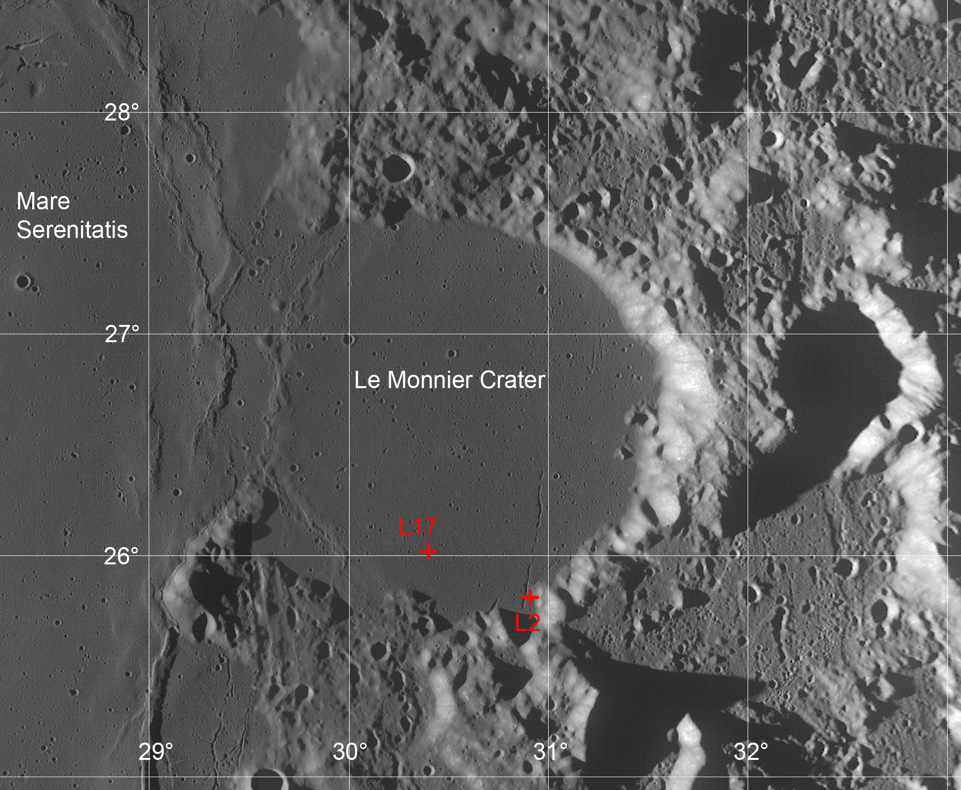
Le Monnier crater lies on the eastern wall of the Serenitatis basin. Lavas that compose Mare Serenitatis also flooded the floor of this 61 kilometer diameter ancient crater. The two red crosses indicate the locations of the Luna 21 lander (L21) and the ultimate  parking spot of the Lunokhod 2 rover (L2) after enduring three full lunar nights. View the original full resolution context image HERE [NASA/GSFC/Arizona State University/USGS/JAXA/Phil Stooke/Google].
Lunokhod 2 is about 170 cm (5’ 7”) long x 160 cm (5’ 3”) wide x 135 cm (4’ 5”) tall, and it is almost circular when viewed from above. The vehicle had eight wheels and could travel at either 1 km/hr or 2 km/hr (0.6 and 1.2 mph). The lid on the top of the rover served to provide solar power and to keep the vehicle warm at night. When the lid was opened, the solar cells collected energy to operate the rover. At night, the lid was closed and a fluid heated by the decay of Polonium-210 kept the rover warm. The rover was controlled remotely by a team of Soviet controllers on Earth.

Lunokhod rover in publicity still. Note the mesh wheel design and LRRR on the extended instrument suite housing [Russian Space Academy].
During its 37 km traverse, Lunokhod 2 headed south from the landing site and into the highlands from the southern rim of Le Monnier crater. Lunokhod 2 had difficulty on the slopes of the southern rim so it was turned northward and commanded to backtrack to the flat mare basalts that form the floor of Le Monnier. It then continued eastward across the crater floor eventually encountering a 250 wide north-northeast trending rille named Fossa Recta (Straight Rille).

The Luna 21 lander with ramps deployed on both sides,
to the northwest and to the southeast. LROC NAC
M122007650L [NASA/GSFC/Arizona State University].
Lunokhod 2 drove off the lander to the northwest and circled around to the east. Several turns were made as the rover photographed the lander. It then departed and headed south.

The rover had to work its way down the rille wall and across the floor before finally climbing out on the east side. Lunokhod 2 continued north before reaching its final position. The mission officially ended on 4 June 1973 due to a failure of the rover. Apparently on 9 May, the rover’s lid touched a crater wall and become covered with fine-grained lunar regolith. That regolith was dumped onto the radiators when the lid closed. Subsequently, when the lid opened, the rover overheated and failed.

The scientific payload on the rover included three television cameras for navigation, four panoramic cameras, a cone penetrometer to test the lunar regolith, a solar X-ray experiment, a magnetometer, radiometer, and laser ranging retroreflector.
Luna 21 lander as seen from the Lunokhod 2 rover. This view as taken from south of the lander looking to the northwest. The tracks around the east side of the lander are quite apparent, note the small berms of regolith that were pushed up as the rover turned. Lunation 1, Session 4, Panorama 12 [RSA]..
Examine the regional geology that Lunokhod 2 was exploring, HERE (hint: sample 4493, line 15645; look to the south for some spectacular rover tracks).

First LROC Featured Image of the Lunokhod rovers.

Friday, January 6, 2012

'Significant change' in bombardment timing

Among the things complicating the definitive dating of the familiar nearside basins is each shows signs of having been resurfaced more than once after their violent formation. Researchers progressed rapidly with secondary and primary crater counting and by retracing contours of topography based on the principle of superposition, that newer craters disrupt the old. Direct sampling allowed further for radio-isotope dating. Now high-resolution photography from LRO is allowing the reading of topography under nearly all lighting conditions. Painstaking analysis in years past has recently been renewed, suggesting a need for revision to the age of Serenitatis basin.
"A Significant change in our view of the impact process, and the history of the Earth-Moon system" is offered by three leading planetary scientists following a pain-staking analysis of LROC images of the eastern side of Mare Serenitatis.

Research by three eminent planetary scientists in the American Geophysical Union's Journal of Geophysical Universe will almost certainly cause a revision in generally accepted lunar timescale and ages for the Moon's most familiar basins. This is so primarily because the authors have had much to do with gathering the original evidence for the accepted dating over the past four decades. Based on high-resolution photography returned by the Lunar Reconnaissance Orbiter Camera their most recent work is filling gaps in tried and true methods for reading the story of the Moon (and the Solar System) engraved on the lunar surface.

The wide-ranging effect of the impact that formed Mare Imbrium has been obvious since the invention of the telescope. Just how widespread has been more difficult to determine. This LROC Wide Angle Camera (WAC) mosaic shows the mixed terrain of the Sulpicius Gallus area within and adjacent to the southwest corner of Mare Serenitatis basin. Radial grooving from Mare Imbrium (not shown), testifies clearly as to the violence unleashed by that basin-forming impact. Until very recently it was thought Serenitatis basin must have formed after the Imbrium event.  [NASA/GSFC.Arizona State University].
LROC WAC monochrome (643nm) observation M119645947ME, LRO orbit 2766, February 1, 2010. Astronauts Gene Cernan and Jack Schmitt explored the Taurus Littrow valley, in the hills southeast of Serenitatis in 1972. The forces that shaped South Massif (SM), North Massif (NM) and the Sculptured Hills (SH) were thought to have originated with the Serenitatis impact event. More recent study of LROC imagery, however, appears to show their near final form resulted from the Imbrium basin-forming impact [NASA/GSFC/Arizona State University].
The Taurus Littrow Valley, explored by Cernan and Schmitt of Apollo 17 (White Arrow, 1972) is a crossroads of lunar morphology immediately adjacent to the Serenitatis basin. Geologist astronaut Harrison "Jack" Schmitt, for example, confirmed his theory that the "Tortilla Flat" ray of material he and Capt. Cernan explored during their second EVA was radial to the 109 million year old "recent" Tycho crater.

At Shorty crater an abundance of orange regolith had been naturally excavated, offering evidence of ancient fire fountains deep in in the Moon's primeval past. Still, snuggled near the shore of Mare Serenitatis, it was far from certain if the Sculptured Hills and other mountains around the valley, indeed whether the valley itself, had been sculpted out originally by the force of the Serenitatis or the more distant Imbrium basin-forming impact.

During their third and final EVA, the last walk the Moon on December 13, 1972, Cernan and Schmitt had the opportunity to sample "Tracy's Rock," or 'Split Rock', a hefty boulder that had, at some point in the relatively recent past, rolled down the south-facing wall of North Massif where it partly broke apart near the valley floor. It offered an opportunity to analyze and sample part of the high mountains imaged almost four decades later from LRO.

Tracy's Rock - the split boulder that brought a significant sample of the Sculptured Hills-type mountains, in this case the North Massif down to the Taurus Littrow valley floor, where geologist astronaut Jack Schmitt and Apollo 17 commander Capt. Gene Cernan could sample it during the last walk on the Moon, December 13, 1972. At top, the same boulder heap is seen in LROC NAC observation M165645700RE, orbit 9545, July 18, 2011; resolution 47.7 cm per pixel from 40.6 kilometers [NASA/GSFC/Arizona State University].
Distinguished planetary geologist Don E. Wilhelms, retired from the U.S. Geological Service, Paul D. Spudis of the Lunar and Planetary Institute and LROC principal investigator Mark Robinson of Arizona State co-wrote the study published in late December. They conclude LRO imagery show the Serenitatis basin is relatively old, not young. 

Additionally, "an old Serenitatis means Apollo 17 impact melts may not date the Serenitatis basin," and either the late bombardment theory was less likely or the Moon's morphology is more poorly understood than is generally believed.

"New images from the Lunar Reconnaissance Orbiter Camera show the distribution and geological relations of the Sculptured Hills, a geological unit widespread in the highlands between the Serenitatis and Crisium basins. The Sculptured Hills shows knobby, undulating, radially textured and plains-like morphologies, and in many places is indistinguishable from the similarly knobby Valles Alpes formation, a facies of ejecta from the Imbrium basin.

"The new LROC image data show the Sculptured Hills in the Taurus highlands is Imbrium ejecta, not directly related to the formation of the Serenitatis basin. This occurrence and the geological relations of this unit suggest the Apollo 17 impact melt samples may not be not samples of the Serenitatis basin-forming impact, leaving their provenance undetermined and origin unexplained. If the Apollo 17 melt rocks are Serenitatis impact melt, then up to half the basin and a large crater population on the Moon was created within 30 million year interval around 3.8 billion years ago, in a global impact “cataclysm.”

"Either interpretation significantly changes our view of the impact process and history of the Earth-Moon system."

Abstract and Text (Subscription), HERE.
The Sculptured Hills of the Taurus Highlands:
Implications for the relative age of Serenitatis,
basin chronologies and the cratering history of the Moon
.
JOURNAL OF GEOPHYSICAL RESEARCH
VOL. 116, E00H03, 9 PP., 2011
doi:10.1029/2011JE003903