Showing posts with label Don Wilhelms. Show all posts

Saturday, November 3, 2012

Ocean of Storms, Oceans of Argument

Oceanus Procellarum, the "Ocean of Storms," is easily the largest feature of the Moon's complex topography visible, even to the naked eye, from Earth. But is it a true remnant of a basin-forming impact, merely a low remnant of early lunar morphology or perhaps the largest remnant of a hemisphere-sized impact some have labeled "Gargantua? Thumbnail of a 48-image mosaic captured by Yuri Goryachko, Mikhail Abgarian and Konstantin Morozov (ASTRONOMINSK) of Belarus, August 3, 2010.
Paul D. Spudis
The Once & Future Moon
Smithsonian Air & Space

Once upon a time, back in the Dark ages when I was a young student of lunar science, an idea was advanced that Oceanus Procellarum (the largest dark maria on the near side of the Moon) was the site of an ancient, almost obliterated impact basin.  This “Procellarum basin” (then called the “Gargantuan” basin – superlatives fail us sometimes) has been invoked to explain any and every observed aspect of lunar geology, from the distribution of the dark mare lavas, the near/far side dichotomy, the thickness of the crust, the composition of highland rocks, and the relative amounts of radioactively generated heat flow in the Moon.  Such a useful concept to explain so much!

The acceptance by lunar scientists of a Procellarum basin has waxed and waned over the years.  Originally proposed by Peter Cadogan in 1974, the presence of a large, ancient impact basin covering most of the western near side of this part of the Moon, was advanced to explain the unusually high concentration of the chemical component called KREEP – (K) potassium, (REE) rare earth elements, and (P) phosphorus.  Subsequently, Ewen Whitaker (noted cartographer of the Moon) carefully mapped landforms, such as ridges and massifs (mountains) over this area, which purportedly showed that the patterns were best explained by a three-ring basin – 3200 km across, centered on the western near side.  Whitaker named this feature the “Procellarum basin” after the largest mare region that filled it.  Lunar geologist Don Wilhelms fully embraced this interpretation in his classic book The Geologic History of the Moon, making the Procellarum basin the prime cause for the distribution of geologic units on the Moon.
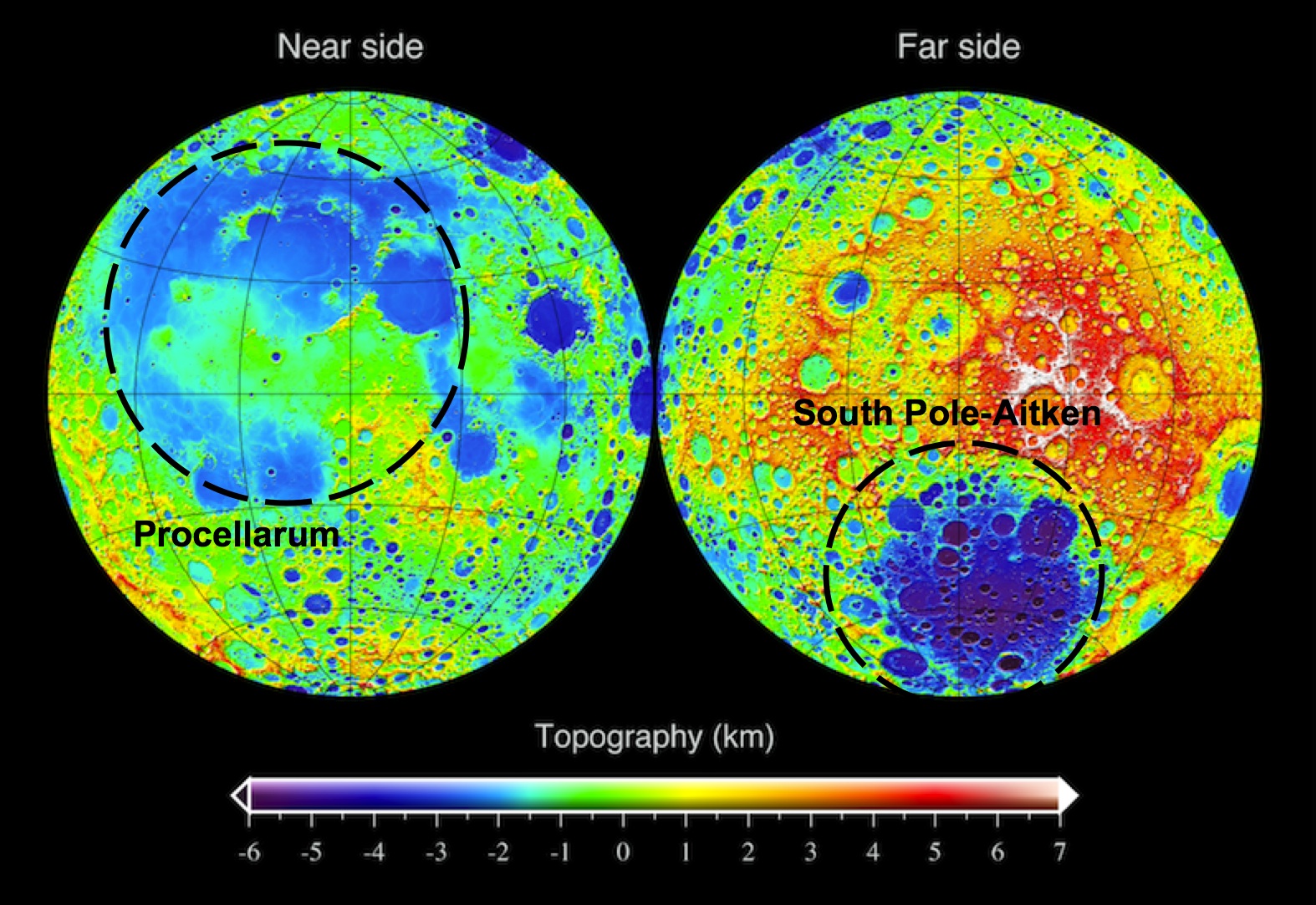
LRO topographic map of the Moon, showing the approximate outline of the "Procellarum" basin on the near side (left) and the South Pole-Aitken basin on the far side (right). One's real, the other isn't.
Yet doubts persisted.  In 1985, Peter Schultz and I suggested that the quasi-concentric arrangements mapped by Whitaker, were related to the Imbrium basin (not to an earlier, underlying mega-basin) on the basis of the ring pattern of this putative feature.  We also pointed out that the patterns of rock compositions supposedly explained by a Procellarum basin were not consistent everywhere, at least casting doubt on the predictive power of the basin’s presence.  The 1994 Clementine mission gave us our first global topographic map of the Moon.  Interestingly, that map dramatically revealed the presence of a circular mega-basin on the far side of the Moon – the enormous 2600 km-diameter South Pole-Aitken basin.  The Procellarum region was also shown to be a low region, but it is not circular (more horseshoe-shaped) and is not as clearly defined as Whitaker’s ring structure suggested.  The stock in the existence of Procellarum basin declined.

But some ideas in lunar science never really go away.  Since that time, several attempts have been made to resurrect the basin.  The latest effort, just published in Nature Geoscience, comes from mineralogical mapping data obtained from the Japanese Kaguya (SELENE) mission.  The authors of this study claim that orthopyroxene (a magnesium-silicate mineral) is distributed on the Moon in association with its largest basins – South Pole-Aitken and Imbrium.  However, in addition to those occurrences, additional outcrops occur in the highlands adjacent to Oceanus Procellarum.  Therefore, these rocks were made during the slow cooling of an enormous impact melt sheet created by the impact which formed the Procellarum basin.

The logic here seems weak.  It has not been established that orthopyroxene only forms from the slow cooling of an impact melt sheet.  When this mineral occurs with the most abundant mineral of the lunar highlands (plagioclase), it makes up a rock type called norite.  Norite is very abundant on the Moon.  It is the dominant rock type at the Apollo 14, 15 and 17 landing sites and occurs elsewhere on the Moon in quantity.  It is particularly prevalent around the edges of the Imbrium basin and one could argue that norite is a characteristic of that basin and the presence of Procellarum basin to explain its occurrence is unnecessary.  Likewise, the existence here of a large differentiated impact melt sheet is inferred from analogy to a terrestrial example, the Sudbury igneous complex, but even in this case, the impact origin of the terrestrial igneous body is not universally accepted.

Evidence for the existence of Procellarum basin must be sought in its topography.  The clarity and preservation of the far side’s South Pole-Aitken basin in the topographic data is surprising.  This feature is one of the oldest on the Moon, yet it preserves relief of over 12 km (the depth one would expect of a fresh feature).  One might expect such an old feature to be indistinct at best, making the discovery of its large relief one of the surprises of the Clementine mission.  At the same time, Procellarum is a vast irregular depression averaging less than 3-4 km deep; its lack of topographic expression is more in line with what one might expect for the oldest basin on the Moon.  However, unlike all other lunar basins, a topographic bulge 2-3 km high occurs near the center of this feature (near the crater Copernicus).  No other basin on the Moon (or on any other planet) contains interior topography higher than the elevation of its topographic rim; at SPA, all of the terrain within the 2600 km diameter rim crest is lower than its rim.  The unusual relation of a bulge within Procellarum does not support the concept that it is an impact basin.  It seems more likely that it is either a feature of internal origin (possibly related to early melting episodes) or a coalescence of several overlapping impact craters and basins.

The elliptical South Pole-Aitken (SPA) basin, mostly on the Moon's farside though it's mountainous outer ring encompasses the the nearside's polar south and the Moon's lowest elevations. The oldest and largest of the Moon's definitively identified impact basins, recent studies appear to have pushed it's formation back beyond 4.1 billion years ago, within less than 500 million years after the formation of Earth and Moon [NASA/GSFC/LOLA].
As we search for the truth, Procellarum basin may well crop up again.  But for today and contrary to the current space press, the new results do not uniquely point to the existence of a large basin here.  In fact, the observations tend to support previous ideas that it is the smaller, overlying Imbrium basin that is associated with a large regional ejecta blanket of roughly noritic composition.

Originally published at his Smithsonian Air & Space blog The Once and Future Moon, Dr. Spudis is a senior staff scientist at the Lunar and Planetary Institute. The opinions expressed are those of the author and are better informed than average.

Friday, January 6, 2012

'Significant change' in bombardment timing

Among the things complicating the definitive dating of the familiar nearside basins is each shows signs of having been resurfaced more than once after their violent formation. Researchers progressed rapidly with secondary and primary crater counting and by retracing contours of topography based on the principle of superposition, that newer craters disrupt the old. Direct sampling allowed further for radio-isotope dating. Now high-resolution photography from LRO is allowing the reading of topography under nearly all lighting conditions. Painstaking analysis in years past has recently been renewed, suggesting a need for revision to the age of Serenitatis basin.
"A Significant change in our view of the impact process, and the history of the Earth-Moon system" is offered by three leading planetary scientists following a pain-staking analysis of LROC images of the eastern side of Mare Serenitatis.

Research by three eminent planetary scientists in the American Geophysical Union's Journal of Geophysical Universe will almost certainly cause a revision in generally accepted lunar timescale and ages for the Moon's most familiar basins. This is so primarily because the authors have had much to do with gathering the original evidence for the accepted dating over the past four decades. Based on high-resolution photography returned by the Lunar Reconnaissance Orbiter Camera their most recent work is filling gaps in tried and true methods for reading the story of the Moon (and the Solar System) engraved on the lunar surface.

The wide-ranging effect of the impact that formed Mare Imbrium has been obvious since the invention of the telescope. Just how widespread has been more difficult to determine. This LROC Wide Angle Camera (WAC) mosaic shows the mixed terrain of the Sulpicius Gallus area within and adjacent to the southwest corner of Mare Serenitatis basin. Radial grooving from Mare Imbrium (not shown), testifies clearly as to the violence unleashed by that basin-forming impact. Until very recently it was thought Serenitatis basin must have formed after the Imbrium event.  [NASA/GSFC.Arizona State University].
LROC WAC monochrome (643nm) observation M119645947ME, LRO orbit 2766, February 1, 2010. Astronauts Gene Cernan and Jack Schmitt explored the Taurus Littrow valley, in the hills southeast of Serenitatis in 1972. The forces that shaped South Massif (SM), North Massif (NM) and the Sculptured Hills (SH) were thought to have originated with the Serenitatis impact event. More recent study of LROC imagery, however, appears to show their near final form resulted from the Imbrium basin-forming impact [NASA/GSFC/Arizona State University].
The Taurus Littrow Valley, explored by Cernan and Schmitt of Apollo 17 (White Arrow, 1972) is a crossroads of lunar morphology immediately adjacent to the Serenitatis basin. Geologist astronaut Harrison "Jack" Schmitt, for example, confirmed his theory that the "Tortilla Flat" ray of material he and Capt. Cernan explored during their second EVA was radial to the 109 million year old "recent" Tycho crater.

At Shorty crater an abundance of orange regolith had been naturally excavated, offering evidence of ancient fire fountains deep in in the Moon's primeval past. Still, snuggled near the shore of Mare Serenitatis, it was far from certain if the Sculptured Hills and other mountains around the valley, indeed whether the valley itself, had been sculpted out originally by the force of the Serenitatis or the more distant Imbrium basin-forming impact.

During their third and final EVA, the last walk the Moon on December 13, 1972, Cernan and Schmitt had the opportunity to sample "Tracy's Rock," or 'Split Rock', a hefty boulder that had, at some point in the relatively recent past, rolled down the south-facing wall of North Massif where it partly broke apart near the valley floor. It offered an opportunity to analyze and sample part of the high mountains imaged almost four decades later from LRO.

Tracy's Rock - the split boulder that brought a significant sample of the Sculptured Hills-type mountains, in this case the North Massif down to the Taurus Littrow valley floor, where geologist astronaut Jack Schmitt and Apollo 17 commander Capt. Gene Cernan could sample it during the last walk on the Moon, December 13, 1972. At top, the same boulder heap is seen in LROC NAC observation M165645700RE, orbit 9545, July 18, 2011; resolution 47.7 cm per pixel from 40.6 kilometers [NASA/GSFC/Arizona State University].
Distinguished planetary geologist Don E. Wilhelms, retired from the U.S. Geological Service, Paul D. Spudis of the Lunar and Planetary Institute and LROC principal investigator Mark Robinson of Arizona State co-wrote the study published in late December. They conclude LRO imagery show the Serenitatis basin is relatively old, not young. 

Additionally, "an old Serenitatis means Apollo 17 impact melts may not date the Serenitatis basin," and either the late bombardment theory was less likely or the Moon's morphology is more poorly understood than is generally believed.

"New images from the Lunar Reconnaissance Orbiter Camera show the distribution and geological relations of the Sculptured Hills, a geological unit widespread in the highlands between the Serenitatis and Crisium basins. The Sculptured Hills shows knobby, undulating, radially textured and plains-like morphologies, and in many places is indistinguishable from the similarly knobby Valles Alpes formation, a facies of ejecta from the Imbrium basin.

"The new LROC image data show the Sculptured Hills in the Taurus highlands is Imbrium ejecta, not directly related to the formation of the Serenitatis basin. This occurrence and the geological relations of this unit suggest the Apollo 17 impact melt samples may not be not samples of the Serenitatis basin-forming impact, leaving their provenance undetermined and origin unexplained. If the Apollo 17 melt rocks are Serenitatis impact melt, then up to half the basin and a large crater population on the Moon was created within 30 million year interval around 3.8 billion years ago, in a global impact “cataclysm.”

"Either interpretation significantly changes our view of the impact process and history of the Earth-Moon system."

Abstract and Text (Subscription), HERE.
The Sculptured Hills of the Taurus Highlands:
Implications for the relative age of Serenitatis,
basin chronologies and the cratering history of the Moon
.
JOURNAL OF GEOPHYSICAL RESEARCH
VOL. 116, E00H03, 9 PP., 2011
doi:10.1029/2011JE003903

Wednesday, September 29, 2010

Copernicus and the lunar timescale

Updated Wednesday September 29, 2010 1039 UT

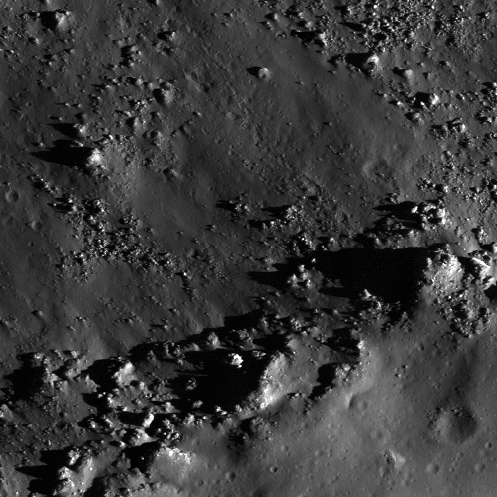
LROC Narrow Angle Camera view of the southern rim of Copernicus, down-slope to upper left. (Original-size view, HERE.) The fragmented material demarcates the rough edge of the crater rim. The surface texture is still sharp and crisp, indicating a relatively young age (note the boulder tracks) 470 meter width from LROC NAC observation M129418341L, LRO orbit 4206, May 25, 2010; alt. 39.41 km, res. 47.2 cm/pixel, phase angle = 57.53 [NASA/GSFC/Arizona State University].

Mark Robinson
Principal Investigator
Lunar Reconnaissance Orbiter Camera
Arizona State University


Copernicus crater played a key role as pioneering lunar geologists Gene Shoemaker and Robert Hackman unraveled the basic stratigraphy of the Moon fifty years ago. Stratigraphy is the science of determining relative ages of geologic materials by observing overlapping relationships between different geologic units. What is a unit? In the case of the Moon, the most basic geologic units include crater ejecta, mare basalt, volcanic ash, and the ancient highlands crust. Dr. Shoemaker and his colleagues noted that rays from different craters exhibited a range of albedos, from the very bright (Aristarchus crater) to the barely visible (Copernicus crater).


Copernicus (9.7°N, 340.0°E) in late afternoon. (Larger view) LROC Wide Angle Camera mosaic (LROC WAC Previewer (v.1.16), Microsoft ICE) from six LRO orbital passes (orbits 2466-2471) January 8, 2010 [NASA/GSFC/Arizona State University].

They correctly inferred rays fade with time, as they are sand blasted by micrometeorite impacts and exposed to the relentless effects of solar wind, cosmic rays: processes often referred to as “space weathering.” By tracing the path of rays, relative ages of many units can be easily determined.


LROC Wide Angle Camera mosaic showing Copernicus crater (L), Eratosthenes (R) along the southern rim of the vast Mare Imbrium impact basin. Ejecta of Copernicus cross over Eratosthenes, showing Copernicus is younger. Image field of view is ~400 km, north is up [NASA/GSFC/Arizona State University].

Just to the east of Copernicus crater is another key crater that in the lunar stratigraphic story revealed by Shoemaker and colleagues, Eratosthenes (58 km diameter). The two neighboring craters look very similar in terms of the freshness of morphological features (rim, walls, central peak), however Eratosthenes has no rays – they have completely faded into the background. The fact that Eratosthenes has no rays shows it is older than Copernicus, but the fact that its form is still sharp indicates that it is not so old that smaller impacts have worn it down. So Eratosthenes is "middle aged" in the lunar timescale. When the lunar timescale was unraveled, scientists had no samples from the Moon so they could not accurately determine the absolute ages of the geologic units they identified.


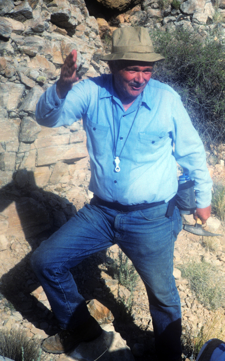
Gene Shoemaker (1928-1997) made many major contributions to planetary science. One of his most significant was deducing and proving that Meteor Crater in Arizona was formed as the result of an asteroid slamming into the Earth. Here he is seen enthusiastically telling the story of Meteor Crater to a new generation of planetary scientists while perched on the steep interior walls of the crater [Photo by Mark Robinson].

Later, material believed to be Copernicus ejecta was sampled by Apollo 12 astronauts, and these samples were radiometrically dated to be close to 800 million years old. 800 million years old is certainly an ancient age by terrestrial standards but is a relatively young age for the Moon. We have no samples from Eratosthenes and thus its absolute age is inferred from counts of smaller craters that have formed on its ejecta and interior. To this day, our knowledge of the ages of the Copernican and Eratosthenian units are poorly constrained. Obtaining samples of key areas within these two periods is a high priority amongst lunar scientists.


Farther down the terraced walls toward the crater floor, boulders of variable sizes are eroding out of the steep slopes. Many boulders are precipitously sticking out of the crater walls, such as the ~50 m boulder in the lower right. Erosion has completely freed some boulders, as evidenced by the boulder trail in the upper right. Downslope direction is toward the upper left, image field is 470 m [NASA/GSFC/Arizona State University].

As scientists learned more about the Moon from Lunar Orbiter and Apollo missions, the lunar timescale was refined. However, the Shoemaker and Hackman work still stands as our basic understanding of lunar stratigraphy. To learn more on lunar stratigraphy and other aspects of lunar geology, you can consult Don Wilhelm’s tome “The Geologic History of the Moon”. It is a serious read, but summarizes much of what we know about the Moon from a historical geology point of view. Certainly, the exciting results from LRO and three recent international missions (SELENE/Kaguya, Chang’E-1, and Chandrayaan-1) will provide many opportunities to revise past ideas! Perhaps Dr. Wilhelms will revise his masterpiece in the near future?

Explore the well-preserved impact landforms of Copernicus crater in the full NAC image and the WAC mosaic.


As an appropriate segue, a look at Shoemaker crater, once part of the stubbornly elusive, nearly completely shadowed terra incognitia near the Moon's South Pole. The South Pole LROC WAC mosaic below shows Shoemaker in visible light, while this 2009 image show the area, really for the first time, in star light, data collected by the Diviner instrument, also on-board LRO. Shoemaker became an even more fitting tribute to Dr. Shoemaker as final resting place for at least a portion of his remains which were deorbited here with Lunar Prospector, July 31, 1999. [NASA/GSFC/UCLA].

Thursday, August 5, 2010

Concentric Gruithuisen K


Inner rim of Gruithuisen K (35.4° N, 317.3° E) from a subset of LROC NAC observation M111877130L. Image width = 510 meters, north is up and sunlight is from the lower right (Full image, HERE.) [NASA/GSFC/Arizona State University].

Sarah Braden
LROC News System

Impact craters affect the entire surface of the Moon, from micron-sized pits to multi-ringed impact basins. Lunar craters also have a wide array of morphologies. Generally, the size and the morphology of a crater depends on the size and velocity of the impacting bolide. Lunar scientists have used crater size and form to group lunar craters into three basic categories: simple craters, complex craters, and multi-ringed basins.


Kaguya wide view shows the proximity of Gruithuisen K to the interesting "Braided Rill" formation approximately 50 km southwest in Oceanus Procellarum. Field of view is around 70 km. Charles Wood, curator of the Lunar Picture of the Day (LPOD), featured a superior level of detail and recommended discussion about this still-perplexing formation, December 22, 2009. Kaguya (SELENE-1) Terrain Camera (TC-056-1) [JAXA/SELENE].

Simple craters are circular, bowl-shaped, and usually less than 10-15 km in diameter. Complex craters are usually larger than 10-20 km in diameter and have a well-defined central peak. Complex craters also often have a rim with one or more terraces. The central peak is brought up from great depths beneath the crater as the ground elastically rebounds after the shock and pressure of the bolide impact. Multi-ringed basins are remnants of the largest impacts on the lunar surface and usually have more than one rim (such as the 1100 km diameter Imbrium Basin).

See Chapter 3 of Geologic History of the Moon by Don Wilhelms for more information about lunar impact craters.


LROC Wide Angle Camera context view for today's Featured Image centered on Gruithuisen K, adjacent to a mare-highlands boundary. (Subset of WAC frame M117773324 [NASA/GSFC/Arizona State University].

Some craters possess characteristics outside of these basic categories. Elliptical, polygonal, and concentric craters are further classifications for craters on the Moon. Elliptical, or oval-shaped, craters form when the impactor hits the surface at an oblique angle, usually around 10° or less. Polygonal craters can form for a number of reasons, and usually the morphology results from pre-existing structural weaknesses in the material at the impact site, such as what is observed with the terrestrial Meteor Crater.

Today's Featured Image is of Gruithuisen K, an example of a class of impact structure referred to as a concentric crater. Gruithuisen K has an inner and outer rim, as well as hummocky material between the inner and outer walls. One possible explanation for concentric craters like Gruithuisen K is that geologic layers with different strength properties in the target zone produce the “rings” of concentric craters. Since the weathering processes (like wind and rain) that eventually obscure impact structures here on Earth don't occur on the Moon, the Moon's surface preserves billions of years of impact history and a variety of impact structure morphologies. Human and robotic exploration of lunar impact structures will therefore provide incredibly valuable new insights into this fundamental Solar System process along with the history of the Earth-Moon system.

Browse the full-resolution NAC frame.


Full 2.6 km width center field of view of LROC Narrow Angle Camera (NAC) observation M111877130LE, showing the interior anatomy of Gruithuisen K, north-south, from inner rim to inner rim. The full observation was swept up during LRO orbit 1621, November 3, 2009, from an altitude of 49.39 km. Full image resolution = 0.51 [NASA/GSFC/Arizona State University].

Thursday, July 22, 2010

Don Wilhelms receives Shoemaker Award

Don Edward Wilhelms received the Shoemaker Distinguished Lunar Scientist Award last night during a ceremony of the Lunar Science Forum at NASA's Ames Research Center, Moffett Field, Calif. The award is given annually to a scientist who has significantly contributed to the field of lunar science.

Wilhelms was hired by Gene Shoemaker and worked at the United States Geological Survey (USGS), Menlo Park, Calif., as an astrogeologist for 24 years. He retired from the USGS in 1986.

His research was very broad, covering nearly all categories of lunar science. According to scientists, no student of the lunar surface, its terrain, and the geologic context of samples can function without the framework developed by Wilhelms.

"Dr. Wilhelms has literally written the book on lunar geology. Both of his books, 'To a Rocky Moon' and 'The Geologic History of the Moon,' have been required reading for students of lunar science," said David Morrison, retiring director of the Lunar Science Forum.

David King of the Lunar and Planetary Institute in Houston notes, "Wilhelms' real-time guidance to the Apollo program was extraordinary. Furthermore, his geologic analyses and interpretative maps continued to shape our measure of the Moon for decades after the Apollo era."


The Rima Hyginus region from the USGS Mare Vaporum Quadrangle, by Don Wilhelms {1968) [LPOD/moonzoo].

The first Distinguished Lunar Scientist Award was given posthumously last year to Gene Shoemaker and presented to his wife, Carolyn, for Shoemaker's many contributions to the lunar geological sciences.

Monday, January 25, 2010

To a Rocky Moon: A Geologist's History of Lunar Exploration

Don E. Wilhelms
To a Rocky Moon: A Geologist's History of Lunar Exploration
The University of Arizona Press | 1994 | ISBN: 0816514437 | 524 pages | PDF | 180 Mb

Don Wilhelms was a member of the Apollo Scientific Team and the US Geological Survey. In this book he describes his role, along with his geologist colleagues, during the Apollo explorations of the Moon. In addition, he presents a brief history of the theories associated with the origin of the moon and its craters, the people and problems involved in the section of the Apollo landing sites, a discussion of the geological results obtained from each of the Apollo landing sites, and finally a summary of the findings from the Apollo missions and the development of a theory to explain the formation of the moon.

(Ed. Note: The entirety of Dr. Wilhelms' landmark book in Adobe Reader format is presently available from multiple on-shore and off-shore commercial servers, HERE. Though there is no cost aside from the bandwidth and time needed to download a 180 megabyte "zipped" .rar archive file, this notice is not an endorsement for what may or may not be a proprietary or copywrite violation. It can, however, be considered as strong an endorsement of Dr. Wilhelms' important work and this book, in particular. The time is long overdue that this work from 1992 be made available to a younger audience and in a modern form.)