Showing posts with label Hiroyuki Sato. Show all posts

Sunday, November 23, 2014

Dark splotches over high albedo, under a high sun

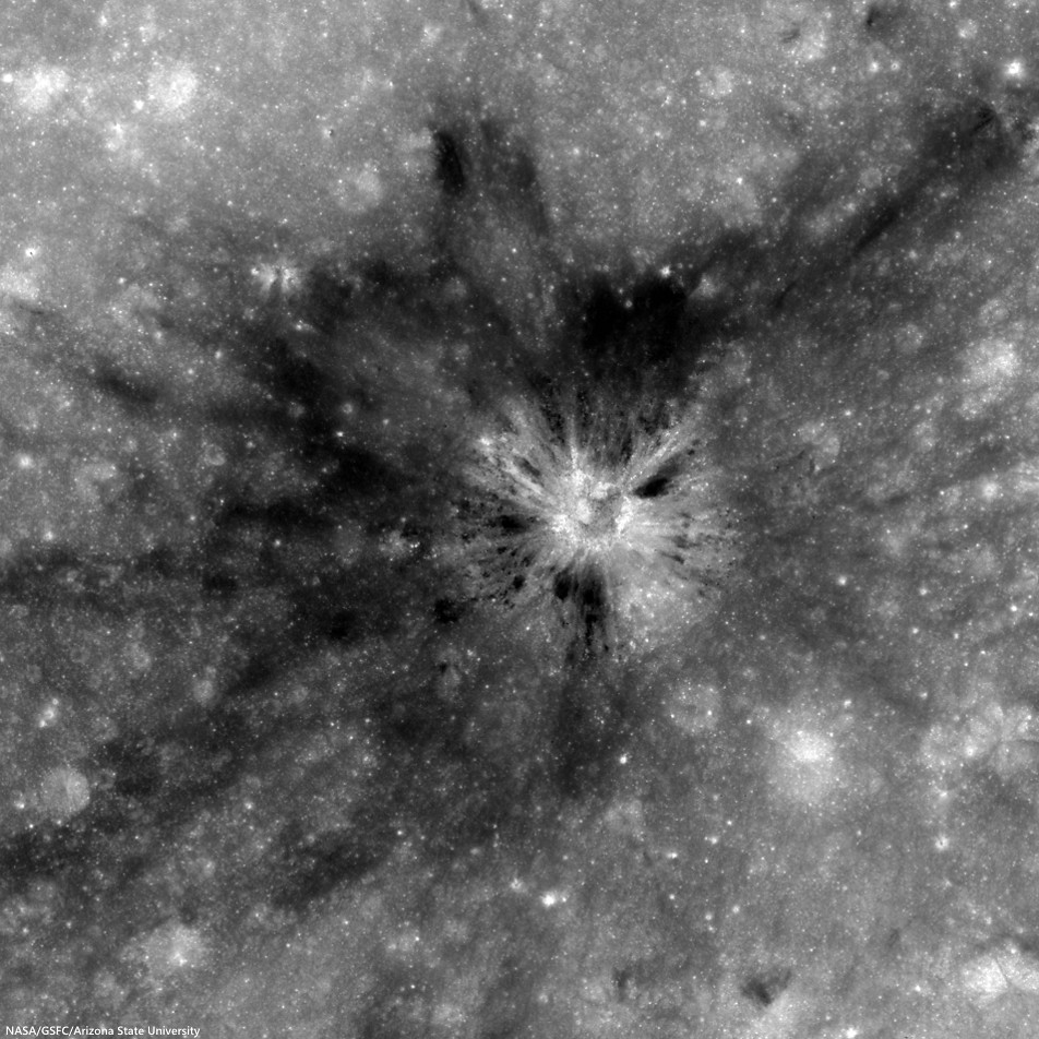
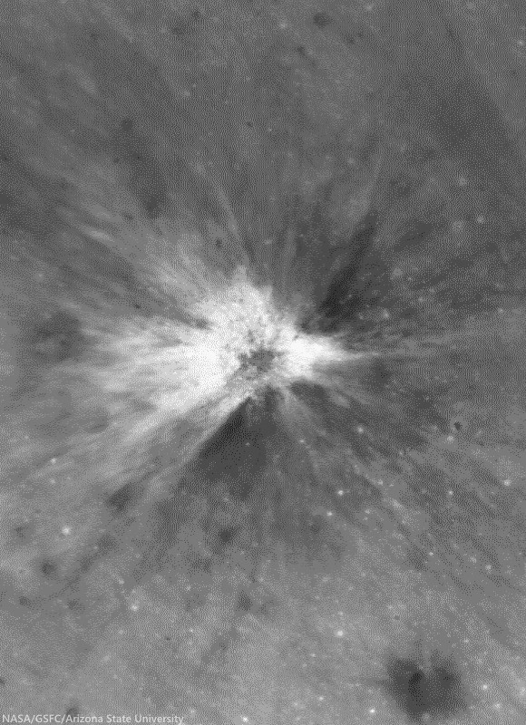
Unnamed crater (2.2784°N, 116.2125°E) southwest of King, presenting a unique albedo variation in 1.8 km-wide field of view from LROC NAC observation M123812230R, LRO orbit 3380, March 21, 2010; 8.3° incidence angle, resolution 57 cm from 55.36 km over 2.25°N, 116.16°E [NASA/GSFC/Arizona State University].
Hiroyuki Sato
LROC News System

Impact craters routinely excavate subsurface materials, exposing them in crater walls and in ejecta. The Featured Image highlights an unnamed fresh crater (480 meters in diameter) with numerous dark splotches.

Inside the crater cavity, dark splotches (low reflectance materials) occur from the middle to the trim of the crater and spread outward beyond the rim crest.

Several small craters (less than 100 meters in diameter) with similar dark splotches also occur in this region (outside the area shown above, see next image), suggesting that the dark materials were likely excavated from an extensive subsurface layer. The distribution of the dark halo craters informs us about the horizontal extent of these subsurface materials.

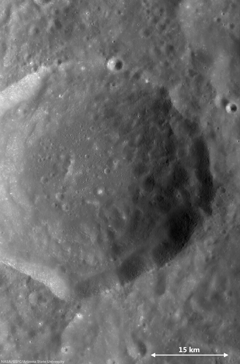
Small craters a few thousand meters north of the dark halo crater (DHC) of interest, above, from the same LROC NAC frame M123812230R. Note the crater right of center bottom may be superposed on the rim of a more ancient depression [NASA/GSFC/Arizona State University].
The crater in the opening image is found 116 km from the southwestern rim of King crater (76.2 km; 4.96°N, 120.49°E), located in the farside highlands. Unlike in the mare, pyroclastic deposits are unlikely to be the low-reflectance material (seen in the opening image) here in the middle of the highlands with no indication of volcanic activity near here. So, what is this low reflectance layer?

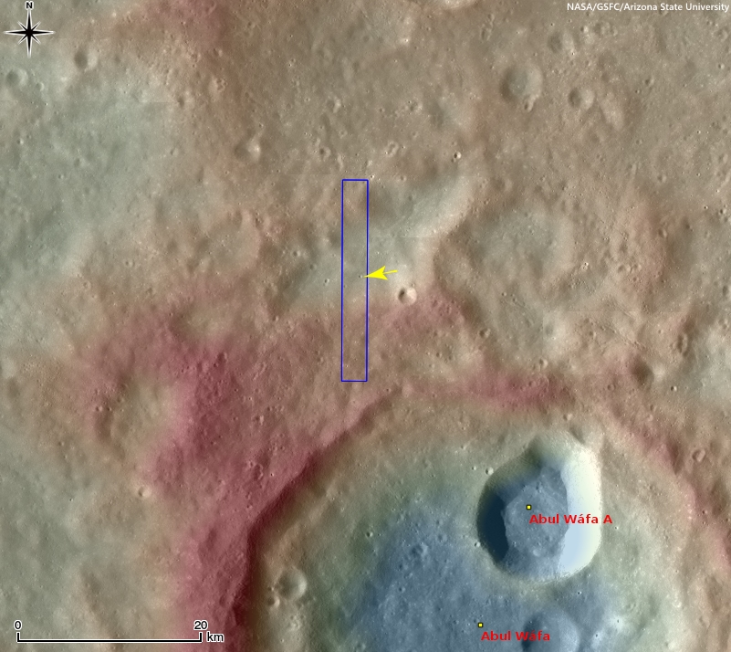
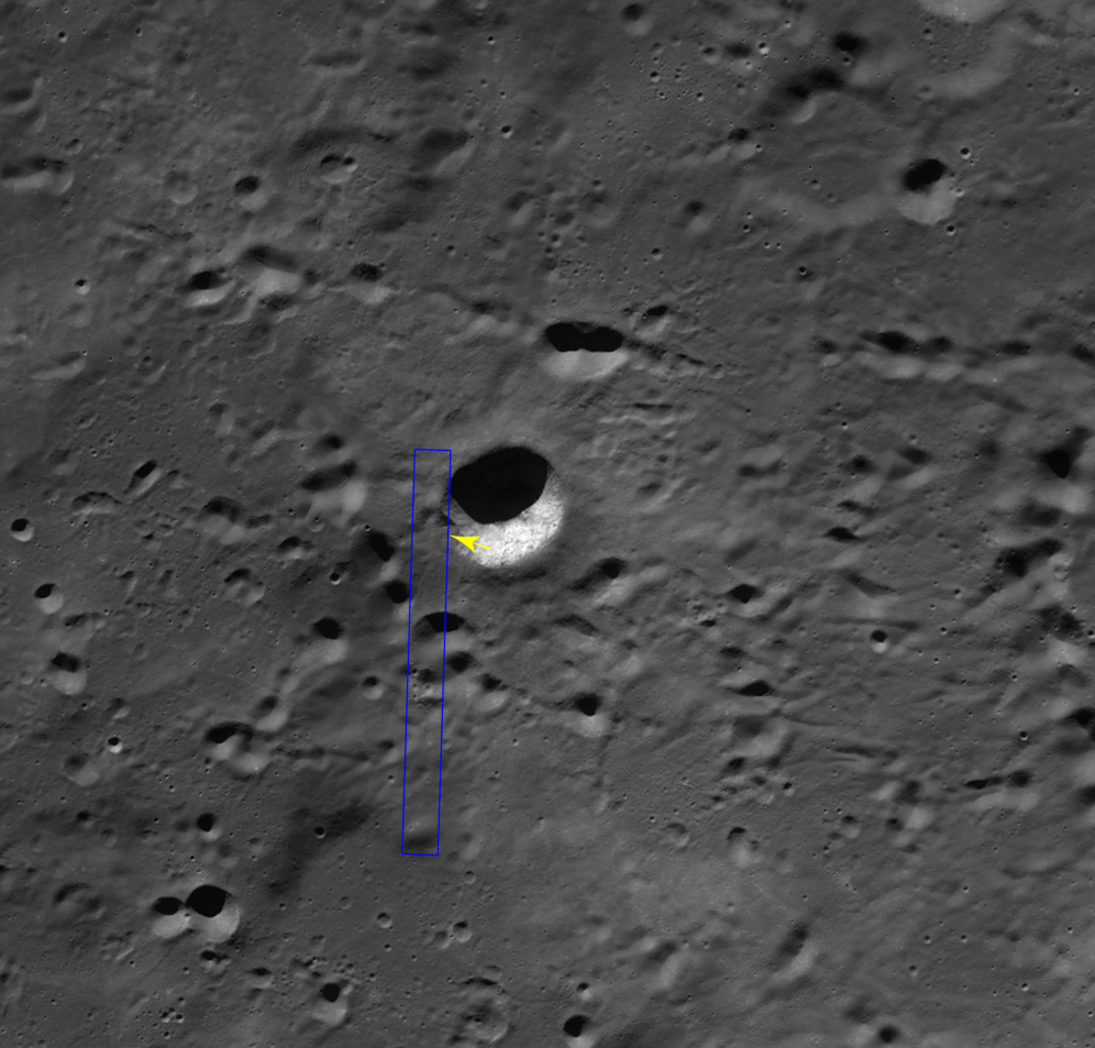
Context view of the location of today's Featured Image in WAC monochrome mosaic (100 m/pix) overlayed by WAC stereo DTM (GLD100, Scholten et al., 2012). The NAC footprint (blue box) and the exact location of the opening image (yellow arrow) are indicated [NASA/GSFC/Arizona State University]. 
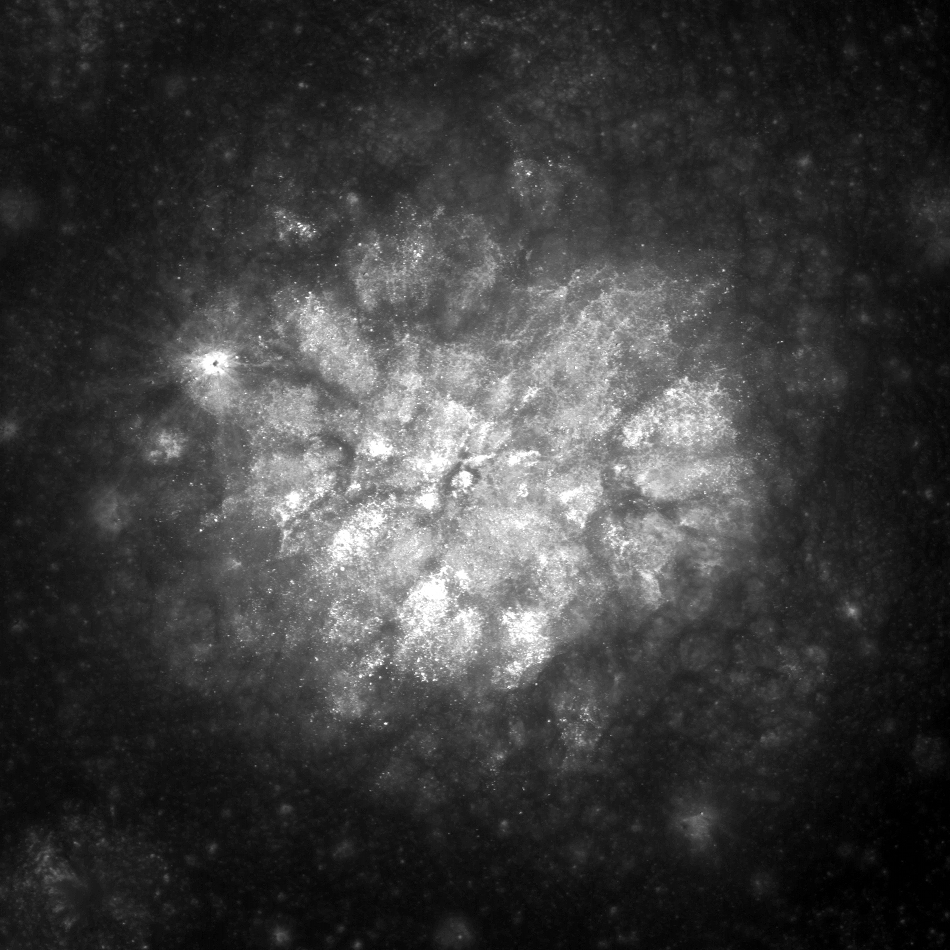
The rays of Necho crater (36.87 km; 5.25°S, 123.24°E) extend out around 680 kilometers (see image below) crossing over King crater and the area in today's Featured Image. Since the area of opening image is crossed by the Necho ray deposits the excavated dark layer might be the original mature surface (now covered by Necho's high reflectance rays).  

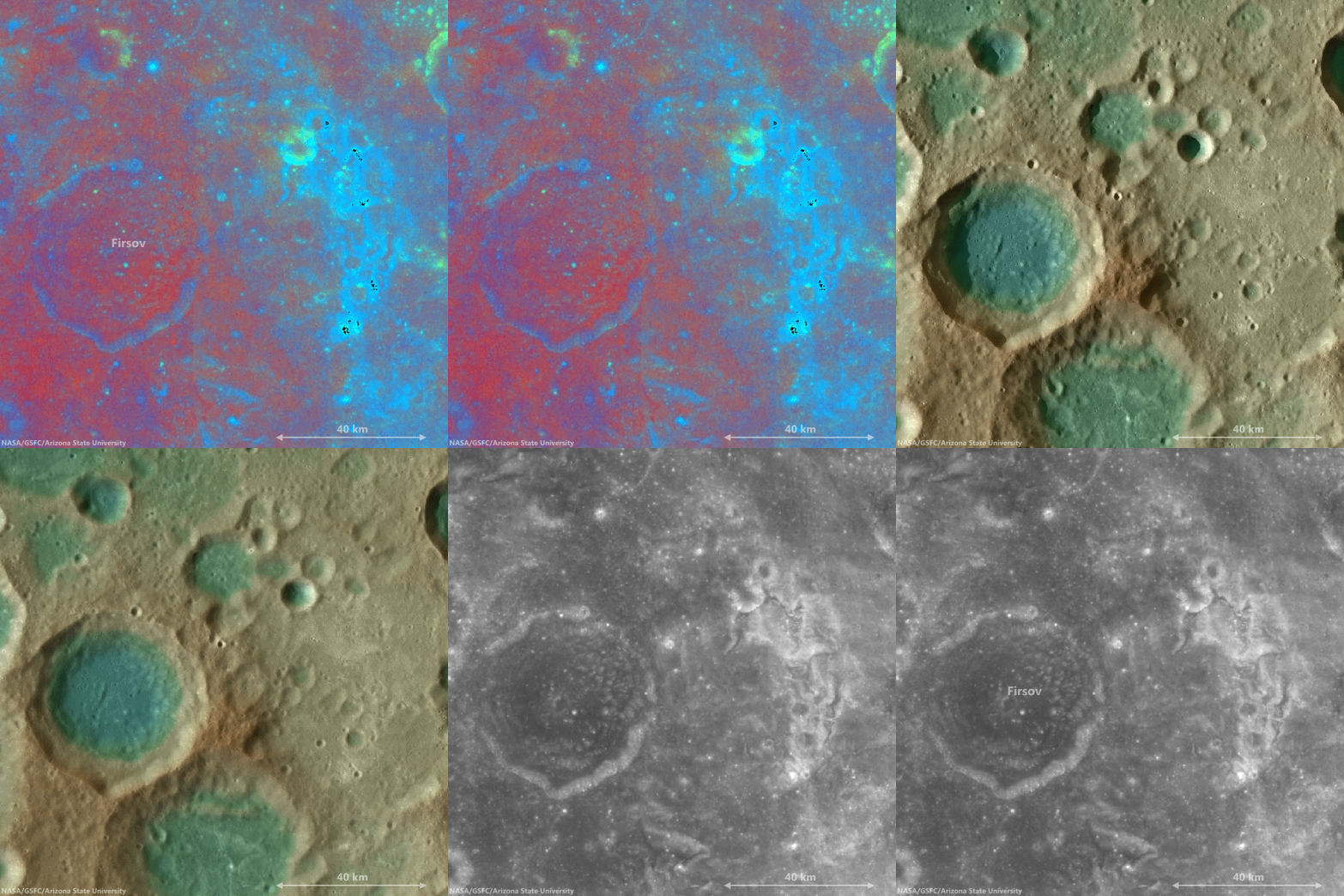
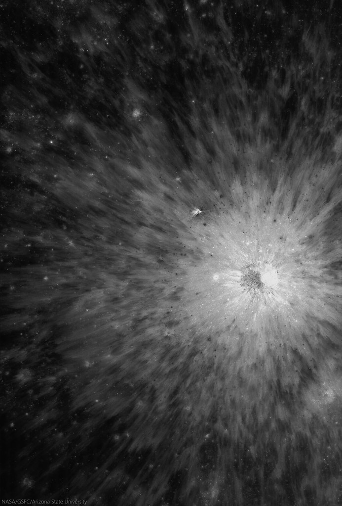
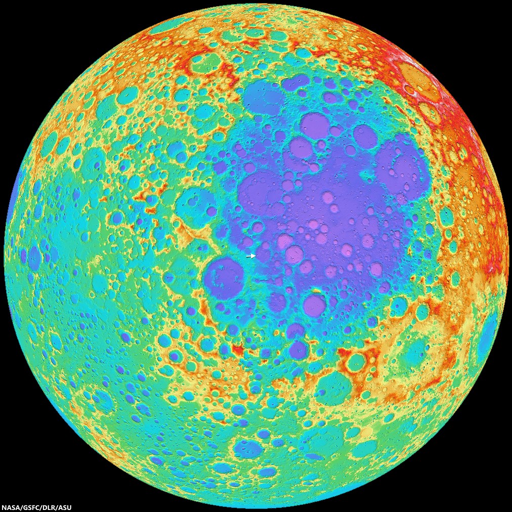
Context view of the area of interest in an orthographic LROC WAC mosaic of low-angle observations of the surrounding hemisphere. Arrow points to the location of the crater of interest, within range of ejecta from King, Necho or perhaps, less likely, Giordano Bruno or Goddard A craters, (not unlike the magnetic anomaly east of Firsov) [NASA/GSFC/Arizona State University]. 
Due to the lack of atmosphere on the Moon, the photometric effect is very strong. Thus, it is hard to identify the relationships between the different layers using low-Sun images (images with large incidence angles, near sunrise or sunset); however, high-Sun images (those with low incidence angles, near noon) display clearly the relationships between units, which helps us reconstruct the resurfacing history of this area.

View full-size view of the LROC NAC frame, HERE.

Related Posts:

Tuesday, November 18, 2014

Mottled mound at Firsov

Low-angle incidence view of a curious mound on the floor of Firsov crater (51 km; 4.204°N, 112.697°E). 2.2 km field of view from LROC NAC observation M187506567R [NASA/GSFC/Arizona State University].
Hiroyuki Sato
LROC News System

Firsov is a 51-km diameter crater located in the farside highlands, approximately 240 km east of King crater. The depth of Firsov's floor from the rim crest is an impressive 4.5 km (that’s 2.5 times the depth of the Grand Canyon in Arizona).

The bright (highly reflective) mound on the crater floor is about 200 meters in height, and 2.5 km in diameter, and really catches your eye. The central portion of the crater floor is relatively flat, suggesting that it at least partially consists of a long-solidified pool of impact-melt; the mound is located within this melt pond deposit.

46 km-wide field of view showing  the high-reflectance mound feature, near center of FriFirsovater, from LROC WAC monochrome (643 nm) observation M176892340CE, LRO orbit 11204, November 25, 2011; 62.51 incidence, resolution 58.62 meters from 43.41 km [NASA/GSFC/Arizona State University].
A number of previous Featured Image posts explored the origins of mounds occurring inside impact craters. Hypotheses include volcanic eruptions, impact debris, and the squeeze-ups of impact melt.

Today's Featured Image highlights the degradation of these mounds, instead of their origin. The low-incidence angle of the top image (~9°) highlights differences in albedo on the mound top, what causes these bright patches?

Perhaps, as the mound surface degrades over time, the high-reflectance materials are exposed unevenly, for example, due to a bumpy surface morphology, where local, topographically high portions are exposed faster and newly exposed material is immature (and thus brighter).

Alternatively, the mound may be constructed from non-uniform materials and/or compositions that exhibit a range of reflectivities. However, scientists believe that during impacts any compositional differences within the target are homogenized in melt deposits. This mound would be a great place to examine that hypothesis.

The bright mound southeast of center on the floor of Firsov is not the only albedo "anomaly" in the vicinity of Firsov crater. This cycle of overlapping fields of view, juxtapositioning data ranging from LROC WAC-derived elevation models to Clementine UV-VIS color ratio maps from 1994, brings into stark relief the unnamed Copernican era crater northeast of Firsov, and also the dramatic patch of albedo swirls coincident with a locally intense crustal magnetism, photographed from orbit by the crew of Apollo 10. It seems distant and detached, but still these swirls are likely associated with the widely-scattered swirl fields farther to the west at Mare Marginis, on the opposite side of the Moon from the energetic basin-forming impact that formed Mare Orientale 3.1 billion years ago [NASA/GSFC/Arizona State University].
View full-window, HERE.

Related Posts:
Shiny Mound
Kagami-mochi on the Moon!
Pancakes in a melt pond
Donut Holes
The Domes of Stevinus Crater
That's a Relief

Thursday, August 7, 2014

Dark Halo "Patch" west of Neper D

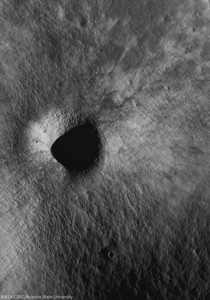
A roughly 470 meter wide, 560 meter long, unusually large and cohesive fan of dark halo ejecta from an unnamed but freshly prominent crater in the Neper group, southwest of Mare Marginis. 1020 meter-wide field of view from LROC NAC observation M1136029635L, LRO orbit 19510, October 10, 2013; 32.5° incidence, resolution 1.17 meters from 116.96 km over 8.73°N, 79.36°E [NASA/GSFC/Arizona State University].
Hiroyuki Sato
LROC News System

Today's Featured Image highlights an odd shape, or texture in impact ejecta. An unnamed, approximately 600 meter-wide fresh crater on a relatively high, far older crater rim, between Mare Marginis and Mare Undarum (9.5122°N, 79.40242°E) hosts teardrop-shaped low reflectance patches in its ejecta, northwest of the crater,

The larger teardrop patch in the opening picture has a sharp boundary along its western edge, perhaps implying a partially elevated surface relative to the surrounding high-reflectance ejecta.

4 km-wide field of view from LROC NAC observation M1136029635L, October 10, 2013 [NASA/GSFC/Arizona State University].
Note the faint high-reflectance ray overlying this patch, indicating that the low reflectance patch was emplaced before the completion of the impact event. Similar dark patches that are smaller and less pronounced are found at the top of the opening image.

How were these peculiar dark patches formed? If these patches are elevated, they could represent preexisting flat dark mounds that were swept by the saltating ejecta materials. Or the excavation of low-reflectance materials by the impact could have been thrown out in one direction and resulting in this unusual patch of ground. If, on the other hand, the patches are topographic lows rather than elevated, these depressions could have simply been shielded as the ejecta passed overhead. It is also possible that the topography of the rim controlled the direction of the outthrown ejecta such that there were "no ejecta" zones that resulted in the dark patches.
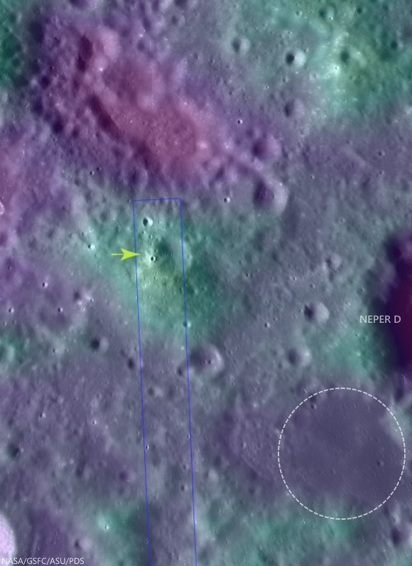
Fifty kilometer-wide field of view of the complex terrain southwest of Mare Marginis, west of Neper and Neper D. The unusually cohesive "fan" of apparent dark halo material from the unnamed relatively fresh 600 meter crater is marked at 9.5122°N, 79.40242°E (arrow) and may indicate the presence of now-buried optically mature material widely distributed in the area. The circle southwest of Neper D is a patch of isolated mare material bright in Clementine iron oxide surveys, often indicative of cryptomare.  Crater counts might eventually determine whether its age and whether or not this area is consistent with Mare Marginis or ejecta from the Crisium impact, or something much older. LROC WAC global 100 meter mosaic over LOLA laser altimetry [NASA/GSFC/ASU/USGS].
High resolution topography would really help unravel this mystery! NAC to the rescue! The LROC targeted this area for upcoming NAC stereo pairs from which meter-scale topography will be extracted. In a few months, we will post the topography and will see if we solved the mystery!

Explore this peculiar dark patch and surrounding terrain in the following full NAC frame, HERE.

Related Posts:

Tuesday, August 5, 2014

Fractures and boulders on the floor of De Forest

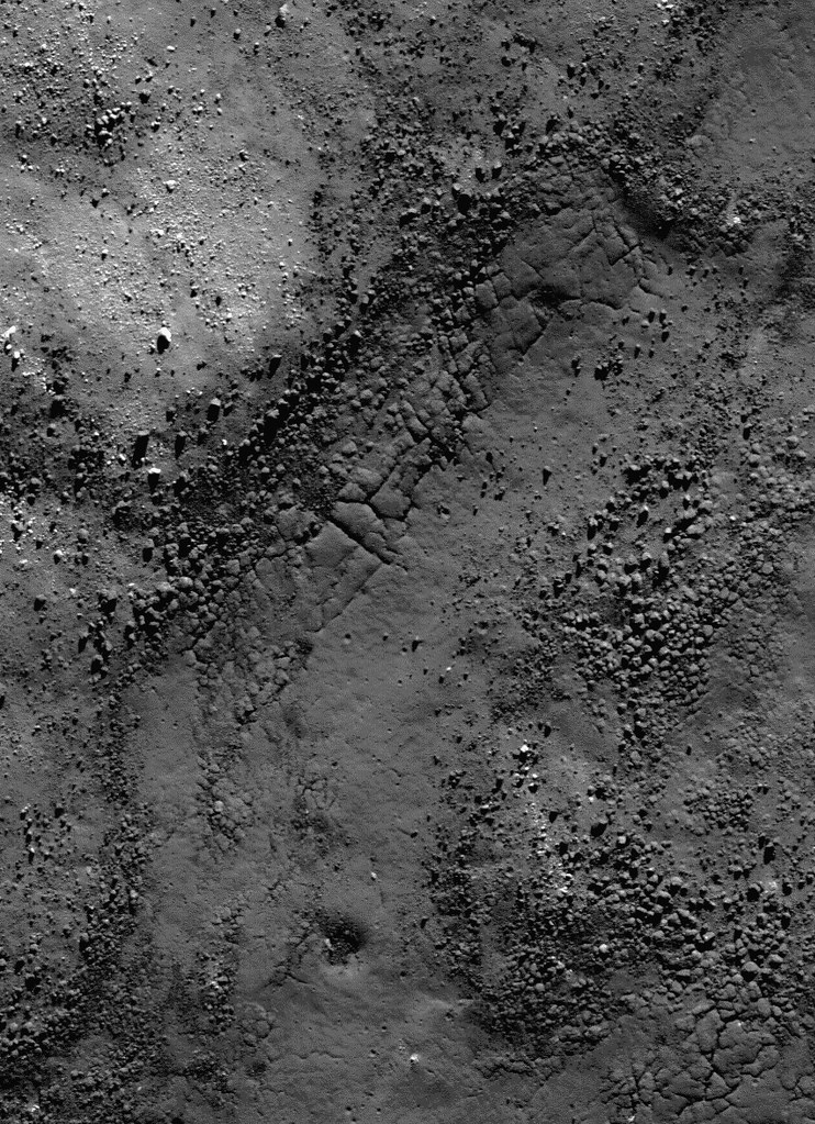
Fractured impact melt left the interior of De Forest crater (56.25 km; 76.94°S, 196.67°E) lined with boulders. 665 meter-wide field of view from LROC NAC observation M125650563L, 665 meter-wide field of view from LRO orbit 3650, April 11, 2010; 78.87° incidence angle, resolution 57 cm from 55.16 km over 77.1°S, 197.94°E [NASA/GSFC/Arizona State University].
Hiroyuki Sato
LROC News System

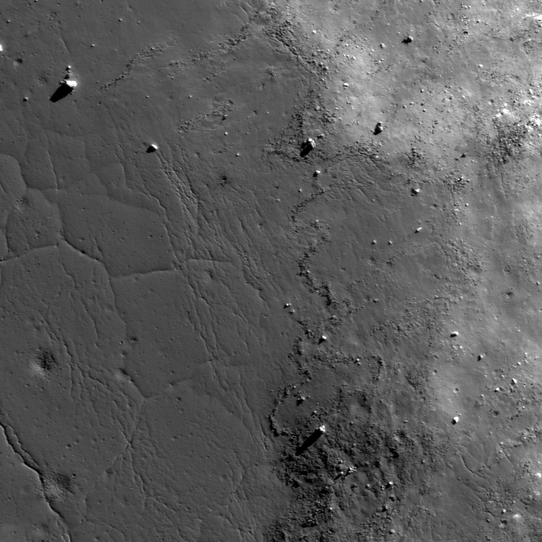
Today's Featured Image highlights a portion of the interior of De Forest crater (56.25 km; 76.94°S, 196.67°E), which is located inside the South Pole–Aitken basin.

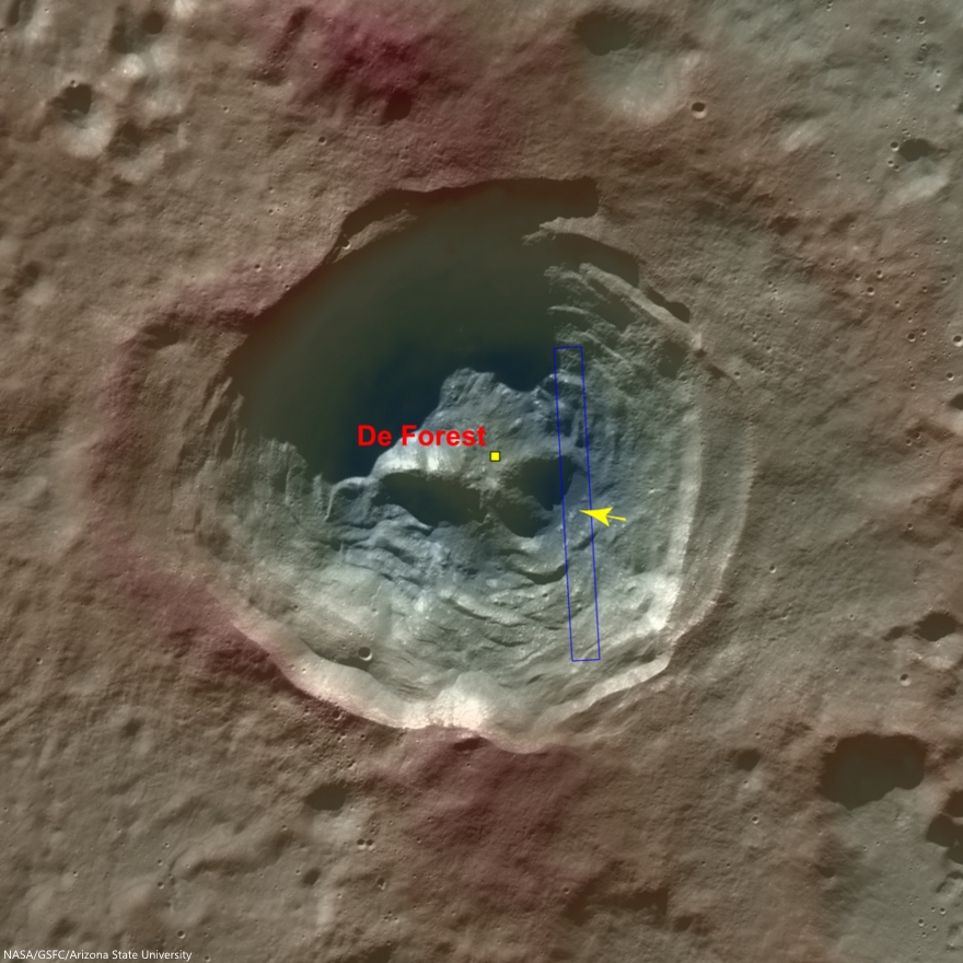
The cavity of De Forest crater exhibits prominent terraces of collapsed materials surrounding the central peak (see context imagery following).

The topographic low, east of the central peak, was largely coated with hot impact melt which formed a hard crust as it cooled; a portion of this melt is seen in the opening image. 

Context view of De Forest crater (56.25 km; 76.94°S, 196.67°E) consisting of LROC WAC monochrome mosaic (100 m/pix) overlain with colorized WAC stereo DTM (GLD100, Scholten et al., 2012). View centered on 76.92°S, 197.51°E. Footprint of LROC NAC observation M125650563L, April 11, 2010, outlined in blue, source of high-resolution view of the area designated with a yellow arrow (LROC Featured Image released August 5, 2014) [NASA/GSFC/Arizona State University]. 
Much of the area of the opening image is covered by numerous boulders, some of which are up to approximately 15 meters across.

The smooth surface extending in lower-left to upper-right is impact melt that cooled to form solid rock, and is now fractured in regular patterns along the edge. Impact melt that was splashed on the crater's walls and its central peak formed a coating that quickly cooled to solid rock.

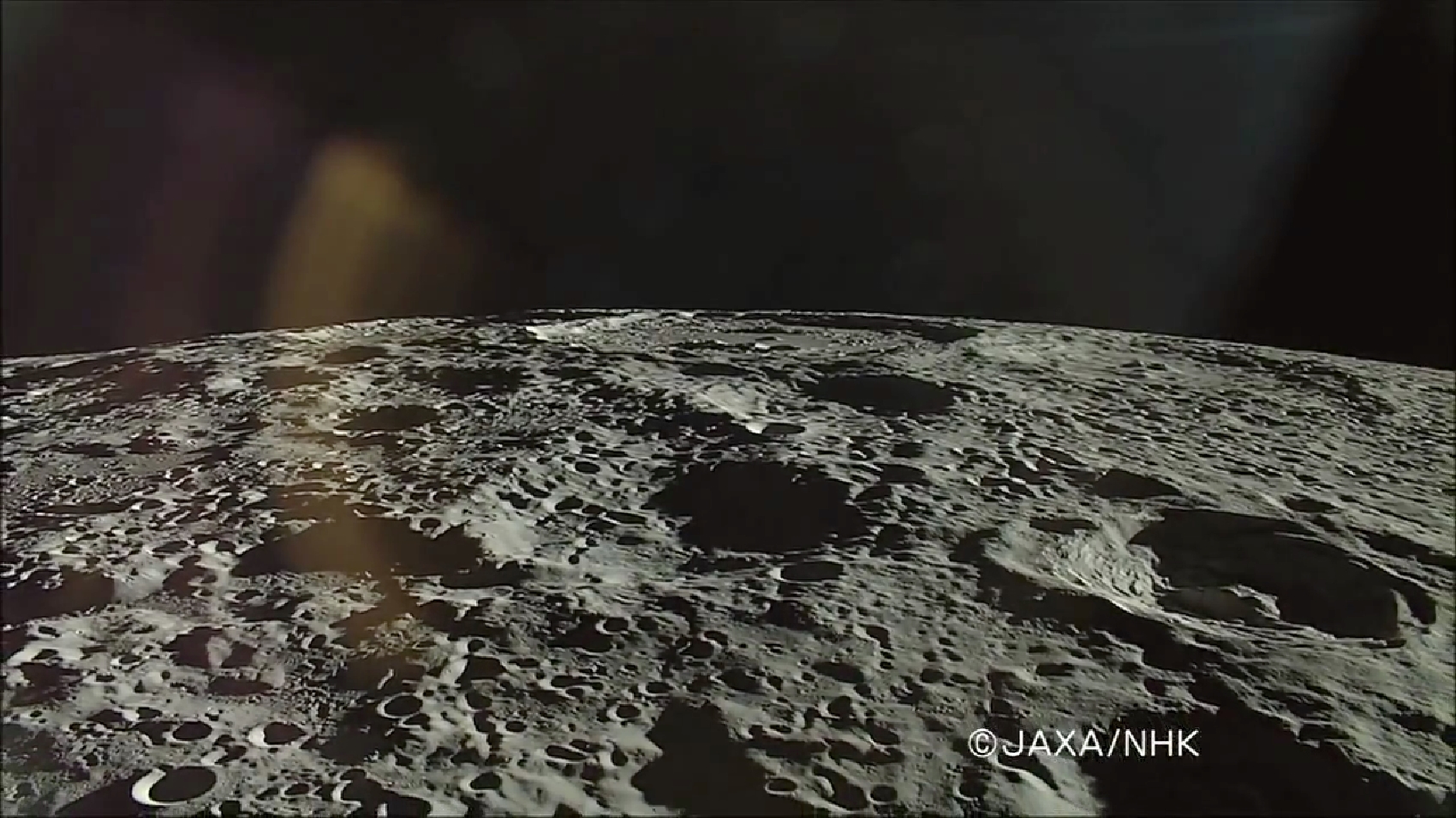
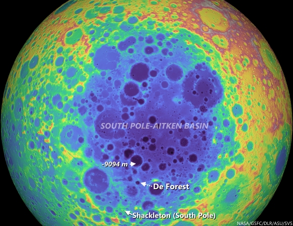
On the true "backside" of the Moon, De Forest (right) is situated well inside South Pole-Aitken impact basin, between Antoniadi (upper left, near horizon), host of the Moon's lowest elevation (-9094 meters) and Shackleton (not pictured), host of the Moon's south pole. HDTV still from Japan's lunar orbiter Kaguya (SELENE-1) in 2008 [JAXA/NHK/SELENE].
Later, it is likely that nearby moonquakes caused these brittle rock coatings to fracture, providing the source of boulders we now see on the lower reaches of the crater floor.

De Forest's position in the far south Farside is an area hosting Permanently Shadowed Regions (PSR's). The neutron detection experiment on-board LRO (LEND) has built up signatures consistent with cold-trapped volatiles, like water ice, in the vicinity. Image from Science Visualization Studio tour of SPA, larger image HERE [NASA/GSFC/Arizona State University/DLR/SVS]. 
As you can see in the following full NAC frame, an enormous number of similar boulders are found along the smooth melt deposits on the floor of De Forest crater. 

Explore this boulder-rich crater in the full NAC frame, HERE.

Related Posts:

Thursday, July 3, 2014

Sun angles, over fresh ejecta, east of Buisson V

Overlapping views of the same 1 km-wide area of the lunar surface, immediately southwest of a fresh impact crater near Buisson V; 68° morning shadow and 8° mid-day albedo, respectfully. LROC NAC observations M146255155R (LRO orbit 6687, December 6, 2010; incidence 67.86° at 62 cm resolution from 60.47 km) and M187520776L (orbit 12701, March 27, 2012; 8.35° incidence, resolution 97 cm from 116.95 km) [NASA/GSFC/Arizona State University].
Hiroyuki Sato
LROC News System

Today's Featured Image highlights differences in how the surface appears as the Sun angle changes. As seen in the opening image, the two images show the exact same area, but their appearances are remarkably different. Both images show the southern portion of the ejecta from an unnamed fresh 1 km crater (0.4933°S, 110.7156°E, 9.8 km west by northwest of Buisson V, an ancient equatorial crater just beyond the east limb.

The darker image, highlighting the granularity and elephant skin texture of the surface, was acquired when the Sun was low on the horizon (incidence angle = 68°), and the image characterized by bright swaths of ejecta was acquired when the Sun was nearly overhead (incidence angle = 8°).  Both were acquired with the cameras looking straight down. The small crater (about 27 meters in diameter) in the upper-middle each segment is a good landmark to confirm both images show the same location. 

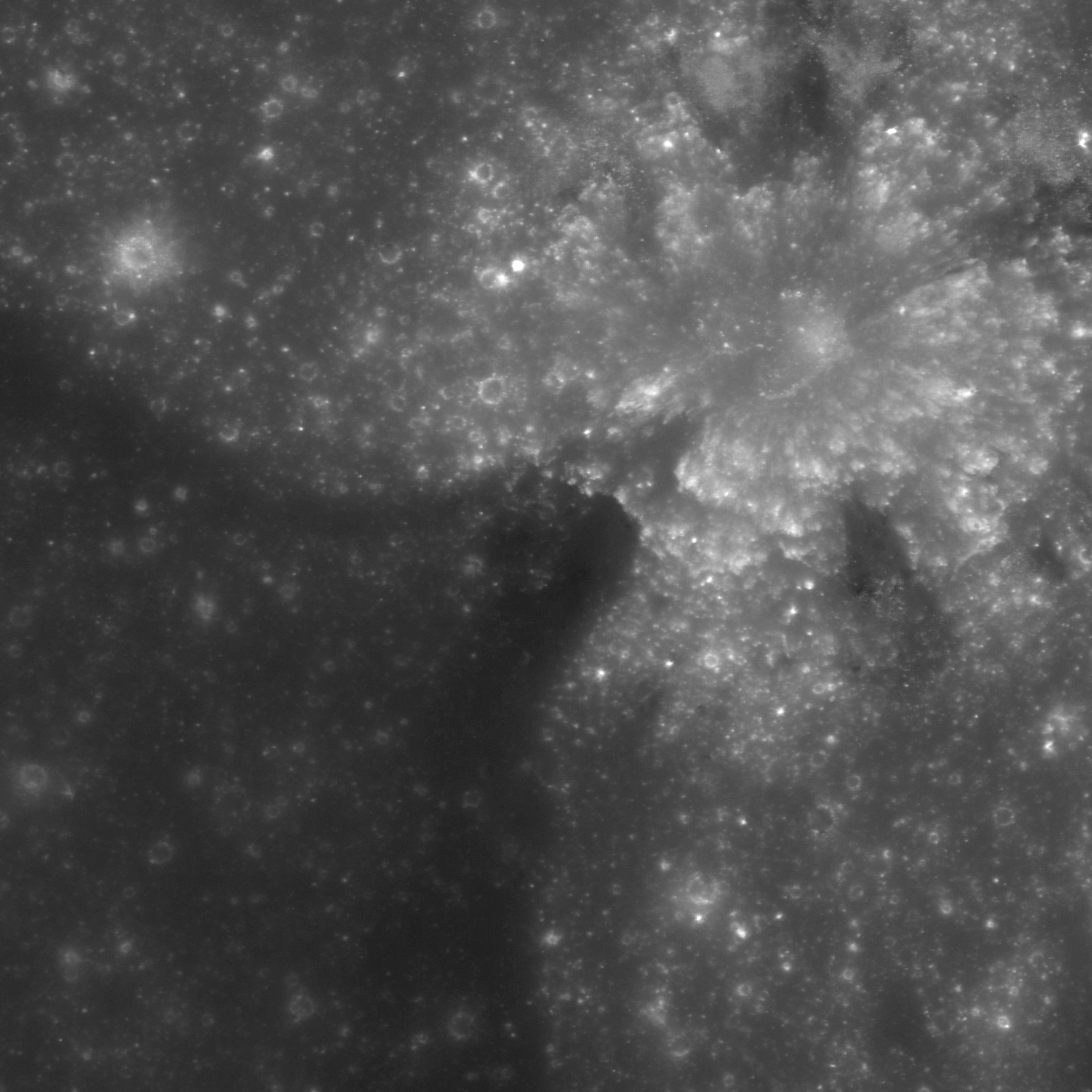
Context view of ejecta blanket, source unnamed fresh crater (0.4933°S, 110.7156°E) 9.8 km west by northwest of Buisson V. LROC NAC footprint fields of view designated, area shown at high resolution indicated with an arrow. 46.1 km-wide field of view from LROC WAC monochrome (604 nm) observation M176905846C, LRO orbit 11206, November 26, 2011; 62.67° incidence, resolution 58.44 meters from 43.14 km [NASA/GSFC/Arizona State University].
When the Sun is high no resolvable shadows are cast, and surface brightness (albedo) variations stand out. The low Sun image has sharp shadows, highlighting the surface texture. Due to these drastic changes caused by the Sun angle scientists use NAC images at specific lighting conditions for different studies, of morphology, composition, optical and molecular maturity, topographic mapping, etc).

Granularity, at the expense of albedo, becomes visible at relatively low sun (high incidence angles). See the image at higher resolution HERE.
Related Posts:
LROC Coordinates of Robotic Spacecraft - 2013 Update
Polka-dot Ejecta
Ejecta sweeps the surface
Dynamic Textures
Action Shot
Peary Crater: Greetings from the North Pole of the Moon

Thursday, June 12, 2014

Study in superpositioning at Vavilov D

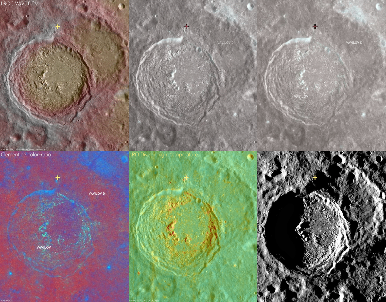
Sunrise, sunset. LROC NAC observations 10 months apart, one at local sunset and the other after local sunrise, both from nearly identical altitudes and resolutions, capture these views of double "dingleberries," drops of hot melt, very likely from the impact that created Vavilov crater, sit where they quickly flattened and cooled, just inside the steep slope of ancient Vavilov D. The Vavilov craters are a study in stratigraphy and superposition [NASA/GSFC/Arizona State University].
Immediately inside the northwest rim of highly degraded Vavilov D, twin disks of impact melt, likely from the formation of Vavilov, came to a standstill at the upper end of a contiguous slope of 5000 meters elevation, over about 40 km, into the complex floor of the latter Eratosthenian crater. This 1400 meter field of view (down slope is to the lower right, centered on 1.14°N, 221.536°E) from LROC NAC observation M1128031686L, LRO orbit 18385, July 9, 2013; 61° incidence angle, resolution 1.17 meters from 114.6 km [NASA/GSFC/Arizona State University]. 
Hiroyuki Sato
LROC News System

Vavilov D is an heavily degraded crater (96.1 km; 0.026°N, 220.93°E) sits between the Orientale basin and Jackson crater, both of which it may pre-date.

The later formation of the nearly identical, over-lapping Vavilov crater (98.2 km; 0.87°S, 221.23°E) eradicated the entire southwestern half of Vavilov D.

The second image above spotlights a spot on the northwestern curve of the wall of Vavilov D near where the Eratosthenian Vavilov erased the older crater's anatomy. The relatively smooth textured area in the upper left corresponds to the outside of Vavilov D, and the rest of rough/craggy surface is the interior crater wall's steep slope. 

The two degraded craters (~280 m in diameter) near the middle of the opening image exhibit fascinating overlying smooth features that may have formed as material flowed downslope (arrows).

View the full-resolution original HERE. The twin melt disks are located where the rim of Vavilov superseded that of Vavilov D, in the farside equatorial highlands,  where Vavilov is etched into terrain 8000 meters above the global mean elevation. It's possible an astronaut could walk from this location south into the interior of Vavilov. 5.6 km-wide field of view from LROC NAC observation M1128031686L [NASA/GSFC/Arizona State University].
Other morphologic pits/dents on this slope also have similar textures. What we are seeing here are most likely remnant impact melt that was thrown out of the Vavilov crater. Craggy sloped surfaces with patches of smooth material are often found associated with young impact craters -- formed as impact melt flowed over and around the newly formed crater.

The deepest material brought to the surface by impacts on the Moon is found on the resulting crater's rim. A fresh crater near our area of interest, on the rim of Vavilov D (cross), exposes material excavated by that ancient impact, and Vavilov D, in turn, is nested on the Hertzsprung basin. The larger region is also at the outside range of the majority of secondary craters from the Orientale basin-forming impact. LROC Quickmap mosaic [NASA/GSFC/Arizona State University].
Depth of field in lunar photography is a fleeting quality. With the LROC WAC-derived elevation model (GLD100), however, the super-positioning of Vavilov D (and an aeon or two later, Vavilov) on Hertzsprung is much easier to detect, along with some of the most extreme elevation ranges, some 9 km above the global mean [NASA/GSFC/DLR/Arizona State University].
Related Posts:

Tuesday, June 10, 2014

Ready-made excavations near Lucretius C

Self-secondary of a bright, relatively fresh crater northwest of Mare Orientale, in the wider highlands greatly affected by that basin-forming impact. The unnamed primary crater (between Lucretius C and Grachev craters, see below) is visible from a great altitude because of its relative low optical maturity. Full-resolution, 530 meter-wide field of view from LROC NAC observation M1132582647R, LRO orbit 19028, August 31, 2013; 9.47° incidence angle, resolution 92 cm, from 106.13 km over 3.09°S, 246.92°E [NASA/GSFC/Arizona State University].
Hiroyuki Sato
LROC News System

Today's Featured Image highlights the spectacular fresh ejecta from an unnamed crater (1.05 km; 3.06°S, 297°E), approximately 750 km northwest of Mare Orientale.

Subsequent impacts (possibly including self-secondaries) excavate through the ejecta sheet, leaving small craters, mostly less than 50 meters in diameter, and tiny ejecta splashes.

Some are lower and others are higher in reflectance than their surroundings, resulting in a variety of contrasts against the bright, optically immature ejecta field of the primary crater. 

Bright, relatively fresh primary to highlighted secondary crater at upper left northwest of Orientale basin, between Lucretius C and Grachev. 4.54 km-wide field of view from full-width of LROC NAC observation M1132582647R, visible HERE. [NASA/GSFC/Arizona State University].
In the opening image, many small high reflectance craters (~10 m) are clustered at the lower right side of the image, while nearby mid-sized craters (~50 m) are darker than their surroundings. The largest crater's ejecta (center-left in this image) is composed of two layers, the brighter layer on top of the darker layer.

Full-width mosaic, 13.357 km-wide field of view from a mosaic of both the left and right frames of LROC observation M1132582647.   Larger reproductions are available HERE [NASA/GSFC/Arizona State University].
These reflectance variations are likely due to the different excavation depths into the low and high reflectance surface and subsurface deposits. The mid-sized craters probably reached the original low reflectance materials below the upper higher reflectance ejecta sheet (from the unnamed ~1km diameter crater). The largest crater likely excavated high reflectance substrate that is also exposed on the unnamed crater's wall. 

250 meter resolution view shows the high visibility of the small crater of interest (1.05 km; 3.03°S, 297°E), against the ancient highlands, deeply scared by the energy of the Orientale basin-forming-impact. LROC Quickman WAC natural color beta over 100 meter global mosaic [NASA/GSFC/Arizona State University].
Context for high resolution LROC NAC view of bright fresh 1.05 km crater (3.06°S, 297°E) northwest of Mare Orientale [NASA/GSFC/SVS/Arizona State University].
Impacts serve as a natural excavation process which helps us to glimpse into the otherwise unreachable geological layers on the Moon. 

View full-width mosaic, HERE.

Related Posts

Thursday, April 24, 2014

Angular ejecta edge in the farside highlands

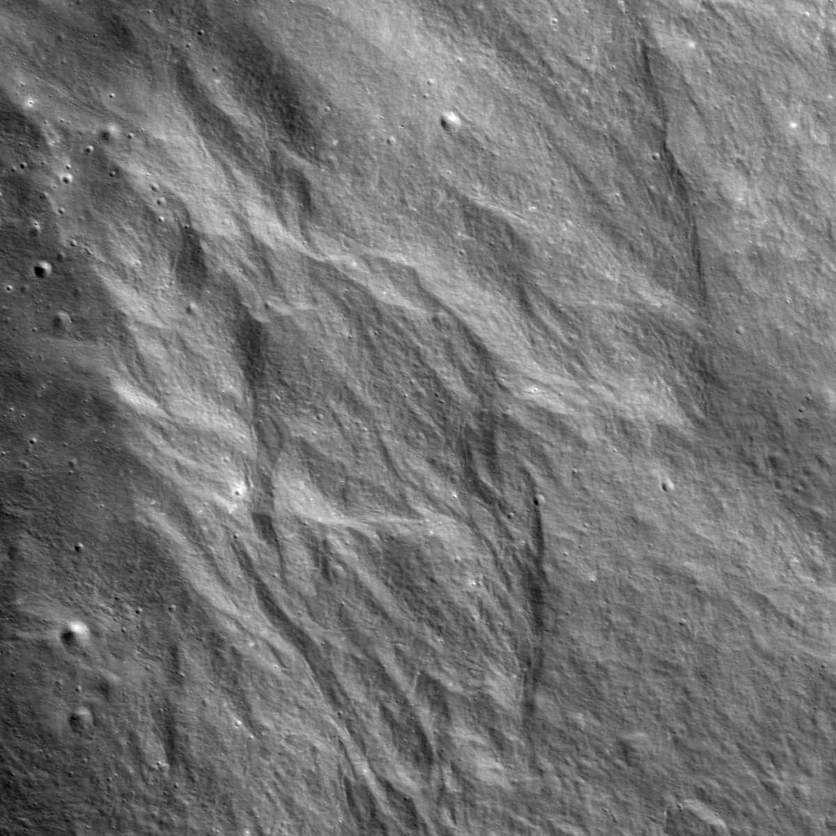
Ejecta flowed down an unnamed crater wall leaving behind this spectacular pattern. LROC NAC M1145938700LR, LRO orbit 20904, February 2, 2014; 44.1° incidence angle, resolution 1.29 meters - 1800 meter field of view centered on 34.653°N, 187.234°E; width is 1800 m, downslope is to the lower-right, north is up [NASA/GSFC/Arizona State University].
Hiroyuki Sato
LROC News System

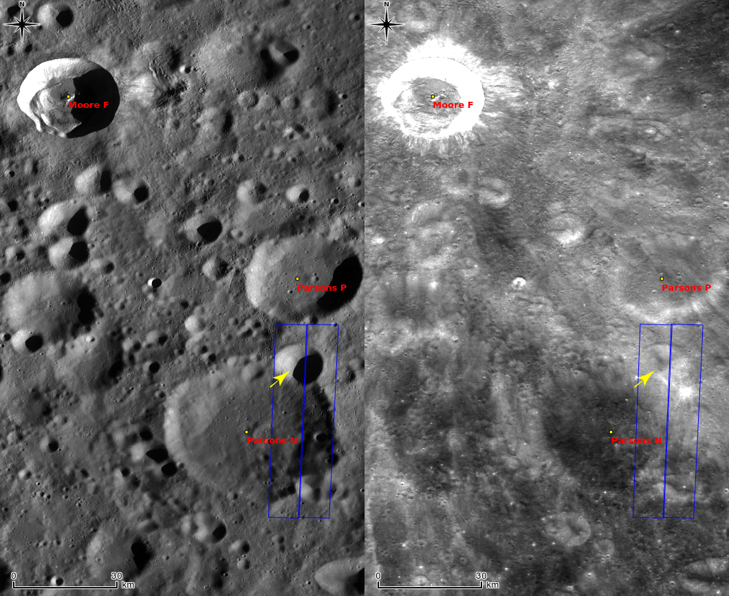
Today's Featured Image highlights the spectacular pattern left behind by ejecta rushing downslope across rough topography. As seen in next WAC context no-shadow mosaic, this area is extensively covered by fresh (high reflectance) ejecta from Moore F (~23.8 km in diameter), about 90 km northwest from the opening image. In fact the area around the image is peppered with Moore F secondaries, the beautiful terrain here may be ejecta from these secondaries.

The steep walls of this unnamed crater allow the ejecta material to travel further as a ground hugging flow, than if it had landed on a flat surface. At the distal edges of these ejecta deposits we see angular flow features (the opening image), likely formed by locally accelerated flow conditions (due to steep slopes). Unlike the flat and smooth mare surfaces, the slope-rich bumpy highlands create various flow conditions, which result in distinctive morphologies that help lunar scientists understand resurfacing processes on the Moon. Especially the importance of ground hugging flows.

Context view of ejecta inside an unnamed crater on the northeast rim and wall of Parsons N, in comparison LROC WAC monochrome mosaics (left, in sunrise shadow, right: native reflectance albedo). Field of view centered near 35.43°N, 186.26°E; width is about 86 km. The footprint (blue box) for LROC NAC observation M1145938700LR and the location of the LROC Featured Image released April 24, 2914 (yellow arrow) annotated [NASA/GSFC/Arizona State University].
Explore the strange angular shaped ejecta deposits in full NAC frame, HERE, and in LROC QuickMap, HERE.

Related Posts:
Delicate patterns in Giordano Bruno ejecta
Ground Hugging Ejecta
In the Wake of Giordano Bruno
Smooth Ejecta

Tuesday, April 22, 2014

Impact on an old and steep slope

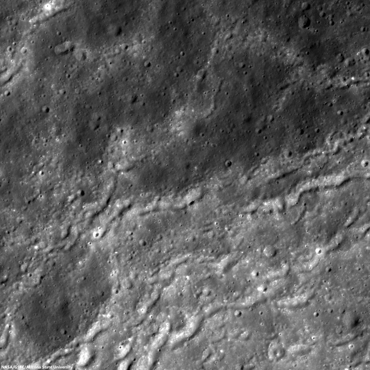
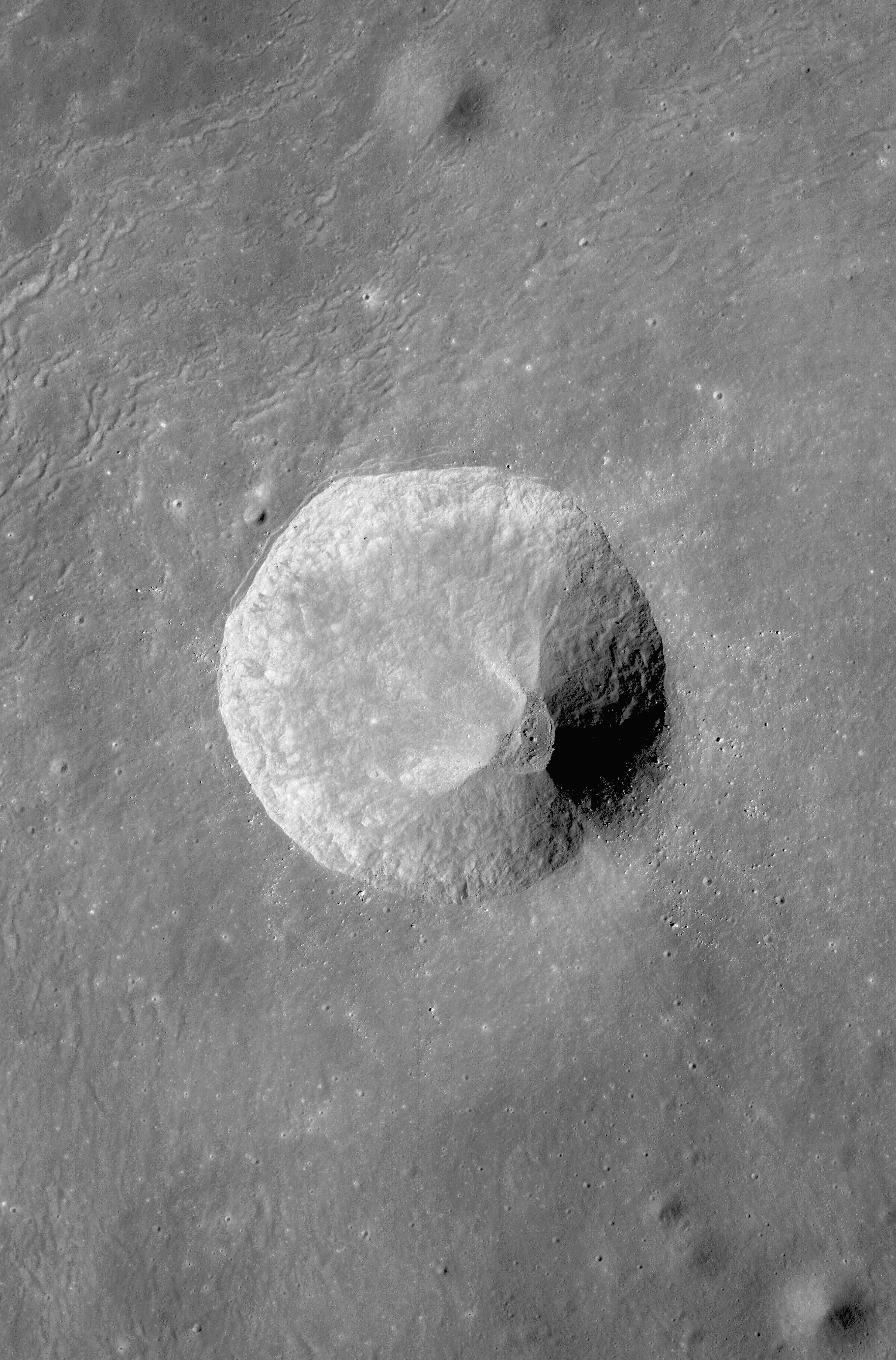
Unnamed crater ejecta, within Dante C, field of view 1728 meters, centered on 28.463°N, 182.491°E, downslope is to the lower-right.  From LROC NAC observation M1137707212L, LRO orbit 19746, October 29, 2013; angle of incidence 57.33° resolution 1.44 meters from 143.84 km [NASA/GSFC/Arizona State University].
Hiroyuki Sato
LROC News System

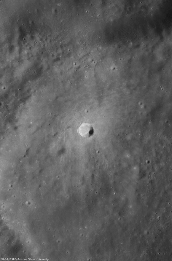
Dante C is a ~54 km diameter crater, located in the central farside highlands. In the northwestern portion of the crater floor, there is an unnamed crater (about 3 km in diameter) with a spectacular diffuse asymmetric ejecta pattern (see next WAC no-shadow context view, right side).

The uphill side (upper-left) shows a distinctive wavy pattern of ridges and grooves (seen in the opening picture) within about 3 km of the rim.

Probably due to the background slope (Dante C crater wall, downslope is to the lower-right), the ejecta hit the ground and stopped in a shorter distance than on the downhill side, leaving partially wrinkled edges in the ejecta deposits.

Wider, 6.14 km-wide field of view, context for area of interest at far upper center, left, from LROC NAC mosaic M1153033874RL, LRO orbit 21901, April 25, 2014; incidence angle 58.14° resolution 1.45 meters from 146.22 km over 29.17°N, 182.54°E [NASA/GSFC/Arizona State University].
33.1 km-wide field of view from LROC Wide Angle Camera monochrome [604 nm] mosaic, swept up over three sequential orbital passes, LRO orbits 11135-11137, November 20, 2011; average incidence angle 60° at 57 meters resolution, from 43.84 km [NASA/GSFC/Arizona State University].
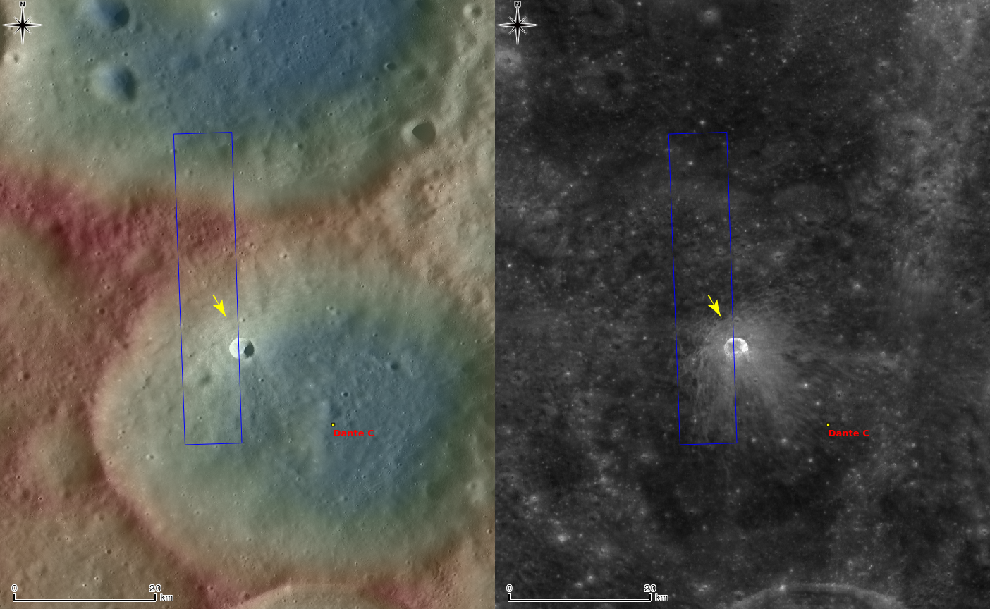
Context view of Dante C crater and surroundings, LROC WAC monochrome mosaic overlayed with DTM with GLD100 at left, and WAC normalized reflectance at right (100 m/pix). Image centered on 28.57014°N, 182.63728°E, field of view 62 km. The location of area shown at high-resolution in LROC Featured Image released April 22, 2014 designated with arrow [NASA/GSFC/Arizona State University].
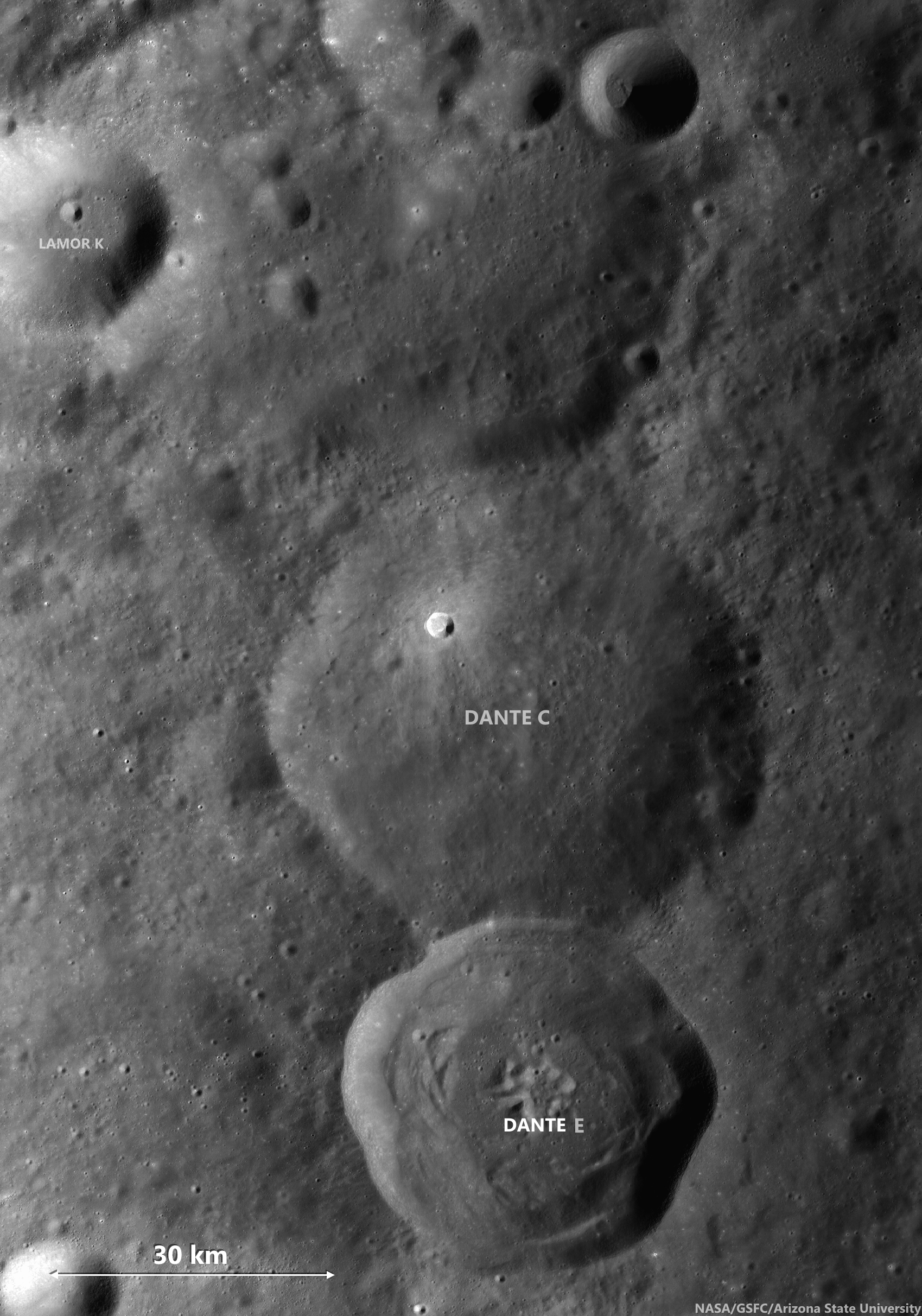
97 km-wide field of view from the same LROC Wide Angle Camera monochrome [604 nm] mosaic, swept up over three sequential orbital passes, LRO orbits 11135-11137, November 20, 2011 [NASA/GSFC/Arizona State University].
The downhill side shows a smooth surface without the wavy pattern, implying that the thin layer of ejecta spread out homogeneously on the downslope. Also, the thickness of the ejecta itself might have been asymmetric due to the local slope. The uphill slope can interrupt ejecta's lateral motion, leaving unique ridges and grooves, another example of the range of crater forms found on the Moon.

Craters like Dante C disappear under low-angle sunlight. Fresh rays from much younger craters, like Jackson, and even a young crater on its northwest interior, outshine such a very ancient crater. View the full size 1000 px original gif file, HERE [NASA/GSFC/Arizona State University].
Explore the asymmetric ejecta with clear wave patterns in full NAC frame, HERE and in LROC QuickMap, HERE.

Related Posts:
Impact Art
Bright and Dark Ejecta
Dynamic Textures
Ejecta Patterns
Lassell D Ejecta
In the Wake of Giordano Bruno
Ground Hugging Ejecta

Thursday, March 27, 2014

Distal Edges in the South Pole-Aitken basin

Blocky fences, like debris on a beach marking high water, border impact melt pools on the rim of an unnamed fresh crater on the vast floor of the ancient South Pole-Aitken impact basin, in jumbled terrain between Antoniadi and Schrödinger basin. 816 meter-wide field of view from LROC NAC observation M112884286R, LRO orbit 1759, November 15, 2009; resolution 66 cm per pixel, far south illumination incidence angle 75.9° from 63.93 km. The long axis of the large boulder at upper right is approximately 120 meters in length [NASA/GSFC/Arizona State University].
Hiroyuki Sato
LROC News System

Today's Featured Image highlights striking forms on the outside rim of an unnamed young crater (~11 km in diameter; image center 71.425°S, 161.88°E; incidence angle is 75.9°) located 140 km east of Schrödinger basin.

The western flank of this small crater is dappled with multiple impact melt ponds (now solidified into rock) inhabiting local topographic depressions.

The surfaces of the ponds show polygonal patterns of fractures that likely formed as the melt cooled and solidified (and thus shrank). The organized pattern of boulders (looking somewhat fence like) formed along a flow front.

Since these lines of boulders rest on top of impact melt rocks they show that melt was splashed out at least two times during the crater forming event.

Context view of the unnamed 11 km-wide crater and vicinity. LROC WAC 100 meter monochrome mosaic, centered on 71.36°S, 162.91°E; field of view roughly 45 km. LROC NAC M112884286R footprint outlined in blue, location of the area of interest shown at high resolution, in LROC Featured Image released March 27, 2014 marked by arrow NASA/GSFC/Arizona State University].
The later splashes barely made it out of the crater and flowed only a short distance. What caused this last splashing of melt? Perhaps a large landslide on the interior wall fell into a lake of melt at the bottom of the crater and caused a big splash.

Short melt flows are common around lunar craters -- they tell a tale of the incredible forces unleashed during cosmic collisions. These same events happen as often on the Earth as the Moon. But why do we see so few impact craters on the Earth? Earth has a lot of resurfacing (erosion, weathering, volcanism, plate tectonics), and weathering or resurfacing on the Moon is a lot slower. Thus, more craters and melt deposits are preserved on the Moon.

The unnamed fresh crater between the deep crater Antoniadi and the Moon's youngest impact basin Schrödinger (edge at extreme lower left), on the vast floor of South Pole-Aitken basin, features terraced pools of impact melt more typical of much better known and studied craters, like Tycho, in the mid-latitudes of the nearside [NASA/GSFC/Arizona State University].
Enjoy the fascinating impact melt features around this young crater in full NAC frame, HERE.

Related Posts:
Tycho's flash-frozen inferno
Breached Levee
Splash Mark
Scalelike Impact Melts
Impact Melt Lobes
Herigonius K Impact Melt Flow
Waves

Situated between Antoniadi, home to a crater with the lowest elevation on the Moon, and Schrödinger basin, the fresh crater of interest is of an age and size (like similarly-sized and situated Shackleton) is generally more typical of mid-latitudes, a feature of the Moon's history of bombardment (and, thus, of the the Solar System) that's evidence of diminishing size and frequency of impacts over time, and more originating from the direction of the ecliptic. Exploration of the crater may afford an opportunity to sample deeper history. Hemispheric projection of LROC WAC-DTM topography centered on the area of interest [NASA/GSFC/DLR/ASU].

Tuesday, February 25, 2014

Dark patch enigma in Mare Smythii

Splash of dark material
Low reflectance materials splashed out from an unnamed crater, 1260 meter-wide field of view centered on 2.322°S, 81.725°E, incidence angle 3.3°   From an Narrow Angle Camera observation swept up over the far western interior of Mare Smythii, LRO orbit 19177, September 12, 2013. LROC NAC M1133662942L [NASA/GSFC/Arizona State University].
Hiroyuki Sato
LROC News System

Today's Featured Image highlights an unnamed fresh crater, about 700 meters in diameter, found on the western edge of Mare Smythii.

The low reflectance materials extend out in an distinctive bell shaped pattern from the southwestern edge of the crater rim. The interior crater wall near this deposit also shows splashes of relatively darker materials, as well as three other dark patches (at 12, 2, and 5 o'clock, relative to the crater center).

These deposits are likely similar in nature to the excavated dark deposits emplaced near the rim, and they appear to have partially flowed back into the cavity.

Full LROC NAC enigmatic splash in Mare Smythii
Enigmatic low reflectance material and surroundings in the context of the full 7.2 km width of LROC NAC observation M1133662942L [NASA/GSFC/Arizona State University].
Normally, ejecta travels radially from the impact center, resulting in lineations in the ejecta or rays pointing away from the source crater. In this bell shaped deposit, however, the two main dark lines outlining the bell are curved and extend about 150-200 m outside of the rim. Note that the surrounding terrain of this unnamed crater is nearly flat (see next WAC context); there are no readily apparent obstacles that might have affected the ejecta trajectory. Perhaps the original low reflectance deposits were unevenly buried, resulting in the curved dark patterns after excavation and final emplacement. What is the darker material? Since the crater is near the highland / mare boundary we might be seeing dark basalts or pyroclastics mixed with bright anorthositic crust.

Context LROC Featured Image, released February 25, 2014
Area of interest in LROC WAC monochrome mosaic (100 m/pix) overlayed by WAC stereo Digital Terrain Model (GLD100-DTM) false-color topography (red relatively high, blue low). Image centered at 2.22°S, 81.71°E. The LROC NAC M1333662942L footprint outlined in blue with the location of the LROC Featured Image above marked by the arrow [NASA/GSFC/Arizona State University]. 
Explore this enigmatic dark ejecta deposits in the full 7.2 km field of view of the NAC frame HERE, and find your own scenario.

Related Posts:
Dark Craters on a Bright Ejecta Blanket
Rima Bode: Constellation ROI
Dark-haloed crater in Mare Humorum
Dark halo crater
A Beautiful Impact
Pyroclastic Excavation
Dark Secondary Crater Cluster
Excavating Deposits