Showing posts with label artifacts. Show all posts

Friday, May 23, 2014

Lunokhod 2: Trundling Across the Moon

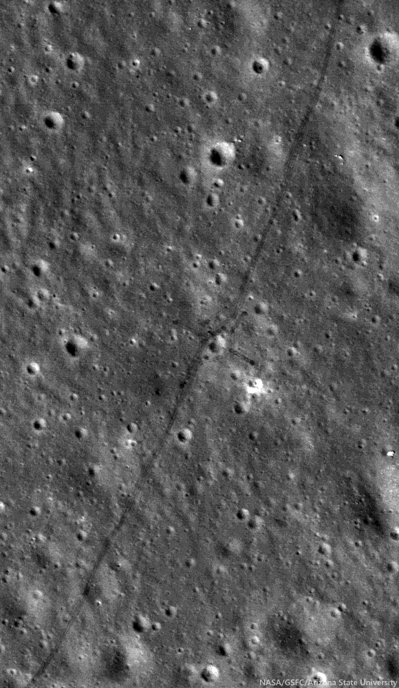
Tracks made by Lunokhod 2 in 1976 as the Soviets tested for variations in the local magnetic field while traversing around a small crater (25.764°N, 30.474°E) inside le Monnier crater, on the eastern edge of Mare Serenitatis. From LROC NAC observation M122007650R, LRO orbit 3114, February 28, 2010; 36.59° incidence angle, resolution 50 cm from 43.89 km [NASA/ GSFC/ Arizona State University].
Mark Robinson
Principal Investigator
Lunar Reconnaissance Orbiter Camera
Arizona State University

On 15 January 1973, just one month after the successful Apollo 17 mission culminated the US Project Apollo, the Soviet Luna 21 spacecraft landed softly just 170 km north of the Apollo 17 site on the eastern margin of Mare Serenitatis.

A day later on 16 January the rover Lunokhod 2 disembarked and, on 18 January, with a full battery charge it circumnavigated and imaged its faithful lander and began its record-setting journey across the lunar landscape.

The eight-wheeled rover was operated by controllers in Simferopol, Crimea, mainly using a mast-mounted TV camera and ‘joystick’ controls and roved the lunar surface for five Earth months, surviving four bitterly cold lunar nights (as low as -150 °C (-240 °F)) and racking up about 39 km (~24.4 miles) of traverse distance.

The original reported distance was 37 km, which made Lunokhod 2 the planetary rover traverse distance record holder! Along its traverse, Lunokhod 2 carried out a series of scientific experiments that were not well publicized in the United States.  Today’s Featured Image shows a cross-like pattern of rover tracks made as Lunokhod 2 explored a small crater, making various scientific measurements.

A typical Lunokhod operations crew included a commander, a navigator, a driver, an engineer, a radio/antenna operator, and one man in reserve.

Panorama taken by Lunokhod 2 at the crater shown in LROC NAC observation M122007650R (cropped from L2_D03_S03_P05m). The main experiments at this location were to test for changes in the local magnetic field due to the crater and characteristics of the regolith [Courtesy of Roskosmos and Russian Academy of Sciences].
Tracing the tracks in LROC NAC images, with new accurate geodetic controls that incorporate the latest topographic information from LROC and LOLA, the length of the Lunokhod 2 traverse is now accurately determined and is greater than the originally estimated 37 km.  In fact, the intrepid Lunokhod 2 traversed approximately 39 km!  The new traverse measurements were carried out by scientists at Moscow State University, and then again by a team at Washington University in St. Louis. The distance measurements follow the complete route shown by the tracks: including a “tripled” segment about 2 km in length, several long, linear magnetometer traverses, and several impact crater crossing maneuvers.

Lunokhod 2 traverse overview, low resolution version of six NAC image mosaic (original 1.3 m pixel scale), Sun from the west (see also Abdrakhimov, 42nd LPSC 2011) [NASA/GSFC/Arizona State University].
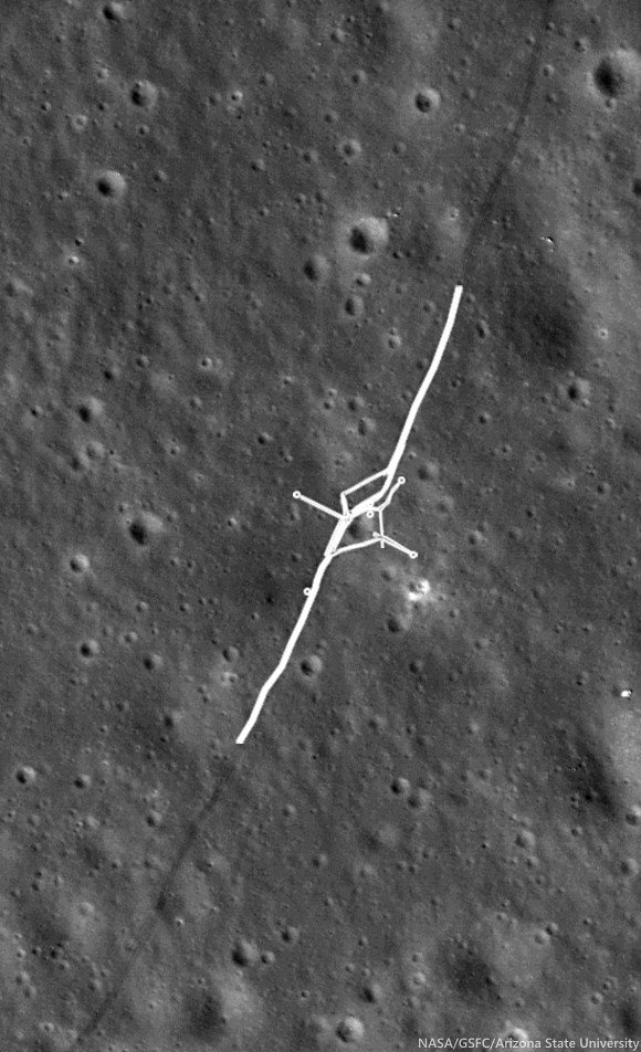
LROC NAC M122007650R, with portion of Lunokhod 2 rover tracks highlighted, where instruments gathered magnetometer measurements and did a triple traverse. Small circles can also be seen where the Lunokhod turned in place to take panoramic images [NASA/GSFC/Arizona State University].
Exploring Hilly Terrain

During the Lunokhod 2 mission, as the deputy leader of the Scientific Team and leader of the Geology Group, Dr. Alexander “Sasha” Basilevsky worked tirelessly to maximize the science return of the mission. Meeting this goal was not so easy because the Managing Group (Crew plus representatives of Lavochkin Association, which built the Lunokhods) was mostly thinking about demonstrating the roving and control capability of Lunokhod 2, and establishing a new distance record. Dr. Basilevsky recounts,
“So when moving south from the landing point, we crossed the mare area and reached a hilly terrain (low "highland" terrain).  I was planning to study it and then to go north and then east towards a graben later called Fossa Recta. But the managing team did not like long sessions of TV stereo-imaging and other measurements, and they sent Lunokhod back to the north despite my protests.
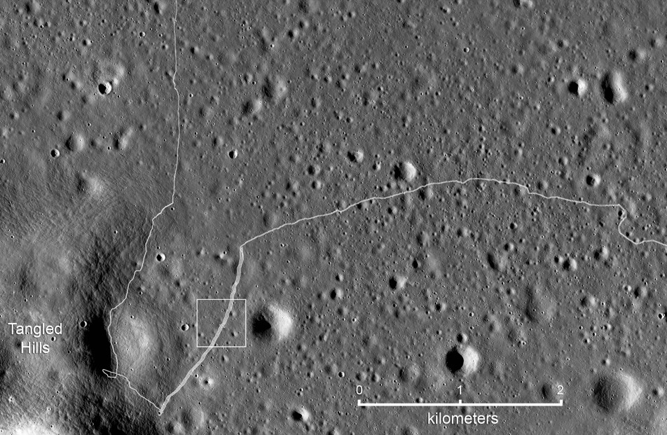
Detail map of the SW portion of the Lunokhod 2 traverse. White box indicates the field of view shown at high-resolution in the LROC Featured Image released May 2014 [NASA/GSFC/Arizona State University].
“So I called to Moscow to the head of my laboratory, Professor Cyrill Florensky, he called to Vice President of Academy of Sciences Academician Alexander Vinogradov, and Vinogradov called Sergei Kryukov, the Lavochkin Association director, and explained that the hilly terrain had to be studied. Kryukov agreed and called to the Lunokhod Control Center in Crimea where we were and said, ‘please, follow the suggestion of that guy Basilevsky.’
“Meanwhile Lunokhod 2 proceeded quite a long way. After the Kryukov call worked, the crew just turned the vehicle back and then drove along the track. That was safe and they could be fast. When Lunokhod 2 came back to the hilly terrain station we made several panoramas, and then drove back to north along the double track and again could be fast.
“So the result was good for both sides of the [issue]: For science: we studied [the hilly] terrain, and for the Managing Group: Lunokhod made a lot of meters.”
At the conclusion of the ‘tripled’ traverse segment, Lunokhod 2 had racked up about 17 km of odometry. Controllers then began the long eastward drive to Fossa Recta (‘Straight Rille’), crossing Fossa Inconspicua (‘Unnoticed Rille’) along the way. Magnetometer experiments were done along the tripled traverse to test for effects related to the mare-highland boundary, and later, on the east and west sides of Fossa Recta (see below). Other observations and measurements included soil compositional analyses using an X-ray fluorescence spectrometer, soil mechanics experiments using a penetrometer, solar X-ray monitoring, a photodetector to detect UV light sources and the level of Earth-glow on the night-time Moon, laser ranging, 86 panorama photos, and some 80,000 TV pictures. The laser ranging retroreflector, a French instrument, is still in use today.

Fossa Recta Exploration

On its fourth lunar day of roving, Lunokhod 2 explored a linear depression (graben or rille), Fossa Recta. After approaching the depression, the Lunokhod was driven along a path leading away from its edge to measure any changes in the local magnetic field associated with the depression, and then back along the same path to the edge again.  By reversing its direction and retracing its path, the effect of the Lunokhod, itself, on the magnetic signal could be determined and subtracted from the signal. A portion of the panorama taken by Lunokhod 2 when it approached the graben of Fossa Recta is shown below.
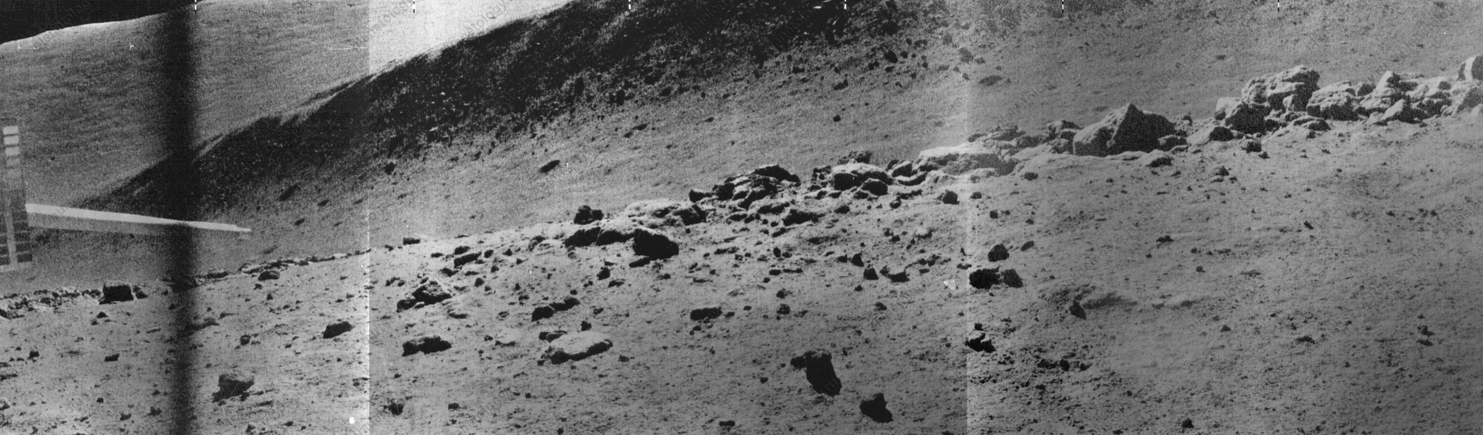
Part of the Panorama (L2_D04_S11_P09m) showing a portion of the Fossa Recta, stretching from north (left) to south (right) and a boulder field in the foreground. The sharp object on the left side of the panorama is the soil penetrometer [Courtesy of Roskosmos and Russian Academy of Sciences].
When the panorama was taken, Lunokhod 2 was on the western edge of Fossa Recta, at the position shown above, and boulders on the very edge of the depression are readily seen. The boulders were described in a paper by Basilevsky, Florensky, and Ronca (1977) in a scientific journal, The Moon, Vol. 17, and interpreted as boulders derived from lava bedrock at the edge of a long linear depression.  The characteristics observed at the edge of the fossa are similar to those seen by Apollo 15 astronauts Dave Scott and Jim Irwin at Hadley Rille. After exploring Fossa Recta Lunokhod 2 was nowhere near done!

Related Posts
Tuesday, December 31, 2013

Chang'e-3 lander and Yutu rover from LRO

LROC view of Chang'e 3
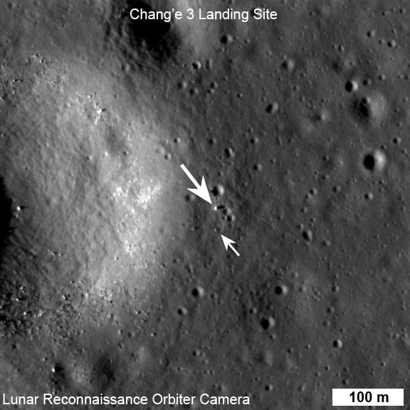
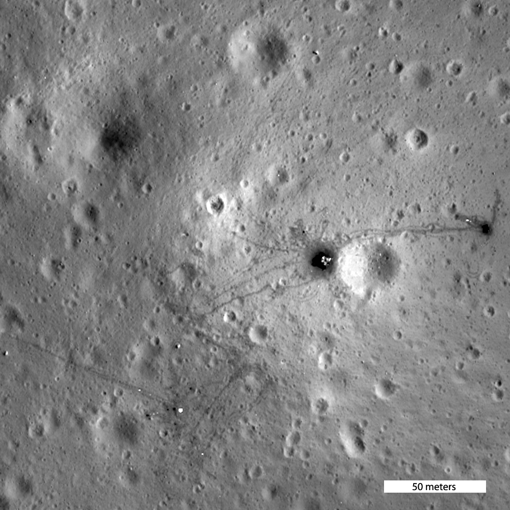
LROC Narrow Angle Camera (NAC) view of the Chang'e 3 lander and Yutu (Jade Rabbit) rover just before local sunset on their first lunar day of exploring Mare Imbrium. LROC NAC M1142582775R, image field of view 576 meters [NASA/GSFC/Arizona State University].
Mark Robinson
Principal Investigator
Lunar Reconnaissance Orbiter Camera
Arizona State University

Chang'e 3 landed on Mare Imbrium (Sea of Rains) just east of a 450 m diameter impact crater on 14 December 2013. Soon after landing, a small rover named Yutu (Jade Rabbit) was deployed and took its first tentative drive onto the airless regolith. At the time of the landing LRO's orbit was far from the landing site so images of the landing were not possible. Ten days later on 24 December, LRO approached the landing site, and LROC was able to acquire a series of six LROC Narrow Angle Camera (NAC) image pairs during the next 36 hours (19 orbits).

YuTu Rover (58762-717x940)
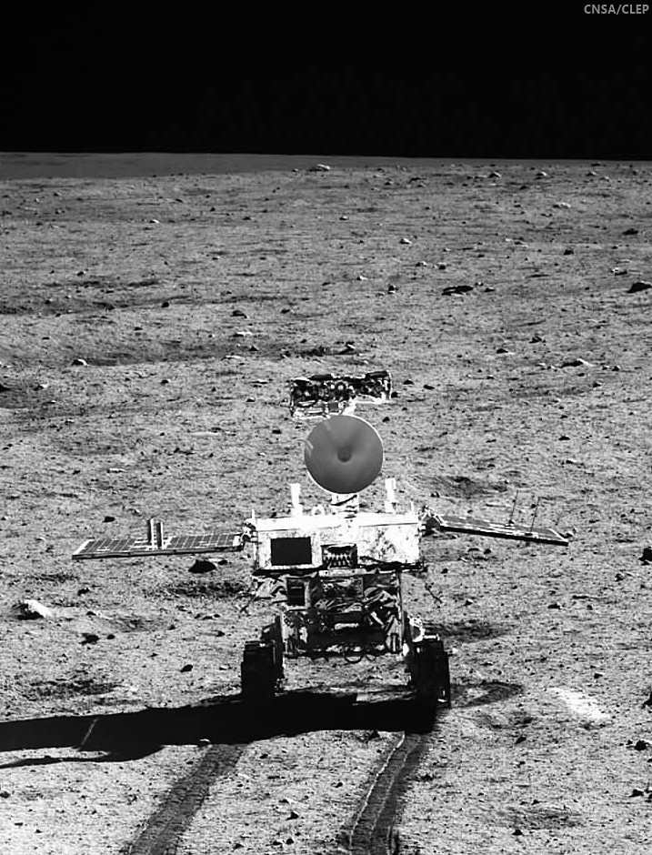
Yutu in a monochrome still captured from the Chang'e-3 lander, already slumbering in preparation for the bristling cold 14 day lunar night [CNSA/CLEP].
The highest resolution image was possible when LRO was nearly overhead on 25 December 03:52:49 UT. At this time LRO was at an altitude of ~150 km above the site, and the pixel size was 150 cm.

LROC NAC before and after images of the Chang'e 3 landing site [NASA/GSFC/Arizona State University].
The rover is only about 150 cm wide, yet it shows up in the NAC images for two reasons: the solar panels are very effective at reflecting light so the rover shows up as two bright pixels, and the Sun is setting thus the rover casts a distinct shadow (as does the lander). Since the rover is close to the size of a pixel, how can we be sure we are seeing the rover and not a comparably sized boulder? Fortuitously, the NAC acquired a "before" image (M1127248516R) of the landing site, with nearly identical lighting, on 30 June 2013. By comparing the before and after landing site images, the LROC team confirmed the position of the lander and rover, and derived accurate map coordinates for the lander (44.1214°N, 340.4884°E, -2640 meters elevation).

Panorama to LROC Narrow Angle CameraNAC
Chang'e 3 lander panorama [Images from CNSA; compiled by Di Lorenzo and Kremer] showing Yutu shortly after it drove down the ramp to the surface. Yellow lines connect craters seen in the panorama and the LROC image (taken at a later date after the rover had moved), red lines indicate approximate field of view of the panorama.
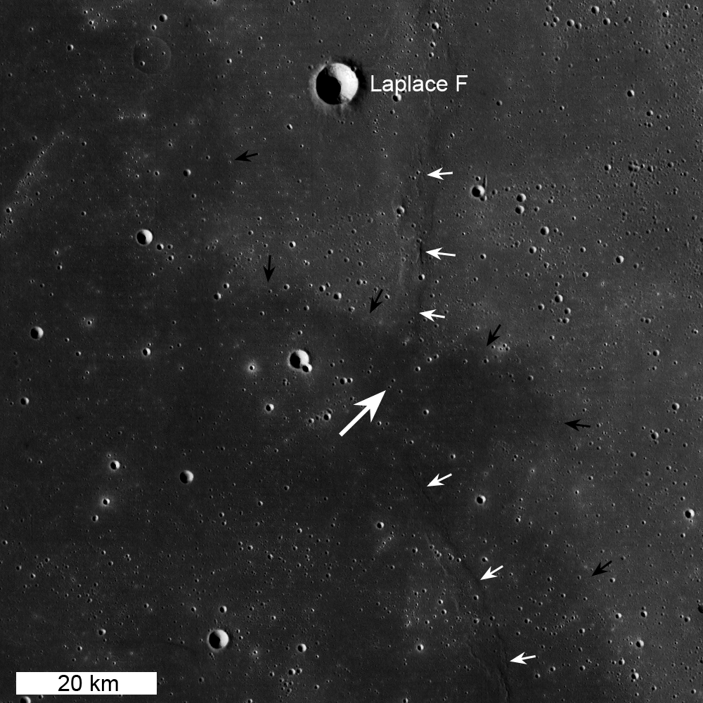
The lander set down about 60 meters east of the rim of a 450 meter diameter impact crater (40 meters deep) on a thick deposit of volcanic materials. A large scale wrinkle ridge (~100 km long, 10 km wide) cuts across the area and was formed as tectonic stress caused the volcanic layers to buckle and break along faults. Wrinkle ridges are common on the Moon, Mercury and Mars.

change3_wac_morph_and_noslew_1000
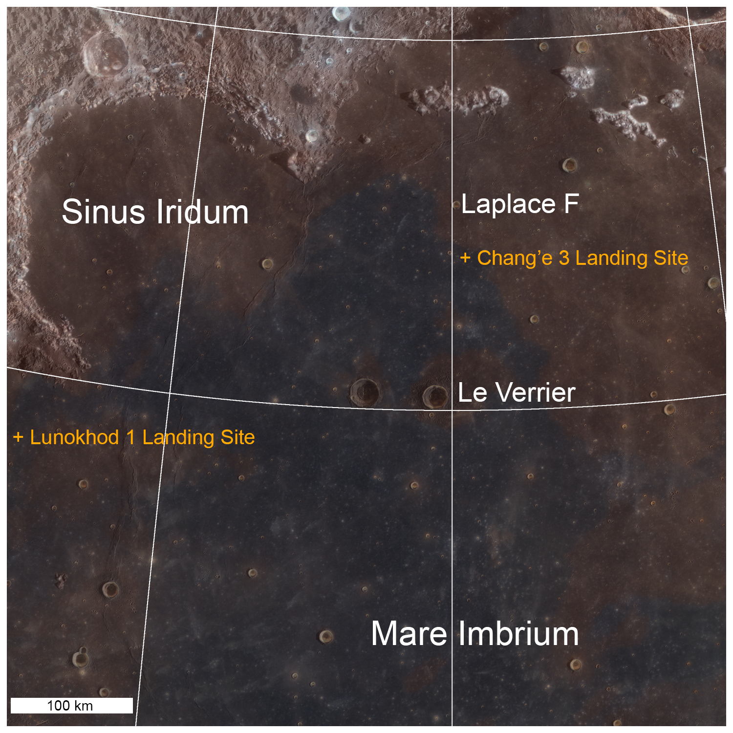
LROC WAC context mosaic for the Chang'e 3 landing site (large white arrow); small white arrows indicate wrinkle ridge and small black arrows delimit boundary between "red" mare (northeast) and "blue" mare (southwest), image is 100 km wide [NASA/GSFC/Arizona State University].
M177x3C_604nm-anot-58x128-1337x2950
Another LROC Wide Angle Camera mosaic, captured at high incidence, show the extent of the wrinkle ridge in northwest Mare Imbrium. Area swept up during three sequential orbital passes in 2011. See the full-size mosaic HERE [NASA/GSFC/Arizona State University]/
Lunar mare basalts are divided into two main spectral (color) types: "red" and "blue" (blue is perhaps a misnomer, think "less red"). Basalts on the Moon (same on Earth) are composed mainly of two minerals, pyroxene and plagioclase, though olivine and ilmenite can sometimes occur in significant amounts. The presence of ilmenite (FeTiO3) results in lower reflectance and a "less-red" color - thus the blue basalts. The landing site is on a blue mare (higher titanium) thought to be about 3.0 billion years old. The boundary (black arrows in above WAC mosaic) with an older (3.5 billion years) red mare is only 10 km to the north.

WAC Color Chang'e 3
LROC WAC color (689 nm, 415 nm, 321 nm) overlain on WAC sunset black and white image. Note the proximity of the landing site to a contact between red and blue maria [NASA/GSFC/Arizona State University].
A large area LROC WAC topography map of the Imbrium basin and surrounds is available HERE.

Related LROC Featured Images:
Safe on the Surface of the Moon!
A Great Place to Rove!
LROC Coordinates of Robotic Spacecraft - 2013 Update

Chang'e 3: NAC before and after images
LROC NAC observations before and after, animated above [NASA/GSFC/Arizona State University].

Tuesday, November 19, 2013

Lunar Laser Ranging: The Millimeter Challenge

Lunar Laser Range Reflector arrays
The five Lunar Laser Range Reflector (LLR or LLRR) arrays deployed on the lunar surface, one each at the landing sites of Apollo 11, 14 and 15, and also to the Soviet rovers Lunokhod 1 and 2. The sublime accuracy of the decades-long measurements are priceless to astrophysics. Nearside view from "Synthetic View of the Moon," LROC Featured Image released October 15, 2013 [NASA/GSFC/Arizona State University].
T. W. Murphy, Jr.
Center for Astrophysics and Space Sciences
University of California

Lunar laser ranging has provided many of the best tests of gravitation since the first Apollo astronauts landed on the Moon. The march to higher precision continues to this day, now entering the millimeter regime and promising continued improvement in scientific results. This review introduces key aspects of the technique, details the motivations, observables, and results for a variety of science objectives, summarizes the current state of the art, highlights new developments in the field, describes the modeling challenges and looks to the future of the enterprise.

Since 1969, lunar laser ranging (LLR) has provided high-precision measurements of the Earth-Moon distance, contributing to the foundations of our knowledge in gravitation and planetary physics. While being the most evident force of nature, gravity is in fact the weakest of the fundamental forces, and consequently the most poorly tested by modern experiments. Einstein's general relativity, currently our best description of gravity, is fundamentally incompatible with quantum mechanics and is likely to be replaced by a more complete theory in the future. A modified theory would, for example, predict small deviations in the solar system that, if seen, could have profound consequences for understanding the universe as a whole.

Utilizing reflectors placed on the lunar surface by American astronauts and Soviet rovers, LLR measures the round-trip travel time of short pulses of laser light directed to one reflector at a time. By mapping the shape of the lunar orbit, LLR is able to distinguish between competing theories of gravity. Range precision has improved from a few decimeters initially to a few millimeters recently, constituting a relative precision of 10-9 through 10-11. Leveraging the raw measurement across the Earth-Sun distance provides another two orders of magnitude for gauging relativistic effects in the Earth-Moon-Sun system.

The largest of the Apollo lunar laser range reflectors (LLRR) arrays, deployed at Hadley Rille by Scott and Irwin of the Apollo 15 surface expedition in February 1971. The instrument is still a regularly acquired critical part of on-going experimental astrophysics. AS15-85-11468 [NASA/JSC].
As LLR precision has improved over time, the technique has remained at the cutting edge of tests of gravitational phenomenology and probes of the lunar interior, and has informed our knowledge of Earth orientation, precession, and coordinate systems. LLR was last reviewed in this series in 1982; this update describes the key science drivers and findings of LLR, the apparatus and technologies involved, the requisite modeling techniques, and future prospects on all fronts.

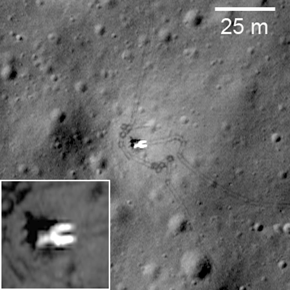
Lunokhod 1 rover in its final parking place (38.315°N, 324.992°E) on the surface of Mare Imbrium. LROC Narrow Angle Camera (NAC) observation M175502049RE, orbit 10998, November 9, 2011, resolution 33 cm per pixel. View original Featured Image released March 14, 2012 (with enlarged inset) HERE [NASA/GSFC/Arizona State University].
LLR is expected to continue on its trajectory of improvement, maintaining a leading role in contributions to science. Other recent reviews by Merkowitz (2010) and by Muller, et al. (2012) complement the present one. The Merkowitz review, like this one, stresses gravitational tests of LLR, but with greater emphasis on associated range signals. Next-generation reflector and transponder technologies are more thoroughly covered. The Muller et al. review (for which this author is a co-author) covers a more complete history of LLR, has statistics on the LLR data set, and provides greater emphasis on geophysics, selenophysics, and coordinate systems.

This review is organized as follows: Section 1 provides an overview of the subject; Section 2 reviews the science delivered by LLR, with an emphasis on gravitation; Section 3 describes current LLR capabilities; Section 4 relates recent surprises from LLR, including the finding of the lost Lunokhod 1 reflector and evidence for dust accumulation on the reflectors; Section 5 treats the modeling challenges associated with millimeter-level LLR accuracy; and Section 6 covers possible future directions for the practice of LLR.

Thursday, November 7, 2013

Ranger 7: Making an Impact on History

M153014430L-Ranger_7
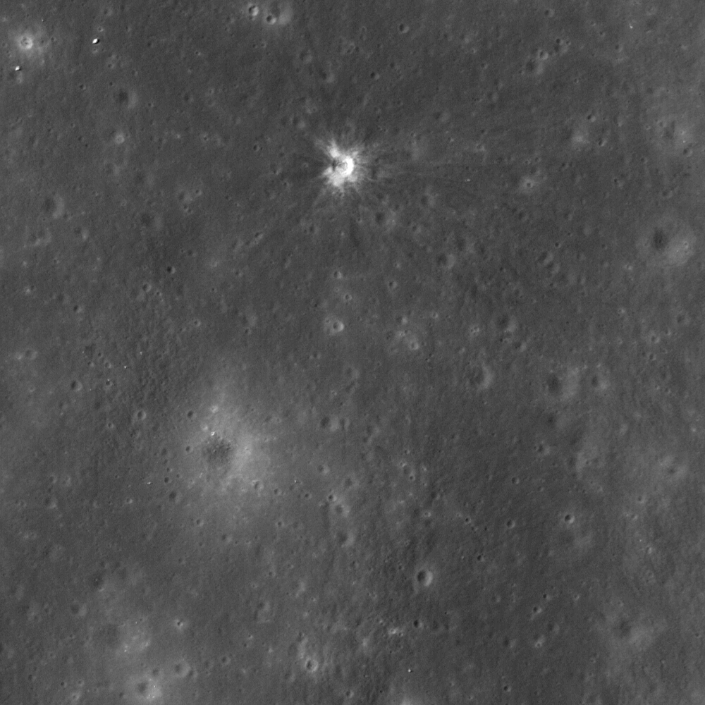
Impact site of Ranger 7, a 14 meter-wide crater near the center of Mare Cognitum (10.634°S, 20.677°W). 487 meter-wide field of view from LROC Narrow Angle Camera (NAC) observation M153014430L, LRO orbit 7693, February 22, 2011; 33.97° angle of incidence, resolution 49 centimeters per pixel from 42.69 km [NASA/GSFC/Arizona State University].
J. Stopar
LROC News System

On 31 July 1964, Ranger 7 returned the first high resolution images of the Moon specifically collected in preparation for the Apollo lunar landings (1969-1972); the first definitive success of the Ranger program.

Rangers 1 and 2 were test missions in Earth orbit (1961), and Rangers 3 through 6 (1962-1964) were launched on an impact trajectory to the lunar surface. Rangers 3 through 6 were meant to return images of the lunar surface on approach to the Moon and up until the instant of impact, resulting in a suite of images with progressively higher and higher resolution of the lunar surface. However, only Rangers 4 and 6 met their intended target.

Despite this accomplishment, both the Rangers 4 and 6 spacecraft, due to technical problems, failed to collect or return any images leading up to their final destination. Finally, Ranger 7 (1964) was successful! It returned images of an extensively cratered terrain in Mare Cognitum, and this pioneering spacecraft paved the way to our current understanding of the composition and physical properties of the lunar surface. As a result of the images returned by Rangers 7 through 9 (1964-1965), scientists and engineers generally agreed that the lunar surface was safe for the then-upcoming Apollo missions.

RANGER replica
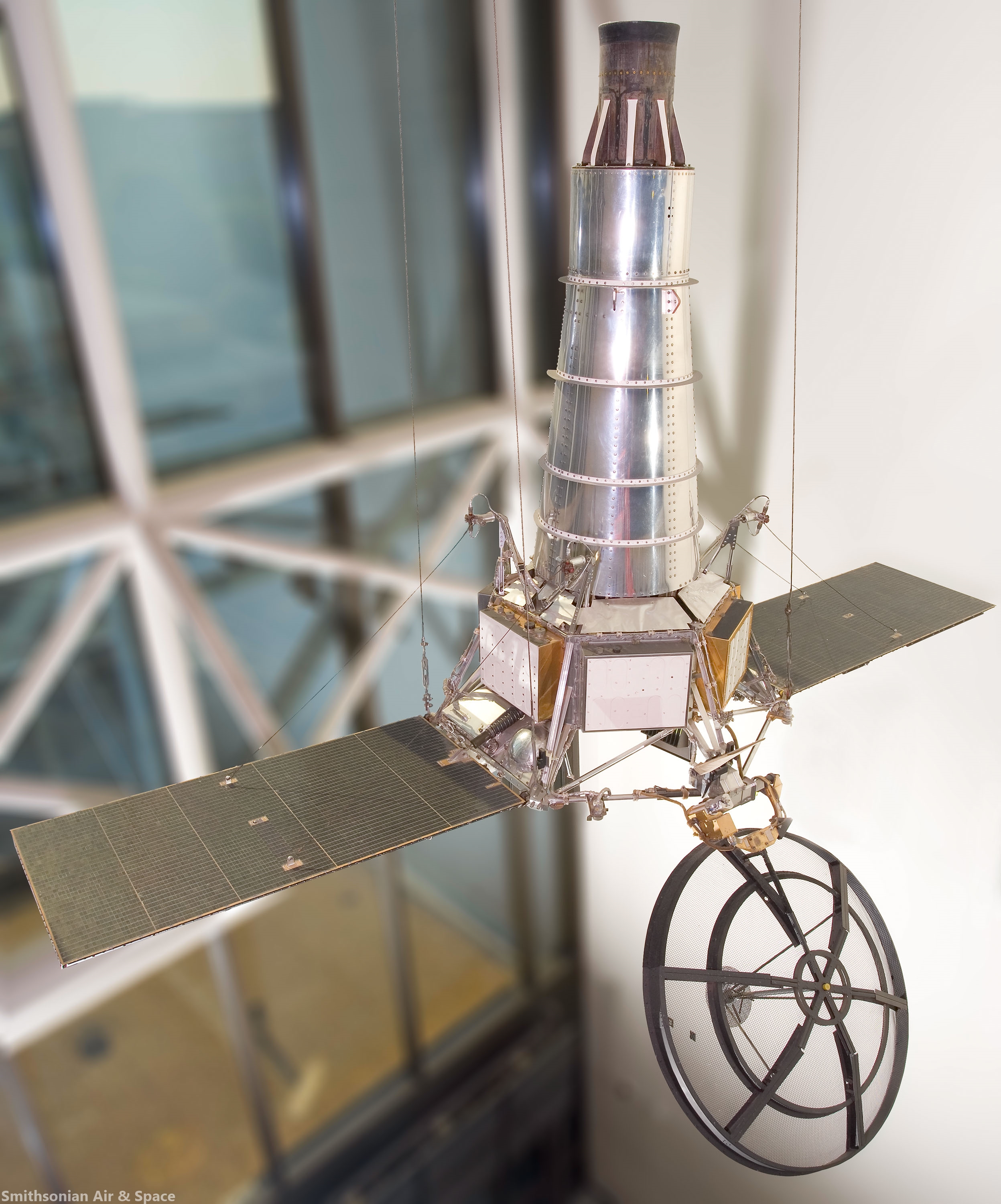
Replica of Ranger Block III (Rangers 6-9) spacecraft on display at the Smithsonian National Air and Space Museum. The replica spacecraft made of parts from Ranger test vehicles and is about 10 meters tall and 4.5 meters wide  [Smithsonian Air & Space].
Ranger 7 transmitted an image of its impact point in Mare Cognitum seconds before impacting at roughly 2.7 km/s. In 1972, the Apollo 16 orbital panoramic camera captured frame AS16-P-5430 that contained a view of the recently formed Ranger 7 impact crater. The figures below show a portion of this panoramic frame. The full resolution AS16-P-5430 frame can be viewed at the Apollo Image Archive. This panoramic frame allowed observation of Mare Cognitum several years after the Ranger 7 impact, revealing a new crater nearly 14 m in diameter at the exact location of the known Ranger 7 impact! This crater, along with impact craters formed by other early lunar spacecraft such as Ranger 9, are some of the earliest examples of confirmed change detections (the formation of a new feature) on the lunar surface. The details of the Ranger 7 and 9 impact craters were described by Moore in 1972 following analysis of images returned from Apollo 16.

Ranger 7 impact crater as seen in Apollo 16 panoramic camera frame AS16-P-5430 [NASA/JSC/Arizona State University].
Full width (downsampled) Apollo 16 panoramic camera frame AS16-P-5430. Yellow box shows location of Ranger 7 impact crater. North is to the right [NASA/JSC/Arizona State University].
The LROC NAC has now imaged the Ranger 7, 8, and 9 impact craters multiple times at various lighting conditions. These images can be explored in detail on our newly updated Featured Sites page.

Low sun images (below) display the degree to which the mare has been extensively cratered in this part of the Moon. Hartmann (1967) originally interpreted this dense cratering to imply that the mare in this area are more than several billion years old. On the other hand, high sun images (like today's Featured Image at the top of the page) bring out the high reflectance ejecta rays that extend many crater diameters from the impact. The darker rays to the west of the crater are downrange from the known impact direction (roughly 115° east of north). The distribution of rays and their composition provide clues about direction of impact, composition of the subsurface, as well as impactor properties.

Ranger 7 impact crater
The 14 meter-wide impact crater as seen through the high-resolution LRO (LROC) Narrow Angle Camera (NAC) under high-angle (sunset) illumination, the long shadows emphasizing topography over reflectance [NASA/GSFC/Arizona State University].
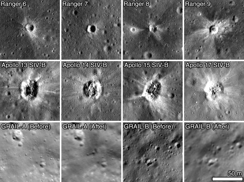
The Ranger spacecraft all formed small (approximately 15 meters in diameter), roughly circular impact craters. But depending on the impact shape, mass distribution, velocity, and angle of impact, the resulting crater size and morphology vary. For example, the Apollo Saturn V launch stages (S-IVBs) that were intentionally impacted into the lunar surface between 1970 and 1972 were more massive and cylindrical in shape than the Ranger spacecraft (but impacted at a similar velocity), resulting in larger and elongate craters. A new collection of LROC NAC images of the Apollo S-IVB impactors can also be explored on our updated Featured Sites page. A full list of known coordinates of robotic spacecraft, including those that impacted the lunar surface, was also recently updated by the LROC team and can be downloaded and viewed as a map.

Explore the full LROC NAC frame of the Ranger 7 impact site, HERE.

Related Posts:
LROC Coordinates of Robotic Spacecraft 2013 Update (September 25, 2013)
Surveyor Crater, Before and After (July 9, 2013)
Graves of the GRAIL twins (March 19, 2013)
48 years of memories of Alphonsus and Ranger 9 (January 24, 2013)
Ranger 8 impact on digitized LOIRP image (July 31, 2012)
The discarded extension of the Ranger program (April 30, 2012)
"Boy, that sure looks like Luna 9!" (December 3, 2011)
Apollo 13 S-IVB Impact in Apollo seismic recordings (March 22, 2010)
The LCROSS 'Smoking Gun' (November 13, 2009)
LCROSS confirms water on the Moon (November 13, 2009)
When bombing the Moon was a good idea (October 21, 2009)
Apollo 14 S-IVB Impact Crater (October 8, 2009)

Wednesday, September 25, 2013

LROC updates image tally of human artifacts on the Moon

Luna 17, the spacecraft that carried the Lunokhod-1 rover to the surface of the Moon; debarking ramps for the rover tracks around the lander are visible, extending southeast, to the right. LROC Narrow Angle Camera (NAC) frame M175502049RE, LRO orbit 10998, November 9, 2011; angle of incidence 57.78° at 43 cm per pixel resolution from 30.66 km over 38.23°N, 325.01°E. View the original contextual image with an enlarged inset HERE [NASA/GSFC/Arizona State University].
Samuel Lawrence
LROC News System

Repeat imaging of anthropogenic targets on the Moon remains an LROC priority as the LRO Extended Science Mission continues. These continuing observations of historic hardware and impact craters are not just interesting from a historical standpoint - each image adds to our knowledge of lunar science and engineering, particularly cartography, geology, and photometry.

Making sure that the lunar cartographic network is accurate is a critical component for planning future lunar missions for both human and robotic exploration of the Moon. The historic spacecraft serve as benchmarks (especially the laser retroreflectors). When new images arrive and final ephemeris is in hand we can check if the hardware has moved - well, actually we see the level of uncertainty in computing latitude/longitude coordinates (currently about ±15 meters).

View of the Luna 17 lander from the Lunokhod-1rover (the vehicle descended from its position atop the lander from the opposite side). A wide variety of images, including many other firsts from the Soviet Union's lunar exploration program  of the Cold War era can be viewed HERE.
Currently the United States has no near-term plans to land humans or robotic spacecraft on the Moon, however China is scheduled to launch the Chang'e 3 mission in December. If we are lucky, the LROC team might have a before picture to compare to any after pictures of the Chang'e 3 landing site (the exact planned landing coordinates have not yet been released). Currently all LROC NAC investigations must rely solely on "after" images of landing sites. Obtaining a before and after set of images of the Chang'e 3 will facilitate a much better understanding of the delicate processes involved in regolith redistribution due to lander rocket plumes.

When a spacecraft lands on the Moon in a powered descent, exhaust gases from the descent engine disrupt the surface resulting in visible changes around the landed vehicle. These changes can be better understood with photometric studies using using LROC NAC images taken with different illumination geometries. Close to (or right under) the lander the soil is most disrupted, leading to reduced reflectance. Interestingly a zone of increased reflectance surrounds the lander. This "blast zone" ranges from a few meters for the Surveyor spacecraft, to a few tens of meters for Luna, and a few hundred meters for Apollo.

The Apollo 15 landing site through shifting shadows of a simulated lunar day, courtesy of the LROC Featured Sites Index. Very little appears to have changed since the departure of Scott and Irwin nearly 600 lunar days ago [NASA/GSFC/Arizona State University].
Photometric modeling indicates possible causes for the increased reflectance zones from smoothing of the surface by the exhaust flow, the destruction of micro-scale regolith structure, and/or the redistribution of fine particles from the area beneath the lander to its surroundings. Modeling the dynamics of rocket exhaust plumes and studying the exhaust plume effects of previous landed spacecraft on the Moon are defining safe operational practices for future landing sites and outposts.

Exceptionally detailed photograph of the Ranger 9 impact on the floor of Alphonsus crater appears to include an inner disk of darker material around 10 meters across, possibly melt created by the release of kinetic energy, LROC NAC M170579736R, LRO orbit 10272, September 13, 2011; angle of incidence 16.1° at 49.6 cm per pixel resolution from 44.64 km [NASA/GSFC/Arizona State University].
Selection of spacecraft impact sites imaged from LRO using the LROC twin Narrow Angle Camera instrument, all at the same scale [NASA/GSFC/Arizona State University].
Careful retracing of the Lunokhod 2 traverse dramatically improved our understanding of the surface activities of that intrepid rover. In addition, by accurately determining the locations of the Luna 23 and Luna 24 landers, the LROC team determined not only how the Luna 23 spacecraft failed, but also that the Luna 24 sample was collected on the rim of a small impact crater, providing an explanation for the discrepancies that existed for the past three decades between samples and remote sensing of the Mare Crisium surface.

Check out a map of robotic spacecraft sites on the lunar surface, HERE.

(a) listing of coordinates (mean Earth/polar axis (ME) system) of ... Soviet and American robotic space hardware and craters produced through spacecraft impact (thus far) identified by the LROC Team can be download as an Adobe PDF file is available HERE.

ED NOTE: This is at least a partial update to "Coordinates of Robotic Spacecraft," released April 9, 2010.

To generate the list of observed latitudes and longitudes, we compiled a list of line and sample coordinates for the center of each object in each image. Each image was then initialized using the USGS Integrated Software for Imagers and Spectrometers (ISIS) software package, attaching the appropriate spacecraft position and pointing information, along with the GLD100 lunar shape model for elevation. ISIS routines were then used to compute the latitude and longitude of the spacecraft (or impact crater) in that image.

The LRO spacecraft positions on the list were provided by the latest cross-over corrected spacecraft positioning kernels provided by the LRO LOLA Team, with an orbital position uncertainty of 15 meters. Finally, temperature-corrected NAC camera kernels produced by the LROC team contributed to the high precision and accuracy. The coordinates listed in the table are statistical median from all of the images acquired before April 28, 2013 for a particular site.

Related Posts:
Apollo 12 at 43 Years (November 20, 2012)
Taurus Littrow Oblique (September 29, 2012)
Close-up on the lonely trail of Lunokhod-2 (September 17, 2012)
America's last unmanned lunar lander (September 7, 2012)
"Houston, Tranquility Base here" (August 28, 2012)
Scooping the Soviets (August 8, 2012)
Apollo 15 departs Hadley Rille Delta - 41 years ago (August 2, 2012)
Tranquility Base at high-resolution before Apollo 11 (August 2, 2012)
Ranger 8 impact on restored Lunar Orbiter LOIRP photograph (July 31, 2012)
"O! Say can you see, by the dawn's early light" (July 27, 2012)
New tool for exploring LROC images and Apollo landing observations (July 19, 2012)
Craters bear Lunokhod-1 officially named (July 3, 2012)
Astronaut's eye view of the Apollo 16 landing site (June 19, 2012)
Who discovered water on the Moon (June 1, 2012)
Will China deploy the first lunar rover since 1976? (April 30, 2012)
The discarded extension of the Ranger program, David S.F. Portree (April 30, 2012)
Orion, up close (April 24, 2012)
Forty years ago, 'a big ol' Navy salute' (April 21, 2012)
Forty years ago-Apollo 16 (April 21, 2012)
The Last Sampler: Failure, then Success (March 17, 2012)
Lunokhod-1 revisited, too (March 15, 2012)
Lunokhod-2 revisited (March 13, 2012)
Pinpoint Landing on the Moon - Apollo 12 (March 12, 2012)
How Young is Young? - Apollo 16 (March 9, 2012)
LROC's closest look yet at Tranquility Base (March 8, 2012)
Apollo 12 and its pinpoint landing in the Moon (March 7, 2012)
Follow the tracks - Apollo 15 (March 6, 2012)

From the second of two sequential, exceptionally low periapsis orbital passes, allowing the LROC team at Arizona State University to capture breathtaking views of the Apollo 16 landing site in the nearside Southern Highlands, LRO orbit 10950, November 6, 2011; LROC NAC M175179080, field of view 145 meters, released on the 40th anniversary of the lift-off from the Moon of the Young and Duke expedition, April 22, 2012 [NASA/GSFC/Arizona State University]

Just another crater? (December 13, 2011)
"Boy, that sure looks like Luna 9!" (December 3, 2011)
Cernan says China will be first back to the Moon (November 8, 2011)
Hadley Rille and the Mountains of the Moon (November 8, 2011)
The First Race to the Moon, David S.F. Portree (September 27, 2011)
On the run! - Apollo 14 (September 8, 2011)
New Views of Apollo 12 (September 8, 2011)
Apollo 14 at 25 cm per pixel (September 8, 2011)
Skimming the Moon (September 8, 2011)
LRO Briefing: Latest Close-Ups of Apollo Sites (September 6, 2011)
Low altitude views of Apollo released (September 3, 2011)
First Low Altitude Apollo 12 NAC Image (August 11, 2011)
Crash or Coincidence (July 22, 2011)
Surveyor 7 (February 12, 2011)
New View of Apollo 14 (February 4, 2011)

Surveyor 7: Our Fragile Lunar LDEF (October 27, 2010)
LRO analysis of LCROSS data proves essential (October 21, 2010)
LRO transitions from exploration to science (September 16, 2010)
Apollo 16, Footsteps Under High Sun (July 11, 2010)
Too brief an expedition to a lobate scarp (August 24, 2010)
Re-acquisition: Lunokhod-1 (April 27, 2010)
Apollo 16: 38 years on (April 21, 2010)
Retracing the steps of Apollo 15: Constellation ROI (April 17, 2010)
Value-added LROC (April 16, 2010)
A fundamental point on the Moon (April 13, 2010)
The part of Apollo 13 that made it to the Moon (April 12, 2010)
Coordinates of Robotic Spacecraft (April 9, 2010)
Ranger 9 (April 4, 2010)
Absentee ownership of Lunokhod-2 (April 1, 2010)
LOLA's Tycho and the Apollo era (March 28, 2010)
The first successful robotic sampler, Luna 16 (March 26, 2010)
Apollo 13 SIVB impact (March 23, 2010)
Surveyor 5: A Hole-in-One (March 21, 2010)
Surveyor 6 on the plains of Sinus Medii (March 21, 2010)
Luna 21 Lander (March 19, 2010)
Foot fall around Orion in the mid-day glare (March 19, 2010)
Lunokhod-1 and Lunokhod-2 (March 17, 2010)
The Soviet lunar sampling missions (March 16, 2010)
Alan Bean shares Apollo 12 with community college students in Iowa (March 9, 2010)

The largest of three Apollo lunar laser range reflectors (LLRR), deployed at Hadley Rille by Scott and Irwin of Apollo 15 in February 1971. The instrument is still an active, critical component of on-going experimental science, part of the effort to further constrain the measured distance to the Moon (to within 3 mm) in part determine "locality," if any, of the laws cosmological physics. AS15-85-11468 [NASA/JSC].
Triumph (and disappointment) of Apollo 12 (November 19, 2009)
High Noon over Apollo 11 on YouTube (November 14, 2009)
Midday on Oceanus Procellarum: Apollo 12 (November 5, 2009)
Apollo 12 Second Look: Midday on the Ocean of Storms (November 4, 2009)
Apollo 17 from 50 kilometers (October 28, 2009)
When bombing the Moon was a good idea (October 21, 2009)
Apollo 14 SIVB impact (October 8, 2009)
Lonely Sentinel Abides (October 1, 2009)
Surveyor 1: America's first soft lunar landing (September 30, 2009)
Tranquility Base: a better, second look (September 29, 2009)
Shadow on the Moon (September 24, 2009)
LROC zooms in on Apollo 12 and Surveyor 3 (September 4, 2009)
First Look: Apollo 12 and Surveyor 3 (September 3, 2009)
Lasting boot prints from 1971 (August 21, 2009)
Trail of Discovery at Fra Mauro (August 19, 2009)
The continued importance of lunar laser ranging (August 3, 2009)
Rediscovering Tranquility Base (July 19, 2009)
Five Apollo landing sites photographed (July 17, 2009)
Lunar Orbiter III-154-H2 (LOIRP) (June 16, 2009)
LOIRP recovers early image of Ranger 8 impact (June 9, 2009)
Kaguya to impact June 10 (May 21, 2009)
Chang'e-1 controlled impact in Mare Fecunditatis (March 1, 2009)
More astounding detail (Surveyor 1) from LOIRP (February 26, 2009)
Anniversary of Ranger 8 (February 20, 2009)
Surveyor proved the Moon safe for man (January 4, 2009)

Chandrayaan-1 Moon Impact Probe shoots Shackleton (November 15, 2008)
Tranquility Base from Kaguya (SELENE-1) (March 29, 2008)

Tuesday, March 19, 2013

Graves of the GRAIL twins

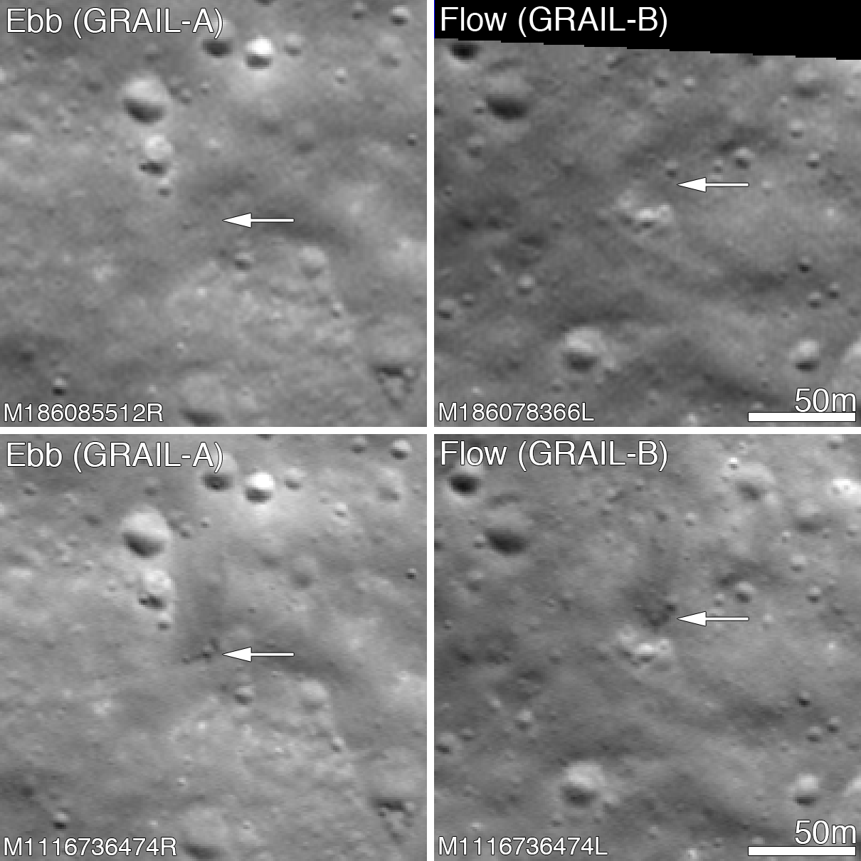
Before and after the GRAIL twins impacts on the Moon December 17, 2012. The LROC Narrow Angle Camera (NAC) directors were able to resolve the impact sites on February 28, 2013, revealing both to be about 5 meters in diameter. Upper panels show the area before the impact; lower panels after the impact. Arrows point to crater locations. LROC NAC observations M186085512R, M186078336L, M1116736474R and M1116736474L. Full size Featured Image HERE  [NASA/GSFC/Arizona State University].
Jeffrey Plescia
LROC News System

The Gravity Recovery and Interior Laboratory (GRAIL) mission ended on 17 December 2012 at 14:28 PST (-8 hrs. relative to Universal Time) when the two spacecraft GRAIL A (Ebb) and GRAIL B (Flow) impacted the Moon.

Both impact sites lie on the southern slope of an unnamed massif (mountain) that lies south of the crater Mouchez and northeast of the crater Philolaus.

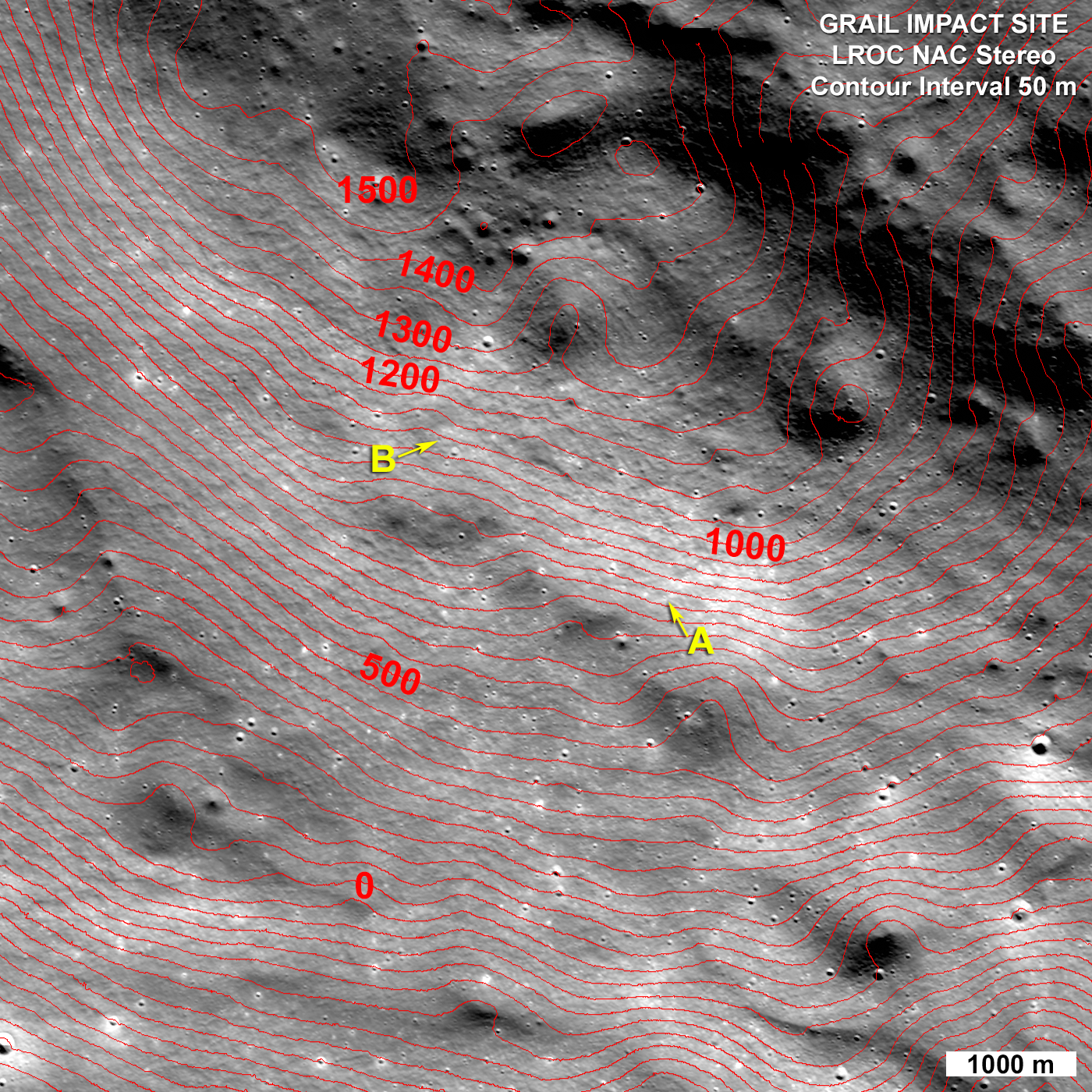
The massif stands as much as 2500 m above the surrounding plains. The impact sites are at an elevation of about 750 and 1040 meter, respectively, about 460-750 m below the summit.

Artist conception of the orbital track of the two spacecraft just before impact. Both spacecraft were tracking north as their altitude continuously decreased until they impacted the south side of the massif [NASA/JPL].
The two GRAIL spacecraft were relatively small - cubes about the size of a washing machine with a mass of about 200 kg (441 lbs) at the time of impact. When they arrived at the Moon their mass was closer to 278 kg (619 lbs), but about 78 kg (172 lbs) of that was fuel consumed during lunar operations. Both spacecraft impacted at very low angles (~2° to the horizontal) at about 1600 m/s (faster than a speeding bullet) into a fairly steep slope! LROC images reveal that both spacecraft formed craters about 5 m (15 ft) in diameter. Surprisingly, the ejecta around both craters is dark and irregularly distributed around the crater; there is little ejecta to the south - the direction from which the spacecraft were traveling.

GRAIL A site seen before and after the impact event. Crater center is located at 75.609°N, 333.407°E [NASA/GSFC/Arizona State University].
Typically ejecta from craters has a higher reflectance than the target material (think of the rays of Tycho). This normal contrast is due to the excavation of fresh (or immature) soil from beneath a more mature, weathered layer. As the lunar regolith is exposed to the vacuum of space, it suffers exposure to cosmic radiation, solar wind bombardment, and micrometeorite impacts. Slowly over time, these processes tend to darken the soil. Thus, if you dig down beneath the surface you will find higher reflectance soil.

GRAIL B site seen before and after impact event. Crater center is located at 75.651°N, 333.168°E [NASA/GSFC/Arizona State University].
So why do both GRAIL craters exhibit low reflectance rays? Perhaps we are seeing carbon from the spacecraft. The structure was made of a cyanate ester composite (carbon rich) and other materials also had carbon as primary compounds. Additionally, there was about 0.5 kg (1.1 lbs) of fuel remaining in each spacecraft. Due to the energy of impact, the carbon from these varied sources may have been released and mixed with and coated the ejecta. It takes only a very small amount of carbon to darken a material, recall in art class when you put just a few drops of black paint into a lighter color and it went all muddy. But right now we do not know for sure the cause of this interesting anomaly!

LRO Wide Angle Camera (WAC) image of the GRAIL impact area on the south side of the unnamed massif. LRO WAC M120020350 [NASA/GSFC/ASU].
On 28 February 2013 the LROC obtained a stereo pair for the impact area and from these images the LROC team produced a controlled preliminary topographic map. From the stereo model latitude, longitude and elevation were derived for each impact crater: GRAIL A 75.609°N, 333.407°E, 750 meters and for GRAIL B 75.651°N, 333.168°E, 1040 meters. The local slope of the mountain at the point of impact was 23° for GRAIL A and 19° for GRAIL B. As knowledge of the spacecraft position is refined the LROC team will update these coordinates. The two impact craters are about 2210 m apart; GRAIL B impacted about 20 seconds after GRAIL A at a site to the northwest of GRAIL A.

LROC NAC stereo derived topographic map of the GRAIL Impact area, map is 8400 meters wide, north is up [NASA/GSFC/Arizona State University].
Find the GRAIL impact craters in the full NAC image, HERE.

Related Posts:
Parting shots from Ebb MoonKAM prior to impact
Ebb and Flow Finale
Rocket Impacts Recorded by the Apollo Seismic Network
Apollo 14 S-IVB Impact Crater
Mountains of the Moon
LROC Coordinates of Robotic Spacecraft
Ejecta Sweeps the Surface

Sunday, February 3, 2013

'There's poop on the Moon'


Jason Major
Universe Today

When the Apollo boys visited the Moon back in the ’60s and ’70s they left more than just some experiments, rovers, and family portraits behind –- they also left, shall we say, a little bit of themselves on the lunar surface. It makes total sense when you think about it, but still… there’s poop on the Moon.

Read the article, HERE.

Friday, December 14, 2012

Appearance of the Moon during the GRAIL impacts

GRAIL's Final Resting Spot.  These maps of Earth's moon highlight the region where the twin spacecraft of NASA's Gravity Recovery and Interior Laboratory (GRAIL) mission will impact on Dec. 17, marking the end of its successful endeavor to map the moon's gravity. The two washing-machine-sized spacecraft, named Ebb and Flow, will impact an unnamed mountain above of 75°N. [NASA/GSFC/Arizona State University].
Pasadena (JPL) -- Twin lunar-orbiting NASA spacecraft that have allowed scientists to learn more about the internal structure and composition of the moon are being prepared for their controlled descent and impact on a mountain near the moon's north pole at about 2028 UT (5:28 p.m. U.S. EST) Monday, December 17.

Ebb and Flow, the Gravity Recovery and Interior Laboratory (GRAIL) mission probes, are being sent purposely into the lunar surface because their low orbit and low fuel levels preclude further scientific operations. The duo's successful prime and extended science missions generated the highest-resolution gravity field map of any celestial body, providing a better understanding of how Earth and other rocky planets in the solar system formed and evolved.
Perspective on the Moon at the estimated time of the GRAIL impacts, projected at 2229 UT, 17 December 2012. Waxing between New and First Quarter (4.58 days 26.8% illumination), the distance between Earth and Moon will be increasing at roughly 10 km per minute from 372,628 kilometers. In eastern North America, the Moon will have transited, riding low and west from overhead Only the best equipped observers can hope to observe the actual release of kinetic energy, an extremely fast flash, near the horn of the north-northwest limb [Virtual Moon Atlas].
"It is going to be difficult to say goodbye," said GRAIL principal investigator Maria Zuber of the Massachusetts Institute of Technology in Cambridge. "Our little robotic twins have been exemplary members of the GRAIL family, and planetary science has advanced in a major way because of their contributions."

Lunar Heritage Sites and GRAIL's Final Mile. This graphic highlights locations on the moon NASA considers "lunar heritage sites" and the path NASA's Gravity Recovery and Interior Laboratory spacecraft will take on their final flight. Navigators on the GRAIL team have designed an end of mission plan that rules out the extremely remote possibility of either of the two GRAIL spacecraft impacting near any of these historic locations. The Apollo 11, 12, 14, 16 and 17 landing sites are indicated with green circles. The Surveyor sites are indicated with yellow squares. The Soviet Union's Luna and Lunakhod landing sites are indicated with red diamonds and red squares, respectively.  The ground track for the Ebb and Flow spacecraft during their final half-orbits is shown in black. The maps are color-coded by topography. Red and white indicate the high areas. Blue and violet indicate low areas [NASA/JPL-Caltech].

The mountain where the two spacecraft will make contact is located near a crater named Goldschmidt. Both spacecraft have been flying in formation around the moon since Jan. 1, 2012. They were named by elementary school students in Bozeman, Mont., who won a contest. The first probe to reach the moon, Ebb, also will be the first to go down, at 2:28:40 p.m. PST. Flow will follow Ebb about 20 seconds later.

Both spacecraft will hit the surface at 3,760 mph (1.7 kilometers per second). No imagery of the impact is expected because the region will be in shadow at the time.

Ebb and Flow will conduct one final experiment before their mission ends. They will fire their main engines until their propellant tanks are empty to determine precisely the amount of fuel remaining in their tanks. This will help NASA engineers validate fuel consumption computer models to improve predictions of fuel needs for future missions.

"Our lunar twins may be in the twilight of their operational lives, but one thing is for sure, they are going down swinging," said GRAIL project manager David Lehman of NASA's Jet Propulsion Laboratory in Pasadena, Calif. "Even during the last half of their last orbit, we are going to do an engineering experiment that could help future missions operate more efficiently."

Because the exact amount of fuel remaining aboard each spacecraft is unknown, mission navigators and engineers designed the depletion burn to allow the probes to descend gradually for several hours and skim the surface of the moon until the elevated terrain of the target mountain gets in their way.

Ebb and Flow's Final Moments. These side-by-side, 3-D comparisons depict the unnamed lunar mountain targeted by the NASA's Gravity Recovery and Interior Laboratory (GRAIL) mission for controlled impact of the Ebb and Flow spacecraft. They also include the ground tracks the spacecraft are expected to follow into the lunar terrain. These graphics were generated using data from the Lunar Orbiter Laser Altimeter instrument aboard NASA's Lunar Reconnaissance Orbiter spacecraft. On the left is the mountain with the ground track and mission termination point for the Ebb spacecraft. On the right is the mountain, ground track and mission termination point for the Flow spacecraft [NASA/JPL-Caltech/MIT/GSFC].

The burn that will change the spacecrafts' orbit and ensure the impact is scheduled to take place Friday morning, Dec. 14.

"Such a unique end-of-mission scenario requires extensive and detailed mission planning and navigation," said Lehman. "We've had our share of challenges during this mission and always come through in flying colors, but nobody I know around here has ever flown into a moon mountain before. It'll be a first for us, that's for sure."

During their prime mission, from March through May, Ebb and Flow collected data while orbiting at an average altitude of 34 miles (55 kilometers). Their altitude was lowered to 14 miles (23 kilometers) for their extended mission, which began Aug. 30 and sometimes placed them within a few miles of the moon's tallest surface features.

The published impact coordinates for the GRAIL twins has been well-surveyed by the Lunar Reconnaissance Orbiter Camera (LROC), at least nine times at high-resolution. LROC QuickMap 125 meter resolution [NASA/GSFC/Arizona State University].
JPL manages the GRAIL mission for NASA's Science Mission Directorate in Washington. The mission is part of the Discovery Program managed at NASA's Marshall Space Flight Center in Huntsville, Ala. Lockheed Martin Space Systems in Denver built the spacecraft. JPL is a division of the California Institute of Technology in Pasadena.

For more information about GRAIL, visit: http://grail.nasa.gov and http://www.nasa.gov/grail.