
 |
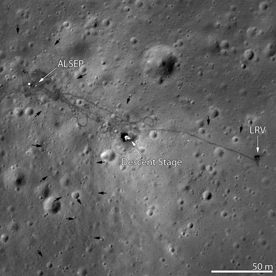
| 1971 Landing site of Apollo 15, from unusually low altitude - From only 25 kilometers (LROC observation M175252641, L and R frames). The Lunar Roving Vehicle (LRV) is parked to the far right, the Lunar Module descent stage is at center; LRV tracks are indicated with arrows. View the larger Featured Image HERE [NASA/GSFC/Arizona State University]. |

Principal Investigator
Lunar Reconnaissance Orbiter Camera
Arizona State University
Apollo 15 from unusually low altitude - Apollo 15 landing site imaged from an altitude of 25 km (M175252641L,R) allowing an even higher resolution view! The Lunar Roving Vehicle (LRV) is parked to the far right, and the Lunar Module descent stage is in the center, LRV tracks indicated with arrows [NASA/GSFC/Arizona State University].
The Apollo 15 Lunar Module (LM) Falcon set down on the Hadley plains (26.132°N, 3.634°E) a mere 2 kilometers from Hadley Rille. The goals: sample the basalts that compose the mare deposit, explore a lunar rille for the first time, and search for ancient crustal rocks. Additionally, Dave Scott and Jim Irwin deployed the third Apollo Lunar Surface Experiments Package (ALSEP) and unveiled the first Lunar Roving Vehicle (LRV). The ALSEP consisted of several experiments that were powered by a Radioisotope Thermoelectric Generator (RTG) and sent back valuable scientific data to the Earth for over six years after the astronauts left. This new LROC NAC image taken from low altitude shows the hardware and tracks in even more detail.
 |
| Mons Hadley Delta, where Hadley Rille, the mountains of the Apennine range and the Palus Putredinis mare plain all intersect near the landing site of Apollo 15 (yellow arrow), first of the Apollo "J" missions, devoted to lunar science. 30 kilometer-wide monochrome (604 nm) field of view from LROC Wide Angle Camera observation M150497920CE, LRO orbit 7313, January 24, 2011; incidence = 65.77° at 54 meters resolution from 39.36 kilometers altitude. [NASA/GSFC/Arizona State University]. |
The LRV, a lunar "dune buggy", allowed the astronauts to traverse far from the LM and explore much more local geology than the astronauts on previous missions (Apollo 11, 12, 14). Not only did the LRV allow the astronauts to move from place-to-place at a lively rate of eight to sixteen kilometers per hour (five to ten miles per hour), but the LRV also allowed brief periods of rest that in turn helped to conserve oxygen.
 |
| LROC Apollo 15 Traverse Map - Apollo 15 traverse routes sketched on subsampled NAC M106855508L/R. Red letters mark locations of images in the next figure [NASA/GSFC/Arizona State University]. |
The LRV wheels were 82 centimeters (32 inches) in diameter, and 23 centimeters (9 inches) wide. Typically LROC NAC pixels are about 50 centimeters square, so it is not always easy to pick out the LRV tracks. In previous LROC images, the LRV tracks are usually only visible near the LM where the descent engine exhaust plume disturbed the surface. The LRV wheels broke through the changed surface and thus the tracks have more contrast near the LM.
For two one-month periods last year (2011), the LRO orbit was lowered such that overflights of the Apollo sites were only 25 to 30 kilometers, rather than the usual 50 kilometers. These low passes resulted in NAC pixel scales near 25 centimeters! LRO has a ground speed of a bit over 1600 meters (5249 feet) per second, and the shortest NAC exposure time is 0.34 millseconds, so images taken from this low altitude are smeared down track a bit. However, the smear is hardly noticeable and features at the Apollo sites definitely come into sharper focus. In this new low-altitude NAC image of the LRV, tracks are visible about half of the time, usually when the tracks are at an angle to the Sun direction, rather than parallel.


It was during Apollo 15 that the rover was driven on the steepest slopes while exploring the base of a mountain named Hadley Delta (it was named Delta because of its shape, not because it was a river delta). In fact at Station 6a, as Dave Scott stepped off the rover, it started to slide downhill. He was able to grab the rover and stabilize it with no problem.
 |
| Apollo 15 LRV Station 6a - Note the slope is steep enough one of the wheels is off the ground. But how steep is steep? The boulder in the foreground is indicated with a white arrow in the next figure. AS15-86-11659 (high resolution) [Dave Scott- NASA/ALSJ/JSC]. |
How steep is steep? At the time, the astronauts estimated the slope at Station 6a between 15 and 20 degrees. With NAC stereo observations the LROC team is able to make detailed topographic maps (see below). Instead of estimating the steepness of the slope, we can now measure the slope.
 |
| Station 6a Topography Map - LROC NAC-derived topographic contours superposed on low altitude image. Black arrows indicate LRV tracks, white arrow the Station 6a boulder seen in Dave Scott's photograph above, while the black line shows the trace of the slope profile represented in plot below. (Contour interval 5 meters, elevations relative to average lunar radius) [NASA/GSFC/Arizona State University]. |
 |
| Station 6a profile - LROC NAC derived topographic profile through Station 6a (profile location shown in the above figure). The straight red line shows a consistent slope in the area of 18°, right in the middle of the range estimated by Jim Irwin while they were taking samples. |
Following the tracks of Irwin and Scott is a lot fun - join the adventure, HERE.
Previous Apollo 15 Featured Images:
Hadley Rille and the Mountains of the Moon
Retracing the Steps of Apollo 15
40th Anniversary of Apollo 15 celebrated at Kennedy Space Center
A Fundamental Point on the Moon
Kaguya captures Hadley Rille, Apollo 15
Water found in Apollo samples
Apollo metric camera digital elevation model completed
Long-term degradation of optics on the Moon
No comments:
Post a Comment