Showing posts with label Grail. Show all posts

Tuesday, July 8, 2014

A rille to rover over near Rimae Hevelius

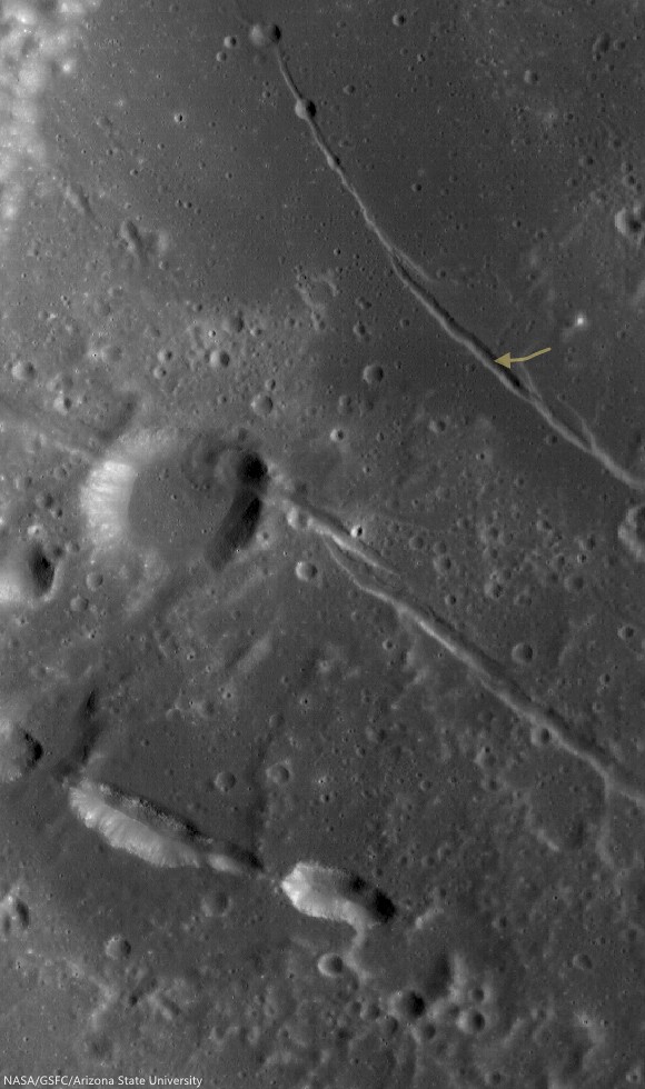
A rille found on the southwestern edge of Oceanus Procellarum, most likely formed from stress added to the surface as mare deposits were emplaced and cooled.  1200 meter-wide field of view from LROC NAC observation M1145219838R, LRO orbit 20802, January 24, 2014; 36.35° incidence, resolution 1.05 meters from 103.39 km over 0.5°N, 295.29°E [NASA/GSFC/Arizona State University].
Raquel Nuno
LROC News System

Remotely sensed data acquired by spacecraft allow scientists to study the geology of other worlds without ever setting foot there.

The investigation of image data is usually the first step in unraveling the origin of a planet’s observed landforms and their evolution -- this scientific study is called planetary geomorphology.

Characterizing geomorphologic features is of the utmost importance for planning both a safely landed mission as well as a rover's path – it would be unfortunate if a rover sent to the Moon got stuck because it was sent to a location it could not traverse. The curved depression in today's Feature Image, called an arcuate rille, is lined with boulders.  This is an example of a landing site that would be hazardous for a rover to land in without a very detailed look at the surroundings.

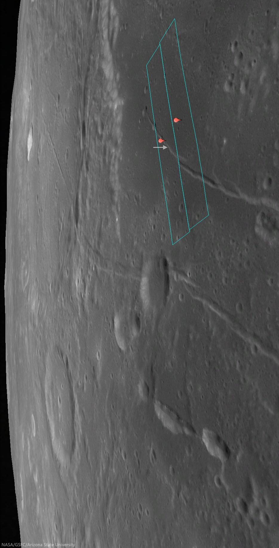
Location of the area viewed at high-resolution in the LROC NAC Featured Image (arrow) on the unnamed arcuate compression rille that runs almost parallel against Rima Hevelius I, longest of the Rimae Hevelius system and extending outward and beyond Hevelius crater, which is outside this 38 km-wide field of view; north of the pyroclastic vent structures near Lohrmann D. From LROC WAC observation M129716592C, LRO orbit 4249, May 28, 2010; 59.3° incidence angle, resolution 58.61 meters from 42.07 km [NASA/GSFC/Arizona State University].
This unnamed rille (0.141°N, 295.362°E), roughly 1 km across, is located on the edge of the southwestern region of Oceanus Procellarum.  As the mare deposits that formed Oceanus Procellarum cooled and contracted, fracture systems developed along the mare-highlands boundary. Near this boundary, loading of denser basalts (mare) over less dense crustal materials (highlands) results in tectonic stresses that can cause rock to pull apart along fractures, forming arcuate rilles.

The footprints of the left and right LROC NAC frames, from which the Featured Image was derived, installed on a digital elevation model and LROC Wide Angle Camera mosaic to offer a simulated 'real world' perspective, putting the the arcuate rille area of interest (arrow) in relation to Rimae Hevelius, inside and outside its namesake crater, and the other complexities of the Lohrmann and Hevelius pyroclastic area of the western equatorial border of Oceanus Procellarum [NASA/GSFC/Arizona State University].
The pattern of some of the complexities at the surface of west and southwest Oceanus Procellarum (and a lot of other areas on the Moon) were at least partially laid bare by the sensitive GRAIL A and GRAIL B gravity probes in 2012. Though the exact boundaries and morphology of the vast nearside basalt flood plain are still poorly understood, it's now clearer that the Moon once had its own "Ring of Fire," less dynamic than on Earth, but still a 'squarish' border in the form of deep volcanic rift structures partially surrounding an enormous plate. The inset shows how this system of rifts explains at least some of the surface faulting, the unique mountains and lateral pressures under the Hevelius, Rimae Hevelius, and the pyroclastic vents near Lohrmann D, and, indeed, much of the the western boundary of Oceanus Procellarum [NASA/GSFC/SVS].
The boulders on the floor of this rille are most likely material that has been eroding away from the walls. Some of the boulders reach diameters up to 12 meters. While an autonomous rover would likely require a lot of time to maneuver amongst the boulders, a human driver on the lunar surface might quickly and easily navigate a safe path around the boulders.

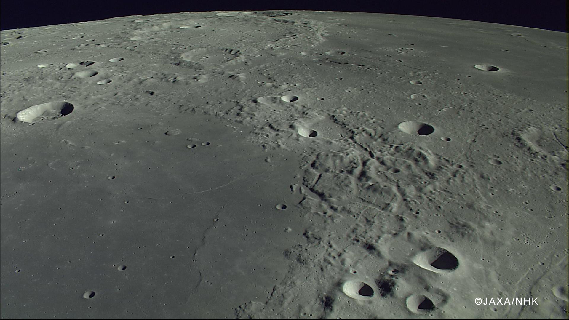
The compression rille is also visible, to the right of the upper center, east of Hevelius, north of the channel linking Grimaldi basin (lower left) with Procellarum (upper right), in this HDTV still captured by Japan's lunar orbiter Kaguya (SELENE-1) in 2007. See the full-size original image, HERE [JAXA/NHK/SELENE].
If you were an astronaut on the surface of the Moon, do you think you could find a safe path through this rille?  Trace your path on the full resolution LROC NAC below.

View full-window, HERE.

Related Posts:

Saturday, November 9, 2013

GRAIL twins put a new face on the Moon

GRAIL-crustal thickness, Olivine & KREEP
This graphic depicting the crustal thickness of the moon was generated using gravity data from NASA's GRAIL mission and topography data from NASA's Lunar Reconnaissance Orbiter [NASA/JPL-Caltech/IPGP].
Scientists using data from the lunar-orbiting twins of NASA's Gravity Recovery and Interior Laboratory (GRAIL) mission are gaining new insight into how the face of the moon received its rugged good looks. A report on the asymmetric distribution of lunar impact basins is published in this week's edition of the journal Science.

"Since time immemorial, humanity has looked up and wondered what made the man in the moon," said Maria Zuber, GRAIL principal investigator from the Massachusetts Institute of Technology in Cambridge. "We know the dark splotches are large, lava-filled, impact basins that were created by asteroid impacts about four billion years ago. GRAIL data indicate that both the near side and the far side of the moon were bombarded by similarly large impactors, but they reacted to them much differently."

Understanding lunar impact basins has been hampered by the simple fact that there is a lack of consensus on their size. Most of the largest impact basins on the near side of the moon (the moon's face) have been filled with lava flows, which hide important clues about the shape of the land that could be used for determining their dimensions. The GRAIL mission measured the internal structure of the moon in unprecedented detail for nine months in 2012. With the data, GRAIL scientists have redefined the sizes of massive impact basins on the moon.

Maps of crustal thickness generated by GRAIL revealed more large impact basins on the near-side hemisphere of the moon than on the far side. How could this be if both hemispheres were, as widely believed, on the receiving end of the same number of impacts?

Maps of the thickness of the Moon's crust from GRAIL data reveal the sizes of the Moon's great basins with unprecedented detail. The differences between the Moon's near and far sides run deep [NASA/JPL/MIT].
Scientists have long known that the temperatures of the near-side hemisphere of the moon were higher than those on the far side: the abundances of the heat producing elements uranium and thorium are higher on the near side than the far side, and as a consequence, the vast majority of volcanic eruptions occurred on the moon's near-side hemisphere.

"Impact simulations indicate that impacts into a hot, thin crust representative of the early moon's near-side hemisphere would have produced basins with as much as twice the diameter as similar impacts into cooler crust, which is indicative of early conditions on the moon's far-side hemisphere," notes lead author Katarina Miljkovic of the Institut de Physique du Globe de Paris.

The new GRAIL research is also helping redefine the concept of the late heavy bombardment, a proposed spike in the rate of crater creation by impacts about 4 billion years ago. The late heavy bombardment is based largely on the ages of large near-side impact basins that are either within, or adjacent to the dark, lava-filled basins, or lunar maria, named Oceanus Procellarum and Mare Imbrium. However, the special composition of the material on and below the surface of the near side implies that the temperatures beneath this region were not representative of the moon as a whole at the time of the late heavy bombardment. The difference in the temperature profiles would have caused scientists to overestimate the magnitude of the basin-forming impact bombardment.
Work by GRAIL scientists supports the hypothesis that the size distribution of impact basins on the far-side hemisphere of the moon is a more accurate indicator of the impact history of the inner solar system than those on the near side.

Launched as GRAIL A and GRAIL B in September 2011, the probes, renamed Ebb and Flow by schoolchildren in Montana, operated in a nearly circular orbit near the poles of the moon at an altitude of about 34 miles (55 kilometers) until their mission ended in December 2012. The distance between the twin probes changed slightly as they flew over areas of greater and lesser gravity caused by visible features, such as mountains and craters, and by masses hidden beneath the lunar surface.

NASA/JPL-CalTech news release by D.C. Agle of JPL, Dwayne Brown at NASA HQ and Sarah McDonnell of MIT.

Related Posts:
Thin crust Moon (April 24, 2013)
GRAIL - Lunar Reconnaissance Orbiter Science Update (March 24, 2013)
LAMP detects hydrogen and Hg in GRAIL impact plumes (March 19, 2013)
Graves of the GRAIL twins (March 19, 2013)
Parting shots from "Ebb" and MoonKAM prior to impact (January 10, 2013)
Impact on Mons Sally Ride, Ebb & Flow finale (December 17, 2012)
The surface of the Moon: What lies beneath? (December 11, 2012)
GRAIL twins coax out Moon, Solar System's deeper history (December 8, 2012)
JPL releases most detailed map of anomalous lunar gravity (December 5, 2012)
GRAIL twins uncover unexpectedly thin lunar crust (September 20, 2012)
GRAIL extended science mission begins (September 1, 2012)
Ebb & Flow complete primary mission (May 30, 2012)
Zuber shares lunar morphology insights at Harvard (April 20, 2012)
Flying Formation - Around the Moon at 5,800 kph (March 27, 2012)
GRAIL twins begin science mission (March 7, 2012)
The thinking behind the GRAIL twins (September 11, 2011)
GRAIL twins on their way (September 10, 2011)

Thursday, May 30, 2013

Origin of lunar MASCONS found in GRAIL data - JPL

The Moon's elusive, uneven gravity is clearly seen in this Free-Air Gravity map produced from data returned in 2012 by the twin GRAIL orbiters. Mare Imbrium, for example, at upper right presents a significant anomalous profile, concentrated near what may have been the original "transitory" crater boundary but equally reduced from the lunar average (blue) between that boundary and the outer reaches of Imbrium's present boundary [NASA/JPL/MIT].
Pasadena -- Investigators combing through the huge treasure trove of data returned to Earth by NASA's GRAIL (Gravity Recovery and Interior Laboratory) twin spacecraft Ebb and Flow in 2012 claim to have "uncovered the origin of massive invisible regions that make the moon's gravity uneven, a phenomenon affecting the stability and longevity of lunar-orbiting spacecraft," JPL announced Thursday.

"GRAIL data confirm that lunar mascons were generated when large asteroids or comets impacted the ancient moon, when its interior was much hotter than it is now," said Jay Melosh, a GRAIL co-investigator at Purdue University in West Lafayette, Ind., and lead author of the new research. "We believe the data from GRAIL show how the moon's light crust and dense mantle combined with the shock of a large impact to create the distinctive pattern of density anomalies that we recognize as mascons."

The origin of lunar mascons has been a mystery in planetary science since their discovery in 1968 by a team at NASA's Jet Propulsion Laboratory in Pasadena, Calif. Researchers generally agree mascons resulted from ancient impacts billions of years ago. It was not clear until now how much of the unseen excess mass resulted from lava filling the crater or iron-rich mantle upwelling to the crust.

On a map of the moon's gravity field, a mascon appears in a target pattern. The bulls-eye has a gravity surplus. It is surrounded by a ring with a gravity deficit. A ring with a gravity surplus surrounds the bulls-eye and the inner ring. This pattern arises as a natural consequence of crater excavation, collapse and cooling following an impact. The increase in density and gravitational pull at a mascon's bulls-eye is caused by lunar material melted from the heat of a long-ago asteroid impact.

"Knowing about mascons means we finally are beginning to understand the geologic consequences of large impacts," Melosh said. "Our planet suffered similar impacts in its distant past, and understanding mascons may teach us more about the ancient Earth, perhaps about how plate tectonics got started and what created the first ore deposits."

"Mascons also have been identified in association with impact basins on Mars and Mercury," said GRAIL principal investigator Maria Zuber of the Massachusetts Institute of Technology in Cambridge. "Understanding them on the moon tells us how the largest impacts modified early planetary crusts."

Launched as GRAIL A and GRAIL B in September 2011, the probes, renamed Ebb and Flow, operated in a nearly circular orbit near the poles of the moon at an altitude of about 34 miles (55 kilometers) until their mission ended in December 2012. The distance between the twin probes changed slightly as they flew over areas of greater and lesser gravity caused by visible features, such as mountains and craters, and by masses hidden beneath the lunar surface.

Wednesday, April 24, 2013

Thin Crust Moon

Map of the thickness of the Moon's crust from GRAIL mission gravity data. Mean thickness are estimated to be 34-43 km.
Paul D. Spudis
The Once and Future Moon
Smithsonian Air & Space


Imagine a system of molten silicate material, where low-density minerals float and higher density minerals sink.  Minerals rich in iron and magnesium (such as olivine and pyroxene) will settle toward the bottom of the magma body while those rich in the elements aluminum and calcium (such as plagioclase feldspar) will float.  Just such a scenario – on a global basis – is thought to have created the crust of the Moon.

Before Apollo, many believed that the Moon was a primitive, undifferentiated lump of cosmic debris.  By studying the samples returned by Apollo 11, scientists identified small fragments of white, plagioclase-rich rocks (anorthosite).  There are no known magma compositions corresponding to this rock type – anorthosite is created by removing low-density plagioclase from a crystallizing system and concentrating it by floatation.  From the evidence of fragments in the lunar soil, large amounts of anorthosite were inferred to be present in the nearby highlands of the Moon.  As the highlands make up more than 85% of the surface of the Moon, it was postulated that the crust of the Moon formed early in its history by global melting, an episode termed the “magma ocean.”

Expecting only minor volcanic activity and perhaps a local igneous intrusion, the concept of a global ocean of magma was surprising to most scientists.  Given its small size and consequent paucity of radioactive heat-producing elements, the idea that most of the Moon might have melted and differentiated was astounding.  The existence of an early magma ocean, which implied high-energy processes, provided us with clues to lunar origin.  Once it was recognized that the Moon had a crust, it was important to gain an understanding of its composition and physical nature.

On subsequent missions, Apollo astronauts were tasked with laying out a series of seismic stations across the near side.  These stations allowed us to measure “moonquakes” – both natural events as well as those created artificially by slamming spent rocket stages and satellites into the Moon.  Seismic recording allowed us to infer the speed at which seismic waves traveled through the lunar interior.  These estimated speeds indicated densities that implied composition, allowing us to deduce the probable chemical and mineral composition of the lunar interior.

The Apollo seismic network indicated that the crust of the Moon was about 50-60 km thick in the central near side, a surprisingly large value, especially compared to the thickness of the crust of the Earth (which varies from as thin as 5-10 km under the ocean basins to over 30 km in continental areas).  Such a thick crust for the Moon led to the postulation of a global magma ocean, as so much anorthosite could only be produced under the conditions of near global melting.  Subsequent studies incorporating gravity data from Lunar Orbiter and other missions suggested that the lunar crust is variable in thickness, with values exceeding 100 km in some regions of the far side highlands.

Re-analysis of the Apollo seismic data gave the first indication that those values might be overestimated.  Using modern techniques on these old data, new analysis revealed that the crust might be thinner than we had originally thought, on the order of 40-50 km thick.  This lower value of crustal thickness had some implications for estimating the bulk chemical composition of the Moon, but because it was considered to be a relatively minor adjustment, it caused no major difficulties for the rest of lunar science.

However, the recent GRAIL mission to the Moon (using high precision gravity mapping) ascertained the thickness of its crust to be 34-43 km.  Why should this new value worry some scientists?  Because we are now entering realms in which the new estimates of crustal thickness create consistency problems for other aspects of lunar science.  A crust as thin as 35 km on the near side of the Moon implies that the largest impacts – the multi-ring basins – should have excavated considerable amounts of material from the layer below the crust, the mantle of the Moon.  One might object that, as this region of the interior is inaccessible, we don’t know what the mantle would look like.  But in fact, the density constraints imposed by the seismic and gravity data dictate that it must be a rock type rich in iron and magnesium, made up mostly of the minerals olivine and pyroxene.  Such rocks are not unknown in the lunar collections, but they possess chemical and mineralogical characteristics indicating their origins at much shallower (crustal) depths.  In other words, there does not appear to be any material from the lunar mantle in the Apollo collections.  Given our obviously incomplete sampling of the Moon, should this be a problem?

Close view of a section of the central peak of Hausen crater (65.11°S, 271.5°E), among the few craters thought by some to have excavated more than 27 km and candidate for sampling below one of the thinner areas of the lunar crust. If the Moon's crust is as thin as GRAIL data indicate, however, why did basin-forming-impacts like Imbrium not appear to have excavated material from far deeper? LROC Narrow Angle Camera (NAC) mosaic M105100555LR, LRO orbit 643, August 16, 2009; angle of incidence 72.47° and 48 cm per pixel resolution, from 41.38 km [NASA/GSFC/Arizona State University].
Several Apollo landing sites (e.g., Apollo 14 and 15) were specifically chosen to maximize the chances of sampling ejecta from the enormous 1100 km diameter Imbrium basin (one of the biggest impact features on the Moon).  Virtually any reconstruction of the dimensions of the excavation cavity of this basin indicates that it should have dug up material from tens of kilometers depth, much deeper than the new value of crustal thickness implied by the GRAIL data.  So where is this debris from the mantle of the Moon?  True enough, it is possible that it may have been missed during the limited exploration time available to the Apollo crews, but the astronauts were trained to recognize such rocks and none were found.  Additionally, because we can map rock types by remote sensing (both from spacecraft and from Earth), we have an understanding of the regional distribution of rocks around these large impact features.  Despite a 30-year, exhaustively detailed search of the Imbrium impact basin (an area larger than Texas), we have found no convincing evidence for mantle material on the surface of the Moon.

So where does this leave us? In science, new data can solve some problems but at the same time, it may also create new ones.  Modern analyses of the old seismic data and new information on the Moon’s gravity field both suggest a relatively thin crust, with mantle material being very close to the surface (a few km) in some areas.  On the other hand, none of the ubiquitous impact basins and large craters of the Moon show evidence for mantle material in their ejecta, either in the Apollo collections or in remote sensing data.  Could our understanding of impact mechanics be completely wrong?  How could an event that formed an impact crater thousands of kilometers across excavate only a few kilometers deep?  Or are we misunderstanding the new gravity data?

Originally published April 24, 2013 at his Smithsonian Air & Space blog The Once and Future Moon, Dr. Spudis is a senior staff scientist at the Lunar and Planetary Institute. The opinions expressed are those of the author but are better informed than average.

Thursday, March 28, 2013

New Views of the Hollows of Rimae Sosigenes

The Rimae Sosigenes region of northwest Mare Tranquillitatis, from a mosaic of newly released LROC Narrow Angle Camera (NAC) oblique (slew -55°) observations M1108117962LR captured in orbit 15584, November 12, 2012. The field of view is roughly 43 km from west to east (left to right) and scaled up considerably from an original 2.5 meter resolution, imaged from 146 km distance (114.87 km over 8.63°N, 24.9°E, angle of incidence 70.37°).   The largest crater above, Sosigenes A at lower left, is 11.3 km in diameter [NASA/GSFC/Arizona State University].
Joel Raupe
Lunar Pioneer

Running behind this holiday week, we're still busy digging through the latest, 13th batch of Lunar Reconnaissance Orbiter (LRO) data uplinked to the Planetary Data System (PDS) last week. The latest 90 day batch covers September 15 - December 15, 2012, and we're still hopscotching through it like a bee in a springtime garden.

But I wanted to take a moment to talk about hollows. The subject came up at the just-completed 44th Lunar and Planetary Science Conference, last week, in formal discussions about hollows on Mars and Mercury, and that fact reminded me it's been almost exactly a year since the fascinating topic of "meniscus hollows" on the Moon was discussed here.

A new LROC NAC observation of the Rimae Sosigenes area, captured last November, stood out among the few newly-released side-glance, or "oblique," NAC footprints in the latest LROC PDS batch, providing a new perspective on lunar hollows that did not come up in the conversation last year.

Phil Stooke of Western Ontario University collected an excellent inventory of these apparent remnants of gaseous blow-outs and presented it to the 43rd LPSC, last year. He's come up with the designation 'meniscus hollows," as fine description as may be. Among those in his catalog is "No. 8," on the "floor of a depression." 

The new oblique LROC NAC observation assembled at the head of this post shows us how deep that depression really is. Like a necklace encircling the floor of that depression (which resembles a vent, as seen elsewhere on the Moon) where it joins the wall.

A closer look at what was once thought to be a 'chain of craterlets,' a minor catena, slicing perpendicularly through one of a system of parallel north to south rilles - likely faults, that run from Maclear to Sosigenes A. Closer examination in more recent surveys by the LROC Narrow Angle Camera seem to show this structure to be a vent, perhaps related to the faulting. The above is medium resolution sample from  LROC NAC  M1108117962LR [NASA/GSFC/Arizona State University].
Elsewhere we've seen these hollows as hints of relatively recent geological activity, on ancient plains or on small extrusive domes - yet here we seem to see hollows placed in context with a visible complexity of formations with which they may be related. Perhaps some of the other hollows, like those situated alone on the Tranquillitatis plains south of Ross crater and east of Sosigenes, north of Arago and its domes, are all related to conditions under the surface that will turn out at least as complex. 

We don't know enough about Mare Tranquillitatis. It's not clearly an impact basin, like Imbrium and neighboring Serenitatis. It should be interesting to eventually examine the finer detail of these formations in the deeper granularity of the GRAIL mission data.

At Sosigenes faults run south to north parallel with the northwest edge of the mare. Classified as linear rilles, a kilometer or more wide, one is bisected perpendicularly by an 18 km long "gash," hinting at the collapse or shifting under the surface. It is probably immensely old, though at some point the floor of the depression may have been intruded upon from below, perhaps by gases venting at what may have been a weak zone, where the steep 380 meter walls of the depression meet the floor.

In depressed zones east and west of the central "depression of interest," the contact zone joining wall and floor has been blurred by mass wasting. Perhaps in the central depression, however, the distinction was made by material being blown out around the central floor. If so, it's not readily apparent around the outer edge of the formation (which is not the same as saying it isn't there.) Where did it go?

This 580 by 800 pixel sample of the full resolution mosaic (LROC NAC M1108117962LR) shows the 380 meter depths of the elongated formation is punctuated by 'meniscus hollows' very similar to others found just to the east, at the surface of Mare Tranquillitatis south of Ross crater, and more famously at the Ina structure, much further west. Perhaps they most resemble 'hollows' on the floor of the central depression of Rima Hyginus. Found here at the contact zone between the structure's floor and walls, the primary surface seems characterized by a low crater count. Are these hollows points where gases have explosively uncovered the structure's original floor?  [NASA/GSFC/Arizona State University].
 Closer still, in the full-resolution close-up above, something stands out, much as it does at that most famous of the 'meniscus hollows,' Ina. You can make your own comparisons with another new LROC NAC oblique mosaic detailed further below.

In short, the material covering the central depression's floor at its interior, away from the encircling hollows, doesn't appear to share the saturation cratering superpositioned upon it that is more characteristic of the surrounding plain. In fact, like the beaded "frozen liquid' appearance of the material at Ina, it looks relatively new.

A look more or less straight down (and at much higher resolution) at the eastern interior of the 380 meter deep central depression, at its walls together with a small part of the surrounding Rimae Sosigenes plain. Under higher illumination angles the depths of the topography defies our intuition. It doesn't look as deep as it in the oblique view further above, illustrating once again how relief seems to disappear on the Moon in the absence of shadows. From earlier LROC NAC observation M152750200LR, orbit 7645, February 19, 2011; resampled from 0.47 cm per pixel resolution  - angle of incidence 35° - from 39.56 km [NASA/GSFC/Arizona State University].
And an even closer look at one of the hollows along the contact between floor and the steep walls of the central depression at Rimae Sosigenes. Small boulders - apparently - shed from the wall  (and a slope of collapsed talus is piled at right (easier to see in the oblique view above). This field of view, 335 meters wide, comes from LROC NAC observation M177508146LE, LRO orbit 11295, December 2, 2011; angle of incidence 69.92° (slew -14.8°) resolution 0.48 cm per pixel from 37.86 km [NASA/GSFC/Arizona State University].
Optical maturity is no help here, hinting that the newest material is either more than a billion years old or does not result from the kind of kinetic energies released by cratering. In the image above, at bottom center, runs another contact line between the slope of "older" debris from collapsed walls at bottom right and the "newer" material "beaded" at the depression's center.

Is there a difference in the crater count? The material on the slope at bottom right seems darker, but that is likely an illusion from shadow and the elephant skin on nearly every lunar sloped terrain. It hardly counts as a control sample for counting craters and their size and erosion, etc., but no obvious difference in ages stands out between the two zones - nor are there any boulders or trails on either patch of ground. Those seem almost exclusive to the interior of the "blown out" hollows.

Perhaps the best large scale comparison with the meniscus hollows of the Sosigenes depressions is the endlessly compelling Ina formation of Lacus Felicitatis. And that's as good a segue as any to another newly-released LROC NAC oblique observation of that much studied and barely understood feature just below.

A fresh LROC NAC oblique view the Ina formation and its surroundings, a challenge for telescopes on Earth. A closer look at this mosaic's rendition of Ina's distinctive "D" is shown immediately below. Note the apparent rising cone of Mount Agnes, to Ina's northwest. This mosaic is assembled from LROC NAC M1108203502LR, exposing a field of view also roughly 43 km across, with both spacecraft and camera slewed -53°), looking west from 127.29 km over 18.77°N, 11.64°E, Sulpicius Gallus and southern Mare Serenitatis were directly below LRO, outside this side-looking view [NASA/GSFC/Arizona State University].
Perhaps it's a toss-up whether Ina or the hollows on the floor of the central depression of Rima Hyginus more closely resemble the hollows at Rimae Sosigenes. Perhaps the latter is something in-between. 

The view of Ina at an oblique angle, above and below, captured more than 140 km away from the LROC cameras, is not our most detailed look at that formation. Some unscaled examples of the very closest views of Ina surfaced with the LROC PDS release in December 2011. There doesn't seem to be much in the way of a depression resulting from the forces that created Ina, though the beaded remnants or surfacing seems to closely resemble the floor of the Rimae Sosigenes depression.

A new angle on the Ina (3 km across, 18.65°N, 5.3°E) from the immediately preceding mosaic sampled at its full 2.6 meter per pixel resolution [NASA/GSFC/Arizona State University].
Over the next decade or so, when researchers have time to weave together data collected by LROC, Mini-RF and from the GRAIL twins, a better picture of these 'meniscus hollows' will likely emerge. In the end, the formations themselves may turn out to be the surface manifestation of something deeper that we can hardly imagine today.

Related Posts:
Inside Rima Hyginus (June 12, 2012)
Whale of a Hollow (March 20, 2012)
Ina of the Meniscus Hollows (March 21, 2012)
The closest of lunar close-ups (December 16, 2011)
It's a gas, man (October 8, 2011)
Spectral Properties of Ina (February 7, 2011)

Tuesday, March 19, 2013

Graves of the GRAIL twins

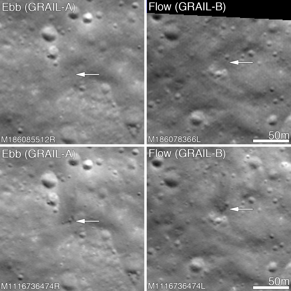
Before and after the GRAIL twins impacts on the Moon December 17, 2012. The LROC Narrow Angle Camera (NAC) directors were able to resolve the impact sites on February 28, 2013, revealing both to be about 5 meters in diameter. Upper panels show the area before the impact; lower panels after the impact. Arrows point to crater locations. LROC NAC observations M186085512R, M186078336L, M1116736474R and M1116736474L. Full size Featured Image HERE  [NASA/GSFC/Arizona State University].
Jeffrey Plescia
LROC News System

The Gravity Recovery and Interior Laboratory (GRAIL) mission ended on 17 December 2012 at 14:28 PST (-8 hrs. relative to Universal Time) when the two spacecraft GRAIL A (Ebb) and GRAIL B (Flow) impacted the Moon.

Both impact sites lie on the southern slope of an unnamed massif (mountain) that lies south of the crater Mouchez and northeast of the crater Philolaus.

The massif stands as much as 2500 m above the surrounding plains. The impact sites are at an elevation of about 750 and 1040 meter, respectively, about 460-750 m below the summit.

Artist conception of the orbital track of the two spacecraft just before impact. Both spacecraft were tracking north as their altitude continuously decreased until they impacted the south side of the massif [NASA/JPL].
The two GRAIL spacecraft were relatively small - cubes about the size of a washing machine with a mass of about 200 kg (441 lbs) at the time of impact. When they arrived at the Moon their mass was closer to 278 kg (619 lbs), but about 78 kg (172 lbs) of that was fuel consumed during lunar operations. Both spacecraft impacted at very low angles (~2° to the horizontal) at about 1600 m/s (faster than a speeding bullet) into a fairly steep slope! LROC images reveal that both spacecraft formed craters about 5 m (15 ft) in diameter. Surprisingly, the ejecta around both craters is dark and irregularly distributed around the crater; there is little ejecta to the south - the direction from which the spacecraft were traveling.

GRAIL A site seen before and after the impact event. Crater center is located at 75.609°N, 333.407°E [NASA/GSFC/Arizona State University].
Typically ejecta from craters has a higher reflectance than the target material (think of the rays of Tycho). This normal contrast is due to the excavation of fresh (or immature) soil from beneath a more mature, weathered layer. As the lunar regolith is exposed to the vacuum of space, it suffers exposure to cosmic radiation, solar wind bombardment, and micrometeorite impacts. Slowly over time, these processes tend to darken the soil. Thus, if you dig down beneath the surface you will find higher reflectance soil.

GRAIL B site seen before and after impact event. Crater center is located at 75.651°N, 333.168°E [NASA/GSFC/Arizona State University].
So why do both GRAIL craters exhibit low reflectance rays? Perhaps we are seeing carbon from the spacecraft. The structure was made of a cyanate ester composite (carbon rich) and other materials also had carbon as primary compounds. Additionally, there was about 0.5 kg (1.1 lbs) of fuel remaining in each spacecraft. Due to the energy of impact, the carbon from these varied sources may have been released and mixed with and coated the ejecta. It takes only a very small amount of carbon to darken a material, recall in art class when you put just a few drops of black paint into a lighter color and it went all muddy. But right now we do not know for sure the cause of this interesting anomaly!

LRO Wide Angle Camera (WAC) image of the GRAIL impact area on the south side of the unnamed massif. LRO WAC M120020350 [NASA/GSFC/ASU].
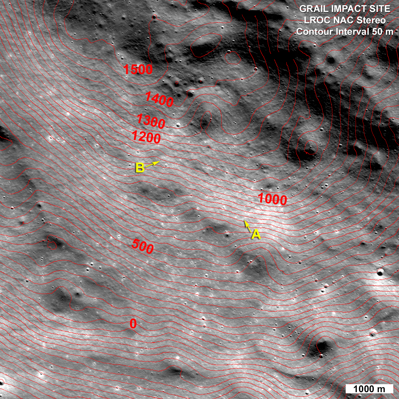
On 28 February 2013 the LROC obtained a stereo pair for the impact area and from these images the LROC team produced a controlled preliminary topographic map. From the stereo model latitude, longitude and elevation were derived for each impact crater: GRAIL A 75.609°N, 333.407°E, 750 meters and for GRAIL B 75.651°N, 333.168°E, 1040 meters. The local slope of the mountain at the point of impact was 23° for GRAIL A and 19° for GRAIL B. As knowledge of the spacecraft position is refined the LROC team will update these coordinates. The two impact craters are about 2210 m apart; GRAIL B impacted about 20 seconds after GRAIL A at a site to the northwest of GRAIL A.

LROC NAC stereo derived topographic map of the GRAIL Impact area, map is 8400 meters wide, north is up [NASA/GSFC/Arizona State University].
Find the GRAIL impact craters in the full NAC image, HERE.

Related Posts:
Parting shots from Ebb MoonKAM prior to impact
Ebb and Flow Finale
Rocket Impacts Recorded by the Apollo Seismic Network
Apollo 14 S-IVB Impact Crater
Mountains of the Moon
LROC Coordinates of Robotic Spacecraft
Ejecta Sweeps the Surface

Thursday, January 10, 2013

Parting shots from "Ebb" MoonKAM prior to impact

Three days prior to its planned impact on a lunar mountain, mission controllers activated the camera aboard one of NASA's GRAIL twins to take some final photos from lunar orbit.  The video, released by JPL January 10, is from the GRAIL MoonKAM (Moon Knowledge Acquired by Middle School Students) cameras aboard "Ebb," December 14, 2012. The spacecraft was winding down in its polar orbit, still approximately 10 km above the northern hemisphere of the lunar farside, in the vicinity of Jackson crater.  "This imagery was acquired as part of a final checkout of the spacecraft systems prior to the "Sally Ride" impact site, December 17." [NASA/JPL/Sally Ride Science].

Embedded video from JPL

Monday, December 17, 2012

Impact on Mons Sally Ride, Ebb & Flow Finale

Ebb and Flow Finale - The two GRAIL spacecraft, Ebb and Flow, as imaged by the LROC NAC in lunar orbit at different times (A on 7th October, B on 8th October 2012) [NASA/GSFC/Arizona State University].
Mark Robinson
Lunar Reconnaissance Orbiter Camera
Principal Investigator


The Gravity Recovery and Interior Laboratory (GRAIL) spacecraft are nearing the end of their mission. Launched in September of 2011, these two intrepid spacecraft have mapped the lunar gravity field in unprecedented detail, a boon for lunar scientists! However, they have expended their fuel reserves, and both will make controlled crashes onto the lunar surface today.

During their one year mission the GRAIL spacecraft often came close to LRO, in some cases the distance was less than 10 km! On 7 October 2012 as GRAIL A passed within 11 km, LRO pitched forward 30° and and rolled 16° to snap an image as the Sun glinted off Ebb's solar panels and main deck. The next day a similar opportunity presented itself and LROC imaged GRAIL B.

GRAIL A sketch - Rough sketch showing orientation of GRAIL A (Ebb) as seen from LROC on 7 October 2012, dimensions are in cm, the roll angle was 16° (not 15°) [A. Boyd, ASU].
In both instances the orbit track of the GRAIL spacecraft was angled by 120° relative to LRO's orbit, and the twin spacecraft passed below LRO in the lunar night. Since the LROC NAC is a line scanner, it builds up an image line-by-line, and depends on the spacecraft to orient its CCD sensor perpendicular to the ground path. In the case of the GRAIL images, LRO was not reoriented so the images are distorted, the slews added to the distortion. Using spacecraft ephemeris, the distorted image of GRAIL was corrected back to a normal geometry.

Uncorrected and corrected GRAIL A - GRAIL A (Ebb) in the uncorrected native geometry (top), and geometrically corrected (bottom), LROC NAC M1104211640 [NASA/GSFC/Arizona State University].
Ebb and Flow will impact a 2400 meter (7874 feet) tall mountain, about 450 km from the lunar north pole, at approximately 2:28 PM PST, (22:28:40 & 22:29 UT) Monday 17 December 2012. Antennas on Earth will be tracking both spacecraft until the moments of impact. The last few orbits will be very low, and may provide some extremely high resolution gravity profiles. Just before impact, the two spacecraft will come astonishingly close to a ridge between 71°N and 72°N (see WAC mosaic further below).

Planned impact site for the GRAIL twin orbiters, 20 seconds apart, 2229 UT, 17 December. Field of view roughly 17 km across, from a mosaic of the left and right frames from LROC Narrow Angle Camera (NAC) observation M188437321LR, LRO orbit 12830, April 7, 2012 [NASA/GSFC/Arizona State University].
GRAIL impact zone from global Chang'E-2 60 meter mosaic [CNSA/CLEP].

The two GRAIL spacecraft are identical, and each has a mass (without fuel) of about 130 kg (287 lbs). When they hit the mountain at about 1.6 km/sec (3579 mph), they will each make small impact craters, about a meter across. The craters will be too small to resolve with LROC, but the bright ejecta around those craters, which should be a few meters across, might be visible. Optimal lighting for future LROC imaging of the GRAIL craters will occur next March through April (2013).

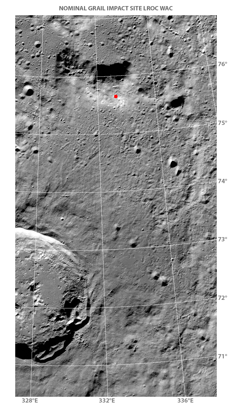
LROC WAC mosaic of GRAIL Impact Site - Ebb and flow will come in from the south, fast and low, and impact the tall mountain indicated with red dot. A few moments before impact they streak just above a high ridge. Imagine the view! LROC WAC mosaic sampled at 160 meters per pixel [NASA/GSFC/Arizona State University].
View the low-resolution WAC mosaic, HERE.
Download a 60 meter/pixel version of the WAC mosaic, HERE.
Download a 10 meter/pixel closeup mosaic of the Nominal GRAIL Impact Site, HERE.

Friday, December 14, 2012

Appearance of the Moon during the GRAIL impacts

GRAIL's Final Resting Spot.  These maps of Earth's moon highlight the region where the twin spacecraft of NASA's Gravity Recovery and Interior Laboratory (GRAIL) mission will impact on Dec. 17, marking the end of its successful endeavor to map the moon's gravity. The two washing-machine-sized spacecraft, named Ebb and Flow, will impact an unnamed mountain above of 75°N. [NASA/GSFC/Arizona State University].
Pasadena (JPL) -- Twin lunar-orbiting NASA spacecraft that have allowed scientists to learn more about the internal structure and composition of the moon are being prepared for their controlled descent and impact on a mountain near the moon's north pole at about 2028 UT (5:28 p.m. U.S. EST) Monday, December 17.

Ebb and Flow, the Gravity Recovery and Interior Laboratory (GRAIL) mission probes, are being sent purposely into the lunar surface because their low orbit and low fuel levels preclude further scientific operations. The duo's successful prime and extended science missions generated the highest-resolution gravity field map of any celestial body, providing a better understanding of how Earth and other rocky planets in the solar system formed and evolved.
Perspective on the Moon at the estimated time of the GRAIL impacts, projected at 2229 UT, 17 December 2012. Waxing between New and First Quarter (4.58 days 26.8% illumination), the distance between Earth and Moon will be increasing at roughly 10 km per minute from 372,628 kilometers. In eastern North America, the Moon will have transited, riding low and west from overhead Only the best equipped observers can hope to observe the actual release of kinetic energy, an extremely fast flash, near the horn of the north-northwest limb [Virtual Moon Atlas].
"It is going to be difficult to say goodbye," said GRAIL principal investigator Maria Zuber of the Massachusetts Institute of Technology in Cambridge. "Our little robotic twins have been exemplary members of the GRAIL family, and planetary science has advanced in a major way because of their contributions."

Lunar Heritage Sites and GRAIL's Final Mile. This graphic highlights locations on the moon NASA considers "lunar heritage sites" and the path NASA's Gravity Recovery and Interior Laboratory spacecraft will take on their final flight. Navigators on the GRAIL team have designed an end of mission plan that rules out the extremely remote possibility of either of the two GRAIL spacecraft impacting near any of these historic locations. The Apollo 11, 12, 14, 16 and 17 landing sites are indicated with green circles. The Surveyor sites are indicated with yellow squares. The Soviet Union's Luna and Lunakhod landing sites are indicated with red diamonds and red squares, respectively.  The ground track for the Ebb and Flow spacecraft during their final half-orbits is shown in black. The maps are color-coded by topography. Red and white indicate the high areas. Blue and violet indicate low areas [NASA/JPL-Caltech].

The mountain where the two spacecraft will make contact is located near a crater named Goldschmidt. Both spacecraft have been flying in formation around the moon since Jan. 1, 2012. They were named by elementary school students in Bozeman, Mont., who won a contest. The first probe to reach the moon, Ebb, also will be the first to go down, at 2:28:40 p.m. PST. Flow will follow Ebb about 20 seconds later.

Both spacecraft will hit the surface at 3,760 mph (1.7 kilometers per second). No imagery of the impact is expected because the region will be in shadow at the time.

Ebb and Flow will conduct one final experiment before their mission ends. They will fire their main engines until their propellant tanks are empty to determine precisely the amount of fuel remaining in their tanks. This will help NASA engineers validate fuel consumption computer models to improve predictions of fuel needs for future missions.

"Our lunar twins may be in the twilight of their operational lives, but one thing is for sure, they are going down swinging," said GRAIL project manager David Lehman of NASA's Jet Propulsion Laboratory in Pasadena, Calif. "Even during the last half of their last orbit, we are going to do an engineering experiment that could help future missions operate more efficiently."

Because the exact amount of fuel remaining aboard each spacecraft is unknown, mission navigators and engineers designed the depletion burn to allow the probes to descend gradually for several hours and skim the surface of the moon until the elevated terrain of the target mountain gets in their way.

Ebb and Flow's Final Moments. These side-by-side, 3-D comparisons depict the unnamed lunar mountain targeted by the NASA's Gravity Recovery and Interior Laboratory (GRAIL) mission for controlled impact of the Ebb and Flow spacecraft. They also include the ground tracks the spacecraft are expected to follow into the lunar terrain. These graphics were generated using data from the Lunar Orbiter Laser Altimeter instrument aboard NASA's Lunar Reconnaissance Orbiter spacecraft. On the left is the mountain with the ground track and mission termination point for the Ebb spacecraft. On the right is the mountain, ground track and mission termination point for the Flow spacecraft [NASA/JPL-Caltech/MIT/GSFC].

The burn that will change the spacecrafts' orbit and ensure the impact is scheduled to take place Friday morning, Dec. 14.

"Such a unique end-of-mission scenario requires extensive and detailed mission planning and navigation," said Lehman. "We've had our share of challenges during this mission and always come through in flying colors, but nobody I know around here has ever flown into a moon mountain before. It'll be a first for us, that's for sure."

During their prime mission, from March through May, Ebb and Flow collected data while orbiting at an average altitude of 34 miles (55 kilometers). Their altitude was lowered to 14 miles (23 kilometers) for their extended mission, which began Aug. 30 and sometimes placed them within a few miles of the moon's tallest surface features.

The published impact coordinates for the GRAIL twins has been well-surveyed by the Lunar Reconnaissance Orbiter Camera (LROC), at least nine times at high-resolution. LROC QuickMap 125 meter resolution [NASA/GSFC/Arizona State University].
JPL manages the GRAIL mission for NASA's Science Mission Directorate in Washington. The mission is part of the Discovery Program managed at NASA's Marshall Space Flight Center in Huntsville, Ala. Lockheed Martin Space Systems in Denver built the spacecraft. JPL is a division of the California Institute of Technology in Pasadena.

For more information about GRAIL, visit: http://grail.nasa.gov and http://www.nasa.gov/grail.

Thursday, December 13, 2012

MoonKAM video of LRO in orbit, GRAIL twins to be deorbited Monday


Embedded video from NASA Jet Propulsion Laboratory California Institute of Technology, "first footage of one orbiting robotic spacecraft taken by another orbiting robotic spacecraft at Earth's moon."
 
NASA's Lunar Reconnaissance Orbiter (LRO) is captured by one of the MoonKAM cameras from GRAIL twin space craft "Flow," last May 3, from a distance of a mere 20 kilometers, turning the tables on the spacecraft that photographed so many artifacts of human exploration on the lunar surface since 2009.
GRAIL twins set for controlled impact near the Moon's north pole, around 2228 UT, Monday, December 17

LRO has orbited the Moon more than 15,800 times during more than three years in polar orbit, its flight directors having long ago smashed all previous records for maintaining any vehicle in lunar orbit, while each day continuing to set a new record for total data returned by all existing and previous deep space missions combined.

The somewhat less robust GRAIL twins, including "Flow," (nee GRAIL B), are to be deorbited around 2229 UT, Monday, December 17, somewhere near the Moon's north pole, following a successful mission lasting slightly under a year. But because of the remarkably detailed models of the Moon's anisotropic gravity fields, build up from the GRAIL survey, future lunar missions (including communications satellites relaying data from the Moon's farside), function more efficiently and stay in orbit longer.

An ironic high-water mark for the U.S. commitment to "precursor" missions ahead of establishing an "extended human presence" on the Moon begun in 2004, as of next Monday the number of American unmanned vehicles in lunar orbit will fall from five to three.

Tuesday, December 11, 2012

The surface of the Moon: What lies beneath?

The Moon's anisotropic composition is well represented in this Mercator projection of lunar gravity, mapped at unprecedented resolution by the twin GRAIL lunar orbiters and centered on the Moon's farside [NASA/JPL/MIT].
Paul D. Spudis
Smithsonian Air & Space

The NASA mission GRAIL (Gravity Recovery And Interior Laboratory) has been orbiting the Moon since last spring.  The mission consists of two identical small spacecraft (dubbed Ebb and Flow) that very carefully keep track of their relative position from each other.  By tracking both of these spacecraft with high precision from Earth, we can monitor any small variations (caused by variations in the Moon’s gravity field) away from their predicted orbital paths.  If the satellite is flying over an area on the Moon with less material than normal (for example, over a deep crater, a hole in the Moon’s crust), it will be less attracted to the Moon because of this mass deficiency and will therefore fly away from the Moon.  If, on the other hand, it flies over an area of excess mass, such as a thick stack of dense lava flows, the excess mass pulls the satellite slightly toward it, increasing its speed and pulling it downwards.  As Ebb and Flow orbit the Moon, they conduct a delicate “dance.”  These movements are caused by variations in the Moon’s gravity (largely a reflection of variations in the density of its crustal rocks).  When combined with the high-resolution, precision topography of the Moon (currently being gathered by the Lunar Reconnaissance Orbiter), we are able to reconstruct the structure and thickness of the lunar crust from orbit.

GRAIL has unveiled a new global gravity data set, very high in resolution and precision and greater than ten times better than our previous version of the global gravity from the Japanese mission SELENE (Kaguya).  One interesting result shows unusual structure – long, quasi-linear gravity features appear in a variety of locations associated with lunar impact basins.  Basins are very large craters that formed during asteroid collisions prior to 3.8 billion years ago.  Some of these linear features extend on great circles across the lunar globe for distances of more than 500 km. These results suggest that solidified intrusions of once-molten rock may form a dense, criss-crossing network within the upper crust.

In order to understand the significance of these gravity features, it is necessary to understand some elementary facts about planetary geology.  Planets generate heat and this heat must be dissipated.  Typically, the heat generated from both the original energy release during formation (accretion) and from the decay of radioactive elements (e.g., uranium) melts the interiors of planets, forming bodies of liquid rock called magma.  This magma is usually less dense than the rocks from which it forms and thus, rises upwards towards the surface.  Sometimes, the molten rock cannot ascend any higher from the deep locations where it comes from and freezes in place – geologists call this type of frozen rock body an intrusion, because it intrudes into pre-existing rock as a liquid and then solidifies by crystallizing.  When magma actually reaches the surface of a planet, it can erupt onto its surface as lava; this activity is called extrusive because the molten rock extrudes onto the surface and then solidifies as lava flows.

Clearly, all erupting lava must have at one time been an intrusive magma body, at least during the time it was ascending upwards toward the surface.  Although many magma bodies reach the surface and create lava flows (such as the dark, smooth maria of the lunar lowlands), sometimes this magma cannot reach the surface and freezes in place within the crust as a linear or tabular body.  Such features (called dikes) are an essential part of the underground, igneous plumbing of volcanoes on all of the terrestrial planets.  We knew that they must have formed on the Moon because we saw the evidence of vents and structures in the maria that are the surface expression of such features.

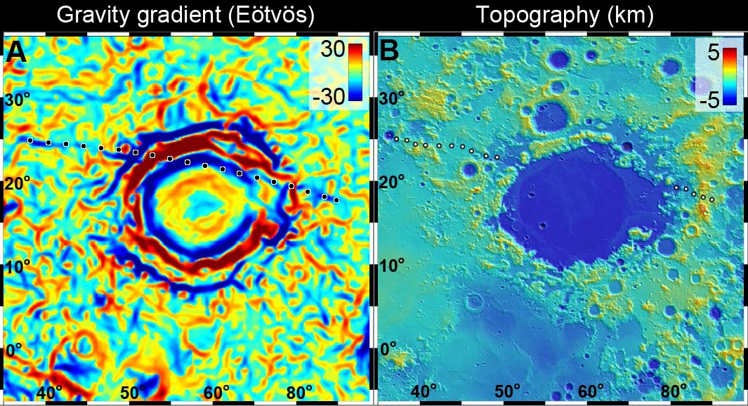
For the first time, the new GRAIL data show us direct evidence for these buried igneous dikes within the lunar crust.  One particularly prominent dike occurs near the Crisium basin, on the eastern near side of the Moon.  This dike extends over 1000 km in a quasi-radial direction northwest of the Crisium rim, disappearing beneath the mare lavas of that basin.  The fact that it is not clearly aligned with the basin structure suggests that it may predate it; we estimate that Crisium basin is older than 3.9 billion years.

Newly released GRAIL lunar gravity gradient map centered on Mare Crisium. An otherwise essentially invisible 300 km-long density of mass was detected buried under 3.9 billion year old Crisium (dotted line) [NASA/JPL/MIT].
Small scale topography of the Crisium basin, assembled from laser data points collected by the LOLA instrument aboard the Lunar Reconnaissance Orbiter [NASA/GSFC].
Mare Crisium and vicinity in a monochrome 1240 km-wide field of view from the LROC Wide Angle Camera 100 meter resolution global mosaic [NASA/GSFC/Arizona State University].
This long linear feature may have been formed when molten magma from the deep interior of the Moon oozed its way toward the surface, before “freezing” at some intermediate level.  Its presence, evident now only by a faint gravity signature (those denser areas “tugging” on the GRAIL satellites “Ebb” and “Flow”), is a tell-tale remnant of its existence deep inside the Moon’s crust.

The highly-detailed GRAIL lunar gravity gradient orthographic map, centered near 60° E meridian (and Mare Crisium, above center). The third of the hemisphere at right is on the Moon's farside. To view the spectacular new animations at their highest-available resolution by visiting the Science Visualization Studio (SVS) at NASA Goddard Space Flight Center, HERE [NASA/JPL/MIT/GSFC/SVS].
Many other linear and circular features are evident in the gravity gradient map produced by GRAIL.  Most of these seem to be associated with the large basins of the lunar highlands, the largest impact craters on the Moon. These features both excavate large amounts of crustal material during formation, and serve as topographic lows and structural traps for the accumulation of subsequent erupted lavas.  The gradient structures show a complex network of density patterns in the shallow subsurface of the Moon; this area is a morass of crushed rock, fractures, large faults and collapse features.  The entire outer portion of the lunar crust has been shattered and broken by an impact barrage of almost unimaginable violence.  The crust has since been partly annealed together by heat, re-fractured by additional impacts, intruded by large bodies of molten rock, resurfaced by the eruption of lavas from the deep interior, and finally has had its outermost surface pulverized into a fine powder by the micrometeorite bombardment.

The Moon may look like a silent, dead world but its past (which is Earth’s past) is testament to an early history of extreme violence and chaos.  The results from the GRAIL mission are helping us understand this complex story.

Originally published at his Smithsonian Air & Space blog The Once and Future Moon, Dr. Spudis is a senior staff scientist at the Lunar and Planetary Institute. The opinions expressed are those of the author and are better informed than average.