Friday, March 30, 2012

LROC: Splish Splash

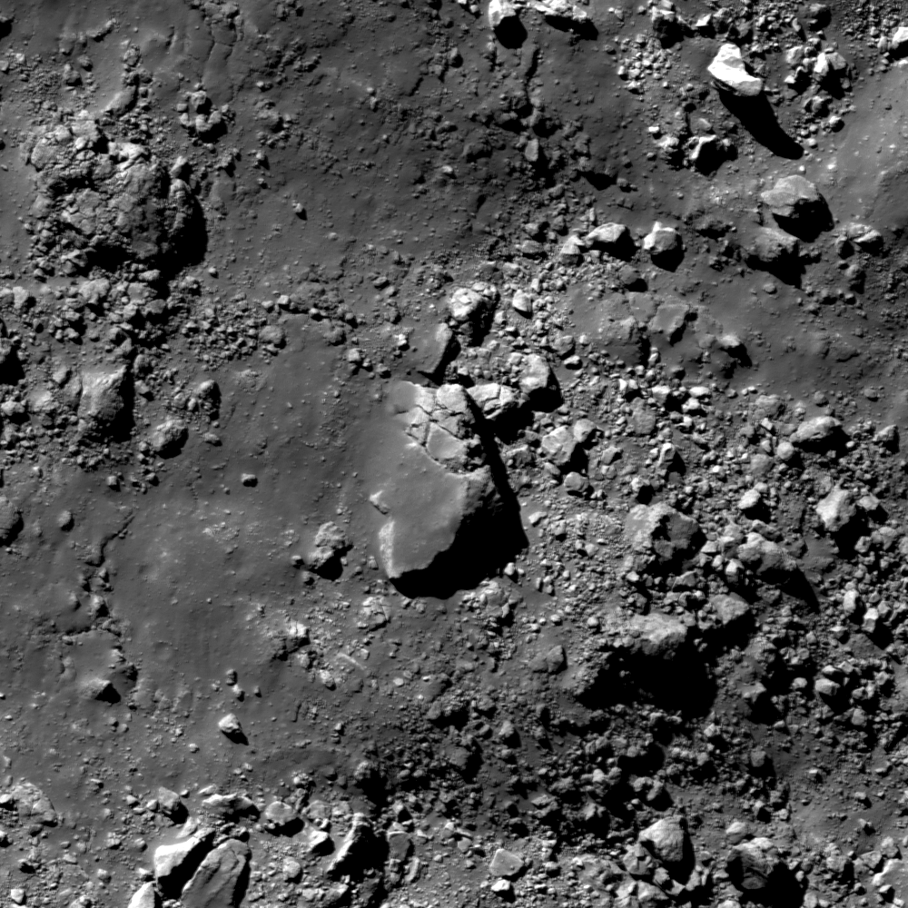
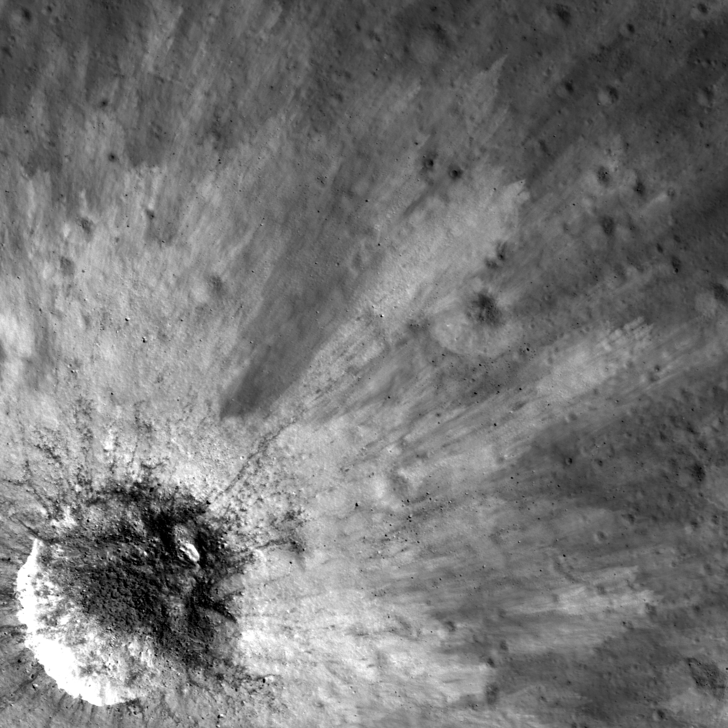
An impact melt veneer coating a large boulder, roughly 80 meters by 120 meters in size, larger than a football field! Downslope to the right, LROC Narrow Angle Camera (NAC) observation M169630027R, orbit 10132, September 2, 2011; image field of view is 530 meters across, inclination 47.19° at 0.56 meters resolution from 54.5 kilometers overhead. View the larger LROC Featured Image HERE [NASA/GSFC/Arizona State University].
Lillian Ostrach
LROC News System

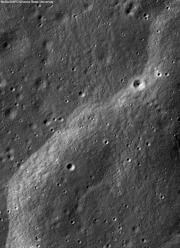
Ryder crater (43.877°S, 143.246°E, ~15 km diameter) is a Copernican-aged crater located within the South-Pole Aitken basin. A pond of impact melt is present on the crater floor, and boulders and melt streamers pepper the crater rim. Taking a look at the crater wall just interior to the rim (opening image), the wall is littered with boulders of varying sizes and shapes as well as areas smoothed by impact melt flows and veneers. Even though substantial ejecta and impact melt were deposited exterior to the crater, the rim and immediate surroundings were also littered with vast quantities of ejected material and impact melt. Today's Featured Image displays the complicated relationship between impact melt and ejecta emplacement, specifically around the crater rim.

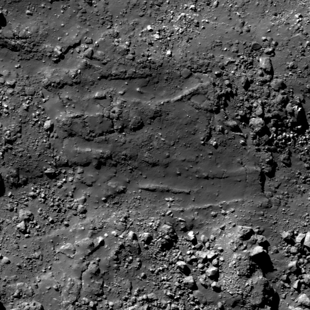
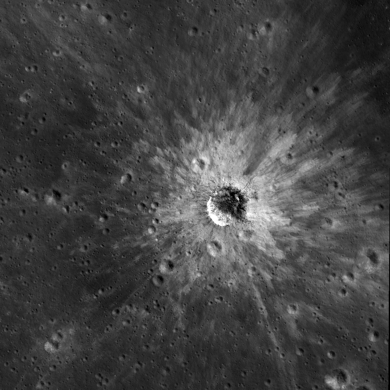
Interspersed with melt-covered boulders are sections of impact melt channels (43.878°S, 143.021°E). Erosion over time has fractured and fragmented the channels and not many areas like the one pictured above are visible in this image. Downslope to the right, NAC M1696330027R, field of view 530 meters; view the full sized image HERE [NASA/GSFC/Arizona State University].
In some places, the crater wall is very smooth, indicating that the impact melt deposited was thick enough to bury the fractured wall material. However, as observed in the opening and above images, jumbles of boulders and fragmented ejecta are interspersed among impact melt-smoothed surfaces. Many of these boulders are veneered with impact melt where a thin layer of impact melt splashed onto the surface of the rock and solidified, and some boulders are partially buried within the smoother regions of impact melt. Some boulders do not appear to have impact melt veneers at all - why might that be? Furthermore, channels formed in some places that allowed impact melt to flow from the crater rim back toward the crater floor.

HDTV still looking north over Ryder crater from Japan's lunar orbiter Kaguya (SELENE-1, 2009). By way of Charles Wood's Lunar Picture of the Day (LPOD), December 26, 2009 [JAXA/NHK/SELENE].
Unlike other channels, those observed in the above image are not as well-formed, suggesting that less melt utilized these pathways and perhaps the impact melt had cooled substantially as it flowed back into the crater so that it was not able to flow quickly nor hot enough to maintain thermal erosion in the channels. However, as seen in the above image, the channel halts abruptly in the downslope direction (right side of the image). What could be the cause?

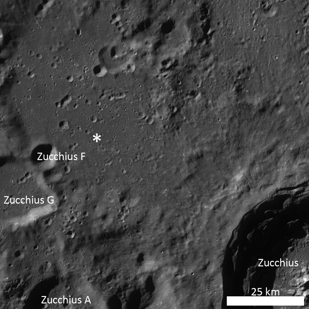
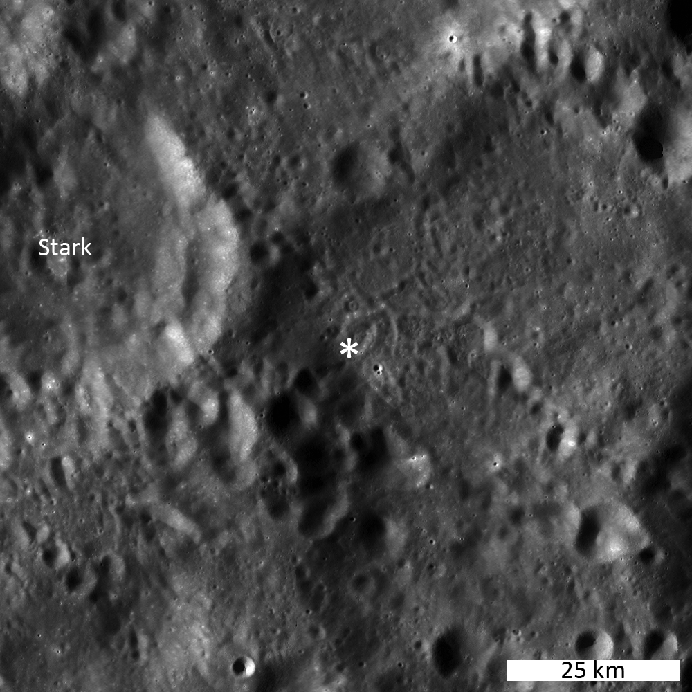
LROC WAC monochrome mosaic of Ryder crater. Note the massive slump originating from the eastern wall and the pond of impact melt on the crater floor. Asterisk notes location of opening image (43.895°S, 142.988°E). View the LROC context image HERE [NASA/GSFC/Arizona State University].
The answer to both the halted channel and presence of boulders without melt veneer is that erosion has taken place since Ryder crater formed. Simply put, things (rocks) like to move downhill. Over time, boulders from the crater rim and higher up on the crater walls dislodged and traveled toward the crater center. While some of these blocks do not have impact melt veneers now, they may have in the past, but their downhill travels may have fractured those blocks even further so that any melt veneer present cracked off or was left behind on another fragment. Take a look at the central boulder in the opening image; although the majority of the boulder face visible has an impact melt veneer, there are fractured areas of the block that do not. Additionally, crater wall erosion may be invoked as an explanation for the apparent halt in the impact melt channel. Observations of the cracks perpendicular to the channel flow direction suggest that the jagged edge of the channel (middle-right) probably cracked off and fragmented to fall toward the crater floor. Or perhaps the ejecta blocks entrained within the melt that formed the channel dislodged and carried the lower portion of the channel downhill.

How many different impact melt features and morphologies do you observe when you traverse the entire LROC NAC frame, HERE? In case you missed it, and be sure to check out the LROC NAC oblique view of Ryder crater, released this past week, HERE.

Related Posts:

Farside impact!
On the Floor of Thales
Lichtenberg B Flow
Impact melt channel

Thursday, March 29, 2012

LROC: Not your average scarp

A scarp winds through an interestingly wrinkled region of mare amidst the Zucchius crater group. LROC Narrow Angle Camera (NAC) observation M166223945L, field of view width = 560 meters, LRO orbit 9630, July 25, 2011; incidence angle 75.61° at a resolution of 0.97 meters per pixel from 46.45 kilometers. View the enlarged LROC Featured Image HERE [NASA/GSFC/Arizona State University].
Lillian Ostrach
LROC News System


This lobate scarp wends through a region of mare basalts, but you will be surprised to know that the location of this image is on the lunar farside (59.921°S, 304.456°E), northwest of Zucchius crater. Even though the farside is not well known for vast deposits of mare like the nearside, there are regions of volcanically flooded terrain. Today's Featured Image highlights such an area, where contractional forces caused the mare materials to break along a fault and thrust upward, and the lobate scarp is the surface expression of slip on the fault. However, lobate scarps usually occur in the highlands and wrinkle ridges (another contractional tectonic landform) usually occur in mare regions. So why is a lobate scarp observed in this region of mare basalts?

LROC Wide Angle Camera monochrome (604nm) mosaic showing a roughly 34 km-wide field of view surrounding the area spotlighted at high-resolution in the LROC Featured Image (dead center) under early daylight illumination, in sharp relief. The scarp formation northeast of Zucchius F (lower left) is extensive and highly visible. Image derived from six sequential WAC observations, orbits 11367-11372, December 9, 2011; average incidence 81.5° at 58.38 meters resolution from 42.94 kilometers [NASA/GSFC/Arizona State University].
Lobate scarps are thought to form from global contraction of the Moon, as its still hot interior cools. In contrast, wrinkle ridges - while contractional features - probably formed by a combination of faulting and folding of mare basalts, and so wrinkle ridges have a broad swell and a characteristic ridge (or wrinkle). However, just because lobate scarps and wrinkle ridges usually form in a specific terrain does not mean that they are prevented from forming elsewhere; both landforms represent characteristic surface expressions of tectonic compression.

LROC WAC monochrome mosaic marking the location and accompanying the LROC Featured Image, March 29, 2012. The scarp is noted with an asterisk, barely visible at higher angle of sunlight, among secondaries and discontinuous ejecta from Zucchius crater to the southeast. View the full-sized LROC context image HERE [NASA/GSFC/Arizona State University].
Looking at the opening image, one can imagine that this area was squeezed together in the approximate east-west direction (right to left). When the rock could withstand no more contractional strain, it faulted and the eastern edge was pushed over the western edge, creating this broad scarp. But why not form a wrinkle ridge in this mare material? Perhaps the formation of the lobate scarp is telling us something about the mechanical properties of the mare in this location. The mare are a series of lava flows that form a layer-cake sequence. In between the layers may be soil interbeds that allow some layers to slip a little as the sequence of layers contracts. When layers can slip, a wrinkle ridge will likely form, and when layers can't slip, a lobate scarp might form. This hypothesis may be on the right track, because transitions from a wrinkle ridge to lobate scarp often occur at boundaries between mare and highlands, with the lobate scarp forming in highland material that has no discernable layering. Careful, though - when interpreting the origin of a tectonic feature, the entire region needs to be examined to answer questions such as what is the total population of contractional tectonic features, how are they oriented, and how do their sizes and shapes vary. Creating a comprehensive catalog of all tectonic features within an area allows scientists to estimate the contractional (and extensional) forces within the region. Only then can sense be made of why a single feature formed.

What do you think? Can you find any craters deformed by the lobate scarp in the full LROC NAC image, HERE? If you can, great! - you've found additional evidence for contraction of this surface!

Related Posts:
Lobate Scarp or Fluidized Ejecta?
Wrinkled Planet
Slipher Crater: Fractured Moon in 3-D
Scarps in Schrödinger

Wednesday, March 28, 2012

Jeff Bezos finds Apollo 11-Saturn V First Stage

Separation and staging of the Apollo 11-Saturn V First Stage, July 16, 1969, from the Airborne Lightweight Optical Tracking System (ALOTS), a 70mm camera mounted on an Air Force EC-135N. Separation occurred at an altitude of 60 kilometers, 81 kilometers downrange from Pad 39A, Kennedy Space Center [NASA].
Marc Boucher
via NASA Watch

"I'm excited to report that, using state-of-the-art deep sea sonar, the team has found the Apollo 11 engines lying 14,000 feet below the surface, and we're making plans to attempt to raise one or more of them from the ocean floor. We don't know yet what condition these engines might be in - they hit the ocean at high velocity and have been in salt water for more than 40 years. On the other hand, they're made of tough stuff, so we'll see."

F1-Engine Recovery - Bezos Expeditions

LROC: Ejecta Starburst

High-reflectance ejecta created a starburst pattern originating from an unnamed ~270 m diameter crater. LROC Narrow Angle Camera (NAC) observation M159059694R,  field of view 855 meters from 56.96 kilometers; incidence angle 45.99° at 0.59 meters resolution, visible in the fill-size (1500px) Featured Image HERE [NASA/GSFC/Arizona State University].
Lillian Ostrach
LROC News System

Small, Copernican-aged craters abound on the Moon and their ejecta blankets often look like miniature starbursts.

For young craters like this one, located on the farside, southwest of Tsiolkovskiy at 25.876°S, 136.081°E, the ejecta is high-reflectance because it was recently exposed by the impact process, and is thus really fresh material.

When we observe the ejecta blanket in detail, there are variations in reflectance within the ejecta and it looks as though the ejecta swept out from the crater in sheets. During the impact event, material is ejected from the growing crater and is emplaced over a short period of time. However, the emplacement is not instantaneous and the ejecta is expelled from the growing crater at different speeds and angles depending on where within the impact cavity it originates.

Taking a small step back, the resampled NAC image provides context for the remainder of the ejecta surrounding this beautiful fresh crater. In fact, this step back allows us to see the ejecta blanket is more expansive on the eastern side, perhaps because the impact angle was slightly oblique. LROC NAC M159059694R, resampled to 2m/pixel, field of view is ~2.6 km across. View the spectacular full-size context image HERE [NASA/GSFC/Arizona State University].

Some of the target rock is melted and is also sprayed out of the crater with the pulverized target material. The bright and dark fingers of ejecta seen in the opening image may represent granular and melt materials, respectively. Furthermore, the ejecta farthest away from the crater is thinner and less continuous than the ejecta closest to the crater. At the distal margins of the ejecta blanket, contrasts may simply be due to original mature material showing through between fingers of ejected fresh material. Over geologic time, the starburst pattern of ejecta will gradually disappear as the material matures, and eventually no ejecta blanket will be visible in the NAC images at all.

Because of its small size, the fresh crater in the images above is barely resolvable in the LROC WAC monochrome mosaic. The fresh crater is less than 300 meters in diameter, not 3 pixels across in the 100 m/pixel mosaic. Good thing we have the high resolution NAC image to observe the spectacular detail! Asterisk notes location of crater. See the larger context image accompanying this LROC Featured Image release HERE [NASA/GSFC/Arizona State University].
Within the full LROC NAC image HERE, how far can you trace the streamers of high-reflectance ejecta?

Related Posts:

Ti paternity test fingers Earth Moon's parent

Wolfram-Alpha
Steve Koppes
UChicagoNews

A new chemical analysis of lunar material collected by Apollo astronauts in the 1970s conflicts with the widely held theory that a giant collision between Earth and a Mars-sized object gave birth to the moon 4.5 billion years ago.

In the giant-collision scenario, computer simulations suggest that the moon had two parents: Earth and a hypothetical planetary body that scientists call “Theia.” But a comparative analysis of titanium from the moon, Earth and meteorites, published by Junjun Zhang, graduate student in geophysical sciences at the University of Chicago, and four co-authors indicates the moon’s material came from Earth alone.

If two objects had given rise to the moon, “Just like in humans, the moon would have inherited some of the material from the Earth and some of the material from the impactor, approximately half and half,” said Nicolas Dauphas, associate professor in geophysical sciences at UChicago, and co-author of the study, which appears in the March 25 edition of Nature Geoscience.

“What we found is that the child does not look any different compared to the Earth,” Dauphas said. “It’s a child with only one parent, as far as we can tell.”

The research team based their analysis on titanium isotopes — forms of titanium that contain only slight subatomic variations. The researchers selected titanium for their study because the element is highly refractory. This means that titanium tends to remain in a solid or molten state rather than becoming a gas when exposed to tremendous heat. The resistance of titanium isotopes to vaporization makes it less likely that they would become incorporated by the Earth and the developing moon in equal amounts.

Titanium also contains different isotopic signatures forged in countless stellar explosions that occurred before the sun’s birth. These explosions flung subtly different titanium isotopes into interstellar space. Different objects in the newly forming solar system gobbled up those isotopes in different ways through collisions, leaving clues that let scientists infer where the solar materials including the moon came from.
Planetary DNA

“When we look at different bodies, different asteroids, there are different isotopic signatures. It’s like their different DNAs,” Dauphas said. Meteorites, which are pieces of asteroids that have fallen to Earth, contain large variations in titanium isotopes. Measurements of terrestrial and lunar samples show that “the moon has a strictly identical isotopic composition to the Earth,” he said.

“We thought that the moon had two parents, but when we look at the composition of the moon, it looks like it has only one parent,” Zhang said.

Zhang initially found variations in the titanium isotopic composition between the lunar and terrestrial samples. She then corrected the results for the effects of cosmic rays, which could have changed the titanium isotopic composition of the lunar samples.

The Earth and the moon are constantly bombarded by cosmic rays from the sun and from more distant sources in the galaxy. Earth’s atmosphere and magnetic field prevents most of these rays from reaching its surface, but the moon has no such protection.

“We compared the titanium isotopic composition with samarium and gadolinium since those two systems are very sensitive to the cosmic-ray effect,” Zhang said. The only compositional differences the scientists expected to see in samarium and gandolinium between Earth and moon would be the result of cosmic rays. “We found a very nice linear correlation between titanium and samarium or gadolinium,” she said.

Zhang’s titanium analyses greatly reinforce previous work by other researchers who came to the same conclusion after comparing terrestrial and lunar oxygen isotopes, which are less refractory and thus more likely to gasify during a giant impact than titanium.
Lunar Conundrum

Solving the conundrum of the moon’s origin probably will prove challenging because all of the alternative scenarios for the moon’s formation have drawbacks.

For example, it is possible that even though titanium is refractory, it might still have gasified in the giant impact and then became incorporated into the disk of Earth-orbiting material that developed into the moon. This might have erased the signature of the titanium from Theia, which could explain the UChicago team’s observations. The problem with this scenario is that the disk may have fallen back to Earth if too much material was exchanged between the two bodies.

An old idea, long abandoned, is that the moon arose via fission from a molten, rapidly rotating Earth following a giant impact. This idea explains the similarity between Earth and moon, but how such a large, concentrated mass could spin fast enough to split in two remains problematical.

According to a third scenario, Earth collided with an icy body lacking entirely in titanium. There are no bodies made purely of ice in the solar system, however. “They would always have a significant fraction of solid material, so you would still expect the object to deliver some titanium,” Dauphas said.

It’s also possible that Theia had the same composition as Earth. This is unlikely, however, because of the widely accepted view that the Earth incorporated material over tens of millions of years in collisions with smaller bodies that flew in from different regions of the developing solar system.

“We thought we knew what the moon was made of and how it formed, but even 40 years after Apollo, there is still a lot of science to do with those samples that are in curatorial facilities at NASA,” Dauphas said.


Did the Moon come from Earth?

During the 1970's, scientists proposed that an object the size of Mars could have collided with Earth and thrown enough matter into orbit to create the Moon [Don Davis / The New Solar System].
Kelly Beatty
Sky & Telescope

"New findings show that Earth and the Moon have identical isotopic ratios of tungsten — and that's a problem for the widely accepted "big splat" hypothesis."

Read the full article HERE.

Tuesday, March 27, 2012

Flying Formation - Around the Moon at 5,800 KPH

An artist’s depiction of the twin spacecraft (Ebb and Flow) that comprise NASA’s Gravity Recovery And Interior Laboratory (GRAIL) mission. View full image and caption HERE [NASA/Caltech-JPL/MIT].
D. C. Agle
Jet Propulsion Laboratory

Pasadena - The act of two or more aircraft flying together in a disciplined, synchronized manner is one of the cornerstones of military aviation, as well as just about any organized air show. But as amazing as the U.S. Navy's elite Blue Angels or the U.S. Air Force's Thunderbirds are to behold, they remain essentially landlocked, anchored if you will, to our planet and its tenuous atmosphere. What if you could take the level of precision of these great aviators to, say, the moon?

"Our job is to ensure our two GRAIL spacecraft are flying a very, very accurate trail formation in lunar orbit," said David Lehman, GRAIL project manager at NASA's Jet Propulsion Laboratory in Pasadena, California. "We need to do this so our scientists can get the data they need."

Essentially, trail formation means one aircraft (or spacecraft in this case), follows directly behind the other. Ebb and Flow, the twins of NASA's GRAIL (Gravity Recovery And Interior Laboratory) mission, are by no means the first to synch up altitude and "air" speed  while zipping over the craters, mountains, hills and rills of Earth's natural satellite. That honor goes to the crew of Apollo 10, who in May 1969 performed a dress rehearsal for the first lunar landing. But as accurate as the astronauts aboard lunar module "Snoopy" and command module "Charlie Brown" were in their piloting, it is hard to imagine they could keep as exacting a position as Ebb and Flow.

"It is an apples and oranges comparison," said Lehman. "Lunar formation in Apollo was about getting a crew to the lunar surface, returning to lunar orbit and docking, so they could get back safely to Earth. For GRAIL, the formation flying is about the science, and that is why we have to make our measurements so precisely."

As the GRAIL twins fly over areas of greater and lesser gravity at 5,800 kilometers per hour, surface features such as mountains and craters, and masses hidden beneath the lunar surface, can influence the distance between the two spacecraft ever so slightly.

How slight a distance change can be measured by the science instrument beaming invisible microwaves back and forth between Ebb and Flow?

NASA/Caltech-JPL/MIT
› Full image and caption
How about one-tenth of one micron? Another way to put it is that the GRAIL twins can detect a change in their position down to one half of a human hair (0.00001 centimeters).  For those of you who are hematologists or vampires (we are not judging here), any change in separation between the two twins greater than one half of a red corpuscle will be duly noted aboard the spacecraft's memory chips for later downlinking to Earth. Working together, Ebb and Flow will make these measurements while flying over the entirety of the lunar surface.

This begs the question, why would scientists care about a change of distance between two spacecraft as infinitesimal as half a red corpuscle a quarter million miles from Earth?

"Mighty oaks from little acorns grow - even in lunar orbit," said Maria Zuber, principal investigator of the GRAIL mission from the Massachusetts Institute of Technology, Cambridge. "From the data collected during these minute distance changes between spacecraft, we will be able to generate an incredibly high-resolution map of the moon's gravitational field.  From that, we will be able to understand what goes on below the lunar surface in unprecedented detail, which will in turn increase our knowledge of how Earth and its rocky neighbors in the inner solar system developed into the diverse worlds we see today."

Getting the GRAIL twins into a hyper-accurate formation from a quarter million miles away gave the team quite a challenge. Launched together on Sept. 10, 2011, Ebb and Flow went their separate ways soon after entering space. Three-and-a-half months and 2.5 million miles (4 million kilometers) later, Ebb entered lunar orbit. Flow followed the next day (New Year's Day 2012).

"Being in lunar orbit is one thing, being in the right lunar orbit for science can be something else entirely," said Joe Beerer, GRAIL's mission manager from JPL. "The twins initial orbit carried them as close to the lunar surface as 56 miles (90 kilometers) and as far out as 5,197 miles (8,363 kilometers), and each revolution took approximately 11.5 hours to complete. They had to go from that to a science orbit of 15 by 53 miles (24.5 by 86 kilometers) and took all of 114 minutes to complete."

To reduce and refine Ebb and Flow's orbits efficiently and precisely required the GRAIL team to plan and execute a series of trajectory modification burns for each spacecraft. And each maneuver had to be just right.

More information about the GRAIL mission is online at: http://www.nasa.gov/grail or http://grail.nasa.gov .

NASA's Jet Propulsion Laboratory in Pasadena, California, manages the GRAIL mission for NASA's Science Mission Directorate, Washington. The GRAIL mission is part of the Discovery Program managed at NASA's Marshall Space Flight Center in Huntsville, Alabama. Lockheed Martin Space Systems in Denver built the spacecraft. JPL is a division of the Çalifornia Institute of Technology in Pasadena.

"Because each one of these maneuvers was so important, we did a lot of planning and testing for each," said Beerer. "Over eight weeks, we did nine maneuvers with Ebb and 10 with Flow to establish the science formation. We would literally be watching our screens for a signal telling us about an Ebb rocket burn, then go into a meeting about the next burn for Flow. Our schedule was very full."

Today, the calendar for GRAIL's flight team remains a busy one with the day-to-day operations of keeping NASA's lunar twins in synch. But as busy as the team gets, they still have time to peer skyward.

"Next time you look up and see the moon, you might want to take a second and think about our two little spacecraft flying  formation, zooming from pole to pole at 5,800 kph," said Lehman. "They're up there, working together, flying together, getting the data our scientists need. As far as I'm concerned, they're putting on quite a show."

LRO LEND: "A Scientific Dispute"

Uncollimated (top) and collimated (below) views of
the Moon from the LEND instrument. From “What
is the LEND collimated detector really measuring,

Eke et al., 43rd Lunar and Planetary Science
Conference (2012), #2211.
Paul D. Spudis
The Once and Future Moon
Smithsonian Air & Space
 
Attendees at the recently concluded 43rd annual Lunar and Planetary Science Conference had front row seats to a heated debate on new data from the Moon.  As opposed to how many envision scientific debate – coolly logical, white-frocked intellectuals, dispassionately discussing points of contention in a laboratory – what they witnessed was an impassioned and stormy exchange of differing opinions.  There is good reason for passion.  Subsequent decisions based on these data places the success or failure of future missions in the crosshairs.

Point in question: a team of scientists on NASA’s Lunar Reconnaissance Orbiter (LRO) mission claim that their new neutron mapping shows that locations of high hydrogen content are not well correlated with dark areas near the poles of the Moon.  This relation seems to contradict (at least, it is not consistent with) one of the key concepts about water at the poles of the Moon – that it occurs in dark polar cold traps, where water is stable on the surface and cannot be ejected from the Moon (as appears to be the case for most water deposited there).

This new idea is current because LRO carries something called a collimated neutron spectrometer, named the Lunar Exploration Neutron Detector (LEND), an instrument provided to NASA by IKI, the Space Research Institute of the Russian Academy of Science.  NASA flew a neutron spectrometer to the Moon over 10 years ago on a global mapping mission called Lunar Prospector (LP).  That instrument had an omni-directional (4-pi) field-of-view (FOV), meaning that it simultaneously looked in all directions.  As such, the resolution of features on the surface made by this instrument was fairly low, being effectively equal to the altitude of the spacecraft.  The LP neutron mapping spectrometer obtained a best resolution of about 30 km, meaning that any smaller feature could not be resolved in the FOV of the detector.  Unfortunately, most of the dark, cold areas near the poles are smaller than this.  LP detected enhanced levels of hydrogen in both polar regions, but couldn’t detect whether these hydrogen reservoirs were confined to the permanently shadowed areas, thus increasing the likelihood that the hydrogen was in the form of water.

In order to identify zones of high hydrogen content and determine if they were truly associated with the cold, dark areas, as predicted by theory, scientists wanted higher resolution maps of the poles for the next mission to the Moon.  The way to obtain higher resolution is to restrict the field of view of the neutron instrument to where it looks only at a small spot directly below the orbiter.  This involves putting a shield on the detector (called a collimator) that restricts the FOV to the lunar surface only; this technique can resolve areas on the surface smaller than the orbital altitude during mapping.  A drawback to using a collimator is that restricting the FOV means that the flux, or total number of neutrons that can be detected per unit time, is much lower, which greatly reduces precision of the measurements.  However, the longer the counting is conducted, the more precise the data.  LRO was to remain in lunar orbit for at least a two-year mission; it has now been orbiting the Moon and collecting data for almost three years.

Over the last year, the LEND team’s reports have appeared in the scientific literature.  To the surprise of most lunar scientists, their team claimed that in all but two or three isolated cases, hydrogen detected by LEND does not correlate with the polar dark areas.  This puzzling result would seem to indicate that perhaps we do not fully understand the nature of the polar hydrogen and the processes involved in their creation and retention.

Thus the debate commenced at last Monday’s scientific session, when several scientists (I will collectively call them the “skeptics”) who work with neutron data from LP and other missions, differed with the LEND team conclusions, who in turn vigorously defended their results as valid, citing as evidence the coincidence of laser altimetry and neutron data over one crater (Shoemaker) near the south pole of the Moon.  Having studied the LEND data set themselves, the skeptics contended that the actual average count rate for neutrons is less than half of that quoted by the LEND team, meaning that the hydrogen content inferred from the LEND data are significantly less precise than claimed.  Moreover, they estimate that the signal from the collimated (high resolution) detectors is only a few percent of the total signal, whereas the LEND team claims that it is roughly one-third of the total.  The skeptics make the point that if the collimator is working as the LEND team claim, the map derived from the collimated detector should be a sharper, higher resolution version of the low-resolution map made in the uncollimated mode.  In fact, the skeptics contend that the two maps look completely different (see figure at top of this post), suggesting that the collimated product is detecting something else; based on the observed pattern, it is probably related to the amount of iron in the lunar surface.

This is not some arcane, academic dispute.  We will depend on the mapping results from LRO to identify potential landing sites for future missions, including the selection of the most hydrogen-rich areas for exploration and possible future utilization.  Such decisions could involve the expenditure of hundreds of millions of dollars, so there is some pressure to make the correct ones.

So where does this impasse leave the lunar science community?  Mostly befuddled.  The vast majority of scientists simply do not have the time to read every scientific paper published, especially in fields peripheral to their own interests.  However, in the course of their research, scientists often find that they must decide what to believe about uncertain or controversial ideas that may relate to their own studies.  Is there a correct way to decide which interpretation to believe?  After a quick and cursory review of the competing concepts, most scientists will adopt the majority, or “consensus” viewpoint.  If they know someone with relevant expertise, they may ask for and rely on the considered judgment of that expert.  Few scientists are able to read and make their own considered judgments about a field in which they have little understanding or no expertise.  Thus, they tend to choose their position on the basis of non-scientific evaluations of the technical credibility of those arguing for or against a given viewpoint.

In this case, the detailed distribution of hydrogen at the poles of the Moon remains unclear.  While both LP and LEND uncollimated (e.g., omni-directional) maps appear nearly identical, the collimated LEND polar hydrogen maps show widely varying concentrations, with little coherence over short distances.  Repeatability of measurement is important in science.  The fact that two completely different instruments on two different missions found nearly identical results suggests that the low resolution, uncollimated LP and LEND maps are currently the best reflection of reality we have.  These uncollimated data most likely will remain the polar hydrogen maps of choice by working lunar scientists.

Originally published March 27, 2012 at his Smithsonian Air & Space blog The Once and Future Moon, Dr. Spudis is a senior staff scientist at the Lunar and Planetary Institute. The opinions expressed are those of the author and are better informed than average.

Related Post: Will LRO LEND prove ineffective? (February 21, 2012)
 

1000 Day Anniversary of LROC Imaging

Rim of Shackleton crater near the lunar South Pole as seen in the first LROC Narrow Angle Camera (NAC) image of the Moon, acquired on June 30, 2009. Image field of view is 850 meters across, NAC frame M101013931, orbit 72, resolution 99 centimeters per pixel from 42.96 kilometers. View the full size Featured Image HERE [NASA/GSFC/Arizona State University].
Samuel Lawrence
LROC News System

Today marks the one thousand day anniversary of LROC imaging from lunar orbit. Since 30 June 2009, LROC has acquired a total of 750,000 images: of these, 140,000 are WAC images and 440,000 are NAC images of the illuminated Moon (the remainder are night or space calibration images). So far the NACs have imaged about 40% of the Moon. NAC and WAC images will play a key role defining where human and robotic explorers will go to unravel many remaining mysteries of the Moon and inner Solar System.

A look back - After the launch of LRO on 18 June 2009, Science Operations Center (SOC) operations at ASU commenced immediately, with the SOC monitoring the status of the instrument as our personnel supporting launch operations at the Cape Canaveral Air Force Station flew back to Phoenix. The first images we collected with the LROC system a few weeks later were actually engineering test images to ascertain hardware functionality, and most importantly, show how well the focusing of the NACs was proceeding. Why? Because the Narrow Angle Cameras (NAC) telescope structures were built out of carbon fiber, they absorbed atmospheric water vapor, which caused the carbon-fiber to expand. In effect, the NACs were built out-of-focus in the laboratory, with the knowledge that the water vapor would be driven out of the structure in space and thus shrink. Careful engineering by Malin Space Science Systems (MSSS) ensured that the shrinkage was just enough that the optical elements would move into position and the cameras would be in focus. Exposure to the vacuum of space and decontamination heaters built into the camera drove the moisture from the carbon fiber, thus bringing the cameras into focus in about two weeks.

The first LROC images were collected on 30 June. We started to commission the LROC instruments over the Fourth of July weekend in 2009. I think I can speak for the entire LROC team at ASU when I say that there is no better way to celebrate the Fourth of July than by commissioning an American spacecraft in lunar orbit. Working for any NASA spaceflight mission, especially one that is leading the way towards returning Americans to their rightful place on the lunar surface, is and always will be a special honor and a privilege for those fortunate enough to get the opportunity to contribute.

Lunar South Pole, on the rim of Shackleton Crater, with it's permanently shadowed interior at upper left. Press release image, September 2009 [NASA/GSFC/Arizona State University].
We were pleasantly surprised when our pre-launch estimates turned out to be a bit conservative, and our first pictures were completely in focus. I will always remember the thrill of seeing that first image come up on the screen, proving that everything we had been working on for several years was functioning. The LROC team promptly released many pictures of the lunar surface in the following few days. Today's Featured Image is a look back at our very first image of the Moon, which appropriately enough shows the rim of Shackleton crater, one of the current highest-priority sites for human exploration. Why is Shackleton so interesting? Small portions of its rim are nearly continuously illuminated while its interior is perpetually in darkness. The dark areas harbor a treasure trove of volatiles (water) that can be harvested to support future lunar explorers, provide important clues to the history of volatile materials in our Solar System, and enable voyages to Mars and beyond.

Lunar South Pole, low resolution version of first NAC pair overlaid and outlined on a WAC basemap. Note that the WAC mosaic was built up over a month, and during that time the sun azimuth reversed, resulting in an interior to exterior illumination discontinuity on the rim of Shackleton crater [NASA/GSFC/Arizona State University].
The Adventure Continues - We have since acquired other images of not only Shackleton, but many other sites on the Moon, providing the data that NASA and other space organizations worldwide require to facilitate scientific discovery, safe landing site selection, and resource assessment. In fact, we have mapped more than 40% of the lunar surface with the NACs since launch. The LRO mission is showing no signs of slowing down and LROC continues to enable new science results that are redefining our knowledge of the Moon. After entering the stable frozen orbit several months ago, LRO has enough fuel for at least another five years of operations, and our overriding goal on the LROC team is to map the whole Moon with the NACs before the end of the mission. We have mapped the Moon globally with the LROC WAC over 28 times. Each WAC global map was acquired with different lighting, thus providing a powerful multi-temporal tool to unravel the physics of light interactions with planetary surfaces.

LROC data have thus far enabled major advances in our understanding of lunar volcanism, impact processes, lunar tectonics, and the lunar environment, and the discoveries have just begun. The lunar science and exploration communities will be analyzing LROC data for decades to come.

The LROC team is proud of the work we have accomplished thus far, excited for the discoveries yet to be made, and feel privileged to contribute to America's first steps on the road back to the Moon. The LROC team at ASU is eager to make the next 1000 days of LROC operations as rewarding, exciting, and productive as the first 1000 days have been. The Moon, with its incredible bounty of exploitable resources, stunningly beautiful vistas, and incredibly compelling scientific questions, continues to beckon us towards the next horizon.

Take a look at the full frame of the first LROC NAC image of the Moon, HERE.

Friday, March 23, 2012

Expectations for the LADEE LDEX

The 'Dust, Atmosphere, and Plasma: Moon and Small Bodies' (DAP-2012) meeting will take place in Boulder, June 6-8, 2012. Please visit our webpages http://ldap2012.colorado.edu/  to register and submit an abstract by 3/30/2012, if you plan to attend.

We are looking forward to see you in Boulder!

- Alan Stern and Mihaly Horanyi
A lasting lesson from Apollo. The lunar exosphere gets into everything, fine as talcum, abrasive as broken glass, and a significant cumulative threat to seals and any and all working parts generally, whether biological and mechanical. Beyond its demonstrated mission threat the Moon's dusty environment is a delicate, "pristine" and important  part of a 4.5 billion year history of space weather near Earth. Apollo 17 lunar module pilot and geologist Harrison H. "Jack" Schmitt moves forward with the patina of 22 hours activity on the lunar surface clinging to his suit. AS17-145-22157 [NASA/JSC/ALSJ].
The Moon's sodium tail,
Potter and Morgan (1998).
The Lunar Dust Environment:
Expectations for the LADEE
Lunar Dust Experiment (LDEX)

Mihaly Horanyi, Sternovsky & Shul
with Colette, Grün, Kempf, Srama & Mocker
43rd Lunar and Planetary Science Conference, #2635

Introduction: The lunar dust environment is expected to be dominated by submicron-sized dust particles released from the Moon due to the continual bombardment by micrometeoroids, and due to plasma-induced near-surface intense electric fields. The Lunar Dust EXperiment (LDEX) is designed to map the spatial and temporal variability of the dust size and density distributions in the lunar environment on-board the upcoming Lunar Atmosphere and Dust Environment Explorer (LADEE) mission

LDEX is an impact detector, capable of measuring the mass of submicron sized dust grains. LDEX will also measure the collective signal of dust grains below the detection threshold for single dust impacts; hence it can search for the putative population of grains with r ~ 0.1 μm lofted over the terminator regions by plasma effects.

LDEX has been developed at the Laboratory for Atmospheric and Space Physics and Colorado Center for Lunar Dust and Atmospheric Studies (LASP/CCLDAS, University of Colorado at Boulder) and has a high degree of heritage based on similar instruments on the HEOS 2, Ulysses, Galileo, and Cassini missions. The LDEX flight model will be tested and calibrated at both the (Max-Planck-Institute for Nuclear Physics, Heidelberg, Germany) and Boulder dust accelerator facilities.

At the Lunar and Planetary Science Conference, March 21, 2012, Dr. Horányi summarized expected capabilities of LDEX and made predictions for its measurements in lunar orbit, based on current theoretical models. The authors also discussed a proposed LDEXPLUS instrument being developed for a possible LADEE follow-up mission to add the instrument's design capability for in-situ chemical analysis of impacting dust particles, perhaps to verify "the existence of water ice on the lunar surface and map the density of valuable resources of commercial interest".

Figure 1. LDEX EM and FM units and the schematic drawings of the instrument.
The LDEX instrument: The two expected sources of dust in the lunar environment are ejecta production due to continual bombardment by interplanetary meteoroids and lofting due to plasma effects. LDEX is an impact ionization dust detector with a sensor area of ~0.01 m\2. LDEX is a low risk, compact instrument and uses no flight software (Figure 1). In addition to individual dust impacts of grains with radii r > 0.3 μm, LDEX can identify a large population of smaller grains (0.1 < r < 0.3 μm) by measuring their collective signal.The expected impact rates, and the signature of lofted small grains expected over the terminators are shown in Figure 2.

Figure 2. Expected impact rates on a 30x100 km orbit with its pericenter over the morning terminator.

Initial test and calibration of the LDEX FM model were done at the CCLDAS dust accelerator facility. Full calibrations are planned in early 2012 at both the Heidelberg and the Boulder facilities. Figure 3 shows the preliminary test results, indicating that LDEX will meet or exceed its measurement requirements.

Figure 3. Initial test results for the LDEX FM instrument showing the detected particle mass versus their velocity. At the expected impact speed of 1.6 km/s,

LDEX will detect particles with radii r > 0.4 μm. The ratio of detected and undetected particles matches the expected value due to the duty cycle of the electronics and the transparency of the screens that provide shielding and exclude the solar wind electrons from entering LDEX.

The LDEX-PLUS instrument extends the LDEX capabilities to also measure the chemical composition of the impacting particles with a mass resolution of M/ΔM > 30. Traditional methods to analyze surfaces of airless planetary objects from an orbiter are IR and gamma-ray spectroscopy, and neutron backscatter measurements. A complementary method is to analyze dust particles as samples of planetary objects from which they were released. The source region of each analyzed grain can be determined with accuracy at the surface that is approximately the altitude of the orbit.

This ‘dust spectrometer’ approach provides key chemical constraints for varying provinces on the lunar surfaces. LDEX-PLUS is of particular interest to verify from orbit the presence of water ice in the permanently shadowed lunar craters. LDEX-PLUS combines the impact detection capabilities of LDEX with a linear time-of-flight system, similar to the Cassini Cosmic Dust Analyzer (CDA) instrument. Figure 4 shows an example time-of-flight mass spectrum of an ice-bearing dust grain.

Figure 4. Spectrum of a water ice particle obtained at ~ 4 km/s impact speed by the Cassini CDA instrument in Saturn's E ring. The dominant peaks are mass lines of water cluster ions (H2O)nH+, generated upon impact of an ice-bearing particle.
Schematic of documented species of horizon glow, such as the famous mid-lunar night imagery captured by Surveyor 7 in 1968.

Conclusions. LDEX, on-board LADEE, is scheduled to launch in May 2013 and will be capable of mapping the density distributions of both the large ejecta particles and the collective signal of small lofted grains. LDEX-PLUS, on-board a follow-up lunar mission, can collect a large number of samples from a greater part of the entire surface for analysis.

The instrument is especially sensitive to the metallic compounds of minerals and any species which easily form ions (e.g. water). The accuracy of the trajectory back-tracing to the surface is comparable to the altitude of the satellite. This in-situ method allows compositional surface mapping of the Moon. Since the dust spectrometer is particularly sensitive to refractory compounds which are difficult to access by other methods it is also complementary to remote sensing spectroscopy and an ion or neutral mass spectrometer. A ram pointing dust spectrometer and a nadir pointing remote sensing instrument collect data from approximately the same spot on the surface of the Moon, hence the combination of these measurements greatly enhances our ability to map the chemical composition of the surface and identify water-bearing regions.

An LDEX-PLUS type instrument can also address many of the science goals of a Europa Jupiter System Mission (EJSM) regarding the surface chemistry of icy satellites. See original Conference abstract, HERE, for citations.
Lunar Horizon Glow (LHC) as televised (vidicon photography) in local night, early 1968 [NASA].

The first student-requested pictures from GRAIL

Orbiting 50 kilometers over the farside, the MoonKAM camera on-board the GRAIL twin spacecraft "Ebb" captured the subtle colors of the lunar highlands at the behest of Emily Dickinson Middle School, Bozeman, Montana on March 15, 2012. The 31 kilometer-wide crater in the northeast quadrant is Gadomski A (38.3°N, 213.5°E). For comparison, both LROC WAC and NAC images of the same area are presented further below. Ebb MoonKam IMAGE 84, HERE [NASA/JPL/MIT/MoonKAM].
NASA JPL: One of the two NASA GRAIL spacecraft orbiting the Moon has beamed back the first student-requested pictures of the lunar surface from its onboard camera. Fourth grade students from the Emily Dickinson Elementary School in Bozeman, Montana, received the honor of making the first image selections after winning the nationwide competition to rename the two spacecraft, "Ebb" and "Flow."

The images was taken by the MoonKAM, for "Moon Knowledge Acquired by Middle school students."

Previously named "A" and "B," the twin Gravity Recovery And Interior Laboratory (GRAIL) spacecraft are washing-machine-sized each equipped with small MoonKAM cameras. Over 60 student–requested images were taken by the Ebb spacecraft from March 15-17 and downlinked to Earth March 20.

"MoonKAM is based on the premise that if your average picture is worth a thousand words, then a picture from lunar orbit may be worth a classroom full of engineering and science degrees," said Maria Zuber, GRAIL mission principal investigator from the Massachusetts Institute of Technology (MIT) in Cambridge, Massachusetts.

"Through MoonKAM, we have an opportunity to reach out to the next generation of scientists and engineers. It is great to see things off to such a positive start," Zuber said.

Read the full news release
HERE.

For comparison with MoonKAM "IMAGE 84," above, here is a segment from a LROC Wide Angle Camera (WAC) monochrome (604nm) mosaic of Gadomski A, stitched from sequential orbital passes, May 7, 2010; incidence angle 53° - 64.4 meters resolution from 46.3 km. The yellow arrow designates the 300 meter crater on the south rim visible in both the MoonKAM image above and in the LROC NAC high-resolution image below [NASA/GSFC/Arizona State University].
A worn 300 meter-wide crater (37.78°N,  213.56°E), high on the south rim of Gadomski A, in a quick comparative study at native resolution with that of MoonKAM IMAGE 84, among the first returned to Earth from the GRAIL mission in low lunar orbit. - LROC NAC frame M136144934L, orbit 5197, August 11, 2011; resolution 0.65 meters per pixel from 63.32 kilometers [NASA/GSFC/Arizona State University].
To view the student-requested images, visit: http://images.moonkam.ucsd.edu

Thursday, March 22, 2012

LROC: Ryder Spectacular

Boulders, slopes and shadows inside Ryder Crater (43.86°S, 143.28°E). Distance across base of shadow is about 1800 meters LROC Narrow Angle Camera (NAC) M176670797 orbit 11171, November 23, 2011; spacecraft slewed -61.8° 51.37 kilometers over 43.94°S, 147.87°E. View the larger Featured Image HERE [NASA/GSFC/Arizona State University].
Mark Robinson
Principal Investigator
Lunar Reconnaissance Orbiter Camera (LROC)
Arizona State University


Ryder crater is rather oddly shaped; is it two craters or one?

It is 17 kilometers in the long direction and 13 kilometers in its shortest dimension. The western floor of the crater is about 1500 meters below the western rim while the eastern rim is 3000 meters above that same floor. The eastern shelf, seen in today's Featured Image, is 5000 meters above the western rim!  How did Ryder crater end up in this shape?

LROC WAC stereo derived contours on Wide Angle Camera (WAC) mosaic, contour interval 500 meters. Ryder crater is at center, characterized by bright, rays. View the slightly larger LROC context image HERE [NASA/GSFC/Arizona State University].
It formed on a steep slope, which certainly contributes to the odd morphology, but it may have formed as the result of an oblique impact. But why does it resemble a snowman? Was it formed by the impact of a split asteroid? As with most complicated geologic problems, the real answer is likely some combination of hypotheses.

LROC NAC oblique image (east to west) of Ryder crater (shrunk 20x from original); illuminated edge of interior shelf is a little over 3 kilometers across. Today's Featured Image is a full resolution view of this shelf [NASA/GSFC/Arizona State University].

Ryder crater is named after Graham Ryder, a planetary geologist (petrologist) who made many important contributions to our understanding of the Moon. It is fitting to remember him this week as the annual Lunar and Planetary Science Conference unfolds. Many new results concerning the Moon, Mars, Mercury, and other bodies in the Solar System are being presented.

The WAC stereo dataset gives an awesome look at global topography. However, to really unravel the history of Ryder crater scientists need topographic maps with 10 meter contours, or better. As the LRO mission progresses Ryder crater will be imaged in stereo by the NAC, providing scientists with a higher resolution look, and thus the opportunity to model how this unique crater formed.

In the meantime, enjoy the view of Ryder crater, HERE.

Revisit some earlier LROC
Oblique views of the Moon
:

Tycho crater
Aristarchus crater
Hadley rille
Vertregt J crater
Aitken crater
Bhabha crater

Tight view of the impressive variety of boulders on the bench formation in Ryder, from 64.4 km overhead, illuminated from the east an an incidence angle of 61.48° LROC NAC M167268729L, orbit 9784, August 6, 2011. Resolution 0.664 meters in a field of view 385 meters across [NASA/GSFC/Arizona State University].

Von Braun: Legend of a Space Titan

Von Braun and the power of vision
Paul D. Spudis
The Once and Future Moon
Smithsonian Air & Space
 
Friday March 23rd is the 100th anniversary of the birth of Wernher von Braun (1912-1977), the man most responsible for creating and implementing a vision of humans in space. Von Braun is legendary in space circles – both admired and criticized by observers within and outside of the program.  As a young space enthusiast and physicist, he worked on solving the practical problems of liquid rocket engines.  Working for the German Wehrmacht, he led the team that designed and built the world’s first ballistic missile weapon, the A-4 (or V-2, as we know it).  In the post-war years, he wrote and spoke about humanity’s imminent future in the new frontier of space.  As head of the Saturn development team and Director of the NASA Marshall Space Flight Center, he designed and supervised the building of the Saturn family of launch vehicles – the rockets that sent men to the Moon.

Von Braun’s contributions are numerous, but in this post, I want to focus specifically on his most lasting legacy, what I call the “von Braun Architecture” – the sequence of steps that von Braun believed would send humanity into space – to live and settle, not just to visit.  To von Braun, space was indeed the “new frontier,” whereby exploration consisted of initial surveys followed by a permanent presence.  In his view, great powers aspire to and accomplish great deeds and the opening and settlement of a new frontier would be the greatest task any nation could undertake.

Wernher von Braun set out his architecture in a series of articles for Collier's magazine, a popular news feature forum in the early 1950’s.  It was a very well received among the young and confident generation that came of age in the shadow of the nuclear bomb  (when science and technology became simultaneously a blessing and a curse to mankind).  Because the series was so popular, it was expanded into three books (Across the Space Frontier, Conquest of the Moon and The Exploration of Mars).  Walt Disney used them to create a three-part episode in his 1955-57 television series Disneyland. The programs described and dramatized each of the major steps of the von Braun architecture: space taxi (shuttle), space station, Moon tug and Mars mission.

To document how his end-to-end system design would work, Von Braun presented detailed engineering drawings and supporting calculations. It was definitely not a mere outline of broad, vague terms listing obvious incremental steps needed to settle space.   Much of his systems analysis is still valid, although today some ideas would be updated to reflect new technologies.  For example, in his architecture, electrical power in space is generated by a solar thermal/mercury vapor turbine system, as photovoltaic arrays had not yet made their appearance in the early 1950’s.  Some of his more advanced concepts have seen partial implementation, such as a reusable space launch system.  Other innovations have yet to be accomplished, such as artificial gravity for the LEO Space Station and cislunar space tugs.

Technical details of von Braun’s half-century old architecture are of lesser importance than his influence on policy.  In broad terms, we’ve been following an implementation of the von Braun space architecture since the Space Age began more than 50 years ago.  The most notable exception and departure from his plan is the Apollo program, which bypassed the shuttle/station stage and headed straight for the Moon – a Sixties geopolitical imperative to beat the Soviets to the Moon.  Because of that looming deadline, a new architecture (one that could launch the entire lunar mission in one fell swoop) had to be developed that would bypass the complex and time-consuming development of a reusable launch vehicle and orbiting space station.  Von Braun tackled this problem with his usual enthusiasm, imagining first an 11 million pound super-rocket (the Nova) and then, a “smaller” 6.7 million pound behemoth (Saturn V) to take America to the Moon.  It was this decadal imperative of Apollo that drove von Braun to develop the heavy lift Saturn V, not some Teutonic tendency toward super-sizing his creations.

After Apollo completed our national goal, NASA fell back on the von Braun Architecture (as the agency always does once it completes a significant milestone):  Shuttle was to provide cheap, routine access to LEO, Space Station was to serve as an orbiting space base and platform to journey beyond and the “moon tug” was to be the Orbital Transfer Vehicle (OTV), designed to transport people and robots to and from high Earth orbits in cislunar space, including geosynchronous orbit (where communications and weather satellites reside), the Earth-Moon L-points and  lunar orbit (it requires the same energy to reach all three from LEO).  Each new NASA program was part of the master plan for space that von Braun laid out sixty years ago.

The von Braun Architecture has staying power because it remains a logical, incremental and cumulative plan that will systematically extend human reach beyond low Earth orbit.  Von Braun wanted space to become a “new ocean” and intended to build the navy to sail it.  He is often remembered for the Saturn V and an alleged penchant for brute-force (i.e., giant rockets), yet the techniques and pieces of the von Braun Architecture (solutions to logistical problems in space), are still being actively studied, advocated and pursued today, including reusable launch vehicles, in-space assembly and fueling, planetary resource utilization and long-duration (read: permanent) residence in space by humans.

Some believe that von Braun was a “technocrat,” primarily interested in megarockets and space power politics; that perception is an unfortunate and incomplete picture of his contributions.  He was as much a space dreamer as Arthur C. Clarke and Gerry O’Neill.  Von Braun believed humanity had a promising, unbounded future in space.  Not content to simply focus on developing a widget here or planting a flag there, he envisioned a path that would enable all activities.  He created an architectural framework that made constant, incremental progress without losing focus on long-range, strategic goals.  For humanity to live and work permanently in space, he understood that we would have to learn how to make what we need from what we found there.  He was not interested in new and ever more distant “stunt” missions; he was interested in and dedicated to, the long-term settlement of space, an objective vital to the future of the human race.

Happy birthday, Wernher von Braun.  We salute your accomplishments, appreciate the trail that you blazed, and miss your guiding wisdom and vision.

Note: Special thanks to my friend Bill Mellberg, historian and humorist (who does a great von Braun impression), for giving me a “heads-up” on the forthcoming von Braun centenary.  Listen to his recent appearance on The Space Show, where he discusses the history of commercial aviation and its parallels (and lack thereof) to modern commercial space.

Originally published March 22, 2012 at his Smithsonian Air & Space blogThe Once and Future Moon, Dr. Spudis is a senior staff scientist at the Lunar and Planetary Institute. The opinions expressed are those of the author and are better informed than average.