Tuesday, August 31, 2010

A review of all things Schrödinger

We end August with a long-running mystery: Why has the LRO LOLA "Image of the Week" not been updated since the middle of July? One answer may be that the LOLA topography of Schrödinger basin flagged on NASA center websites served as a reminder to complete the exacting new synergistic geological map of the far south, far side basin, released Monday, August 30:


Geologic map of Schrödinger basin, which formed when a huge object struck the moon, reveals a patchwork of lunar material, including the peak ring (inner brown ring), recent volcanic activity (red), cratering (yellow) and plains material (dark green and kelly green) [NASA/Scott Mest]." >Massive Image > Sensible Image

Elizabeth Zubritsky
NASA GSFC

Schrödinger is located near the moon's south pole, a region where pockets of permanent ice are thought to exist. The map will help researchers understand lunar geologic history and identify suitable landing sites for future exploration. Scott Mest, a research scientist with the Planetary Science Institute working at NASA's Goddard Space Flight Center in Greenbelt, Md., and his colleagues created this geologic map -- the most detailed one to date -- by combining topographic data from the Lunar Orbiter Laser Altimeter, a Goddard instrument aboard the 2009 Lunar Reconnaissance Orbiter, with images and spectral data from the earlier Clementine and Lunar Prospector missions.

From August 31, 2010 -
Detail from the Schrödinger basin geologic map released by NASA GSFC, August 31, 2010 highlighting the roughly 10 x 20 kilometer area of the eastern interior occupied by the intriguing pyroclastic formation. [NASA/GSFC/Scott Mest].

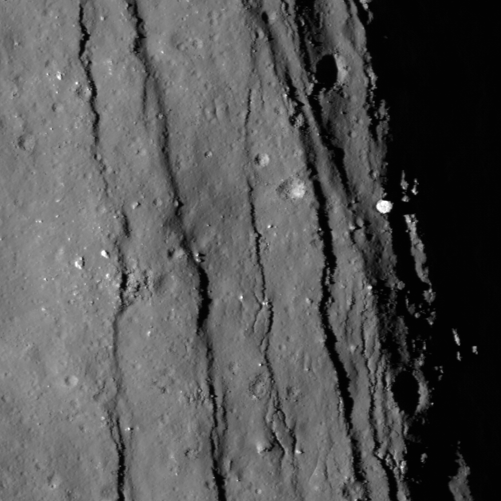
Schrödinger is an example of an intriguing type of basin called a peak-ring. Like the basin rim (brown outer ring), the smaller and more fragmented peak ring (brown inner ring) is a mountainous region of crust that rose up after a huge object, probably measuring 35-40 kilometers, or about 21-25 miles, smacked into the moon here. These areas of raised crust are the oldest rocks in the basin and just about the only material that wasn't melted by the heat from the object's impact. The melted material was spewed in all directions and formed the plains. Patches of plains material can have slightly different textures and albedo (indicated by dark green and kelly green), probably because they cooled at different times. Fractures (black lines) formed in the basin floor as the material cooled.


The Clementine image of the Schrödinger basin with geological map (2010). The three landing sites and corresponding 10 km EVA radius (20 km return trip) are outlined in white. The yellow numbers correspond to following scientific points of interest: 1 – Schrödinger’s melt sheet, 2 – Schrödinger’s inner ring, 3 – basaltic units, 4 – explosive volcanic unit, 5 – deep crustal fractures, 6 – ghost craters, 7 – secondary craters, 8 – ridged terrain. - From Kohout, O’Sullivan & Kring, et.al., Scientific Opportunities for Human Exploration of the Moon’s Schrödinger Basin [LPSC 2009 #1572] The Schrödinger Basin provides a diverse suite of scientific opportunities because of the superposition of several geologic processes and because of its relatively young age. Three possible landing sites were evaluated for human exploration.

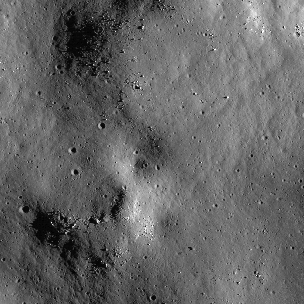
Schrödinger Basin is one of the few areas near the moon's south pole with evidence of recent volcanic activity. This includes lava flows from volcanic activity on the surface (beige areas) as well as explosive eruptions from a vent inside the red area; this vent has brought up dark material that mantles the plains (red area, which is newer than the beige regions). Older volcanic material is spread over a wider range (gray and lime green). More recent cratering by smaller objects has scattered material (yellow areas) near the top of the basin. Next to that (very light green beside yellow) is a region with a knobby texture that suggests loose material that could have come from cratering outside the basin or from a landslide on the basin's rim.

From July 16, 2010 -
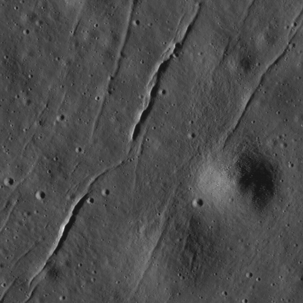
LOLA Image of the Week (since July 16, 2010) Schrödinger (centered -75.0˚, 132.4˚ E), "located on the lunar far side and within South Pole-Aitken Basin, is not visible from the Earth. Crater counts suggest that the basin is less than one billion years old, making it the second youngest impact basin on the Moon (the youngest being Orientale)."

From April 23, 2010 -
Mosaic of Clementine UVVIS images (750-nm band) of the Schrödinger Basin (312 km diameter). In addition to the prominent, dark, cone-shaped feature (white arrow), Schrödinger has an inner ring of mountains partially encircling the basin floor (a ‘peak ring complex’) and a network of radial and concentric fractures. The cone is a likely volcanic vent situated on a north- east trending floor fracture, and it has a 4.5 km x 8.6 km vent surrounded by dark, explosively emplaced or pyroclastic material and a low rim. The Schrödinger volcanic vent is one of the most distinctive single-vent cones observed on the Moon and resembles ‘dark halo craters’ like those on the floor of Alphonsus. (Projection is polar stereographic, centered on the basin at -75.0°S, 132.0°E) [NASA/DOD/USGS/ASU].

From April 23, 2010 -
LROC Narrow-Angle Camera (NAC) closeup of clustered craters on the lip of the Schrödinger pyroclastic cone, a Constellation Region of Interest (ROI). Although believed to be relatively young, these craters have a subdued appearance, a texture smoothed by micrometeor 'gardening' typical of older lunar surfaces) because they formed in loose pyroclastic material. LROC NAC Frame M108313384R, this view is 785 meters across [NASA/GSFC/Arizona State University].
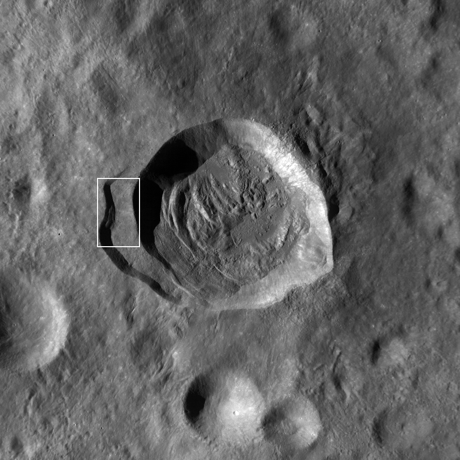
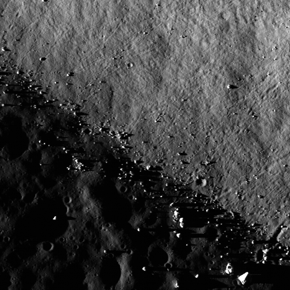
"A particularly interesting and unusual feature was imaged by Mini-SAR almost by accident. Because of a timing error, we started a few mapping passes of the south pole early, before the scheduled start at 80° south latitude. Good thing we did! We covered the fresh, spectacular Schrödinger impact basin, on the lunar far side. Schrödinger shows an unusual, keyhole-shaped crater along a long fissure on the basin floor. This crater is surrounded by optically dark material, which has been interpreted as volcanic ash deposits. The new Mini-SAR image shows that this material is also dark in radar reflectivity, exactly what would be expected from a fine-grained, block-free deposit. Thus, our radar images confirm the geological interpretation first derived in 1994 from Clementine images."

- Paul Spudis
Smithsonian Air & Space
March 29, 2009
From February 21, 2008 -
Kaguya (SELENE-1) multi-band imager (MI) compositional and morphological study of the Schrödinger pyroclastic formation (75.3°S, 139.1°E) [JAXA/SELENE].


Clementine (1994) and Kaguya (2008-2009). Ultra-Violet & Visible light (750-nm) UVVIS image of Schrödinger basin. b) Schrödinger DMD image taken by SELENE MI 750 nm band. c) MI 1000 nm/1050 nm absorption depth ratio from 0.8 to 1.2. From Kobayashi & Ohtake, et.al., Estimating Composition of Dark Mantle Deposit in Schrödinger Basin Using SELENE Spectral Data [LPSC 2009 #1636] Dark Mantle Deposit (DMD) regions are considered to contain glassy or crystallized pyroclastic beads. We used the spectrum data acquired by SELENE Multi-band Imager to analyze a DMD in Schrödinger basin, and estimated the composition of the DMD.

From April 23, 2010 -
Moving north (top) in a polar orbit, Japan's Kaguya took extensive HDTV of the lunar far side, including this still showing the Schrödinger Basin interior. The low and relatively darker profile of the pyroclastic dome encircling the vent is right (east) of the image center [JAXA/SELENE].

From August 31, 2010 -
Earlier Kaguya (SELENE-1) image of the eastern interior of 312 km-wide Schrödinger. The subtle differences in geologic compositions are visible, in this very-close to true-color view from 2008, though in late morning illumination the darker Schrödinger pyroclastic formation (upper center right) is an unmistakable contrast with its surroundings, in color and cratering. [JAXA/NHK/SELENE].

Finally, with sincere appreciation for all the tireless efforts underway keeping the LRO mission working and healthy, in the words of the LROC team, we urge you not to hesitate to "explore the Schrödinger Constellation region of interest for yourself!"

Necho's Terraces


Closeup view of the spectacular western terrace of Necho crater. LROC Narrow Angle Camera observation M134388215R, field of view is 660 meters; LRO orbit 4938, July 21, 2010 [NASA/GSFC/Arizona State University].

Brett Denevi
LROC News System

Necho is a Copernican Age 30-km complex crater in the far side highlands (5°S, 123°E). Necho displays beautiful terraced walls formed as a large section of the wall slumped into the crater interior shortly after the impact event.


Reduced resolution NAC mosaic of images M134388215L and R [NASA/GSFC/Arizona State University].

Terraces are typical for craters of this size, though in Necho's case the terraces formed only on the western side.


LROC Wide Angle Camera (WAC) monochrome image of Necho (30 km in diameter) showing the location of the NAC mosaic above. LROC WAC M119048299M [NASA/GSFC/Arizona State University].

What's causing this asymmetry?

It appears that Necho formed on the rim of an older, highly degraded crater. The western half of Necho formed rather normally but the eastern half was affected by this preexisting topography.

The walls on that side were lower, allowing huge flows of impact melt to spill from the crater as seen in the past Featured Image, July 29, 2010 (highlighted again in tomorrow's image.

Necho's serendipitous formation at this site resulted in an extra-beautiful lunar crater. Discover the beauty of Necho's terraces for yourself in the full LROC NAC mosaic.

Related posts: Necho Crater

Monday, August 30, 2010

Nobel Prize winner warns of helium scarcity


Probable distribution of helium-3 (3He) on the lunar surface is strongly linked to mare basalt with a high solar incidence and the presence of thorium and titanium oxide. Geologist Harrison Schmitt, Apollo 17 lunar module pilot, with Gerald Kulcinski of the University of Wisconsin at Madison, has long and urgently advocated a fusion-powered Helium-3 Economy by 2050. Though not all the more familiar near side lunar 'seas' show the high likelihood of ready reserves of helium-3, Schmitt notes one area likely to hold future economical reserves of this commodity are within Mare Tranquillitatis and under the landing site of Apollo 11.

Discover Blogs/80beats

The United States currently holds around half of the world’s helium supply and we’re selling it, for cheap.

We’ve known this for a while. We started stockpiling the stuff near Amarillo, Texas in 1925, in part for dirigible use, and stepped up reserves in the 1960s as a Cold War asset. In 1996, Congress passed the Helium Privatization Act mandating that the United States sell the gas at artificially low prices to get rid of the stockpile by 2015. This February, the National Research Council published a report estimating that, given increasing consumption, the world may run out of helium in 40 years. That’s bad news given helium’s current applications in science, technology, and party decorations–and possible future applications in fusion energy.

Now physicist Robert Richardson, who won a 1996 Nobel Prize for work using helium-3 to make superfluids, has come forward to stress the folly of underselling our supply of the natural resource. He suggested in several interviews that the gas’s price should mirror its actual demand and scarcity. He estimates that typical party balloons should cost $100 a pop.

“They couldn’t sell it fast enough and the world price for helium gas is ridiculously cheap,” Professor Richardson told a summer meeting of Nobel laureates…. “Once helium is released into the atmosphere in the form of party balloons or boiling helium it is lost to the Earth forever, lost to the Earth forever,” he emphasised. [The Independent]

Read the full review, HERE.

See also:
"Helium-3 powering the future?"
August 14, 2008

Google Lunar X-Prize teams progress


Omega Envoy’s spacecraft development lead engineer Dillon Sances (l) and Steve Murphy (r) their lunar lander’s base plate after being machined at Embry-Riddle Aeronautical University (ERAU). Dillon, a graduate student at ERAU, is developing test models of the vehicle he designed through a rapid prototyping process. Murphy is an ERAU undergraduate assisting in the design and developing a payload assist stage to put the Omega Envoy bus in lunar orbit prior to landing [Omega Envoy].


The Omega Envoy Project, competing for the Google Lunar X-Prize, spotlighted its proposed lander design, August 27. Most lunar rover mission designs incorporate a lander bus to ferry a rover to the lunar surface which afterward can serve as a range marker, telemetry translator and uplink [Omega Envoy].


Caterpillar, Inc. has joined in co-sponsoring Carnegie Mellon University (CMU) spin-off Astrobiotic Technology's bid for the Google Lunar X-Prize. CMU has already expended $3 million toward winning the competition. Astrobiotic lead David Gump's announcement may be read, HERE.

Saturday, August 28, 2010

Aldrin 'shares experience, strength and hope'

Buzz Aldrin, 80, whose autobiography "Return to Earth" following the first manned landing on the Moon in 1969 pioneered the removal of the public stigma once attached to alcoholism and depression, spoke about that struggle in Yakima, Washington, August 26 [Sara Gettys-Yakima-herald.com].


Ross Courtney
Yakima Herald-Republic

Buzz Aldrin applied the same patience and commitment he used to reach the moon to battle the depression he faced after returning.

The second man to walk on the moon was in Yakima on Thursday to give the keynote address at the 25th annual Merrill Scott Symposium on Alcoholism and Other Chemical Addictions.

Aldrin talked briefly with reporters in the lobby of the Hilton Garden Inn before speaking to about 450 people at the annual event, sponsored by the Sundown M Ranch chemical dependency treatment facility in Selah.

The 80-year-old former astronaut said he planned to share his personal story about the depression he suffered after returning from the historic 1969 moon landing with Neil Armstrong.

Aldrin said he struggled to cope with his sudden fame and lack of structure, after spending years in a meticulously structured environment during his astronaut training.

"The challenges that faced me were not going to the moon, but it was the aftermath of a tremendously changed lifestyle," he said.

Aldrin detailed many of his struggles -- which also included mental illness, alcoholism and a divorce -- in his 1973 book "Return to Earth."

Aldrin is one of the highest on a list of high-profile speakers to keynote the annual workshop, said Scott Munson, executive director of Sundown M Ranch.

Peter Yarrow of the folk trio Peter, Paul & Mary headlined last year. He, like many of the other speakers, related personal stories of addiction, Munson said.

With reporters Tuesday, Aldrin also shared a few strong opinions on the nation's current space endeavors.

He criticized plans to terminate the space shuttle program later this year with nothing to replace it, but does not believe the U.S. should send another man to the moon.

Read the full article, HERE.

Thursday, August 26, 2010

The Hummocks of Tsiolkovskiy

Updated August 27, 2010 1655 UT

LROC Narrow Angle Camera observation M115475912R shows the hummocky terrain north of the Central Peak of Tsiolkovskiy, well within the crater rim - though not a remnant of the slumping of collapsing crater wall material that resulted in the crater's magnificent terraces, but also outside the region flooded by mare basalt. The hummocks formed as the crater rebounded after the shock of impact dissipated. The image field of view is 940 meters, with an solar illumination incidence angle of 75° [NASA/GSFC/Arizona State University] - Sarah Braden, LROC News System, August 26, 2010.


The Featured Image (arrow) in a montage within 6000 (of 52224) lines from LROC NAC frames M114575923R & L, from half-way across the hummock formation to its boundary with Tsiolkovskiy's mare basalt fill. Channels through the hummocks, and even a solidified "falls" at the boundary shelf are seen. Study of the formation may reveal mixing, channeling and cooling behaviors of super-heated materials elsewhere on the Moon. The LRO frames, from 60.25 km (LRO orbit 2151, December 15, 2009) are superimposed on a low-resolution digital elevation model [NASA/GSFC/ASU/JAXA].


The Hummock region of the north central interior of Tsiolkovskiy from the Apollo 15 Service Module mapping camera in 1971. The arrows indicate the general location of the LROC featured image and the mare-Central Peak boundary, below [NASA/ASU/LPI].

More of Tsiolkovskiy's boulders and boundaries


The central peak of Tsiolkovskiy crater is surrounded with mare basalt. This Narrow Angle Camera frame shows where boulders have rolled down the sides of the steep central peak onto the Sea floor (boulder trails abound). The central peaks of larger lunar craters like Tsiolkovskiy are of particular interest because they expose rock uplifted from great depth, rebounding during the impact event. This image is 890 meters wide, with a sunset solar incidence angle of 88° [NASA/GSFC/Arizona State University].


Pulling back, to the full 4.25 km-wide field of view of the LROC observation, boulders abound, shedding from the peak. The LROC Featured Image further up is indicated by the arrow. LROC NAC M101313293LE was gathered very early in LRO mission, on July 4, 2009. Orbit 114 was still relatively eccentric when compared to the nearly circular 50 km Nominal Mission orbit where LRO presently operates. It's altitude above was 84.95 km, and the image resolution is about 90 cm per pixel [NASA/GSFC/Arizona State University].

Browse the full NAC image, from top to bottom, HERE, and it's companion half, HERE.


Five LRO NAC observations, representing widely varying illumination angles and altitudes, are seen here superimposed on Clementine (1994) albedo studies [NASA/GSFC/Arizona State University].


Even though far more bright highland terrain exists on the Moon than mare-inundated basins, you wouldn't know by looking at the near side from Earth alone. In the hemisphere centered on Tsiolkovskiy, none of the spectacular basins and other features we now know exist in this field of view stands out as clearly as this most obvious feature of the far side.


Now ready for LROC close-ups, Tsiolkovskiy, with rest of the far side, is tidally locked beyond line of sight from Earth. The Soviet Union's probe Luna 3 caught humanity's first photographic look in 1959. The surprising differences between the Moon's near and far sides, with an origin still being debated, was obvious even in these first photographs. The relatively small, heart-shaped Sea of Tsiolkovskiy, with it's lofty central peak, stood out clearly from the bright highland that surround it [RAS/USSR].

Wednesday, August 25, 2010

Small fractures in the mare floor of Tsiolkovskiy

Updated August 25, 2009 1500 UT

Small fractures in the mare floor of Tsiolkovskiy Crater are a departure from the usual scene of smooth mare pitted with impact craters. As the mare cools, fractures like these can form, or these fractures might have formed due to changes in the morphology of the Tsiolkovskiy impact crater over time. Image width is 580 m; NAC Image M130822373R, incidence angle 73° and resolution is 0.58 meters per pixel [NASA/GSFC/Arizona State University].

"The Earth is the cradle of the mind.
But one cannot live forever in a cradle."
- Tsiolkovskiy

Sarah Braden
LROC News System

Located on the lunar far-side (20.4° S, 129.1° E), the interior of Tsiolkovskiy Crater is filled with Upper Imbrium aged mare basalt. The 185 km diameter impact crater is named after the Russian physicist and space pioneer Konstantin E. Tsiolkovskiy (1857 - 1935). The first image of this crater was acquired by the Soviet Luna III robotic spacecraft in 1959.

Read more about Tsiolkovskiy crater here, view the LROC NAC Youtube movie, and browse the full-resolution NAC image, HERE.


Only a kilometer away from the area featured by LROC, similar fractures impinge through a small space weather and micrometeor worn crater. One trail of fractures clearly runs through the crater structure, clearly younger than both the crater and the surrounding terrain. It also appears to have caused generous shedding. Sampling of differing ages in similarly impinged features help date the faults and trace their origin. LROC NAC M130822373R, LRO orbit 4412, June 10, 2010 [NASA/GSFC/Arizona State University].


A five kilometer long section, 2.6 km-wide, from the Narrow Angle Camera observation shows the featured area, the impinged crater above (arrows), and at bottom the a sharp steep boundary between basalt inundated crater interior and the steep rise of Tsiolkovskiy's slumping rim. (see Kaguya HDTV still, below) LROC NAC M130822373R [NASA/GSFC/Arizona State University].

Related posts:

Hummocks and blocks and craters

Uplift, Boulders of Tsiolkovskiy

Floor of Tsiolkovskiy -
Constellation Region of Interest


HDTV view of Tsiolkovskiy from Japan's SELENE-1 (Kaguya) lunar orbiter in 2008 (compare with a Kaguya HDTV still from the crater's opposite side, HERE - May 1, 2010). The view here is from the north and above, showing the rugged terrace structure of wide slumping walls and an interior dominated by central peak. NASA, MIT and the Naval Research Laboratory hope to eventually deploy a radio telescope here to probe the elusive cosmic Dark Age, taking full advantage of radio quiet available only on the Moon's far side shaded from the loud interference of earthbound radio on needed frequencies [JAXA/NHK/SELENE].

Tuesday, August 24, 2010

The Moon: Creating capability in space and getting value for our money

Paul D. Spudis
The Once & Future Moon
Smithsonian Air & Space


Of all the possible destinations in space, the Moon offers the proximity, accessibility, and materials necessary to learn how to use what we find in space to create new capabilities. Harvesting the resources of the Moon will allow us to make what we need in space, rather than carrying it with us from the Earth’s surface. The model currently used to pursue our national interests in space – design-launch-use-discard – restrains opportunity, affordability and capability. We can break the limits imposed on all of these factors by learning how to use the resources of space. The development of the Moon creates an extensible, flexible transportation system that opens up the new frontier for many possibilities. Acquiring this essential space faring skill requires investment and commitment, with the full understanding of what will be achieved by this paradigm shift – the beginnings of a new space-based economy. What price tag would you put on that?

A constant refrain in policy discussions is that the space program is too expensive. This verity is at the core of the Augustine report, which asserts that Project Constellation (NASA’s Program of Record to implement the Vision for Space Exploration) is too expensive and requires at least an additional $3 billion per year to implement. The “New Space” community is aggressively campaigning for commercial launch services, pronouncing any NASA-designed/NASA-built space system politically “unsustainable” due to the agency’s inability to receive adequate funding from Congress over the lifetime of a flight program.

The civilian space agency’s 2010 budget is about $19 billion. That’s a nice chunk of change but compared to what the federal government spends elsewhere, it’s not a head-turning sum. For comparison, the Department of Energy’s nominal funding currently stands at $26 billion, to which Congress recently added an additional “one-time” $35 billion for the next two years, averaging out to about $43 billion per year – more than double what NASA will receive.

Other federal agencies and departments are funded at even higher levels. The Department of Education’s FY 2010 budget is $68 billion, of which $56 billion is “discretionary” (meaning non-entitlement). This handsome outlay is for an agency whose principal mission is to influence and monitor public schools; in fact, educating tomorrow’s citizens is the responsibility of state and local authorities and is covered by those taxes, which make up approximately half of the states’ budgets. So in federal spending terms, NASA does not consume as much as most people believe nor is it even “expensive” when stacked up against the cost of other agencies. And when managed even moderately well, we get something for our investment in NASA.

What drives space costs? Advanced technology alone is not the cause. An iPod contains more advanced systems than any single piece of electronic equipment carried 40 years ago on an Apollo spacecraft and is available for a couple hundred dollars. An array of electronic boxes in our homes offer 500 channels of high-definition video in surround-sound stereo – a stunning visual and aural sensory assault – for only a couple thousand dollars. The family automobile contains sensory and monitoring computers, protective airbags, fuel injectors, catalytic converters, automatic parallel parking systems, GPS, satellite radio, DVD players, and a slew of other innovations only dreamed of 20 years ago. These vehicles are affordable enough that most families have more than one in their driveway and buy new models on a regular basis.

Building and launching space vehicles is expensive but the reasons why might surprise you. It’s not the equipment or even the infrastructure that drives up costs. It may well cost hundreds of millions to billions of dollars to build a launch pad and its associated facilities, but once constructed and maintained, it is used essentially forever (some facilities at the Cape have launched rockets for over 50 years). The propellant used to hurl payloads into space makes up only about one percent of the cost of launch. Rockets are built of shaped aluminum (along with a few other more exotic metals) and those pieces make up an additional 10% or so of the total cost.

Spaceflight costs remain high because it requires complex machines, with millions of parts working together in a precise order and in perfect coordination to put a payload into space. To assure that these events transpire as planned, we pay a large number of highly skilled technicians, engineers and scientists to design, build and operate space systems. These high demand people don’t work for minimum wage. It requires almost 10,000 people to operate the U.S. Space Shuttle launch vehicle system. Everyone has a critical job, from program design to inspecting and replacing thermal tiles on the orbiter airframe, to stacking and configuring the vehicle for launch –- everything and everyone necessary for the construction, operation and flight of the vehicle to and from orbit. It is a specialized machine that is custom-made and individually operated. Moreover, each individual piece of hardware has a paperwork trail so that part failures can be tracked back in time and space. Documenting these part histories and pedigrees requires many hours, all billed to some charge code.

Despite our best efforts, rockets are finicky and unpredictable. Sometimes, satellites don’t wind up in the proper orbit or fail to operate correctly. Customers who paid for the satellite need some kind of indemnification against these possibilities. Insurance rates are based on a careful assessment and determination of risk. For a launch system with a long history of reliable performance, premiums are relatively low (but still substantial). New rockets and new companies face higher insurance costs and it may take many years to establish a track record of enough resiliency and consistency so as to significantly lower insurance rates. These costs must be folded into the cost per kilogram to LEO.

Which brings us to the inescapable fact that a major obstacle to routine affordable spaceflight –what makes other high technology efforts affordable – is the lack of mass production and automation in the fabrication of space systems. If we could mass produce rockets and automatically assemble and check them out for launch, launch costs would drop dramatically. Commercial items are inexpensive because development costs are amortized over very large sales volumes. For space systems, development costs are very large and not easily hidden by amortization.

A way to make spaceflight cheap is to remove much of the highly paid human talent from the end-to-end processing stream. One possibility is to automate most of the process of rocket fabrication, assembly, checkout and launch. A wholly new approach to our launch service infrastructure and model of operations would be required and to my knowledge, no company or government entity is working on such an approach. Even SpaceX uses a skilled cadre of people to custom build, launch and operate their vehicles. The claimed goal of SpaceX is a factor of ten reduction in cost and increase in reliability. I hope they reach it. But even if they do, space travel is still a costly enterprise; reduction of cost from the current $10,000 per kilogram (Atlas 5) to $5400 per kg (the quoted current cost for a Falcon 9 launch, which is not yet operational) is progress, but is not the canonical “hundreds of dollars per pound” breakthrough sought by space fans everywhere.

Another way to lower costs is to do what others in high-technology fields have done: outsource the work overseas. The Indian PSLV rocket can put 3700 kg into low Earth orbit and costs about $20 million (at least, that’s what informed sources claim it cost to launch TECSAR, an Israeli radar imaging satellite). This price works out to be about $5400 per kg, exactly the same as the projected cost for the Falcon 9 – and the PSLV already has a proven track record. The Russian Proton rocket puts about 20,000 kg into orbit for an estimated $115 million, about $5700 per kg. Even the supposedly “costly” European/French Ariane V puts 18,000 kg into space at a cost of $120 million, or about $6600 per kg.

The cost of all these competing systems seems to be approaching a single value – $5000 per kilogram is achievable for launch within the existing engineering state-of-the-art. Is such a cost “cheap enough?” Commercial launch costs have hovered between $5000 and $10,000 per kilogram (constant dollars) for the last thirty years. This “expensive” price structure has given rise to a thriving commercial space industry, especially in global communications. And despite the hype about orders-of-magnitude decreases in the cost of launch, these numbers likely will persist for the indefinite future. SpaceX has no access to special physics, ULA cannot repeal the law of gravity and XCOR cannot change the rocket equation.

Space launch costs what it costs. Spaceflight is expensive because we employ and pay thousands of highly skilled and trained people to build and operate space systems. Despite decades of planning and talking, these costs have not decreased significantly and the dream of cheap space launch remains a chimera. We frequently get marginal improvements in the dollars per kilogram number, but never of the order-of-magnitude variety. The problem of small volume/high cost cannot be solved by factors of two or three decreases in launch cost. We need a new operational approach that severs the Gordian Knot problem of the cost of space launch.

The use of off-planet resources of materials and energy is that approach. Despite new launch vehicles, new companies and supposed new approaches, we have only marginal improvements in the cost numbers for launch. It is time for the new and fundamentally different approach of developing the Moon’s natural resources to build a space faring infrastructure that will create new capabilities and give us lasting value for our money.

Paul D. Spudis is a Senior Staff Scientist at the Lunar and Planetary Institute in Houston, Texas.

Too brief an expedition to a lobate scarp

Lee Lincoln Scarp – the only lobate scarp toured on foot surveyed from the Lunar Reconnaissance Orbiter (LRO), February 1, 2010. Roughly sketched is the path of Cernan & Schmitt (Apollo 17) during rushed visit (EVA 2) to Taurus-Littrow in December 1972. White dotted lines mirror the two elevation studies discussed by Smithsonian investigator Thomas Watters, August 19. (One sampling apparently intersects the path of EVA 2 on their way to Geology Station 3, Ballet crater, east of Lara.) The blue arrows note, again roughly, the directions of mission photographs discussed below. Mosaic from LROC Narrow Angle Camera (NAC) observations M119652859L & R; north is at top, from 42.73 km alt., resolution 0.51 meters per pixel, and illumination from the west by southwest (phase angle 37.76°) [NASA/GSFC/Arizona State University/Smithsonian].

Joel Raupe

In reviewing reports of “The Incredible Shrinking Moon,” the headline originated by Paul D. Spudis and afterward headlining news accounts seemingly everywhere (including here, until we changed it to the less poetic "Moon geologically active, cooling, shrinking") we were inspired to spend time this past weekend re-experiencing the second EVA of Apollo 17.

Of all the known or newly-discovered thrust faults, manifested at the surface of the Moon by lobate scarpes, surveyed by Thomas Watters, senior scientist for the Center for Earth and Planetary Studies at the Smithsonian, cited as evidence that the Moon had "radially contracted," by 100 meters or so, and more recently than generally believed possible, only one has been toured and directly sampled.

The Lee Lincoln scarp, as labeled on maps, was walked on and driven over by Apollo 17 cmdr. Capt. Gene Cernan (USN, Ret.) and geologist Dr. Harrison H. Schmitt, on the night of December 12-13, 1972. It was next to last time anyone walked on the Moon.

Like every deep space survey, even virtual journeys like ours, we found more than we planned, and little of that immediately related to the formation of these tectonic features.

Montage of four 500mm photographs by Captain Cernan, from Geology Station 3 (Ballet crater, east of Lara), and likely our only view along a length of any lunar lobate scarp. (See the full-sized montage at the Apollo Surface Journal, HERE.) This is a foreshortened view of the scarp where it overlaps an intersection of the valley floor, the steep slope of North Massif. The feature winds upward, immediately bend to the north and northwest, like a mountain road bed, highly visible from a great distance. The movement of the thrust fault seems to have encountered the Massif and, meeting resistance, crept more slowly. The field of view is includes an area ranging from four to more than seven kilometers away. At lower center-right, Hanover crater peaks over an intervening lip of the scarp, like a Cyclops gazing over the valley floor [NASA/Apollo Surface Journal].

Some recent, hopefully temporary, computer problems continue to hamper our ability to expand graphically in as robust a manner as we prefer on the latest additions to this digest of Moon news. We're essentially bound to one audio and video format, for the moment. So we were somewhat astounded to find that the audio and video clips sequentially linked to the Apollo Surface Journal pages devoted to EVA 2 of Apollo 17 included those in that same format. Oddly, this was the true of the history of that EVA only.

We took the time to download and stack all these EVA 2 audio and television clips and then played these back to back without interruption. The result was highly worthwhile, underscoring how correct, but highly understated we are when we say "we've barely scratched the surface" of the Moon.


"The boys in the backroom" in Houston had already shaved the EVA timeline to add fifteen minutes to the their earlier stay at Nansen, on the slopes of South Massif, and were hustling Cernan & Schmitt along, by the time they arrived at the rim of Shorty crater. Their traverse of the northwestern interior of Taurus Littrow was nearly at an end. Meanwhile, Dr. Schmitt's earlier excitement was dragging slightly, but picked up instantly when his geologists' eye happened upon one of the most important discoveries of the Apollo era, "orange soil," in a landscape dominated by three shades of gray-brown dust. It took ground controllers only moments to catch up with his understanding of the possible significance of the discovery, and time was added for a longer stay. Across the horizon, with the Western Family Mountains and Mare Serenitatis beyond, is a band of lighter material. This is the edge of the lobate scarp, which is more than two kilometers away, and much better experienced in high resolution, HERE) [NASA/Apollo Surface Journal].

Others will come away from such an experience with different impressions, of course. That’s a subject for another post, but we were strongly reminded that as much time has passed since the Apollo 17 expedition and today than previously passed between the invention of talking motion pictures and the Apollo era.

Remotely operated, micro color television of rudimentary fidelity can be understood and excused. Allowing so much time to pass before advancing that experiment and others on the lunar surface cannot be.

Watching EVA 2. in “real-time,” also underscored the ironic brevity of the whole thing. The Apollo surface mission, particularly the last three Science, or "J" missions, were high water marks of civilization, culminating a decade-long devotion by 100,000 people. As we watched Gene Cernan and Jack Schmitt scramble through their perishable consumables, precious time and air, to get to the actual geology or their mission, with so many voices chattering and cautioning, and also hustling them along, we simply wondered that they were able to accomplish what they did.

Captain Cernan credits training, years of preparation, for the safe productivity of their expedition. These last missions to the Moon, especially this very last one, were also successful because of the full body of training and, by then, the experience of everyone involved.


The orange soil discovered and trenched out by Dr. Schmitt was found on the rim of Shorty, and slumped down the inner walls of the crater, most likely excavated from the depths hollowed out by the impact event. The crater itself, and the surrounding terrain now appear to have been pushed up by the thrust faulting, manifested by the scarp. In turn, Shorty sits within a wisp of the Light Mantle, higher albedo dusting the crew had come to sample. Those samples would add evidence to Schmitt's earlier determination of the age of Tycho, which appeared to have blown debris over the heights of South Massif and down into Taurus Littrow 109 million years ago. High resolution image, HERE [NASA/Apollo Surface Journal].

"Oh, hey!" Schmitt pauses very briefly, in the transcript by Eric Jones. They have just arrived at Station 4. By his own admission, Dr. Schmitt was tired, and it can be heard in his voice. right up until something caught his eye after describing the "very intensely fractured rock, right on the rim (of Shorty crater)."

Schmitt has just seen the orange soil, but He's cautious, Jones writes, having been fooled by the play of sunlight when he and Cernan were back on the scarp.

"Wait a minute...," Schmitt said. "Where are the reflections? I've been fooled once. There is orange soil!"
Reluctantly, the almost tyrannical voices from the Back Room, heard by the CapCom in Houston agree to add time to their stay at Shorty crater. Already, they had added time to their first stay at Nansen, by shaving time from their planned stay on the scarp and here at Shorty. It took only a minute or so for them to catch up with Schmitt, and by now Cernan, in understanding the possible significance of the find.

These finest particulate samples were later explained as evidence of fire fountains, perhaps similar to those seen in Iceland recently, occurring late in the Moon's cooling, perhaps now better understood as having been elevated nearer to the surface by the thrust fault which raised the whole vicinity explored during the EVA near the scarp, eventually excavated to the crater rim by the Shorty "impact event."

Those orange glass particles proved rich in titanium, iron oxide and also zinc. It was tantalizing evidence of the greater unknown part of the Moon, lying about just out of reach, or just beneath its surface. Just as the slow changing landscape of Antarctica allows for the discovery of lunar and martian samples, it's inevitable very unique terrestrial samples will be found on the Moon.

We were reminded, once again, that no comprehensive understanding of Earth can happen before a proper exploration of the Moon.

Happening upon the orange soil was a lasting result of Apollo 17, though the greater impression, we agreed, begged a simple question: If this is an example of what can be found during an abbreviated, rushed geology "field trip" on the Moon what might a true geology Season there discover?


Offering some perspective on the Shorty experience, Cernan panned through this high resolution image over and behind the crater, allowing an excellent look at it's interior, slightly stained with orange fallout. Over the far rim, thousands of meters further away, is the bend at the contact of scarp with the valley floor and North Massif slope, gazed over by of Hanover. (A strongly recommended high resolution view is HERE.) Compare with the vertical view below, and, in context, with the montage at the beginning of this post showing the vicinity from 40 km overhead (37 years later) [NASA/Apollo Surface Journal].


Shorty, in this stretched 196 meter wide scene sampled from LROC NAC observation M119652859R, swept up February 1, 2010. Those darker markings at lower left are foot prints and tire tracks. The outcrop and trench in the views further above are poised on the crater rim nearby. Illumination is from the west by southwest, or late afternoon. Cernan & Schmitt made their all-too-brief, but historic, visit at mid-morning [NASA/GSFC/Arizona State University].

Monday, August 23, 2010

Rocketdyne-Lunar Ascent Engine


Scale model of the Apollo lunar module ascent stage engine, by an important small company. The story of this vital and non-redundant system, built by a subcontractor, illustrates how a project within a project can sometimes be made to work [Pratt and Whitney Rocketdyne].

Tim Harmon
Chapter 7, Remembering the Giants

First time, everytime, there was no second chance. The lives of two men on another planet hung on the flawless performance of a single engine. Frames by Kipp Teague from the video [Apollo Surface Journal].

Redundancy was really a major hallmark of the Apollo Program. Everything was redundant.

Once you got the rocket going, you could even lose one of the big F-1 engines, and it would still make it to orbit. And once the first stage separated from the rest of the vehicle, the second stage could do without an engine and still make a mission. This redundancy was demonstrated when an early Apollo launch shut down a J-2 second-stage engine. Actually, they shut down two J-2 engines on that flight. Even the third stage, with its single J-2 engine, was backed up because the first two stages could toss it into a recoverable orbit. If the third stage didn’t work, you were circling the earth, and you had time to recover the command module and crew.

Remember how on the Apollo 13 flight, there was sufficient system redundancy even when we lost the service module. That was a magnificent effort. TRW Inc. really ought to be proud of their engine for that.

We had planned for redundancy; we had landed on the moon. However, weight restrictions in the architecture said, “You can’t have redundancy for ascent from the moon. You’ve got one engine. It’s got to work. There is no second chance. If that ascent engine doesn’t work, you’re stuck there.” It would not have looked good for NASA. It wouldn’t have looked good for the country. There was a letter written that President Richard Nixon would read if the astronauts got stuck on the moon, expressing how sorry we were and so forth. It was a scary letter, really. The ascent engine was an engine that had to work.

Read the full presentation (pdf, 4 Mb), HERE.

Thursday, August 19, 2010

Moon geologically active, cooling and shrinking

Updated August 23, 2010 22:52 UT

Lunar Tectonism. LROC digital terrain model (DTM) of the Lee Lincoln lobate scarp, running through the Taurus Littrow valley's northern interior, northwest of the Apollo 17 landing site. (The face of the scarp can be seen in this website's logo at the top of this page. -Apollo 17 lunar module pilot Harrison H. Schmitt examines the orange glass deposit on the western rim of Shorty crater, and the bright wall running across the scene behind him is the direct face of the scarp's down-slope) [NASA/GSFC/ASU].


Corollary profiles to the above cross-sections A and B, showing the rapid change in elevation across Lee Lincoln scarp [NASA/GSFC/Arizona State University].

Joel Raupe

Investigators have discovered compelling evidence the Moon may still be geologically active.

A newly discovered global distribution of very young upthrust faults known as lobate scarps indicate the Moon has shrunk, demonstrating a radial contraction by 100 meters over a period well within the past 800 million years. The discovery definitively sets aside previously long-settled notions that the Moon is geologically dead. Instead, the Moon has been cooling very recently, and may cooling still.

The discovery announced by NASA comes after careful examination of Lunar Reconnaissance Orbiter (LROC) Narrow Angle Camera observations and the discovery of newly-identified upthrust faults and mapping their global distribution together with similar already known features.

The nature and distribution of crater counts overlapping and below these upthrust faults shows them to be relatively recent phenomena, forming as the Moon continued (or continues) to cool far later than previously believed possible.

Thomas Watters, senior scientist for the Center for Earth and Planetary Studies at the Smithsonian National Air and Space Museum, revealed these findings ahead of their publication in the Journal Science, during a NASA teleconference, Thursday, August 19.


Newly Discovered lobate scarps Rozhdestvenskiy 1 (above) and Shoemaker (below), are examples of high lattitude, thrust faults. "Seven of the fourteen newly detected lunar scarps are found at high latitudes (> ±60°). The distribution of newly detected and previously known scarps suggests that thrust faults are globally distributed; important implications for the thermal history of the Moon." - Mark Robinson, LROC principal investigator, Arizona State University [NASA/GSFC/ASU].


"Contrary to what many people, including many scientists, believe," Watters told reporters, "the Moon is not a dead, inactive planet. The Moon is truly a dynamic planet."

"This is only the beginning of our understanding of this phenomena," added John Keller, LRO deputy project scientist at NASA Goddard Space Flight Center. "As with all missions, we set off with LRO and a well-mapped plan on what to do at the Moon. Now, however, we have added another unexpected paradigm change, and something new to look for.

"It is compelling evidence of a geological process taking place over a very recent time, and one that is perhaps still under way."

The global distribution and prevalence of lobate scarps was also discussed the National Lunar Science Institute's 3rd annual conference in July, as part of the presentation of a summary of Lunar Reconnaissance Orbiter Camera (LROC) discoveries during the past year, by LROC principal investigator Mark Robinson. Robinson's presentation slides can be reviewed (PDF), HERE.


Figure 1: Thrust faults are formed when the lunar crust is pushed together, breaking the near-surface materials. The result is a steep slope on the surface called a scarp as shown in this diagram [Arizona State University]. › Larger image


Figure 2: The mare basalts that fill the Taurus-Littrow valley were thrust up by contractional forces to form the Lee-Lincoln fault scarp It is the only extraterrestrial fault scarp to be explored by humans. The digital terrain model derived from Lunar Reconnaissance Orbiter Camera (LROC) stereo images shows the fault extending upslope into North Massif were highlands material are also thrust up. The fault cuts upslope and abruptly changes orientation and cuts along slope, forming a narrow bench. LROC images show boulders shed from North Massif that have rolled downhill and collected on the bench [NASA/Goddard/Arizona State University/Smithsonian]. › Larger image


Figure 3: Over recent geologic time, as the lunar interior cooled and contracted the entire moon shrank by about 100 m. As a result its brittle crust ruptured and thrust faults (compression) formed distinctive landforms known as lobate scarps. In a particularly dramatic example, a thrust fault pushed crustal materials (arrows) up the side of the farside impact crater named Gregory (2.1°N, 128.1°E). By mapping the distribution and determining the size of all lobate scarps, the tectonic and thermal history of the moon can be reconstructed over the past billion years [NASA/Goddard/Arizona State University/Smithsonian]. › Larger image


Figure 4: This map illustrates the distribution of lobate scarp features located thus far. Black dots indicate previously known scarps while white dots depict newly detected scarps found in images from the Lunar Reconnaissance Orbiter Camera [NASA/Arizona State University/Smithsonian]. › Larger image


Figure 5: Another fault cut across and deformed several small diameter (~40-m diameter) impact craters (arrows) on the flanks of Mandel’shtam crater (6.5°N, 161°E). The fault carried near-surface crustal materials up and over the craters, burying parts of their floors and rims. About half of the rim and floor of a 20 m-in-diameter crater shown in the box has been lost. Since small craters only have a limited lifetime before they are destroyed by newer impacts, their deformation by the fault shows the fault to be relatively young [NASA/Goddard/Arizona State University/Smithsonian]. › Larger image

America's Lunar Reconnaissance Orbiter (LRO) was launched from Kennedy Space Center, June 18, 2009 and commenced it's Nominal Mission phase the following September. Since then LRO has orbited the Moon 5,300 times and will soon have returned more data to Earth than all previous (and on-going) Deep Space missions, combined. Though investigators will sift through this treasure for decades to come, LRO has already become a central player in a revolution in our understanding of Earth's nearest neighbor in Space.

Searching for Alaska's lost lunar treasure

Elizabeth Riker
Capital City Weekly
Juneau


On May 25, 1961, President John F. Kennedy challenged the United States space program to safely send an American to the moon by the end of the decade. NASA met this challenge, accomplishing the President's goal by launching Apollo 11. The Eagle lunar module landed on the moon July 20, 1969. Part of this mission included collecting lunar samples from the moon to bring back to Earth.

NASA prepared the moon rocks for presentation to all 50 states and 135 countries around the world by the Nixon Administration. Alaska received its very own Apollo 11 Moon Rock, which in reality is four lunar fragments displayed in a Lucite ball, yet priceless to collectors. So how did Alaska treat its treasure from space? It is currently lost, misplaced, or has been stolen. State government officials are clueless to the whereabouts of this priceless treasure and Alaska's law enforcement is doing nothing to find its moon rock that may command 5 million dollars on the black market. Sadly, America's biggest state has made a blunder proportionate to its size.

My professor, a retired NASA Office of Inspector General Senior Special Agent, assigns his students the task of investigating unaccounted-for moon rocks that were given to the states and nations of the world. This assignment is called the "Moon Rock Project." I was assigned the Alaskan Apollo 11 Moon Rock to investigate and I have been pursuing it for five weeks.

Throughout this investigation, I have encountered people who have never heard of the Apollo 11 Goodwill Moon Rock and do not understand its significance and value. However, I have been in contact with others who are intrigued and have offered their assistance in the search. In particular, Steve Henrikson, Curator of Collections at the Alaska State Museum, is working diligently on this investigation. He contacted other museums in Alaska, urging them to search through their records to see if there is any sign of the moon rock display. Henrikson also contacted local government officials, who have no recollection of the moon rock; some are not even aware of the moon rock or its value.

Tatyana Stepanova, an archivist from the Alaska State Archives, provided evidence dating back to October 9, 1970. This evidence proves the moon rock display was presented to Alaska and was lent out to various individuals to be displayed throughout the state. The last location on record where the Moon Rock was to be displayed is the Chugiak Gem and Mineral Society in Anchorage, scheduled to be shown from February 12, 1971 through February 24, 1971. There is no evidence of the moon rock display's location beyond this date.

Tatyana Stepanova, an archivist from the Alaska State Archives, provided evidence dating back to October 9, 1970. This evidence proves the moon rock display was presented to Alaska and was lent out to various individuals to be displayed throughout the state. The last location on record where the Moon Rock was to be displayed is the Chugiak Gem and Mineral Society in Anchorage, scheduled to be shown from February 12, 1971 through February 24, 1971.

There is no evidence of the moon rock display's location beyond this date.

The fact of the matter is this moon rock was a gift from the Nixon Administration to the state of Alaska. It was meant to be shared with the people. An artifact of this nature represents an important accomplishment of our space program, and I am committed to seeing this investigation through. With help from the good citizens of Alaska, I am confident we will be successful.

Elizabeth Riker is a criminal justice graduate student and member of the "Moon Rock Project" at the University of Phoenix. She may be reached at ecriker@att.net.

Tuesday, August 17, 2010

NASA update: ILN Anchor Nodes and Robotic Lunar Lander Project

Updated August 18, 2010 1648 UT
Global Lunar Conference, Beijing
May 31- June 3, 2010

Exploration configuration. Refinements continue on designs for NASA's multipurpose lunar lander bus, while a timetable for deploying an unknown number of Anchor Nodes for the International Lunar Network (ILN) and the fate of a recommended Lunar Polar Volatiles exploration mission to the lunar surface remain on hold, awaiting hints of what will appear in the next Planetary Science Decadal Survey (2013-2022), expected in January 2011 [NASA/MSFC].

Brian J. Morse, Cheryl L. B. Reed
& Karen W. Kirby
Johns Hopkins, Applied Physics Lab

Barbara A. Cohen, Julie A. Bassler, Danny W. Harris
& D. Gregory Chavers
NASA Marshall Space Flight Center

ABSTRACT: In early 2008, NASA established the Lunar Quest Program, a new lunar science research program within NASA’s Science Mission Directorate. The program included the establishment of the anchor nodes of the International Lunar Network (ILN), a network of lunar science stations envisioned to be emplaced by multiple nations. This paper describes the current status of the ILN Anchor Nodes mission development and the lander risk-reduction design, and test activities implemented jointly by NASA’s Marshall Space Flight Center and The Johns Hopkins University Applied Physics Laboratory. The lunar lander concepts developed by this team are applicable to multiple science missions, and this paper will describe a mission combining the functionality of an ILN node with an investigation of lunar polar volatiles.

INTRODUCTION:

NASA Robotic Lunar Lander development. One of the defining features of the U.S. Vision for Space Exploration, established by the former administration and studied by NASA for the past 4 years, is the goal of a human return to the Moon to live and work for extended periods. Whether that plan will be executed, however, has grown increasingly uncertain. Turbulent economic times, along with the need for the new administration to set its own priorities, have resulted in a complete review of U.S. space policy and NASA’s programs.

Many months remain before the process will be complete and new plans can be developed. But even in the face of this uncertainty, it is clear that the Moon is of significant scientific importance to NASA and many other nations and is a prime target for low-cost robotic missions that can be undertaken by most of the world’s space programs. Thus, it can be expected that lunar robotic missions will remain a high priority while the U.S. human exploration program is restructured; when humans begin to venture beyond low-Earth orbit to the Moon, near-Earth objects, and eventually Mars, the generic technological capabilities developed through lunar robotic missions will serve as important steps toward future achievements. The Moon contains a wealth of scientific information about planetary formation and the origins of Earth.

NASA has a rich portfolio of lunar flight projects, including two payloads on India’s Chandrayaan-1; the Lunar Reconnaissance Orbiter (LRO); the Lunar CRater Observation and Sensing Satellite (LCROSS); the Gravity Recovery and Interior Laboratory (GRAIL); the Acceleration, Reconnection, Turbulence and Electrodynamics of Moon’s Interaction with the Sun (ARTEMIS) mission; and the Lunar Atmosphere and Dust Environment Explorer (LADEE) mission.

Other nations, including China, Japan, and India, also have emergent lunar portfolios. During this exciting time for lunar science, many significant scientific discoveries are just being realized from these flights, including the likely orbital confirmation of trapped water-ice on the lunar surface.

In addition, the U.S. National Research Council (NRC) is in the early stages of its new Decadal Survey for Planetary Science, which establishes priorities to be incorporated into the roadmap for NASA’s Planetary Division of the Science Mission Directorate (SMD).

The final report will not be ready until January 2011, but the results of many current planetary studies will be publicized along the way, previewing expected planetary (and lunar) priorities for the next 10 years. Internationally, multiple space-faring nations are concurrently planning robotic missions to the Moon. To maximize the scientific return of these efforts, nine national space agencies signed a statement of intent to establish a set of robotic lunar landers in a geophysical network on the surface of the Moon.

This collaborative initiative is known as the International Lunar Network (ILN). ILN nodes will fly a core set of instruments, plus additional passive, active, in situ resource utilization (ISRU), or engineering experiments, as desired by each space agency. Participants’ contributions can be landers, orbiters, instrumentation, or other significant infrastructure contributions, including communications capabilities, which in total will comprise the ILN.

From Lunar Pioneer Album 2 --
Anchor node of the International Lunar Network (ILN), hosted by the multi-use lander, now well along in development. The new generation configuration is shown here in an unlikely spot, if ILN ultimately turns out to be a sparse seismographic network (i.e., south central Mare Imbrium, in sight of Mons La Hire) [NASA/MSFC/JHU-APL].

The envisioned U.S. contribution to the ILN was the Anchor Nodes mission to be implemented jointly by NASA’s Marshall Space Flight Center (MSFC) and The Johns Hopkins University Applied Physics Laboratory (JHU/APL).

The ILN Anchor Nodes mission would develop a broad lander capability and establish surface and embedded elements to better characterize the structure and composition of the lunar interior. The United States originally envisioned launching the first two nodes to the mid-latitude regions in the 2015–2016 time frame, with an option to launch two more nodes shortly thereafter.

Alternatively, NASA could launch all four nodes in the 2017–2018 time frame. However, the specific science to be conducted, and the payload suite to carry out these measurements, could change, given the recently published lunar water-ice discoveries and the forthcoming results of the Decadal Survey. Discussions continue with NASA’s international partners to provide additional nodes within this time frame to constitute the first lunar scientific network.

Regardless of the specific science objectives, the goals of the Anchor Nodes mission will remain technically and programmatically challenging. These goals include the placement of multiple nodes on the near side of the Moon, continuous operations through many years of lunar eclipse, low-mass and low-power subsystems and instruments, and a minimum 6-year lifetime. Future nodes are planned for the far side of the Moon, for which lunar–Earth communication and navigation solutions are under consideration by countries supporting the ILN.

From Lunar Pioneer Album 1 --
In September 2009, Marshall Space Flight Center in Huntsville, Alabama announced the beginning of tests of a new robotic lunar lander test bed to aid development of a new generation of multi-use landers for robotic space exploration. The Phase One Cold Gas Test Article is equipped with thrusters to guide the lander, one set to control the vehicle's attitude, altitude and landing and additional thrust to offset the effect Earth’s gravity to simulate a lunar environment. By June 2010, the CGTA has been put through its paces 150 times [NASA/MSFC].

After the completion of an extended pre-Phase A study, the implementation of an ILN Anchor Nodes mission was placed on hold pending the resolution of the above-mentioned uncertainties. The MSFC–JHU/APL team was renamed the Robotic Lunar Lander Development Project (RLLDP) with the scope to complete an array of lander technology risk-reduction tasks and to perform studies on other missions that address some of the key science and exploration priorities.

One such mission combined the functionality of a single ILN node with instruments to prospect for volatiles in a fixed location within a permanently shadowed lunar polar crater. The latest data from lunar orbiting observatories have further fueled interest in attaining “ground truth” for the presence of volatiles, including water-ice, in permanently shadowed craters.

The single-site approach is limited in its ability to fully satisfy key science goals associated either with the ILN mission or with a desire to fully characterize the volatile distribution, but it represents a much more affordable single mission that, combined with other missions, could more fully address these goals. The results of this study and the status of the risk-reduction tasks spanning technologies in propulsion; guidance, navigation, and control; power; avionics; thermal; and structures and mechanisms are documented in this paper.

SCIENCE. The Moon provides an important window into the early history of the Earth, containing information about planetary composition, magmatic evolution, surface bombardment, and exposure to the space environment.

Despite more than 4 decades of intensive study, many aspects of the Moon remain to be determined. One of the key motivations for studying the Moon is to better understand the origin of the planets of the inner solar system in general and that of Earth in particular.

The NRC report, New Frontiers in the Solar System: An Integrated Exploration Strategy (the Planetary Science Decadal Survey), is the principal roadmap for solar system exploration, providing a community-based weighting of science priorities across the solar system, including the Earth’s Moon. In this document, the Inner Planets Panel asserted that the inner solar system affords the opportunity to address broad objectives for understanding the history, current state, and potential future of habitable planets. Landed missions were recommended by the panel for all of the terrestrial planets—Mars, Venus, Mercury, and the Moon—in order to address multiple key aspects of inner solar system science.

The next Planetary Science Decadal Survey for the period 2013–2023 is currently under way. This report will not be ready until January 2011, but the results of many current planetary studies will be publicized along the way, previewing expected planetary (and lunar) priorities for the next 10 years.

In support of this activity, the lunar science community articulated and prioritized its science objectives in a set of 35 white papers, painting a coherent and compelling picture of the importance of lunar science to understanding differentiation of planets, the bombardment history of the inner solar system, and processes unique to airless bodies. Two candidate lunar lander missions—a geophysical network and an in situ polar volatile explorer—were studied and presented to the Decadal Survey by this team in order to address multiple key aspects of lunar and planetary science.

Lander technology developed for any of these missions will have significant feedforward to other missions to the Moon and indeed, to other airless bodies such as Mercury, asteroids, and Europa, to which many of the same science objectives are applicable.

Read the Report and Presentations (pdf), HERE.

From Lunar Pioneer Album 3 --
Warm Gas Test Article, currently slated for testing at Marshall Space Flight Center, takes the multi-use lander design testing beyond the maneuver, attitude control and landing thrust demonstrated using the Cold Gas Test Article began in 2009. Testing can now begin for critical maneuvers like Terminal Descent [NASA/MSFC].

Related:
Robot Landers for Science & Exploration
Chavers & Cohen, et.al. [JHU-APL/MSFC]
7th International Planetary Probe Workshop (IPPW-7)
Barcelona, June 12-18, 2010