Thursday, May 31, 2012

LROC: A Beautiful Impact on the rim of Lomonosov

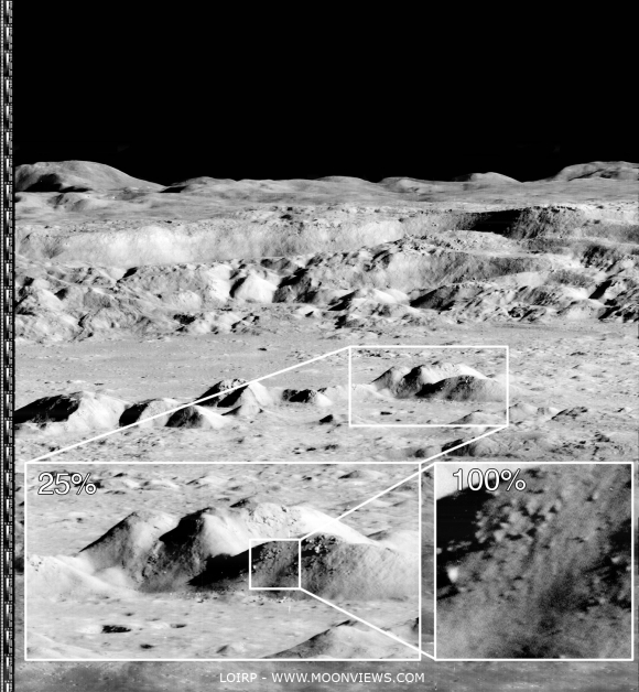
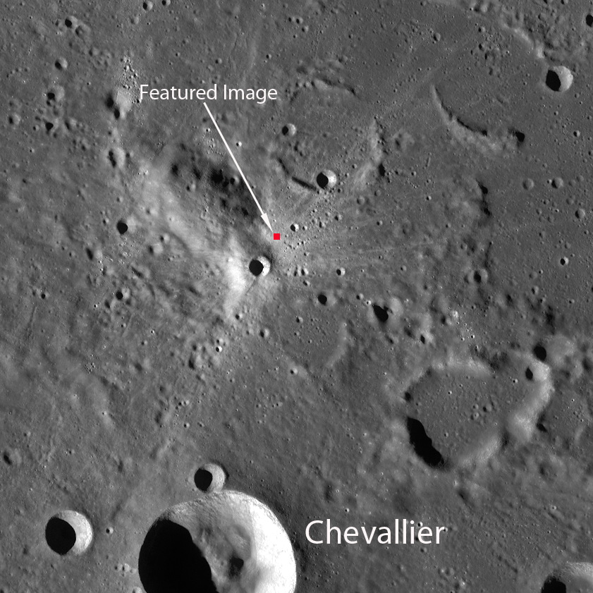
Young impact craters often present a striking array of tones in their ejecta. Illumination is from the southeast, image is ~500 m across, LROC Narrow Angle Camera (NAC) observation M156964572L, LRO orbit 8266, April 9, 2011; resolution 0.55 meter over an incidence angle of 29.68° from 53.1 kilometers. View the larger LROC Featured Image HERE [NASA/GSFC/Arizona State University].
James Ashley
LROC News System

Yesterday's Featured Image post focused on regolith of contrasting reflectivity within the ejecta blanket of a 3 kilometer in diameter lunar impact crater.

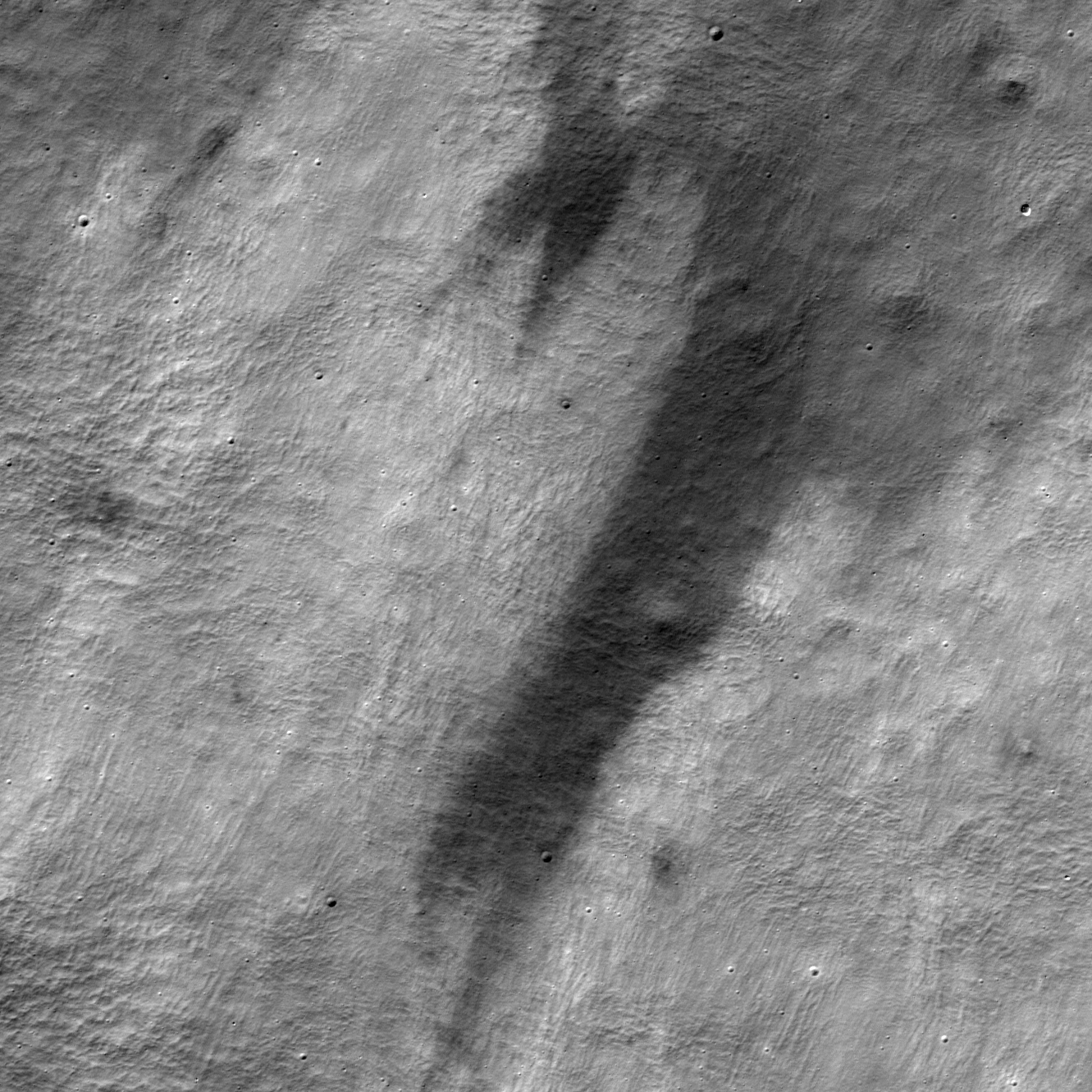
Today's post shows another example of recently disturbed lunar regolith, but associated with a crater only 80 meters in diameter.

Impacts from space debris occur randomly across the lunar surface, and the target for this event just happened to be a fault slump along the high western wall of Lomonosov crater in the farside highlands.

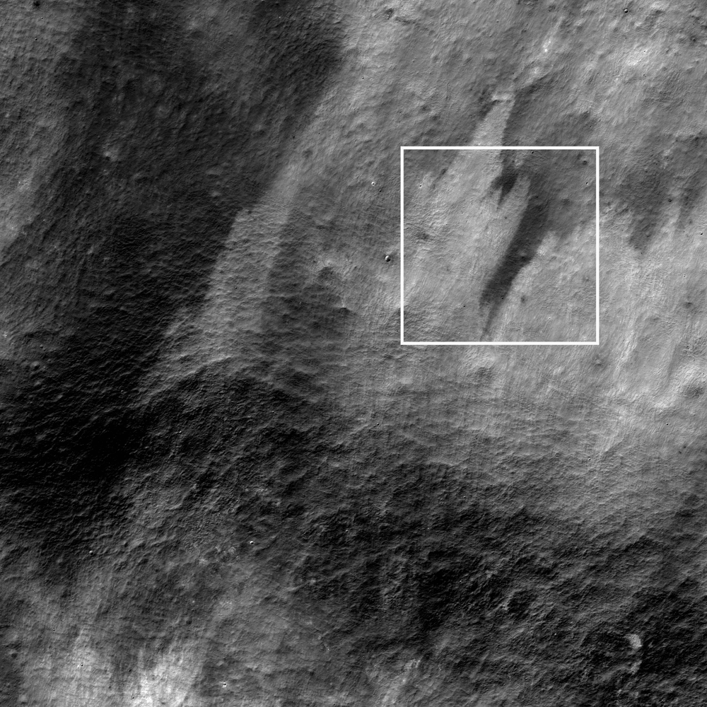
The white square shows the Featured Image location within a larger context portion of LROC NAC frame M156964572L. Image is ~2.4 km across. [NASA/GSFC/Arizona State University].

Once again we see space-weathered, low-albedo deposits mixing with fresher ("optically immature") materials of higher albedo excavated from beneath the surface layer.

Because of space weathering the Moon is actually a relatively dark object in the solar system. Its overall low reflectance is not apparent to the human eye when seeing the Moon from Earth at night because the Moon is in direct sunlight against the inky black background of Space. In spacecraft images showing the Earth-Moon system (properly exposed as a pair) the low albedo of the Moon becomes obvious.

The WAC mosaic shows the field of view in the LROC Featured Image released May 31, 2012 high on the west rim of Lomonosov (arrow), almost two kilometers higher in elevation relative to the Moon's global mean than the mare inundated floor of the 108 kilometer wide crater. The simulated view juxtaposes the LROC Wide Angle Camera (WAC) 100 meter Global Mosaic imagery with LOLA laser altimetry using the ILIADS application from NASA's Lunar Mapping and Modeling Project (LMMP) -  simulated view from 45 km over the Moon south-southwest of Lomonosov  [NASA/GSFC/Arizona State University].
Lomonosov may be a highland crater, but its floor more closely resembles a mare deposit, being composed of a smooth lava plain. Compare Lomonosov with Plato crater in the 29 May 2012 post. Some of the brighter patches of material in the northernmost portion of the floor are ejecta from the young crater Giordano Bruno to the northeast, demonstrating once again the effects on albedo that recent craters can have.

Examine the full NAC frame HERE. Additional examples of recent small craters can be found in On the Shore of the Bay of Rainbows, in Recent Impact in Oceanus Procellarum, and Crater in 3D!

Students to exhibit GRAIL MoonKAM images

Forward view from a MoonKAM camera on-board GRAIL Ebb looks down into 29.6 kilometer Titov and south-southwestward over surrounding floor of Mare Moscoviense, in the northern lunar farside. MoonKam image 8108, Robert McCall School, May 19, 2012 [NASA/Caltech-JPL/MIT/SRS].
Reporters have been invited to an exhibit of student-directed MoonKam images of the lunar surface captured by NASA's GRAIL twin spacecraft, Ebb and Flow, Friday, June 1, from 10 am until Noon, EDT, at the Ronald Reagan Building and International Trade Center, 1300 Pennsylvania Avenue NW, Washington, DC.

The event will showcase the MoonKAM (Moon Knowledge Acquired by Middle school students) education and public outreach project flying in lunar orbit on the GRAIL spacecraft. 

MoonKAM provides students around the world with an opportunity to identify and choose images of the moon's surface using small cameras aboard NASA's Gravity Recovery and Interior Laboratory (GRAIL) mission. Thousands of images of lunar targets have been selected by fifth to eighth-grade students since.the GRAIL twins arrived in lunar orbit with the New Year.

MoonKAM is operated by Sally Ride Science in collaboration with undergraduate students at the University of California in San Diego. 

Sally Ride, CEO of the science education company (and America's first woman in space) will host the event and provide opening remarks. Event presenters include NASA deputy administrator Lori Garver and GRAIL principal investigator Maria Zuber of the Massachusetts Institute of Technology, Cambridge, Massachusetts.

Meanwhile, it was announced earlier this week that the primary science mission of the GRAIL mission was completed ahead of schedule. An extended mission will continue at least through December.

GLXP team Moon Express acquires Next Giant Leap

Artist concept of Moon Express GLXP lander ME-1.
Alan Boyle
Cosmic Log
MSNBC


One of the competitors in the race to send the first private-sector probe to the moon says it's acquired the assets of a rival team, marking what could be considered a "Netscape moment" for the commercial moonshot industry.

Moon Express said the acquisition of Colorado-based Next Giant Leap will add to its momentum in the $30 million Google Lunar X Prize competition, which promises a huge payoff to the first team that sends a rover to the moon for an exploratory trek that includes transmitting high-definition imagery back to Earth. Moon Express and Next Giant Leap are among 26 teams vying for the prize.

"There are many synergies between our companies," Bob Richards, Moon Express' co-founder and CEO, said in today's announcement, which was issued during a Google Lunar X Prize team summit in Washington. "We are all stronger together, and we look forward to carrying on the innovation and vision of the Next Giant Leap founders and partners."

Both ventures were selected by NASA in 2010 for data-sharing contracts that are worth up to $10 million each. Both companies have been working on rovers that would hop across the lunar surface. The Next Giant Leap effort produced a "hopper" design that attracted a $1 million commitment from the Charles Stark Draper Laboratory to fund the development of a guidance, navigation and control system testbed.

Read the full article, HERE.

Wednesday, May 30, 2012

LROC: Brush Strokes on a Lunar Canvas

An irregular ejecta distribution pattern from a fresh crater catches the eye. Illumination is from the south an a 52.97° incidence angle, image is approximately 600 meters across, at a resolution of 0.49 meters. LROC Narrow Angle Camera (NAC) observation M111265930L, LRO orbit 1531, October 27, 2009; from an altitude of 42.23 kilometers. View the full size LROC Featured Image release HERE [NASA/GSFC/Arizona State University].
James Ashley
LROC News System

Lunar soil of high and low reflectivity often contrast in spectacular ways where recent impacts have disturbed the regolith.

This small (3 kilometers in diameter) crater, just north of Chevallier near Lacus Temporis, demonstrates the effect that bright rays can have on the surrounding darker target material.

Living on Earth, we tend to forget the role that the Earth's atmosphere and magnetic field play in protecting us from solar wind, micrometeorites, cosmic rays, and other high-energy interactions. Because the Moon has no atmosphere and no magnetic field, its surface receives the full brunt of these effects. These potentially deadly forces were no small concern for the Apollo astronauts whose only protection from them were the thin layers of their space suits when on the Moon, or the thin hulls of their Command and Lunar Modules when in flight!

The white square shows the Featured Image location within a larger context portion of the NAC frame, showing a field of view approximately 2 kilometers across. View the larger LROC NAC context image HERE [NASA/GSFC/Arizona State University].
Over time, iron in silcates (Fe2+) is slowly reduced to iron metal and vapor (Fe0) deposited on mineral grains by high energy collisions with solar wind particles. The iron metal is darker and redder than its parent mineral so the lunar soil slowly darkens with time. This phenomenon, sometimes called space weathering, affects only a thin surface layer of the regolith, and is easily disturbed. Anything disrupting this layer tends to expose unweathered material of higher reflectance. Thus the ejecta of a young impact crater will often produce an irregular veneer of light material intermingled with the lower reflectance materials of the older target layer beneath. The resulting dark and light patterns can be very beautiful.

Stay tuned for another example of reflectivity contrast on the Moon in tomorrow's Featured Image post!

The WAC mosaic provides a full view of the impact feature and its ray pattern. Image field of view is about 85 kilometers wide. View the full size LROC WAC context image accompanying the Featured Image release HERE [NASA/GSFC/Arizona State University].
Explore the full NAC image HERE. Other examples of high-contrast surface deposits can be seen in Action Shot, Polka-dot Ejecta, Dark Wisps in Copernicus, Ejecta Sweeps the Surface, and Dark-haloed crater in Mare Humorum.

Ebb & Flow complete primary mission

Ebb and Flow have completed their prime mission earlier than expected. The mission team of NASA's Gravity Recovery and Interior Laboratory (GRAIL) mission, with twin probes named Ebb and Flow, is now preparing for extended science operations starting Aug. 30 and continuing through Dec. 3, 2012.

The GRAIL mission has gathered unprecedented detail about the internal structure and evolution of the moon. This information will increase our knowledge of how Earth and its rocky neighbors in the inner solar system developed into the diverse worlds we see today.

Since March 8, the spacecraft have operated around the clock for 89 days. From an orbit that passes over the lunar poles, they have collected data covering the entire surface three times. An instrument called the Lunar Gravity Ranging System onboard each spacecraft transmits radio signals that allow scientists to translate the data into a high-resolution map of the moon's gravitational field. The spacecraft returned their last data set of the prime mission May 29. The instruments were turned off at 1 p.m. EDT when the spacecraft were 37 miles (60 kilometers) above the Mare Nectaris.

"Many of the measurement objectives were achieved from analysis of only half the primary mission data, which speaks volumes about the skill and dedication of our science and engineering teams," said Maria Zuber, principal investigator of GRAIL at the Massachusetts Institute of Technology in Cambridge. "While there is a great deal of work yet to be done to achieve the mission's science, it's energizing to realize that what we traveled from Earth to the moon for is right here in our hands."

"GRAIL delivered to Earth over 99.99 percent of the data that could have been collected, which underscores the flawless performance of the spacecraft, instrument and the Deep Space Network," said Zuber.

Both spacecraft instruments will be powered off until Aug. 30. The spacecraft will have to endure a lunar eclipse on June 4. The eclipse and the associated sudden changes in temperature and the energy-sapping darkness that accompanies the phenomena were expected and do not concern engineers about the spacecraft's health.

"Before launch, we planned for all of GRAIL's primary mission science to occur between lunar eclipses," said David Lehman, project manager of GRAIL from NASA's Jet Propulsion Laboratory (JPL) in Pasadena, Calif. "But now that we have flown Ebb and Flow for a while, we understand them and are confident they can survive these eclipses in good shape."

The extended mission goal is to take an even closer look at the moon's gravity field. To achieve this, GRAIL mission planners will halve their current operating altitude flying at the lowest altitude that can be safely maintained.

"Orbiting at an average altitude of 14 miles (23 kilometers) during the extended mission, the GRAIL twins will be clearing some of the moon's higher surface features by about 5 miles (8 kilometers)," said Joe Beerer, GRAIL's mission manager. "If Ebb and Flow had feet, I think by reflex they'd want to pull them up every time they fly over a mountain."

Along with mission science, GRAIL's MoonKAM (Moon Knowledge Acquired by Middle school students) education and public outreach program is also extended. To date over 70,000 student images of the moon have been obtained. The MoonKAM program is led by Sally Ride, America's first woman in space, and her team at Sally Ride Science in collaboration with undergraduate students at the University of California in San Diego.

The GRAIL mission is managed by JPL for NASA's Science Mission Directorate in Washington. The mission is part of the Discovery Program managed at NASA's Marshall Space Flight Center in Huntsville, Ala. NASA's Deep Space Network is an international network of antennas that supports interplanetary spacecraft missions and radio and radar astronomy observations for the exploration of the solar system and the universe. The network also supports selected Earth-orbiting missions. Lockheed Martin Space Systems in Denver built the spacecraft.

Alabama Lunabotics sweeps KSC competition


Tuscaloosa CBS42.com
Alabama Lunabotics, a team of students from The University of Alabama and Shelton State Community College, won the top prize in the NASA Lunabotics Mining Competition at the Kennedy Space Center in Cape Canaveral, Fla. The week-long contest included more than 50 teams from universities around the world.

On May 26, the last day of the contest, NASA officials announced Alabama Lunabotics notched the most points in the competition, winning the Joe Kosmo Award for Excellence. The team also won first place for its presentation and demonstration, first place for team spirit and second place in the mining portion of the competition.

In all, Alabama Lunabotics won $8,000 to use for next year’s competition, and NASA will pay for this year’s team and faculty adviser to participate at one of NASA’s remote research and technology tests. They also received an invitation to watch a spacecraft launch at Kennedy Space Center as guests of NASA.

The group was led by experienced students marking their second or third year on the team. In 2010, the first year NASA held the competition, Alabama Lunabotics placed sixth, and, in 2011, the team placed fourth, said Dr. Kenneth Ricks, associate professor of electrical and computer engineering and the team’s faculty adviser.

“The students on this UA team are very talented engineers with competition experience,” Ricks said. “That experience of being at the competition before is very valuable, so they knew what had to be done to be competitive.”

Excerpt from full article, HERE.

Tuesday, May 29, 2012

LROC: Balcony over Plato

A distinctive rock outcrop attracts attention along the north rim of nearside landmark crater Plato (51.6°N; 9.4°W). Illumination from the southeast, downslope toward bottom of a field of view approximately 325 meters across; LROC Narrow Angle Camera (NAC) observation M168257774L, LRO orbit 9930, August 17, 2011. Resolution 0.44 meters from 33.43 kilometers [NASA/GSFC/Arizona State University].
James Ashley

Much of the Plato crater walls exhibit relatively smooth slopes. This small area, however, displays an eye-catching pattern of rocks protruding from the surrounding surface. 

The outcrop represents a locally resistant bedrock unit on the steeply sloping walls. Note how the rock protrusions appear to be aligned in horizontal rows. Does this mean that the rocks are layered? 

Compare with other images of clearly layered units in crater walls.

This NAC context image shows a relatively isolated region of resistant rock surrounded by the smooth sloping walls of Plato crater [NASA/GSFC/Arizona State University].
From the context images above and below, we see that the rocks have likely been sculpted by slumping in the crater walls, which also accounts for wall smoothness in the area surrounding the outcrop. Plato is a 109-km diameter crater that is isolated from Mare Imbrium by these walls. Its floor is filled with lava deposits like those of Imbrium and other mares, but there is no direct connection to other mare deposits. Lava must have entered Plato through fissures in its floor, and filled the crater to the level we see today. What a fine vantage point this balcony of natural benches would have provided to the fortunate astronaut were it possible to travel through time to watch the floor of Plato flood with orange-red lava more than three and half billion years ago!

This LROC Wide Angle Camera (WAC) monochrome (643nm) view of the north wall of Plato shows the outcrop hundreds of meters over the mare inundated crater floor. Field of view is approximately 32 km across, resolution about 55 meters from 39 kilometers, February 4, 2010 [NASA/GSFC/Arizona State University].
On a good night, Plato can be seen clearly through a backyard telescope within the terrain between Mare Imbrium and Mare Frigoris.


Explore the full LROC Narrow Angle Camera frame HERE.

Other examples of rock outcrops exposed by impact craters on the Moon can be examined in the following Featured Image posts: Layering in Messier A, At the Top of the Avalanche, and Lava Flows Exposed in Bessel Crater.

Friday, May 25, 2012

LROC captures Earth "In the Shadow of the Moon"

Animated compilation of the four images collected by the LROC NAC during the Annular Solar Eclipse of May 2012. Two images were collected during each of two successive orbits. (NAC images E192192490L, E192192869L, E192199689L, E192200072L) View the full size image accompanying the LROC release HERE [NASA/GSFC/Arizona State University].
Brett Denevi
LROC News System

A solar eclipse occurs, from the Earth’s perspective, when the Moon passes directly between the Earth and the Sun. This alignment results in a shadow of the Moon passing across the Earth. In a total eclipse, the Moon blocks the entire disk of the Sun, and viewers on Earth witness only the the Sun's faint corona that extends thousands of miles into space. However, in an annular (or "ring of fire") eclipse like the one that occurred on 20-21 May 2012, the apparent size of the Moon is smaller than that of the Sun, so terrestrial viewers can see a bright ring or annulus of the Sun around the Moon. Which type of eclipse you experience, total or annular, depends on where the Moon is in its orbit. The Moon's orbit isn't perfectly circular, so sometimes it is closer to the Earth, and bigger in the sky (resulting in a total eclipse), and sometimes it is farther from the Earth and smaller in the sky (an annular eclipse).

The Annular Eclipse, by E. Speyerer, from Kanarraville, Utah, May 20, 2012 (UT) View the spectacular 1667 px original accompanying the LROC image released May 25, 2012 HERE.
What does a solar eclipse look like from the Moon? The LROC NAC captured four images of the Earth, two on each of two successive orbits, during this solar eclipse. In these images you can see the Moon's shadow passing over the Earth over a period of about two hours. The image above shows the eclipse as it progressed over the Aleutian Islands, below you can see it a bit earlier as the Moon's shadow passed over Japan.

The first of four images captured by the LROC Narrow Angle Camera (NAC) during the Annular Eclipse of May 2012, as the Moon's shadow passed over Japan. Annotated NAC image E192192490L. View the original image accompanying the LROC release HERE [NASA/GSFC/Arizona State University].
The LROC NAC cannot easily acquire images of the Earth, and acquiring Earth views requires a significant amount of planning. The NAC is a line scanner, meaning that it has only one row of 5064 pixels per camera. Instead of snapping a single frame, an image is built up by the motion of the spacecraft in orbit about the Moon (about 1600 meters per second). To obtain an image of the Earth the spacecraft is turned 180° to face the Earth, then the spacecraft is pitched as quickly as possible (one-tenth of a degree per second), so that the image is built up line by line. You can see that two of the frames in the animated image below are slightly clipped, because LRO's timing wasn't perfect and the NAC ran out of lines before completing the scan (the NAC buffer is filled up after 52,240 lines, which is 256 Mbytes of data).

Zooming in on the Moon's shadow during the solar eclipse. NAC Image E192199689L. View the full size assembly HERE [NASA/GSFC/Arizona State University].
Because it was an annular eclipse, the shadow isn't totally dark; some sunlight still made it down to viewers of the eclipse as it passed over. The image below provides a zoomed in view of the Moon's shadow.

The eclipse was spectacular from the Moon, but it was also quite a view from within the Moon's shadow!

"Just barely," by E. Speyerer. A partial eclipse captured at the same moment as the LROC Featured Image "first of four," above (2012-142 00:33:41.036) from Kanarrville, Utah. The full eclipse had not quite reached Utah, thus the Moon is seen blocking only a small portion of the Sun. View the full size original accompanying the LROC image release HERE [E. Speyerer].
View the full resolution NAC eclipse image, HERE.

Revisit Earlier NAC images of the Earth from the Moon:

Armstrong grants rare interview to Australian CPA's

 Screen grab from an interview with Dr. Neil Armstrong, conducted by Alex Malley, CEO of the Certified Practicing Accountants of Australia. The full interview is posted on the organization's website, http://thebottomline.cpaaustralia.com.au [CPA Australia].

Legendary astronaut Neil Armstrong, who was the first person to walk on the moon, has surprised the media establishment by granting a rare and comprehensive interview to an unexpected interviewer: the Certified Practicing Accountants of Australia.

Armstrong sat down with the CEO of CPA Australia, Alex Malley, to discuss everything from his time flying fighter planes in the Korean War to the subject he's asked about most: his 1969 mission to the moon.

Armstrong has been careful about which public appearance requests he accepts and has not given many interviews in recent years.

In 2009, his wife, Carol, told the Washington Post that her husband averaged about 10 interview requests per month and rejected all of them.

"I think he thinks it's all been said before," she told the paper.

That may be so, but space enthusiasts will still find his latest account of the Apollo 11 mission fascinating.

An "Iffy lunar landing" & NASA "going in wrong direction," in the full article HERE.

Thursday, May 24, 2012

Senate votes to strike 'lunatic' from U.S. Code

Pete Kasperowicz
The Hill

The United States Senate on Wednesday quickly approved legislation that would remove the word "lunatic" everywhere it appears in the federal code.

The Senate approved S. 2367 by unanimous consent, giving the House a chance to act if it wishes, although no House member has introduced a similar bill.

Read the full article, HERE.

The Hasselblad

By the end of Project Mercury, Hasselblad cameras such as this one, used in the Apollo 11 command module, became the standard for still photography on American space missions.  Known for their high quality construction and ease of use, the electric Swedish-made cameras featured a motor-driven mechanism that prepared the film and shutter when the camera was activated. Hasselblad cameras could be modified for use inside the spacecraft or on the lunar surface, with easily detachable black and white or color film magazines.

HT: Gerald at KA-CHING!

Re-release of Iconic Copernicus 'Image of the Century'

Newly processed high-resolution detail from an unprecedented oblique view of the interior of Copernicus captured by Lunar Orbiter 2, from the "Image of the Century" photographed November 24, 1966. Higher and full resolution images are linked to the Moonviews (LOIRP) announcement, HERE [LOIRP].
Keith Cowing
Lunar Orbiter Image Recovery Project
moonviews.com
NASAWatch.com


Today an iconic image from the initial exploration of the Moon is being re-released showing detail that could not have been seen using technology available at the time the photo was taken. This image features a dramatic view inside the majestic crater Copernicus - a view that left millions in awe when it was first released.

This image was announced at the First Global Space Exploration Conference, co-sponsored by the AIAA and IAF, in Washington, DC.

Between 1966 and 1967 NASA sent five Lunar Orbiter spacecraft to the Moon. Their job was to survey the surface to help determine landing sites for the upcoming Apollo missions. In addition to their recon role, these spacecraft also contributed to the nascent scientific understanding of the Moon. But every once in a while these spacecraft also served as artists, snapping photos of this nearby world in a way that human eyes had never been able to see before.

New magnification possible using the 21st century techniques employed by LOIRP. Higher and full resolution images are linked to the Moonviews (LOIRP) announcement, HERE [LOIRP].
Once such image was taken of crater Copernicus on 24 November 1966 by the Lunar Orbiter 2 spacecraft. What made this photo so unique was the oblique angle it was taken at as well the close proximity of the spacecraft to its target. The image was taken at an altitude of 45 km (27.1 miles) at a distance of approximately 207.7 km (~125 miles) from the center of the crater. Instead of looking down, the spacecraft looked sideways at the Moon.

The bouldered area of the central peaks of Copernicus seen newly sampled at "100 percent" in the image further up were swept up by the Lunar Reconnaissance Orbiter Camera in orbit 909, September 9, 2009; LROC Narrow Angle Camera (NAC) observation M107006443R; resolution 1.15 meters (shown here at 4 meters per pixel) from an altitude of 130.11 kilometers [NASA/GSFC/Arizona State University].
For the first time people saw the Moon as a world with mountains and boulders and other features (some of them strange) that were not apparent from photos where the view was looking straight down. So taken were people at the time that Life Magazine took to calling the photo "The Picture of the Century"

Read about the full details in the original article, HERE.

Tuesday, May 22, 2012

Roscosmos, JAXA advocate using ISS to support extended human activity on the Moon

Paired concept of nomadic extended human sortie (Constellation-attendant) architecture envisioned within NASA before Congress, acting on the recommendation the Obama administration, eliminated development of the Altair lander [NASA/Frassinito & Associates].
Dan Leone
spacenews.com

WASHINGTON — NASA is setting its sights on an asteroid as the next big landing destination for astronaut explorers, but senior officials with two of the agency’s international space station (ISS) partners say the Moon should be the goal.

The most senior of these officials is Vladimir Popovkin, head of the Russian federal space agency, Roscosmos, who said lunar missions are his agency’s top priority for human exploration. Speaking May 22 at a roundtable of government space agency leaders at the Global Space Exploration Conference here, Popovkin said the space station partners should use the outpost to test technologies needed for a return to the Moon.

“We would like to see this phenomenal lab as a test bed that would allow us an opportunity to verify and test lots of technology that will be essential for us to be able to step up and reach deeper space,” Popovkin said through an interpreter.

Given that Roscosmos — like the rest of the world’s space agencies — faces financial and technical constraints that rule out near-term exploration of Mars or an asteroid, “we arrive at the conclusion that the Moon is supposed to be the next target,” Popovkin said. “And when we talk about the Moon, we are not talking about replicating what mankind has already achieved … we are talking about establishing permanent station bases on the surface.”

Without explicitly endorsing Popovkin’s call for permanent Moon bases, a senior official from the Japan Aerospace Exploration Agency (JAXA) agreed that space agencies across the globe should look to send human explorers to the Moon, and to use the space station to test the technology needed to get there.

The Moon “is the next destination for mankind,” said Yuichi Yamaura, associate executive director of JAXA. “We have a responsibility to continue the ISS program. That may be in preparation for human activity on the Moon.”

Read the full article, HERE.

Monday, May 21, 2012

LROC Second Tycho central peak oblique

View from the other side: Summit of Tycho crater central peak seen from west-to-east; the rough material on the floor of the crater in the upper right formed as a massive pool of impact melt solidified. Detail from LROC Narrow Angle Camera (NAC) oblique observation M181286769LR, LRO orbit 11829, January 15, 2012. Explore the full range of this spectacular image HERE [NASA/GSFC/Arizona State University].
Mark Robinson
Principal Investigator
Lunar Reconnaissance Orbiter Camera
Arizona State University

The Lunar Orbiters (1966-1968) photographed Tycho crater in 1966 and 1967 and first revealed the beautiful state of preservation of this ~80 km diameter impact crater. Geologists saw sharp, craggy slopes in the crater walls and central peak, some form of ponded liquid and preserved flows, and a labyrinth of fractures in the rough, flat floor. What liquid flowed and ponded inside and outside the crater? Initially geologists hypothesized that the Tycho impact event triggered an upwelling of lava, and the ponds and flows were frozen volcanic forms.

Later it was determined that the hypothesized volcanic ponds and lakes and flows were indeed related to the formation of the crater, but not as volcanic eruptions of subsurface magma. Rather, they were accumulations of massive amounts of lunar rock that was melted as the Tycho asteroid (or comet) slammed into the Moon and released unimaginable amounts of kinetic energy, in an instant. It was only in 1960 that Gene Shoemaker and colleagues proved that Meteor Crater (aka Barringer crater) near Winslow, Arizona, was formed by an asteroid impact. Thus the idea that many craters on the Moon (and Earth) were formed by impacts was only coming into widespread acceptance at the time of the Lunar Orbiter missions. Today we have a growing catalog of impact melt deposits from many young craters across the face of the Moon.

LROC NAC oblique view of Tycho crater, from the west toward the east, in late afternoon. Tycho crater is ~82 km in diameter and the central peak rises some 2000 meters above the crater floor (LROC NAC M181286769LR - Explore the full range of this spectacular image HERE [NASA/GSFC/Arizona State University].
LROC captured a spectacular oblique view of Tycho's central peak on 10 June 2011 looking east-to-west. In today's Featured Image the view is from the other side, and shows the exterior flanks as well as the crater interior. Many impact melt features are easily seen both inside the crater and on its flanks.

Tycho Central Peak labeled - The small black arrows mark the edge of a darker smooth unit interpreted to be a thin frozen coating of impact melt. The small white arrow indicates a 120 meter boulder discussed in a previously released NAC oblique of Tycho crater [NASA/GSFC/Arizona State University].
Impact melt is sometimes seen as a thin crust on crater walls and peaks. It can be recognized by its lower reflectance, smooth texture that hugs the substrate, and parallel fractures. Much of the central peak was coated in melt (see the figures above and below) and the previous oblique LROC Tycho peak image.

Slosh mark - Small black arrows mark a distinctive shelf - probably formed as puddled impact melt on the crater floor sloshed up the side of the central peak. "F" indicate areas showing parallel fractures in the impact melt crust, LROC NAC M181286769  [NASA/GSFC/Arizona State University].

Above, you can see where smooth impact melt appears to drape over an entire portion of the central peak, and the distinct line where the once-molten impact melt sloshed up the side of the central peak and then drained back to pool on the floor. How did the impact melt coating reach the top of the central peak, which is some 2000 meters (6562 ft) above the crater floor? There are two likely scenarios. First, some amount of impact melt was thrown straight up as the crater was excavated and the central peak was forming. As gravity slowed the flight of the melt it fell back into the crater coating the newly formed peak. A second model involves slumping and collapse of the crater walls. As these large blocks of material slumped into the crater pooled impact in the bottom of the crater was tossed upwards and coated the peak. Less energetic slumps caused waves in the sea of impact melt surrounding the peak, and slosh marks from waves of melt can be seen on the peak and walls of the crater (figure above).

Many of the features are similar to those seen in volcanic flows that pool in low spots of the landscape. How do we know that what we see here isn't volcanic in origin? There are several lines of evidence. First, the locations on top of and coating central the central peaks, on the crater rim, and in ponds on the terraces are consistent with where ejected melt-rock would land, but not with where volcanic eruptions would occur. Second, the composition of the material in this region is that of typical highlands material, inconsistent with all other known lunar volcanic deposits. Finally, the age of the Tycho impact crater is thought to be around 100 million years, which is quite young for a feature on the Moon. By this time, the Moon is thought to have cooled so substantially that it no longer had the internal heat to produce molten volcanic material that could reach the surface. The youngest volcanic deposits on the surface are on the order of a billion years old.

Today's featured image provides a beautiful complementary view of the Moon's ongoing surface evolution via impact cratering. Eventually, Tycho's features will be ground down by subsequent impacts, and new craters with their own spectacular peaks and pools of melt will replace Tycho as one of the most striking features on the Moon. Explore this new spectacular oblique image of Tycho crater and find the impact melt deposits hiding high and low, inside and outside, of the crater.

Be sure to check out the YouTube video:


Download this video (.mov) HERE

Read earlier LROC Featured Images highlighting Tycho crater:
LROC's first oblique of Tycho
Chaotic crater floor in Tycho
Polygonal fractures on Tycho ejecta
Impact melt on Tycho floor
Ejecta on Tycho floor

Revisit other LROC oblique views of the Moon:
Aristarchus crater
Hadley rille
Vertregt J crater
Aitken crater
Bhabha crater

Simulated oblique view (LROC NAC oblique field of view covering the interior of Tycho is boxed by the yellow rectangle) along a line of sight similar to that of the LROC Narrow Angle Camera in orbit 11289, January 15, 2012 [NASA/LMMP/GSFC/Arizona State University].

Lunarcrete, transforming hazard into habitat

Fine as talcum, abrasive as jagged glass, clinging and ubiquitous, lunar dust mitigation is on everybody's list of the biggest challenges facing extended human (and robotic) activity on the surface of the Moon. One essential strategy involves sintering, or otherwise transforming, regolith into native pavement. In a NASA simulation above the shelved Altair manned lander concept is shown landed and parked near the lunar South Pole where a permanent landing pad has been constructed [NASA].
Keith Veronese
io9.com

So, you are on the moon and need to build a new structure. As one of the first lucky colonists there, what are you going to use? Lunarcrete of course.

Lunarcrete is a mixture similar to concrete that could be created using the loose layer of dust and rock covering the surface of the moon. Creating structures from lunarcrete will be one of the keys to cutting colonization costs and increasing self sufficiency of colonies. Terrestrial experiments show that creating a concrete-like substance from lunar rock is possible, but is it practical?

Continue reading the full article HERE

Sunday, May 20, 2012

Ring of Fire manifests through Japan's cloudy sky

Panasonic carried twin live solar powered remote feeds through totality. The view above, about two minutes shy of maximum, was captured through breaks in Hokkaido's cool, wet Monday morning clouds (~2229 UT, May 20) [Panasonic/USTREAM].

Annular Solar Eclipse, May 20-21, 2012

Annual Solar Eclipse in Taurus. The Moon crosses the descending node of its orbit meeting the apparent pathway of the Sun through Earth's sky just as the Sun moves through the very same line of sight, back-dropped by the familiar Hyades and Pleiades star clusters of the constellation Taurus. Because the Moon will have passed apogee only a day before, it's greatest distance from Earth, the apparent size of its disk will not not quite match the Sun's photosphere, and the result at totality is an annulus, a spectacular "ring of fire." The simulation above, showing the event from a perspective 12,700 km over South America, hints at the parts of North America, past sunset, where the celestial show will be invisible [Celesta].

Fred Espenak
NASA GSFC

The first solar eclipse of 2012 occurs at the Moon's descending node in central Taurus. An annular eclipse will be visible from a 240 to 300 kilometer-wide track that traverses eastern Asia, the northern Pacific Ocean and the western United States. A partial eclipse is seen within the much broader path of the Moon's penumbral shadow, that includes much of Asia, the Pacific and the western 2/3 of North America.


Path of Annularity, traced out on the sun-facing hemisphere of Earth, straddling the International Dateline in the North Pacific Ocean [F. Espenak/ NASA/GSFC].

The annular path begins in southern China at 22:06 UT. Because the Moon passed through apogee one day earlier (May 19 at 16:14 UT), its large distance from Earth produces a wide path of annularity. Traveling eastward, the shadow quickly sweeps along the southern coast of Japan as the central line duration of annularity grows from 4.4 to 5.0 minutes.


Tokyo lies 10 kilometers north of the central line. For the over 10 million residents within the metropolitan area, the annular phase will last 5 minutes beginning at 22:32 UT (on May 21 local time). The annular ring is quite thick because the Moon's apparent diameter is only 94% that of the Sun. Traveling with a velocity of 1.1 kilometers/second, the antumbral shadow leaves Japan and heads northeast across the Northern Pacific. The instant of greatest eclipse [1] occurs at 23:52:47 UT when the eclipse magnitude [2] reaches 0.9439. At that instant, the duration of annularity is 5 minutes 46 seconds, the path width is 237 kilometers and the Sun is 61° above the flat horizon formed by the open ocean.

The shadow passes just south of Alaska's Aleutian Islands as the central track slowly curves to the southeast. After a 7000 kilometer-long ocean voyage lasting nearly 2 hours, the antumbra finally reaches land again along the rugged coastlines of southern Oregon and northern California at 01:23 UT (May 20 local time).

Figure 2. [Fred Espenak / GSFC].
Redding, California lies 30 kilometers south of the central line. Nevertheless, it still experiences an annular phase lasting 4 1/2 minutes beginning at 01:26 UT. It is already late afternoon along this section of the eclipse path. The Sun's altitude is 20° during the annular phase and decreasing as the track heads southeast. Central Nevada, southern Utah, and northern Arizona are all within the annular path.

By the time the antumbra reaches Albuquerque, New Mexico (01:34 UT), the central duration is still 4 1/2 minutes, but the Sun's altitude has dropped to 5°. As its leading edge reaches the Texas Panhandle, the shadow is now an elongated ellipse extending all the way to Nevada. Seconds later, the antumbra begins its rise back into space above western Texas as the track and the annular eclipse end.

During the course of its 3.5-hour trajectory, the antumbral track is approximately 13,600 kilometers long and covers 0.74% of Earth's surface area. Path coordinates and central line circumstances are presented in Table 1.

Partial phases of the eclipse are visible primarily from the USA, Canada, the Pacific and East Asia. Local circumstances for a number of cities are found in Table 2 (Canada, Mexico and Asia) and Table 3 (USA). All times are given in Universal Time. The Sun's altitude and azimuth, the eclipse magnitude and obscuration are all given at the instant of maximum eclipse.

The NASA JavaScript Solar Eclipse Explorer is an interactive web page that can quickly calculate the local circumstances of the eclipse from any geographic location not included in Table 1:

This is the 33rd eclipse of Saros 128 (Espenak and Meeus, 2006). The family began with a series of 24 partial eclipses starting on A.D. 984 Aug 29. The first central eclipse was total and took place A.D. 1417 May 16. After three more totals and four hybrid eclipses, the series changed to annular A.D. 1561 Aug 11. Subsequent members of Saros 128 were all annular eclipses with increasing durations, the maximum of which was reached on Feb 1, 1834 and lasted 8 minutes 35 seconds. The duration of annularity of each succeeding eclipse is now dropping and will reach 4 minutes with the last annular eclipse of the series on July 25, 2120. Saros 128 terminates on November 1, 2282 after a string of 9 partial eclipses. Complete details for the 73 eclipses in the series (in the sequence of 24 partial, 4 total, 4 hybrid, 32 annular, and 9 partial) may be found HERE.

Additional details for the 2012 annular solar eclipse (including tables, maps and weather prospects) can be found HERE.

"Making eclipse magic," Emily Lakdawalla
The Planetary Society

Where to See the Annular Eclipse Online
Sky & Telescope

Saturday, May 19, 2012

1st International Workshop on LunarCubes

Taking the fullest advantage of the need for science, micro-electronics, materials progress and the need for lightweight payloads, CubeSat concept missions are under development everywhere. Beginning with sub-orbital and low Earth orbit missions, imaginative planners are now looking at the possibilities of CubeSats in lunar orbit.
Flexure Engineering is creating the LunarCubes Working Group and LunarCubes workshops to promote the creation of a standard to facilitate the development of low cost, rapid development payloads that could be easily added to the many Lunar opportunities in the coming decades.

Announcing the 1st International Workshop on LunarCubes:  LunarCubes : The Next Frontier, October 4-6, 2012, Mountain View, California

Call for Papers : June 1, 2012. To learn more go to : lunar-cubes.com

Friday, May 18, 2012

Delta IV second stage chosen for Orion tests

Delta IV upper stage utilized on a variety of
configurations
[NASA/USAF].
Todd Halverson
Florida Today

NASA intends to use a modified Delta IV second stage to launch Orion spacecraft on an unmanned test flight in 2017 and then a human expedition to lunar orbit four years later.

The Boeing upper stage is “the only means available to support the immediate in-space propulsion needs” for the excursions, NASA said in a procurement notice issued early this month.

The missions both are to be launched from complex 39B at Kennedy Space Center on early versions of NASA’s new heavy-lift Space Launch System.

The second stage for the first flight must be delivered to KSC no later than the fourth quarter of 2016, the notice said. The fourth quarter of 2020 is the deadline for delivery of the upper stage for the second mission.

NASA performed an internal market study of in-space propulsion systems available in the U.S., Europe and Japan, the notice said. From that research, NASA determined that the Delta IV upper stage “is the only known in-space stage requiring relatively minor modifications” to meet mission requirements as well as the launch schedule, the notice said.

Moreover, NASA said no other in-space propulsion system – “either existing with flight proven performance, or planned” – could be upgraded to fly astronauts with “relatively minor modifications.”

A single Pratt & Whitney RL-10B2 engine powers the Delta IV second stage. The engine runs on supercold liquid hydrogen and liquid oxygen.

The RL-10 was the first liquid hydrogen rocket engine built in the United States and has been flying for 50 years. Versions of it still power Atlas V and Delta IV upper stages.

Read the full article HERE.

Dusty "DAP-2012" workshop, UC Boulder, June 6-8

From 2007, a widely-circulated small scale schematic showing the interaction of the Solar Wind and the lunar surface and the Moon's dusty and dynamic exosphere [Jasper Halekas of the University of California at Berkeley].
The "Dust, Atmosphere and Plasma: Moon and Small Bodies" meeting  will take place on June 6-8, 2012, in Boulder Colorado. (Program is now available at http://lasp.colorado.edu/ccldas/ldap_2012. Attendees may register online by June 1.

The DAP-2012 workshop will be a forum to discuss current understanding of the surface environment of the Moon and asteroids, to share new results from past and ongoing missions and to describe expectations for future missions.

DAP-2012 is a follow up on the first workshop Lunar dust, atmosphere, and plasma: The next steps (LDAP-2010). Contributions to LDAP-2010 were published in the special issue of Planetary and Space Sciences, and a similar volume is planned to report the contributions to DAP-2012.

The workshop will be focused on open science questions, status of modeling and laboratory capabilities and the definitions of required measurements and instruments for future investigations from orbit or the surface.

The workshop is hosted by Alan Stern and Mihaly Horányi, and supported by the NASA Lunar Science Institute (NLSI): Colorado Center for Lunar Dust and Atmospheric Studies (CCLDAS), the Laboratory for Atmospheric and Space Physics, and the Center for Integrated Plasma Studies of the University of Colorado.

The workshop is set to take place at the LASP Space Science Building, 3665 Discovery Drive, Boulder, Colorado 80303 To register and obtain further information visit the workshop website, HERE.

Thursday, May 17, 2012

LROC: Multiple Flow Lobes

Multiple flow lobes on the northern interior slope of Furnerius A. Field of view 756 meters, LROC Narrow Angle Camera (NAC) observation M187848982R, LRO orbit 12747, March 31, 2012. Sunlight is from northeast, resolution 0.63 meters. View the 1200 x 1200 pixel LROC Featured Image, released May 17, 2012, HERE [NASA/GSFC/Arizona State University].

Hiroyuki Sato
LROC News System

Today's Featured Image highlights granular flows on the northern wall of Furnerius A crater (11.21 km in diameter), located between Mare Fecunditatis and the South Pole-Aitken basin. At the bottom of the image, a diagonal boundary delineates between the coarse blocky crater floor (relatively bright) and the still coarsely textured, but relatively darker surface, which is part of the sloping crater wall. From the top of the image extend a number of relatively bright granular flows. At the end of each flow, the flow lobe is visible against the darker, coarsely textured crater wall. Notice that the sunlight is from the right side, thus each flow unit is positive relief (not negative relief) on the top of preexisted slope.

Foreshortened contextual view of the Featured Image detailed within the 4.1 kilometer-across field of view swept up in LROC NAC frame M187848932R, March 31, 2012 [NASA/GSFC/Arizona State University].
These granular flow features are commonly observed inside the fresh crater walls on the Moon. Little by little slope failures degrade the steep walls, which enlarge the apparent diameters of the craters, as well as create shallower crater floors. Over long periods of time, small impacts also destroy any sharp relief features, and someday Furnerius A will be transformed into a crater like Furnerius C (left side crater in the image below). Since the Moon's surface has no water or wind weathering (erosion), the Moon is the best natural museum to learn about the long term evolution of crater forms.

Surrounding area of Furnerius A crater in WAC monochrome mosaic (100 m/pix). Image center is 33.49°S, 59.03°E. The locations of full NAC frame (blue box) and the area highlighted in the LROC Featured Image released May 17, 2012 (yellow arrow) are indicated [NASA/GSFC/Arizona State University].
Nearly the same field of view at a higher angle of incidence, perhaps a day after local sunrise (inclination angle 69.65°), reveals more relief, and with the addition of data derived from the LROC WAC Digital Terrain Model, Furnerius A is seen as being on the edge of Furnerius proper to the southeast. LROC Wide Angle Camera (WAC) observation M177251343 (604nm), LRO orbit 11257, November 30, 2011; resolution 69.7 meters from 51 kilometers [NASA/GSFC/Arizona State University].
Explore the beautiful flow lobes in the full NAC frame yourself! 

Related Posts:
Detour!
Lunar landslides!
Dark streaks in Diophantus crater
Rock avalanche in Robinson crater

Wednesday, May 16, 2012

LROC: Meandering

Western slope of Fabbroni crater cavity; field of view width 1200 meters (view the original 1200 px LROC Featured Image released May 16, 2012 HERE), downslope is to the east. Unreleased LROC Narrow Angle Camera (NAC) observation M188050156R, orbit 12776, April 2, 2012; 1 meter resolution [NASA/GSFC/Arizona State University].
Hiroyuki Sato
LROC News System

Young fresh lunar craters always present sharp and spectacular features. Today's Featured Image highlights the western slope of the Fabbroni crater located at the north edge of Mare Tranquillitatis, near the Apollo 17 landing site. Slope failures have created many narrow channels of granular material flowing down toward the center of the crater.

The reflectance of a material changes depending on various factors, such as the composition, grain size, and maturity. The crater cavity slope is composed of multiple layers and their debris. The mixtures of these materials exhibit various reflectances, which bring the flow features into sharp contrast.

Fabbroni crater and immediate vicinity, near the confluence of Mare Serenitatis and Tranquillitatis. Image cropped from LROC Wide Angle Camera (WAC) monochrome (604nm) mosaic swept up during three sequential orbital passes December 2, 2011; resolution 51 meters from 36.2 kilometers, centered on 18.65°N, 29.27°E, southwest of the landing site of Apollo 17 in 1972. The area highly resolved in the LROC Featured Image released May 16, 2012 is designated by the yellow arrow. The original context image accompanying the Featured Image release, showing a labeled, larger area can be viewed HERE [NASA/GSFC/Arizona State University].

Open up the full NAC frame and explore these spectacular meandering flows by yourself, HERE

Related Posts:
Rock avalanche in Robinson crater
Granular Flow
Dichotomy
Lunar landslides!
Marius A
Pytheas


HDTV still image from above 100 kilometers captured by Japan's lunar orbiter SELENE-1 (Kaguya), released in 2008 shows Fabbroni (left of center bottom) in relation to Mare Serenitatis on the east and Taurus Littrow valley (cul de sac surrounded on three sides by mountains) explored by Cernan and Schmitt of Apollo 17 in December 1972. View the larger image HERE [JAXA/NHK/SELENE].