
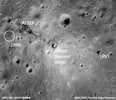
 The Apollo 15 Lunar Laser Ranging RetroReflector (LRRR) array is one of four such working arrays on the surface of the Moon (Long-term Degradation of Optics on the Moon, March 4, 2010). As the largest (105 x 65 cm in size) it serves as the primary target for laser ranging to the Moon. In this calibrated image it appears as the (circled) tiny white rectangular feature farthest to center left (near the edge of the original NAC image). The distance to these retroreflectors from the Earth can be and is still routinely measured to the centimeter level or better, and their relative positions are known to a similar level. Such measurements can be used for several purposes, such as precisely determining the orientation and orbit of the Moon, testing gravitation and general relativity theories, and for establishing a highly precise latitude and longitude coordinate frame for the Moon. The (original) image width is 391 meters, with a pixel width of 52 cm. Subset of NAC frame M111578606LE [NASA/GSFC/Arizona State University].
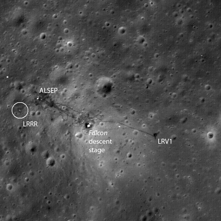
Brent Archinal
LROC News System
 The close-up above of the Apollo 15 landing site (26.1°N 3.6°E) is a portion of one of several LROC narrow angle camera (NAC) images that show the site (see earlier released image). Although near the edge of the NAC image M111578606LE, this close-up (about 391 meters across, at 52 cm/pixel) shows many pieces of hardware left on the surface by the Apollo 15 astronauts, including of interest here the Apollo 15 lunar Laser Ranging RetroReflector (LRRR) array. It was placed on the Moon by astronaut David Scott on 1971 July 31. A photograph of a portion of the LRRR taken by Scott is shown below. The Apollo 15 array is one of four usable such arrays on the Moon. The others are at the Apollo 11 and Apollo 14 sites, and on the Lunokhod 2 rover (see here for information on Lunokhod 2).
(Another of the French-built (and smaller than those of Apollo) LRRR array was situated on the original Soviet lunar rover Lunokhod 1, with inconclusive detection never again repeated after that mission, near the Sea of Rainbows, came to an end in 1970.)
Finding your position on the Moon can be tricky. Since the 17th century, the Moon's coordinates have been measured in what is now known as the “mean Earth/polar axis system,” or ME system for short. This is a latitude and longitude system where the mean (average) direction of the Earth over time defines the 0° longitude, or prime meridian, and the average direction of the Moon’s polar axis defines 90° north and south latitude. However, in order to effectively use such a system, it is necessary to assign latitude and longitude to a set of points on the Moon. This is where the LRRR arrays come in. Over the years since they were emplaced on the Moon, lunar laser ranging (LLR) observations of these arrays from several sites on the Earth have been processed and the relative positions of these arrays determined to the centimeter level. These relative coordinates have been converted to absolute latitude and longitude coordinates according to the above definition of the ME system, and thus are now the points on the Moon whose positions are most accurately known.
 A portion of the Apollo 15 lunar laser ranging retroreflector array, as placed on the Moon and photographed by D. Scott [NASA photo AS15-85-11468]. (According to the Apollo 15 Surface Journal Comdr. Dave Scott observed that the LRRR looked "super clean" when he and Jim Erwin deployed the mission surface experiments July 31, 1971. He took the cross-Sun view of the LRRR above from the south, showing the orientation gnomon and bubble level. Four times the size of the retro-reflectors deployed by Apollo 11 and Apollo 14, the third and final U.S. LRRR deployed by Apollo 15 is the unit most often detected from Earth. Though lasers and photon detectors have improved many times over in the past four decades, and though First Look at the Apollo landing sites by the Lunar Reconnaissance Orbiter Camera (LROC) last summer showed equipment and astronaut footprints undisturbed, something has been steadily degrading the amount of light these important mirrors are returning back to Earth).
(A Follow-Up on "Dust accumulation on Apollo laser reflectors may indicate a surprizingly fast and more dynamic lunar exosphere," February 16, 2009)
However, for the general purpose of locating things on the Moon, knowing the positions of only four points is not particularly useful. Therefore an important step in being able to use the data being returned from the LRO mission, as well as from previous U. S. and international missions, is to connect those datasets to the LLR coordinates. For LRO, a first step will be to determine the coordinates of LROC images and digital elevation models (DEMs) (see here) covering the LRRR sites). A second step will be to compare the positions of LRO Lunar Orbiter Laser Altimeter (LOLA) data to these images and DEMs in order to make sure that the global LOLA dataset is connected to these coordinates. The final step will be to assure that all other LROC and eventually even past U.S. and international mission data are in the same LLR coordinate frame. This will assure that lunar datasets will be in the same coordinate frame and that such data can be used together, consistently, for human exploration planning and associated science activities.
For more information on connecting lunar datasets together, read this 2010 Lunar and Planetary Science Conference abstract.
Explore the rest of the Apollo 15 landing site area (http://wms.lroc.asu.edu/lroc_browse/view/M111578606LE).

Looking west along the orbital path of the Apollo 15 command module, the yellow arrow indicating the arrival path of the lunar module into Hadley Delta and demonstrating why Scott & Irwin were fortunate not to have seen their glide slope during the lunar module's terminal descent, with forward horizon coming into view after having cleared the high mountains of the Hadley ridge. Beyond the southwestern Imbrium basin is gradually being pasted over, like wall paper, with high-resolution laser Apollo by LROC's high-resolution narrow-angle camera (NAC) on board the Lunar Reconnaissance Orbiter [NASA/GSFC/Arizona State University/Google].
No comments:
Post a Comment