Showing posts with label Lunokhod-2. Show all posts

Friday, May 23, 2014

Lunokhod 2: Trundling Across the Moon

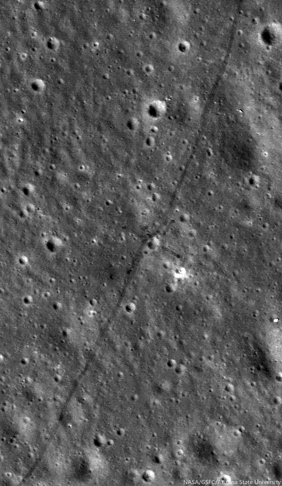
Tracks made by Lunokhod 2 in 1976 as the Soviets tested for variations in the local magnetic field while traversing around a small crater (25.764°N, 30.474°E) inside le Monnier crater, on the eastern edge of Mare Serenitatis. From LROC NAC observation M122007650R, LRO orbit 3114, February 28, 2010; 36.59° incidence angle, resolution 50 cm from 43.89 km [NASA/ GSFC/ Arizona State University].
Mark Robinson
Principal Investigator
Lunar Reconnaissance Orbiter Camera
Arizona State University

On 15 January 1973, just one month after the successful Apollo 17 mission culminated the US Project Apollo, the Soviet Luna 21 spacecraft landed softly just 170 km north of the Apollo 17 site on the eastern margin of Mare Serenitatis.

A day later on 16 January the rover Lunokhod 2 disembarked and, on 18 January, with a full battery charge it circumnavigated and imaged its faithful lander and began its record-setting journey across the lunar landscape.

The eight-wheeled rover was operated by controllers in Simferopol, Crimea, mainly using a mast-mounted TV camera and ‘joystick’ controls and roved the lunar surface for five Earth months, surviving four bitterly cold lunar nights (as low as -150 °C (-240 °F)) and racking up about 39 km (~24.4 miles) of traverse distance.

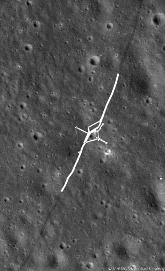
The original reported distance was 37 km, which made Lunokhod 2 the planetary rover traverse distance record holder! Along its traverse, Lunokhod 2 carried out a series of scientific experiments that were not well publicized in the United States.  Today’s Featured Image shows a cross-like pattern of rover tracks made as Lunokhod 2 explored a small crater, making various scientific measurements.

A typical Lunokhod operations crew included a commander, a navigator, a driver, an engineer, a radio/antenna operator, and one man in reserve.

Panorama taken by Lunokhod 2 at the crater shown in LROC NAC observation M122007650R (cropped from L2_D03_S03_P05m). The main experiments at this location were to test for changes in the local magnetic field due to the crater and characteristics of the regolith [Courtesy of Roskosmos and Russian Academy of Sciences].
Tracing the tracks in LROC NAC images, with new accurate geodetic controls that incorporate the latest topographic information from LROC and LOLA, the length of the Lunokhod 2 traverse is now accurately determined and is greater than the originally estimated 37 km.  In fact, the intrepid Lunokhod 2 traversed approximately 39 km!  The new traverse measurements were carried out by scientists at Moscow State University, and then again by a team at Washington University in St. Louis. The distance measurements follow the complete route shown by the tracks: including a “tripled” segment about 2 km in length, several long, linear magnetometer traverses, and several impact crater crossing maneuvers.

Lunokhod 2 traverse overview, low resolution version of six NAC image mosaic (original 1.3 m pixel scale), Sun from the west (see also Abdrakhimov, 42nd LPSC 2011) [NASA/GSFC/Arizona State University].
LROC NAC M122007650R, with portion of Lunokhod 2 rover tracks highlighted, where instruments gathered magnetometer measurements and did a triple traverse. Small circles can also be seen where the Lunokhod turned in place to take panoramic images [NASA/GSFC/Arizona State University].
Exploring Hilly Terrain

During the Lunokhod 2 mission, as the deputy leader of the Scientific Team and leader of the Geology Group, Dr. Alexander “Sasha” Basilevsky worked tirelessly to maximize the science return of the mission. Meeting this goal was not so easy because the Managing Group (Crew plus representatives of Lavochkin Association, which built the Lunokhods) was mostly thinking about demonstrating the roving and control capability of Lunokhod 2, and establishing a new distance record. Dr. Basilevsky recounts,
“So when moving south from the landing point, we crossed the mare area and reached a hilly terrain (low "highland" terrain).  I was planning to study it and then to go north and then east towards a graben later called Fossa Recta. But the managing team did not like long sessions of TV stereo-imaging and other measurements, and they sent Lunokhod back to the north despite my protests.
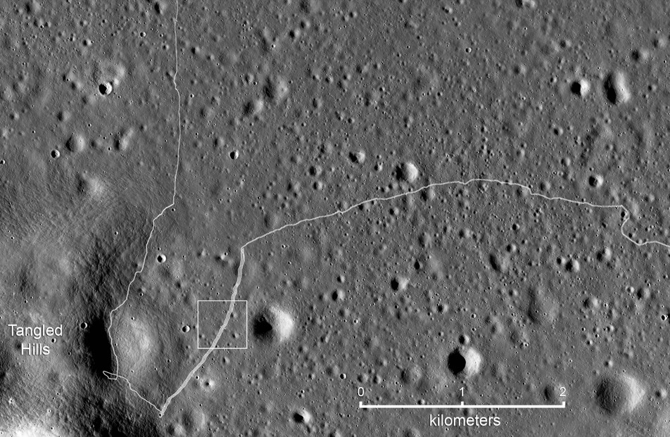
Detail map of the SW portion of the Lunokhod 2 traverse. White box indicates the field of view shown at high-resolution in the LROC Featured Image released May 2014 [NASA/GSFC/Arizona State University].
“So I called to Moscow to the head of my laboratory, Professor Cyrill Florensky, he called to Vice President of Academy of Sciences Academician Alexander Vinogradov, and Vinogradov called Sergei Kryukov, the Lavochkin Association director, and explained that the hilly terrain had to be studied. Kryukov agreed and called to the Lunokhod Control Center in Crimea where we were and said, ‘please, follow the suggestion of that guy Basilevsky.’
“Meanwhile Lunokhod 2 proceeded quite a long way. After the Kryukov call worked, the crew just turned the vehicle back and then drove along the track. That was safe and they could be fast. When Lunokhod 2 came back to the hilly terrain station we made several panoramas, and then drove back to north along the double track and again could be fast.
“So the result was good for both sides of the [issue]: For science: we studied [the hilly] terrain, and for the Managing Group: Lunokhod made a lot of meters.”
At the conclusion of the ‘tripled’ traverse segment, Lunokhod 2 had racked up about 17 km of odometry. Controllers then began the long eastward drive to Fossa Recta (‘Straight Rille’), crossing Fossa Inconspicua (‘Unnoticed Rille’) along the way. Magnetometer experiments were done along the tripled traverse to test for effects related to the mare-highland boundary, and later, on the east and west sides of Fossa Recta (see below). Other observations and measurements included soil compositional analyses using an X-ray fluorescence spectrometer, soil mechanics experiments using a penetrometer, solar X-ray monitoring, a photodetector to detect UV light sources and the level of Earth-glow on the night-time Moon, laser ranging, 86 panorama photos, and some 80,000 TV pictures. The laser ranging retroreflector, a French instrument, is still in use today.

Fossa Recta Exploration

On its fourth lunar day of roving, Lunokhod 2 explored a linear depression (graben or rille), Fossa Recta. After approaching the depression, the Lunokhod was driven along a path leading away from its edge to measure any changes in the local magnetic field associated with the depression, and then back along the same path to the edge again.  By reversing its direction and retracing its path, the effect of the Lunokhod, itself, on the magnetic signal could be determined and subtracted from the signal. A portion of the panorama taken by Lunokhod 2 when it approached the graben of Fossa Recta is shown below.
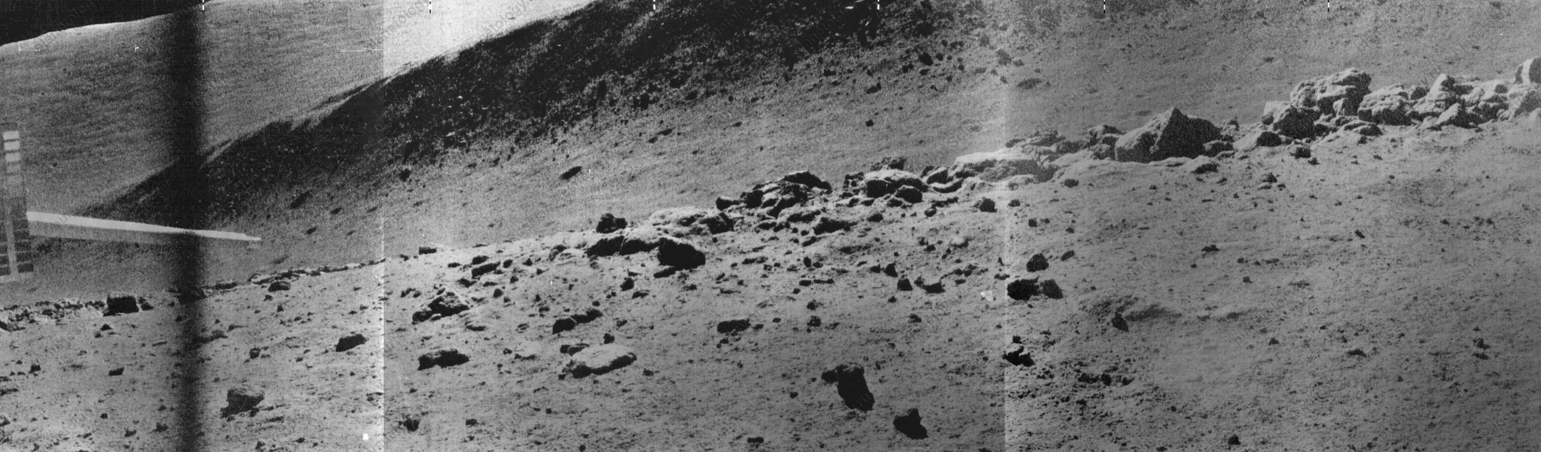
Part of the Panorama (L2_D04_S11_P09m) showing a portion of the Fossa Recta, stretching from north (left) to south (right) and a boulder field in the foreground. The sharp object on the left side of the panorama is the soil penetrometer [Courtesy of Roskosmos and Russian Academy of Sciences].
When the panorama was taken, Lunokhod 2 was on the western edge of Fossa Recta, at the position shown above, and boulders on the very edge of the depression are readily seen. The boulders were described in a paper by Basilevsky, Florensky, and Ronca (1977) in a scientific journal, The Moon, Vol. 17, and interpreted as boulders derived from lava bedrock at the edge of a long linear depression.  The characteristics observed at the edge of the fossa are similar to those seen by Apollo 15 astronauts Dave Scott and Jim Irwin at Hadley Rille. After exploring Fossa Recta Lunokhod 2 was nowhere near done!

Related Posts

Wednesday, February 26, 2014

You too, Yutu?

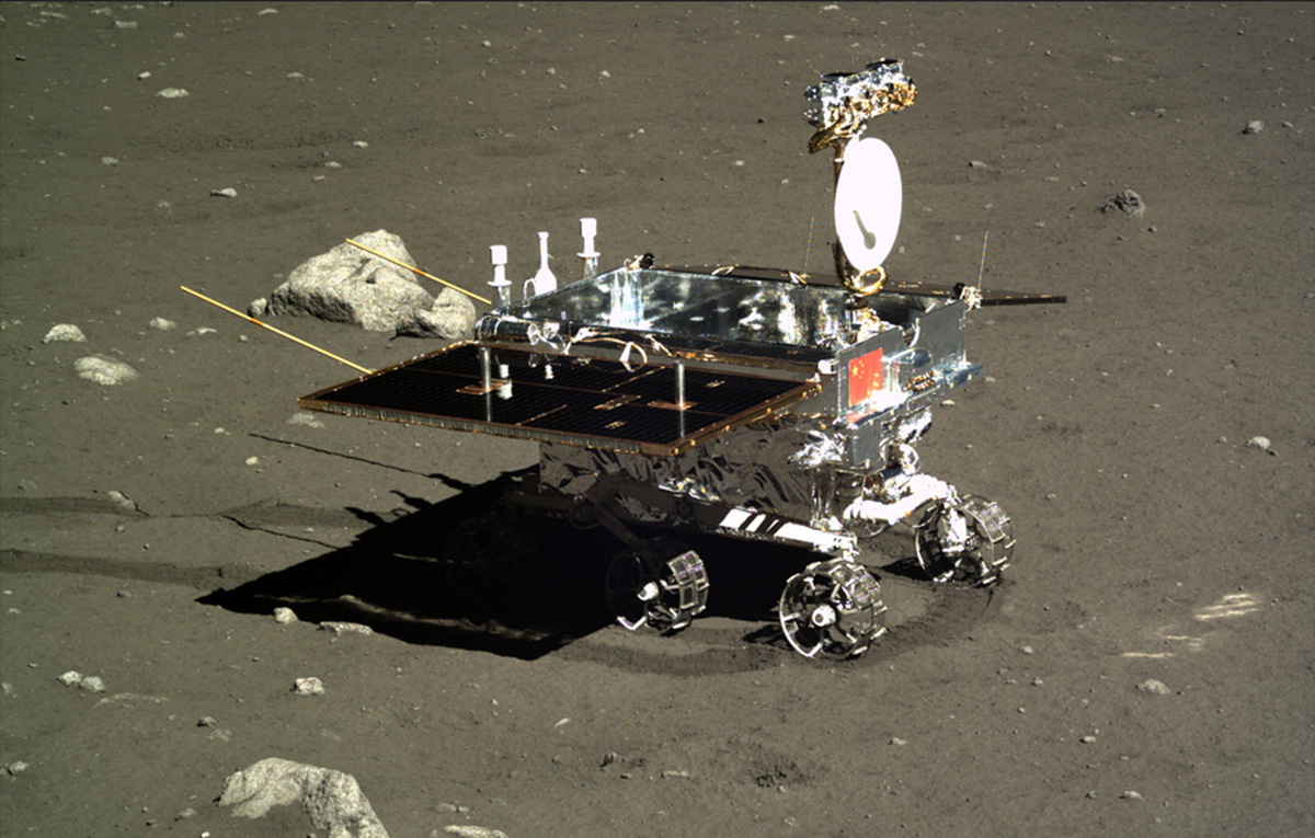
Jade Rabbit, "Yutu," the first lunar rover since Lunokhod-2 explored Le Monnier crater for the first half of 1973, in profile, as seen from the Chang'e-3 Panoramic Camera soon after deployment and its first tantalizingly brief trip across a few square meters of Mare Imbrium. The twin dipole antenna extending behind the vehicle are its ground-penetrating array [CAS/CNSA/CLEP].
Paul Spudis
The Once and Future Moon
Smithsonian Air & Space

Another lunar day has come and gone on the barren plains of Mare Imbrium.  How fares its most famous terrestrial inhabitant, the Chang’E 3 spacecraft and Jade Rabbit, the little Yutu rover?  The fact is, we really don’t know and those that presumably do aren’t talking about it much.

The Yutu rover of the Chang’E 3 mission has experienced some “mechanic control abnormality due to the complicated lunar surface,” is how the Chinese phrased the situation.  Details on the nature of the problem are impossible to come by, but one clear result is that the Yutu cannot move.  It apparently spent the last lunar day (which lasted from about 10 February until last weekend) sitting in one place.  For some scientific investigations, that is not necessarily a problem, but for Yutu’s primary scientific mission, it is fatal.

The goal of placing a rover on the Moon is to explore and examine multiple sites distant from each other.  Additionally, the traverse between stations enables unique experiments, such as profiling the surface – the principal objective of the ground-penetrating radar on China’s rover.  As the vehicle moves across the lunar surface, it emits radio waves of varying frequency into the surface.

Reflections from subsurface layers or boundaries are then received by the rover’s antenna, thereby allowing scientists to infer subsurface structure.  To get a subsurface profile, these measurements must be taken while the rover is moving.  Thus, an immobile rover makes this experiment impossible.

The rover’s other instruments operate during a stationary period.  However, once a chemical measurement has been made or an image taken, there is little value in continually repeating it.

If the Yutu rover is immobile, its scientific mission is effectively over.

News reports have stopped giving us data and information from the Chang’E 3 lander (which has a camera and an ultraviolet telescope) but assuming it is still operating, it may continue making observations.  The lander spacecraft made a panorama of the landing site, so that objective was completed.  Presumably, if the UV telescope is still operating, it can continue observing the sky but these observations are not significant to lunar science.

Three LROC NAC views of the Chang'e-3 landing site in north Mare Imbrium (44.1214°N, 340.4884°E, -2630 m elev.), before landing, after deploying the Yutu rover (south of the lander) and after Yutu was moved just to the southeast of the lander, where it apparently failed (and remains) reportedly following a ground-operations error during preparations ahead a long lunar night [NASA/GSFC/Arizona State University].
Thus, from the perspective of lunar science, it appears that the Chang’E 3’s Moon mission is over.

So, how did Yutu do as a lunar explorer?  For now, we really don’t know.  Aside from a few color images and a chemical spectra that was released to the press, little scientific data has been revealed (a Google translate version of a Chinese web page describing the Chang’E 3 science to date can be read HERE).  The data we have seen mostly show that the instruments were functioning.  We do not know how many measurements were made, what they have told us, or the geological setting of the chemical analyses.

The Chang’E 3 lander set down very near the rim of a crater 450 meters in diameter, a feature whose walls are littered with angular blocks clearly derived from the local bedrock. The fact that the Yutu did not make an immediate beeline over to those blocks for a detailed examination and chemical analysis tells me one of two things: either those planning the rover’s exploration traverse are not geologists or they didn’t get to it before the rover stopped working.

Yutu has led a famous existence in cyberspace, with numerous “tweets” to the world.  A public eager to anthropomorphize machines has responded in kind, including offering several admonitions to the rover to “pay attention to his wake-up calls.”  All this rhetorical cuteness hides the fact that China has been less than forthcoming about this mission, as they are about all of their space missions.  We hear only what they want us to hear.  Successes (of which they have had many) are widely trumpeted with blasts of publicity, while difficulties and failures are buried in silence.  It’s true that a space program run by the military (in the case of China, the People’s Liberation Army) will tend toward such an ethic.  But the WALL·E-like image promoted by China early in the mission is not the image conveyed by their current posture with the world press.

I find the Chinese attitude both interesting and dismaying.  It is similar to one that I experienced with Indian Space Research Organization (ISRO) during the Chandrayaan-1 lunar orbiter mission.  When the Chandrayaan spacecraft was running into difficulties after a few months in lunar orbit, the organizational instinct was to deny any problems and be less than forthcoming with the press about the status of the spacecraft.

Spaceflight is inherently difficult and things break all the time.  It is beyond ridiculous to cover up a problem by pretending that it doesn’t exist.  Similar behavior patterns characterized the early Soviet space program, in which we never heard about mission failures, but successes were given widespread publicity.  It seems that to date, China is adhering to that model.

There has been much in the media about the non-welcoming posture of some towards engagement and possible cooperation with China in space – admonishing Congress and NASA to be open to cooperating with China on future space missions.  There may come a time when this is possible but for now, it seems that reality is far away.

Dr. Paul D. Spudis is a senior staff scientist at the Lunar and Planetary Institute in Houston. This column was originally published by Smithsonian Air & Space, and his website can be found at www.spudislunarresources.com. The opinions he expressed here are his own, and these are better informed than most.

Related Posts:
It's not bragging if you do it (December 9, 2013)
China's Long March to the Moon (January 14, 2012)

Tuesday, November 19, 2013

Lunar Laser Ranging: The Millimeter Challenge

Lunar Laser Range Reflector arrays
The five Lunar Laser Range Reflector (LLR or LLRR) arrays deployed on the lunar surface, one each at the landing sites of Apollo 11, 14 and 15, and also to the Soviet rovers Lunokhod 1 and 2. The sublime accuracy of the decades-long measurements are priceless to astrophysics. Nearside view from "Synthetic View of the Moon," LROC Featured Image released October 15, 2013 [NASA/GSFC/Arizona State University].
T. W. Murphy, Jr.
Center for Astrophysics and Space Sciences
University of California

Lunar laser ranging has provided many of the best tests of gravitation since the first Apollo astronauts landed on the Moon. The march to higher precision continues to this day, now entering the millimeter regime and promising continued improvement in scientific results. This review introduces key aspects of the technique, details the motivations, observables, and results for a variety of science objectives, summarizes the current state of the art, highlights new developments in the field, describes the modeling challenges and looks to the future of the enterprise.

Since 1969, lunar laser ranging (LLR) has provided high-precision measurements of the Earth-Moon distance, contributing to the foundations of our knowledge in gravitation and planetary physics. While being the most evident force of nature, gravity is in fact the weakest of the fundamental forces, and consequently the most poorly tested by modern experiments. Einstein's general relativity, currently our best description of gravity, is fundamentally incompatible with quantum mechanics and is likely to be replaced by a more complete theory in the future. A modified theory would, for example, predict small deviations in the solar system that, if seen, could have profound consequences for understanding the universe as a whole.

Utilizing reflectors placed on the lunar surface by American astronauts and Soviet rovers, LLR measures the round-trip travel time of short pulses of laser light directed to one reflector at a time. By mapping the shape of the lunar orbit, LLR is able to distinguish between competing theories of gravity. Range precision has improved from a few decimeters initially to a few millimeters recently, constituting a relative precision of 10-9 through 10-11. Leveraging the raw measurement across the Earth-Sun distance provides another two orders of magnitude for gauging relativistic effects in the Earth-Moon-Sun system.

The largest of the Apollo lunar laser range reflectors (LLRR) arrays, deployed at Hadley Rille by Scott and Irwin of the Apollo 15 surface expedition in February 1971. The instrument is still a regularly acquired critical part of on-going experimental astrophysics. AS15-85-11468 [NASA/JSC].
As LLR precision has improved over time, the technique has remained at the cutting edge of tests of gravitational phenomenology and probes of the lunar interior, and has informed our knowledge of Earth orientation, precession, and coordinate systems. LLR was last reviewed in this series in 1982; this update describes the key science drivers and findings of LLR, the apparatus and technologies involved, the requisite modeling techniques, and future prospects on all fronts.

Lunokhod 1 rover in its final parking place (38.315°N, 324.992°E) on the surface of Mare Imbrium. LROC Narrow Angle Camera (NAC) observation M175502049RE, orbit 10998, November 9, 2011, resolution 33 cm per pixel. View original Featured Image released March 14, 2012 (with enlarged inset) HERE [NASA/GSFC/Arizona State University].
LLR is expected to continue on its trajectory of improvement, maintaining a leading role in contributions to science. Other recent reviews by Merkowitz (2010) and by Muller, et al. (2012) complement the present one. The Merkowitz review, like this one, stresses gravitational tests of LLR, but with greater emphasis on associated range signals. Next-generation reflector and transponder technologies are more thoroughly covered. The Muller et al. review (for which this author is a co-author) covers a more complete history of LLR, has statistics on the LLR data set, and provides greater emphasis on geophysics, selenophysics, and coordinate systems.

This review is organized as follows: Section 1 provides an overview of the subject; Section 2 reviews the science delivered by LLR, with an emphasis on gravitation; Section 3 describes current LLR capabilities; Section 4 relates recent surprises from LLR, including the finding of the lost Lunokhod 1 reflector and evidence for dust accumulation on the reflectors; Section 5 treats the modeling challenges associated with millimeter-level LLR accuracy; and Section 6 covers possible future directions for the practice of LLR.

Thursday, October 31, 2013

Chang'e 3 & LADEE: The Role of Serendipity

The Chang’E 3 spacecraft sets down on the Moon, and exhaust gas from its descent rockets change the lunar exosphere [NASA/CNSA].
Paul D. Spudis
The Once and Future Moon
Smithsonian Air & Space

The Lunar Atmosphere and Dust Environment Explorer (LADEE) spacecraft is currently circling the Moon.  With the spacecraft safely settled into its observation orbit, the mission science team is busy testing and calibrating its instruments.  This U.S. mission was designed to characterize the lunar “atmosphere” – the extremely tenuous zone of gases that vary in time in the space above the Moon.  Technically called an exosphere, this region contains extremely low concentrations of a variety of elements and compounds, of varied origins and a largely unknown life cycle.  LADEE is designed to monitor and characterize these species, with the goal of identifying the process and sources of the gases and how they vary with time.

Initially a precursor to human lunar return, LADEE was selected for development early in 2008, as we wanted to understand the lunar exosphere before the lunar environment was contaminated by humans.  The LADEE spacecraft is designed to observe the Moon in its natural, pristine state.  However, the very act of going to the Moon inadvertently (though briefly) modifies the lunar atmosphere.  When a spacecraft arrives at the Moon, it uses its on-board rocket engines to brake into lunar orbit or to descend to the surface.  These rockets spew large quantities of exhaust gas into space and as the vehicles get captured into the Moon’s gravity field, so too does this exhaust product.

From estimates drawn on the Apollo landings, the rocket exhaust expended from each Lunar Module temporarily doubled the total mass of the natural lunar atmosphere.  This artificial addition of gases eventually dissipates, driven off by solar interactions and other complex effects.  In time, the Moon resumes its normal state of near-vacuum.  The creation of a temporary artificial atmosphere created by rocket effluent and its subsequent dissipation is imperfectly understood, except to the extent that we know that it happens.  The one-month “commissioning phase” that the LADEE mission is currently experiencing was largely designed to ensure that the exhaust from the orbital braking burn of the spacecraft (and subsequent low-rate out-gassing from the spacecraft) is largely complete.  We want to measure the Moon’s environment, not the products of the craft that brought us there.

But the U.S. will not be the only one conducting a mission at the Moon for the next few months.  The long-planned Chinese robotic mission Chang’E 3 is scheduled for launch to the Moon in early December.  Their lander mission will place a fairly large (1200 kg) spacecraft on Sinus Iridum in the northwestern quadrant of the near side, deliver a small roving vehicle and examine and measure the properties of the lunar surface over the course of several months.  But before it begins its surface mission, the Chang’E 3 spacecraft will burn roughly 2600 kg of rocket fuel in the vicinity of the Moon’s exosphere.  I have not seen any documentation on the fuel this spacecraft will use, but it is highly likely that it will be the chemicals unsymmetrical dimethylhydrazine (UDMH; H2NN(CH3)2) and nitrogen tetroxide (N2O4).  These propellants are widely used in spacecraft because they are liquid at room temperature and can be easily stored in tanks for long periods of time (a requirement for long-duration spaceflight to destinations beyond low Earth orbit).

When UDMH and nitrogen tetroxide are burned in a rocket engine, they produce a variety of exhaust gases; the dominant combustion products are water (H2O), nitrogen (N2), carbon monoxide (CO), carbon dioxide (CO2), and a few trace species, including hydrogen (H2) and hydroxyl (OH).  Expelled by a rocket nozzle, these gases rapidly expand in all directions in the vacuum of space.  Because most of the burn occurs after the spacecraft has been “captured” by the gravity of the Moon, this rocket exhaust is also captured by the Moon.  Thus, exhaust from an orbital or a landing vehicle becomes (temporarily) part of the lunar atmosphere.

If you’re thinking that this “rude” addition of alien gases will mess up the very delicate phenomena that LADEE was designed to map and measure, you’re correct – it does.  You might even expect the scientists of the LADEE team would be very upset at this disruption of their carefully planned measurement strategy.  But you would be wrong.  This problem is actually an opportunity.

If successful, Chang'e 3 will perform the first soft-landing on the
Moon since Luna 24 in1976 and deploy the first lunar rover
 since Lunokhod 2 in 1973 [NASA/CNSA].
The coincidence of Chang’E 3 arriving at the Moon after LADEE has begun observations has developed into a serendipitous occurrence for lunar science.  Because we don’t understand very well how exospheric gases are added to and removed from the Moon, what has landed in our laps is an unplanned (but controlled) experiment.  A known quantity of gases – of known composition – will be added to the lunar atmosphere at a precisely known time, in a precisely known place.  One could have not designed a better experiment to measure how this addition of material is distributed, how its distribution evolves over time, and how these expelled gases dissipate into cislunar space.  Even better, LADEE will have almost a full month to monitor and characterize the lunar atmosphere before Chang’E arrives, thus allowing us to first observe the “natural” Moon and then the “contaminated” Moon and how the lunar atmosphere recovers from its defilement.

None of this was prearranged – the Chinese schedule their missions on the basis of their own time-table and programmatic needs (just as NASA’s lunar goals have changed over the last 5 years).  But because of a fortuitous alignment of schedules, we have a unique opportunity to observe in real time how the Moon works.  Hopefully, the Chinese will provide us with detailed mass numbers of their spacecraft and exactly what variety of fuel it carries, but even if they don’t, physics dictates a certain mass and volume of the exhaust gas and its composition will be measured by LADEE (allowing us to know the type of fuel used).  China’s December lander mission to the Moon will provide our U.S. mission with a welcome bit of  “traffic exhaust,” giving scientists the opportunity to learn more from LADEE than we’d originally envisioned.

Serendipity indeed.

Originally published October 30, 2013 at his Smithsonian Air & Space blog The Once and Future Moon, Dr. Spudis is a senior staff scientist at the Lunar and Planetary Institute. The opinions expressed are those of the author but are better informed than average

Monday, September 17, 2012

Close-up on the lonely trail of Lunokhod-2

Long and winding road of the last rover deployed on the Moon, Lunokhod-2. Image cropped from a diagonal slice through the rover trail swept up in an extreme close-up of Le Monnier crater August 14, 2012. LROC Narrow Angle Camera (NAC) frame M168000478R, LRO orbit 9892; resolution 41 cm per pixel, angle of incidence 47.65° from 22.11 kilometers [NASA/GSFC/Arizona State University].
The Soviet Union's Lunokhod-2, riding to the lunar surface on the Luna-21 lander, arrived on the Moon January 15, 1973. The 84 kg. rover Lunakhod-2 was afterward deployed and, with the benefit of a robust radioisotope thermoelectric generator to warm itself through the long lunar nights, was teleoperated a total of 37 km, across the southern floor of le Monnier crater, until the following June.

It's not quite as easy to distinguish the twin ruts of the Lunakhod trail in the mosaic of both the right and left-hand frames of LROC NAC observation M168000478. The unusual close-up, from less than half the nominal 50 km altitude, was caught as flight directors prepared to raise LRO's orbit to above 100 km at the end of 2011. Because the camera was considerably closer to the surface, the field of view is quite a bit more narrow, in compliance with the Inverse Square Law, slightly less than one-half kilometer across. LRO was slewed a full 25° off nadir, which resulted in the right-hand frame being very slightly more distorted than the left [NASA/GSFC/Arizona State University].
LROC principal investigator Mark Robinson discussed the Lunokhod-2 mission in detail on March 13, HERE. Also, there are spacecraft panoramas and close-ups of both Luna-21 and Lunokhod-2 at the following links:

Lunokhod-2 revisited (March 13, 2012)
Luna 21 (March 20, 2010)
Lunokhod-1 and Lunokhod-2 (March 17, 2010)

Phil Stooke's familiar survey of the Lunokhod-2 traverse is seen here graced with the scaled mosaic of LROC NAC M168000047, at lower left. The small white box shows the field of view seen at 41 cm resolution in the opening image, above [Google Earth].
ILIADS application perspective of le Monnier, LROC Wide Angle Camera 100 meter global monochrome mosaic draped over LOLA 128 ppd digital elevation model (v.2) [NASA/GSFC/Arizona State University].