
 |
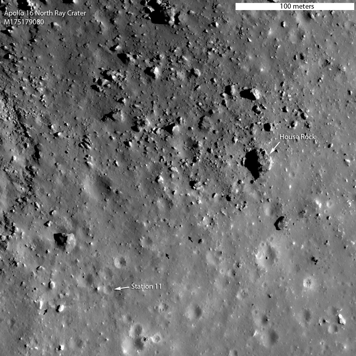
| Area on the southeastern rim of North Ray crater explored by Apollo 16 astronauts John Young and Charlie Duke, revealed in striking resolution in recent low altitude LROC Narrow Angle Camera (NAC) mosaic M175179080NR, orbit 10,950, November 6, 2011. The above detail from the field of view in the release is 300 meters wide, (small arrows show the foot tracks of Young & Duke left behind during their traverse from the rover, to and from House Rock. View the full size Featured Image HERE. (Compare this image with John Young's picture of Home Rock taken from Stone Mountain in 1972 at the end of this post) [NASA/GSFC/Arizona State University]. |

Principal Investigator
Lunar Reconnaissance orbiter Camera
Arizona State University
One of the main goals of the Apollo 16 mission was to explore and sample a young bright rayed crater aptly named North Ray crater (890 m diameter). Its high albedo is due to its young age. During an impact event geologic material from depth is excavated and spread around a crater. The deepest material ends up near the rim, and the shallower material is thrown out farther. The pre-existing surface was mature, meaning that its albedo was diminished over time due to solar wind and micrometeorite bombardment (space weathering).
The fresh material from depth had not suffered these effects, thus its high albedo. If you wait, you can observe the North Ray crater's albedo decrease over time - but you would have to be very patient, since this space weathering process takes hundreds of millions of years to complete. At the time of the Apollo 16 mission scientists did not know the age of North Ray crater, nor did they know as much as we know today about the details of the space weathering process, so an important goal was to learn what young really means on the Moon.
The fresh material from depth had not suffered these effects, thus its high albedo. If you wait, you can observe the North Ray crater's albedo decrease over time - but you would have to be very patient, since this space weathering process takes hundreds of millions of years to complete. At the time of the Apollo 16 mission scientists did not know the age of North Ray crater, nor did they know as much as we know today about the details of the space weathering process, so an important goal was to learn what young really means on the Moon.
 |
| North and South Ray craters are familiar companions in the southern nearside lunar Highlands in earthbound telescopes, making it unusually easy to spot the landing site of Apollo 16, at least in the mind's eye, situated directly between them. This detail is from a large November 6, 2011 mosaic put together by Yuri Goryachko, Mikhail Abgarian, Konstantin and Konstantin Morozov of Astronominsk, in Minsk, Belarus [Astronominsk]. |
 |
| From 400,000 to a mere 43 kilometers away, an LROC Wide Angle Camera (WAC) monochrome (643 nm) mosaic of North and South Ray craters, and the landing site of Apollo 16, April 21, 1972; LRO orbits 6778 and 6779, December 13, 2010, incidence angle 74.6° with a resolution of 60 meters from 43 kilometers [NASA/GSFC/Arizona State University]. |
 |
| Apollo 16 traverse map, overlain on Apollo metric camera mosaic in Google Earth. View the map accompanying the Featured Image HERE. |
North Ray crater, which is almost 250 m deep, was the largest and deepest crater visited during the Apollo 16 mission, and its rim was the stop known as Station 11, visited on the third and final EVA. Because the rim sloped off gradually into the crater, and the crater was so deep (relative to its diameter), the astronauts could not actually see the bottom of the crater while standing on its rim.
It was hoped by pre-mission planners that the astronauts would look into the crater and see discrete layers of highlands volcanic rocks.
When John Young and Charlie Duke actually got to North Ray, the astronauts saw no evidence for lava layering in its walls. Rather, the samples they collected from the rim were almost all impact breccias, or rocks formed from the pieces of other rocks during a much larger impact event.
Since the crater is so deep, it excavated long-buried lithologies, so sampling North Ray rim materials provided important information about the geology of the Apollo 16 site.
The samples from the rim of North Ray almost certainly included material from the Descartes formation, one of two major geologic units at the Apollo 16 landing site.
 |
| John Young geologizing on the rim of North Ray crater. Their next destination will be House Rock, seen behind Young, above his right shoulder, AS16-106-17336 [NASA]. |
A particularly important sampling location on the rim of North Ray crater was dubbed “House Rock”, so-named because it appeared to be the size of a house to the astronauts.
As it turns out this house sized rock is actually 24 meters by 20 meters (79 by 65 feet)! A smaller rock (9 meters or 30 feet) directly to the south was dubbed “Outhouse Rock”, and several samples were collected at this location.
The samples collected on the rim of North Ray crater, including those from House Rock, represent our best look at the lunar highlands and the awesome process of basin ejecta emplacement. The breccias that were sampled by Young and Duke were all formed as massive flows of rock that traveled across the Moon's surface as result of the formation of the Imbrium basin and the Nectaris basin. The formation of North Ray crater brought breccias up from depths greater than 200 meters, allowing Young and Duke to sample a three-dimensional section of the local stratigraphy.
From these samples we now know that the region is not formed of unusual lavas, but rather basin ejecta. Now believed to represent materials that were excavated from near the bottom of North Ray crater, both of these rocks originally formed as part of giant impact breccias. Age-dating these samples back on Earth revealed that the materials that comprise House and Outhouse rocks formed about 3.9 billion years ago, although the North Ray impact that excavated House Rock itself occurred only about 50 million years ago. So we now know the age of formation of the massive ejecta flows, and we have an answer to how young is young: the age of the youthful North Ray crater is an important point on our absolute age scale of lunar events.
 |
| Charlie Duke samples a shatter cone formation in Outhouse Rock, a large fragment shed off the southern end of House Rock during the third and final EVA of Apollo 16. Note the accumulation of lunar dust after totaling 20 hours on the lunar surface. AS16-116-18649 [John Young/NASA/JSC/ALSJ]. |
Geologists mapped out two major units in the area: the Cayley formation, which lies on top of the Descartes formation (remember what lies on top is younger). Tentatively, the Cayley formation is interpreted to have formed as ejecta from the Imbrium basin, while the Descartes formation is thought to represent ejecta from the older Nectaris basin. Since rim samples of North Ray crater likely came from the bottom of the crater, scientists believe they represent the stratigraphically lower Descartes formation (Nectaris ejecta).
In general, the age-dating of the breccias collected on the rim of North Ray crater is currently considered to provide the best available estimate for the formation age of Nectaris basin (estimates range from 3.85 to 3.92 billion years ago), an important anchor for lunar stratigraphy.
 |
| LROC NAC stereo derived topography of North Ray crater. View the full-sized LROC context image HERE [NASA/GSFC/ Arizona State University]. |
Up to two times a day the LROC NAC obtains stereo pairs of key science targets, including the Apollo 16 site. The stereo images provide the means to make detailed topographic maps, a powerful tool for unraveling the local geology and planning future missions to the Moon (robotic and crewed). If Young and Duke had the above LROC topographic map, they might have planned a traverse part way into the crater, or perhaps all the way to the bottom!
Inspect the whole of North Ray crater at 25 centimeter pixel scale, HERE. Note the faint and bright rover tracks indicated with small white arrows, small black arrows point to astronaut tracks.
And just for fun: perspectives of North Ray crater made with NAC images and NAC topography at one-to-one vertical to horizontal scale (natural perspective). See if you can spot House Rock by comparing to the full resolution image map. Enjoy!
 |
| North to south perspective across North Ray crater. View the original HERE [NASA/GSFC/Arizona State University]. |
 |
| South to north perspective view of North Ray crater from close range, View the original HERE [NASA/GSFC/Arizona State University]. |
 |
| South to north perspective view of North Ray crater from far range. View the original HERE [NASA/GSFC/Arizona State University]. |
 |
| Looking north, 500mm high-resolution detail from AS16-108-17612 by John Young, taken from the heights of Station 4 on Stone Mountain across the Cayley plain toward the rim of North Ray crater. The Lunar Module Orion can be seen at lower left and at upper right, nearly twice as distant, is House Rock. Young and Duke would visit there the following day [NASA/GSFC/Arizona State University]. |
2 comments:
How can we get a clear image of locations 65, 265 on the moon? None of the camears online appear to cover that location.
If "65, 265" is the same as 65°N, 95°W (265°E) then we're talking about HERE.
If you're talking about the impact of Kaguya, there are high-res shots of the location. It appears to me, unconfirmed, the Kaguya orbiter impacted at 1.6 kps into the north wall of the crater and much of the debris field was covered in a subsequent landslide.
Post a Comment