Showing posts with label Samuel Lawrence. Show all posts

Wednesday, September 25, 2013

LROC updates image tally of human artifacts on the Moon

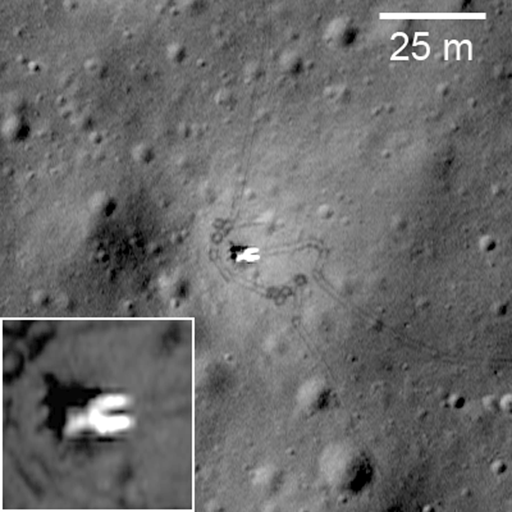
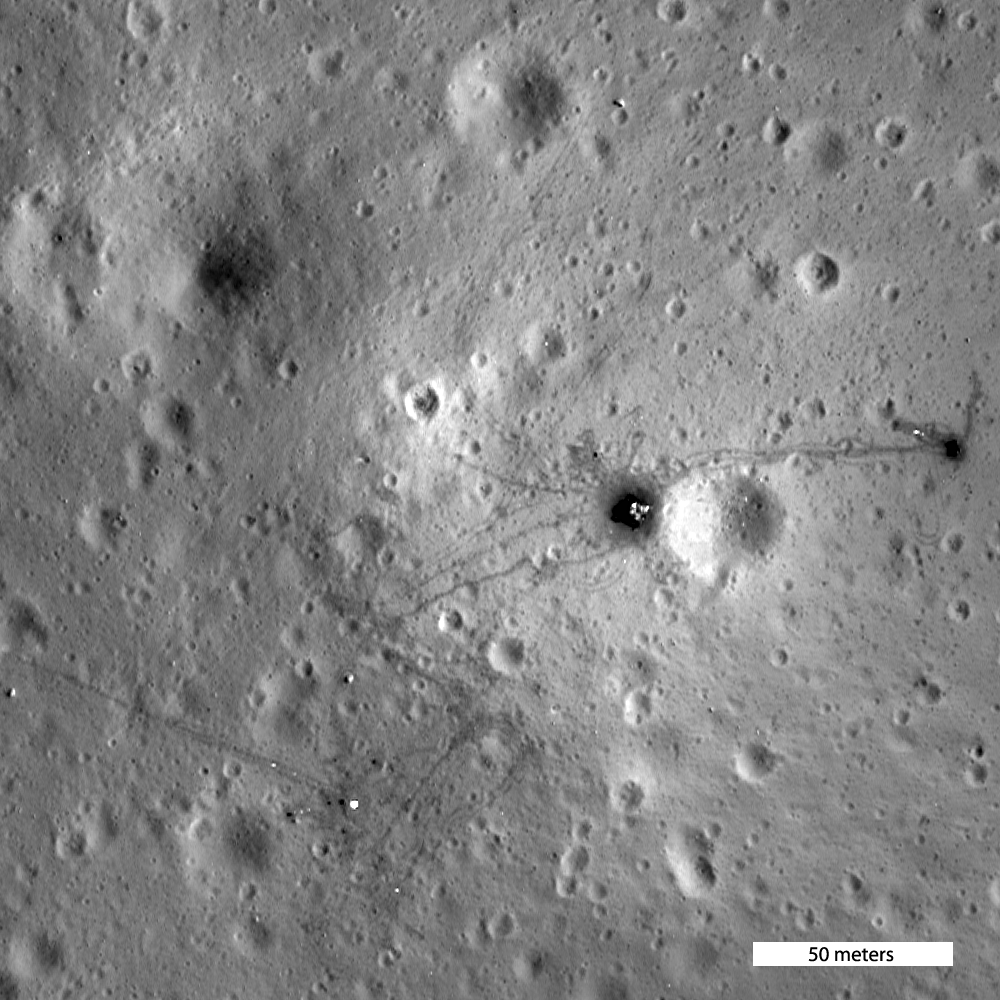
Luna 17, the spacecraft that carried the Lunokhod-1 rover to the surface of the Moon; debarking ramps for the rover tracks around the lander are visible, extending southeast, to the right. LROC Narrow Angle Camera (NAC) frame M175502049RE, LRO orbit 10998, November 9, 2011; angle of incidence 57.78° at 43 cm per pixel resolution from 30.66 km over 38.23°N, 325.01°E. View the original contextual image with an enlarged inset HERE [NASA/GSFC/Arizona State University].
Samuel Lawrence
LROC News System

Repeat imaging of anthropogenic targets on the Moon remains an LROC priority as the LRO Extended Science Mission continues. These continuing observations of historic hardware and impact craters are not just interesting from a historical standpoint - each image adds to our knowledge of lunar science and engineering, particularly cartography, geology, and photometry.

Making sure that the lunar cartographic network is accurate is a critical component for planning future lunar missions for both human and robotic exploration of the Moon. The historic spacecraft serve as benchmarks (especially the laser retroreflectors). When new images arrive and final ephemeris is in hand we can check if the hardware has moved - well, actually we see the level of uncertainty in computing latitude/longitude coordinates (currently about ±15 meters).

View of the Luna 17 lander from the Lunokhod-1rover (the vehicle descended from its position atop the lander from the opposite side). A wide variety of images, including many other firsts from the Soviet Union's lunar exploration program  of the Cold War era can be viewed HERE.
Currently the United States has no near-term plans to land humans or robotic spacecraft on the Moon, however China is scheduled to launch the Chang'e 3 mission in December. If we are lucky, the LROC team might have a before picture to compare to any after pictures of the Chang'e 3 landing site (the exact planned landing coordinates have not yet been released). Currently all LROC NAC investigations must rely solely on "after" images of landing sites. Obtaining a before and after set of images of the Chang'e 3 will facilitate a much better understanding of the delicate processes involved in regolith redistribution due to lander rocket plumes.

When a spacecraft lands on the Moon in a powered descent, exhaust gases from the descent engine disrupt the surface resulting in visible changes around the landed vehicle. These changes can be better understood with photometric studies using using LROC NAC images taken with different illumination geometries. Close to (or right under) the lander the soil is most disrupted, leading to reduced reflectance. Interestingly a zone of increased reflectance surrounds the lander. This "blast zone" ranges from a few meters for the Surveyor spacecraft, to a few tens of meters for Luna, and a few hundred meters for Apollo.

The Apollo 15 landing site through shifting shadows of a simulated lunar day, courtesy of the LROC Featured Sites Index. Very little appears to have changed since the departure of Scott and Irwin nearly 600 lunar days ago [NASA/GSFC/Arizona State University].
Photometric modeling indicates possible causes for the increased reflectance zones from smoothing of the surface by the exhaust flow, the destruction of micro-scale regolith structure, and/or the redistribution of fine particles from the area beneath the lander to its surroundings. Modeling the dynamics of rocket exhaust plumes and studying the exhaust plume effects of previous landed spacecraft on the Moon are defining safe operational practices for future landing sites and outposts.

Exceptionally detailed photograph of the Ranger 9 impact on the floor of Alphonsus crater appears to include an inner disk of darker material around 10 meters across, possibly melt created by the release of kinetic energy, LROC NAC M170579736R, LRO orbit 10272, September 13, 2011; angle of incidence 16.1° at 49.6 cm per pixel resolution from 44.64 km [NASA/GSFC/Arizona State University].
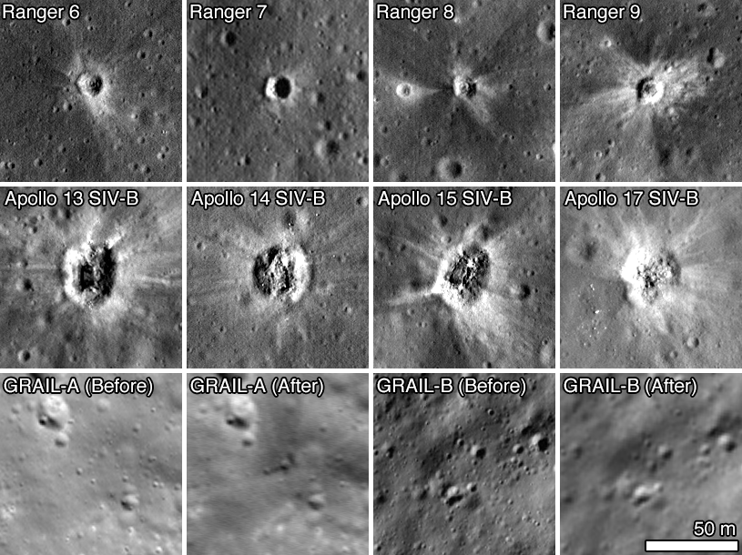
Selection of spacecraft impact sites imaged from LRO using the LROC twin Narrow Angle Camera instrument, all at the same scale [NASA/GSFC/Arizona State University].
Careful retracing of the Lunokhod 2 traverse dramatically improved our understanding of the surface activities of that intrepid rover. In addition, by accurately determining the locations of the Luna 23 and Luna 24 landers, the LROC team determined not only how the Luna 23 spacecraft failed, but also that the Luna 24 sample was collected on the rim of a small impact crater, providing an explanation for the discrepancies that existed for the past three decades between samples and remote sensing of the Mare Crisium surface.

Check out a map of robotic spacecraft sites on the lunar surface, HERE.

(a) listing of coordinates (mean Earth/polar axis (ME) system) of ... Soviet and American robotic space hardware and craters produced through spacecraft impact (thus far) identified by the LROC Team can be download as an Adobe PDF file is available HERE.

ED NOTE: This is at least a partial update to "Coordinates of Robotic Spacecraft," released April 9, 2010.

To generate the list of observed latitudes and longitudes, we compiled a list of line and sample coordinates for the center of each object in each image. Each image was then initialized using the USGS Integrated Software for Imagers and Spectrometers (ISIS) software package, attaching the appropriate spacecraft position and pointing information, along with the GLD100 lunar shape model for elevation. ISIS routines were then used to compute the latitude and longitude of the spacecraft (or impact crater) in that image.

The LRO spacecraft positions on the list were provided by the latest cross-over corrected spacecraft positioning kernels provided by the LRO LOLA Team, with an orbital position uncertainty of 15 meters. Finally, temperature-corrected NAC camera kernels produced by the LROC team contributed to the high precision and accuracy. The coordinates listed in the table are statistical median from all of the images acquired before April 28, 2013 for a particular site.

Related Posts:
Apollo 12 at 43 Years (November 20, 2012)
Taurus Littrow Oblique (September 29, 2012)
Close-up on the lonely trail of Lunokhod-2 (September 17, 2012)
America's last unmanned lunar lander (September 7, 2012)
"Houston, Tranquility Base here" (August 28, 2012)
Scooping the Soviets (August 8, 2012)
Apollo 15 departs Hadley Rille Delta - 41 years ago (August 2, 2012)
Tranquility Base at high-resolution before Apollo 11 (August 2, 2012)
Ranger 8 impact on restored Lunar Orbiter LOIRP photograph (July 31, 2012)
"O! Say can you see, by the dawn's early light" (July 27, 2012)
New tool for exploring LROC images and Apollo landing observations (July 19, 2012)
Craters bear Lunokhod-1 officially named (July 3, 2012)
Astronaut's eye view of the Apollo 16 landing site (June 19, 2012)
Who discovered water on the Moon (June 1, 2012)
Will China deploy the first lunar rover since 1976? (April 30, 2012)
The discarded extension of the Ranger program, David S.F. Portree (April 30, 2012)
Orion, up close (April 24, 2012)
Forty years ago, 'a big ol' Navy salute' (April 21, 2012)
Forty years ago-Apollo 16 (April 21, 2012)
The Last Sampler: Failure, then Success (March 17, 2012)
Lunokhod-1 revisited, too (March 15, 2012)
Lunokhod-2 revisited (March 13, 2012)
Pinpoint Landing on the Moon - Apollo 12 (March 12, 2012)
How Young is Young? - Apollo 16 (March 9, 2012)
LROC's closest look yet at Tranquility Base (March 8, 2012)
Apollo 12 and its pinpoint landing in the Moon (March 7, 2012)
Follow the tracks - Apollo 15 (March 6, 2012)
From the second of two sequential, exceptionally low periapsis orbital passes, allowing the LROC team at Arizona State University to capture breathtaking views of the Apollo 16 landing site in the nearside Southern Highlands, LRO orbit 10950, November 6, 2011; LROC NAC M175179080, field of view 145 meters, released on the 40th anniversary of the lift-off from the Moon of the Young and Duke expedition, April 22, 2012 [NASA/GSFC/Arizona State University]

Just another crater? (December 13, 2011)
"Boy, that sure looks like Luna 9!" (December 3, 2011)
Cernan says China will be first back to the Moon (November 8, 2011)
Hadley Rille and the Mountains of the Moon (November 8, 2011)
The First Race to the Moon, David S.F. Portree (September 27, 2011)
On the run! - Apollo 14 (September 8, 2011)
New Views of Apollo 12 (September 8, 2011)
Apollo 14 at 25 cm per pixel (September 8, 2011)
Skimming the Moon (September 8, 2011)
LRO Briefing: Latest Close-Ups of Apollo Sites (September 6, 2011)
Low altitude views of Apollo released (September 3, 2011)
First Low Altitude Apollo 12 NAC Image (August 11, 2011)
Crash or Coincidence (July 22, 2011)
Surveyor 7 (February 12, 2011)
New View of Apollo 14 (February 4, 2011)

Surveyor 7: Our Fragile Lunar LDEF (October 27, 2010)
LRO analysis of LCROSS data proves essential (October 21, 2010)
LRO transitions from exploration to science (September 16, 2010)
Apollo 16, Footsteps Under High Sun (July 11, 2010)
Too brief an expedition to a lobate scarp (August 24, 2010)
Re-acquisition: Lunokhod-1 (April 27, 2010)
Apollo 16: 38 years on (April 21, 2010)
Retracing the steps of Apollo 15: Constellation ROI (April 17, 2010)
Value-added LROC (April 16, 2010)
A fundamental point on the Moon (April 13, 2010)
The part of Apollo 13 that made it to the Moon (April 12, 2010)
Coordinates of Robotic Spacecraft (April 9, 2010)
Ranger 9 (April 4, 2010)
Absentee ownership of Lunokhod-2 (April 1, 2010)
LOLA's Tycho and the Apollo era (March 28, 2010)
The first successful robotic sampler, Luna 16 (March 26, 2010)
Apollo 13 SIVB impact (March 23, 2010)
Surveyor 5: A Hole-in-One (March 21, 2010)
Surveyor 6 on the plains of Sinus Medii (March 21, 2010)
Luna 21 Lander (March 19, 2010)
Foot fall around Orion in the mid-day glare (March 19, 2010)
Lunokhod-1 and Lunokhod-2 (March 17, 2010)
The Soviet lunar sampling missions (March 16, 2010)
Alan Bean shares Apollo 12 with community college students in Iowa (March 9, 2010)

The largest of three Apollo lunar laser range reflectors (LLRR), deployed at Hadley Rille by Scott and Irwin of Apollo 15 in February 1971. The instrument is still an active, critical component of on-going experimental science, part of the effort to further constrain the measured distance to the Moon (to within 3 mm) in part determine "locality," if any, of the laws cosmological physics. AS15-85-11468 [NASA/JSC].
Triumph (and disappointment) of Apollo 12 (November 19, 2009)
High Noon over Apollo 11 on YouTube (November 14, 2009)
Midday on Oceanus Procellarum: Apollo 12 (November 5, 2009)
Apollo 12 Second Look: Midday on the Ocean of Storms (November 4, 2009)
Apollo 17 from 50 kilometers (October 28, 2009)
When bombing the Moon was a good idea (October 21, 2009)
Apollo 14 SIVB impact (October 8, 2009)
Lonely Sentinel Abides (October 1, 2009)
Surveyor 1: America's first soft lunar landing (September 30, 2009)
Tranquility Base: a better, second look (September 29, 2009)
Shadow on the Moon (September 24, 2009)
LROC zooms in on Apollo 12 and Surveyor 3 (September 4, 2009)
First Look: Apollo 12 and Surveyor 3 (September 3, 2009)
Lasting boot prints from 1971 (August 21, 2009)
Trail of Discovery at Fra Mauro (August 19, 2009)
The continued importance of lunar laser ranging (August 3, 2009)
Rediscovering Tranquility Base (July 19, 2009)
Five Apollo landing sites photographed (July 17, 2009)
Lunar Orbiter III-154-H2 (LOIRP) (June 16, 2009)
LOIRP recovers early image of Ranger 8 impact (June 9, 2009)
Kaguya to impact June 10 (May 21, 2009)
Chang'e-1 controlled impact in Mare Fecunditatis (March 1, 2009)
More astounding detail (Surveyor 1) from LOIRP (February 26, 2009)
Anniversary of Ranger 8 (February 20, 2009)
Surveyor proved the Moon safe for man (January 4, 2009)

Chandrayaan-1 Moon Impact Probe shoots Shackleton (November 15, 2008)
Tranquility Base from Kaguya (SELENE-1) (March 29, 2008)

Tuesday, March 27, 2012

1000 Day Anniversary of LROC Imaging

Rim of Shackleton crater near the lunar South Pole as seen in the first LROC Narrow Angle Camera (NAC) image of the Moon, acquired on June 30, 2009. Image field of view is 850 meters across, NAC frame M101013931, orbit 72, resolution 99 centimeters per pixel from 42.96 kilometers. View the full size Featured Image HERE [NASA/GSFC/Arizona State University].
Samuel Lawrence
LROC News System

Today marks the one thousand day anniversary of LROC imaging from lunar orbit. Since 30 June 2009, LROC has acquired a total of 750,000 images: of these, 140,000 are WAC images and 440,000 are NAC images of the illuminated Moon (the remainder are night or space calibration images). So far the NACs have imaged about 40% of the Moon. NAC and WAC images will play a key role defining where human and robotic explorers will go to unravel many remaining mysteries of the Moon and inner Solar System.

A look back - After the launch of LRO on 18 June 2009, Science Operations Center (SOC) operations at ASU commenced immediately, with the SOC monitoring the status of the instrument as our personnel supporting launch operations at the Cape Canaveral Air Force Station flew back to Phoenix. The first images we collected with the LROC system a few weeks later were actually engineering test images to ascertain hardware functionality, and most importantly, show how well the focusing of the NACs was proceeding. Why? Because the Narrow Angle Cameras (NAC) telescope structures were built out of carbon fiber, they absorbed atmospheric water vapor, which caused the carbon-fiber to expand. In effect, the NACs were built out-of-focus in the laboratory, with the knowledge that the water vapor would be driven out of the structure in space and thus shrink. Careful engineering by Malin Space Science Systems (MSSS) ensured that the shrinkage was just enough that the optical elements would move into position and the cameras would be in focus. Exposure to the vacuum of space and decontamination heaters built into the camera drove the moisture from the carbon fiber, thus bringing the cameras into focus in about two weeks.

The first LROC images were collected on 30 June. We started to commission the LROC instruments over the Fourth of July weekend in 2009. I think I can speak for the entire LROC team at ASU when I say that there is no better way to celebrate the Fourth of July than by commissioning an American spacecraft in lunar orbit. Working for any NASA spaceflight mission, especially one that is leading the way towards returning Americans to their rightful place on the lunar surface, is and always will be a special honor and a privilege for those fortunate enough to get the opportunity to contribute.

Lunar South Pole, on the rim of Shackleton Crater, with it's permanently shadowed interior at upper left. Press release image, September 2009 [NASA/GSFC/Arizona State University].
We were pleasantly surprised when our pre-launch estimates turned out to be a bit conservative, and our first pictures were completely in focus. I will always remember the thrill of seeing that first image come up on the screen, proving that everything we had been working on for several years was functioning. The LROC team promptly released many pictures of the lunar surface in the following few days. Today's Featured Image is a look back at our very first image of the Moon, which appropriately enough shows the rim of Shackleton crater, one of the current highest-priority sites for human exploration. Why is Shackleton so interesting? Small portions of its rim are nearly continuously illuminated while its interior is perpetually in darkness. The dark areas harbor a treasure trove of volatiles (water) that can be harvested to support future lunar explorers, provide important clues to the history of volatile materials in our Solar System, and enable voyages to Mars and beyond.

Lunar South Pole, low resolution version of first NAC pair overlaid and outlined on a WAC basemap. Note that the WAC mosaic was built up over a month, and during that time the sun azimuth reversed, resulting in an interior to exterior illumination discontinuity on the rim of Shackleton crater [NASA/GSFC/Arizona State University].
The Adventure Continues - We have since acquired other images of not only Shackleton, but many other sites on the Moon, providing the data that NASA and other space organizations worldwide require to facilitate scientific discovery, safe landing site selection, and resource assessment. In fact, we have mapped more than 40% of the lunar surface with the NACs since launch. The LRO mission is showing no signs of slowing down and LROC continues to enable new science results that are redefining our knowledge of the Moon. After entering the stable frozen orbit several months ago, LRO has enough fuel for at least another five years of operations, and our overriding goal on the LROC team is to map the whole Moon with the NACs before the end of the mission. We have mapped the Moon globally with the LROC WAC over 28 times. Each WAC global map was acquired with different lighting, thus providing a powerful multi-temporal tool to unravel the physics of light interactions with planetary surfaces.

LROC data have thus far enabled major advances in our understanding of lunar volcanism, impact processes, lunar tectonics, and the lunar environment, and the discoveries have just begun. The lunar science and exploration communities will be analyzing LROC data for decades to come.

The LROC team is proud of the work we have accomplished thus far, excited for the discoveries yet to be made, and feel privileged to contribute to America's first steps on the road back to the Moon. The LROC team at ASU is eager to make the next 1000 days of LROC operations as rewarding, exciting, and productive as the first 1000 days have been. The Moon, with its incredible bounty of exploitable resources, stunningly beautiful vistas, and incredibly compelling scientific questions, continues to beckon us towards the next horizon.

Take a look at the full frame of the first LROC NAC image of the Moon, HERE.

Wednesday, March 7, 2012

LROC: Pinpoint Landing on the Moon (Apollo 12)


Descent and landing of Apollo 12 in Oceanus Procellarum, November 1969.

The Apollo 12 landing site (3.0119°S, 336.585°E) in Oceanus Procellarum, imaged during the second LRO low-altitude campaign, orbit 10,987, November 11, 2011. Field of view width = 225 meters, LROC Narrow Angle Camera (NAC) observation M175428601R  View the full size LROC Featured Image HERE [NASA/GSFC/Arizona State University].

Samuel Lawrence
LROC News System

The LRO mission continues to collect observations that are enabling ground-breaking new scientific discoveries about the Moon. As geologists, whenever we look at remotely sensed data collected from another planet, in a sense we are staring back in time. But this is the “deep time” of geology, where we are trying to understand natural processes that (at least on the Moon, anyway) could have happened billions of years ago. But the LRO mission is unique because we can also see human history. Not just any history, either, but one of humanity's greatest accomplishments, our first steps on another world. Twelve astronauts explored the lunar surface, directly seeing things with their own eyes, making observations, and collecting samples with their own hands. These samples and observations revolutionized our understanding of our solar system.

This “snapshot in time” effect is especially evident at the Apollo 12 landing site in Oceanus Procellarum, now known as Statio Cognitum. Here, you can see the remnants of not one, but two missions to the Moon. Astronauts Pete Conrad and Alan Bean demonstrated that a precision lunar landing with the Apollo system was possible, enabling all of the targeted landings that followed. Bean and Conrad collected rock samples and made field observations, which resulted in key discoveries about lunar geology. They also collected and returned components from the nearby US Surveyor 3 spacecraft, which landed at this site almost two and half years previously, providing important information to engineers about the how materials survive in the lunar environment.

Annotated low altitude LROC NAC image of the Apollo 12 landing site (view the glorious 2438 x 2109 image HERE). The informal names of craters visited by the astronauts, the positions of the ALSEP, Intrepid descent stage, and Surveyor 3 spacecraft are highlighted. LROC NAC M175428601R [NASA/GSFC/Arizona State University].
In the image above, you can see the remnants of the scientific experiments the astronauts set up on the surface, the first long-term Apollo Lunar Surface Experiments Package (ALSEP).  Powered by a Radioisotope Thermoelectric Generator (RTG), the ALSEP included a seismometer to record "moonquakes" and several experiments designed to make measurements of the lunar environment, including a Solar Wind Spectrometer, a Cold Cathode Ion Gauge, and a Suprathermal Ion Detector (see if you can find each piece of hardware). The Apollo 12 ALSEP returned data and measurements to Earth for over seven years following the mission and was turned off in September 1977. From the lower altitude you can pick out the shadow of the still standing flag, the High Gain Antenna (HGA), and the discarded Portable Life Support System (PLSS) backpacks.

Apollo 12 photograph of the ALSEP central station, with Intrepid and S-band High Gain Antenna (HGA) in the background. The ribbon cables in this image are clearly visible in the first low-altitude LROC image of the Apollo 12 landing site, below [NASA high-resolution photograph AS12-47-6928].
After deploying the ALSEP, the astronauts moved to the northwest, eventually stopping to take a series of photographs of the crater dubbed “Middle Crescent”. The boulders the astronauts observed on the surface are visible in the LROC image above.

Apollo 12 photograph of the interior of Middle Crescent crater, taken during the first Apollo 12 EVA [NASA high-resolution photograph AS12-46-6838].
During the second EVA, the astronauts performed a geologic traverse on foot covering almost 1.5 km. In today’s image, you can clearly follow the path they took edging around Head crater, proceeding to Bench and Sharp craters with a brief stop at Halo crater, visiting the Surveyor spacecraft, and then returning to the Lunar Module.

Apollo 12 photograph of the interior of Sharp crater taken by astronaut Pete Conrad, whose shadow you can see in the lower right [NASA high-resolution photograph AS12-49-7271].
One of the most common questions prior to the launch of LRO was: will you be able to see the American flags that were left on the Moon by the astronauts? The flags themselves are too small to be seen by the NACs, even with the small pixel scales enabled by the low-altitude orbit.  However you can see the shadow being cast by the flag. This is especially evident in this movie [15 MB Quicktime file] of LROC images of a complete lunar day, shown sequentially from dawn to dusk. Watch the rotation of the shadows carefully, and you can see the shadow cast by the flag! Question answered, yes you can find the flag - but what does it look like? Have the stars and stripes faded? That question will remain for a future landed spacecraft.

LRO was placed in low periapse orbits during two months last year: 8 August 2011 to 6 September 2011 and 31 October to 27 November 2011. In each month, LROC was able to obtain low altitude images of the Apollo 12 site. For comparison, the first low-altitude image is shown below. When this image was acquired, the Sun was 54° above the horizon (early-afternoon) and in today's Featured Image the Sun was 45° above the horizon (mid-morning). Incredibly, you can even see the ribbon cables connecting the ALSEP instruments to the central station in this first low-altitude Apollo 12 image (below). The cables appear as bright, straight lines leading from the SIDE and LSM, and are visible because, despite being narrower than the 25-cm pixel scale, they are highly reflective.

First NAC low altitude image of Apollo 12 site, larger area version linked below [NASA/GSFC/Arizona State University].
Forty-two years ago, using technologies that many people today would probably (and erroneously) find hopelessly antiquated, the crew of Apollo 12 executed a flawless precision landing  on another world. Imagine how much more today’s astronauts will accomplish when we return to the Moon with 21st century technology!

Explore the Ocean of Storms in our newest NAC observation, and be sure to check out this YouTube video showing the Apollo 12 landing site:


Other LROC Images of the Apollo 12 Landing Site:
First Look: Apollo 12 and Surveyor 3
Apollo 12 Second Look: Midday on the Ocean of Storms
First Low Altitude Apollo 12 NAC Image

Saturday, December 3, 2011

"Boy, that sure looks like Luna 9!"

Fig. 1  Idealized Google Earth icon of Luna 9, the first soft-landing on the Moon (the first soft-landing anywhere other than Earth), February 3, 1966. The cartoon Russian spacecraft is pinpointed more than 30 kilometers northeast (8.0°N, 296.0°E) of an 'official' landing site (7.08°N, 295.63°E) because investigators say the 'official' coordinates place the lander well beyond the eastern rise, at left on the horizon above. That location doesn't appear to match the landscape seen in the panoramas returned to Earth. The object identified as a likely candidate, at 7.153°N, 295.630°, is less than 2.8 km north of the official coordinates, but at a notably higher elevation on that same rize, perhaps where fewer obstructions are to be found on the local horizon [NASA/USGS/JAXA/Google].
Joel Raupe
Lunar Pioneer

The problems encountered by the Russian Federation after the launch of Fobos-Grunt on November 9, when compared with the apparent ease NASA is experiencing, thus far, in getting Curiosity through the present Martian launch window, might tempt fools to dismiss Russia's interplanetary skill. Russian morale might be threatened but we're reminded yet again that Space is relentlessly intolerant of cutting corners or under-funding. The Great Galactic Ghoul, that cosmic gremlin supposedly spoiling to ruin Mars and Moon missions alike, spends most of its time here on Earth.

Off-planet, when Institutional Memory is applied efficiently, the Russians are a match for anyone.

Friday, December 2 is the 40th Anniversary of the first soft-landing on Mars, and Russia's Mars 3 lander was successful, though the lander operated on the surface only 20 seconds, back in 1971. Saturday, December 3 is the 12th Anniversary of the loss of America's Mars Polar Lander in 1999. Thus, the success of Curiosity is by no means a sure thing. When space exploration begins to look too easy disaster waits patiently at the door.

A planned Russian return to the lunar
surface may ultimately benefit from a post-
Fobos-Grunt shakeout
[RussianSpaceWeb].
The first vehicle soft-landed on the Moon (and the last one landed there, a decade later) were strictly Made in Russia. Embarrassing and often tragic, spectacular failure also often fuels political will, without which governments accomplish nothing.  After a latter-day purge of Russia's unmanned mission contractor NPO Lavochkin, the legacy of Fobos-Grunt may help guarantee eventual success for Luna-Grunt and the other lunar missions Russia has in the works.

If all goes well, beginning next month, the United States will support five spacecraft exploring the Moon simultaneously, the most prominent among them the record-smashing LRO. Following decades of a near total neglect of its hard-won and expensive lunar legacy, America owes a revival of interest in Earth's Moon directly to the loss of Columbia in 2003.

An early priority for LRO was a survey of human artifacts on the Moon. Delivering spectacularly on that assignment were Mark Robinson, principle investigator for the Lunar Reconnaissance Orbiter Camera (LROC), together with his team at Arizona State University. Their most newsworthy success, quite naturally, were many high resolution history-making photographs of the relics and footprints from the Apollo program.

Fig. 2  Planitia Descentus - Latin for Plain of Descent, a human distinction for an otherwise indistinct borderland along the western edge of Oceanus Procellarum, where Luna 9 came to a tilted stop February 3, 1966.  The yellow dot on the rise at center bottom on both maps makes the location of an object that could be Luna 9. These comparative maps of the same 14,300 square kilometer area (centered near 8.48°N, 64.47°W) are (top) LROC WAC DTM  juxtaposed with (bottom) LROC WAC mosaic, each from LROC/ASU QuickMap (250 m/pp resolution). [NASA/GSFC/Arizona State University].
A steady stream of LROC Narrow Angle Camera (NAC) views were released during the LRO Nominal Mission revisiting the remains of a host of U.S. and Soviet spacecraft, both impact craters and the intact sentinel spacecraft themselves following hundreds of lunar days and nights. Each of these Featured Images released by LROC has fired the imagination while calibrating and confirming some very old, often incomplete sets of data.

Finding Lunokhod 1 (38.316°N, 324.996°E), for example, was an overdue accomplishment. It was the first robotic rover on another world, equipped with a laser range reflector that had eluded detection for decades. Its addition to the passive network of reflectors set up by Apollo 11, 14 and 15, together with its French-built twin on Lunokhod 2 allowed the measuring of the Earth-Moon distance to within 3 mm, the missing tolerance needed to test whether a range of physical laws were exclusive to our neighborhood in the universe.

A compendium of LRO's definitive findings, LROC Coordinates of Robotic Spacecraft, put together by Samuel Lawrence at ASU, was released April 5, 2010.

Though the list has not been updated since, it's still spectacular. For the first time, for example, anyone with an Internet connection can see precisely what happened when the third stage of the Saturn V that pushed Apollo 13 around the Moon impacted with the lunar surface. And planetary scientists have a precise date on a fresh impact crater on the Moon, as well; a standard useful for dating optical maturity and space weathering. We no longer have to imagine if the footprints are still there and decades of doubters can precisely see for themselves how the astronaut's surface photography matches the landscapes as seen only 45 (and more recently 25) kilometers away.

Still, the table put together by Lawrence can't yet be comprehensive.

A search for the place where Luna 2 became the first man-made object to impact another world in 1959, for example, is fraught with uncertainty. Those official coordinates are necessarily wide of mark, if only because the precise location of the Moon itself, and its surface, would never again be less well understood than before the Russian measured the time of impact for Luna 2.

A search for Luna 2 using those rounded-off coordinates brings the investigator west of Autolycus, to a 22 square kilometer area where there are at least two, perhaps three, fresh craters with the proper wispy signatures. One of them shows signs of a unique debris field, perhaps dotted with a cluster of the impact-resistant Soviet flag-engraved metal balls reportedly loaded on Luna-2. A surface expedition will be needed, in other words. As amazing as it is, however, even the LROC Narrow Angle Cameras have their limits.

At the very edge of those limits is Luna 9, the 99 kg.lander the Soviets succeeded in soft-landing on the Moon on February 3, 1966. In Multiple NAC footprints covering the target area uploaded to the Planetary Data System, even by April 2010, it was easy to see the LROC team had already earnestly tried to find that historic relic. But Luna 9 wasn't on the list put together by Lawrence.

Fig. 3  A closer look at the Plain of Descent.  The rectangle matches a 2.5 km-wide cross-section of LROC NAC observation M137970706R, the area seen in Figure 6a, below. The small white dot marks a spot less than a kilometer south of the rectangle, the official Luna 9 landing site, and the white dot inside the rectangle marks the location of an "object of interest," something that seems to be a Luna 9, in the two NAC observations detailed below.  The 'mid-morning' view above is a 41-km-wide field of view taken from LROC Wide Angle Camera (WAC) observation M160376850C (604 nm), LRO orbit 8769, May 18, 2011; incidence angle 55.42° with a resolution of 57.55 meters per pixel, from an altitude of 40.49 km [NASA/GSFC/Arizona State University].

As noted expert on lunar artifacts Phil Stooke of the University of Western Ontario put it, finding the very first vehicle soft-landed on the Moon was "problematic," even with the proven sensitivity of the twin LROC Narrow Angle Cameras. 

There is lingering dispute about the true landing site, though the central difficulty in finding Luna 9 is probably the small spacecraft's low profile. Its instrument housing is barely at the half-meter limit to the LROC NAC Nominal Mission resolution. And, because discussing Luna 9 without seeing its mission in the context of the Cold War would be incomplete, a brief comparison with Surveyor, its very real competition, is necessary.

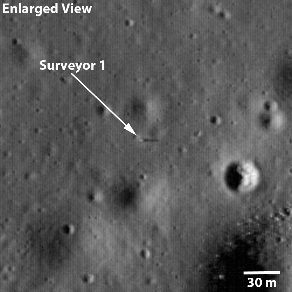
The Russians beat Americans to the Moon in 1966 by only five months. Samuel Lawrence had already written up and released LROC's first views of "Surveyor 1 - America's first soft lunar landing," on September 30, 2009. That observation (M102443995L) swept up the first U.S. lander very early in LRO's Commissioning phase, in orbit 272, when LRO was still flying at twice its Nominal mission altitude, from 102.4 km overhead. That survey of the floor of Flamsteed P was photographed at less than half of the planned LROC NAC resolution; at 1.08 meters per pixel, the Surveyor 1 tripod in profile was barely visible, identifiable mainly in its long shadow at local sunset.The Surveyor design featured a central mast with square solar panels at the top, standing high like a flag. That aided in identifying all five of the successful Surveyor landers, right they sat. 


Unlike its Google Earth icon, seen in Fig. 1, Luna 9 was not standing like an egg, balanced on one hemisphere. After its landing and activation Luna 9 was at tilted, and from slight changes in the background seen in its five photographic panoramas we can tell Luna 9 shifted slightly after deployment.

Fig. 4  Simulated oblique view west by northwest over the area of interest from a point 28 km over the western Oceanus Procellarum. After years of deconstructing the five panoramas captured and returned to Earth by Luna 9, many reliable experts have come to doubt the accuracy of the official landing site (coordinates on the left, at "-1310 m" elevation).  Some believe Luna 9 must have landed somewhere in the plain to the north (on the right, marked "-1640 m").  If the object detailed in Figures 5 and 6 below is Luna 9 then the lander came to rest at a point less than three kilometers and almost due north of the official coordinates ("-1170 m"), and at least 140 meters higher in elevation.  After studying the LROC WAC Digital Terrain Model of the area (Fig. 2) the hills, contiguous with other features surrounding the Plain of Descent, appear to be the highly degraded rim of an ancient, mostly buried crater.  -Image created using ILIADS application, developed by NASA's LMMP project; photography from LROC WAC Global Mosaic with elevations from LOLA altimetry (v.2). [NASA/GSFC/ARC/LMMP/ASU].
The low profile and squat, efficient design of Luna 9 have made it difficult to definitively locate, either somewhere in the expansive plain to the north or near the official position somewhere on a 500 meter high hill, nor on their slopes. All of the area was extensively photographed from LRO, from high altitudes and low, under high Sun and low Sun, with LRO rolled and looking down from directly overhead. If the little vehicle has been captured (which seems certain) what would distinguish its egg shape from thousands of boulders more or less the same size?

It's a safe bet Samuel Lawrence and others on the LROC team encountered this difficulty head-on, with the determination and resourcefulness of a Cold War photo-analyst pouring over U2 photographs of Cuban missile sites. 

In fact, it would be the height of presumption on our part to claim to have done anything more than retraced their steps. It's impossible to believe a candidate object we stumbled on, within their choices of photographic session, hasn't already been considered or scratched off the list. Were it not for something that may turn out to be simply an artifact of digital compression we wouldn't take another look.

Let's just say, "boy, that sure looks like Luna 9!"

What follows are two sets of images, selected from two separate LROC NAC observations, focused on an "object of interest" at sunrise (Figures 5a and 5b), when the Sun was less than 5 degrees over the east horizon, when long shadows allow for depth perception, and then (in Figures 6a - 6d) where, at less than 8° north of the equator, the Sun was high overhead and depth perception gives way to a search for subtle variations in brightness or optical maturity.


Fig. 5a   The full 2.5 kilometer-wide field from LROC NAC M132071202L orbit 4597, June 25, 2010; with resolution greatly reduced from the original 0.48 meter per pixel resolution captured from 40.49 km altitude, incidence angle 85.57°. The yellow rectangle is the area shown at full resolution in Fig. 5b, immediately below. The yellow dot is our "object of interest," so to speak, indicated with an arrow in at full resolution below. The object certainly casts a shadow, as anything with a profile would when caught in naked morning sunshine on the Moon. It is also seemingly brighter than other similarly sized objects in the roughly 238 meter-wide field of view seen below.  [NASA/GSFC/Arizona State University].
Fig. 5b  Full resolution, and very non-definitive rendition of the Object of Interest, again, from LROC NAC M132071202L The object appears to be situated within the west slope of a 10 meter crater, whose interior is very darkened with shadow. Since Luna 9 arrived on the Moon not long after local sunrise, this doesn't help identify the object as Luna 9. The larger, similarly bright object to the southwest is too large to be Luna 9, but its size and location relative to the object of interest makes a case for it being part of the larger lander bus [NASA/GSFC/Arizona State University].
On the 500 meter hills, south of "the plain of descent," under an afternoon Sun:

Fig. 6a  Backing away once again, shifting perspective slightly to the west, with the Sun nearly overhead, this is the field of view within the rectangle back in Fig 3, and slightly west, overlapping the area in Fig. 5a, another 2.5 km-wide area taken this time from LROC NAC M137970706R, orbit 5466, September 1, 2010, from 45.57 km in altitude (incidence angle 29.64°). The area in the white rectangle is the field of view enlarged in Fig. 6b, immediately below [NASA/GSFC/Arizona Sate University].
Fig. 6b  At 40 percent of their original resolution, line 14775 to 15556 by sample 3964 - 4544 from M137970706R. (The dim dark line is an artifact "junction" between line 15000 and 15001). And, like a Russian Doll, the square box above is the roughly 290 meter-wide field of view seen at 100 percent of the original observation's 0.5 meter per pixel resolution seen in Fig. 6c, immediately below [NASA/GSFC/Arizona State University].
Fig. 6c At full resolution, lines 15001 - 15580 by sample 3964 - 4543 from LROC NAC M137970706R. Compare this with Fig. 5b, above and, once again, what is seen under differing lighting conditions on the Moon is clear. When happening upon this candidate object under a high Sun, something catches the eye [NASA/GSFC/Arizona State University].
Fig. 6d  Taking  LROC NAC M137970706R  well beyond its true limit of resolution we stumble upon what might be Luna 9, resting on the west interior slope of a shallow 10 meter crater, perhaps even afterwards sliding slightly between photographic panoramas, February 3, 1966. Under an early afternoon Sun, after being enlarged 400 percent with a super-sampling algorithm, what appear faintly as three of the spacecraft's four instrument-shielding petals (the fourth presumably in its shadow) somehow popped out from the background. No intentional fudging was done to the original brute-force enlargement (See Fig. 7) [NASA/GSFC/Arizona State University].
Fig. 7 A simple enlargement to 400 percent of the half-meter per pixel resolution native to LROC NAC observation M137970706R turned up this object, certainly an oddity if it is not Luna 9. As demonstrated in the hackneyed animated image (Fig. 6d), the object meets the profile, is barely less than 3 kilometers due north of its official landing site, about 140 meters higher in elevation, on a broader slope with presumably less obstructed horizon.

Fig. 8 The view south from Luna 9, February 3, 1966.


Using the popular open-source program Orbital Simulator, "reseferina1" created this interesting simulation of the Luna 9 mission in 1966. Though fun, it too, unfortunately, made the thing look far too easy. The originating YouTube page is HERE.

Tuesday, November 8, 2011

Hadley Rille and the Mountains of the Moon

NASA Lunar Reconnaissance Orbiter (LRO) rolled to capture a dramatic oblique view of the Apollo 15 landing site 26.1°N, 0.25°E on the plains of Hadley Rille Delta. Hadley Rille, a great chasm in the lunar surface, carves through the center of this scene. Explore the full size LROC image HERE. LROC Narrow Angle Camera (NAC) observation M165842369, orbit 9574, July 20, 2011 [NASA/GSFC/Arizona State University].
Samuel Lawrence
LROC News System

On 20 July 2011 (coincidentally, the 42nd anniversary of the first steps humans took on another world) the NASA Lunar Reconnaissance Orbiter was commanded to roll to the east, allowing the Lunar Reconnaissance Orbiter Camera to obliquely observe Hadley rille and the Apollo 15 landing site. One of humanity's greatest voyages of exploration, the adventures of mission commander David Scott, lunar module pilot James Irwin, and command module pilot Al Worden transformed our understanding of the Moon and the Solar System. The shadow of the descent stage of the Lunar Module Falcon is visible, as is that of NASA's first lunar roving vehicle. Additionally, the sampling stations explored by the Apollo 15 astronauts are easy to pick out.

Full scope of the LROC NAC oblique frames detailed HERE. Hadley Rille is about 1.2 km wide. The whole scene is 28 kilometers from left-to-right [NASA/GSFC/Arizona State University].
Apollo 15 was the first of three long-duration “J-missions”; more would have flown had the Apollo program not been brought to a premature conclusion in 1972 after the Apollo 17 mission. The J-missions featured heavily instrumented command and service modules, improved spacesuits to promote crew agility, upgraded lunar landing vehicles, and the electric Lunar Roving Vehicles (or LRVs) to expand the crew's range on the surface. Prior to the mission, the Apollo 15 crew received extensive geoscience training, which (along with the increasingly capable hardware) resulted in an extraordinary bounty of scientific results. Apollo 15 was also the only lunar mission where all crewmembers were graduates of the University of Michigan and United States Air Force officers (the lunar module, Falcon, was named after the mascot of the United States Air Force Academy, and the Apollo 15 command module Endeavour is now on permanent display at the National Museum of the U. S. Air Force in Dayton, OH).

LROC NAC mosaic from M170538271, sampled at 2 meter pixel scale (from the original 0.5 m) showing area where lunar sample 15555, "Great Scott," was collected (Station 9A) west of the Apollo 15 landing site. View the larger original 2 meter image prepared for this essay HERE [NASA/GSFC/Arizona State University].
Astronauts Scott and Irwin spent almost three days exploring the Hadley-Apennine valley, traversed over 28 kilometers (17 miles) using the first lunar rover, and collected over 77 kilograms (170 pounds) of priceless lunar materials, including the famous “Genesis Rock”, a piece of the primordial lunar crust. While Scott and Irwin explored the surface, command module pilot Worden used the extensive instrument suite aboard the command module Endeavour to successfully complete a complex series of orbital observations. You can view digital scans of the original Apollo 15 flight films taken by Endeavour's Fairchild Mapping Camera at the Arizona State University Apollo Digital Image Archive! 

The geologically complex Apollo 15 site is a high priority target for future human lunar exploration, and consequently was one of the Constellation Regions of Interest that were a focus of LROC observations during the LRO Exploration Systems Mission Directorate mission (the 1st year of LRO operations). Thanks to the exploration of the Apollo 15 astronauts, we now have a well-defined set of scientific questions that can only be addressed through a future human sortie mission to the Hadley-Apennine region. In addition, recovering materials from the descent stage of Falcon would provide valuable information to present-day engineers about how materials survive on the lunar surface for long periods of time.

Edge of Hadley rille where lunar sample 15555 (Station 9A) was collected, August 2, 1971. The disturbed soil at 9A are the foot prints and LRV tracks left by Scott & Irwin, 40 years ago, testifying to the intensive study and sampling at this site. See the larger image prepared for this essay, from an observation not due for release until December, HERE [NASA/GSFC/Arizona State University].
On Saturday, November 5, as part of the School of Earth and Space Exploration's annual Earth and Space Exploration Day, Arizona State University unveiled a display featuring a piece of Apollo Lunar Sample (ALS) 15555, a mare basalt collected by Col. Scott about 12 meters from the rim of Hadley rille at Station 9A. This lunar rock is the largest and one of the most intensively studied samples collected by the Apollo 15 astronauts, and is predominantly composed of silicate minerals such as olivine, pyroxene, and plagioclase. The bulk composition of 15555 is thought to represent a primitive volcanic melt and has been used for experimental and theoretical studies related to the geologic origin of lunar basalts. Planetary scientists use information gleaned from such analyses to gain key insights into how terrestrial planets like the Moon and Earth form and evolve. Sample 15555 has also been used for critical tests designed to help perfect and calibrate methods of radiometric age dating employed by different laboratories around the world.

On their third EVA, before sampling 15555, Col. Scott took a picture of its location and immediately handed the camera to Jim Irwin, who then captured a series of shots for a standard panorama of Station 9a. The three legged gnomon was placed beside the sample so scientists could later determine its orientation of the rock on the surface [NASA, AS15-82-11164].
What is a mare basalt and what is its significance? The lunar mare basalts are very similar to terrestrial basalts. If you drove up to Sunset crater outside Flagstaff AZ, you can find basalt. If you go to Hawaii, Iceland, India, Ethiopoa and many other countries you can find basalt. The oceanic crust on the Earth is composed of basalt. If you visit Mars you will likely land on basalt or basalt derived sediments. If you land on Venus - same! The Dawn spacecraft is right now orbiting an asteroid, Vesta, that is composed of basalt. Basalt is common in the Solar System. The fascinating fact about basalts is that they represent a sample of the upper mantle. We can't get to the mantle directly, but nature provides us with samples of the deep interior (mantle) in the form of basalt. Volcanism is the delivery truck! Since the mantle makes up most of the mass of the Earth, Mars and the Moon we must have samples of the mantle to understand each body as a whole. You can think of 15555 as a piece of the Moon's interior, even though it was picked up on the surface.

Apollo Lunar Sample 15555 on display at the Lunar Reconnaissance Orbiter Camera Science Operations Center [E. Speyerer, Arizona State University].
A generous loan to Arizona State University from the NASA Lyndon B. Johnson Space Center, this 76 gram (2.7 ounces) piece of mare basalt will be displayed in the Lunar Reconnaissance Orbiter Camera Science Operations Center Visitor Gallery. This stunning and unique lunar sample display will enable visitors to view and learn about an amazing piece of our Moon, while just a few meters away, behind a glass partition, the LROC team is sending commands to LROC and receiving images in return that enable scientists and engineers to plan for future human and robotic exploration of the Moon.

We heartily encourage anyone interested in space exploration to come view this priceless American treasure and learn how lunar scientists around the world are pioneering your future in space. The work we do at LROC is tremendously exciting, but ultimately, it is the human passion for discovery that drives this enterprise.

Explore the complete NAC oblique image of the Hadley-Apennine valley!


Visit the LROC Science Operations Center

Read more about the Apollo 15 landing site
in previous LROC Team posts
:

Layers Near Apollo 15 Landing Site (30 August 2011)
Retracing the Steps of Apollo 15: Constellation Program Region of Interest (16 April 2010)
LROC's First Look at the Apollo Landing Sites (17 July 2009)
Lunar Highs and Lows (22 July 2008)
The Mighty Apennine Mountain Range (30 September 2008)
Hadley-Apennine: the Apollo 15 Landing Site (14 November 2007)

Further Related Posts:

40th Anniversary of Apollo 15 celebrated at Kennedy Space Center
Al Worden award with Moon Rock
Kaguya captures Hadley Rille

Hadley Rille Valley of Palus Putredinis on the Imbrium side of the Apenninus mountain ridge, 1971 landing site of the Apollo 15 expedition. LROC Wide Angle Camera (WAC) mosaic from 7313 and 7314, January 24, 2011; resolution 53 meters, incidence angle 65.77° from 36.36 kilometers [NASA/GSFC/Arizona State University].