Wednesday, July 31, 2013

Melted Moon

Click for full resolution LROC mosaic
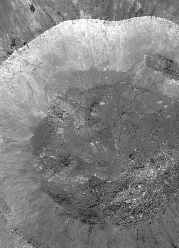
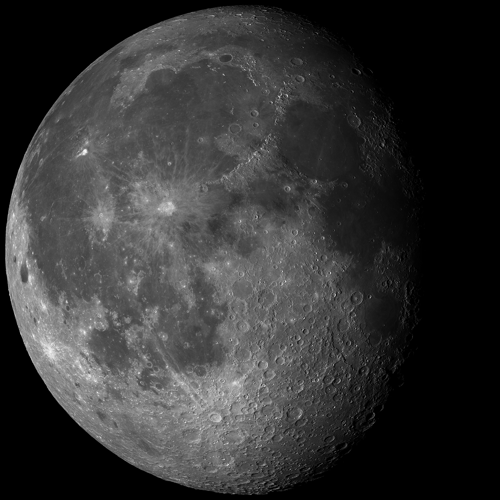
The fresh lunar crater Giordano Bruno -a wealth of fascinating landforms to study. (click image for full resolution view, or HERE for a wider, medium resolution field of view showing the entire crater) [NASA/GSFC/Arizona State University].
Paul D. Spudis
The Once and Future Moon
Smithsonian Air & Space


Prior to the Space Age, one of the longest running controversies in lunar science was over the origin of the Moon’s craters.  Two camps emerged, one favoring an internal (volcanic) origin and the other an external (impact by solid bodies) origin.  Although this debate was finally resolved in favor of impact, the argument was long and vehement, reigniting at one point during the flight of the last of the robotic precursor probes to the Moon, prior to the Apollo landings.  Although the basic physics of impact were well understood by the mid-1960s, this newest argument centered around high-resolution pictures obtained by Lunar Orbiter 5 (1967) of the fresh (and therefore young) crater Tycho.  These spectacular images showed a multitude of flows, smooth ponds, and fluid rock, seemingly draped over hills and hummocks (like a chocolate shell coating over a scoop of ice cream).

An asteroid possesses an enormous amount of kinetic energy when it strikes a planetary body at very high speeds.  On contact, the asteroid vaporizes and the surface target rocks are intensely compressed.   After the shock wave has passed, these rocks decompress and the release of this energy totally melts part of the crustal target.  This material is said to be shock melted, with the resulting liquid called impact melt.  Impact melt was first described from craters on the Earth, particularly some of the very large impact craters found on the ancient Canadian Shield.  These rocks superficially resemble some volcanic rocks, having both fine-grained textures and partly melted inclusions.  But unlike volcanic rocks, they have high concentrations of siderophile (“iron-loving”) elements, such as iridium.  These elements are extremely rare in the Earth’s crust, but are more abundant in meteorites and asteroids.  It is thought that they are added to the melt from the incoming projectile.

The newest chapter in the argument about the origin of craters came about because some landforms around Tycho look similar to small-scale volcanic features on Earth.  The idea proposed was that the craters had been formed by impact, with those collisions triggering volcanic activity and producing multiple episodes of eruption at Tycho and other craters.  At first glance, such a scenario seems plausible.  After all, impact is a catastrophic event and one can imagine churning seas of subsurface liquid rock, released suddenly through the creation of fractures deep in the crust.  But the Moon’s interior is relatively cool.  If interior melt exists, it is at a level much too deep for any reasonably sized impact to tap.  But these amazing landforms needed to be explained.  What might they represent?

We found abundant physical and chemical evidence for impact (including shock-melted rocks) by studying the Apollo samples.  They appear similar to volcanic lava, with inclusions, melt textures and even vesicles (holes), comparable to the ones produced by magmatic volatiles coming out of solution in basaltic lavas on Earth.  Although it took a bit of study (and many more arguments) to establish their origin, shock melting became recognized as an important lunar (and Earth) impact process.

M160029952LR-109-1160x1600
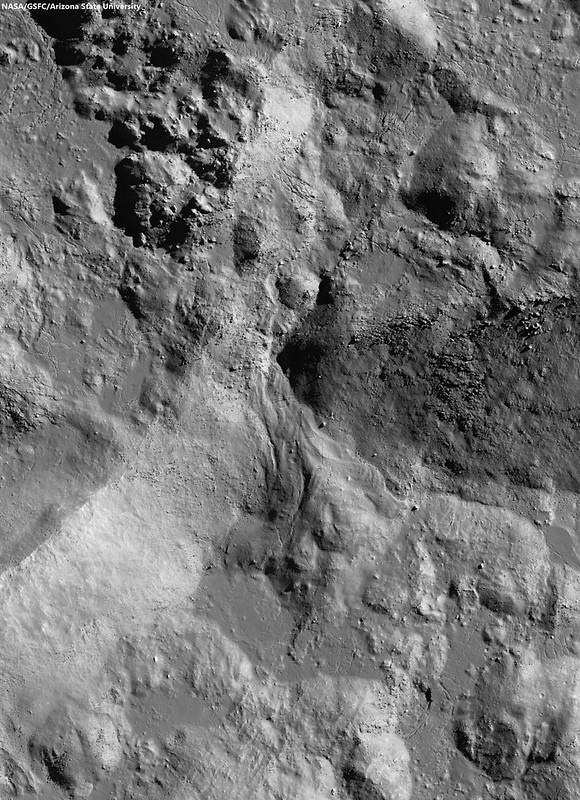
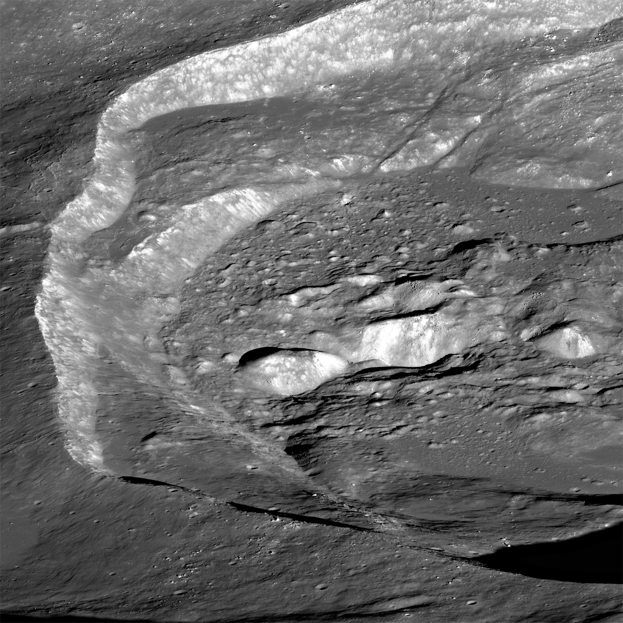
Breech in the northwest rim of Tycho connects to the spectacular melt ponds inside out outside of the 109 million year old landmark crater. Illustration originally from "Landing Site at Tycho North," March 20, 2013 [NASA/GSFC/Arizona State University].
The images of the flows and ponds seen around Tycho and other fresh lunar craters led to a better understanding of how these rocks formed.  Although we knew about impact melting from the study of Earth’s craters (and had found evidence of the same in lunar samples), some researchers still weren’t convinced that we were seeing flows of liquid impact melt on the Moon.  The leading non-volcanic alternative was that these features were flows of dry, fine-grained granular debris.  In part, this interpretation proceeded from the observation that the thermal signatures of some of these melt-like flows suggested the presence of fine debris rather than bare, jagged rock.  Yet other data, such as radar backscatter, suggested that rough surfaces were common, while extremely high-resolution images showed abundant blocky craters on the surfaces of the flows, suggesting they were composed of solidified rock.

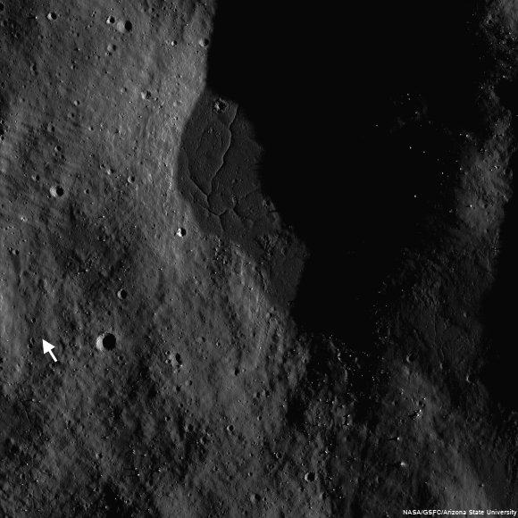
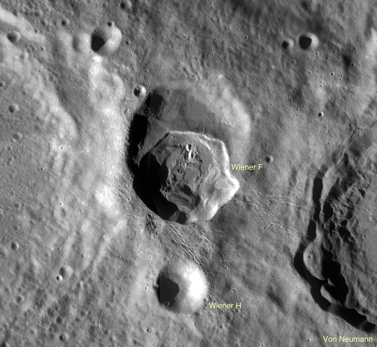
Landing site of Surveyor 7 (arrow) in relation to it's hoped for target, the kilometer-sized impact melt pond immediately to the northeast, part of the spectacular melt throughout the vicinity of Tycho [NASA/GSFC/Arizona State University].
Images from the robotic Surveyor 7 (1968) spacecraft, which landed on the rim of Tycho, revealed the thinnest regolith (soil) covering of any site on the Moon.  Visible in the surface panoramas were flow features covering the distant hills.  It took a great deal of painstaking, detailed work to establish that these flows and ponds were composed of liquid rock, created simultaneously with their host crater and likely originated by impact melting and subsequent solidification.

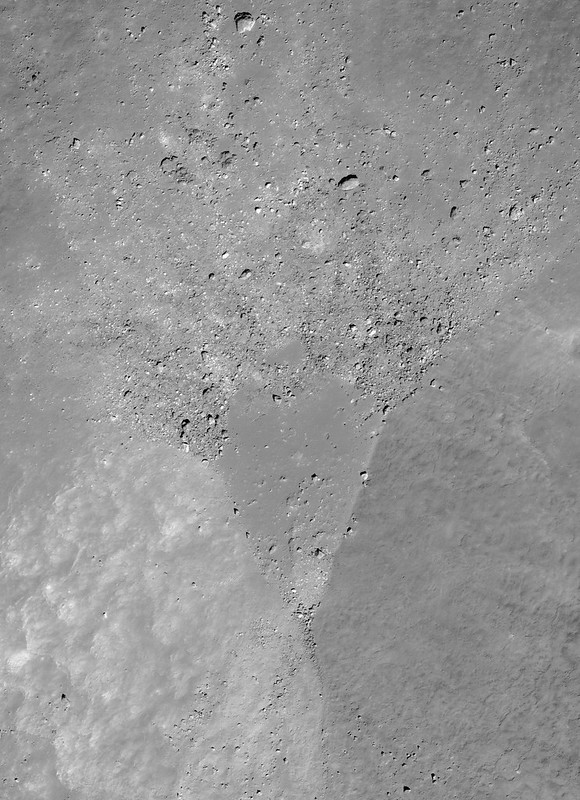
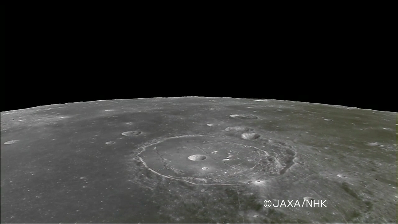
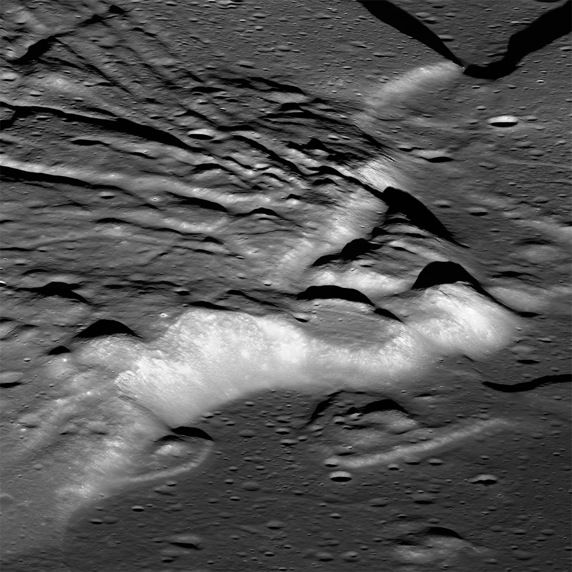
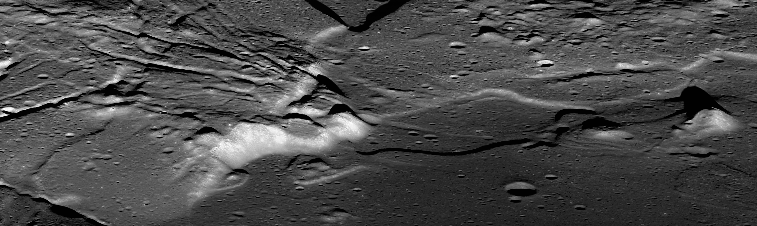
For the last several years, NASA’s Lunar Reconnaissance Orbiter (LRO) has been sending us new and astonishing views of the Moon’s impact melt flows.  Whereas fresh craters like Tycho, Aristarchus and Copernicus were well known from previous Lunar Orbiter frames, far side craters like the spectacular Giordano Bruno can now be seen with incredible clarity.  G. Bruno is one of the very youngest craters on the Moon.  A low density of craters overlying G. Bruno suggests an age of less than a couple million years (extremely young on a planet where most features count years in the billions).  It is an astonishing spectacle of melt shapes and deposits (cracked floors, pools, flow festoons and lobes); the crater floor has an amazing whirlpool of solidified melt. All these features indicate that after the crater formed, the impact melt was mobile, flowing and collecting, and ponding in low areas.

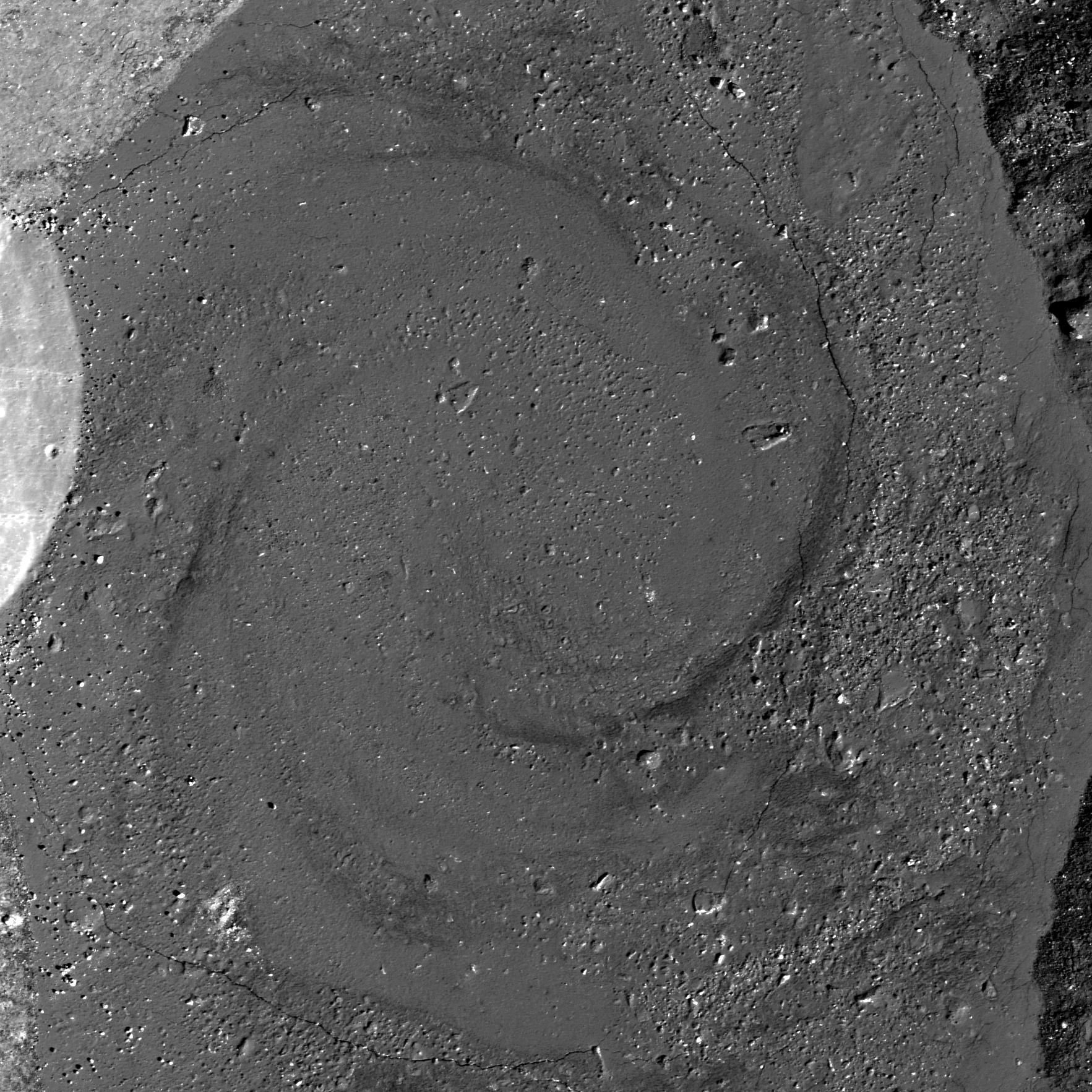
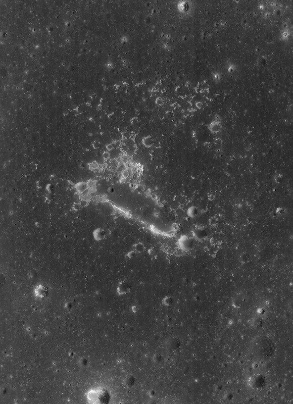
Impact melt forms a swirled feature in Giordano Bruno crater. Field of view 1 kilometer. From LROC Narrow Angle Camera (NAC) observation M143947267L LRO orbit 6347, November 9, 2010; 53.08° angle of incidence, 57 centimeters per pixel resolution from 54.50 km. Illustration from "Giordano Bruno Whorl," June 8, 2013 [NASA/GSFC/Arizona State University].
Impact melts are of great interest to geologists.  Unlike other crater ejecta, the radiometric clocks of impact melts are completely re-set by the melting.  Thus, if a sample can be obtained first-hand, directly from an observed flow or pool of melt around a host crater, the age of that rock specifically and unambiguously dates the impact event.  Unfortunately, we did not visit such deposits during the Apollo explorations.  What we do have are loose samples of lunar impact melt but not their scientifically important corresponding geological context.  It is for this reason that the age and sequence of early lunar history is so contentious – we must make educated guesses about where certain melt rocks come from.  If we get the context wrong, then our conclusions about the history of the Moon are incorrect.

Increased understanding of the generation and deposition of impact melt comes from the new images obtained by the LRO camera of the geologic setting of impact melts.  Future sample return missions to the Moon can be directed to landing sites that will provide us with samples of clear geological context (that they were from that area and not just flung there by an impact occurring elsewhere on the lunar surface).  As features age on the Moon, subsequent geologic events (such as superposition of new units) bury or erase the original event making the context less clear.  This problem is particularly acute for the oldest features on the Moon (multi-ring impact basins).  By studying the geology of the freshest lunar features (such as Tycho and other fresh craters), we understand how the older impact features looked immediately after their formation.  Thus, they serve as a guide to the interpretation of the older features.  On the Moon, as on the Earth, as Charles Lyell, the 19th century author of the classic Principles of Geology aptly put it:  The present is the key to the past.

Collection of spectacular impact melt features from LRO:
Giordano Bruno high-resolution full view
G. Bruno sunset
G. Bruno flows
G. Bruno cracked melts
Tycho oblique
Tycho floor
Tycho river of rock

Originally published July 31, 2013 at his Smithsonian Air & Space blog The Once and Future Moon, Dr. Spudis is a senior staff scientist at the Lunar and Planetary Institute. The opinions expressed are those of the author but are better informed than average

ESA prepares for LADEE

LADEE approaches lunar orbit
Artist's view of NASA's Lunar Atmosphere and Dust Environment Explorer (LADEE) observatory as it approaches lunar orbit [NASA].
An advanced laser system offering vastly faster data speeds is now ready for linking with spacecraft beyond our planet following a series of crucial ground tests. Later this year, ESA’s observatory in Spain will use the laser to communicate with a NASA Moon orbiter.

The laboratory testing paves the way for a live space demonstration in October, once NASA’s Lunar Atmosphere and Dust Environment Explorer – LADEE – begins orbiting the Moon.

LADEE carries a terminal that can transmit and receive pulses of laser light. ESA’s Optical Ground Station on Tenerife will be upgraded with a complementary unit and, together with two US ground terminals, will relay data at unprecedented rates using infrared light beams at a wavelength similar to that used in fiber-optic cables on Earth.

“The testing went as planned, and while we identified a number of issues, we’ll be ready for LADEE’s mid-September launch,” says Zoran Sodnik, manager for ESA’s Lunar Optical Communication Link project.

“Our ground station will join two NASA stations communicating with the LADEE Moon mission, and we aim to demonstrate the readiness of optical communication for future missions to Mars or anywhere else in the Solar System.”

Read the illustrated ESA article, HERE.

Laser from Optical Ground Station on Tenerife
ESA's Optical Ground Station (OGS) is 2400 meter above sea level on the volcanic island of Tenerife, in the Canary Islands. Visible green laser beams are used for stabilizing the sending and receiving telescopes on Tenerife and neighboring La Palma. The OGS facility is utilized for extensive experiments with entangled photons, quantum communication and teleportation. OGS is also used for standard laser communication with satellites, tracking space debris and finding new asteroids. The image above includes Tenerife's Teide volcano with the Milky Way in the background [ESA/IQOQI Vienna, Austrian Academy of Sciences].

Tuesday, July 30, 2013

Orientale Sculpture

An oblique view of ejecta over 400 km south of the Orientale basin rim, a scene approximately 5 km across, centered at 51.8°S, 264.8°E, LROC Narrow Angle Camera (NAC) mosaic M1127819355LR, LRO orbit 18355, July 7, 2013; native resolution 1.9 meters per pixel [NASA/GSFC/Arizona State University].
Brett Denevi
LROC News System

Today's featured image is located near the center of the ancient 600-km Mendel-Rydberg basin. Its degraded state means Mendel-Rydberg's presence is not obvious in the WAC context image below (in fact, its existence was only confirmed with Clementine (1994) topography data), but its western rim is near the crater Mendel, and Rydberg and Guthnick craters are near the center of the basin.

However, it was not the Mendel-Rydberg impact that was responsible for the ups and downs in the hummocky deposits seen in today's Featured Image, but the Orientale impact event, hundreds of kilometers away to the north.

Ejecta from impact basins is both erosional, gouging out long valleys and leaving strings of large secondary craters (along the arrows in the image below), and depositional, blanketing even distant terrain with material excavated from the impact site. Basin ejecta plays such a large role shaping the lunar surface that these ups and downs are often referred to as "basin sculpture," and the ejecta from Orientale certainly sculpted the terrain in today's image.

LROC Wide Angle Camera (WAC) mosaic context views of the southern Orientale region. The blue box in the image at bottom shows the field of view at top, where a yellow box shows the approximate field of view shown in the LROC Featured Image. Click to enlarge [NASA/GSFC/Arizona State University].
The hummocky deposits that cover low-lying areas in the top image, and the image below, are likely ejecta from the Orientale basin. These low-lying regions may have once been exposures of smooth mare basalt, some of which is still exposed on the surface in nearby regions, but are now hidden under a blanket of debris from Orientale. Buried volcanic deposits such as these are known as "cryptomare" and tracking down the locations of these ancient sites of volcanic activity is key for understanding the extent of early volcanism on the Moon.

A wider (and reduced-resolution) view of the LROC NAC mosaic from which the LROC Featured Image within the Mendel-Rydberg basin was cropped. LROC NAC M1127819355LR [NASA/GSFC/Arizona State University].
You may also note that the hills in the southern portion (right side) of the image above have a lumpy texture, also visible in the WAC context image. This is also likely due to Orientale's influence - the result of a massive ground hugging flow of ejecta that piled up on the sloped terrain. This oblique view of the region gives a great perspective on its complex history that would have been compelling enough with just the ancient Mendel-Rydberg basin and early lunar volcanism, but the spectacular basin ejecta flows captured here are just icing on the cake (so to speak).

Click HERE to see the full-resolution view.

Related LROC Featured Images:
Amazing Orientale Peaks and Valleys
Regolith Patterns in Mendel-Rydberg
Window to the Farside Mantle
Two-toned Impact Crater in Balmer Basin: A reflection of the Target?
Dark Craters on a Bright Ejecta Blanket

Thursday, July 25, 2013

Snapshots from the Moon and Cislunar Space

Apollo 17 commander Eugene Cernan (UR, LR), CM pilot Ron Evans (UL, LR) and LM pilot and geologist Harrison "Jack" Schmitt (LL) relaxing in the Apollo 17 Command Module America after Cernan and Schmitt returned from three days of exploring the magnificent Taurus Littrow valley, the last manned expedition to the lunar surface 40 years ago, December 1972 [NASA/ Arizona State University].
Mark Robinson
Principal Investigator
Lunar Reconnaissance Orbiter Camera
Arizona State University

This year, we commemorate the forty-fourth anniversary of the first human lunar landing. By now, the whole world is very familiar with the high-quality Hasselblad snapshots taken by the Apollo astronauts during their voyages. However, 35-mm cameras were also carried on some of the Apollo missions for both surface and orbital imaging. Most of the surface 35-mm images are extreme closeups of the lunar regolith from the Apollo Lunar Surface Closeup Camera (ALSCC; Apollo 11, 12, 14); sometimes called the Gold Camera after its Principal Investigator Thomas Gold.

The Nikon camera used on board the Apollo Command Module was equipped with a 55-mm lens and was loaded with either black-and-white or color film. During Apollo missions 16 and 17, black-and-white film was used for dim-light photography of astronomical phenomena and lunar surface targets illuminated by Earthshine. During Apollo 17, color film was used for documenting various activities in the Command Module.

The 35-mm frames are now scanned as part of a joint project between Arizona State University and the NASA Johnson Space Center to scan all of the original Apollo flight films.

Boot print anaglyph - Stereo anaglyph (get out your red-blue stereo glasses!) AS14-77-10369a,b from the ALSCC showing extreme detail of an astronaut bootprint in the fine-grained lunar regolith. The original field of view is about 3 inches on a side [NASA/Arizona State University].
The Apollo 17 crew seems to have had the most fun with the 35-mm format! Gene Cernan, Ron Evans and Jack Schmitt snapped quite a few spectacular black-and-white images showing the view out of the window of their Command Module, the America. Some of these images are a bit grainy, resulting in a very different feeling than the crisp Hasselblad photographs. They also took numerous color candid shots inside the Command Module. It is rare to see such carefree moments during the Apollo missions, but you can feel the relief and happiness after the astronauts so successfully fulfilled their surface mission!

Reiner Gamma illuminated solely by earthshine (35-mm Apollo 17) - Reiner Gamma, one of the enigmatic lunar swirls; their origin is related to localized magnetic fields within the crust AS17-158-23894 [NASA/Arizona State University].
Many of the window shots present an oblique view across lesser known regions of the Moon. The terminator (boundary between night and day) scenes are always captivating. Look closely at the scene below; near the center is a shallow-sloped scallop-shaped rise. Just below and to the right are two other smaller rises - perhaps these are low shield volcanoes? You can dig deeper by visiting the LROC QuickMap browser and see if the NAC images can elucidate what is seen here (Natasha crater is at 19.973°N, 328.843°E).

Mare Imbrium meets Mare Procellarum (Apollo 17 35-mm frame) a complex region composed of nearly buried peaks that are part of the Imbrium rim, impact craters, and volcanic forms. Annotated AS17-160-23992 [NASA/Arizona State University].
Relive the incredible adventure that was Apollo, browse the Apollo 35-mm archive and the rest of the Apollo scans (Metric, Pans; Hasselblads to follow next year). While browsing, map out your own next mission to the Moon! The hard part is figuring out where to visit next. Enjoy!

Related Posts:
Project Mercury Photography Now Online
Project Gemini Comes to Life
Reiner Gamma Constellation Region of Interest
Mare Ingenii Swirls

Tuesday, July 23, 2013

The View Inside a Tilted Crater

Oblique view of the chaotic interior of 30-km Wiener F crater. LROC Narrow Angle Camera (NAC) mosaic M1113262343LR; LRO orbit 16307, January 19, 2013, spacecraft and camera slewed 52° west from 160.39 km over 41.84°N, 140.28°E, subsampled from a scaled 2.78 meter per pixel resolution. Scene width approximately 13 kilometers from left to right, centered at 41.1°N, 150.0°E. [NASA/GSFC/Arizona State University].
Brett Denevi
LROC News System

Impact melt is commonly found in and around fresh lunar craters and can be spotted as ponds, flows, and ejecta.

This oblique view of the farside crater Wiener F highlights one of the more spectacular examples of what happens to the melt when a crater forms on a slope.

In the image above, you have a great perspective view of the chaotic crater interior, where material slumping into the crater interacted with the fluid melt, creating rough, hummocky mixtures in some regions and smoother pools of melt in others. But what is really interesting about this crater becomes clear when you zoom out to the full width of the image, below.

Thumbnail view of LROC NAC mosaic M1113262343LR, looking from west to east into Wiener F crater. For the full-resolution, zoomable view click HERE [NASA/GSFC/Arizona State University].
Wiener F formed atop a larger, older crater, so its northern rim, on the left in the picture above, ended up substantially lower than the southern rim. A profile across the crater, taken from the GLD100, shows the northern rim of the crater is over 2 km lower in elevation than the southern rim!

A profile from south to north across crater Wiener F, taken from LROC WAC-derived topography data [NASA/GSFC/Arizona State University].
So tilting the crater like this is like tilting a glass of water - it spills. In this case, the hot impact melt that would normally stay within the crater poured out, spilling over the northern rim and pooling outside the crater. Click on the image below to see this spectacular flood. You can find individual flows and places where the melt was still moving even as a crust of hard rock formed on top, resulting in cracks and wrinkles in the top layer.

View of the impact melt that escaped Wiener F, pooling outside the northern crater rim. Image subsampled from the original resolution [NASA/GSFC/Arizona State University].
Impact melt is a favorite target for LROC imaging because of its often complicated and bizarre features, and because of what it tells us about the impact process. The volume of melt can give clues as to how fast an impactor hit the surface (higher velocities mean higher shock pressures and more heat to melt rock), at what angle it impacted (melt is often thrown downrange of an impact), and how long ago the impact occurred (by observing how well preserved the melt morphology is, or by age-dating a sample of melt). Impact melt can also give insights into how portions of the crater moved and settled as the crater formed (for example, how did melt get up HERE?).

LROC Wide Angle Camera (WAC) contextual view of Wiener F crater, nested in the Farside Highlands [NASA/GSFC/Arizona State University].
Wiener F is another piece of that puzzle, showing what a dynamic environment an impact crater is shortly after formation. Click HERE for the full-resolution view of Wiener F.

Other Spectacular
Impact Melt Favorites:
Rumker E Impact Melt
Dynamics of Molten Rock
La Pérouse A Impact Melt
Rippled Pond
Breached Levee
Secondary Melt on the rim of Wiener F
Getting cracked in Wiener F
Giordano Bruno Whorl

Small-Scale Volcanism on the Lunar Mare

LROCWAC-small-shield-volcanism-1314
"Small Shield Volcanism on the Lunar Mare," (figure 1.) EPSC 2013-875 Plescia, Robinson & Joliff. Constructs in Mare Tranquillitatis. a: low-relief, low-slope with central crater; b "pancake-shaped"; c and d': hummocky, steep-sided , gc: ghost crater. LROC Wide Angle Camera high-angle incident mosaic, centered near 7.5°N, 37.5°E [NASA/GSFC/Arizona State University] .
Plescia, Robinson & Jolliff
Johns Hopkins APL
Arizona State University
Washington University of St. Louis


"Small shield volcanoes having low relief and gentle slopes are scattered across the lunar mare. These features represent the terminal phases of mare volcanism and are formed by short-duration, low-volume eruptions. Composition and eruption dynamics may have varied as the morphology and color of the shields vary. There appears to be regional correlations of morphometric properties indicating larger-scale organization of the eruptions.

"Data from LRO and other missions now provide the ability to characterize each dome in terms of areal extent, topography, morphology, and color properties in unprecedented detail allowing for an analysis of their origin.


"Here, a subset of the domes are interpreted to represent a volcanic style characterized by small volume eruptions that built low-relief constructs (Fig. 1). This style of volcanism has been termed plains volcanism [14] and is common in the Tharsis region."

Small Shield Volcanism on the Lunar Mare, European Planetary Science Conference 2013, Vol. 8, #875; J.B. Plescia, Johns Hopkins University Applied Science Laboratory; M.S. Robinson, Arizona State University; B. Jolliff, Washington University, St. Louis

M190351657L-NSJ-0503-6509x8978
Small-scale shield volcanic vent structure ("d." in WAC mosaic above) south of Rupes Cauchy in Mare Tranquillitatis, near 7.5°N, 37.5°E; Vent strongly presents features resembling those of the Ina structure. 6.2 km-wide field of view from LROC NAC mosaic M190351657LR, LRO orbit 13098, April 29, 2012; 41.95° angle of incidence, resolution 0.95 meters per pixel from 113.33 km. Full-size versions HERE [NASA/GSFC/Arizona State University].

Friday, July 19, 2013

An observation post on the rim of Posidonius

M157391825RL-M172717111LR-58b-2431x3354-level
Deep interior of an unnamed Copernican crater (30.363°N, 30.705°E) notched on the south rim of Posidonius, the 95 km pre-Imbrium crater on the northeast edge of Mare Serenitatis. The slope of the impact zone and angle of attack resulted in a triangular melt pond at the exposed center. Photograph from a mosaic of mosaics stitched from four overlapping LROC Narrow Angle Camera (NAC) frames taken 177 days apart (M157391825RL and M172717111LR), field of view 1160 meters, resolution 48 cm [NASA/GSFC/Arizona State University].
Joel Raupe
Lunar Pioneer

Posidonius (95 km, 31.878°N, 29.991°E) is a well-known floor-fractured crater, and a grand sight even through small telescopes in early evenings before First Quarter or before dawn, four days after a Full Moon. It is also an enduring crater, a remnant of the Moon's surface before the basin-forming impacts creating Mare Serenitatis, Mare Crisium and Mare Imbrium.

With regard to the oldest of these three basin, Serenitatis, Posidonius clings to its inundated northeastern edge, carrying scars from each of these epoch-changing events as well as the continuous gardening of subsequent lunar bombardments, both large, small and microcosmic. 

A kind of ready-made construction site for an observation post is notched into the north-facing.southern wall of Posidonius, very near the rim, and it features more than just an excellent view of the southern interior of the ancient crater. In terms of superposition and strategraphy this "improvement," in the form of a relatively recent small Copernican age crater may also be an observation post into the Moon's deeper past and the history of our star system.

A full-resolution sample of the mosaic of mosaics shows a a straight contact between the wall and floor of "30-30" crater. The left (west) side of the 272 meter field of view shows part a flat triangular melt zone, with an upslope on eastern wall. If the crater's progenitor impacted in a relatively flat plain, presumably the contact would have been the border of an encircled melt pond. LROC NAC M172717111LR, LRO orbit 10587, October 8, 2011; 34.21° angle of incidence, resolution 47 cm from 39 kilometers [NASA/GSFC/Arizona State University].
"30-30" crater, informally named for its location near 30°N, 30°E (30.363°N, 30.705°E), is a bright and distinctive two kilometer notch excavated on Posidonius' wall, near the top of its south-southeastern wall, a result of a relatively recent impact in the past half-billion years or so, a youngster in the neighborhood and on the lunar timescale.

The oldest, or at least deepest, material a lunar impact tosses out ends up on the crater's rim. So this small younger impact did future geologists a service. Efficiently, "nature's dynamite" excavated material originally thrown up and out from the Posidonius impact event and, as luck would have it, ejecta from Chancornac, also a pre-Imbrium crater to the southeast and more or less sharing the same rim.

The interior and east side of "30-30," shows small intriguing exposures of "dark halo" material on the crater's east wall and deposited with it's southeastward ejecta. LROC NAC M172717111LR [NASA/GSFC/Arizona State University].
The entire region is characterized by intriguing hints of underlying features in addition to its more obvious scars from disrupting shocks. Posidonius and its vicinity are deeply faulted, its floor scoured, inundated and subsequently drained of catastrophic lava flows and was clearly, on more than one occasion, subject to energies powerful enough to buckle its underlying floor.

A distinctive sinuous rille circumscribes the interior wall of Posidonius pointing to a rapid disbursal of.heated flows into Serenitatis at some point in its busy past.

Old Posidonius is at a crossroads in space, between crater-saturated highlands and the deeper plains of Lacus Somniorum and Mare Serenitatis, and it also sits at a crossroads in time, being older than Serenitatis and carrying some of the same history as the Sculptured Hills near the landing site of Apollo 17, 300 km to the south.

To get below these scars to sample the material originally tossed up by Posidonius in the dim past, before Serenitatis we would need to dig its its rim. Fortunately, the progenitor of "30-30" already did the digging.

A thumbnail, very much a miniature 580 pixel-wide reduction of the 9600 sample-wide "mosaic of mosaics" high-resolution and finely detailed survey of the "30-30" excavation of the ancient rim of Posidonius. LROC NAC mosaic of M172717111LR and the overlapping NAC observation swept up 177 days earlier, M157391825LR, from LRO orbit 8329, April 14, 2011; 35.35° angle of incidence, 48 cm per pixel resolution from 41.18 km [NASA/GSFC/Arizona State University].
As "the Rosetta Stone of the Solar System," the Moon is a history of bombardment (in the inner Solar System and, more importantly for us, in the vicinity of Earth) at a frequency and magnitude supposed to have steadily fallen off from its beginning roughly 4.575 billion years ago. A question as enduring as Posidonius, perhaps, is whether the rate of this bombardment might once have increased for a time, perhaps as a consequence of a disrupting shuffle in the orbits of the outer planets somewhat "late" in our star system's history, within its first billion years. 

"LROC Quick Map" quick look at a three dimensional model of a 27 km-wide area of the lunar surface around the "30-30" crater on the south-southeast rim of Posidonius, derived from WAC global surveys [NASA/GSFC/Arizona State University/DLR].
From the Real Estate trade we borrow the all-encompassing Latin word Situs, familiarly translated (outside strict legal circles) as "location is everything," or "location, location, location." Though "30-30" may not perhaps be uniquely situated, it may, if little else at this point, illustrate one way to determine the relative value of places on the Moon as they might be chosen for their value to science.

The dramatic disruption inside Posidonius, even the bright "30-30" crater itself, can distract the eye away from deep fractures nearby. Note a long fault line running south away from the rim of Posidonius, easily mistaken for a photographic artifact. A 34 km-wide field of view from LROC Wide Angle Camera (WAC) monochrome (566 nm) observation M159752877C, LRO orbit 8677, May 11, 2011; 53.58° incidence angle, resolution 58.8 meters from 42.28 km [NASA/GSFC/Arizona State University].

"30-30" itself presents to us a fairly average Copernican crater, for its size, though its location (there's that word again) perhaps more than its progenitor's angle of attack, caused it to end up presenting an atypical interior.

Instead of a round interior melt pond, or disk of impact melt at the center, the melt at the exposed center of "30-30" ended up triangular, making it into a flat balcony on Posidonius' south wall. It's essentially missing north has left the triangular melt pond to the mercy of steady erosion, shedding boulders and other fine, bright material down onto the slumped terraces of Posidonius' walls.

It's bright ejecta is marked in a few places by a definitely darker material, what might be an exposed layer or vein of dark halo material or even cryptomare half-way down the small crater's southeast wall. Additionally, there are at least two patches of perhaps this same darker material to the small crater's southeast and southwest, on its "normal" ejecta.

All in all, what else has the "30-30" crater "dug up?"

M159-8675-79-CE_566nm-58b-2104x2902
A broader context view of Posidonius (our crater of interest hugging to a "Five O'Clock" position on its rim. The fault proceeding south from Posidonius' rim is readily seen, as a crack through Chacornac that seems almost contiguous with a long crack in floor of Posidonius. LROC WAC mosaic stitched from surveys over five sequential orbits from about 42 km on May 11, 2011 [NASA/GSFC/Arizona State University].
HDTV-Posidonius-Rimae
Japan's lunar orbiter Kaguya (SELENE-1) captured Posidonius, together with the bright "30-30" crater on it's south-southeast rim in this HDTV still of eastern Mare Serenitatis from polar orbit in 2007 [JAXA/NHK/SELENE].

Sunrise across Posidonius and the environs of northeastern Mare Serenitatis, early evening viewing before First Quarter Moon here on Earth.  Those with an anatomical eye can see the lucky location of "30-30" crater and its excavation.
Related Posts:

Meanders in Posidonius (February 13, 2013)
Geological mapping of another world (January 25, 2013)
Rimae Posidonius (December 1, 2010)

Wednesday, July 17, 2013

A Unique View of the Moon

Nearside LROC WAC Reflectance - The Sun overhead, across the whole Moon! Of course this is not possible in real life, but 36 nearly complete WAC mosaics make this view possible [NASA/GSFC/Arizona State University].
Mark Robinson
Principal Investigator
Lunar Reconnaissance Orbiter Camera
Arizona State University

A huge payoff from the longevity of the LRO mission is the repeat coverage obtained by the LROC Wide Angle Camera (WAC). The WAC has a very wide field-of-view (FOV), 90° in monochrome mode and 60° in multispectral mode, hence its name. On the one hand, the wide FOV enables orbit-to-orbit stereo, which allowed LROC team members at the DLR to create the unprecedented 100 meter scale near-global (0° to 360° longitude and 80°S to 80°N latitude) topographic map of the Moon (the GLD100)! However, the wide FOV also poses challenges for mosaicking and reconstructing lunar colors because the perspective changes plus- and minus-30° from the center to the edges of each frame. The problem lies in the fact that the perceived reflectance of the Moon changes as the view angle changes. So for the WAC, the surface appears to be most reflective in the center of the image and less so at the edges, which is quite distracting! This effect results in a pole-to-pole striped image when making a "not-corrected" mosaic.

No photometry WAC mosaic  - Large area WAC mosaic illustrating reflectance differences due to 30° change in view angle from the center of a WAC frame to each edge (without photometric correction). Mosaic composed of around 30 WAC orbital image strips [NASA/GSFC/Arizona State University].
What to do?

Easy - simply take 36 nearly complete global mosaics (110,000 WAC images) and determine an equation that describes how changes in Sun angle and view angle result in reflectance changes. Next step, for each pixel in those 110,000 WAC images compute the Solar angle and the viewpoint angle (using the GLD100 to correct for local slopes), and adjust the measured brightness to common angles everywhere on the Moon. For this mosaic the LROC Team used the 643 nm band, a Solar angle 10° from vertical (nearly noon), and a viewing angle straight down. Well, perhaps easy is a bit of an exaggeration!

Imagine the number of pixels to consider! To reduce the computational load we use only a subset of the pixels to fit. The most challenging aspect is determining the best photometric model for this huge dataset. Using existing knowledge of lunar reflectance, many iterations, and a variety of classes of mathematical solutions, we ended up using a combination of output from a least-squares fit on a linear model as starting parameters to a minimum search algorithm on a non-linear model. This technique adds robustness to the non-linear model and enables us to more quickly converge on a solution. Or in other words, there were a lot of calculations over many starts and restarts. So perhaps the process was not that easy in practice, but in the end, it was successful! This type of study is known as photometry, and has a rich history going back to the first half of the 20th century.

Four Views of the Moon - from the new WAC 643 nm reflectance mosaic. Upper left: nearside (0°N, 0°E); Upper right: eastern hemisphere (0°N, 90°E); Lower left: farside (0°N, 180°E); Lower right: western hemisphere (0°N, 270°E) [NASA/GSFC/Arizona State University].
With the Sun overhead, topography variations are hard to see, but differences in albedo (relative reflectance) are enhanced. Look closely at the reflectance map (above) versus a version of the same map but with natural shading added back (using the WAC topography, below). In the purely reflectance map, mare (low reflectance) and crater rays (high reflectance) really stand out! The mare appear as they do because of their high abundance of iron (iron [Fe2+] in minerals such as pyroxene, and iron metal [Fe0] as a product of space weathering), and in many areas titanium (in the mineral ilmenite). Both elements are strongly absorbing in visible wavelengths. Crater rays are generally composed of the same materials upon which they rest, but they have not undergone as much space weathering, yielding a reflectance contrast. Space weathering lowers the reflectance over time, so just wait around a few hundred million years and watch Tycho's rays disappear!

WAC nearside reflectance shaded - WAC reflectance map with natural shading applied [NASA/GSFC/Arizona State University].
Stay tuned. Late this fall, full seven-color WAC mosaics will be available resulting from this same photometric solution. Read more on the empirical normalization process.

Related:
Large version of the nearside reflectance map, HERE.
Please view the spectacular rotation movie in HD (MOV) format, HERE.

Related Posts:
LROC WAC Global Topography (GLD100)
WAC Global Mosaic

Tuesday, July 16, 2013

Amazing peaks and valleys in new Orientale NAC oblique

Spectacular oblique view of the interior of the Orientale basin. LROC Narrow Angle Camera (NAC) mosaic M1124173129LR, LRO orbit 17842, May 26, 2013, centered at 24.23°S, 264.30°E. The scene cropped above shows a field of view approximately 16 km across, and the cliffs at center rise almost 2 km over the southwestern interior edge of the basin floor. Native resolution 2.59 meters per pixel [NASA/GSFC/Arizona State University].
Brett Denevi
LROC News System

With an estimated age of around 3.8 billion years, and a diameter of over 900 km, the Orientale basin is the youngest of the large lunar impact basins.

Its interior is relatively well preserved and its floor has not been completely buried under mare basalts, making it one of the most studied basins on the lunar surface in the hopes of unraveling the mechanics of multi-ring basin formation and the relationships of volcanic infilling to large basins.

Today's featured image highlights some of the more bizarre and complex features inside the southwestern portion of the basin, where primary features related to the basin itself meet the later-forming mare basalts in the basin floor.

Miniature (view the 1280x720 animation HERE) composition of five frames of HDTV captured by Japan's lunar orbiter Kaguya (SELENE-1) in November 2007.  In polar orbit more than 100 km over Mare Orientale Kaguya moves north. Beginning far to the south the slideshow begins with the inner mountain ring like a wide plateau looming on the horizon and minutes later the inner basin and lava-flooded basin floor comes prominently into view, including the area shown at high resolution in the LROC NAC oblique mosaic. Afterward, the final frames linger a moment over prominent Maunder crater and the high mountainous rings and valleys of north Orientale. Widespread terrain disruption by the basin-forming impact is uninterrupted throughout the entire sequence [JAXA/NHK/SELENE].
View the Kaguya Image Gallery HERE

A reduced-resolution version of the oblique NAC mosaic of the Orientale interior. The thumbnail above links to a 2470 by 740 reproduction HERE, while the zoomable, full-resolution view is viewable HERE [NASA/GSFC/Arizona State University].
The striking linear features seen in the top image are portions of a series of cracks that are near-radial to the basin and are unlike typical lunar graben. This portion of the interior is thought to have a high proportion of material that was melted by the extreme shock pressures of the impact event that crated the Orientale basin, and the cracks may have formed as the hot material, draped over underlying topography, cooled and shrank. It is hard to picture the effects of an impact so large it would have obliterated the state of Texas, but here you can almost see the molten and shifting terrain settling and cracking.

LROC Wide Angle Camera (WAC) context view of a portion of southwestern Orientale basin featuring the approximate area shown in NAC mosaic (white box) M1124173129LR [NASA/GSFC/Arizona State University].
You can also get a sense of how basaltic lavas, the lower-reflectance deposits seen at bottom right, poured in later, flooding low areas, lapping up against the higher-standing terrain, and leaving kipukas of original basin material exposed in some spots. These lavas are estimated to have erupted on the order of 100 million years after the formation of the Orientale basin, but were not as voluminous as the basalts that bury all but the rims of other lunar multi-ring basins, such as Serenitatis and Imbrium. The WAC image mosaic of the region, seen below, helps put these features into context. Here you can see the Orientale mare deposits lie largely within the innermost ring of the basin, the Inner Rook mountains. (The other rings are named the Outer Rook mountains, also seen below, and the Cordillera mountains, which lie outside of the context image.)

Why did these basalts fill regions largely contained within only the innermost ring of Orientale, whereas other basins were totally flooded? Orientale may have formed in a region of thicker crust, making it harder for basalts to erupt from the mantle to the surface anywhere but the center of the basin, where the crust was thinned the most. The composition of Orientale's basalts is also known to be different from the major nearside maria, with a lower concentration of radioactive heat-producing elements (known as KREEP), so there may have been less heat available to melt the mantle to produce basalts.


GRAIL MoonKAM video stills sequenced into nadir and off-nadir low-orbit HD views of Mare Orientale (2:00). The area of interest is visible between 1:05 and 1:15 [NASA/JPL-Caltech/Sally Ride Science].

This interplay of spectacular, complex features related to basin formation and later volcanic eruptions means Orientale is a high-priority target for exploration. Samples would pin down the exact age of the basin, important for answering questions about chronology across the Solar System, as well as answer a host of other questions about basin formation and evolution. And what a beautiful view you'd have, standing at the base of Orientale's cliffs!

View the full-resolution NAC mosaic of beautiful Orientale HERE.

Related LROC Featured Images:
Sinuous Cracks
Geologically recent debris flow at Couder
Orientale Basin
A digital terrain model of the Orientale Basin
Chain of secondary craters in Mare Orientale
Dark halo crater in Orientale!

Thursday, July 11, 2013

Lunar Kipuka

A ghost crater, breached and filled with the lavas of Mare Imbrium (31.364°N, 334.217°E), the 3.2 km field of view from LROC Narrow Angle Camera (NAC) observation M193132768L, LRO orbit 13487, May 31, 2012; 74.94° angle of incidence, resolution 1.46 meters from 147.07 km [NASA/GSFC/Arizona State University].
Brett Denevi
LROC News System

The lunar maria were once "seas" of highly fluid lava, and within their margins small islands and shorelines can be found. Today's featured image highlights a classic example of a partially flooded impact crater within Mare Imbrium. The western wall of the crater, a low point in the rim, was breached by the flowing lava, and the crater was filled nearly to its rim. What remains of the rim is known as a kipuka, the Hawaiian word describing an island of older land surrounded by younger lava flows.

The shoreline can be seen within the crater as a terrace-like ring just inside the crater rim, particularly on the eastern side. This terrace is akin to the high-water mark of a flood, and marks the high-lava point along the crater wall. As the lava cooled, it contracted and subsided to a somewhat lower level. Similar features are seen in areas like Bowditch, within Lacus Solitudinis.

The kipuka of interest, out on the vast plains of Mare Imbrium, in the 48 km-wide field of view of LROC Wide Angle Camera (WAC) monochrome (643 nm) observation M177798520C, spacecraft orbit 11338, December 6, 2011; 76.25° angle of incidence, resolution 60.03 meters from 43.97 km [NASA/GSFC/Arizona State University].
The flooded crater in today's image is approximately 2.7 km in diameter, and was likely originally around 500 m deep. That gives a maximum lava thickness of a little less than 500 meters in this spot, though that does not require a single 500-meter thick flow. Lava likely pooled in the low of the crater floor from multiple individual flows, rather than one massive influx of lava. Layering exposed within sinuous rillesmare pits, and impact craters suggests individual lava flows were much thinner (on the order of 10 meters).

LROC WAC context mosaic showing the location of the flooded crater (arrow) within an outline of the footprint of NAC M193132768L [NASA/GSFC/Arizona State University
Note the small (250 meters in diameter) high reflectance crater nearly in the center of this flooded crater. An astronaut could descend its interior and inspect a cross-section of about the top 25 meters of the basalts and determine the thickness and frequency of the lava flows that filled the host crater. The rim of this impact crater is the only kipuka preserved in the area, and is the last local remnant of the surface before it was drowned in the lavas of Mare Imbrium several billion years ago.

Browse the full-resolution NAC image HERE.

Related LROC Featured Images:
The Swirls of Mare Ingenii
Remnants of the Imbrium Impact

Tuesday, July 9, 2013

Surveyor Crater: Before and After

Another look at Surveyor Crater, the Apollo 12 and Surveyor 3 landing site, under early morning illumination not much above the horizon from what Conrad & Bean encountered after the second manned landing on the Moon in November 1969. (View the labeled LROC Featured Image release HERE,, and read a description for comparisons made between a high-resolution Lunar Orbiter photograph of the same area. Field of view above is 270 meters at this, the full 47 centimeter per pixel resolution; cropped from LROC Narrow Angle Camera (NAC) mosaic M177785917RL, orbit 11336, December 6, 2011; 73.1° angle of incidence from 38.15 kilometers [NASA/GSFC/Arizona State University].
Ryan Clegg
LROC News System

The Lunar Orbiter program, much like LRO, was designed primarily to obtain images to allow scientists and engineers to characterize the lunar surface in the context of finding safe and engaging landing sites for future missions.

A total of 5 Lunar Orbiters (LO) were sent to the Moon, and they collectively photographed most of the lunar surface at 60 to 600 meters resolution, with resolutions as high as 1 meter per pixel for some of the LO-5 photographs.

In 1967, NASA launched Lunar Orbiter 3 with the primary objective of finding safe landing sites for the Surveyor and Apollo missions. Both a Surveyor and an Apollo mission soon visited one area that the Lunar Orbiter photographed. Surveyor 3 landed on April 20, 1967 in Oceanus Procellarum at approximately 3.02°S, 23.42°W.

The spacecraft landed in a small, 200 m crater that was later named Surveyor Crater.

LOIRP3154H2-A12-paths-58b-1400x1931
Recovered from the original telemetry tapes by the Lunar Orbiter Image Restoration Project (LOIRP). LO3-154 H2 was recently released, including an inset marking the Surveyor 3 and Apollo 12 expeditions [LOIRP/Moonviews.com].
LROC image M1108432631R (left, incidence angle = 68.8 degrees) and Lunar Orbiter 3 image LO3-154-H2 (right, incidence angle = 67.2 degrees) of Surveyor Crater, the eventual landing site of both Surveyor 3 and Apollo 12. Both images were taken at similar illumination geometries and the NAC image has been stretched to match the saturation seen in the LO-3 image [NASA/GSFC/USGS/LPI].
The LROC NAC mosaic (bottom) and an similarly arranged field of view from Lunar Orbiter image 3154-H2 (top, incidence angle = 67.2°) of Surveyor Crater, eventual landing site of Surveyor 3 and Apollo 12 soon after.
Two and a half years later, on 19 November 1969, Apollo 12 demonstrated the Lunar Module's capability to make a pinpoint landing by setting down on the edge of Surveyor Crater, about 155 m from the deactivated Surveyor 3 spacecraft. Almost 45 years later, LROC imaged the same area of Oceanus Procellarum that LO-3 photographed. The LROC image, however, reveals some new features - the Apollo 12 Lunar Module (LM), Surveyor 3 spacecraft, and astronaut tracks are all visible. Perhaps most evident is that Surveyor Crater and the area around the LM are noticeably brighter than in the LO image.

AS12-48-7133HR
Apollo 12 cmdr. Pete Conrad poses by the Surveyor 3 unmanned spacecraft two and a half years after the small vehicle soft landed just inside the east rim of a 200 meter crater in Oceanus Procellarum, a deliberate test and demonstration of rapid advancements in precise landing navigation necessary for future landings. Conrad holds up the sampling arm and grasps the video camera assembly, both retrieved and providing valuable study of the effects of the dusty landing plume originating from Intrepid lunar module. Alan Bean snapped this picture. [NASA/ALSJ].
This increase in reflectivity resulted from effects of the rocket exhaust interacting with the regolith during the descent of the Apollo 12 Lunar Module. Directly beneath and adjacent to the LM the surface appears darker because the exhaust gas disrupted and roughed up the surface. However, a few meters away from the lander and extending outward for several hundred meters, the surface was altered in such a way as to make it more reflective, possibly a result of smoothing.

During the Apollo 12 descent, Pete Conrad flew the spacecraft around the edge of Surveyor Crater in order to get to the safe landing spot he wanted. The crater then likely acted as a mechanism to contain the rocket exhaust, causing the entire crater to experience disturbance and appear more reflective.

A pixel, and part of another (marked by the arrow) just barely shows the Apollo 12 lunar module descent stage profile, on the "shoulder" of "The Snowman" crater group, from 106.48 kilometers above a point on the lunar surface well to the east. The original resolution above 3.5 meters per pixel, May 31, 2012. LROC NAC frame M193067752R. (The long shadow of the mast of Surveyor 3 may just be visible as a small bump on the shadow line across the interior of Surveyor crater [NASA/GSFC/Arizona State University].
The full-width of LROC NAC frame from M193067752R, where a rectangle marks the field of view at 40% full resolution in the image immediately above, camera and spacecraft were slewed 60° off nadir, providing an unusual oblique observation. (Both this image abd the one referenced immediately above it originally used to illustrate the post "Apollo 12 at 43 Years," Nov. 20, 2012) [NASA/GSFC/Arizona State University].
LROC WAC context mosaic, with the location of Surveyor crater marked. Note proximity with the ejecta rays far-flung south-southwest from Copernicus, beyond the frame at upper right). Cropped from the LROC QuickMap application, set at 125 meters resolution [NASA/GSFC/Arizona State University].
Be sure to explore the entire NAC frame (M177785917L and M177785917R mosaic), HERE.

Previous Posts:
Apollo 12 at 43 Years (November 20, 2012)
Pinpoint Landing on the Moon (Apollo 12) (March 12, 2012)
New Views of Apollo 12 (September 8, 2011)
First Low Altitude Apollo 12 NAC Image (August 11, 2011)
Triumph (and disappointment) of Apollo 12 (November 19, 2009)
Apollo 12 Second Look:Midday on the Ocean of Storms (November 4, 2009)
First Look: Apollo 12 and Surveyor 3 (September 3, 2008)