
NOTE: The Pioneers can perhaps be forgiven if we go a bit overboard with the following highlighting of the latest Featured Image from the LROC team at Arizona State University; the Apollo 16 landing site in high Sun. We took the advantage of the Planetary Data System and highlighted LROC NAC observation M109134835LE already in "Foot fall around Orion in the mid-day glare," March 19, 2010 - JCR.
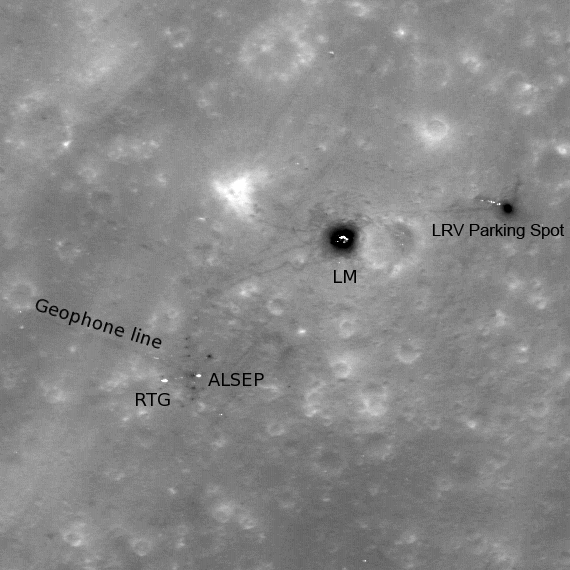
High-sun image of the Apollo 16 landing site showing the lunar module descent stage, various pieces of equipment, and disturbed lunar soil (seen as darker lines and areas) which marks where John Young and Charles Duke traversed in the spring of 1972. LROC image M109134835L, 296 m across [NASA/GSFC/Arizona State University].
Ross Beyer
LROC News System
 The lunar module Orion landed in the Descartes highlands of the Moon on 21 April 1972. The Apollo 16 mission targeted a highland region. Originally thought to be a volcanic site, the samples returned by Apollo 16 actually indicated that the highlands of the Moon primarily consist of impact-formed rocks (breccias), a substantial scientific result.
Today's featured image is an LROC NAC image of the Apollo 16 landing site, acquired when the Sun was nearly overhead, in contrast to our previous image of the site. High Sun causes white and metallic artifacts left on the surface by Young and Duke stand out in high contrast as they reflect the noon-day sun back at LROC. The Apollo 16 astronauts churned up the lunar soil (regolith) as they moved about exploring the Moon, and this disturbed material shows up as dark lines and patches. Since the astronauts spent a fair amount of time around the Lunar Module during their three extra-vehicular activities, the bright lunar module appears to have a dark halo. The same dark halo appears around the parked rover. The labels on the image are for the Lunar Module (LM), the Lunar Roving Vehicle (LRV), the Apollo Lunar Surface Experiments Package (ALSEP), the Radioisotopic Thermoelectric Generator (RTG) that powered the ALSEP, and a line of geophones that extended W by NW from the ALSEP station.
The Constellation program identified this location as a region of interest because many important scientific questions will be answered by returning here. For example, like other Apollo landing sites, the artifacts left at the Apollo 16 site provide a record of space weathering at the site since 1972. Various planned (and accidental) long duration exposure experiments (like NASA's Long Duration Exposure Facility, experiments on Mir, etc.) have been studied, but all of these have been from facilities in low Earth orbit. Studying what decades of exposure to the lunar environment does to hardware will provide key inputs to engineers designing future systems to operate for long periods in extra-terrestrial environments (Moon, asteroids, Mars).

Apollo 16 lunar module pilot Charles Duke took this photograph out of Cmdr. John Young's window as part of a panorama of their landing site, April 21, 1972. The geological importance of South Ray crater has grown in the years since investigator's initial disappointment at not immediately seeing the evidence of volcanism that had brought them to the location. The crew detected the strongest magnetic fields of any in the Apollo program. Stone Mountain, whose lower elevations Young & Duke would explore during their second EVA, is the northwestern edge of the Descartes formation. In low orbit 27 years later, Lunar Prospector would co-relate the strongest magnetic anomaly on the Moon's near side with the bright, apparently low optical maturity of a swirl, centered on the northern rim of Descartes crater, only 65 km away [NASA/ASJ/AS16-113-18300].


The Apollo 16 site also provides access to highlands regolith and rocks; highlands rocks make up about 70% of the lunar surface, and this landing site would be a great place to gather additional samples that would help us characterize the materials that comprise the majority of the lunar surface.
Browse the full-resolution NAC image here!
For more information on LROC's observation campaign for the Constellation program regions of interest read this Lunar and Planetary Science Conference abstract, and visit the LRO Science Targeting Meeting website (look for the baseball card summary sheets for each site: part 1, part 2).
No comments:
Post a Comment