Showing posts with label Ranger. Show all posts

Tuesday, February 4, 2014

Ranger: America's first successful lunar program

RANGER Lunar Probe (replica).
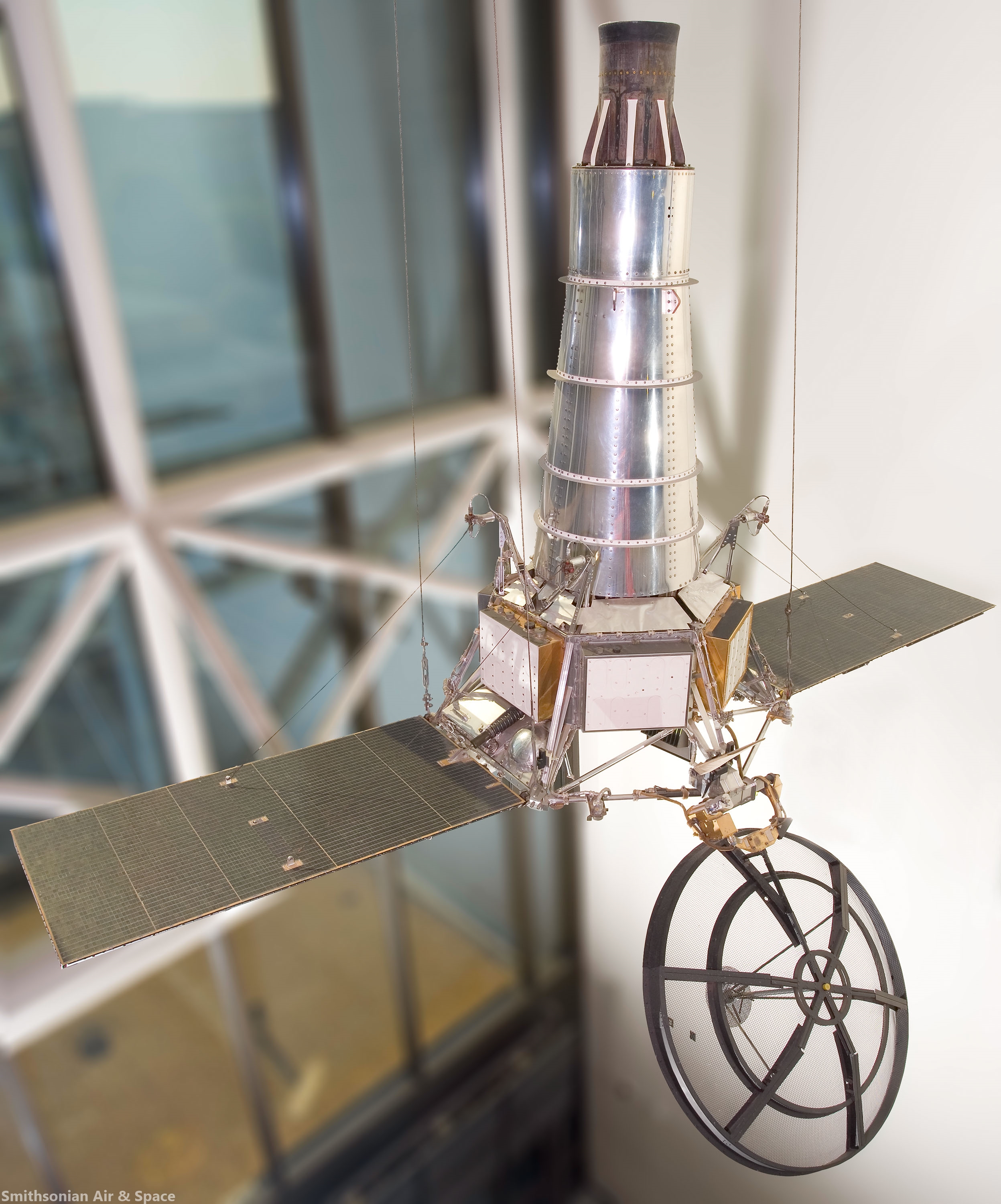
Replica of Ranger Block III (Rangers 6-9) spacecraft on display at the National Air and Space Museum. The replica spacecraft made of parts from Ranger test vehicles and is about 3 meters tall and 4.5 meters across [Smithsonian Institute].
Andrew J. LaPage
The Space Review

With the successful landing of the Chinese Chang’e-3 lunar spacecraft on December 14, 2013, and the subsequent deployment of its Yutu rover, the Western press has been filled with claims of how the Chinese are catching up with the American space program. Usually overlooked by these writers is the fact that these Chinese successes would have been almost impossible without the pioneering efforts (and many painful failures) of the American and Soviet lunar programs a half a century earlier.

NASA’s earliest Pioneer lunar probes, a program started by the military and inherited by the agency after it was founded in October 1958, were plagued by a series of launch vehicle failures (see “The Pioneer lunar orbiters: a forgotten failure”, The Space Review, December 13, 2010). Out of all of NASA’s initial attempts to launch probes towards the Moon, only the tiny six-kilogram (13-pound) Pioneer 4 built by the Jet Propulsion Laboratory (JPL) and launched on March 3, 1959, by a team at the Army Ballistic Missile Agency (ABMA) headed by Wernher von Braun (which would become the basis of NASA’s Marshall Space Flight Center) managed to escape Earth’s gravitational grasp to make a very distant flyby of the Moon.

The initial flights of NASA’s first in-house lunar program, Ranger, which was built and managed by JPL, fared little better than the Pioneers. The two flights of the Block I Ranger, which were designed to test the innovative Ranger design in extended Earth orbit, were stranded in short-lived low Earth orbits due to failures of the upper stage of the Atlas-Agena B launch vehicle (see “Ranger: Voyage to the Moon and beyond”, The Space Review, August 22, 2011). The three Block II Ranger flights, which were designed to hard-land a small probe on the lunar surface, fared little better. While most of the launch vehicle issues were resolved, fatal malfunctions of key spacecraft components resulted in complete failure of all of these missions (see “The Difficult Road to the Moon”, The Space Review, January 23, 2012).
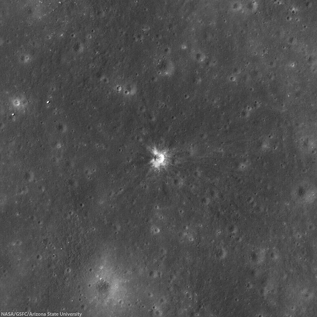
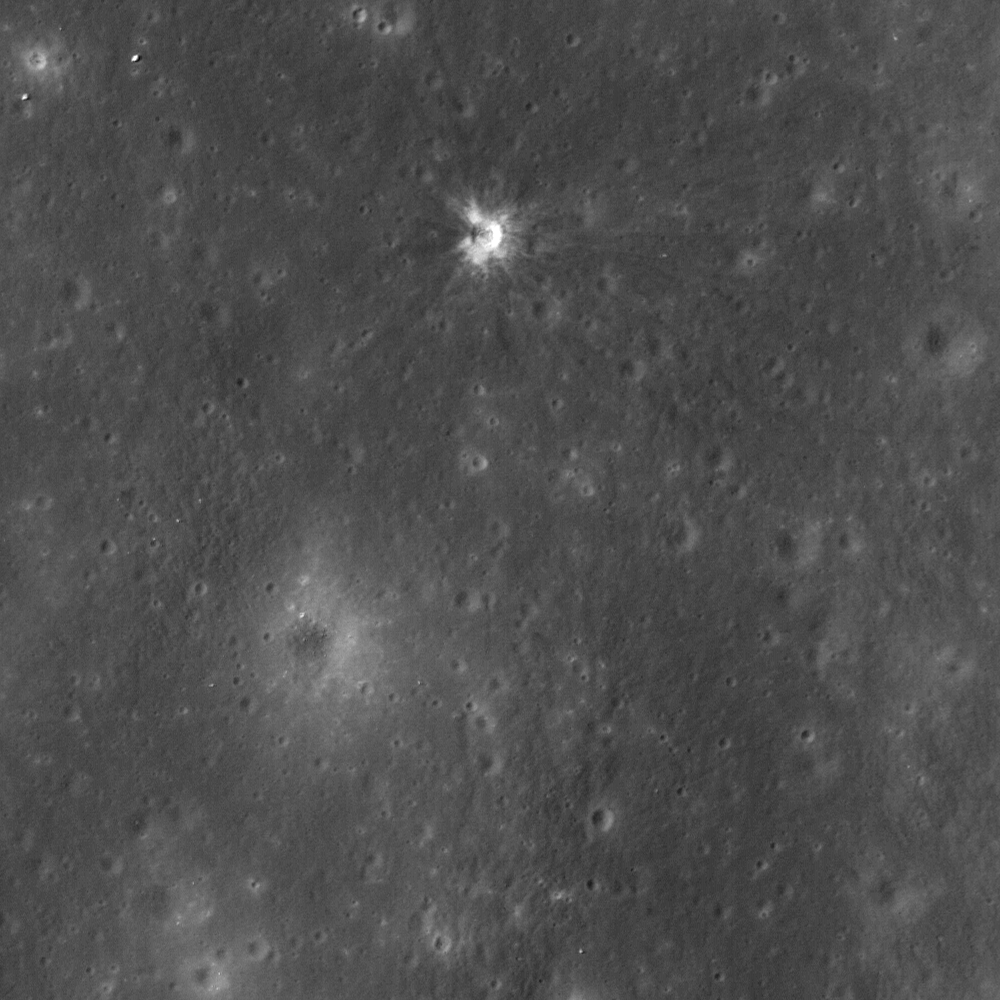
Impact site of Ranger 7, a 14 meter-wide crater near the center of Mare Cognitum (10.634°S, 20.677°W). 487 meter-wide field of view from LROC Narrow Angle Camera (NAC) observation M153014430L, LRO orbit 7693, February 22, 2011; 33.97° angle of incidence, resolution 49 centimeters per pixel from 42.69 km [NASA/GSFC/Arizona State University].
As 1962 was drawing to a close, the situation with the American Moon program looked bleak. The failure of the last Block II Ranger, Ranger 5 launched on October 16, 1962, was NASA’s sixth consecutive lunar mission failure in three years. Only 17 months after President John F. Kennedy committed the United States to landing a man on the Moon with Project Apollo, it was beginning to look as though the Americans would never make it. If NASA could not get a simple unmanned probe to the Moon in working order, how could they hope to pull off the much more complicated mission of a manned lunar landing?

Thursday, November 7, 2013

Ranger 7: Making an Impact on History

M153014430L-Ranger_7
Impact site of Ranger 7, a 14 meter-wide crater near the center of Mare Cognitum (10.634°S, 20.677°W). 487 meter-wide field of view from LROC Narrow Angle Camera (NAC) observation M153014430L, LRO orbit 7693, February 22, 2011; 33.97° angle of incidence, resolution 49 centimeters per pixel from 42.69 km [NASA/GSFC/Arizona State University].
J. Stopar
LROC News System

On 31 July 1964, Ranger 7 returned the first high resolution images of the Moon specifically collected in preparation for the Apollo lunar landings (1969-1972); the first definitive success of the Ranger program.

Rangers 1 and 2 were test missions in Earth orbit (1961), and Rangers 3 through 6 (1962-1964) were launched on an impact trajectory to the lunar surface. Rangers 3 through 6 were meant to return images of the lunar surface on approach to the Moon and up until the instant of impact, resulting in a suite of images with progressively higher and higher resolution of the lunar surface. However, only Rangers 4 and 6 met their intended target.

Despite this accomplishment, both the Rangers 4 and 6 spacecraft, due to technical problems, failed to collect or return any images leading up to their final destination. Finally, Ranger 7 (1964) was successful! It returned images of an extensively cratered terrain in Mare Cognitum, and this pioneering spacecraft paved the way to our current understanding of the composition and physical properties of the lunar surface. As a result of the images returned by Rangers 7 through 9 (1964-1965), scientists and engineers generally agreed that the lunar surface was safe for the then-upcoming Apollo missions.

RANGER replica
Replica of Ranger Block III (Rangers 6-9) spacecraft on display at the Smithsonian National Air and Space Museum. The replica spacecraft made of parts from Ranger test vehicles and is about 10 meters tall and 4.5 meters wide  [Smithsonian Air & Space].
Ranger 7 transmitted an image of its impact point in Mare Cognitum seconds before impacting at roughly 2.7 km/s. In 1972, the Apollo 16 orbital panoramic camera captured frame AS16-P-5430 that contained a view of the recently formed Ranger 7 impact crater. The figures below show a portion of this panoramic frame. The full resolution AS16-P-5430 frame can be viewed at the Apollo Image Archive. This panoramic frame allowed observation of Mare Cognitum several years after the Ranger 7 impact, revealing a new crater nearly 14 m in diameter at the exact location of the known Ranger 7 impact! This crater, along with impact craters formed by other early lunar spacecraft such as Ranger 9, are some of the earliest examples of confirmed change detections (the formation of a new feature) on the lunar surface. The details of the Ranger 7 and 9 impact craters were described by Moore in 1972 following analysis of images returned from Apollo 16.

Ranger 7 impact crater as seen in Apollo 16 panoramic camera frame AS16-P-5430 [NASA/JSC/Arizona State University].
Full width (downsampled) Apollo 16 panoramic camera frame AS16-P-5430. Yellow box shows location of Ranger 7 impact crater. North is to the right [NASA/JSC/Arizona State University].
The LROC NAC has now imaged the Ranger 7, 8, and 9 impact craters multiple times at various lighting conditions. These images can be explored in detail on our newly updated Featured Sites page.

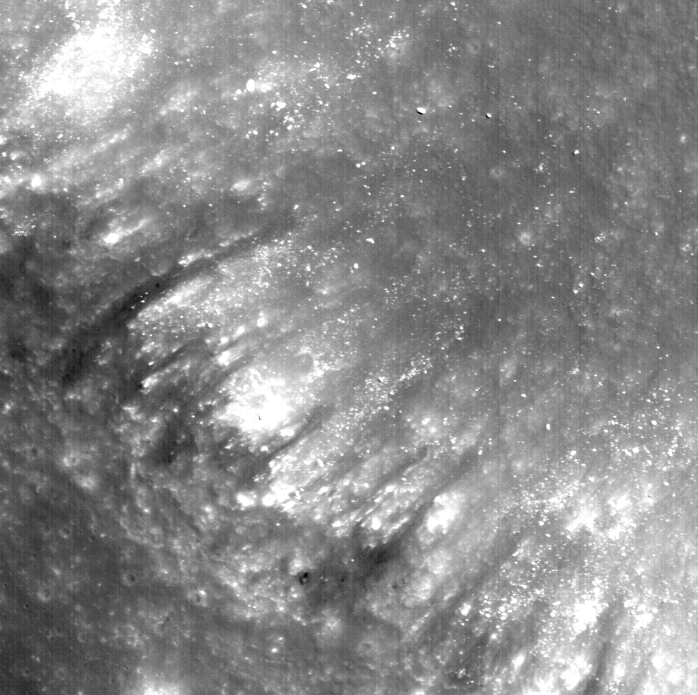
Low sun images (below) display the degree to which the mare has been extensively cratered in this part of the Moon. Hartmann (1967) originally interpreted this dense cratering to imply that the mare in this area are more than several billion years old. On the other hand, high sun images (like today's Featured Image at the top of the page) bring out the high reflectance ejecta rays that extend many crater diameters from the impact. The darker rays to the west of the crater are downrange from the known impact direction (roughly 115° east of north). The distribution of rays and their composition provide clues about direction of impact, composition of the subsurface, as well as impactor properties.

Ranger 7 impact crater
The 14 meter-wide impact crater as seen through the high-resolution LRO (LROC) Narrow Angle Camera (NAC) under high-angle (sunset) illumination, the long shadows emphasizing topography over reflectance [NASA/GSFC/Arizona State University].
The Ranger spacecraft all formed small (approximately 15 meters in diameter), roughly circular impact craters. But depending on the impact shape, mass distribution, velocity, and angle of impact, the resulting crater size and morphology vary. For example, the Apollo Saturn V launch stages (S-IVBs) that were intentionally impacted into the lunar surface between 1970 and 1972 were more massive and cylindrical in shape than the Ranger spacecraft (but impacted at a similar velocity), resulting in larger and elongate craters. A new collection of LROC NAC images of the Apollo S-IVB impactors can also be explored on our updated Featured Sites page. A full list of known coordinates of robotic spacecraft, including those that impacted the lunar surface, was also recently updated by the LROC team and can be downloaded and viewed as a map.

Explore the full LROC NAC frame of the Ranger 7 impact site, HERE.

Related Posts:
LROC Coordinates of Robotic Spacecraft 2013 Update (September 25, 2013)
Surveyor Crater, Before and After (July 9, 2013)
Graves of the GRAIL twins (March 19, 2013)
48 years of memories of Alphonsus and Ranger 9 (January 24, 2013)
Ranger 8 impact on digitized LOIRP image (July 31, 2012)
The discarded extension of the Ranger program (April 30, 2012)
"Boy, that sure looks like Luna 9!" (December 3, 2011)
Apollo 13 S-IVB Impact in Apollo seismic recordings (March 22, 2010)
The LCROSS 'Smoking Gun' (November 13, 2009)
LCROSS confirms water on the Moon (November 13, 2009)
When bombing the Moon was a good idea (October 21, 2009)
Apollo 14 S-IVB Impact Crater (October 8, 2009)

Thursday, January 24, 2013

48 Years of memories of Alphonsus and Ranger 9

Alphonsus crater, at "dead center" of experienced amateur observer and Fayetteville, North Carolina newspaperman Johnny Horne's 5 inch reflector, Saturday evening, January 19, 2013 [Fayetteville Observer].
Johnny Horne
Fayetteville Observer

Last Saturday night I was at my telescope trying some photographic techniques on the moon using a 5-inch refractor telescope. .

I was photographing the large lunar crater Alphonsus which was just coming into sunlight, its central mountain peak casting a  shadow across the crater floor.

The 67-mile wide Alphonsus was one of the first lunar craters I could identify through my small telescope as a child in the 60s…finding it with the aid of a moon map in Sky and Telescope magazine. My interest in astronomy was fueled, as was the case for so many of my generation, by the US space program…both manned and unmanned.

One evening in March 1965 I was watching the evening news, specifically a story about one of the Ranger moon probes.

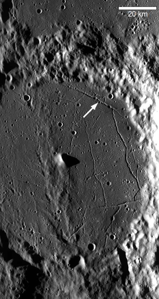
Alphonsus crater in a monochrome (689 nm) mosaic stitched together from eight sequential orbital observations of the LROC Wide Angle Camera in 2010. The March 24, 1965 impact site of Ranger 9 (captured at very high-resolution by LROC below - 12.8288°S, 2.3919°W) is marked by the arrow [NASA/GSFC/Arizona State University].
The Ranger probes, unlike later robotic probes that would soft land on or orbit the moon, were designed to impact the lunar surface…not so much a landing site as a smoking hole in the moon…

They would be taking pictures and sending them back to Earth right up until  impact.

That’s if they even made it to the moon.

Read the full article, HERE.

This exceptionally detailed photograph of the impact site of Ranger 9 on the floor of Alphonsus appears to include an inner disk of darker material perhaps 10 meters across. LROC Narrow Angle Camera (NAC) observation M170579736R, LRO orbit 10272, September 13, 2011; angle of illumination incidence 16.1° at 49.6 cm per pixel resolution from 44.64 km [NASA/GSFC/Arizona State University].

Tuesday, July 31, 2012

Ranger 8 impact on 'new' Lunar Orbiter photograph

Thumbnail of newly retrieved medium resolution frame 2069-M, a roughly 27 km-wide field of view northwest of the eventual landing site of Apollo 11, captured by Lunar Orbiter II, November 20, 1966. One year and 9 months earlier, almost to the hour, on February 20, 1965, the Ranger 8 spacecraft, performing as it was designed, impacted this part of Mare Tranquillitatis at the spot indicated by the blue arrow. Newly retrieved from original tapes by the Lunar Orbiter Image Restoration Project (LOIRP) and released July 30, 2012 [Lunar and Planetary Institute reference - Large at LOIRP and very large at the NASA Lunar Science Institute].
It helps to know precisely where to look. Because the Lunar Reconnaissance Orbiter Camera has previously surveyed and identified the location of the Ranger 8 impact with the Narrow Angle Camera (see below), and because such a large version of the Lunar Orbiter II medium resolution photograph was made available by LOIRP on the NLSI servers, it took little work to separate out the impact rays from the general washout of the terrain. The resolution above appears to be between 1.5 and 2 meters per pixel [NASA/JPL/LOIRP/NLSI].
The Ranger 8 impact at 1 meter per pixel resolution, picked out from the background (2.635°N, 24.784°E) of the LROC NAC/WAC global mosaic available using the LROC QuickMap. The slight increase in elevation running north-south through the impact zone (the Ranger 8 spacecraft arrived from the west by southwest - from the left side of these fields of view) is genuine. The terrain, at just over 2000 meters below the global mean elevation, is comparable to what was explored by Armstrong and Aldrin in 1969 [NASA/GSFC/Arizona State University].
The most recently released of several LROC high-resolution NAC observations including the Ranger 8 impact (at center). The wide variety of illuminations in the record-breaking survey allows for detailed examination of the impact site. LROC NAC observation M185719511L, LRO orbit 12450, March 7, 2012; angle of incidence 11.8° with a resolution of 0.92 meters, from 107.7 kilometers altitude [NASA/GSFC/Arizona State University].
Probably among the best shots of the central impact zone augered out by Ranger 8, from LROC NAC observation M170579736R, orbit 10272, September 13, 2011; angle of incidence 16.1° at 0.49 meters resolution, from 44.64 kilometers.
Earlier Posts and background on LOIRP (Moonviews.com):
Anniversary of Ranger 8 (February 20, 2009)
LOIRP recovers image of Ranger 8 impact (June 9, 2009)
Ranger 8 (April 4, 2010) 

LROC: Coordinates of Robotic Spacecraft (April 9, 2010)
The Spirit of the Lunar Orbiters lives on at LOIRP (July 12, 2012)

Monday, April 30, 2012

The discarded extension of the Ranger program

Site of the guided impact of Ranger 9, March 24, 1965 (12.82°S, 357.61°E). LROC Narrow Angle Camera (NAC) observation M170579736R, LRO orbit 10272, September 13, 2012; resolution 49.6 cm, angle of incidence 16.1° from 44.64 kilometers. There are images of the impact showing more relief but this most recently released view, under a high sun, balances detail with contrast exposing more detail of the wispy ejecta albedo [NASA/GSFC/Arizona State University].
David S. F. Portree
WIRED/Beyond Apollo

In the summer and fall of 1962, NASA Headquarters planned at least 18 missions in the Ranger series. Some would have imaged the moon’s surface to certify potential Apollo landing sites, while others would have had a more purely scientific intent. On December 13, 1963, however, the total shrank to nine, with science missions taking the brunt of the cuts. Ranger itself was partly to blame; all five Rangers flown up to that time had failed, undermining confidence in the program and building support for an early switch to Lunar Orbiter and Surveyor, Ranger’s intended successor programs.

The Jet Propulsion Laboratory (JPL) in Pasadena, California, built the Rangers on contract to NASA Headquarters. The probes left Earth atop Atlas rockets with Agena B upper stages (image at top of post). Rangers 1 and 2, Block I spacecraft designed to test spacecraft systems and return data on conditions in space up to 1.1 million kilometers from Earth, weighed a little over 300 kilograms each. Both reached low-Earth orbit, where they became stranded by Agena B failures. Ranger 1 lifted off on August 23, 1961, and burned up in the atmosphere a week later. NASA launched Ranger 2 on November 18, 1961; it burned up just two days later.

Ranger - Block III - spacecraft diagram [NASA].
Rangers 3 through 5 were Block II spacecraft designed to image the moon during approach and then rough-land a balsa wood-cushioned instrument capsule bearing a battery-powered seismometer. Rangers 3 and 4 weighed about 330 kilograms; Ranger 5 was somewhat heavier (342 kilograms). Ranger 3, launched on January 26, 1962, missed the moon by 36,800 kilometers on January 28 and entered orbit around the Sun. Ranger 4, launched April 23, 1962, lost power 10 hours after launch after its twin tapering solar arrays failed to open. It became the first Ranger to touch the moon, crashing inert on the lunar Farside (the hemisphere turned always away from Earth) on April 26. Ranger 5 also suffered a power failure shortly after launch on October 18, 1962; it passed about 725 kilometers over the moon on October 21 and entered solar orbit. After the Ranger 5 failure, NASA tasked the RCA Astro Division with reworking the spacecraft’s electronics.

Block III Rangers, the next in the series, were meant to radio to Earth images of the lunar surface as they plummeted toward destructive impact. All weighed about 365 kilograms. Ranger 6, the first of the Block III Rangers, left Earth on January 30, 1964. It transmitted signals until it struck the moon’s Mare Tranquillitatis – the Sea of Tranquility – within a few kilometers of its target on February 2, 1964, but its six cameras never switched on. The failure led to an independent review board, new program management, a Congressional investigation, and calls for the program’s cancellation.

Read the full article HERE.

Tuesday, March 20, 2012

Whale of a hollow

"Another Ina," a 'hollow on the Moon resembling a cave-dweller's representation of a whale, located on the western floor of Mare Tranquillitatis (8.89147°N, 21.48729°E) near the February 1964 impact of Ranger 6. LROC Narrow Angle Camera (NAC) observation M177494593R, orbit 11293, December 2, 2011; incidence angle 62.5° and at a resolution of 0.46 meters per pixel from 38 kilometers [NASA/GSFC/Arizona State University].
Joel Raupe
Lunar Pioneer

Hollows, as distinct from pit craters, have been discovered during the course of the Messenger survey of Mercury. As such, these new discoveries heightened awareness of similar features on the Moon, some of these well-known and others also newly discovered by LRO science teams.

Two hollows, or hollow clusters, for example, have been confirmed in LROC high-resolution images not far from the Moon's most famous example, "Ina," the "D Caldera" well-known to telescope observers looking for the challenging feature from Earth.

All three of these features are presumed to result from outgassing, though details of the dynamic remain elusive. Ina is the most studied, and a small cluster of hollows to its north, situated on an extrusion dome on the edge of the Serenitatis basin is the next most well known. The Ina formation had been thought to be unique, but another smaller version has turned up in three LROC Narrow Angle Camera frames showing the area in Mare Tranquillitatis where Ranger 6 made its impact in 1964.

The whale in the Sea of Tranquility (yellow oval) doesn't stand out like Ina, but even in this simulated oblique view of the LROC WAC 100 meter Global monochrome mosaic, overlaid on am elevation model assembled from LOLA laser altimetry, displayed in the NASA ILIADS application reveals how easy it is to find, if you know where to look [NASA/LMMP/GSFC/Arizona State University].

"Ina," (18.65°N, 5.3°E) an extremely young and unusual 3 by 2 km depression that may represent a gas eruption site on the Moon. LROC Narrow Angle Camera (NAC) observation M119815703, LRO orbit 2791, February 3, 2010 [NASA/GSFC/Arizona State University]
Three examples, each in very different areas of the Moon, seem to represent a range of possibilities. Ina appears very young, and it rests on a wide and flat zone at a relatively high elevation above the Serenitatis basin to its north, in the midst of hills etched deep by the primeval blast that formed Mare Imbrium. There seems to be little sign of an explosive debris field though a rivulet of melt may have run from Ina downslope to the east.

Ina, , north of Mare Vaporum, before local sunset in a roughly 46 kilometer-wide LROC Wide Angle Camera (WAC) color (689 nm) mosaic stitched from sequential observation opportunities; January 6, 2010. The feature is situated in on a high, wide and flat mesa still carrying the scars of the Imbrium impact, eons before Ina took shape. Down slope from the feature, to the east by southeast, younger surface material may be a hint of pyroclastic flow [NASA/GSFC/Arizona State University].
In contrast, a smaller version of Ina, shaped more irregularly and resembling a whale, photographed by the LROC Narrow Angle Camera (NAC) at least three times, is located in western Mare Tranquillitatis. The "Whale," about twelve kilometers south of the Ranger 6 impact (and easier to locate). Though situated on a vast mare plain and at a lower elevation the "Whale" has the tapered edges and "beads" characteristic of Ina.

The "whale" formation under a high local sun, LROC NAC
M139768545R, orbit 5731, September 22, 2010, incidence angle
13.6°, res. 0.5 meters from 44.3 km
[NASA/GSFC/Arizona State
University].
Spectral analysis of Ina, along with crater counts and analysis of space weathering has led to speculation that the feature may be less than 10 million years old, and may enen be reforming periodically. The explosive nature of most lunar morphology does not lend itself well to imagining anything forming on the Moon from something like a slow leak in a tire, but this may be just what has occurred. Despite the apparent youth of its relief Ina (and perhaps the "Whale" in Tranquility, also) don't show much sign of "optical maturity" beyond their borders, a contrasting bright and reflective debris fields we associate with craters. Ina's interior surface does show immaturity, much less of the fusing with nanophase iron from eons of bombardment by highly kinetic atomic nuclei typical of the Moon's exposed surface most everywhere else.

The inevitable reddening, the darkening, of the outer 3 cm. of the lunar surface, from relentless bombardment of solar and extra-solar radiation (particularly cosmic rays) should cause brilliant 109 million year-old Tycho, for example, to fade into the background in just shy of a billion years. But if outgassing formed, or continues to form, Ina or the "whale," both of which show compelling signs of sprightly youth in their exposed interior, where is a fallout field of ejected material beyond?

Though these features may be the result of sporadic or even continuous "slow leaks," this outgassing probably occurred at some pressure. It wouldn't take much for nearly all of this evacuated material to reach escape velocity. And yet, though it's more obvious to the human eye just beyond the lip of the "whale," there actually is a fine "spray" of accumulated, more reflective (less optically mature) material in their immediate vicinity. Just not the macro-jumble of shocked rocks and blocks of every size we are used to seeing around impact craters.

Close up of the lunar hollows that gained the most immediate interest after the discovery of similar features on Mercury, perhaps because they most closely resembled those first located there, though these vents near the apex of a shallow dome on the southwestern edge of Mare Serenitatis (24.48°N, 7.99°E) are considerable smaller.  LROC NAC M104469044R, orbit 555, August 9, 2009; incidence angle 57.65° resolution 1.45 meters per pixel from 145.5 kilometers [NASA/GSFC/Arizona State University].
A third hollow in the lunar catalog is, again, different from Ina or "the whale." The closest view we presently have of the cluster of vent associated with an extrusion dome on the southwestern edge of Mare Serenitatis may not allow us the kind of spectral analysis of their interiors now available for Ina. Disappointingly, the only high-resolution LROC NAC observation in the Planetary Data System (PDS) was captured very early in the LRO's Commissioning Phase, from 145 kilometers overhead.

How old is this extrusion dome, just inside Mare Serenitatis (right)? The southwestern part of the larger basin exhibits a lot of interesting features. The well-known basins of the nearside tend to be lower in elevation than their circumferences. For some reason, however, moving from the interior toward the southwestern edge, elevations slope in the opposite direction. What does this cluster of hollows have in common with the "open" hollows, Ina and "the whale, if anything? [NASA/JAXA/SELENE/LMMP].
It's tempting, anyway, to "see" a fine haze of less optically mature material in wisps outside these hollows, but such a leap would definitely be immature.

The "trough" on the immediate edge of southwestern Mare Serenitatis. The hollows on the apex of an extrusion dome (yellow arrow) are invisible at this scale, though the area boasts a wide anatomical variety of features testifying to the activity that happened here, probably beginning with the Imbrium impact event (over the Apennine front, upper left). A very close examination of this area's surface is needed to see if those hollows, and perhaps other features like Aratus CA, are of a more recent origin. LROC WAC monochrome (604nm) mosaic [NASA/GSFC/Arizona State University].
Related Posts:
Spectral Properties of Ina
(February 7, 2011)
It's a gas, man - (October 8, 2011)
The closest of lunar close-ups, now available (December 16, 2011)
Some LROC Highlights, M. Robinson and the LROC Team (.pdf)
LEAG Conference, December 3, 2009

Sunday, April 4, 2010

Ranger 9

Another 'Hole in One?' Candidate impact site of Ranger 9, March 24, 1965. LROC NAC M109250398RE [NASA/GSFC/Arizona State University.]

Joel Raupe
Lunar Pioneer

As follow up on the LROC Featured Image of the Constellation program Region of Interest in northeast Alphonsus on April 2, we decided to add still more about the nearby impact of Ranger 9, March 24, 1965.

It's all but certain the LROC team deliberately aimed the Narrow Angle Camera at the forty-five year-old impact as part of it's mission goals of detailing the fifty Constellation sites and locating artifacts of the first era of lunar exploration.

Using the LROC image search browser and judging by the designation of one high-sun image of the area as a "target of opportunity" (and a deliberate roll maneuver of the LRO by 2 degrees for the session on October 3, 2009, we decided to it was worth the search through the upper middle of M109250398RE. And we think it paid off.

Judging by the relative size of Ranger when compared to later Saturn V SIVB stages, for example, already highlighted in earlier LROC releases, we were not absolutely certain what this much smaller impact would look like, though we had those clues. And we had an idea that we would probably recognize Ranger 9's footprint when we saw it.

A look at M109250398RE shows a lot of bright signatures but nothing quite so fresh as the tight scene above. If this is Ranger 9's last stop, it's a wee bit more spectacular than we had hoped. Then again, our "back of the envelope" math indicated Ranger 9 hit the Moon at a relative velocity of 2600 meters per second, based simply on it's having closed the last 700 kilometers of it's journey in 270 seconds.

A quick study of the candidate site above shows, at the very least, a very fresh impact, perhaps a direct hit within a larger and much older 8 meter crater of a type very common to the area within Alphonsus. The object excavated a lot of material in gossamer spirals hundreds of meters over the older crater rim, and it may also have punched through to some much darker material below the surface.

Some of the best digging needed to find the history of the Moon and our star system (near where the Earth has also been during this long stretch of time) has already been accomplished by impacts, and in a few far rarer cases impacts set into motion by humans. Astronauts might have broken more than a few drill bits getting down to this level.

(Adding a more personal note, Ranger 9 (as I hinted earlier) was closely followed during its long plunge to the Moon's blaster surface. It was all very inspiring to at least one young American boy who saw the whole thing on his eighth birthday.)


From 700 kilometers down to less than 7, in 270 seconds, Ranger 9, the last of NASA's hard-impact trailblazers confirmed, once again, what it's immediate predecessors had been showing. The Moon looked much the same at very different altitudes, indicating the surface had experienced crater saturation. The images, concentrated on it's eventual target, indicated by the yellow spot, are progressively closer to the Moon, moving from left to right across the top, then bottom rows. (Click HERE for Mastin's full size version of the above montage.) [NASA/GSFC/NSSDC.]

Saturday, April 3, 2010

LROC: Alphonsus Constellation ROI


LROC Narrow Angle Camera closeup of a fracture in the northeast floor of Alphonsus crater. Dark pyroclastic materials are intermixed with lighter rocks and boulders from the fracture walls and appear to have moved in streamers toward the fracture floor at upper right. A NASA Constellation Region of Interest exploration site is centered to the southeast of this view. (Image width is 538 m, LROC NAC M111606491L) [NASA/GSFC/Arizona State University].

Lisa Gaddis
LROC News System

Many fractures on the Moon are seen in the floors of ancient, flat-floored highlands craters. Such fracture networks often encircle all or part of the crater floor, and in some areas they show accumulated deposits of dark volcanic material. This NAC image above (538 meters across) shows a portion of one such fracture, located in the northeastern floor of Alphonsus crater.

The fracture has been mantled by a dark, fine-grained pyroclastic deposit that appears to have moved down the wall of the fracture (at left) toward the floor (out of view to the upper right). The wall of the fracture is composed of light-colored rocks that are typical of the lunar highlands (mostly composed of anorthosite). Rocks and boulders of this bright material have also moved down the fracture wall; the largest one (near the top, center of the image) is about 8 meters across in its longest dimension. In some areas near the top of the fracture wall, dark boulders and mantling materials are seen. It is likely that this dark volcanic material came from a nearby volcanic vent located along this fracture network.

LROC Wide Angle Camera image M117507741, centered on Alphonsus crater. Approximate position of today's Featured Image is highlighted with arrow [NASA/GSFC/Arizona State University].

Pyroclastic deposits such as those observed in Alphonsus crater are formed by violently explosive eruptions of basaltic magma and may have formed in conjunction with massive outpourings of surface lava flows to the west in nearby Mare Nubium. According to Harry Hiesinger and others (2003), the mare deposits in Mare Nubium are ancient, about 3.2 to 3.5 billion years old. If Alphonsus pyroclastic deposits and Mare Nubium were indeed related, then it is likely that the Alphonsus pyroclastic deposits are about the same age. The Alphonsus pyroclastic deposits are sometimes associated with low cones that have symmetric dark 'halos'; these cones resemble cinder cones or small volcanoes on Earth.

Sunset Crater National Monument in Flagstaff, Arizona, an example of a cinder cone on Earth, is about 600 meters wide and 340 high [USGS/NPS].

In part because of these fascinating volcanoes in the floor of Alphonsus, this area was considered as a possible landing site for the Apollo 16 and Apollo 17 missions. The Ranger 9 spacecraft impacted in Alphonsus to the northeast of the central peak. Scientific interest in this crater remains high, and so Alphonsus is a high-priority target for the future human and robotic expeditions to the Moon.

Explore the Alphonsus crater Constellation region of interest for yourself.


Northeast rim of Alphonsus crater from 700 km. Ranger 9 camera B image of the northeast rim of Alphonsus crater at left, and southern rim of Ptolemaeus crater at the top. Though this image quality is matched by amateur equipment today, the subsequent images returned as Ranger 9 rushed toward impact were trailblazing, and enlightening. All three major television networks interrupted highly lucrative Saturday morning television to cover Ranger's demise. Millions watched anxiously, only forty five years ago, as this 1150 line Vidicon television still rendered "live" on their televisions at home. The scene was shot from 703.1 kilometers away from a hard impact only 4.5 minutes later. The field is approximately 120 km across and north is at top. (Ranger 9, B035) [NASA/JPL/NSSDC/GSFC.]

Wednesday, October 21, 2009

Once upon a time, bombing the Moon was a good idea!

Looking toward the south in 2007, Japan's Kaguya HDTV camera captured the target for the NASA JPL 1965 impact of Ranger 9. Even after high reduction of 70 kilometer-wide Ptolemaeus and its familiar contextual near side landscape in this 400 pixel column this still image is glorious [JAXA/NHK/SELENE].

("It seemed the whole world was watching these slow-scan images render on our black and white televisions. Of course, it's possible I remember it so well because the impact happened on my eighth birthday, though more likely it was my father being awestruck, that we were still watching the last very close-up pictures of the interior of Alphonsus after the impact had happened." - Joel Raupe)


Keith Cowing
OnOrbit-Alpha

"Last week LCROSS slammed into the Moon. Subsequent analyses showed that a large plume of debris was thrown up and that NASA captured a significant amount of data. Yet the public saw something very different: a mission that was designed to "bomb the Moon" and produce a pretty explosion - live for all to see. Well, no one watching could see anything close to what NASA had predicted. Clearly, NASA failed to explain the value of LCROSS to the public and over-hyped the anticipated visuals. That said, there was once a time when people understood what NASA did. Maybe the NASA of today should stop to look back at how it was once relevant. Oh yes: you may have heard of something hot and sexy called "participatory exploration" as it relates to new ways for NASA to engage the public. Well, guess what: NASA totally understood the concept back in 1967.

Read on, HERE.

Tuesday, June 9, 2009

LOIRP recovers image of Ranger 8 impact

Ranger 8 Impact Trajectory Overlay on LOII-070-H

Good news from Moonviews, this morning. Repeated digital passes over forty-year-old data now offers LCROSS scientists some ground truth, courtesy of the Lunar Orbiter Image Recovery Project (LOIRP). What this project has been able to do, looking at what was once analog photographic data, in more than just one way, has really be something to watch. Detail never imagined by Orbiter's original project continues to be teased out, offering hopefully a hint of what's ahead from LRO.

"The Lunar Orbiter II-070-H image (Frame 70, High resolution) has a unique feature that is relevant to the LCROSS mission. This image shows the impact site of the Ranger 8 mission. This location was identified decades ago and is discussed in the NASA SP-168 online address. This location was also photographed during the Apollo 16 mission (NASA SP-315 page 29-46) but at a lower resolution of 3-5 meters. The image was taken from an altitude of 45.81 km. The resolution is about 0.4 meters per pixel. The crater from the Ranger impact is not well defined in the existing film database, especially as it appears at the boundary between two framelets."
Scan the latest from LOIRP (Moonviews) HERE.

Friday, February 20, 2009

Anniversary of Ranger 8


Candidate for the most heavily traveled location on the Moon so far, the south-southwest corner of the Sea of Tranquillity as seen by the HDTV camera on-board the lunar orbiter KAGUYA in 2008. Ranger 8 arrived first, impacting north of the crater subsequently named after Neil Armstrong, followed by Surveyor 5 in September 1967 and finally by Armstrong and Apollo 11 lunar module pilot Edwin "Buzz" Aldrin forty years ago this July.

"Lunar Mark" Tillotson, continuing his daily Today in Astronomy celebration of the IYA2009, today highlights February 20 as the 44th anniversary of the arrival of Ranger 8, impacting the southwest Mare Tranquillitatis 73 kilometers northeast of the eventual landing site of Apollo 11, four years later.
Mark explains it all HERE.