Showing posts with label impact. Show all posts

Thursday, November 7, 2013

Ranger 7: Making an Impact on History

M153014430L-Ranger_7
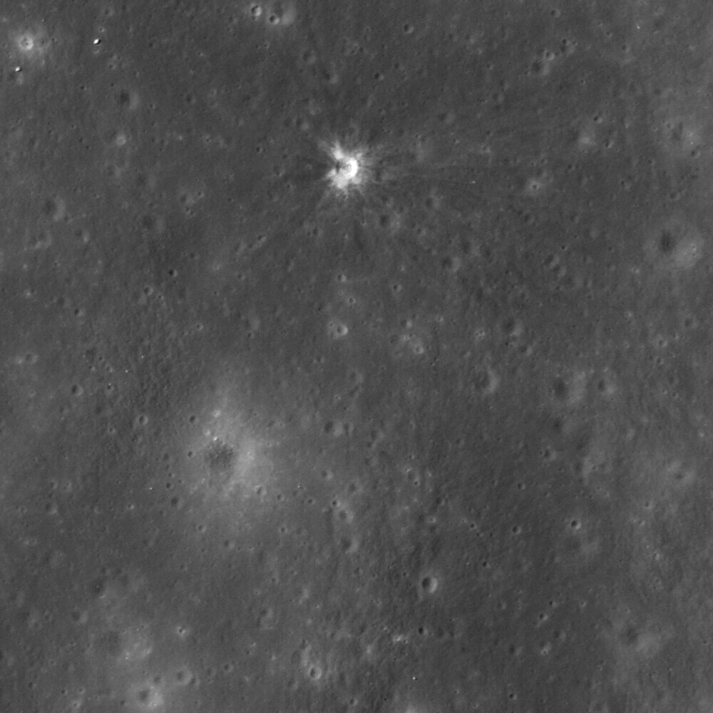
Impact site of Ranger 7, a 14 meter-wide crater near the center of Mare Cognitum (10.634°S, 20.677°W). 487 meter-wide field of view from LROC Narrow Angle Camera (NAC) observation M153014430L, LRO orbit 7693, February 22, 2011; 33.97° angle of incidence, resolution 49 centimeters per pixel from 42.69 km [NASA/GSFC/Arizona State University].
J. Stopar
LROC News System

On 31 July 1964, Ranger 7 returned the first high resolution images of the Moon specifically collected in preparation for the Apollo lunar landings (1969-1972); the first definitive success of the Ranger program.

Rangers 1 and 2 were test missions in Earth orbit (1961), and Rangers 3 through 6 (1962-1964) were launched on an impact trajectory to the lunar surface. Rangers 3 through 6 were meant to return images of the lunar surface on approach to the Moon and up until the instant of impact, resulting in a suite of images with progressively higher and higher resolution of the lunar surface. However, only Rangers 4 and 6 met their intended target.

Despite this accomplishment, both the Rangers 4 and 6 spacecraft, due to technical problems, failed to collect or return any images leading up to their final destination. Finally, Ranger 7 (1964) was successful! It returned images of an extensively cratered terrain in Mare Cognitum, and this pioneering spacecraft paved the way to our current understanding of the composition and physical properties of the lunar surface. As a result of the images returned by Rangers 7 through 9 (1964-1965), scientists and engineers generally agreed that the lunar surface was safe for the then-upcoming Apollo missions.
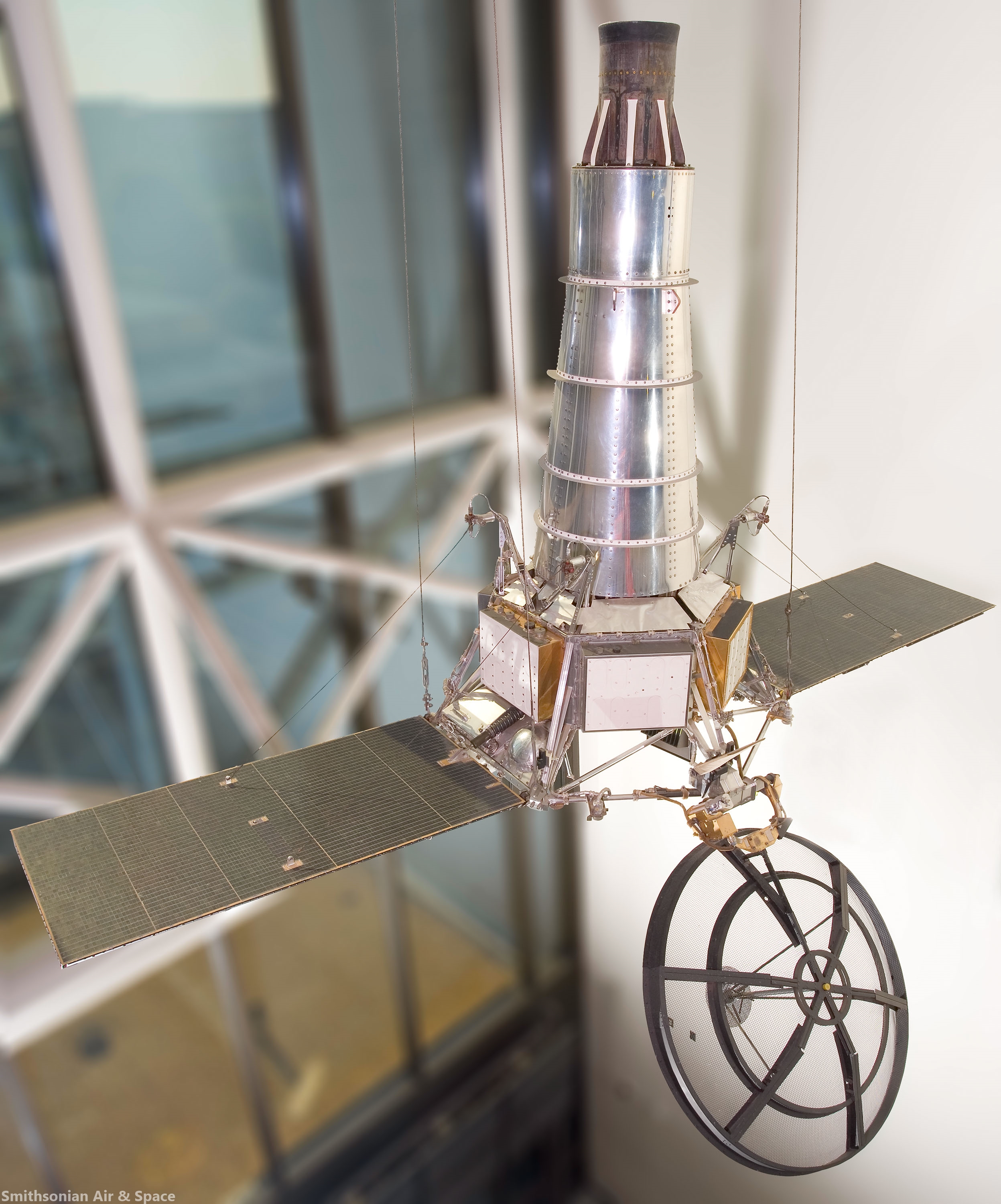
RANGER replica
Replica of Ranger Block III (Rangers 6-9) spacecraft on display at the Smithsonian National Air and Space Museum. The replica spacecraft made of parts from Ranger test vehicles and is about 10 meters tall and 4.5 meters wide  [Smithsonian Air & Space].
Ranger 7 transmitted an image of its impact point in Mare Cognitum seconds before impacting at roughly 2.7 km/s. In 1972, the Apollo 16 orbital panoramic camera captured frame AS16-P-5430 that contained a view of the recently formed Ranger 7 impact crater. The figures below show a portion of this panoramic frame. The full resolution AS16-P-5430 frame can be viewed at the Apollo Image Archive. This panoramic frame allowed observation of Mare Cognitum several years after the Ranger 7 impact, revealing a new crater nearly 14 m in diameter at the exact location of the known Ranger 7 impact! This crater, along with impact craters formed by other early lunar spacecraft such as Ranger 9, are some of the earliest examples of confirmed change detections (the formation of a new feature) on the lunar surface. The details of the Ranger 7 and 9 impact craters were described by Moore in 1972 following analysis of images returned from Apollo 16.

Ranger 7 impact crater as seen in Apollo 16 panoramic camera frame AS16-P-5430 [NASA/JSC/Arizona State University].
Full width (downsampled) Apollo 16 panoramic camera frame AS16-P-5430. Yellow box shows location of Ranger 7 impact crater. North is to the right [NASA/JSC/Arizona State University].
The LROC NAC has now imaged the Ranger 7, 8, and 9 impact craters multiple times at various lighting conditions. These images can be explored in detail on our newly updated Featured Sites page.

Low sun images (below) display the degree to which the mare has been extensively cratered in this part of the Moon. Hartmann (1967) originally interpreted this dense cratering to imply that the mare in this area are more than several billion years old. On the other hand, high sun images (like today's Featured Image at the top of the page) bring out the high reflectance ejecta rays that extend many crater diameters from the impact. The darker rays to the west of the crater are downrange from the known impact direction (roughly 115° east of north). The distribution of rays and their composition provide clues about direction of impact, composition of the subsurface, as well as impactor properties.

Ranger 7 impact crater
The 14 meter-wide impact crater as seen through the high-resolution LRO (LROC) Narrow Angle Camera (NAC) under high-angle (sunset) illumination, the long shadows emphasizing topography over reflectance [NASA/GSFC/Arizona State University].
The Ranger spacecraft all formed small (approximately 15 meters in diameter), roughly circular impact craters. But depending on the impact shape, mass distribution, velocity, and angle of impact, the resulting crater size and morphology vary. For example, the Apollo Saturn V launch stages (S-IVBs) that were intentionally impacted into the lunar surface between 1970 and 1972 were more massive and cylindrical in shape than the Ranger spacecraft (but impacted at a similar velocity), resulting in larger and elongate craters. A new collection of LROC NAC images of the Apollo S-IVB impactors can also be explored on our updated Featured Sites page. A full list of known coordinates of robotic spacecraft, including those that impacted the lunar surface, was also recently updated by the LROC team and can be downloaded and viewed as a map.

Explore the full LROC NAC frame of the Ranger 7 impact site, HERE.

Related Posts:
LROC Coordinates of Robotic Spacecraft 2013 Update (September 25, 2013)
Surveyor Crater, Before and After (July 9, 2013)
Graves of the GRAIL twins (March 19, 2013)
48 years of memories of Alphonsus and Ranger 9 (January 24, 2013)
Ranger 8 impact on digitized LOIRP image (July 31, 2012)
The discarded extension of the Ranger program (April 30, 2012)
"Boy, that sure looks like Luna 9!" (December 3, 2011)
Apollo 13 S-IVB Impact in Apollo seismic recordings (March 22, 2010)
The LCROSS 'Smoking Gun' (November 13, 2009)
LCROSS confirms water on the Moon (November 13, 2009)
When bombing the Moon was a good idea (October 21, 2009)
Apollo 14 S-IVB Impact Crater (October 8, 2009)

Tuesday, March 19, 2013

Graves of the GRAIL twins

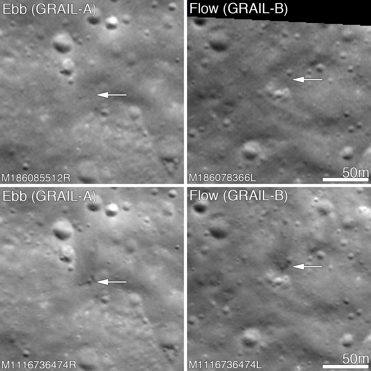
Before and after the GRAIL twins impacts on the Moon December 17, 2012. The LROC Narrow Angle Camera (NAC) directors were able to resolve the impact sites on February 28, 2013, revealing both to be about 5 meters in diameter. Upper panels show the area before the impact; lower panels after the impact. Arrows point to crater locations. LROC NAC observations M186085512R, M186078336L, M1116736474R and M1116736474L. Full size Featured Image HERE  [NASA/GSFC/Arizona State University].
Jeffrey Plescia
LROC News System

The Gravity Recovery and Interior Laboratory (GRAIL) mission ended on 17 December 2012 at 14:28 PST (-8 hrs. relative to Universal Time) when the two spacecraft GRAIL A (Ebb) and GRAIL B (Flow) impacted the Moon.

Both impact sites lie on the southern slope of an unnamed massif (mountain) that lies south of the crater Mouchez and northeast of the crater Philolaus.

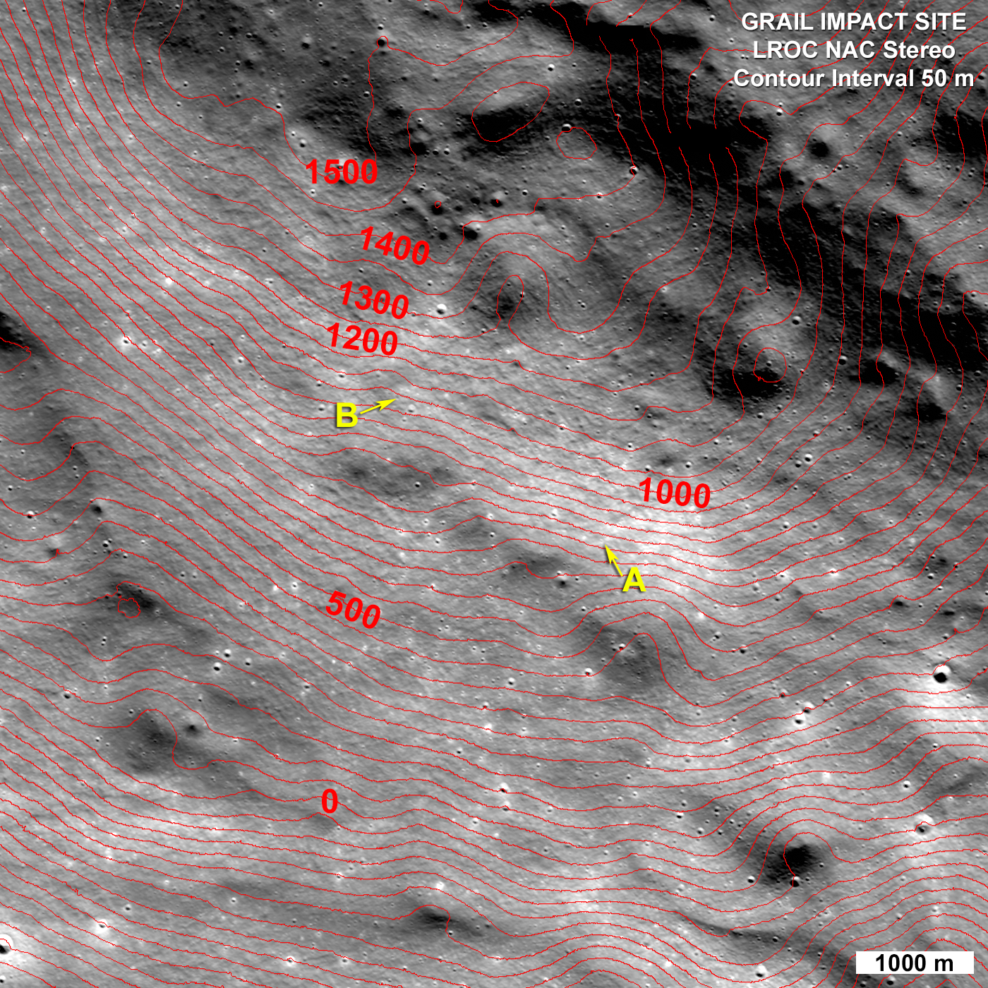
The massif stands as much as 2500 m above the surrounding plains. The impact sites are at an elevation of about 750 and 1040 meter, respectively, about 460-750 m below the summit.

Artist conception of the orbital track of the two spacecraft just before impact. Both spacecraft were tracking north as their altitude continuously decreased until they impacted the south side of the massif [NASA/JPL].
The two GRAIL spacecraft were relatively small - cubes about the size of a washing machine with a mass of about 200 kg (441 lbs) at the time of impact. When they arrived at the Moon their mass was closer to 278 kg (619 lbs), but about 78 kg (172 lbs) of that was fuel consumed during lunar operations. Both spacecraft impacted at very low angles (~2° to the horizontal) at about 1600 m/s (faster than a speeding bullet) into a fairly steep slope! LROC images reveal that both spacecraft formed craters about 5 m (15 ft) in diameter. Surprisingly, the ejecta around both craters is dark and irregularly distributed around the crater; there is little ejecta to the south - the direction from which the spacecraft were traveling.

GRAIL A site seen before and after the impact event. Crater center is located at 75.609°N, 333.407°E [NASA/GSFC/Arizona State University].
Typically ejecta from craters has a higher reflectance than the target material (think of the rays of Tycho). This normal contrast is due to the excavation of fresh (or immature) soil from beneath a more mature, weathered layer. As the lunar regolith is exposed to the vacuum of space, it suffers exposure to cosmic radiation, solar wind bombardment, and micrometeorite impacts. Slowly over time, these processes tend to darken the soil. Thus, if you dig down beneath the surface you will find higher reflectance soil.

GRAIL B site seen before and after impact event. Crater center is located at 75.651°N, 333.168°E [NASA/GSFC/Arizona State University].
So why do both GRAIL craters exhibit low reflectance rays? Perhaps we are seeing carbon from the spacecraft. The structure was made of a cyanate ester composite (carbon rich) and other materials also had carbon as primary compounds. Additionally, there was about 0.5 kg (1.1 lbs) of fuel remaining in each spacecraft. Due to the energy of impact, the carbon from these varied sources may have been released and mixed with and coated the ejecta. It takes only a very small amount of carbon to darken a material, recall in art class when you put just a few drops of black paint into a lighter color and it went all muddy. But right now we do not know for sure the cause of this interesting anomaly!

LRO Wide Angle Camera (WAC) image of the GRAIL impact area on the south side of the unnamed massif. LRO WAC M120020350 [NASA/GSFC/ASU].
On 28 February 2013 the LROC obtained a stereo pair for the impact area and from these images the LROC team produced a controlled preliminary topographic map. From the stereo model latitude, longitude and elevation were derived for each impact crater: GRAIL A 75.609°N, 333.407°E, 750 meters and for GRAIL B 75.651°N, 333.168°E, 1040 meters. The local slope of the mountain at the point of impact was 23° for GRAIL A and 19° for GRAIL B. As knowledge of the spacecraft position is refined the LROC team will update these coordinates. The two impact craters are about 2210 m apart; GRAIL B impacted about 20 seconds after GRAIL A at a site to the northwest of GRAIL A.

LROC NAC stereo derived topographic map of the GRAIL Impact area, map is 8400 meters wide, north is up [NASA/GSFC/Arizona State University].
Find the GRAIL impact craters in the full NAC image, HERE.

Related Posts:
Parting shots from Ebb MoonKAM prior to impact
Ebb and Flow Finale
Rocket Impacts Recorded by the Apollo Seismic Network
Apollo 14 S-IVB Impact Crater
Mountains of the Moon
LROC Coordinates of Robotic Spacecraft
Ejecta Sweeps the Surface