
 |
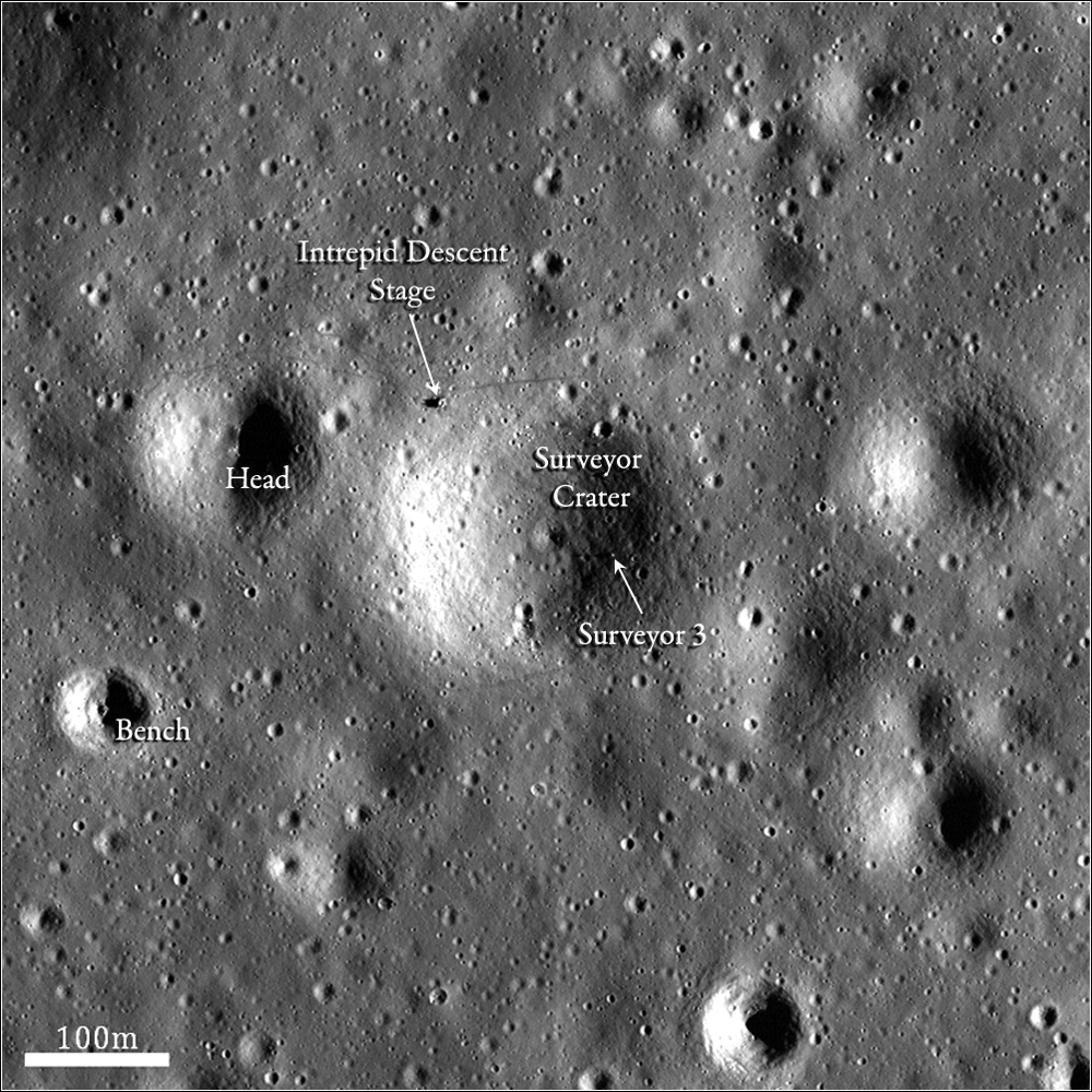
| Another look at Surveyor Crater, the Apollo 12 and Surveyor 3 landing site, under early morning illumination not much above the horizon from what Conrad & Bean encountered after the second manned landing on the Moon in November 1969. (View the labeled LROC Featured Image release HERE,, and read a description for comparisons made between a high-resolution Lunar Orbiter photograph of the same area. Field of view above is 270 meters at this, the full 47 centimeter per pixel resolution; cropped from LROC Narrow Angle Camera (NAC) mosaic M177785917RL, orbit 11336, December 6, 2011; 73.1° angle of incidence from 38.15 kilometers [NASA/GSFC/Arizona State University]. |

LROC News System
The Lunar Orbiter program, much like LRO, was designed primarily to obtain images to allow scientists and engineers to characterize the lunar surface in the context of finding safe and engaging landing sites for future missions.
A total of 5 Lunar Orbiters (LO) were sent to the Moon, and they collectively photographed most of the lunar surface at 60 to 600 meters resolution, with resolutions as high as 1 meter per pixel for some of the LO-5 photographs.
In 1967, NASA launched Lunar Orbiter 3 with the primary objective of finding safe landing sites for the Surveyor and Apollo missions. Both a Surveyor and an Apollo mission soon visited one area that the Lunar Orbiter photographed. Surveyor 3 landed on April 20, 1967 in Oceanus Procellarum at approximately 3.02°S, 23.42°W.
The spacecraft landed in a small, 200 m crater that was later named Surveyor Crater.
 |
| Recovered from the original telemetry tapes by the Lunar Orbiter Image Restoration Project (LOIRP). LO3-154 H2 was recently released, including an inset marking the Surveyor 3 and Apollo 12 expeditions [LOIRP/Moonviews.com]. |
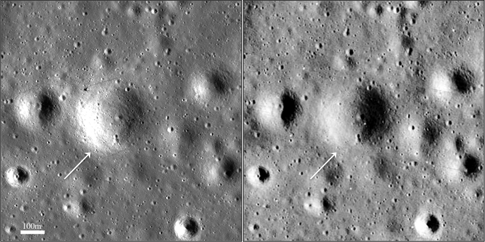 |
| LROC image M1108432631R (left, incidence angle = 68.8 degrees) and Lunar Orbiter 3 image LO3-154-H2 (right, incidence angle = 67.2 degrees) of Surveyor Crater, the eventual landing site of both Surveyor 3 and Apollo 12. Both images were taken at similar illumination geometries and the NAC image has been stretched to match the saturation seen in the LO-3 image [NASA/GSFC/USGS/LPI]. |
 |
| The LROC NAC mosaic (bottom) and an similarly arranged field of view from Lunar Orbiter image 3154-H2 (top, incidence angle = 67.2°) of Surveyor Crater, eventual landing site of Surveyor 3 and Apollo 12 soon after. |
 |
| Apollo 12 cmdr. Pete Conrad poses by the Surveyor 3 unmanned spacecraft two and a half years after the small vehicle soft landed just inside the east rim of a 200 meter crater in Oceanus Procellarum, a deliberate test and demonstration of rapid advancements in precise landing navigation necessary for future landings. Conrad holds up the sampling arm and grasps the video camera assembly, both retrieved and providing valuable study of the effects of the dusty landing plume originating from Intrepid lunar module. Alan Bean snapped this picture. [NASA/ALSJ]. |
During the Apollo 12 descent, Pete Conrad flew the spacecraft around the edge of Surveyor Crater in order to get to the safe landing spot he wanted. The crater then likely acted as a mechanism to contain the rocket exhaust, causing the entire crater to experience disturbance and appear more reflective.
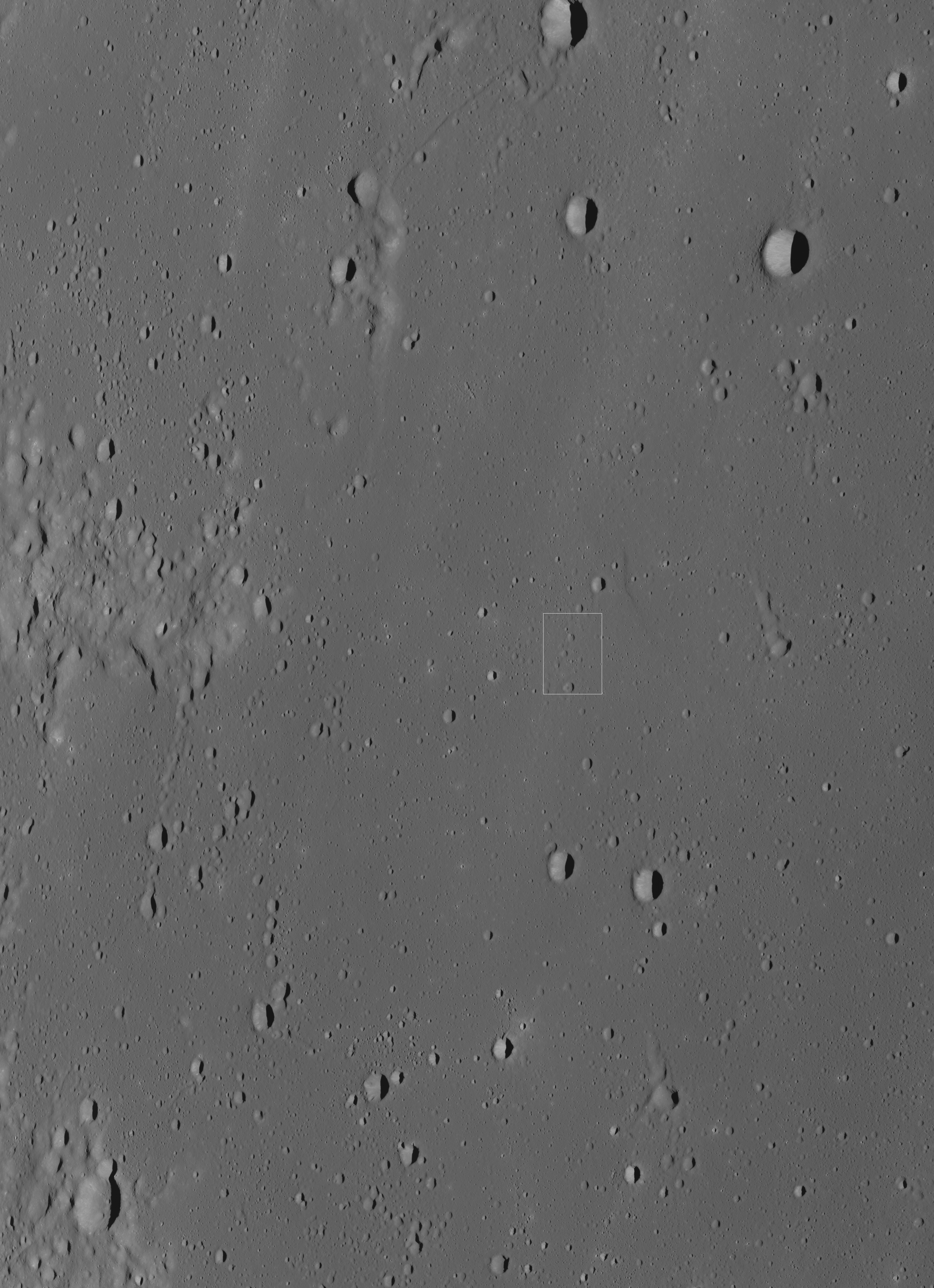 |
| A pixel, and part of another (marked by the arrow) just barely shows the Apollo 12 lunar module descent stage profile, on the "shoulder" of "The Snowman" crater group, from 106.48 kilometers above a point on the lunar surface well to the east. The original resolution above 3.5 meters per pixel, May 31, 2012. LROC NAC frame M193067752R. (The long shadow of the mast of Surveyor 3 may just be visible as a small bump on the shadow line across the interior of Surveyor crater [NASA/GSFC/Arizona State University]. |
|
| The full-width of LROC NAC frame from M193067752R, where a rectangle marks the field of view at 40% full resolution in the image immediately above, camera and spacecraft were slewed 60° off nadir, providing an unusual oblique observation. (Both this image abd the one referenced immediately above it originally used to illustrate the post "Apollo 12 at 43 Years," Nov. 20, 2012) [NASA/GSFC/Arizona State University]. |
 |
| LROC WAC context mosaic, with the location of Surveyor crater marked. Note proximity with the ejecta rays far-flung south-southwest from Copernicus, beyond the frame at upper right). Cropped from the LROC QuickMap application, set at 125 meters resolution [NASA/GSFC/Arizona State University]. |
Previous Posts:
Apollo 12 at 43 Years (November 20, 2012)
Pinpoint Landing on the Moon (Apollo 12) (March 12, 2012)
New Views of Apollo 12 (September 8, 2011)
First Low Altitude Apollo 12 NAC Image (August 11, 2011)
Triumph (and disappointment) of Apollo 12 (November 19, 2009)
Apollo 12 Second Look:Midday on the Ocean of Storms (November 4, 2009)
First Look: Apollo 12 and Surveyor 3 (September 3, 2008)
4 comments:
I can't see much of a difference in reflectivity in the crater or by the LM site. Is there a way to alter the images so they have equal contrast, so we're comparing apples to apples?
An excellent point! As a matter of fact, we intended to link to the original comparison images utilized in the LROC release, and I suppose we became distracted by our enthusiasm with a host of images in our stores and forgot.
Anyway, the tagline for that original comparison reads, "LROC image M1108432631R (left, incidence angle = 68.8 degrees) and Lunar Orbiter 3 image LO3-154-H2 (right, incidence angle = 67.2 degrees) of Surveyor Crater, the eventual landing site of both Surveyor 3 and Apollo 12. Both images were taken at similar illumination geometries and the NAC image has been stretched to match the saturation seen in the LO-3 image."
And you will find that image at the following link: http://lroc.sese.asu.edu/news/uploads/LROC_LO3_FI_thumb_arrows.png
Thanks for the reminder!
I wasn't have this kinds of detailed and in-depth knowledge about it which you mentioned over here on your post. It's unheard and totally new stuffs for me. manhattan financial advisor
Ok, that's good, the angles of incidence are very close and the sizes have been adjusted. If we could scale the light levels so their histograms would be close, any differences in reflectivity might really stand out.
Post a Comment