Showing posts with label MIT. Show all posts

Saturday, November 9, 2013

GRAIL twins put a new face on the Moon

GRAIL-crustal thickness, Olivine & KREEP
This graphic depicting the crustal thickness of the moon was generated using gravity data from NASA's GRAIL mission and topography data from NASA's Lunar Reconnaissance Orbiter [NASA/JPL-Caltech/IPGP].
Scientists using data from the lunar-orbiting twins of NASA's Gravity Recovery and Interior Laboratory (GRAIL) mission are gaining new insight into how the face of the moon received its rugged good looks. A report on the asymmetric distribution of lunar impact basins is published in this week's edition of the journal Science.

"Since time immemorial, humanity has looked up and wondered what made the man in the moon," said Maria Zuber, GRAIL principal investigator from the Massachusetts Institute of Technology in Cambridge. "We know the dark splotches are large, lava-filled, impact basins that were created by asteroid impacts about four billion years ago. GRAIL data indicate that both the near side and the far side of the moon were bombarded by similarly large impactors, but they reacted to them much differently."

Understanding lunar impact basins has been hampered by the simple fact that there is a lack of consensus on their size. Most of the largest impact basins on the near side of the moon (the moon's face) have been filled with lava flows, which hide important clues about the shape of the land that could be used for determining their dimensions. The GRAIL mission measured the internal structure of the moon in unprecedented detail for nine months in 2012. With the data, GRAIL scientists have redefined the sizes of massive impact basins on the moon.

Maps of crustal thickness generated by GRAIL revealed more large impact basins on the near-side hemisphere of the moon than on the far side. How could this be if both hemispheres were, as widely believed, on the receiving end of the same number of impacts?

Maps of the thickness of the Moon's crust from GRAIL data reveal the sizes of the Moon's great basins with unprecedented detail. The differences between the Moon's near and far sides run deep [NASA/JPL/MIT].
Scientists have long known that the temperatures of the near-side hemisphere of the moon were higher than those on the far side: the abundances of the heat producing elements uranium and thorium are higher on the near side than the far side, and as a consequence, the vast majority of volcanic eruptions occurred on the moon's near-side hemisphere.

"Impact simulations indicate that impacts into a hot, thin crust representative of the early moon's near-side hemisphere would have produced basins with as much as twice the diameter as similar impacts into cooler crust, which is indicative of early conditions on the moon's far-side hemisphere," notes lead author Katarina Miljkovic of the Institut de Physique du Globe de Paris.

The new GRAIL research is also helping redefine the concept of the late heavy bombardment, a proposed spike in the rate of crater creation by impacts about 4 billion years ago. The late heavy bombardment is based largely on the ages of large near-side impact basins that are either within, or adjacent to the dark, lava-filled basins, or lunar maria, named Oceanus Procellarum and Mare Imbrium. However, the special composition of the material on and below the surface of the near side implies that the temperatures beneath this region were not representative of the moon as a whole at the time of the late heavy bombardment. The difference in the temperature profiles would have caused scientists to overestimate the magnitude of the basin-forming impact bombardment.
Work by GRAIL scientists supports the hypothesis that the size distribution of impact basins on the far-side hemisphere of the moon is a more accurate indicator of the impact history of the inner solar system than those on the near side.

Launched as GRAIL A and GRAIL B in September 2011, the probes, renamed Ebb and Flow by schoolchildren in Montana, operated in a nearly circular orbit near the poles of the moon at an altitude of about 34 miles (55 kilometers) until their mission ended in December 2012. The distance between the twin probes changed slightly as they flew over areas of greater and lesser gravity caused by visible features, such as mountains and craters, and by masses hidden beneath the lunar surface.

NASA/JPL-CalTech news release by D.C. Agle of JPL, Dwayne Brown at NASA HQ and Sarah McDonnell of MIT.

Related Posts:
Thin crust Moon (April 24, 2013)
GRAIL - Lunar Reconnaissance Orbiter Science Update (March 24, 2013)
LAMP detects hydrogen and Hg in GRAIL impact plumes (March 19, 2013)
Graves of the GRAIL twins (March 19, 2013)
Parting shots from "Ebb" and MoonKAM prior to impact (January 10, 2013)
Impact on Mons Sally Ride, Ebb & Flow finale (December 17, 2012)
The surface of the Moon: What lies beneath? (December 11, 2012)
GRAIL twins coax out Moon, Solar System's deeper history (December 8, 2012)
JPL releases most detailed map of anomalous lunar gravity (December 5, 2012)
GRAIL twins uncover unexpectedly thin lunar crust (September 20, 2012)
GRAIL extended science mission begins (September 1, 2012)
Ebb & Flow complete primary mission (May 30, 2012)
Zuber shares lunar morphology insights at Harvard (April 20, 2012)
Flying Formation - Around the Moon at 5,800 kph (March 27, 2012)
GRAIL twins begin science mission (March 7, 2012)
The thinking behind the GRAIL twins (September 11, 2011)
GRAIL twins on their way (September 10, 2011)

Thursday, May 30, 2013

Origin of lunar MASCONS found in GRAIL data - JPL

The Moon's elusive, uneven gravity is clearly seen in this Free-Air Gravity map produced from data returned in 2012 by the twin GRAIL orbiters. Mare Imbrium, for example, at upper right presents a significant anomalous profile, concentrated near what may have been the original "transitory" crater boundary but equally reduced from the lunar average (blue) between that boundary and the outer reaches of Imbrium's present boundary [NASA/JPL/MIT].
Pasadena -- Investigators combing through the huge treasure trove of data returned to Earth by NASA's GRAIL (Gravity Recovery and Interior Laboratory) twin spacecraft Ebb and Flow in 2012 claim to have "uncovered the origin of massive invisible regions that make the moon's gravity uneven, a phenomenon affecting the stability and longevity of lunar-orbiting spacecraft," JPL announced Thursday.

"GRAIL data confirm that lunar mascons were generated when large asteroids or comets impacted the ancient moon, when its interior was much hotter than it is now," said Jay Melosh, a GRAIL co-investigator at Purdue University in West Lafayette, Ind., and lead author of the new research. "We believe the data from GRAIL show how the moon's light crust and dense mantle combined with the shock of a large impact to create the distinctive pattern of density anomalies that we recognize as mascons."

The origin of lunar mascons has been a mystery in planetary science since their discovery in 1968 by a team at NASA's Jet Propulsion Laboratory in Pasadena, Calif. Researchers generally agree mascons resulted from ancient impacts billions of years ago. It was not clear until now how much of the unseen excess mass resulted from lava filling the crater or iron-rich mantle upwelling to the crust.

On a map of the moon's gravity field, a mascon appears in a target pattern. The bulls-eye has a gravity surplus. It is surrounded by a ring with a gravity deficit. A ring with a gravity surplus surrounds the bulls-eye and the inner ring. This pattern arises as a natural consequence of crater excavation, collapse and cooling following an impact. The increase in density and gravitational pull at a mascon's bulls-eye is caused by lunar material melted from the heat of a long-ago asteroid impact.

"Knowing about mascons means we finally are beginning to understand the geologic consequences of large impacts," Melosh said. "Our planet suffered similar impacts in its distant past, and understanding mascons may teach us more about the ancient Earth, perhaps about how plate tectonics got started and what created the first ore deposits."

"Mascons also have been identified in association with impact basins on Mars and Mercury," said GRAIL principal investigator Maria Zuber of the Massachusetts Institute of Technology in Cambridge. "Understanding them on the moon tells us how the largest impacts modified early planetary crusts."

Launched as GRAIL A and GRAIL B in September 2011, the probes, renamed Ebb and Flow, operated in a nearly circular orbit near the poles of the moon at an altitude of about 34 miles (55 kilometers) until their mission ended in December 2012. The distance between the twin probes changed slightly as they flew over areas of greater and lesser gravity caused by visible features, such as mountains and craters, and by masses hidden beneath the lunar surface.

Monday, January 21, 2013

Why the Moon looms large on the horizon: Binocular disparity as an explanation for the moon illusion

Is the Moon really larger at the horizon than overhead, or is this an illusion, created in our heads? [Photograph by Robert Arn, AstroArn Photography].
Joseph Antonides, Toshiro Kubota

We present another explanation for the moon illusion, in which the moon looks larger near the horizon than near the zenith. In our model, the sky is considered a spatially contiguous and geometrically smooth surface. When an object (like the moon) breaks the contiguity of the surface, humans perceive an occlusion of the surface rather than an object appearing through a hole. Binocular vision dictates that the moon is distant, but this perception model dictates that the moon is closer than the sky. To solve the dilemma, the brain distorts the projections of the moon to increase the binocular disparity, which results in increase of the angular size of the moon. The degree of the distortion depends upon the apparent distance to the sky, which is influenced by the surrounding objects and the condition of the sky. The closer the sky appears, the stronger the illusion. At the zenith, few distance cues are present, causing difficulty with distance estimation and weakening the illusion.

Read the research paper, HERE.

News story with commentary from MIT: "Moon illusion: New theory reignites debate over why Moon appears larger near the horizon," The Physics arXiv Blog, January 17, 2013

Full Moon rises over the ruins of the Temple of Poseidon, Cape Sounion, 69 km south-southeast of Athens, southernmost tip of the Attica peninsula in Greece. Seventeen sequential images by John Doukoumopoulos, June 18, 2008 [Lunar Picture of the Day (LPOD), June 20, 2008].

Friday, December 14, 2012

Appearance of the Moon during the GRAIL impacts

GRAIL's Final Resting Spot.  These maps of Earth's moon highlight the region where the twin spacecraft of NASA's Gravity Recovery and Interior Laboratory (GRAIL) mission will impact on Dec. 17, marking the end of its successful endeavor to map the moon's gravity. The two washing-machine-sized spacecraft, named Ebb and Flow, will impact an unnamed mountain above of 75°N. [NASA/GSFC/Arizona State University].
Pasadena (JPL) -- Twin lunar-orbiting NASA spacecraft that have allowed scientists to learn more about the internal structure and composition of the moon are being prepared for their controlled descent and impact on a mountain near the moon's north pole at about 2028 UT (5:28 p.m. U.S. EST) Monday, December 17.

Ebb and Flow, the Gravity Recovery and Interior Laboratory (GRAIL) mission probes, are being sent purposely into the lunar surface because their low orbit and low fuel levels preclude further scientific operations. The duo's successful prime and extended science missions generated the highest-resolution gravity field map of any celestial body, providing a better understanding of how Earth and other rocky planets in the solar system formed and evolved.
Perspective on the Moon at the estimated time of the GRAIL impacts, projected at 2229 UT, 17 December 2012. Waxing between New and First Quarter (4.58 days 26.8% illumination), the distance between Earth and Moon will be increasing at roughly 10 km per minute from 372,628 kilometers. In eastern North America, the Moon will have transited, riding low and west from overhead Only the best equipped observers can hope to observe the actual release of kinetic energy, an extremely fast flash, near the horn of the north-northwest limb [Virtual Moon Atlas].
"It is going to be difficult to say goodbye," said GRAIL principal investigator Maria Zuber of the Massachusetts Institute of Technology in Cambridge. "Our little robotic twins have been exemplary members of the GRAIL family, and planetary science has advanced in a major way because of their contributions."

Lunar Heritage Sites and GRAIL's Final Mile. This graphic highlights locations on the moon NASA considers "lunar heritage sites" and the path NASA's Gravity Recovery and Interior Laboratory spacecraft will take on their final flight. Navigators on the GRAIL team have designed an end of mission plan that rules out the extremely remote possibility of either of the two GRAIL spacecraft impacting near any of these historic locations. The Apollo 11, 12, 14, 16 and 17 landing sites are indicated with green circles. The Surveyor sites are indicated with yellow squares. The Soviet Union's Luna and Lunakhod landing sites are indicated with red diamonds and red squares, respectively.  The ground track for the Ebb and Flow spacecraft during their final half-orbits is shown in black. The maps are color-coded by topography. Red and white indicate the high areas. Blue and violet indicate low areas [NASA/JPL-Caltech].

The mountain where the two spacecraft will make contact is located near a crater named Goldschmidt. Both spacecraft have been flying in formation around the moon since Jan. 1, 2012. They were named by elementary school students in Bozeman, Mont., who won a contest. The first probe to reach the moon, Ebb, also will be the first to go down, at 2:28:40 p.m. PST. Flow will follow Ebb about 20 seconds later.

Both spacecraft will hit the surface at 3,760 mph (1.7 kilometers per second). No imagery of the impact is expected because the region will be in shadow at the time.

Ebb and Flow will conduct one final experiment before their mission ends. They will fire their main engines until their propellant tanks are empty to determine precisely the amount of fuel remaining in their tanks. This will help NASA engineers validate fuel consumption computer models to improve predictions of fuel needs for future missions.

"Our lunar twins may be in the twilight of their operational lives, but one thing is for sure, they are going down swinging," said GRAIL project manager David Lehman of NASA's Jet Propulsion Laboratory in Pasadena, Calif. "Even during the last half of their last orbit, we are going to do an engineering experiment that could help future missions operate more efficiently."

Because the exact amount of fuel remaining aboard each spacecraft is unknown, mission navigators and engineers designed the depletion burn to allow the probes to descend gradually for several hours and skim the surface of the moon until the elevated terrain of the target mountain gets in their way.

Ebb and Flow's Final Moments. These side-by-side, 3-D comparisons depict the unnamed lunar mountain targeted by the NASA's Gravity Recovery and Interior Laboratory (GRAIL) mission for controlled impact of the Ebb and Flow spacecraft. They also include the ground tracks the spacecraft are expected to follow into the lunar terrain. These graphics were generated using data from the Lunar Orbiter Laser Altimeter instrument aboard NASA's Lunar Reconnaissance Orbiter spacecraft. On the left is the mountain with the ground track and mission termination point for the Ebb spacecraft. On the right is the mountain, ground track and mission termination point for the Flow spacecraft [NASA/JPL-Caltech/MIT/GSFC].

The burn that will change the spacecrafts' orbit and ensure the impact is scheduled to take place Friday morning, Dec. 14.

"Such a unique end-of-mission scenario requires extensive and detailed mission planning and navigation," said Lehman. "We've had our share of challenges during this mission and always come through in flying colors, but nobody I know around here has ever flown into a moon mountain before. It'll be a first for us, that's for sure."

During their prime mission, from March through May, Ebb and Flow collected data while orbiting at an average altitude of 34 miles (55 kilometers). Their altitude was lowered to 14 miles (23 kilometers) for their extended mission, which began Aug. 30 and sometimes placed them within a few miles of the moon's tallest surface features.

The published impact coordinates for the GRAIL twins has been well-surveyed by the Lunar Reconnaissance Orbiter Camera (LROC), at least nine times at high-resolution. LROC QuickMap 125 meter resolution [NASA/GSFC/Arizona State University].
JPL manages the GRAIL mission for NASA's Science Mission Directorate in Washington. The mission is part of the Discovery Program managed at NASA's Marshall Space Flight Center in Huntsville, Ala. Lockheed Martin Space Systems in Denver built the spacecraft. JPL is a division of the California Institute of Technology in Pasadena.

For more information about GRAIL, visit: http://grail.nasa.gov and http://www.nasa.gov/grail.

Tuesday, December 11, 2012

The surface of the Moon: What lies beneath?

The Moon's anisotropic composition is well represented in this Mercator projection of lunar gravity, mapped at unprecedented resolution by the twin GRAIL lunar orbiters and centered on the Moon's farside [NASA/JPL/MIT].
Paul D. Spudis
Smithsonian Air & Space

The NASA mission GRAIL (Gravity Recovery And Interior Laboratory) has been orbiting the Moon since last spring.  The mission consists of two identical small spacecraft (dubbed Ebb and Flow) that very carefully keep track of their relative position from each other.  By tracking both of these spacecraft with high precision from Earth, we can monitor any small variations (caused by variations in the Moon’s gravity field) away from their predicted orbital paths.  If the satellite is flying over an area on the Moon with less material than normal (for example, over a deep crater, a hole in the Moon’s crust), it will be less attracted to the Moon because of this mass deficiency and will therefore fly away from the Moon.  If, on the other hand, it flies over an area of excess mass, such as a thick stack of dense lava flows, the excess mass pulls the satellite slightly toward it, increasing its speed and pulling it downwards.  As Ebb and Flow orbit the Moon, they conduct a delicate “dance.”  These movements are caused by variations in the Moon’s gravity (largely a reflection of variations in the density of its crustal rocks).  When combined with the high-resolution, precision topography of the Moon (currently being gathered by the Lunar Reconnaissance Orbiter), we are able to reconstruct the structure and thickness of the lunar crust from orbit.

GRAIL has unveiled a new global gravity data set, very high in resolution and precision and greater than ten times better than our previous version of the global gravity from the Japanese mission SELENE (Kaguya).  One interesting result shows unusual structure – long, quasi-linear gravity features appear in a variety of locations associated with lunar impact basins.  Basins are very large craters that formed during asteroid collisions prior to 3.8 billion years ago.  Some of these linear features extend on great circles across the lunar globe for distances of more than 500 km. These results suggest that solidified intrusions of once-molten rock may form a dense, criss-crossing network within the upper crust.

In order to understand the significance of these gravity features, it is necessary to understand some elementary facts about planetary geology.  Planets generate heat and this heat must be dissipated.  Typically, the heat generated from both the original energy release during formation (accretion) and from the decay of radioactive elements (e.g., uranium) melts the interiors of planets, forming bodies of liquid rock called magma.  This magma is usually less dense than the rocks from which it forms and thus, rises upwards towards the surface.  Sometimes, the molten rock cannot ascend any higher from the deep locations where it comes from and freezes in place – geologists call this type of frozen rock body an intrusion, because it intrudes into pre-existing rock as a liquid and then solidifies by crystallizing.  When magma actually reaches the surface of a planet, it can erupt onto its surface as lava; this activity is called extrusive because the molten rock extrudes onto the surface and then solidifies as lava flows.

Clearly, all erupting lava must have at one time been an intrusive magma body, at least during the time it was ascending upwards toward the surface.  Although many magma bodies reach the surface and create lava flows (such as the dark, smooth maria of the lunar lowlands), sometimes this magma cannot reach the surface and freezes in place within the crust as a linear or tabular body.  Such features (called dikes) are an essential part of the underground, igneous plumbing of volcanoes on all of the terrestrial planets.  We knew that they must have formed on the Moon because we saw the evidence of vents and structures in the maria that are the surface expression of such features.

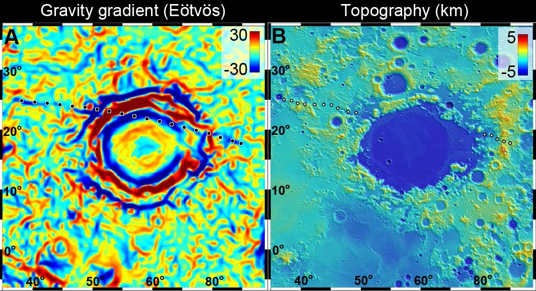
For the first time, the new GRAIL data show us direct evidence for these buried igneous dikes within the lunar crust.  One particularly prominent dike occurs near the Crisium basin, on the eastern near side of the Moon.  This dike extends over 1000 km in a quasi-radial direction northwest of the Crisium rim, disappearing beneath the mare lavas of that basin.  The fact that it is not clearly aligned with the basin structure suggests that it may predate it; we estimate that Crisium basin is older than 3.9 billion years.

Newly released GRAIL lunar gravity gradient map centered on Mare Crisium. An otherwise essentially invisible 300 km-long density of mass was detected buried under 3.9 billion year old Crisium (dotted line) [NASA/JPL/MIT].
Small scale topography of the Crisium basin, assembled from laser data points collected by the LOLA instrument aboard the Lunar Reconnaissance Orbiter [NASA/GSFC].
Mare Crisium and vicinity in a monochrome 1240 km-wide field of view from the LROC Wide Angle Camera 100 meter resolution global mosaic [NASA/GSFC/Arizona State University].
This long linear feature may have been formed when molten magma from the deep interior of the Moon oozed its way toward the surface, before “freezing” at some intermediate level.  Its presence, evident now only by a faint gravity signature (those denser areas “tugging” on the GRAIL satellites “Ebb” and “Flow”), is a tell-tale remnant of its existence deep inside the Moon’s crust.

The highly-detailed GRAIL lunar gravity gradient orthographic map, centered near 60° E meridian (and Mare Crisium, above center). The third of the hemisphere at right is on the Moon's farside. To view the spectacular new animations at their highest-available resolution by visiting the Science Visualization Studio (SVS) at NASA Goddard Space Flight Center, HERE [NASA/JPL/MIT/GSFC/SVS].
Many other linear and circular features are evident in the gravity gradient map produced by GRAIL.  Most of these seem to be associated with the large basins of the lunar highlands, the largest impact craters on the Moon. These features both excavate large amounts of crustal material during formation, and serve as topographic lows and structural traps for the accumulation of subsequent erupted lavas.  The gradient structures show a complex network of density patterns in the shallow subsurface of the Moon; this area is a morass of crushed rock, fractures, large faults and collapse features.  The entire outer portion of the lunar crust has been shattered and broken by an impact barrage of almost unimaginable violence.  The crust has since been partly annealed together by heat, re-fractured by additional impacts, intruded by large bodies of molten rock, resurfaced by the eruption of lavas from the deep interior, and finally has had its outermost surface pulverized into a fine powder by the micrometeorite bombardment.

The Moon may look like a silent, dead world but its past (which is Earth’s past) is testament to an early history of extreme violence and chaos.  The results from the GRAIL mission are helping us understand this complex story.

Originally published at his Smithsonian Air & Space blog The Once and Future Moon, Dr. Spudis is a senior staff scientist at the Lunar and Planetary Institute. The opinions expressed are those of the author and are better informed than average.

Saturday, December 8, 2012

GRAIL twins coax out the Moon's deeper history of the solar system's early, pulverizing bombardment

GRAIL primary mission global gravity map, centered on 0°N, 355°E, from animation released Dec. 5, 2012. Science Visualization Studio (SVS), GSFC [NASA/JPL/MIT].
Jennifer Chu
MIT

Beneath its heavily pockmarked surface, the moon’s interior bears remnants of the very early solar system. Unlike Earth, where plate tectonics has essentially erased any trace of the planet’s earliest composition, the moon’s interior has remained relatively undisturbed over billions of years, preserving a record in its rocks of processes that occurred in the solar system’s earliest days.

Now scientists at MIT, NASA, the Jet Propulsion Laboratory and elsewhere have found evidence that, beneath its surface, the moon’s crust is almost completely pulverized. The finding suggests that, in its first billion years, the moon — and probably other planets like Earth — may have endured much more fracturing from massive impacts than previously thought.

The startling observations come from data collected by NASA’s Gravity Recovery and Interior Laboratory (GRAIL) mission. Since March, the mission’s twin spacecraft, named Ebb and Flow, have been orbiting the moon and measuring its gravitational field.

From GRAIL’s measurements, planetary scientists have now stitched together a high-resolution map of the moon’s gravity — a force created by surface structures such as mountains and craters, as well as deeper structures below the surface. The resulting map reveals an interior gravitational field consistent with an incredibly fractured lunar crust.

“It was known that planets were battered by impacts, but nobody had envisioned that the [moon’s] crust was so beaten up,” says MIT’s Maria Zuber, who leads the GRAIL mission and is the E.A. Griswold Professor of Geophysics in the Department of Earth, Atmospheric and Planetary Sciences. “This is a really big surprise, and is going to cause a lot of people to think about what this means for planetary evolution.” 

Zuber and her colleagues detail their findings from GRAIL in three papers published this week in Science.

GRAIL’s lunar gravity map has also revealed numerous structures on the moon’s surface that were unresolved by previous gravity maps of any planet, including volcanic landforms, impact basin rings, and many simple, bowl-shaped craters. From GRAIL’s measurements, scientists have determined that the moon’s crust, ranging in thickness from 34 to 43 kilometers, is much thinner than planetary geologists had previously suspected. The crust beneath some major basins is nearly nonexistent, indicating that early impacts may have excavated the lunar mantle, providing a window into the interior.

Lifting a veil: In addition to mapping the Moon's anisotropic gravity with unprecedented granularity, the GRAIL primary mission uncovered deeper, essentially vertical dyke structures hundreds of kilometers long, the existence of which had been erased at the surface [NASA/JPL/MIT].

To generate the gravity map, GRAIL’s two probes measure the changing distance between themselves as they orbit in tight formation around the moon. As one of the probes flies over a large mass, such as a mountain or dense, underground rock, the stronger local gravity will pull that probe ahead, widening the space between the two spacecraft. Scientists can translate this changing distance into a gravitational map, representing the gravity produced by both the surface structures and the interior.

To find the gravitational field for the moon’s interior alone, Zuber’s team used topographic measurements from another of their instruments, a laser altimeter aboard the Lunar Reconnaissance Orbiter, a separate spacecraft in orbit around the moon. The scientists calculated the gravitational field expected to be produced by the moon’s topography — its surface structures alone — then subtracted that field from the field measured by GRAIL.

“It’s essentially like removing a veil to reveal the gravity due to the inside of the planet,” Zuber says. “And when we saw those maps, we were just speechless.”

The GRAIL primary science mission also succeeded in definitively mapping the thickness of the Moon's outer crust, shown in another global animation centered over the thickest zones on the lunar farside. The South Pole-Aitken basin, oldest and largest identified impact at 4.1 billion years, hosts some of the thinnest outer crust. The mission has increased the likelihood that fragments of the Moon's deeper zones will eventually be found on the surface, excavated by complex craters located on or near the basin's rim [NASA/JPL/MIT].
Compared to the surface, the map of the interior looked extraordinarily smooth. In fact, the team found that most of the moon’s local gravity is due to surface features, such as crater rims and mountains. Except for the large impact basins, the moon’s upper crust, largely lacks dense rock structures, and is instead likely made of porous, pulverized material.

The interior map did reveal long, linear structures of denser material, which Zuber and her team believe to be buried lunar dikes — formed from magma that seeped into large fractures in the crust, and then solidified into dense walls of rock. These dikes represent evidence for expansion of the moon in its earliest history. But overall, 98 percent of the lunar crust is fragmented — a clear remnant of very early, very massive impacts.

“This is interesting for the moon,” Zuber says. “But what it also means is that every other planet was being bombarded like this.” The resulting fractures, she says, affect the way a planetary body loses heat and also provide a pathway for the transport of interior fluids.

David Kring, a senior staff scientist at the Lunar and Planetary Institute in Houston, says knowing the extent of pulverization in the moon’s crust is an essential detail needed to determine the moon’s bulk composition. Such information would go a long way toward identifying the processes the formed the moon and other planets.

“The staggering quality of the data reported by Professor Zuber and her colleagues is amazing,” says Kring, who was not involved in the research. “The data are exciting because they foretell far more insights than are captured in these initial three papers.”
NASA has scheduled a news conference to discuss the planned deorbiting and impact of the GRAIL spacecraft, December 13.


In addition to GRAIL’s discoveries, Zuber says another major accomplishment has been the performance of the spacecraft themselves. To achieve the mission’s science goals, the two probes, which can travel more than 200 kilometers apart, needed to be able to measure changes in the distance between them to within a few tenths of a micron per second. But GRAIL actually outperformed its measurement requirements by about a factor of five, resolving changes in spacecraft distance to several hundredths of a micron per second — one twenty-thousandth the velocity that a snail travels. 

“On this mission, with two spacecraft, everything had to go perfectly twice,” Zuber says, adding proudly: “Imagine you’re a parent raising a twins, and your children sit down at the piano and play a duet perfectly. That’s how it feels.”

Wednesday, December 5, 2012

JPL releases most detailed map of lunar gravity

From JPL's newly released GRAIL Map of Moon's Crust, a still frame centered near 240° East, for comparison with the LROC WAC orthographic projection at the end of the previous post [NASA/JPL/MIT]
The GRAIL twin spacecraft, "Ebb" and "Flo," in close orbit around the Moon, have generated the highest resolution gravity field map of any celestial body.

The new map, created by the Gravity Recovery and Interior Laboratory (GRAIL) investigators, is allowing scientists to learn about the Moon's internal structure and composition in unprecedented detail. Data from the two "washing machine-sized" spacecraft also will provide a better understanding of how Earth and other rocky planets in the solar system formed.

The gravity field map reveals an abundance of features never before seen in detail, tectonic structures, volcanic landforms, basin rings, central peaks and numerous simple craters. Data also show the Moon's gravity field is unlike that of any known rocky planet.
These are the first scientific results from the prime phase of the mission, and they are published in three papers in the journal Science.

"What this map tells us is, more than any other celestial body we know, the Moon wears its gravity field on its sleeve," said GRAIL Principal Investigator Maria Zuber of the Massachusetts Institute of Technology. "When we see a notable change in the gravity field, we can sync up this change with surface topography features such as craters, rilles or mountains."

Zuber says the Moon's gravity field preserves the record of impact bombardment that characterized all terrestrial planetary bodies and reveals evidence for fracturing of the interior extending to the deep crust and possibly the mantle. This impact record is preserved, and is now more precisely measured, on the Moon.

The probes revealed the bulk density of the moon's highland crust is substantially lower than generally assumed.

From JPL's newly released GRAIL Gravity Map of the Moon [NASA/JPL/MIT].
This low-bulk crustal density agrees well with data obtained during the late Apollo "J" missions, that samples returned by astronauts are indicative of global processes.

"With our new crustal bulk density determination, we find the average thickness of the moon's crust is between 34 and 43 kilometers, about 10 to 20 kilometers thinner than previously thought," said Mark Wieczorek, GRAIL co-investigator at the Institut de Physique du Globe de Paris

"With this crustal thickness, the bulk composition of the moon is similar to that of Earth. This supports models where the moon is derived from Earth materials that were ejected during a giant impact event early in solar system history."

The map was created by the spacecraft transmitting radio signals to define precisely the distance between them as they orbit the Moon in formation. Orbiting over areas of greater or lesser gravity related to visible features, such as mountains and craters, and masses hidden beneath the lunar surface, the distance between the two spacecraft changed slightly.

"We used gradients of the gravity field in order to highlight smaller and narrower structures than could be seen in previous datasets," said Jeff Andrews-Hanna, a GRAIL guest scientist with the Colorado School of Mines. "This data revealed a population of long, linear gravity anomalies, with lengths of hundreds of kilometers, crisscrossing the surface. These linear gravity anomalies indicate the presence of dikes, or long, thin, vertical bodies of solidified magma in the subsurface. The dikes are among the oldest features on the moon, and understanding them will tell us about its early history."

While results from the primary science mission are just beginning to be released, the collection of gravity science by the lunar twins continues. GRAIL's extended mission science phase began August 30 and concludes December 17. As End of Mission nears, the spacecraft will operate at lower orbital altitude.

When launched in September 2011, the probes were named GRAIL A and B. They were renamed Ebb and Flow last January by elementary students in Bozeman, Montana, following a nationwide contest. Ebb and Flow were placed in near-polar, near-circular orbit at an altitude of approximately 55 kilometers, December 31, 2011 and January 1, 2012, respectively.

NASA's Jet Propulsion Laboratory in Pasadena, Calif., manages the mission for NASA's Science Mission Directorate in Washington. GRAIL is part of the Discovery Program managed at NASA's Marshall Space Flight Center in Huntsville, Ala. Lockheed Martin Space Systems of Denver built the spacecraft.

To view the lunar gravity map, visit http://bit.ly/grailtour . For more information about the mission, visit HERE .

Thursday, September 20, 2012

GRAIL twins uncover unexpectedly thin lunar crust

GRAIL gravity measurement schematic
Eugenie Samuel Reich
Nature

A sneak peek at the first results from a NASA mission to measure the Moon’s gravitational field hints at a lunar crust that is only half as thick as once thought.

There were a few gasps among scientists in the audience at a 13 September seminar at the Harvard-Smithsonian Center for Astrophysics in Cambridge, Massachusetts, as they took in the data revealed by Maria Zuber, principal investigator for NASA’s Gravity Recovery and Interior Laboratory (GRAIL) mission. Zuber, a planetary scientist at the Massachusetts Institute of Technology in Cambridge, showed a crisp, high-resolution gravitational map made with data collected by GRAIL’s twin spacecraft between March and June of this year.

“We are three to four times better in resolution compared to Kaguya and Lunar Prospector,” said Zuber, referring to two previous missions that mapped the Moon's gravitational field. GRAIL’s results have not yet been published or released publicly by NASA, and Zuber was not at liberty to give an interview.

Yet her talk, and the thrilled reactions from those present at the seminar and others interviewed by Nature, suggest that GRAIL is poised to have a profound effect on scientists’ understanding of the origins and early evolution of the Moon when its results are released in the coming weeks.

Read the full article HERE.

Related Posts:

Saturday, September 1, 2012

GRAIL extended science mission begins

GRAIL MoonKAM Student Expo - Maria Zuber, GRAIL Principal Investigator, from the Massachusetts Institute of Technology in Cambridge, describes how NASA's solar-powered Gravity Recovery And Interior Laboratory (GRAIL)-A and GRAIL-B work to students and parents during the GRAIL MoonKAM student expo, Friday, June 1, 2012, in Washington. GRAIL MoonKAM (Moon Knowledge Acquired by Middle school students) is GRAIL's signature education and public outreach program. It was pioneered by Dr. Sally Ride, America's first woman in space, and the team at Sally Ride Science in collaboration with undergraduate students at the University of California, San Diego. Photo Credit [NASA/Paul E. Alers].
NASA's twin, lunar-orbiting Gravity Recovery and Interior Laboratory (GRAIL) spacecraft began data collection for the start of the mission's extended operations.

At 1628 UT, Thursday, while the two spacecraft were 30 kilometers above Oceanus Procellarum, the Lunar Gravity Ranging System - the mission's sole science instrument aboard both GRAIL twins -- was activated.

"The data collected during GRAIL's primary mission team are currently being analyzed and hold the promise of producing a gravity field map of extraordinary quality and resolution," said Maria Zuber, principal investigator for GRAIL from the Massachusetts Institute of Technology in Cambridge. "Mapping at a substantially lower altitude during the extended mission, and getting an even more intimate glimpse of our nearest celestial neighbor, provides the unique opportunity to globally map the shallow crust of a planetary body beyond Earth."

The science phase of GRAIL's extended mission runs from Aug. 30 to Dec. 3. Its goals are to take an even closer look at the moon's gravity field, deriving the gravitational influence of surface and subsurface features as small as simple craters, mountains and rilles. To achieve this unprecedented resolution, GRAIL mission planners are halving the operating altitude - flying at the lowest altitude that can be safely maintained.

During the prime mission, which stretched from March 1 to May 29, the two GRAIL spacecraft, named Ebb and Flow, orbited at an average altitude of 55 kilometers. The average orbital altitude during extended mission will be 23 kilometers, which places the GRAIL twins within five miles (eight kilometers) of some of the moon's higher surface features.

"Ebb and Flow, and our mission operations team, are both doing great, which is certainly notable considering all the milestones and challenges they have experienced," said David Lehman, GRAIL project manager from NASA's Jet Propulsion Laboratory in Pasadena, Calif. "The twins have endured the lunar eclipse of June 4, 2012, and 26 rocket burns since arriving in lunar orbit at the beginning of the year. Down here in our control room, with all the planning and mission operations we have been doing, it feels as though we've been riding right along with them. Of course, they have the better view."

Science data are collected when the Lunar Gravity Ranging System transmit radio signals between the two spacecraft, precisely defining the rate of change of distance between Ebb and Flow. The distance between the twins change slightly as they fly over areas of greater and lesser gravity caused by visible features, such as mountains and craters, and by masses hidden beneath the lunar surface.

Mission scientists calculated that even as the last data were downlinked, four of the mission's six principal science measurement goals had already been achieved. The objective of the GRAIL mission is to generate the most accurate gravity map of the moon and from that derive the internal structure and evolution of Earth's natural satellite.

JPL manages the GRAIL mission for NASA's Science Mission Directorate in Washington. The GRAIL mission is part of the Discovery Program managed at NASA's Marshall Space Flight Center in Huntsville, Ala. Lockheed Martin Space Systems in Denver built the spacecraft.

For more information about GRAIL, visit: http://solarsystem.nasa.gov/grail/

Monday, July 2, 2012

Farside offers radio-quiet to probe cosmic Dark Age

Dark Ages Radio Explorer (DARE), utilizing the radio-quiet of the lunar farside to explore the earliest period on the cosmic time line, 200 million years between the primordial Big Bang and the emergence of the earliest luminous sources and the structure of the present universe. "The lunar Farside is potentially the only site in the inner solar system for high precision radio cosmology.” [NLSI].
Anil Ananthaswamy
New Scientist
 

FORTY years after NASA ditched the idea of landing Apollo 17 on the far side of the moon, the forbidden fruit is being sought once again. Not by astronauts this time, but by astronomers seeking a quiet spot from which to observe the universe's "dark ages".

This was an epoch in the development of the cosmos, which lasted for a few hundred million years after the big bang, before stars and galaxies began to form. The only way to observe the dark ages is to look for faint radio signals from neutral hydrogen - single protons orbited by single electrons - which filled the early universe.

Telescopes on Earth, such as the Murchison Widefield Array in Western Australia, are searching for such signals, at frequencies above 100 megahertz. This can probe the universe back to 400 million years after the big bang.

To explore even earlier times, telescopes need to receive radio waves at frequencies below 100 megahertz. Interference from radio sources on Earth such as FM radio and the planet's ionosphere can mess up these signals. "You get to the point where the ionosphere is just a hopeless barrier," says Dayton Jones of NASA's Jet Propulsion Laboratory (JPL) in Pasadena, California. "You have got to go to space, and the most promising location by far is the far side of the moon."
To peer back to the universe's earliest years will need sensitive telescopes in a place where Earth's ionosphere and radio chatter cannot interfere
This is why astronomers were discussing it at an American Astronomical Society meeting in Anchorage, Alaska, this month. Telescopes behind the moon would not have to contend with Earth's ionosphere, and they would also be shielded from our planet's radio chatter. "It is a very pristine environment for low-frequency observation," says Jones.

The first shot at radio astronomy from the moon's far side will probably be a mission called the Dark Ages Radio Explorer, being designed by Jack Burns at the University of Colorado at Boulder, and colleagues.

If selected as a mission by NASA in its review next year, DARE will orbit the moon at an altitude of 200 kilometers. It will collect neutral-hydrogen signals between 40 and 120 megahertz. That corresponds to 80 million to 420 million years after the big bang. Its antenna is designed to pick up signals from the entire sky. The craft will be a little toughie, with parts made from an Astroquartz/Kevlar fibre, which is very thermally stable - particularly handy when moving in and out of sunlight as it orbits the moon.


The DARE team has begun testing the probe's antenna at remote locations on Earth, starting with the National Radio Quiet Zone surrounding the Green Bank telescope in West Virginia. "It may be a radio quiet zone, but it's not quite," says DARE team member Abhirup Datta. "You can still see the FM bands coming in, and of course the ionosphere is a problem."

Not everyone reckons a space-based solution is needed to study the universe's dark ages. "Existing ground-based experiments will yield good progress on this problem at a tiny fraction of the cost of a space mission," says Steven Tingay of Curtin University in Bentley, Western Australia, who headed the construction of the Murchison array.

Burns disagrees. Preliminary tests reveal that the Earth's ionosphere is absorbing signals from space and re-emitting them as noise in frequencies below 80 megahertz. "If we can verify and characterize that, that slams the lid on any attempts to do this kind of experiment from the ground," says Burns.

Once DARE has done its job, his team want to deploy bigger telescopes on the lunar far side to image the first stars and galaxies. These antennas would be made of conducting material imprinted on extremely lightweight films of polyamide, micrometers thick.

In one design, three 100-metre-long arms of such films are attached to a central box of electronics. The arms would be rolled up tight for launch and, once on the moon, a rover sent along with the unit will move it to its required spot and help unfurl the arms. The rover would likely have to be controlled by astronauts orbiting a Lagrange point over the lunar far side.

To test this scenario, Burns's team will work with astronauts based on the International Space Station next year. The astronauts will remotely operate a Mars rover called K-10. It is being outfitted to unwind films of polyamide on a simulated Martian landscape at NASA Ames Research Center in Moffett Field, California.

HDTV still of Tsiolkovskiy, captured by Japan's lunar orbiter SELENE-1 ("Kaguya," 2007-2009). The Naval Research Laboratory, Massachusetts Institute of Technology and  others are refining work on a possible radio telescope array to be deployed in the conspicuous farside crater floor to utilize the radio quiet of the the Moon's farside to probe the cosmic Dark Age [JAXA/NHK/SELENE].
"The ultimate experiment we'd like to do for cosmology on the far side would involve thousands of these antennas," says Burns.

But what if the basic idea proves unfeasible, in terms of cost or in overcoming obstacles in the terrain? At JPL, Jones and his team are working on another solution: rolled-up antennas that inflate like party blowers seconds before they touch the lunar surface. "They are essentially immune to whatever irregularities there are at the surface," says Jones.

Astronomers have their sights set on at least one site for such telescopes: the flat bed of the 180-kilometre-wide Tsiolkovskiy crater, exactly where the Apollo 17 astronauts first wanted to land.

Related Posts:

Thursday, June 21, 2012

Shackleton harbors ice after all

Spoke too soon! When JAXA released this Kaguya Terrain Camera image, showing the deep interior of Shackleton crater for the first time in 2008, scientists claimed it disappointingly showed no indication of ice, though no one yet can say how a slurry of lunar volatiles might appear. Now, however, researchers analyzing laser altimetry returned by the LOLA instrument on-board the Lunar Reconnaissance Orbiter (LRO) cite strong evidence of ice content in the permanently shadowed interior.  The Moon's south pole is serendipitously situated on Shackleton's rim, directly under all of LRO's nearly twenty thousand polar orbits since 2009, affording extraordinary study [JAXA/SELENE]..
Jennifer Chu

If humans are ever to inhabit the moon, the lunar poles may well be the location of choice: Because of the small tilt of the lunar spin axis, the poles contain regions of near-permanent sunlight, needed for power, and regions of near-permanent darkness containing ice — both of which would be essential resources for any lunar colony.

The area around the moon’s Shackleton crater could be a prime site. Scientists have long thought that the crater — whose interior is a permanently sunless abyss — may contain reservoirs of frozen water. But inconsistent observations over the decades have cast doubt on whether ice might indeed exist in the shadowy depths of the crater, which sits at the moon’s south pole.

Now scientists from MIT, Brown University, NASA’s Goddard Space Flight Center and other institutions have mapped Shackleton crater with unprecedented detail, finding possible evidence for small amounts of ice on the crater’s floor. Using (the LOLA) laser altimeter on the Lunar Reconnaissance Orbiter (LRO) spacecraft, the team essentially illuminated the crater’s interior with laser light, measuring its albedo, or natural reflectance. The scientists found that the crater’s floor is in fact brighter than that of other nearby craters — an observation consistent with the presence of ice, which the team calculates may make up 22 percent of the material within a micron-thick layer on the crater’s floor.
 

The group published its findings today in the journal Nature.

In addition to the possible evidence of ice, the group’s map of Shackleton reveals a “remarkably preserved” crater that has remained relatively unscathed since its formation more than three billion years ago. The crater’s floor is itself pocked with several smaller craters, which may have formed as part of the collision that created Shackleton.

The crater, named after the Antarctic explorer Ernest Shackleton, is more than 12 miles wide and two miles deep — about as deep as Earth’s oceans. Maria Zuber, the team’s lead investigator and the E.A. Griswold Professor of Geophysics in MIT’s Department of Earth, Atmospheric and Planetary Sciences, describes the crater’s interior as “extremely rugged … It would not be easy to crawl around in there.”

Mapping the dark. Slipping past the Moon's south pole on the brightly lit rim of Shackleton crater, the dark of the permanently shadowed interior of the crater quickly overtakes a very steep crater wall, like the terrestrial oceans. LRO has skipped through thousands of polar orbits eventually carrying the vehicle over every area on the Moon's surface and over Shackleton, high at the top of everyone's list of priority targets, during every orbit,   LROC Narrow Angle Camera (NAC) M142464150L, LRO orbit 6128, October 23, 2010, 89.21° angle of incidence, 0.87 meters resolution from 41.91 kilometers [NASA/GSFC/Arizona State University].
The group was able to map the crater’s elevations and brightness in extreme detail, thanks in part to the LRO’s path: The spacecraft orbits the moon from pole to pole as the moon rotates underneath. With each orbit, the LRO’s laser altimeter maps a different slice of the moon, with each slice containing measurements of both poles. The upshot is that any terrain at the poles — Shackleton crater in particular — is densely recorded. Zuber and her colleagues took advantage of the spacecraft’s orbit to obtain more than 5 million measurements of the polar crater from more than 5,000 orbital tracks.

“We decided we would study the living daylights out of this crater,” Zuber says. “From the incredible density of observations we were able to make an extremely detailed topographic map.”

The team used the (LOLA) to map the crater’s elevations based on the time it took for laser light to bounce back from the moon’s surface: The longer it took, the lower the terrain’s elevation. Through these measurements, the group mapped the crater’s floor and the slope of its walls.

A quaking theory.The researchers also used the laser altimeter to measure the crater’s brightness, sending out pulses of infrared light at a specific wavelength. The crater’s surface absorbed some light based on its own natural albedo, reflecting the rest back to the spacecraft. The researchers calculated the difference, and mapped the relative brightness throughout the crater’s floor and walls.

While the crater’s floor was relatively bright, Zuber and her colleagues observed that its walls were even brighter. The finding was at first puzzling: Scientists had thought that if ice were anywhere in a crater, it would be on the floor, where very little sunlight penetrates. The upper walls of Shackleton crater, in comparison, are occasionally illuminated, which could evaporate any ice that accumulates.

How to explain the bright walls? The team studied the measurements, and came up with a theory: Every once in a while, the moon experiences seismic shaking brought on by collisions, or gravitational tides from Earth. Such “moonquakes” may have caused Shackleton’s walls to slough off older, darker soil, revealing newer, brighter soil underneath.
Until very recently luna incongnita, the permanently shadowed 10.3 km-wide interior of Shackleton, shouldering the Moon's south pole (blue arrow), today seems much like hundreds of other lunar craters of similar age and dimension. Its ink-black interior has steadily been brightly unveiled in a steady build-up of laser data points collected over the course of three years in polar orbit by the LOLA instrument on LRO. As it is on Earth, however, in Real Estate, "location is everything" [NASA/GSFC/LOLA].

Zuber says there may be multiple explanations for the observed brightness throughout the crater: For example, newer material may be exposed along its walls, while ice may be mixed in with its floor. Her team’s ultra-high-resolution map, she says, provides strong evidence for both.

Ben Bussey, staff scientist at Johns Hopkins University’s Applied Physics Laboratory, says the group’s evidence for ice in Shackleton crater may help determine the course for future lunar missions.

“Ice in the polar regions has been sort of an enigmatic thing for some time … I think this is another piece of evidence for the possibility of ice,” Bussey says. “To truly answer the question, we’ll have to send a lunar lander, and these results will help us select where to send a lander.”

Zuber adds that the group’s topographic map will help researchers understand crater formation and study other uncharted areas of the moon.

“I will never get over the thrill when I see a new terrain for the first time,” Zuber says. “It’s that sort of motivation that causes people to explore to begin with. Of course, we’re not risking our lives like the early explorers did, but there is a great personal investment in all of this for a lot of people.”

The research was supported by the Lunar Reconnaissance Orbiter Mission under the auspices of NASA’s Exploration Systems Mission Directorate and Science Mission Directorate.

Japan's scientists may have leaped to conclusions when they over-confidently announced there was no ice inside Shackleton (upper left), after releasing the first image of the crater's interior a few years ago, but their iconic high-definition image of an orbital Earthrise from November 2007 still takes the breath away [JAXA/NHK/SELENE].

Wednesday, June 13, 2012

Second Conference on the Lunar Highlands

First Results: from Figure 2, "Preliminary results on the structure of lunar highland crust from GRAIL and LOLA altimetry," Zuber & Smith, et al, (#9015, Second Conference on the Lunar Highlands Crust, 2012) Preliminary GRAIL gravity field for the 86-km-diameter Tycho crater. Tycho is the prominent structure at upper left. In this GRAIL map reds correspond to mass excesses and blues to mass deficits. GRAIL gravity has a spatial resolution of 18 kilometers [NASA/JPL/MIT].
Clive Neal
Notre Dame

The first conference on the Lunar Highlands Crust was held in 1979. Since that seminal meeting, our knowledge of the lunar highlands has advanced enormously. Unimagined new data have become available, notably in orbital remote sensing of mineralogy, chemistry, topography, and gravity; geochronology; and geochemistry, especially isotopic constraints and the abundances and natures of lunar volatiles. These new data are paralleled by new concepts of solar system science, including the importance and timing of impact events (including the one that formed the Moon) and the nature of the early solar system disk and its dynamical instabilities. 

In light of these advances in the last 34 years, the time seems right for a synoptic reexamination of the lunar highlands crust. The Second Conference on the Lunar Highlands Crust is intended to bring members of the planetary science community together to share their specialized insights into the lunar highlands crust, exchange ideas freely, and perhaps develop new cross-disciplinary ideas and tests of those ideas.

A field trip to the Stillwater Mine will be held on Thursday, July 12, and a field trip to Picket Pin Mountain will be held on Monday, July 16 (departing Bozemanon Sunday, July 15, following the conclusion of the final oral session). More details about the field trips, along with information about registration, accommodations, transportation, and much more, are available in the final announcement.

For more information, visit the conference website, HERE.

"Preliminary results on the structure of lunar highland crust from GRAIL and LOLA altimetry," Zuber & Smith, et al, (#9015, Second Conference on the Lunar Highlands Crust, 2012)

Related: Lunar Picture of the Day (LPOD), "First Results," June 13, 2012, Charles Wood