Sunday, March 31, 2013

Off-center impact on the wall of Guthnick

A small 600 meter crater inside the rim of Guthnick, a Copernican impact integral to the Mendlel-Rydberg basin immediately south of Mare Orientalis. This small impact crater exhibits boulders clustered off center, along with a poorly defined rim. Drew Enns asks, "what could be the cause of these distinctive features?" - Crop from LROC Narrow Angle Camera (NAC) M1117124706L, spacecraft orbit 16850, March 5, 2013; 0.60 meters per pixel resolution, above field of view 3 km [NASA/GSFC/Arizona State University].
Drew Enns
LROC News System

Small impact craters are normally bowl-shaped depressions in a planetary surface. Because of this, boulders and impact melt will also fill in the center of the crater. Yet this is not what we observe in today's Featured Image. Why does this small crater have boulders that are off center? Why is the northern portion of the rim undefined? Is it some sort of dynamical fluke? Probably not. It is more likely that there is some uneven terrain influencing the crater. We can zoom out for a larger view.

Asymmetric craters tend to form when the impact angle is greater than 15° The LROC WAC context mosaic helps a lot! We now see that our small crater formed on the wall of the much larger Guthnick crater.

LROC Wide Angle Camera (WAC) context for the small crater (arrow) on the wall of Guthnick crater at 48.27°S, 266.157°E. Though Guthnick is not the subject of this post, the 36 km crater has been identified as one of two that satisfy requirements for sampling intact basin melt sheets. (Science Concept 2: "The structure and composition of the lunar interior provide fundamental information on the evolution of a differentiated planetary body;" CLSE, 2012, pg 115) - LROC WAC observation M112231731CE (604nm), spacecraft orbit 1673, November 7, 2009; resolution 74.25 meters per pixel from 52.51 km [NASA/GSFC/Arizona State University].
The slope of the Guthnick crater's wall had a big effect on the morphology of this simple crater. During the impact event the steep slope resulted in collapse of the downhill portion of the crater, thus the asymmetric shape and collection of boulders on the downhill side.

Still image taken from HDTV feed from Japan's SELENE-1 (Kaguya) orbiting north over the Moon's west limb. The edge of Mare Orientalis has just appeared on the horizon and long chains of impact craters radiate from is central basin. Guthnick, on the right of the two largest craters at the center probably impacted upon one of the long chains, as much as two billion years after the Orientalis event [JAXA/NHK/SELENE]..
The wide-spread and lasting influence of the Orientale basin-forming-impact event can more easily be seen in this LROC WAC digital elevation model. Perhaps at one time the Mendel-Ryder basin, home of Guthnick (white arrow, lower right) though smaller, had an influence nearly as wide spread, wiped away - on the surface at least - 3.1 billion years ago [NASA/GSFC/Arizona State University/DLR].
Explore more of the Guthnick crater interior in a full resolution reproduction of the original LROC NAC, HERE.

Related Posts:
A Tiny Glancing Blow
Clam Shell
Not Your Average Crater

Figure 2.43 (A Global Lunar Landing Site Study to Provide the Scientific Context for Exploration of the Moon, 2012) Topographic profile of Guthnick. Black arrows indicate the transition from upper crater wall to slumped material, as shown by an inflection in the slope. The map uses a polar projection centered on 48°N, 266°E, and the vertical projection of the elevation profile is about 2:1 [CLSE/NLSI/LPI].

Friday, March 29, 2013

Bright small crater ejecta - with a black eye

Fifty meter crater with bright ejecta extending several crater radii. The dark deep interior of the crater could be the disk of of an impact melt pond Field of view 1000 meters across from LROC Narrow Angle Camera (NAC) observation M1117189620R, LRO orbit 16860, March 6, 2013; 0.9 meters resolution [NASA/GSFC/Arizona State University].
Drew Enns
LROC News System

Our impressions (and interpretations) of surface features on planetary bodies are affected by the way they interact with sunlight when we image them.

For instance, the shape of a crater is brought out by shadows in large incidence angles (Sun near the horizon) images.

In today’s Featured Image, we are observing a crater with the Sun nearly directly above the surface. This type of image (small incidence angle) helps scientists understand the physical properties of the surface. Why might the ejecta blanket of the crater be highly reflective? Why is the interior have a much lower reflectance? Two different surface properties could be affecting what we see. First, 'fresh' material should be brighter than surrounding material. And second, the composition of materials affects how they reflect light (see albedo).

A similar, somewhat larger crater for comparison - one also considered to be relatively fresh - in Oceanus Procellarum, northeast of the central eye of the Reiner Gamma albedo swirl. The explicit central melt floor, or disk, may resemble the less clearly resolved fresh crater spot-lighted in this post. You can read the feature story about this comparable crater HERE. LROC NAC observation M111972680L [NASA/GSFC/Arizona State University].
LROC Wide Angle Camera (WAC) context of the region around the small crater highlighted in the LROC Featured Image, located near the red cross (3.022°N, 258.698°E). Image field of view roughly 85 km [NASA/GSFC/Arizona State University].
In the case of today's Featured Image, the crater looks very young. We have some stratigraphic evidence for this as the crater is sitting on top of a larger flesh unnamed crater's ejecta deposit (see context image below).

A quickly put-together crop from the Chang'E-2 (CNSA/CLEP) global medium resolution mosaic, highly emphasizing albedo over the relief made visible by long shadows. Even old and deep craters in this 170 km-wide field of view north of Mare Orientalis seem to disappear under the low solar incidence. If the ejecta blanket from the unnamed crater near center were just a little further east and clearly on the Moon's nearside it would rival the similarly bright ejecta from Tycho, Copernicus or Brygius A. The small crater, clearly overwhelmed in this crop, is marked by a small "X" on he theouter slope of Lents (Lenz) C.
Therefore the brightness of the ejecta blanket is likely due to the young nature of the crater! But that doesn't solve the problem of the crater's interior. The interior could have been mantled by a thin veneer of impact melt which then pooled in the center. We know from many examples that impact melt rock reflects less light than its source material.

The small crater (arrow), situated on the ejecta blanket of a fresh crater further east which, in turn, sits on the wide outer reaches of the Mare Orientalis impact basin. View toward the south, [NASA/ILIADS/LMMP].
The impact melt hypothesis is not certain, though a follow up image at a larger incidence angle to help us understand morphology and could certainly help test this hypothesis!

Explore more ejecta in full the NAC frame, HERE.

Related Posts:
Ejecta Starburst
Swept Surface
Symmetric Ejecta
Shades of Grey

Thursday, March 28, 2013

New Views of the Hollows of Rimae Sosigenes

The Rimae Sosigenes region of northwest Mare Tranquillitatis, from a mosaic of newly released LROC Narrow Angle Camera (NAC) oblique (slew -55°) observations M1108117962LR captured in orbit 15584, November 12, 2012. The field of view is roughly 43 km from west to east (left to right) and scaled up considerably from an original 2.5 meter resolution, imaged from 146 km distance (114.87 km over 8.63°N, 24.9°E, angle of incidence 70.37°).   The largest crater above, Sosigenes A at lower left, is 11.3 km in diameter [NASA/GSFC/Arizona State University].
Joel Raupe
Lunar Pioneer

Running behind this holiday week, we're still busy digging through the latest, 13th batch of Lunar Reconnaissance Orbiter (LRO) data uplinked to the Planetary Data System (PDS) last week. The latest 90 day batch covers September 15 - December 15, 2012, and we're still hopscotching through it like a bee in a springtime garden.

But I wanted to take a moment to talk about hollows. The subject came up at the just-completed 44th Lunar and Planetary Science Conference, last week, in formal discussions about hollows on Mars and Mercury, and that fact reminded me it's been almost exactly a year since the fascinating topic of "meniscus hollows" on the Moon was discussed here.

A new LROC NAC observation of the Rimae Sosigenes area, captured last November, stood out among the few newly-released side-glance, or "oblique," NAC footprints in the latest LROC PDS batch, providing a new perspective on lunar hollows that did not come up in the conversation last year.

Phil Stooke of Western Ontario University collected an excellent inventory of these apparent remnants of gaseous blow-outs and presented it to the 43rd LPSC, last year. He's come up with the designation 'meniscus hollows," as fine description as may be. Among those in his catalog is "No. 8," on the "floor of a depression." 

The new oblique LROC NAC observation assembled at the head of this post shows us how deep that depression really is. Like a necklace encircling the floor of that depression (which resembles a vent, as seen elsewhere on the Moon) where it joins the wall.

A closer look at what was once thought to be a 'chain of craterlets,' a minor catena, slicing perpendicularly through one of a system of parallel north to south rilles - likely faults, that run from Maclear to Sosigenes A. Closer examination in more recent surveys by the LROC Narrow Angle Camera seem to show this structure to be a vent, perhaps related to the faulting. The above is medium resolution sample from  LROC NAC  M1108117962LR [NASA/GSFC/Arizona State University].
Elsewhere we've seen these hollows as hints of relatively recent geological activity, on ancient plains or on small extrusive domes - yet here we seem to see hollows placed in context with a visible complexity of formations with which they may be related. Perhaps some of the other hollows, like those situated alone on the Tranquillitatis plains south of Ross crater and east of Sosigenes, north of Arago and its domes, are all related to conditions under the surface that will turn out at least as complex. 

We don't know enough about Mare Tranquillitatis. It's not clearly an impact basin, like Imbrium and neighboring Serenitatis. It should be interesting to eventually examine the finer detail of these formations in the deeper granularity of the GRAIL mission data.

At Sosigenes faults run south to north parallel with the northwest edge of the mare. Classified as linear rilles, a kilometer or more wide, one is bisected perpendicularly by an 18 km long "gash," hinting at the collapse or shifting under the surface. It is probably immensely old, though at some point the floor of the depression may have been intruded upon from below, perhaps by gases venting at what may have been a weak zone, where the steep 380 meter walls of the depression meet the floor.

In depressed zones east and west of the central "depression of interest," the contact zone joining wall and floor has been blurred by mass wasting. Perhaps in the central depression, however, the distinction was made by material being blown out around the central floor. If so, it's not readily apparent around the outer edge of the formation (which is not the same as saying it isn't there.) Where did it go?

This 580 by 800 pixel sample of the full resolution mosaic (LROC NAC M1108117962LR) shows the 380 meter depths of the elongated formation is punctuated by 'meniscus hollows' very similar to others found just to the east, at the surface of Mare Tranquillitatis south of Ross crater, and more famously at the Ina structure, much further west. Perhaps they most resemble 'hollows' on the floor of the central depression of Rima Hyginus. Found here at the contact zone between the structure's floor and walls, the primary surface seems characterized by a low crater count. Are these hollows points where gases have explosively uncovered the structure's original floor?  [NASA/GSFC/Arizona State University].
 Closer still, in the full-resolution close-up above, something stands out, much as it does at that most famous of the 'meniscus hollows,' Ina. You can make your own comparisons with another new LROC NAC oblique mosaic detailed further below.

In short, the material covering the central depression's floor at its interior, away from the encircling hollows, doesn't appear to share the saturation cratering superpositioned upon it that is more characteristic of the surrounding plain. In fact, like the beaded "frozen liquid' appearance of the material at Ina, it looks relatively new.

A look more or less straight down (and at much higher resolution) at the eastern interior of the 380 meter deep central depression, at its walls together with a small part of the surrounding Rimae Sosigenes plain. Under higher illumination angles the depths of the topography defies our intuition. It doesn't look as deep as it in the oblique view further above, illustrating once again how relief seems to disappear on the Moon in the absence of shadows. From earlier LROC NAC observation M152750200LR, orbit 7645, February 19, 2011; resampled from 0.47 cm per pixel resolution  - angle of incidence 35° - from 39.56 km [NASA/GSFC/Arizona State University].
And an even closer look at one of the hollows along the contact between floor and the steep walls of the central depression at Rimae Sosigenes. Small boulders - apparently - shed from the wall  (and a slope of collapsed talus is piled at right (easier to see in the oblique view above). This field of view, 335 meters wide, comes from LROC NAC observation M177508146LE, LRO orbit 11295, December 2, 2011; angle of incidence 69.92° (slew -14.8°) resolution 0.48 cm per pixel from 37.86 km [NASA/GSFC/Arizona State University].
Optical maturity is no help here, hinting that the newest material is either more than a billion years old or does not result from the kind of kinetic energies released by cratering. In the image above, at bottom center, runs another contact line between the slope of "older" debris from collapsed walls at bottom right and the "newer" material "beaded" at the depression's center.

Is there a difference in the crater count? The material on the slope at bottom right seems darker, but that is likely an illusion from shadow and the elephant skin on nearly every lunar sloped terrain. It hardly counts as a control sample for counting craters and their size and erosion, etc., but no obvious difference in ages stands out between the two zones - nor are there any boulders or trails on either patch of ground. Those seem almost exclusive to the interior of the "blown out" hollows.

Perhaps the best large scale comparison with the meniscus hollows of the Sosigenes depressions is the endlessly compelling Ina formation of Lacus Felicitatis. And that's as good a segue as any to another newly-released LROC NAC oblique observation of that much studied and barely understood feature just below.

A fresh LROC NAC oblique view the Ina formation and its surroundings, a challenge for telescopes on Earth. A closer look at this mosaic's rendition of Ina's distinctive "D" is shown immediately below. Note the apparent rising cone of Mount Agnes, to Ina's northwest. This mosaic is assembled from LROC NAC M1108203502LR, exposing a field of view also roughly 43 km across, with both spacecraft and camera slewed -53°), looking west from 127.29 km over 18.77°N, 11.64°E, Sulpicius Gallus and southern Mare Serenitatis were directly below LRO, outside this side-looking view [NASA/GSFC/Arizona State University].
Perhaps it's a toss-up whether Ina or the hollows on the floor of the central depression of Rima Hyginus more closely resemble the hollows at Rimae Sosigenes. Perhaps the latter is something in-between. 

The view of Ina at an oblique angle, above and below, captured more than 140 km away from the LROC cameras, is not our most detailed look at that formation. Some unscaled examples of the very closest views of Ina surfaced with the LROC PDS release in December 2011. There doesn't seem to be much in the way of a depression resulting from the forces that created Ina, though the beaded remnants or surfacing seems to closely resemble the floor of the Rimae Sosigenes depression.

A new angle on the Ina (3 km across, 18.65°N, 5.3°E) from the immediately preceding mosaic sampled at its full 2.6 meter per pixel resolution [NASA/GSFC/Arizona State University].
Over the next decade or so, when researchers have time to weave together data collected by LROC, Mini-RF and from the GRAIL twins, a better picture of these 'meniscus hollows' will likely emerge. In the end, the formations themselves may turn out to be the surface manifestation of something deeper that we can hardly imagine today.

Related Posts:
Inside Rima Hyginus (June 12, 2012)
Whale of a Hollow (March 20, 2012)
Ina of the Meniscus Hollows (March 21, 2012)
The closest of lunar close-ups (December 16, 2011)
It's a gas, man (October 8, 2011)
Spectral Properties of Ina (February 7, 2011)

Tuesday, March 26, 2013

Follow-up research on the effusive dome near Yangel

Under an early afternoon Sun subtle albedo contrasts stand out more than the 600 meters high effusive dome in Mare Vaporum, first discussed HERE, February 19. LROC Narrow Angle Camera (NAC) mosaic M1098830275LR, LRO orbit 14284, August 5, 2012; 1.28 meters resolution from 126.74 km [NASA/GSFC/Arizona State University].
Raffaello Lena and Barry Fitz-Gerald
GLR group

In a previous communication we reported a volcanic structure located some 40 km west-southwest of the crater Yangel in Mare Vaporum (16.44°N, 3.27°E), southeast of Sinus Fidei.

It is characterized by the presence of dark pyroclastic material, also distributed on the inner slope of the ruined crater immediately north of the elevated non-monogenetic volcanic dome, suggesting an ash type deposit.

The morphometric properties we reported (620 meters high, slope 13.4°) indicate the dome presumably formed during several stages of effusion, a process that may build up steep edifices  followed by a subsequent explosive phase of volcanism producing the dark pyroclastic deposit. In this follow-up we include further analysis and spectral data of the unusual volcanic construct.

Our closest available look at the 620 meter high effusive dome on the northern edge of Mare Vaporum, and its apparent dark mantle intrusion, disrupting the rim of an ancient ghost crater; a roughly 1600 by 3800 meter field of view, two contiguous strips from the full range captured in LROC NAC mosaic M168183822LR, orbit 9919, August 17, 2011; incidence angle 42.22° at 40 cm per pixel resolution from 24.42 km [NASA/GSFC/Arizona State University].

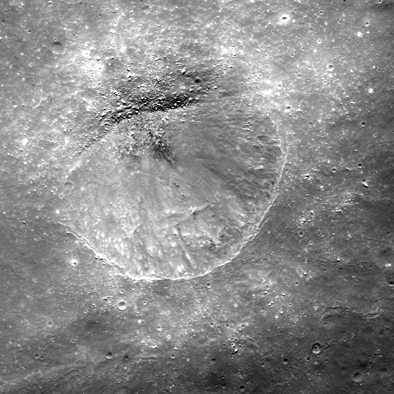
The northern flank of the dome partially covers the southern rim of a partially submerged pre-mare, impact crater (approx. 7 kms in diameter), which appears to have undergone subsidence to the east, where the craters wall is only visible as a feint 'ghost ring.' The height of the western rim is approximately 200 m above the mare surface, giving an indication of the vertical displacement affecting the eastern rim. This subsidence could be the consequence of crustal downwarp, but may also be a result of faulting, with the eastern wall being on the downthrow side of a north-south orientated fault. It is worth noting that a continuation of Rima Yangel to the west would intercept the crater rim at the position of the breach, though if this tectonic feature is related to the breach, it does not extend to the craters western rim. Evidence for subsidence or faulting is provided by the overall morphology of the dome and the rather 'off-center' appearance of the upper slopes relative to the apron as seen in Fig.1B with the apron to the west of an apparently greater extent than to the east. It is possible that if this apron was previously symmetrical, tilting would have lowered its level in the east with subsequent obscuration during the emplacement of the mare lavas, as is the case with the eastern crater rim.

Figure 1A and 1B - LROC (Arizona State University) Quickmap and NAC images show the effusive dome on the north edge of Mare Vaporum (A) and detail (B) showing possible vent complex (circled:B) and dark mantling (DM) on the ghost crater's southern wall. B: LROC NAC M181144987LR, LRO orbit 11810, January 14, 2012, scaled down from 1.3 meters per pixel resolution, from 128 km [NASA/GSFC/Arizona State University].
The dome itself appears to be divided into two distinct zones in elevation, the lower slopes comprising a relatively smooth textured debris apron of even albedo, and more rugged the upper slopes which appear to have a lower albedo surface layer overlying a subsurface of a higher albedo.

This may reflect mass wastage of the darker surface layers on steeper slopes to reveal either a fresh, low maturity soil beneath or soils of differing composition. The surface albedo of the northern flank appears lower than elsewhere on the dome, which may indicate the presence dark pyroclastic mantling deposit.

The summit of the dome is occupied by a number of rimless depressions, with the most conspicuous being roughly square in outline (approx. 400 m across) within which is a large smooth rimmed crater (approx. 150m diam). This square feature (Fig.2A) appears to be displaced slightly to the east of the dome summit, possibly as a result of subsidence which is discussed above. The square depression appears to be bounded by a fault scarp, whilst the smooth rimmed central crater within lacks a sharp rim, and may be of volcanic rather than an impact origin. This square depression and central crater may represent some form of vent complex.

The eastern side of the dome shows evidence of slope failure, with an arcuate scar cutting the upper eastern flank, beneath which the slope is modified by radial and sub radial grooves, possibly representing erosion gullies. This asymmetric slope failure affecting the eastern flanks may be related to the subsidence postulated above. This presumes that the dome was emplaced prior to any episodes of subsidence and therefore prone to de-stabilising slope modification occurring as a result.

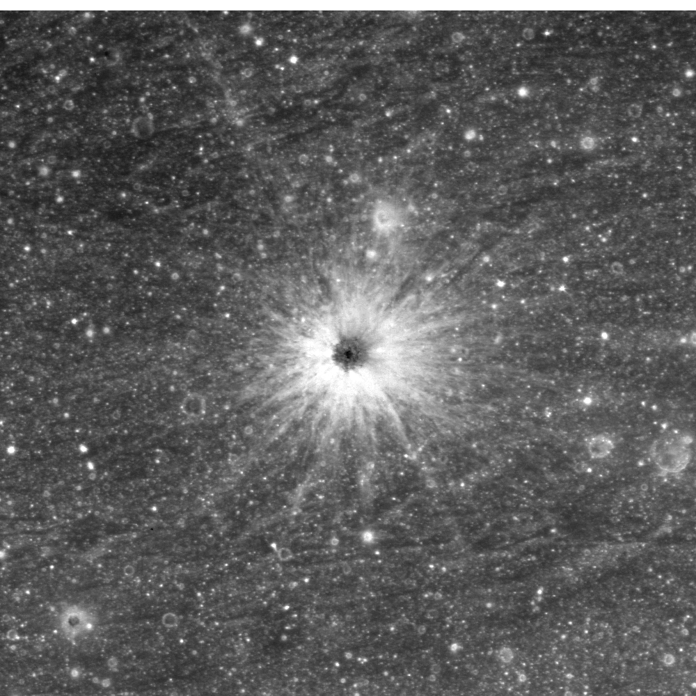
To the north of the dome and lying on the inner slope of the ruined crater wall is an area covered by a low albedo mantle. These low albedo deposits are patchy, with a darker surface layer overlying a lighter subsurface, again possibly as a result of exposure of fresh, immature material or material of a differing composition.

Figure 2A - Full resolution (40 cm) resolution detail of depression and crater within - LROC NAC M168183822LR [NASA/GSFC/Arizona State University].
Figure 2B - Under high Sun, dark mantle deposits on ruined ghost crater rim and wall with adjacent lighter boulder field. LROC NAC observation M1103545264LR, spacecraft orbit 14944, September 29, 2012, angle of incidence 20.62° at 1.02 meters resolution from 126.06 km [NASA/GSFC/Arizona State University].
This low albedo area is flanked to the west by a zone where the albedo of the inner crater wall is considerably higher. A detailed view reveals that it is composed of multiple, often superimposed boulder trails that appear to have originated from exposures along the upper margins of the inner crater wall (Fig. 2B). These trails form a boulder trail field with the boulders responsible visible in considerable numbers lying on the crater floor. It is possible that the low albedo dark mantled area was previously more extensive, but that a large area of it was disrupted during the formation of the boulder trail field. Evidence for this can be seen in the form of isolated patches of darker materiel within the boulder trail field, which may represent surviving remnants of the original mantling. The upper slopes of the dark mantled areas are largely clear of trails but isolated boulders are visible. In contrast the lower slopes do contain both trails and boulders. This may indicate that the lack of trails on the upper slopes reflect a later phase of localised dark mantling that obscured any trails that were present, but left the boulders responsible still visible. The existence  of these multiple boulder tracks indicate a significant ground disturbance that dislodged large numbers of boulders from the crater wall. This may be related to the subsidence or down-faulting discussed above, or to volcanically induced seismic disturbance during the active phase of the domes growth.

The Clementine UVVIS ratio enhances color differences related to soil mineralogy and maturity. The color ratio image is obtained assigning the R750/R415, R750/R950 and R415/R750 into the red, green, and blue channels of a color image, respectively.

Figure 3 - Inset: Clementine 750nm imagery with pyroclastic deposit. Surrounding context: Clementine false color of the region obtained assigning the R750/R415, R750/R950 and R415/R750 into the red, green and blue channels, respectively. The volcanic construct with pyroclastic deposits is marked with an arrow and renders as blue [NASA/USGS/DOD].
The lunar highlands are depicted in red (old) and blue (younger) and the maria are depicted in yellow/orange (iron-rich, lower titanium) or blue (iron-rich, higher titanium). The pyroclastic deposit is characterized by a different color respect to the nearby soil and appears blue indicating an increased TiO2 content (Fig. 3). The LPD has a lower 750 nm albedo of about 0. 092, while the examined mare unit is similar to that of the undisturbed crater unit with a 750 nm albedo of about 0. 011, but the LPD has a higher R415/R750 ratio, and is spectrally bluer than the other examined units with lower R415/R750 ratios of ~0.60.

For the spectral study the Multiband Imager (MI) on the Selenological and Engineering Explorer (Selene) with both visible and near infrared coverage in the spectral bands at 415, 750, 900, 950, 1000, 1050, 1250, and 1550 nm have been used. The spectral data were normalized using the region of Sinus Aestuum 2 site and calibrated using bidirectional reflectance corrected Keck 120 color spectral data for Sinus Aestuum 2. The color ratio image obtained with Selene-1 MI and assigning the R750/R415, R750/R950 and R415/R750 into the red, green, and blue channels of a color image, confirms the results found with the Clementine imagery but with higher spatial resolution. According to preceding findings the dark material extends beyond the dome itself into the flooded crater to the north, suggesting an ash type deposit and displays a blue color with a compositional contrast between the whole dome and the mare based on the UVVIS ratios imagery (Fig. 4).

Figure 4 - Ratio color image from SELENE-1 (Kaguya) dataset in which the R750/R415, R750/R950 and R415/R750 are assigned to red, green and blue channels, respectively. A slight contrast enhancement was applied to the RGB image [JAXA/SELENE].
We have applied the TiO2 and FeO estimation equations by Lucey et al. (2000)*. The derived values for FeO and TiO2 are then converted to Fe and Ti elemental abundance by multiplication for the factor (56/72) and (48/80) respectively, according to the atomic weights of the constituent elements. According to the Clementine and Selene-1 color ratio images, the Ti map indicates that the pyroclastic deposit has a Ti contents between 5.0 and 6.2 wt% corresponding to a high TiO2 content of 8.4-10.2 wt%. The elemental abundances of the mare units correspond to a lower Titanium content of 2.7-2.9 wt% (4.5 - 4.8 wt % as TiO2). The Fe map, obtained with the method described by Lucey et al. (2000), shows that the LPD has a Fe contents between 13.4 wt% and 14.0 wt% (17.7 wt% - 18.0 wt% as FeO), with a slightly lower Fe content in the nearby mare soil.

We also used the Chandrayaan-1’s Moon Mineralogy Mapper (M3) data between 460 to 3000 nm. For this work M3 data at a resolution of 140 mpp were calibrated and photometrically corrected and converted to apparent reflectance. These spectra are not thermally corrected, so they are not analyzed for wavelengths longer than 2300 nm as these have a significant thermal emission component. In order to characterize the 1000 nm band a continuum removal method that enhances the characteristic of the 1000 nm absorption band was used. We fit a straight line between 750 and 1500 nm to remove the continuum.

Figure 5 - Image of study area from M3 (Chandrayaan-1) dataset (Left). The LPD, the northern crater and mare unit east of the crater are marked. At right, M3 spectra of the examined units [NASA/ISRO].
Figure 6 - M3 spectra of the pyroclastic deposit located on the surface of the volcanic dome, previous described by the authors, HERE.
In the mare unit and in the pyroclastic deposit spectra weak inflections over 1000 nm are detectable, but we wouldn't regard this as an unambiguous identification of olivine, because M3 spectra of high-olivine soils show a much broader absorption.

The spectral signature of olivine has a wide band centered beyond 1000 nm, while the pyroxenes displays a narrow trough around 1000 nm, with a minimum wavelength below 1000 nm, and a wide absorption band around 2000 nm. Interestingly, the dark pyroclastic deposit has a narrower absorption (centered at 970 nm) than the mare unit, such that it cannot be enriched in olivine when compared to the mare. Probably the previously detected Clementine-specific olivine signatures are only partially due to olivine but also due to mis-calibration. Although the continuum-removed M3 spectrum of the crater seems to be noisy, it displays three absorption bands centered at 920, 970 and 1029 nm, likely due to admixed quantity of pyroxenes and olivine.

The effusive dome (center) lords over the northern extremes of Mare Vaporum in this view of the north central nearside captured on Earth (stacked CCD image) and processed by Astronominsk, May 31, 2009. Twenty-one kilometer wide Conon crater adds some scale to the area, scoured out by the Imbrium basin-forming-impact 3.8 billion years ago. Under sunrise illumination, the dome's true height can be seen clearly [Astronominsk].
The Christiansen Feature (CF) from Gridded data record (GDR) level 3 data product of Diviner Lunar Radiometer Experiment/Lunar Reconnaissance Orbiter (Diviner) data were used for further analysis. The Lunar Reconnaissance Orbiter’s (LRO) Diviner Lunar Radiometer Experiment has a spatial resolution of 950 m per pixel. Diviner produces thermal emissivity data, and can provide compositional information from three wavelengths centered around 8 µm that are used to characterize the Christiansen Feature (CF), which is directly sensitive to silicate mineralogy and the bulk SiO2 content. Silicic minerals and lithologies exhibit shorter wavelength positions at 8 µm channel. For the study area, CF values of 8 µm are towards longer wavelength (CF ~ 8.3 µm) indicating less silicic composition.

Email: Raffaello Lena <gibbidomine@libero.it>  Barry Fitz-Gerald <barryfitz_gerald@hotmail.com>

REFERENCE: Lucey, P. G., Blewett, D. T., Jolliff, B.L.  Lunar iron and titanium abundance algorithms based on final processing of Clementine ultraviolet-visible images, J. Geophys. Res., 105(E8), 20,297–20,305 (2000)

(*) Mapping FeO and TiO2 content

Classic approaches to the estimation of  FeO and TiO2 are based on the evaluation of Clementine UVVIS reflectance. Lucey et al (2000) derive the equation:

Wt % FeO = 17.427θFe – 7.565

where θFe is calculated according to: θFe = - arctan [(R950 / R750) – yFe / R750 – xFe] as the polar angle in the R950 /R750  vs. R750 diagram with respect to the reference point (xFe, yFe ) = (0.08, 1.19).

Similarly for the abundance of TiO2 Lucey et al. (2000) obtain the relation:

Wt % TiO2 = 3.708 (θTi )5.979 with θTi =  arctan [(R415 / R750) – yTi / R750 – xTi] as the polar angle in the R415 /R750  vs. R750 diagram with respect to the reference point (xTi, yTi ) = (0.0, 0.42)

Friday, March 22, 2013

Unveiling luna incognita: NSLI Seminar, April 15

USGS photometric map of the lunar south pole, updated through the Clementine (1994) mission, downloaded June 2009, one month before the launch of the Lunar Reconnaissance Orbiter (LRO). The blank regions were luna incognita, due to the geometry of earlier photography mission orbits or because they were within permanently shadowed regions. (Notably, these maps had not apparently been updated with the latest earth-based radar observation.) 17,000 orbits later, the LRO's suite of on-board instruments, together with skillful analysis of their collected data, have shed light on these last unmapped surfaces of the Earth-Moon system [NASA/USGS/DOD].
NASA Lunar Science Institute
NLSI HQ (Online) Seminar Series - Characterizing Luna Incognita
NOTE NEW DATE: Wednesday, April 15, 2013
9:00AM PST, 12:00 Noon EST, 16:00 UTC

NASA/NLSI
Ben Bussey
Applied Physics Laboratory
Johns Hopkins University

Abstract: When we began this integrated research project, the lunar Polar Regions were regarded as "Luna incognita", the unknown Moon.

During the last four years we have striven to further our understanding of the Polar Regions so that they are now as well known, and in some case better known, than the rest of the Moon. "Luna incognita" has become "Luna cognate":

* Study the geology of the poles
* Characterize the surface and subsurface properties
* Evaluate the ability to conduct surface operations, regolith excavation, and drilling
* Evaluate potential instrumentation for science conducted from and on the Moon

The goal of our team is to advance our scientific understanding of the Moon's poles and to fill in strategic knowledge gaps that facilitate the robotic and human exploration of these areas. One aspect that could not have been predicted is the wealth of new data that have become available since we began. These new data produced by an armada of spacecraft, including India's Chandrayaan-1, Japan's Kaguya mission, and NASA's LRO & LCROSS, provide new insight into the processes and history of the lunar poles.

Our results provide useful data for planning future lunar surface missions. For example we have located places near both poles that are constantly illuminated for several months around mid Summer.Such locations permit long-duration missions that do not have to survive periods of darkness. Also we have mapped regions of permanent shadow as far from the poles as 58° latitude. This new result drastically increases the opportunities for missions wishing to investigate if these areas contain volatiles, a useful resource for future robotic and human explorers.

A key aspect of our research has been collaboration. In addition to the natural collaboration between team members our work has benefited by the successful collaboration with other NLSI teams as well as other US and international scientists and engineers.

Nearly the same topography as we know the southern high-latitudes of the Moon four years and 17,000 polar orbits of LRO later. LROC Wide Angle Camera (WAC) interferometry with LRO LOLA laser altimetry, together with an improved understanding of the Moon's geode [NASA/GSFC/Arizona State University/DLR].
Biography: Ben Bussey is a planetary scientist at Johns Hopkins University Applied Physics Laboratory. He earned a BA in Physics from Oxford University and a Ph.D. in planetary geology at University College London before moving to the States. He gained both science and mission experience while working at the Lunar and Planetary Institute in Houston, the European Space Agency, and Northwestern University, before joining the Johns Hopkins University Applied Physics Laboratory where is the Assistant Group supervisor of the planetaryexploration group.

Ben's research concentrates on the remote sensing of the surfaces of planets, particularly the Moon. He has a particular interest in the lunar poles, producing the first quantitative illumination maps of the polar regions. He co-authored the Clementine Atlas of the Moon, the first atlas to map both the lunar near side and far side in a systematic manner.

In addition to being PI of a NLSI team he is also PI of the Mini-RF radar instrument on NASA's Lunar Reconnaissance Orbiter. This instrument, together with Arecibo telescope, is currently acquiring unique bistatic radar data to search for polar ice deposits.

He enjoys planetary analogue field work and has been fortunate to have twice ben part of the ANSMET (Antarctic Search for Meteorites) expedition to recover meteorites from the Antarctic glaciers.

Participation instructions if you cannot attend in person:

TO JOIN USING A WEB BROWSER: The slides and audio/video for this meeting will be presented using Adobe Connect. To join the meeting, connect to: http://connect.arc.nasa.gov/nlsi_directors_seminar/

TO JOIN USING A VIDEOCONFERENCING SYSTEM: Please RSVP to Ricky Guest (Ricky.Guest@nasa.gov) if you will be joining by Polycom or other standards based Video Teleconferencing System. There is no need to RSVP if you are only connecting via Adobe Connect.

To view the slides, connect to http://connect.arc.nasa.gov/nlsi_directors_seminar/

Wednesday, March 20, 2013

Saturn V artifacts recovered from Atlantic floor

One of five F1 engine thrust chambers from the Saturn V used to launch Apollo 11 to the moon on the bottom of the Atlantic Ocean. Image from Bezos Expeditions released March 20, 2013 [Bezos Expeditions].
Space.com has uploaded a 14 image slide show (available HERE) of Saturn V first stage salvage operations. The artifacts were discovered nearly a year ago far out off the coast of Georgia, under 4500 meters of water.

Related Posts:
Jeff Bezos finds Apollo 11-Saturn V First Stage (March 28, 2012)
Apollo 16 launch shrapnel found in North Carolina (July 12, 2011)

Landing Site at Tycho North (Science Concept 7)

A Ready-Made Landing Site?   One among many 'flash-frozen' impact melt ponds, a flow over the rugged ejecta immediately north of Tycho crater halted in place 109 million years ago. This one is 800 meters long along its north-south axis, and apparently level, nested about half the distance between the 1968 unmanned Surveyor 7 lander and a geologically interesting breach on Tycho's rim. LROC Narrow Angle Camera (NAC) observation M111668133RE, LRO orbit 1590, October 31, 2009; resolution 51 cm per pixel, angle of incidence 47.88° photographed from 49.39 km [NASA/GSFC/Arizona State University].
Second in a series of posts highlighting newly-proposed lunar landing sites selected to address high-priority science goals - from a remarkable landing site study published by the Center for Lunar Science and Exploration (CLSE):

Another image, less close-up, of the proposed 'Tycho North' landing zone, at slightly less granular resolution (0.65 meters per pixel), the nominally level melt pond is visible in greater context, nested in the rough and debris-strewn Tycho ejecta. The local slope runs from east to west but, overall, lower north and away from 86.2 km Tycho. From a mosaic, LROC NAC M106950070LR, spacecraft orbit 901, September 7, 2009; from 63.18 km altitude, angle of incidence 45.55° [NASA/GSFC/Arizona State University].
Joel Raupe
Lunar Pioneer

On February 5 we discussed a proposed landing site in Amundsen crater selected to support "Science Concept 4" as outlined in the commissioned National Research Council (NRC) study The Scientific Context for the Exploration of the Moon (2007).

In this second of a planned series we move to an area north of Tycho visited by Surveyor 7 in 1968. Material from the region was also very likely sampled by Apollo 17 in 1972, as Eugene Cernan and Harrison Schmidt explored Tortilla Flats in Taurus Littrow Valley, 2200 kilometers away.

While working with those same samples at the Johnson Space Center's Lunar Sample Laboratory Facility, Jack Schmidt soon helped estimate the age of samples collected at the base of South Massif directly opposite from Tycho at 109 million years. When the Tycho event happened, only 44 millions years remained before a similar impact ended the long reign of dinosaurs on nearby Earth. When offered as an example of the Moon's young craters the immense differences between terrestrial and lunar timescales and surface preservation rates are made stark. Such differences make it easy to forget that Earth and Moon have essentially shared the same location in the inner Solar System for 4.5 billion years (with Earth being a larger target and deeper gravity well). A study of the impact history and space weathering environment preserved on the Moon is a study of a much better preserved record of Earth's history.

This landing zone was proposed to address "Science Concept 7," a site that first presented to the Lunar and Planetary Science Conference in 2012 (Abstract #1387), from work produced by the Lunar & Planetary Institute Summer Intern Program the previous year. More detail emerged in the final CLSE landing site study of each of the NRC's 2007 lunar science goals, last fall. The LPSC 2012 abstract and contribution to the final CLSE study are credited to director David A. Kring and LPI 2011 interns Sarah Crites, Agata Przepiórka, Stephanie Quintana, Claudia Santiago and Tiziana Trabucchi.

"Science Concept 7" outlined in the National Research Council's NASA-commissioned Scientific Context for the Exploration of the Moon (2007). The Center for Lunar Science and Exploration (CLSE) released "A Global Lunar Landing Site Study to Provide the Scientific Context for the Exploration of the Moon" in late 2012, an exhaustive study of possible landing sites selected to address NRC 2007 lunar science concepts and goals [CLSE/LPI/NLSI].
The sites appearing in the new CLSE study might be broadly separated into two sets, ranked lists of many possible landing sites picked to fulfill all or overlapping part of the goals under the Science Concepts or individual targets picked in hopes of addressing all goals within one Science Concept and possibly overlapping with one or more of the other Concepts.

In other words, the ranks of possible landing sites in the new study range from those picked to accomplish much within practical, logistical and budget constraints over the next two decades to a long list of sites that may require 50 to 100 years to directly sample, along with a few lists falling somewhere in between. This might be a reflection of the political changes occurring over the years since the study began, when renewed exploration and establishing an extended human presence on the Moon went from being National Space Policy to falling by the wayside.

The new study is highly useful, regardless. Along with the Lunar Impact Crater Database, an even more detailed picture of the origins, ages and compositions of the Moon's complex features has been coming into focus, reflecting the astounding range of detailed information about the Moon collected in recent years.

Another full resolution LROC NAC view of the proposed landing zone, from a mosaic of the left and right frames of LROC NAC observation M111668133LR, LRO orbit 1590, October 31, 2009; incidence angle 47.82° from 49.39 km [NASA/GSFC/Arizona State University].
Since the goal is to establish definitive baselines, the actual ground truth of the upper few centimeters of the Moon's surface, why land near Tycho, the 86.2 km-wide astrobleme (41.49°S, 348.23°E) that is so much younger than its counterparts from earlier eras that have long faded into the albedo background? As it turns out, it's precisely because of such notably pristine.conditions, a comparatively youthful impact upon a region older than Mare Imbrium, that led Kring and his colleagues to seek this place out - along with proximity with Surveyor 7.

Understanding the dynamics of the upper few centimeters of the Moon's surface, most of which is turned-over, or "gardened" every couple of million years - involves more than dust mitigation or the charging and levitation of sub-micron dust as it interacts with radiation from the Sun and deep space or the Moon's nested crustal magnetic fields. Researcher will need a better understanding of this blasted layer of fine particles on wildly different timescales.

A really outstanding oblique view shows the proposed Tycho North Landing Zone from up over a spot 100 km west of Tycho, offerring even more perspective on the complex terrain surrounding the target melt pond (near center). Inset (see rectangle below) from an oblique (59° east of nadir) LROC NAC mosaic of from LROC NAC M1101317790, LRO orbit 14632, September 3, 2012 [NASA/GSFC/Arizona State University].
Thumbnail of the entire LROC NAC M1101317790RLR mosaic shows the area of the target melt terrace (the field of view in the immediately preceding full-resolution crop is framed by the yellow rectangle) in relation with Surveyor 7 and the rim of Tycho, 20 km south (to the right). Incredibly - at full resolution - the Surveyor 7 lander is actually visible in the full image. A proposed science station on the rim of Tycho is just outside this view at lower right [NASA/GSFC/Arizona State University].
Up, over and just beyond Tycho's 1200 meter high rim, the proposed LZ pictured above sits roughly at 620 meters elevation above the lunar geode (near 41.49°S, 348.233°E), the Moon's mean elevation, just out of sight from the sharp 800 meter drop down the crater wall (check this). The familiar crater's complex ejecta blanket extends 110 km from the central peaks, and its famous rays, visible to the naked eye, extend past 2000 km.

Beyond the debris piled high on the Tycho rim, the area of interest north by northwest of the crater, is characterized by slopes from 4.5 to 6° - safe for manned and unmanned landers. The specific Landing Zone is approximately 20 km from the rim fall off, where ancient pre-impact regolith appears to be exposed in layers visible in LROC NAC photography.

Because Tycho excavated pre-Imbrium nearside Southern Highlands, "any paleoregolith layers in Tycho's walls will also have a pre-Imbrium age," Kring and his colleagues note.

"Tycho's crater walls are the best target for sampling," though the upper reaches of the mountainous rim between the landing zone and the crater wall retain slopes greater than 25° "a navigable route to access layered deposits can probably be found."


Clementine multi-spectral mosaic color-coding overlaid on LROC Wide Angle Camera (WAC) 100 meter global mosaic shows the Science Concept 7 proposed landing site (arrow) is near the border between two widely different surface compositions [NASA/GSFC/DOD/ASU].
"The site provides access to regolith produced from substrates of different compositions (see image above)," from the coherent melt pond of the landing site itself to "rubbly ejecta... in a highlands area far from" the unique Procellarum, Potassium and Rare Earth (PKT, or 'Procellarum KREEP') terrain, covering so much of the nearside's west quarter.

Because the Tortilla Flats formation, sampled by Apollo 17, and nearby Surveyor 7 sampled materials related to the Tycho impact event "we can leverage these previous missions to compare properties of regolith of the same age formed from different types of ejecta."

Fifty km-wide LROC WAC field of view barely hints at the complexity of the terrain around the rim of Tycho. The suggested "Science Concept 7" landing site is an equidistant 10 km 'walk-back' distance (as the orbiter flies) from the 1968 landing site of Surveyor 7 (the last unmanned U.S. lander) and a suggested science station, a rare, dramatic breech in the sharp wall of the 'young' 109 million year old crater. The peninsula of melt piled into a comma below and to the right of Surveyor, was shown at very high resolution in "Giant Flow of Tycho Impact Melt," LROC Featured Image released August 14, 2012. LROC WAC (M168272917-9335CE) monochrome (643nm) mosaic   [NASA/GSFC/Arizona State University].
One of the best all-around LROC NAC images of Surveyor 7 (below left, arrow, and at full-resolution in the inset), from M150598504L, LRO orbit 7327, January 25, 2011; spacecraft and camera slew -15.17° from nadir, resolution 0.52 meters per pixel, angle of incidence 69° from 45 km. This roughly 300 meter wide field of view also includes another Tycho melt pond, the landing site Surveyor project manager Gene Shoemaker had hoped for as eventual landing site for this last vehicle of the program. The tripod lander's square sail, atop a supporting mast, casts a distinctive shadow [NASA/GSFC/Arizona State University].
Nearby Tycho's Rim - A possible breech in Tycho's high rim - within walking distance of the proposed Landing Zone, in the opposite direction from Surveyor 7 - may provide sampling access to the layered regolith visible above center-right. This angled corner on the north-northwest rim of Tycho was clearly modified very soon after the crater formed. Whether the slope below is too great to allow men and machines invaluable direct access to Tycho's equally interesting interior is still uncertain. LROC NAC mosaic M160029952LR   [NASA/GSFC/Arizona State University].
Some perspective to the proposed Science Concept 7 science station, on Tycho's rim (arrow) and the crater rim, wall and floor. Melt ponds dot the region. (In this oblique view, the landing zone and Surveyor 7 locations are outside this frame.) Still from video prepared from JAXA photography and data collected by the SELENE-1 (Kaguya) [JAXA/SELENE].
Establishing the rate and manner space weathering leads to the optical maturing (OMAT) of the Moon's surface will help researchers understand processes ranging from the interaction of reactive dust with crustal magnetism - the age and deposition rates of the Moon's swirl phenomena - the deposition of lunar volatiles and tighter estimates of the age of craters between one and two billion years old, past the time needed for optical maturity to do its work. 

Tycho, a recent rich excavation of the Moon's nearside Southern Highlands, and sights along a potentially valuable ingress to the crater's interior demonstrating the potential value of a single rather multiple expeditions. LROC WAC mosaic stitched from four sequential orbital overflights  LROC WAC (M168272917-9335CE) monochrome (643nm) mosaic   [NASA/GSFC/Arizona State University].
Remote sensing maturity maps hint the proposed landing site is characterized "by both very immature and intermediately mature soils," according to Kring and colleagues, "providing an opportunity to see the evolution of space weathering processes."
 
Proximity with Surveyor 7, about 20 km away, in the opposite direction from Tycho's rim, allows study of a known surface, and for a known amount of time (since 0600 UT, 7 January 1968), a stated goal in the NRC's 2007 commissioned report.
 
It's hoped the 20 km distance from the proposed landing site will prevent Surveyor 7, as a valuable 'long-duration exposure facility," from being undermined like Surveyor 3, ultimately swept clean by the descent of Apollo 12 only 183 meters away in 1969.Surveyor 7 may provide a "more pristine" baseline for measuring short-term space weathering.
 
The Tycho North landing site clear of any known crustal magnetism, free of space weathering processes both accelerated and slowed, as they appear to have been at Reiner Gamma, for example. Samples should therefore be "better representative of the lunar highlands."
 
The rate of solar-wind production of volatiles "can also be nicely calibrated here," Kring and his colleagues have noted, since "the exposure age is known and the orbital relationship between the Moon and the Sun is unlikely to have changed significantly over that period."
 
Chemical traces of the object that created Tycho Crater may be be found in the melt-rich rocks at the landing site, along with the shattered pieces of more distant and much older events in the 'recently' exposed paleoregolith uplifted in layers at Tycho's rim.

Some Related Posts:
Amundsen crater and the CLSE Landing Site Study (February 5, 2013)
Rippled Pond on Tycho's Wall (September 13, 2012)
Breached Levee at Tycho (September 11, 2012)
Giant Flow of Impact Melt (August 14, 2012)
River of Rock (June 20, 2012)
View from the Other Side (May 21, 2012)
Impact Melt Fingers (May 8, 2012)
Melt on a Rim (May 3, 2012)
Tycho Central Peak Spectacular (July 5, 2011)
Chaotic crater floor in Tycho (June 19, 2011)
Polygonal fractures on Tycho ejecta deposits (June 15, 2011)
Ejecta on slumped wall of Tycho (December 9, 2010)

When the Moon is full, Tycho's bright ray system is among the few lunar features visible to the naked eye. A testimony to its youth, a low degree of steady space weathering when compared to hundreds of similar but older crater,s from before the time when dinosaurs ruled the earth. The "miracle boys of Minsk" (Astronominsk) captured this local late morning image of Tycho, part of a full disk monochrome mosaic, captured from Belarus, September 20, 2010.  One of their fabulous color images of Тихо can be viewed HERE [Astronominsk].