Showing posts with label Lunokhod 1. Show all posts

Friday, November 22, 2013

A Great Place to Rove: Sinus Iridum and Chang'e 3

China will launch it's third unmanned lunar probe very early in December. Plans for Chang'e 3 include the first soft landing on the Moon since 1976 and the first rover since 1973. The China National Space Agency (CNSA) has long reported the target for this historic mission is Sinus Iridum, "the Bay of Rainbows," on the northwestern frontier of Mare Imbrium.

Meanwhile, following five years of planning, the NASA orbiter
LADEE has begun a 100 day examination of the Moon's tenuous exosphere, its formal science mission, in low equatorial orbit. It's all but certain both missions will be underway at the same time, leading some to jump to conclusions in reporting the two missions will interfere with one another. But, as Dr. Paul Spudis of the Lunar and Planetary Institute reports, nothing could be further from truth. Read his assessment, HERE.

-
Sinus Iridum
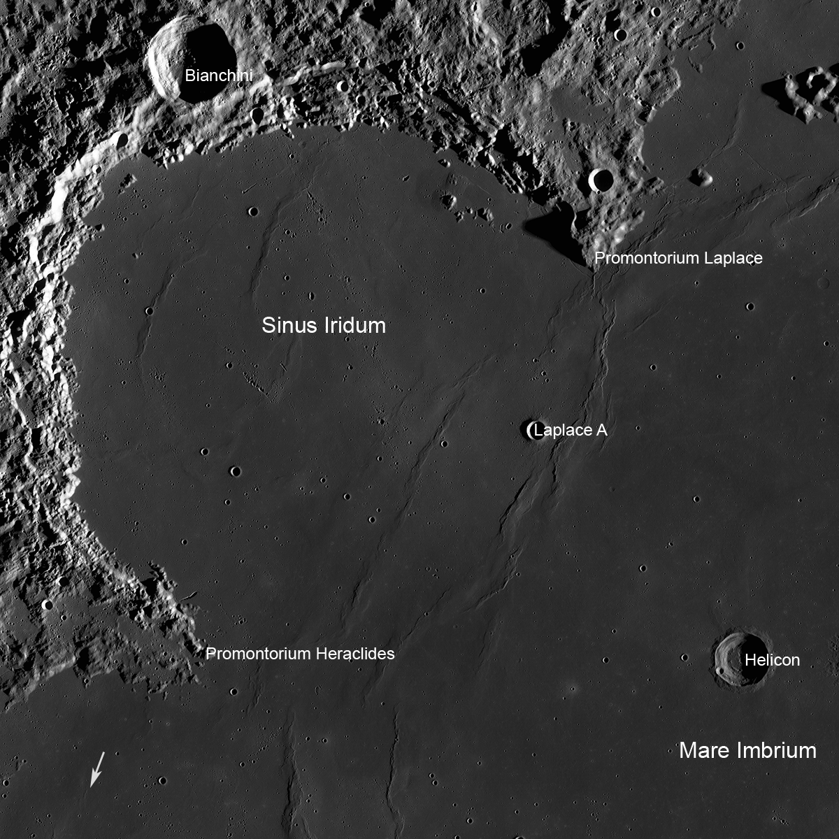
Sinus Iridum - it is likely China will land a rover near Laplace A before the end of 2013. (Arrow shows location of the Soviet Lunokhod 1), LROC Wide Angle Camera mosaic field of view 360 km [NASA/GSFC/Arizona State University].
Mark Robinson
Principal Investigator
Lunar Reconnaissance Orbiter Camera (LROC)
Arizona State University

In the near future China will attempt a robotic landing on the Moon, and will deploy a rover. The launch date and landing dates have not been officially announced. The exact landing spot is also not yet publicly designated, but it seems likely the landing will take place in Sinus Iridum, possibly near the fresh crater Laplace A (8 km diameter).

Why this particular spot on the Moon? Likely there are critical engineering constraints in terms of landing site selection as well as important science goals. And there is the dramatic grandeur of the lunar landscape!

Imagine the first rover-eye view from the crater rim - a sheer drop of 1600 meters at your wheels, and an 8 km view across to the far wall! From LROC NAC images we know rock is exposed in the upper walls and dramatic landslides streamed material down to the crater floor. Speaking of the crater floor - it hosts a now frozen lake of impact melt 2500 meters (1.5 miles) in diameter. Imagine the moments after the crater formed, the floor was a cauldron of molten rock with debris sliding down into the melt, and the crater itself was deforming as the floor uplifted after the initial pressure of the impact was relieved.

Laplace A and wrinkle ridge
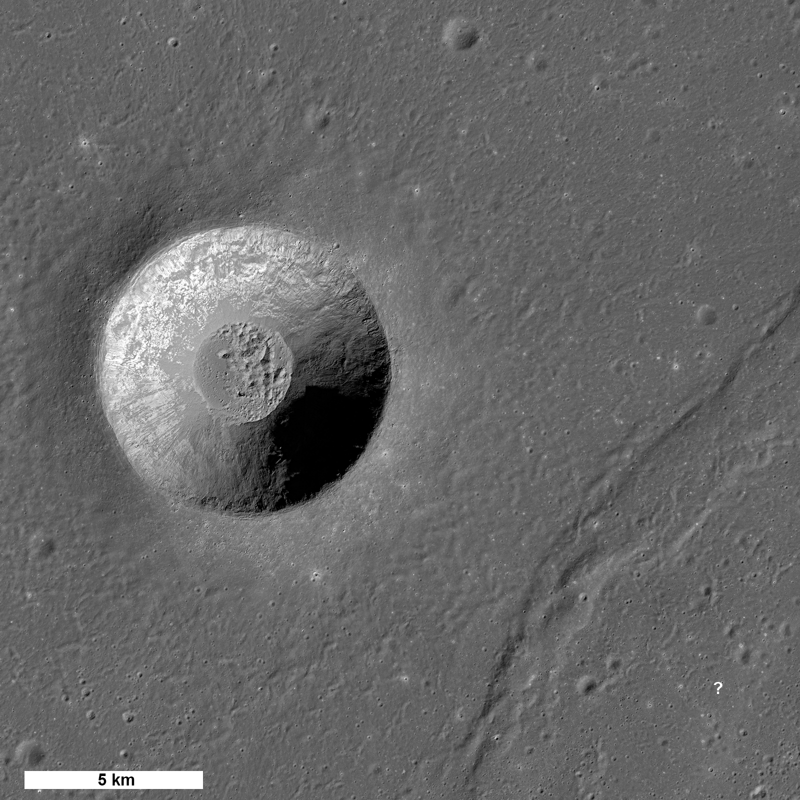
Laplace A crater and nearby wrinkle ridge (diagonally across at lower right). The question mark shows a potential landing site from which the rover could traverse northwest across the ridge to the edge of the crater [NASA/GSFC/Arizona State University].
Laplace A is a fascinating scientific target for a rover. It is a great example of a very young crater formed in mare basalt. A rover traversing the crater's ejecta blanket is in essence similar to driving down into the crater (in a geologic sense). We know from studies of terrestrial impact craters (such as Meteor crater) that material ejected from deep in a crater ends up near the rim, and rocks from the pre-impact surface are thrown far from the crater (a crater radius or more). So as a rover drives closer and closer to the rim it can characterize rocks from deeper and deeper below the surface.

Some of the many outstanding questions regarding the nature of the mare basalts include: how thick are individual flows, does the composition of the erupted magma change with time and location, and are pyroclastic (explosive) eruptions intermingled with effusive eruptions? These questions can be directly addressed with the Chang'e 3 rover! No humans or robots have ever visited a fresh crater anywhere near this size on the Moon (or Mars for that matter) so the return from this mission has great potential for advancing our knowledge of the Moon.

Laplace A
LROC NAC view of the interior of Laplace A crater [NASA/GSFC/Arizona State University].
But wait, there's more!

Another key question can be addressed: what is the 3D nature of large contractional ridges on the Moon? The rover is thought to have a ground penetrating radar (GPR) and it just so happens that a large wrinkle ridge (a contractional landform) lies about 10 km east of Laplace A. Although the exact mission plan is not publicly available, one potential scenario is that the lander sets down just east of the wrinkle ridge and deploys the rover. After initial testing of the lander and rover, and geologic characterization of the landing site, the rover could set off to the west towards the crater. As the rover drives up and over the wrinkle ridge the GPR would continuously probe the subsurface, slowly building up a 3D profile down to 100 meters or more (?) beneath the surface. Wrinkle ridges are complex landforms created when mare basalts are compressed, causing them to buckle and break along faults. However, wrinkle ridges have not been fully explored, and the  geometry and number of faults associated with each wrinkle ridge is not known. A subsurface profile of a wrinkle ridge could tell us the number of faults, where the faults are located, and how steeply the faults dip: is it 15°, 30° or 45°?

Chang-E-2-Laplace-A-900
Laplace A as plotted using photography and digital terrain model gathered from the CNSA orbiter Chang'e 2 [CNSA/CLEP].
From LROC images we have mapped the location of all the mare wrinkle ridges, and measured their surface topography, but all we have for the subsurface are models! Soon we may have actual measurements providing a good first step towards interpreting these poorly understood features. Wrinkle ridges are also found on Mercury and Mars, so better understanding a lunar example will help scientists unravel the tectonic story across the inner Solar System. Since only a handful of human and robotic missions have ever landed on the Moon, the results from the Chang'e 3 mission will provide important new scientific insights into our Moon.

Chang-e-2-CCD-LaPlace-full
Full resolution segment of the west wall and rim of Laplace A by Chang'e 2 [CNSA/CLEP].
Once Chang'e 3 has landed, LROC should be able to spot the lander and the rover; LRO will be above Laplace A on 25 December, 22 January, and 18 February.  The LROC team looks forward to posting images of the two vehicles!

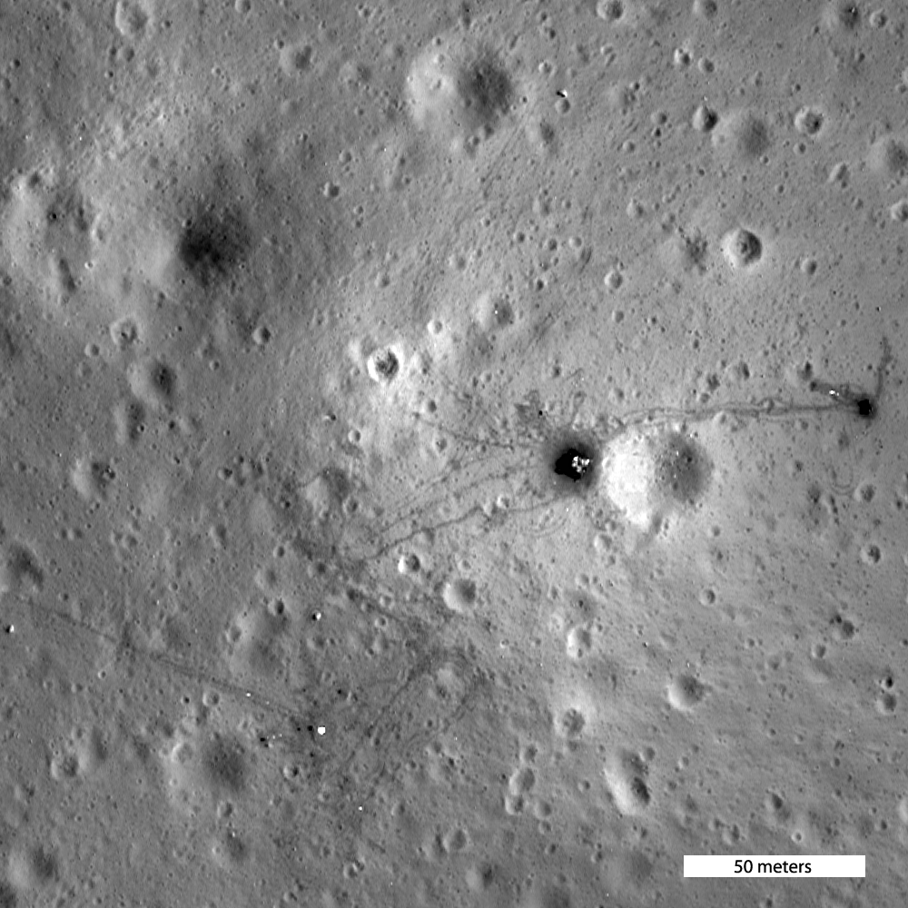
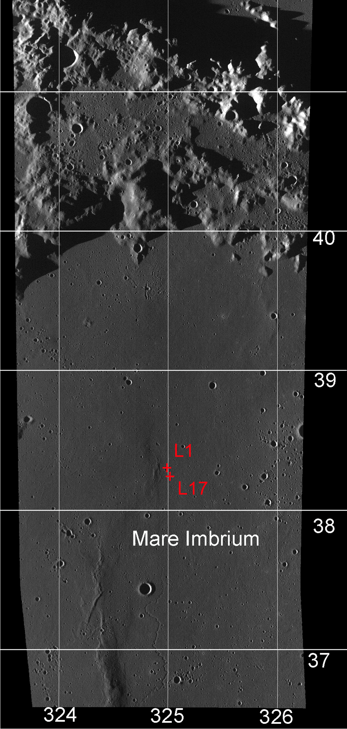
Coincidentally, Lunokhod 1 landed only 250 km to the southwest of Laplace A over forty years ago (17 November 1970). This intrepid Soviet rover explored for almost a year and traveled a total distance of 10.5 km. Both the lander vehicle (Luna 17) and the rover can be seen on the surface today.

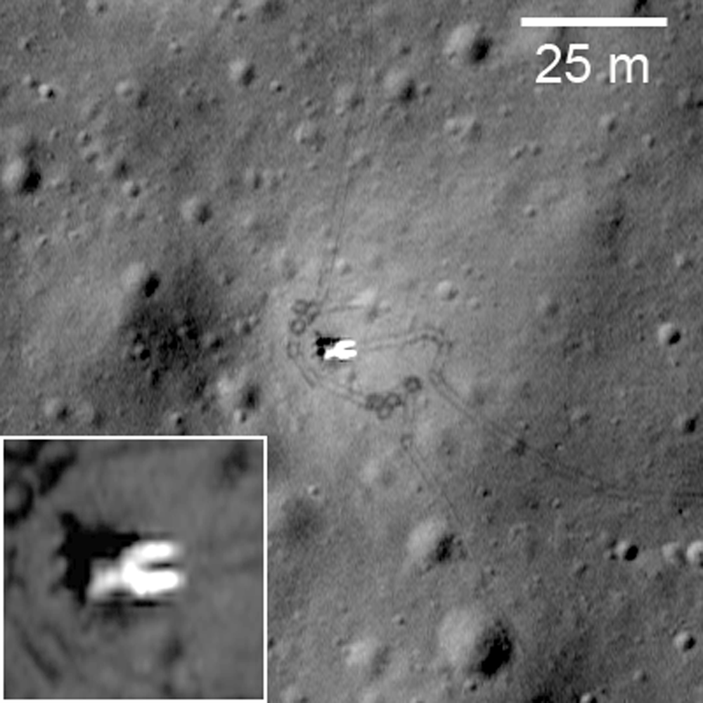
Perhaps the Chang'e 3 lander and rover will look something like this. Lunokhod 1 rover in its final parking place (38.315°N, 324.992°E) on the surface of Mare Imbrium, 250 km southwest of Laplace A. The Soviet rover, and its French-built laser range reflector array, were lost for four decades until relocated by LRO. The addition of the LLR to astrophysicists on Earth critically improved the accuracy of measurements of the distance to the Moon, bringing the uncertainty to within 3 millimeters. LROC NAC observation M175502049RE, spacecraft orbit 10998, resolution 33 cm per pixel. Original LROC Featured Image, HERE [NASA/GSFC/Arizona State University].
Explore the LROC Featured Mosaic of the Laplace region of interest, HERE.

Related Posts:
Lunar Laser Ranging: The Millimeter Range (November 19, 2013)
'Government landing penalty' removed from Google Lunar Xprize terms (November 7, 2013)
Chang'e 3 and LADEE: The Role of Serendipity, Paul Spudis (October 31, 2013)

Tuesday, November 19, 2013

Lunar Laser Ranging: The Millimeter Challenge

Lunar Laser Range Reflector arrays
The five Lunar Laser Range Reflector (LLR or LLRR) arrays deployed on the lunar surface, one each at the landing sites of Apollo 11, 14 and 15, and also to the Soviet rovers Lunokhod 1 and 2. The sublime accuracy of the decades-long measurements are priceless to astrophysics. Nearside view from "Synthetic View of the Moon," LROC Featured Image released October 15, 2013 [NASA/GSFC/Arizona State University].
T. W. Murphy, Jr.
Center for Astrophysics and Space Sciences
University of California

Lunar laser ranging has provided many of the best tests of gravitation since the first Apollo astronauts landed on the Moon. The march to higher precision continues to this day, now entering the millimeter regime and promising continued improvement in scientific results. This review introduces key aspects of the technique, details the motivations, observables, and results for a variety of science objectives, summarizes the current state of the art, highlights new developments in the field, describes the modeling challenges and looks to the future of the enterprise.

Since 1969, lunar laser ranging (LLR) has provided high-precision measurements of the Earth-Moon distance, contributing to the foundations of our knowledge in gravitation and planetary physics. While being the most evident force of nature, gravity is in fact the weakest of the fundamental forces, and consequently the most poorly tested by modern experiments. Einstein's general relativity, currently our best description of gravity, is fundamentally incompatible with quantum mechanics and is likely to be replaced by a more complete theory in the future. A modified theory would, for example, predict small deviations in the solar system that, if seen, could have profound consequences for understanding the universe as a whole.

Utilizing reflectors placed on the lunar surface by American astronauts and Soviet rovers, LLR measures the round-trip travel time of short pulses of laser light directed to one reflector at a time. By mapping the shape of the lunar orbit, LLR is able to distinguish between competing theories of gravity. Range precision has improved from a few decimeters initially to a few millimeters recently, constituting a relative precision of 10-9 through 10-11. Leveraging the raw measurement across the Earth-Sun distance provides another two orders of magnitude for gauging relativistic effects in the Earth-Moon-Sun system.

The largest of the Apollo lunar laser range reflectors (LLRR) arrays, deployed at Hadley Rille by Scott and Irwin of the Apollo 15 surface expedition in February 1971. The instrument is still a regularly acquired critical part of on-going experimental astrophysics. AS15-85-11468 [NASA/JSC].
As LLR precision has improved over time, the technique has remained at the cutting edge of tests of gravitational phenomenology and probes of the lunar interior, and has informed our knowledge of Earth orientation, precession, and coordinate systems. LLR was last reviewed in this series in 1982; this update describes the key science drivers and findings of LLR, the apparatus and technologies involved, the requisite modeling techniques, and future prospects on all fronts.

Lunokhod 1 rover in its final parking place (38.315°N, 324.992°E) on the surface of Mare Imbrium. LROC Narrow Angle Camera (NAC) observation M175502049RE, orbit 10998, November 9, 2011, resolution 33 cm per pixel. View original Featured Image released March 14, 2012 (with enlarged inset) HERE [NASA/GSFC/Arizona State University].
LLR is expected to continue on its trajectory of improvement, maintaining a leading role in contributions to science. Other recent reviews by Merkowitz (2010) and by Muller, et al. (2012) complement the present one. The Merkowitz review, like this one, stresses gravitational tests of LLR, but with greater emphasis on associated range signals. Next-generation reflector and transponder technologies are more thoroughly covered. The Muller et al. review (for which this author is a co-author) covers a more complete history of LLR, has statistics on the LLR data set, and provides greater emphasis on geophysics, selenophysics, and coordinate systems.

This review is organized as follows: Section 1 provides an overview of the subject; Section 2 reviews the science delivered by LLR, with an emphasis on gravitation; Section 3 describes current LLR capabilities; Section 4 relates recent surprises from LLR, including the finding of the lost Lunokhod 1 reflector and evidence for dust accumulation on the reflectors; Section 5 treats the modeling challenges associated with millimeter-level LLR accuracy; and Section 6 covers possible future directions for the practice of LLR.

Wednesday, September 25, 2013

LROC updates image tally of human artifacts on the Moon

Luna 17, the spacecraft that carried the Lunokhod-1 rover to the surface of the Moon; debarking ramps for the rover tracks around the lander are visible, extending southeast, to the right. LROC Narrow Angle Camera (NAC) frame M175502049RE, LRO orbit 10998, November 9, 2011; angle of incidence 57.78° at 43 cm per pixel resolution from 30.66 km over 38.23°N, 325.01°E. View the original contextual image with an enlarged inset HERE [NASA/GSFC/Arizona State University].
Samuel Lawrence
LROC News System

Repeat imaging of anthropogenic targets on the Moon remains an LROC priority as the LRO Extended Science Mission continues. These continuing observations of historic hardware and impact craters are not just interesting from a historical standpoint - each image adds to our knowledge of lunar science and engineering, particularly cartography, geology, and photometry.

Making sure that the lunar cartographic network is accurate is a critical component for planning future lunar missions for both human and robotic exploration of the Moon. The historic spacecraft serve as benchmarks (especially the laser retroreflectors). When new images arrive and final ephemeris is in hand we can check if the hardware has moved - well, actually we see the level of uncertainty in computing latitude/longitude coordinates (currently about ±15 meters).

View of the Luna 17 lander from the Lunokhod-1rover (the vehicle descended from its position atop the lander from the opposite side). A wide variety of images, including many other firsts from the Soviet Union's lunar exploration program  of the Cold War era can be viewed HERE.
Currently the United States has no near-term plans to land humans or robotic spacecraft on the Moon, however China is scheduled to launch the Chang'e 3 mission in December. If we are lucky, the LROC team might have a before picture to compare to any after pictures of the Chang'e 3 landing site (the exact planned landing coordinates have not yet been released). Currently all LROC NAC investigations must rely solely on "after" images of landing sites. Obtaining a before and after set of images of the Chang'e 3 will facilitate a much better understanding of the delicate processes involved in regolith redistribution due to lander rocket plumes.

When a spacecraft lands on the Moon in a powered descent, exhaust gases from the descent engine disrupt the surface resulting in visible changes around the landed vehicle. These changes can be better understood with photometric studies using using LROC NAC images taken with different illumination geometries. Close to (or right under) the lander the soil is most disrupted, leading to reduced reflectance. Interestingly a zone of increased reflectance surrounds the lander. This "blast zone" ranges from a few meters for the Surveyor spacecraft, to a few tens of meters for Luna, and a few hundred meters for Apollo.

The Apollo 15 landing site through shifting shadows of a simulated lunar day, courtesy of the LROC Featured Sites Index. Very little appears to have changed since the departure of Scott and Irwin nearly 600 lunar days ago [NASA/GSFC/Arizona State University].
Photometric modeling indicates possible causes for the increased reflectance zones from smoothing of the surface by the exhaust flow, the destruction of micro-scale regolith structure, and/or the redistribution of fine particles from the area beneath the lander to its surroundings. Modeling the dynamics of rocket exhaust plumes and studying the exhaust plume effects of previous landed spacecraft on the Moon are defining safe operational practices for future landing sites and outposts.

Exceptionally detailed photograph of the Ranger 9 impact on the floor of Alphonsus crater appears to include an inner disk of darker material around 10 meters across, possibly melt created by the release of kinetic energy, LROC NAC M170579736R, LRO orbit 10272, September 13, 2011; angle of incidence 16.1° at 49.6 cm per pixel resolution from 44.64 km [NASA/GSFC/Arizona State University].
Selection of spacecraft impact sites imaged from LRO using the LROC twin Narrow Angle Camera instrument, all at the same scale [NASA/GSFC/Arizona State University].
Careful retracing of the Lunokhod 2 traverse dramatically improved our understanding of the surface activities of that intrepid rover. In addition, by accurately determining the locations of the Luna 23 and Luna 24 landers, the LROC team determined not only how the Luna 23 spacecraft failed, but also that the Luna 24 sample was collected on the rim of a small impact crater, providing an explanation for the discrepancies that existed for the past three decades between samples and remote sensing of the Mare Crisium surface.

Check out a map of robotic spacecraft sites on the lunar surface, HERE.

(a) listing of coordinates (mean Earth/polar axis (ME) system) of ... Soviet and American robotic space hardware and craters produced through spacecraft impact (thus far) identified by the LROC Team can be download as an Adobe PDF file is available HERE.

ED NOTE: This is at least a partial update to "Coordinates of Robotic Spacecraft," released April 9, 2010.

To generate the list of observed latitudes and longitudes, we compiled a list of line and sample coordinates for the center of each object in each image. Each image was then initialized using the USGS Integrated Software for Imagers and Spectrometers (ISIS) software package, attaching the appropriate spacecraft position and pointing information, along with the GLD100 lunar shape model for elevation. ISIS routines were then used to compute the latitude and longitude of the spacecraft (or impact crater) in that image.

The LRO spacecraft positions on the list were provided by the latest cross-over corrected spacecraft positioning kernels provided by the LRO LOLA Team, with an orbital position uncertainty of 15 meters. Finally, temperature-corrected NAC camera kernels produced by the LROC team contributed to the high precision and accuracy. The coordinates listed in the table are statistical median from all of the images acquired before April 28, 2013 for a particular site.

Related Posts:
Apollo 12 at 43 Years (November 20, 2012)
Taurus Littrow Oblique (September 29, 2012)
Close-up on the lonely trail of Lunokhod-2 (September 17, 2012)
America's last unmanned lunar lander (September 7, 2012)
"Houston, Tranquility Base here" (August 28, 2012)
Scooping the Soviets (August 8, 2012)
Apollo 15 departs Hadley Rille Delta - 41 years ago (August 2, 2012)
Tranquility Base at high-resolution before Apollo 11 (August 2, 2012)
Ranger 8 impact on restored Lunar Orbiter LOIRP photograph (July 31, 2012)
"O! Say can you see, by the dawn's early light" (July 27, 2012)
New tool for exploring LROC images and Apollo landing observations (July 19, 2012)
Craters bear Lunokhod-1 officially named (July 3, 2012)
Astronaut's eye view of the Apollo 16 landing site (June 19, 2012)
Who discovered water on the Moon (June 1, 2012)
Will China deploy the first lunar rover since 1976? (April 30, 2012)
The discarded extension of the Ranger program, David S.F. Portree (April 30, 2012)
Orion, up close (April 24, 2012)
Forty years ago, 'a big ol' Navy salute' (April 21, 2012)
Forty years ago-Apollo 16 (April 21, 2012)
The Last Sampler: Failure, then Success (March 17, 2012)
Lunokhod-1 revisited, too (March 15, 2012)
Lunokhod-2 revisited (March 13, 2012)
Pinpoint Landing on the Moon - Apollo 12 (March 12, 2012)
How Young is Young? - Apollo 16 (March 9, 2012)
LROC's closest look yet at Tranquility Base (March 8, 2012)
Apollo 12 and its pinpoint landing in the Moon (March 7, 2012)
Follow the tracks - Apollo 15 (March 6, 2012)

From the second of two sequential, exceptionally low periapsis orbital passes, allowing the LROC team at Arizona State University to capture breathtaking views of the Apollo 16 landing site in the nearside Southern Highlands, LRO orbit 10950, November 6, 2011; LROC NAC M175179080, field of view 145 meters, released on the 40th anniversary of the lift-off from the Moon of the Young and Duke expedition, April 22, 2012 [NASA/GSFC/Arizona State University]

Just another crater? (December 13, 2011)
"Boy, that sure looks like Luna 9!" (December 3, 2011)
Cernan says China will be first back to the Moon (November 8, 2011)
Hadley Rille and the Mountains of the Moon (November 8, 2011)
The First Race to the Moon, David S.F. Portree (September 27, 2011)
On the run! - Apollo 14 (September 8, 2011)
New Views of Apollo 12 (September 8, 2011)
Apollo 14 at 25 cm per pixel (September 8, 2011)
Skimming the Moon (September 8, 2011)
LRO Briefing: Latest Close-Ups of Apollo Sites (September 6, 2011)
Low altitude views of Apollo released (September 3, 2011)
First Low Altitude Apollo 12 NAC Image (August 11, 2011)
Crash or Coincidence (July 22, 2011)
Surveyor 7 (February 12, 2011)
New View of Apollo 14 (February 4, 2011)

Surveyor 7: Our Fragile Lunar LDEF (October 27, 2010)
LRO analysis of LCROSS data proves essential (October 21, 2010)
LRO transitions from exploration to science (September 16, 2010)
Apollo 16, Footsteps Under High Sun (July 11, 2010)
Too brief an expedition to a lobate scarp (August 24, 2010)
Re-acquisition: Lunokhod-1 (April 27, 2010)
Apollo 16: 38 years on (April 21, 2010)
Retracing the steps of Apollo 15: Constellation ROI (April 17, 2010)
Value-added LROC (April 16, 2010)
A fundamental point on the Moon (April 13, 2010)
The part of Apollo 13 that made it to the Moon (April 12, 2010)
Coordinates of Robotic Spacecraft (April 9, 2010)
Ranger 9 (April 4, 2010)
Absentee ownership of Lunokhod-2 (April 1, 2010)
LOLA's Tycho and the Apollo era (March 28, 2010)
The first successful robotic sampler, Luna 16 (March 26, 2010)
Apollo 13 SIVB impact (March 23, 2010)
Surveyor 5: A Hole-in-One (March 21, 2010)
Surveyor 6 on the plains of Sinus Medii (March 21, 2010)
Luna 21 Lander (March 19, 2010)
Foot fall around Orion in the mid-day glare (March 19, 2010)
Lunokhod-1 and Lunokhod-2 (March 17, 2010)
The Soviet lunar sampling missions (March 16, 2010)
Alan Bean shares Apollo 12 with community college students in Iowa (March 9, 2010)

The largest of three Apollo lunar laser range reflectors (LLRR), deployed at Hadley Rille by Scott and Irwin of Apollo 15 in February 1971. The instrument is still an active, critical component of on-going experimental science, part of the effort to further constrain the measured distance to the Moon (to within 3 mm) in part determine "locality," if any, of the laws cosmological physics. AS15-85-11468 [NASA/JSC].
Triumph (and disappointment) of Apollo 12 (November 19, 2009)
High Noon over Apollo 11 on YouTube (November 14, 2009)
Midday on Oceanus Procellarum: Apollo 12 (November 5, 2009)
Apollo 12 Second Look: Midday on the Ocean of Storms (November 4, 2009)
Apollo 17 from 50 kilometers (October 28, 2009)
When bombing the Moon was a good idea (October 21, 2009)
Apollo 14 SIVB impact (October 8, 2009)
Lonely Sentinel Abides (October 1, 2009)
Surveyor 1: America's first soft lunar landing (September 30, 2009)
Tranquility Base: a better, second look (September 29, 2009)
Shadow on the Moon (September 24, 2009)
LROC zooms in on Apollo 12 and Surveyor 3 (September 4, 2009)
First Look: Apollo 12 and Surveyor 3 (September 3, 2009)
Lasting boot prints from 1971 (August 21, 2009)
Trail of Discovery at Fra Mauro (August 19, 2009)
The continued importance of lunar laser ranging (August 3, 2009)
Rediscovering Tranquility Base (July 19, 2009)
Five Apollo landing sites photographed (July 17, 2009)
Lunar Orbiter III-154-H2 (LOIRP) (June 16, 2009)
LOIRP recovers early image of Ranger 8 impact (June 9, 2009)
Kaguya to impact June 10 (May 21, 2009)
Chang'e-1 controlled impact in Mare Fecunditatis (March 1, 2009)
More astounding detail (Surveyor 1) from LOIRP (February 26, 2009)
Anniversary of Ranger 8 (February 20, 2009)
Surveyor proved the Moon safe for man (January 4, 2009)

Chandrayaan-1 Moon Impact Probe shoots Shackleton (November 15, 2008)
Tranquility Base from Kaguya (SELENE-1) (March 29, 2008)

Tuesday, July 3, 2012

Craters near Lunokhod-1 officially named

Luna 17, the lander that carried Lunokhod 1 to the surface; debarking ramps for the rover visible extending down to the surface to the right. Many rover tracks are visible around the lander and throughout LROC Narrow Angle Camera (NAC) frame M175502049RE, LRO orbit 10998, November 9, 2011. View the original contextual image with enlarged inset, HERE [NASA/GSFC/Arizona State University].
Olga Zakutnyaya
The Voice of Russia
 

A number of moon craters in the vicinity of Lunokhod–1 lunar rover have been given their own names. They were named in honor of the crew members of the first self-propelled vehicle on the surface of the celestial body.

The experiment carried out more than 40 years ago is to be repeated in the course of “Luna-Resource” expedition which should be launched no earlier than 2015.

The International Astronomical Union has approved 12 new names for small craters on the Moon, and now they have names of the members of the first lunar expedition and scientists who were involved in the project. Despite the fact that these people were not able to walk on the Moon’s surface themselves, they were the ones who led Lunokhod–1 – the first planet rover on the surface of an alien celestial body. All craters are located in the area of the “Sea of Rain” (Mare Imbrium) where the landing vehicle of Luna-17 interplanetary automatic station soft-landed in November 1970. It delivered Lunokhod lunar rover onto the Moon’s surface. All craters are comparatively small, their diameter ranging from 100 to 400 meters.

Thus, the names of Albert, Borya, Gena (in honor of the navigator Gabdulkhai Latypov), Igor, Kolya, Kostya, Leonid, Nikolya, Slava, Valera, Vasya, and Vitya appeared on the Moon.

The Luna-17 spacecraft was built by the design and construction bureau of the machine-engineering plant named after S.A. Lavochkin (now NPO Lavochkin). Lunokhod-1 was equipped with a set of scientific devices to explore the lunar soil. In the course of 10 months that it was working on the Moon, the rover traveled over 10.5 kilometers and sent back to Earth information about the mineral composition and characteristics of the lunar surface.

Lunokhod 1 rover in its final parking place (38.315°N, 324.992°E) on the surface of Mare Imbrium. LROC Narrow Angle Camera (NAC) observation M175502049RE, orbit 10998, November 9, 2011, resolution 33 cm per pixel. View original Featured Image released March 14, 2012 (with enlarged inset) HERE. [NASA/GSFC/Arizona State University].
Lunokhod-1 was controlled remotely via the center for space communications by two crews – five people each who worked in shifts. Each crew consisted of a commander, a driver, a navigator, a flight engineer, and a high gain antenna operator. Thus there were 10 people all together, plus a reserve driver and reserve high gain antenna operator.

Even though by the time Lunokhod-1 was launched American astronauts had already landed on the Moon, the soviet rover was no less a remarkable scientific and technical achievement. Unfortunately, at that time, the meaning of this achievement was overshadowed by the defeat in the race to put a man on the moon. Lunokhod-1, with all its novelty and complexity, was more of a consolation prize. At least that was the general attitude – and analysts might object, of course. Sadly, it was what determined the further development of the lunar program. After the improved version Lunokhod-2 in 1973, there was Lunokhod-3 which never made it to the Moon. As a result, the Lunar Program of the USSR was suspended. Forty years on there has been little progress.

Today it can be said that it was a mistake. Weak consolation might be the fact that space programs in other countries primarily in the United States have also been suspended. However, the comparison might not be accurate – paradoxically as it may sound as though the soviet moon explorations at the end of the “manned moon race” were in a better state (if not financially from the strategic point of view). A continuation of manned expeditions demanded huge resources and clear goals, which probably did not exist at that time. Autonomous expeditions were easier from the point of view of their preparation but brought back much more scientific results. Besides, by that time, complicated initial stages with lots of failures were overcome and so reliability was higher.

Far western 1970 Landing Zone of the Soviet Union's Luna 17, and the final parking spot of the first remote-operated lunar rover, Lunokhod-1. The French-built laser reflector array deployed from the Lunokhod eluded detection for four decades until its precise location was reacquired by the LROC Narrow Angle Camera in 2009. It's relocation added vital precision to measurements of the Earth-Moon distance that may answer important questions in astrophysics. LROC Wide Angle Camera 100 meter Global Mosaic overlaid upon LOLA topography and assembled using the NASA LMMP ILIADS application [NASA/GSFC/LMMP/Arizona State University].
Something similar is happening to NASA’s Mars exploration program. A long and ongoing exploration of the planet with more and more sophisticated and complex tasks resulted in the fact that the US became a true leader in the Mars programs. That was, in fact, the main argument by scholars who objected to cuts in NASA’s planetary space budget in 2013. In their opinion to lose such an important scientific and technical foundation would be a poor strategic move.

The current plans of Russia in the area of space exploration include returning to the Moon with landing vehicles and a mini-rover – a self-propelled machine which is being developed by an Indian organization for the purposes of the Luna-Resource program. It is planned to repeat lunar soil collection considering previous experiences. If in the course of the first expeditions the soil was collected only in the places of landing – now the goal is to combine the operation of the mini-rover and returning spacecraft. The mini-rover is to determine the most interesting spots and collect soil from them and then the spacecraft should return the samples to the Earth.

New Names Approved for Twelve Small Lunar Craters - The Working Group for Planetary System Nomenclature has approved 12 new names for small craters on the Moon: Albert, Borya, Gena, Igor, Kolya, Kostya, Leonid, Nikolya, Slava, Valera, Vasya, and Vitya. For details, see the map of LAC 24 and the Lunokhod-1 traverse map in the Gazetteer of Planetary Nomenclature [USGS].
Yet as of now these are only plans. Information from the Moon is coming daily. NASA LRO and GRAIL spacecraft continue to work in the Moon’s orbit (two spacecraft which measure lunar gravity fields). Several days ago, the NASA LRO mission published recent images of the lava fields formed as a result of asteroid impacts. The images were taken by LROC – Lunar Reconnaissance Orbiter Camera. This camera is also connected to the Lunokhods – in 2010, the first high resolution images were printed and it was possible to see Lunokhod-1 and the landing spacecraft and the wheel tracks. Interesting that in the same year a group of American scientists announced that they had managed to intercept a pulse from a laser retroreflector on Lunokhod-1.

It is probable that these circumstances have raised the interest in the Lunokhod program again. Naturally, recognition of the achievements of the soviet scientists is satisfying on the one hand, but on the other the interest is mostly coming from western institutions and space lovers. Without the LROC images, the “favourite lunar tractor” would be remembered only by those who are truly loyal to space science. That is why one of the tasks of the future lunar program is not only to learn again how to land and control spacecraft on the Moon, but also how to inform people about it in plain language, and on a regular basis.

Related: Lunokhod-1 revisited (March 15, 2012)

Thursday, March 15, 2012

LROC: Lunokhod 1 revisited, too

Lunokhod 1 rover in its final parking place (38.315°N, 324.992°E) on the surface of Mare Imbrium. LROC Narrow Angle Camera (NAC) observation M175502049RE, orbit 10998, November 9, 2011, resolution 33 cm per pixel. View original Featured Image with enlarged inset HERE. [NASA/GSFC/Arizona State University].
Jeff Plescia
LROC News System

Luna 17, carrying Lunokhod 1, landed on the flood basalt surface of Mare Imbrium on November 17, 1970, after entering orbit on November 15. 

Today's Featured Image of Luna 17 and Lunokhod 1 was obtained during a low altitude (33 km) pass providing the highest resolution view yet of the landing site.

The same LROC Narrow Angle Camera frame captured both the lander and the Lunokhod 1 lunar rover, and nearly all the wheel tracks the rover left behind, just shy of 42 years afterward.

Luna 17, the lander that carried Lunokhod 1 to the surface; debarking ramps for the rover visible extending down to the surface to the right. Many rover tracks are visible around the lander and throughout LROC NAC frame M175502049RE. View the original contextual image with enlarged inset, HERE [NASA/GSFC/Arizona State University].

Artist’s conception of Luna 17 on the lunar surface, with Lunokhod descending to the surface [Anatoly Zak/Russian Space Web].
Once Luna 17 landed, ramps were deployed on two sides of the lander allowing for two possible directions for the rover to drive to the surface. In this case, the rover drove down the ramps on the east side of the lander. Rover tracks can be seen extending away from and around the rover. Also note the bright area around the Luna 17 lander; the surface was modified by the exhaust gases from the descent engines such that it appears brighter. This increased contract makes the rover tracks more obvious near the lander.

View of the Luna 17 from the Lunokhod 1. The rover descended from the lander on the opposite side. The wide variety of images, including many other firsts, from the Cold War era Soviet lunar program can be viewed HERE.

Lunokhod 1 traveled a total distance of 10.5 km. It was first commanded to drive south from the Luna 17 lander, making a loop across the mare surface, and then returning north to Luna 17. The rover was then directed to proceed farther north, making a small loop to the west, then returning to its track and continuing northward. The payload consisted of a suite of television cameras, a cone penetrometer to determine physical properties of the regolith, and an X-ray spectrometer to determine the chemistry of the regolith. An X-ray telescope and cosmic ray detector were also part of the payload.

Like Lunokhod 2, Lunokhod 1 carried a French-built laser retroreflector. The vehicle was tracked for a short period during the mission then lost. Once the vehicle was located using LRO/LROC images by the LROC team, it was targeted and recovered using the lunar lasers at the Apache Point Observatory. Because of its location away from the Apollo retroreflectors and Lunokhod 2, recovering Lunokhod 1 is important for lunar geophysical studies.

The rover’s journey across the surface formally ended on October 4, 1971, after 11 lunar day-night cycles (322 Earth-days). Attempts to contact the rover after the lunar night that began on September 14, 1971 were unsuccessful, apparently due to a failure of some component of the rover during the lunar night.

Northern Mare Imbrium showing the location of the Luna 17 landing site and the final position of the Lunokhod 1 rover. View the larger LROC WAC context image HERE. [NASA/GSFC/ Arizona State University].

Explore the Lunokhod 1 site on your own HERE.

Revisit about the earlier LROC "rediscovery" of Lunokhod 1 HERE.