Tuesday, April 29, 2014

Jagged rim on the southwest limb

The upper southeastern rim of Piazzi H (8 km; 40.185°S, 294.237°E) 800 meter field of view from LROC NAC observation M1152277932L, LRO orbit 21794, April 16, 2014; 59.17° incidence angle, resolution 75 cm from 72.25 km [NASA/GSFC/Arizona State University].
Raquel Nuno
LROC News System

The rocks that form Piazzi H's (40.185°S, 294.237°E) beautifully textured upper crater wall hang precariously from near the crater rim. Under the action of gravity and time, material from crater walls continuously slough off. This fall to a lower gravitational potential is one of the reasons why old craters have a smoother appearance (the other reason is bombardment by micrometeorites which pulverize craters into fine grained dust). 

Why do these overhanging rocks not succumb to the force of gravity? Perhaps this is telling us that this crater is young, gravity has not had enough time to pull those rocks down. One way to determine if a crater is young is to look for high reflectance ejecta, and the WAC 643 nm normalized reflectance map allows us to do just that.

The image below, on the left, is the from a WAC 643 nm normalized reflectance mosaic showing the high reflectance ejecta of Piazzi H. We also see a similar pattern with from the nearby crater Lacroix B, implying they are of similar ages. But we don't find the same rock overhangs on the walls of Lacroix B.

The roughly 93 km distance between Piazzi H and LaCroix B craters is shown comparatively, using the LROC Quickmap application, rolling from LROC Wide Angle Camera (WAC)-derived 643 nm normalized reflectance through the LROC WAC digital elevation model, a very fast way to demonstrate how granularity can be overwhelmed or shown in stark relief, depending on the angle of illumination or the range of wavelengths presented [NASA/GSFC/Arizona State University].
One possibility is that the structure we are seeing are the ragged edges of a bedrock layer. A strong coherent layer might have enough resistance to stress to better support these overhangs. Lunar scientists use measurements of layered deposits (see image below) to understand ancient lava flows on the Moon.

Crater rim outcrops hang onto the southeastern rim and wall of Piazzi H (7.7 km; 40.185°S, 294.237°E), from a mosaic including the left and right frames of LROC NAC observation M1152277932 [NASA/GSFC/Arizona State University].
Even though this crater is located in the lunar highlands, what we may be seeing is uncovered cryptomare. A recent study on rock outcrops on lunar crater rims use measurements to understand the flow of material during crater excavation.

Piazzi H, on the west rim of a larger, previously unrecognized and far more ancient crater, can be seen from Earth after a Full Moon, or in relief about 5 days following. Here the crater is picked out from a full disk mosaic of 25 images captured before dawn, August 26, 2011. The entire dramatic crescent, by Yuri Goryachko, Mikhail Abgarian, Konstantin Morozov of Minsk, Belarus can be seen in their gallery HERE [Astronominsk].
Explore the full resolution NAC mosaic of crater Piazzi H, HERE. The shadows cast by the textured crater wall make this crater a particularly beautiful one.

Related Posts:
Layering in Euler Crater

Context for the inset shown at full resolution immediately above (yellow box), the late crescent mosaic of 25 images of a very late crescent Moon, photographed before dawn August 26, 2011. By Yuri Goryachko, Mikhail Abgarian, Konstantin Morozov, Minsk, Belarus [Astronominsk].

Thursday, April 24, 2014

Angular ejecta edge in the farside highlands

Ejecta flowed down an unnamed crater wall leaving behind this spectacular pattern. LROC NAC M1145938700LR, LRO orbit 20904, February 2, 2014; 44.1° incidence angle, resolution 1.29 meters - 1800 meter field of view centered on 34.653°N, 187.234°E; width is 1800 m, downslope is to the lower-right, north is up [NASA/GSFC/Arizona State University].
Hiroyuki Sato
LROC News System

Today's Featured Image highlights the spectacular pattern left behind by ejecta rushing downslope across rough topography. As seen in next WAC context no-shadow mosaic, this area is extensively covered by fresh (high reflectance) ejecta from Moore F (~23.8 km in diameter), about 90 km northwest from the opening image. In fact the area around the image is peppered with Moore F secondaries, the beautiful terrain here may be ejecta from these secondaries.

The steep walls of this unnamed crater allow the ejecta material to travel further as a ground hugging flow, than if it had landed on a flat surface. At the distal edges of these ejecta deposits we see angular flow features (the opening image), likely formed by locally accelerated flow conditions (due to steep slopes). Unlike the flat and smooth mare surfaces, the slope-rich bumpy highlands create various flow conditions, which result in distinctive morphologies that help lunar scientists understand resurfacing processes on the Moon. Especially the importance of ground hugging flows.

Context view of ejecta inside an unnamed crater on the northeast rim and wall of Parsons N, in comparison LROC WAC monochrome mosaics (left, in sunrise shadow, right: native reflectance albedo). Field of view centered near 35.43°N, 186.26°E; width is about 86 km. The footprint (blue box) for LROC NAC observation M1145938700LR and the location of the LROC Featured Image released April 24, 2914 (yellow arrow) annotated [NASA/GSFC/Arizona State University].
Explore the strange angular shaped ejecta deposits in full NAC frame, HERE, and in LROC QuickMap, HERE.

Related Posts:
Delicate patterns in Giordano Bruno ejecta
Ground Hugging Ejecta
In the Wake of Giordano Bruno
Smooth Ejecta

Tuesday, April 22, 2014

Impact on an old and steep slope

Unnamed crater ejecta, within Dante C, field of view 1728 meters, centered on 28.463°N, 182.491°E, downslope is to the lower-right.  From LROC NAC observation M1137707212L, LRO orbit 19746, October 29, 2013; angle of incidence 57.33° resolution 1.44 meters from 143.84 km [NASA/GSFC/Arizona State University].
Hiroyuki Sato
LROC News System

Dante C is a ~54 km diameter crater, located in the central farside highlands. In the northwestern portion of the crater floor, there is an unnamed crater (about 3 km in diameter) with a spectacular diffuse asymmetric ejecta pattern (see next WAC no-shadow context view, right side).

The uphill side (upper-left) shows a distinctive wavy pattern of ridges and grooves (seen in the opening picture) within about 3 km of the rim.

Probably due to the background slope (Dante C crater wall, downslope is to the lower-right), the ejecta hit the ground and stopped in a shorter distance than on the downhill side, leaving partially wrinkled edges in the ejecta deposits.

Wider, 6.14 km-wide field of view, context for area of interest at far upper center, left, from LROC NAC mosaic M1153033874RL, LRO orbit 21901, April 25, 2014; incidence angle 58.14° resolution 1.45 meters from 146.22 km over 29.17°N, 182.54°E [NASA/GSFC/Arizona State University].
33.1 km-wide field of view from LROC Wide Angle Camera monochrome [604 nm] mosaic, swept up over three sequential orbital passes, LRO orbits 11135-11137, November 20, 2011; average incidence angle 60° at 57 meters resolution, from 43.84 km [NASA/GSFC/Arizona State University].
Context view of Dante C crater and surroundings, LROC WAC monochrome mosaic overlayed with DTM with GLD100 at left, and WAC normalized reflectance at right (100 m/pix). Image centered on 28.57014°N, 182.63728°E, field of view 62 km. The location of area shown at high-resolution in LROC Featured Image released April 22, 2014 designated with arrow [NASA/GSFC/Arizona State University].
97 km-wide field of view from the same LROC Wide Angle Camera monochrome [604 nm] mosaic, swept up over three sequential orbital passes, LRO orbits 11135-11137, November 20, 2011 [NASA/GSFC/Arizona State University].
The downhill side shows a smooth surface without the wavy pattern, implying that the thin layer of ejecta spread out homogeneously on the downslope. Also, the thickness of the ejecta itself might have been asymmetric due to the local slope. The uphill slope can interrupt ejecta's lateral motion, leaving unique ridges and grooves, another example of the range of crater forms found on the Moon.

Craters like Dante C disappear under low-angle sunlight. Fresh rays from much younger craters, like Jackson, and even a young crater on its northwest interior, outshine such a very ancient crater. View the full size 1000 px original gif file, HERE [NASA/GSFC/Arizona State University].
Explore the asymmetric ejecta with clear wave patterns in full NAC frame, HERE and in LROC QuickMap, HERE.

Related Posts:
Impact Art
Bright and Dark Ejecta
Dynamic Textures
Ejecta Patterns
Lassell D Ejecta
In the Wake of Giordano Bruno
Ground Hugging Ejecta

Tuesday, April 15, 2014

Sometimes you just need to 'vent'

Low reflectance material cascaded down the wall of what is likely a volcanic vent in the southwestern portion of the Orientale basin. Image field of view approximately 750 meters, from LROC NAC observation M1150135366,  LROC orbit 21493, March 22, 2014; incidence 37.45° resolution 77 cm from 75.55 km over 30.12°S, 262.19° [NASA/GSFC/Arizona State University].
H. Meyer
LROC News System

Pyroclastic deposits on the Moon are often identified by a mantled appearance and low reflectance. These deposits are the result of an explosive eruption (or many) that involved a volatile component, likely carbon monoxide. The resulting fine-grained debris, including glass beads like those sampled by Apollo 17, gives the surface a dark, mantled appearance (See WAC image below).

So, where did the low reflectance material come from? The low reflectance material here flowed down the wall of a kidney-shaped (reniform) depression located at the center of the annulus.

Expanded 3.8 km-wide context for LROC Featured Image released April 15, 2014 - outlined box - northwestern rim of pyroclastic vent, southern frontier Mare Orientale impact basin. Mosaic of left and right frames of LROC NAC observation M1150135366  [NASA/GSFC/Arizona State University].
The lack of a discernible crater rim and irregular shape make this depression a suspect (See WAC image below). The walls of the depression are steep-sloped, yet the floor is fairly flat, which is best observed in a color-shaded digital terrain model (DTM). Such reniform depressions are observed in other locations across the Moon, such as Sulpicius Gallus, interpreted to be a pyroclastic source vent.

A higher angle of incidence, in this 2.8 x 7.5 km-wide field of view, washes out much of the finer grain albedo, though a look at the larger 40 percent -3760 x 9920- reproduction does reveal much of the detail of the rim, walls, boulder trails and debris-filled floor of the two-kilometer deep "smoke ring vent."  The area of interest on the upper right, also in the LROC Featured Image can be compared. LROC NAC mosaic of the left and right frames of observation M1099502843, LRO orbit 14378, August 13, 2012; illumination incidence angle 45° at 76 cm per pixel resolution, from 72.13 km over 30.11°S, 261.81°E [NASA/GSFC/Arizona State University].
If the kidney-shaped depression is the source of the low reflectance material, it is likely that material was ejected from the source vent at high velocity, creating an umbrella-shaped plume and depositing the dark, fine-grained material in a ring around the vent.

The larger than lunar average - 12.5 x 19.75 km pyroclastic "smoke ring vent," on the southwestern frontier of the Mare Orientale impact basin, is also hub to a regionally distinct 190 km-in diameter ring of darker material that, while not apparent in topographic studies, stands out in all native reflectance photography. Medium resolution Chang'e-2 Global albedo Mosaic [CNSA/CLEP].
Pyroclastic deposits are currently of interest to lunar scientists as a possible resource for future missions to the Moon. Such deposits are rich in hydrogen and helium-3, two potential resources for energy production, and iron and titanium, which have engineering applications.

Elevation study, LROC WAC-derived GLD100 topography in color-coded overlay onto LROC global normalized reflectance data. The high mountains of the concentric Orientale impact basin ring, where the vent is nested, offers a high vantage. Elevations range over 4000 meters in 10 km [NASA/GSFC/Arizona State University].
LROC WAC normalized reflectance 643 nm, of the low-reflectance pyroclastic annulus on the southwest Orientale impact basin. The annulus is approximately 180 km in diameter [NASA/GSFC/Arizona State University].
The necessary capabilities for utilizing resources such as these in-situ, or on site, are currently under development. In-situ resource utilization (ISRU) is critical to the future of exploration of areas that would otherwise be beyond our reach, both physically and financially.

Another opportunity to display this stacked three-color image of the Moon's western hemisphere, which features Mare Orientale so prominently and demonstrates that the pyroclastic annulus south-southwest of its central plain, is large and prominent enough to be photographed from more than half a million kilometers away. In this case, captured by the Jovian probe Galileo at 1735 UT, December 9, 1990 [NASA/JPL].
Do some investigating of your own with the full NAC, HERE.

Related Posts:
Pyroclastics and an unnamed Procellarum vent
Source vent for Rima Prinz I
Craters on the Schrödinger pyroclastic cone
Morphology and distribution of volcanic vents in the Orientale basin from Chandrayaan-1
Unassuming volcanic vent north of Aristarchus Plateau
New pyroclastic structures identified using LROC data
A dark cascade at Sulpicius Gallus
Hyginus and pyroclastics
Layer of pyroclastics in Sinus Aestuum
Lavoisier Pyroclastics
Pyroclastic Excavation
Pyroclastic Trails
Pyroclastic Vent at Orientale DTM

Tuesday, April 8, 2014

Swept Slopes of Herigonius

Banded layers of mare basalts uncovered by mass wasting in the eastern wall of Herigonius crater. The rim crest is outside the top of the image field of view (north is to the left). Debris and boulders accumulate downslope, below, toward the crater floor and center. 500 meter field of view from LROC NAC observation M150741485; LRO orbit 7348, January 27, 2011; incidence angle 60° at a half meter resolution from 46.46 km [NASA/GSFC/Arizona State University].
J. Stopar
LROC News System

Gravity, as well as seismic events, keep the upper slopes of the east of wall of Herigonius crater (14.86 km; 13.321°S, 326.029°E) swept clean by moving material downslope.

Herigonius is a large crater at the southernmost extent of Oceanus Procellarum.

Mass wasting reveals banded layers of mare basalt. Individual layers can be traced north to south across much of the wall of Herigonius, and as a whole, represent multiple broad, thin lava flows (see image of the east wall below).

East wall of Herigonius crater, rim crest at top of image, floor toward the bottom. Click on image to see how the layers of basalt are exposed in this part of the upper wall [NASA/GSFC/Arizona State University].
Blocky overhangs indicate areas more resistant to mass wasting and are comprised of the more coherent parts of the lava flows. However, layers of mare basalt are not exposed in all of the walls of Herigonius crater and are best observed in the eastern portion. The entire region is dominated by mare lava flows, but why are the layers so prominent in the eastern wall?

Elevation data derived from the LROC WAC instrument (GLD100) allows investigation of the topography and slopes of the Herigonius crater. The slope map (below), which is a measure of the average change in topography from pixel to pixel, shows that the eastern wall of Herigonius crater is one of the steepest parts of the crater. This steepness may help to continuously expose fresh new materials and basalt layers. Alternatively, the coherent layers of the prominent mare flows in this region are more resistant to downslope movements and can support steeper slopes that are, in turn, more resistant to the build up of debris.

Slope map (overlain on shaded-relief) of Herigonius crater, generated from the LROC WAC GLD100 product. Steeper slopes shown in red, lower angle slopes are purple and blue. Red areas, including the east wall, have slopes around 40° and correspond to outcrops of banded mare layers [NASA/GSFC/Arizona State University].
Explore the east wall in full resolution, HERE, and the entire crater, HERE.

Related Posts:
Layering in Messier A
Marius A
Dawes
Outcrops in Laplace A
Apollo Basin Mare in a Sea of Highlands

One in a Million Mounds

Boulders, most 10 to 20 meters across, pepper the flanks of a cratered mound on the northern bifurcated floor of Copernicus crater. LROC NAC observation M1139037292R, field of view roughly 1100 meters across, LRO orbit 19933, November 14, 2013; resolution 1.12 meters per pixel at 67° illumination incidence from 119.38 km [NASA/GSFC/Arizona State University].
J. Stopar
LROC News System

A domical mound protrudes from the floor of Copernicus crater (see 10.332°N, 340.117°E), which is dominated by a solidified sea of impact melt rocks. 

These rocks host a variety of positive- and negative-relief features including collapse features, central peaks, and blocky cratered mounds like the one above. 

Mounds with craters near their peaks can superficially resemble volcanoes, which often have a summit crater. Previously, several examples of cratered mounds, usually located along the mare-highlands boundaries, were suggested as possible newly discovered volcanoes (Volcanoes in Lacus Mortis, Bull's Eye Crater or Volcanic Vent, Another Small Volcano).

Cratered and Boulder dome on northern bifurcated floor of Copernicus (small arrow, above center). The demarcation between the character of the western and eastern floor, north of the landmark twin central peaks of Copernicus are particularly striking in spectral analysis. LROC WAC observation M147109260CE (643 nm), spacecraft orbit 6813, December 16, 2010; angle of incidence 77.97° at 60 meters per pixel resolution from 43.13 km [NASA/GSFC/Arizona State University].
This mound remains unexplored, thus we don't know for sure how it formed. Below is a collection of lunar mounds that are similar in appearance. For each example, try to think about how (or why not) these features might shed light on the formation of the cratered mound in Copernicus.

1. Volcanic Dome?

The summit crater of a volcano is expected to lack a raised rim and is usually less circular than an impact crater. Some small domes at the Compton-Belkovich silicic volcanic complex have craters that are thought to be summit vents (Example 1).

Example 1: A cratered and blocky dome at the Compton-Belkovich silicic volcanic complex, in the farside highlands. 510 meter-wide field of view from LROC NAC mosaic M119198897LR, LRO orbit 2700, January 27, 2010; resolution 60 cm per pixel, incidence angle 76.56° from 54.09 km [NASA/GSFC/Arizona State University].
Low basaltic shield volcanoes like those in the Hortensius region also have summit craters (Example 2). The crater on the Copernicus mound lacks a prominent rim crest, but high-resolution NAC-derived topography would better help us differentiate between a degraded impact crater and a volcanic crater in this case.

Example 2: Mare domes of Hortensius, west by southwest of Copernicus, in Oceanus Procellarum. Low profile, basaltic shield volcanoes, from a dramatic LROC NAC oblique observation, about 16.6 km-wide field of view from a mosaic of the left and right frames from LROC NAC M1108418130, spacecraft and camera slewed 56.7° west of a descending nadir, LRO orbit 15626, November 24, 2012; illumination incidence angle 74.56° at an average resolution of 2.87 meters, from 112 km over 7.28°N, 332.85°E [NASA/GSFC/Arizona State University].
2. Cratered Impact Debris?

Impact debris often appears dome-shaped and sometimes lacks craters (Example 3), although these mounds are frequently cratered.

Example 3: Bouldery Mound in Anaxagoras. 910 meter-wide field of view from LROC NAC M155309869RE, LRO orbit 8022, March 21, 2011; incidence angle 72.1° and resolution 88 cm per pixel from 42.15 km [NASA/GSFC/Arizona State University].
Larger mounds to the north of Today's Featured Image also exhibit craters near their peaks (Example 4). This type of cratered mound is fairly common on the floor of large impact craters.

Example 4: Similar debris and impact melt fallout mounds observed to the north (yellow arrow) of the bouldery mound (blue arrow) on the north floor of Copernicus. Both are comprised of impact debris and wall materials. Image is cropped portion of LROC NAC controlled mosaic COPERNICLOB [NASA/GSFC/Arizona State University].
3. Blocks as Remnants of Impact Melt that Once Draped the Mound?

Lumpy mounds on the floor of Rutherfurd crater (Example 5) are littered with the broken fragments of impact melt rocks. These rocks formed as sheets of impact melt draped over the crater floor. Over time, this sheet of rock slowly breaks up and dis-aggregates.

Example 5: The Lumpy floor of Rutherfurd crater; 1050 meter wide field of view from LROC NAC observation M1123653329R, LRO orbit 17769, May 20, 2013; resolution 1.05 meters, incidence angle 81.13° from 50.43 km [NASA/GSFC/Arizona State University].
A cracked mound on the floor of Anaxagoras crater (Example 6) illustrates what this sheet of melt might look like before dispersion through mass wasting. The boulders on the Copernicus mound could represent degraded bits of draping impact melt rocks; however, there is little evidence for a coherent layer of solidified melt as in the Anaxagoras example.

Example 6: Cracked mound on the floor of Anaxagoras; 600 meter-wide field of view from LROC NAC M122273232L, LRO orbit 3153, March 3, 2010; resolution 49 cm per pixel, incidence 73.78° from 42.18 km [NASA/GSFC/Arizona State University].
4. Squeeze-ups of Impact Melt?

Squeeze-ups of molten rock are one possible form of pseudo-volcanism that might occur in a molten sea of impact melt (Example 7).

Example 7: A possible squeeze-up of impact melt in Tycho crater; field of view 730 meters,  LROC NAC observation M1144856403R, LRO orbit 20751, January 20, 2014; illumination incidence angle 57.92° at 72 cm per pixel resolution, from 59.2 km [NASA/GSFC/Arizona State University]. [NASA/GSFC/Arizona State University].
However, squeeze-ups tend to experience tensional stress across their peak (Example 8), but in the Copernicus example, we do not see any evidence of stress fracturing across the mound. Thus, when all the evidence is considered together, the cratered mound in Copernicus is most consistent with a block of impact debris with a small impact crater near its summit -- not volcanic at all!

Example 8: Fractured mound in Stevinus crater; Structure is roughly 3 km across, LROC NAC observation M1131495601R, LRO orbit 18872, August 18, 2013; resolution 78 cm,  incidence 37.88° from 75.5 km [NASA/GSFC/Arizona State University].
Explore the entire NAC image HERE, and look for evidence of other explanations for this cratered mound.

Some Related Posts:
Shiny Mound, April 3, 2014
Hansteen α, January 15, 2014
Jackson's complexity, January 9, 2014
X marks the spot on the floor of Stevinus, January 7, 2014
Diversity of basaltic volcanism and the Marius Hills, November 5, 2013
Fall Out, October 3, 2013
That's a Relief, October 1, 2013
The Domes of Stevinus Crater, April 23, 2013
The Fourth Marian Dome, April 17, 2013
New oblique views of Gruithuisen Domes, March 4, 2013
Kagami-Mochi on the Moon, February 12, 2012
Morphology of lunar volcanic domes, February 22, 2011
Anomalous Mounds on the King Crater Floor, May 3, 2011
Constellation ROI at Hortensius Domes, April 2, 2010

Friday, April 4, 2014

The Moon's mantle muddle

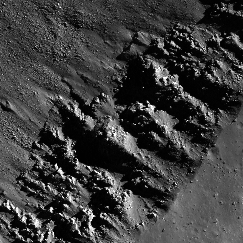
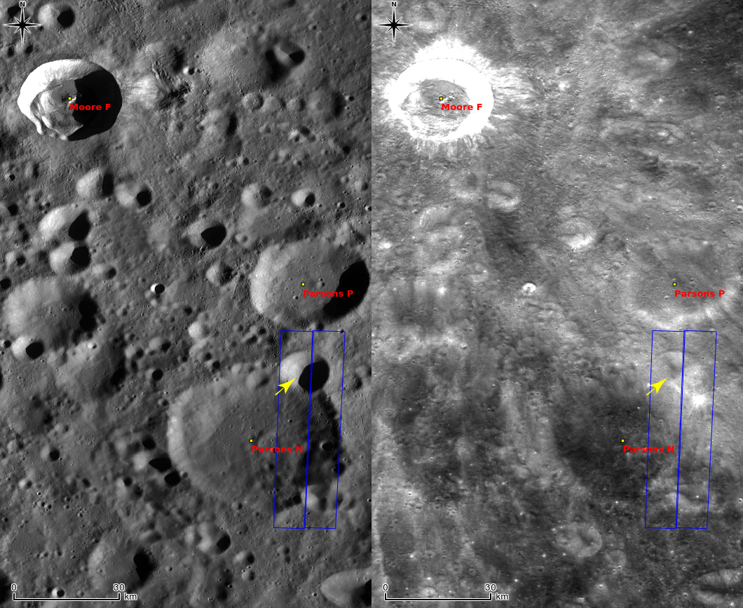
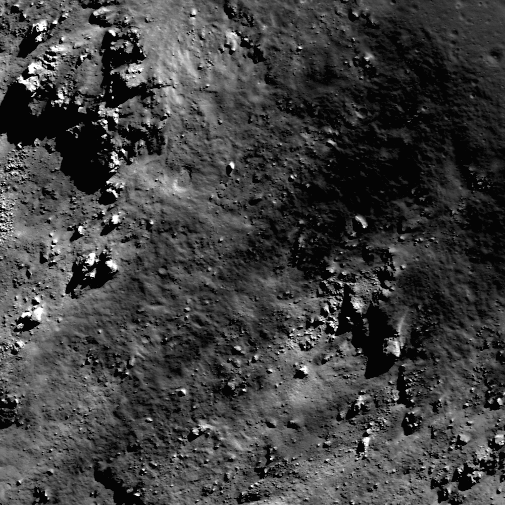
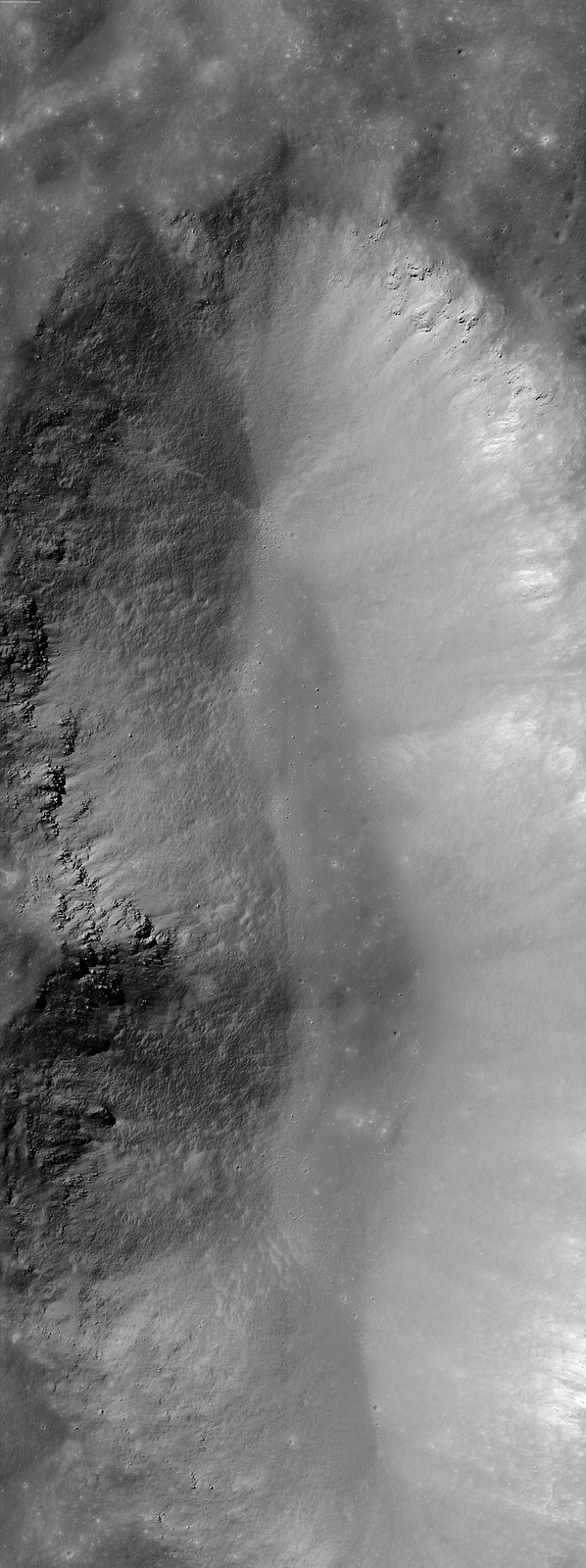
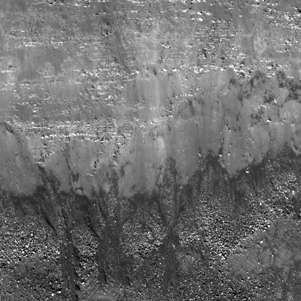
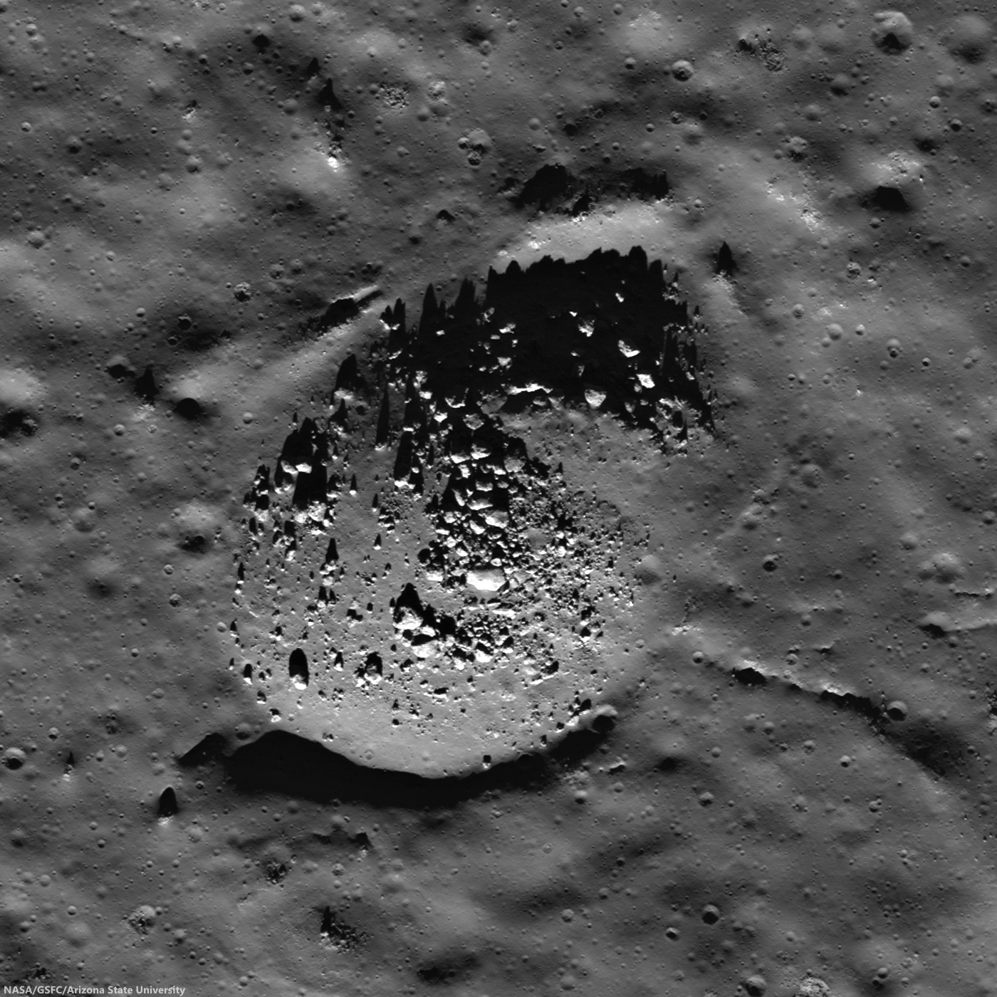
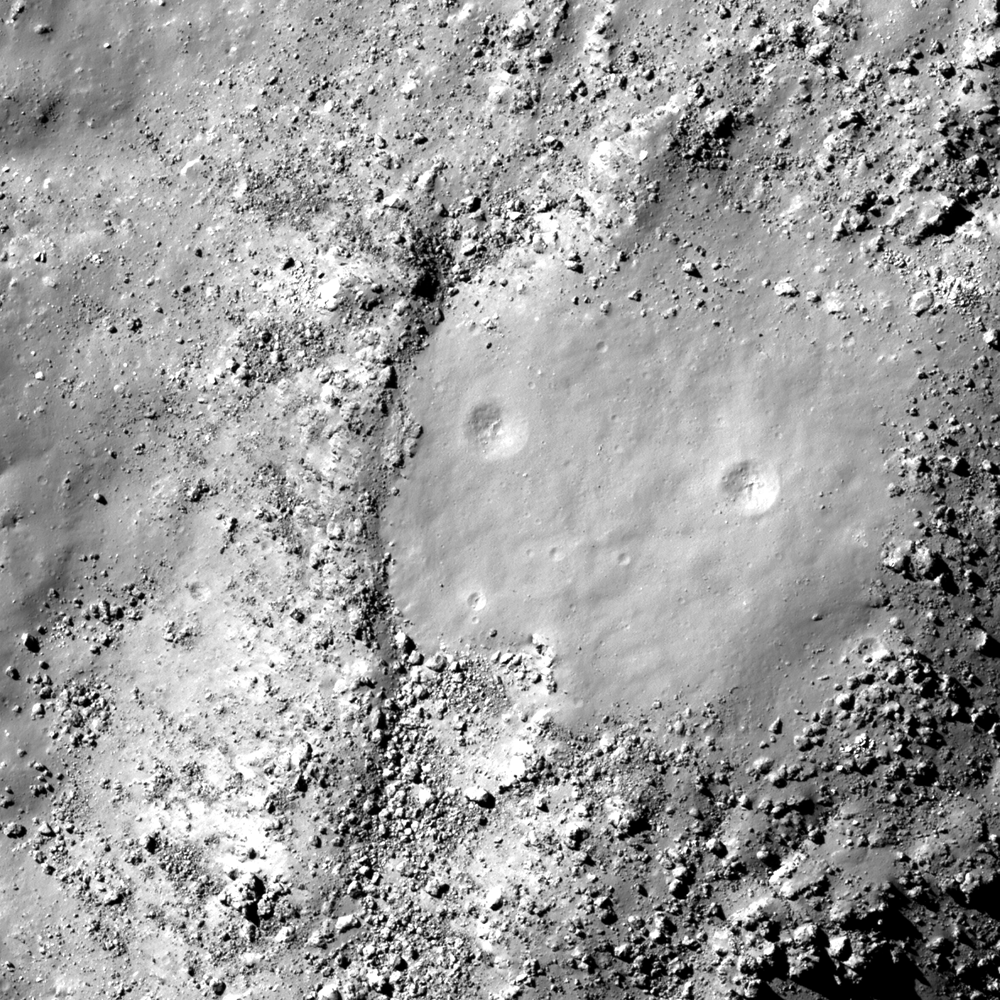
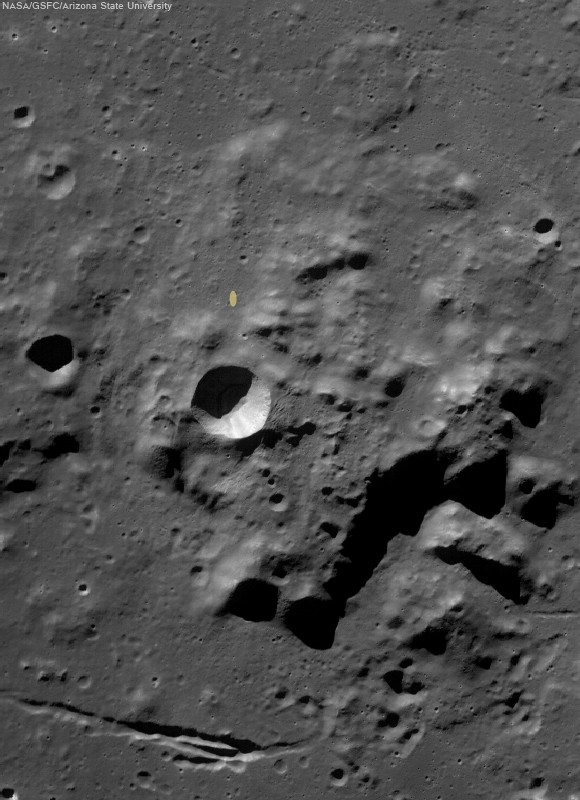
Hausen's mantel? House and city block-sized boulders steadily shed down the slopes of the central peak cluster of Farside Eratosthenian crater Hausen (163.24km; 65.111°S, 271.509°E), the formation of which might have finished off excavation of the Moon's deepest vertical column (an estimated 29 km below global mean elevation), finishing off a process begun by the progenitor of the South Pole-Aitken impact basin, billions of years earlier. Hausen straddles SPA's eastern rim, where Hausen later brought to the surface materials that should include samples of the Moon's mantle, an elusive primordial layer between crust and core. Among the places to look for confirmation is this central peak high place, seen here in a 3.7 km-wide field of view from LROC NAC mosaic M1132455869LR, orbit 19007, August 29, 2013; incidence 64.65° at 49 cm resolution from 42.46 km over 64.95°S, 271.99°E [NASA/GSFC/Arizona State University].
Paul Spudis
The Once and Future Moon
Smithsonian Air & Space

Geoscientists want to peer ever deeper into the interior of planets. Most rocky planets have a tripartite configuration, with a dense, metallic core at center, overlain by a rocky, iron-and magnesium-rich mantle, and finally, a low-density crust rich in silicon and aluminum on the outside. A surprise from the exploration of the Moon was that it too is configured like the Earth, with a core, mantle and crust, although of different proportions. All our samples from the Moon come only from the crust, so understanding the composition and nature of its mantle has been a high priority for lunar scientists.

With the Moon, we are fortunate to have some natural “drill holes” with which to probe the subsurface. I refer of course to the multitude of large craters on the Moon, including those largest of impact features, the multi-ring basins. Basins are impact structures hundreds of kilometers across; the largest basin, South Pole-Aitken, is over 2500 km in diameter. Because basins are so large, they dig down many kilometers below the lunar surface. If we can identify material of deep derivation that has been thrown out during basin formation, we can characterize the lower crust and possibly, the upper mantle of the Moon.

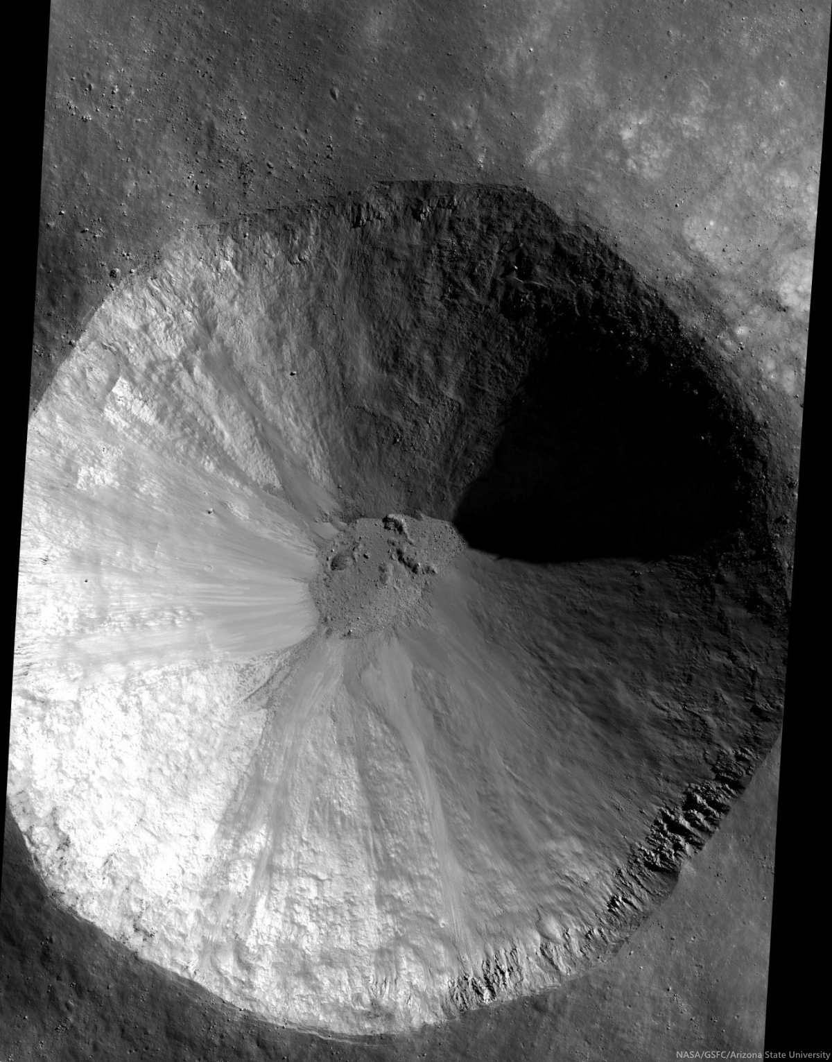
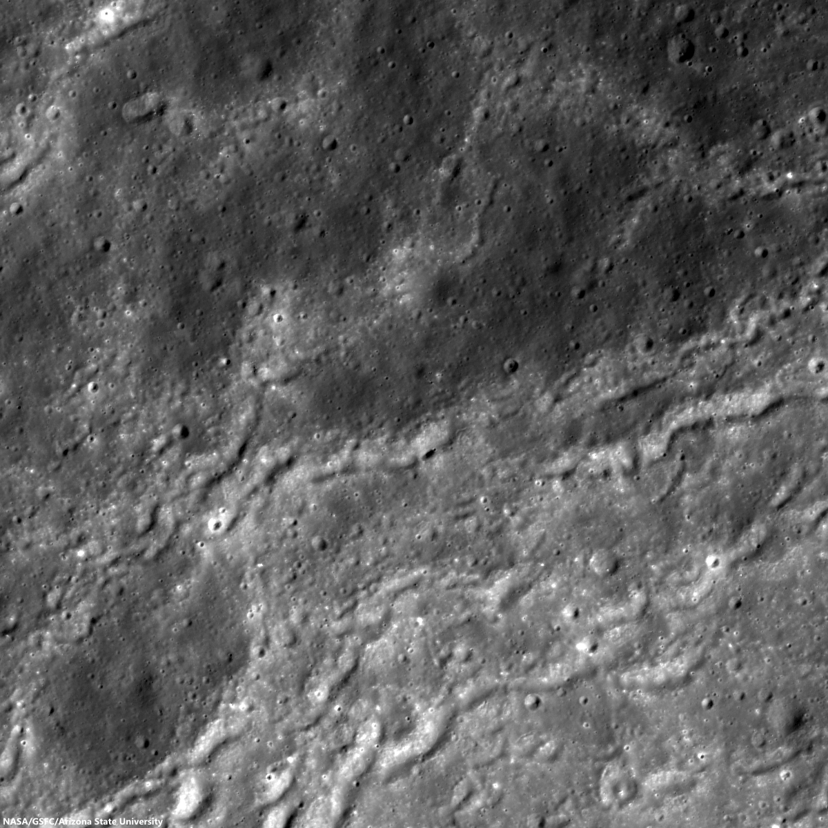
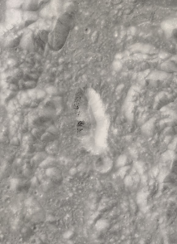
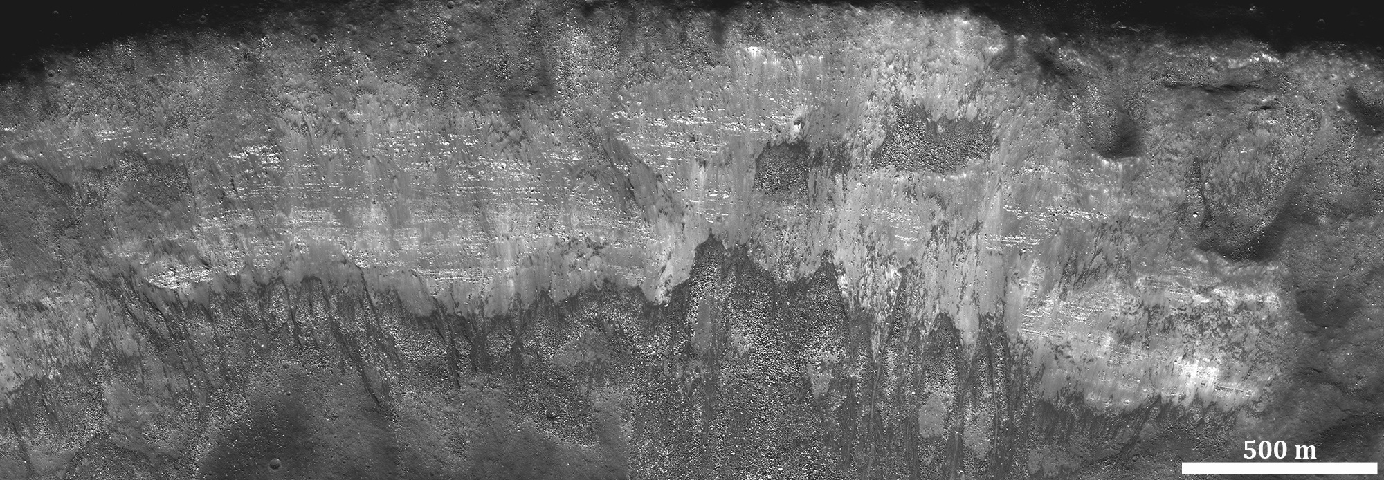
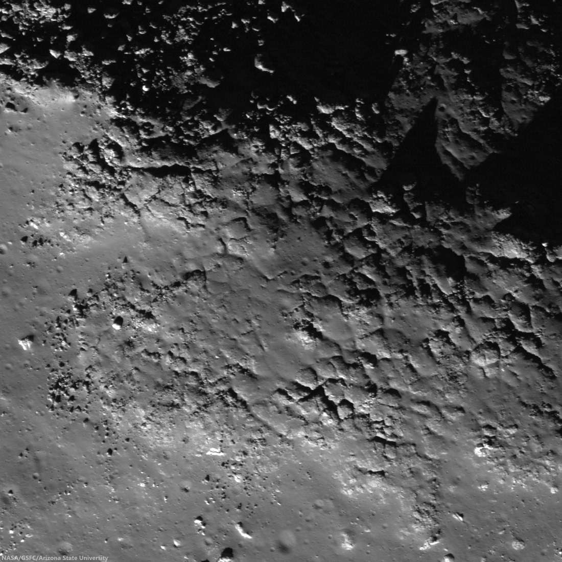
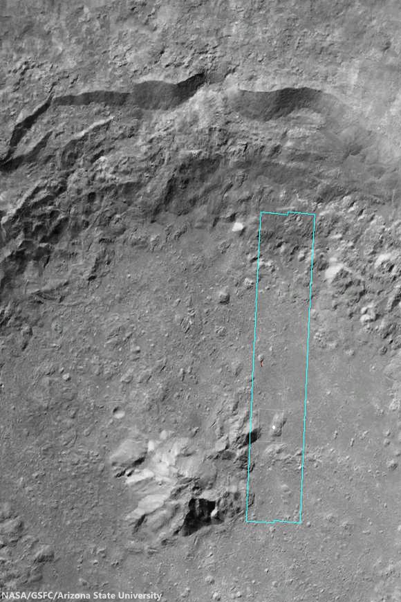
Copernican age excavation of Schrödinger peak ring. An unnamed 7.1 km Copernican age crater  (72.13°S, 133.78°E) and excavation of the prominent Peak Rings of Schrödinger impact basin, the Moon's youngest, and itself an excavation inside much larger South Pole-Aiken impact basin, the Moon's oldest. The young crater features outcrops inside its rim that are within the 10 km "walk-back" distance from a proposed landing site. LROC NAC mosaic M126057860LR, LRO orbit 3710, April 16, 2010; 74.66° angle of incidence, 1.05 meters per pixel resolution from an altitude of 50.71 km [NASA/GSFC/Arizona State University].
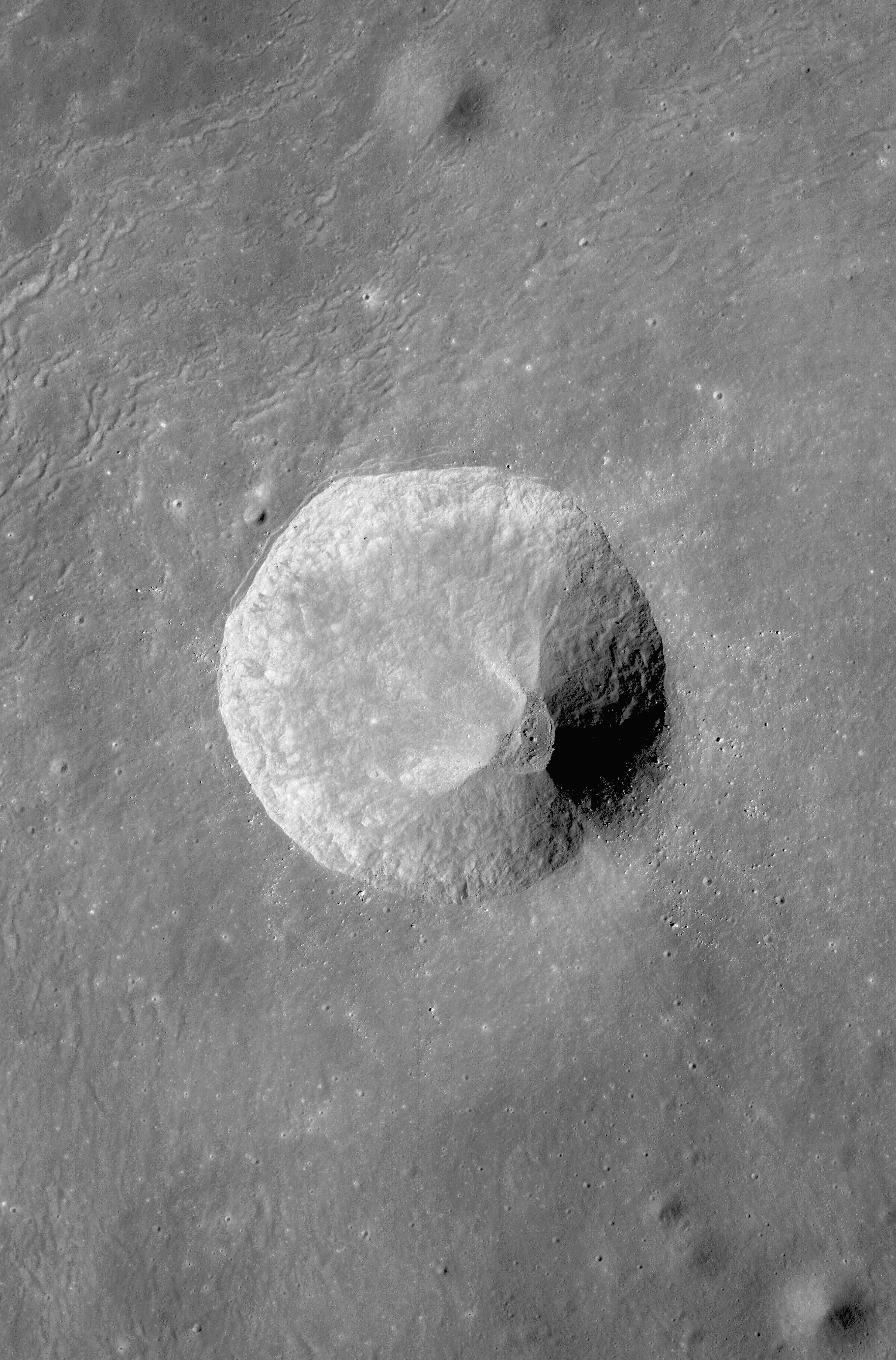
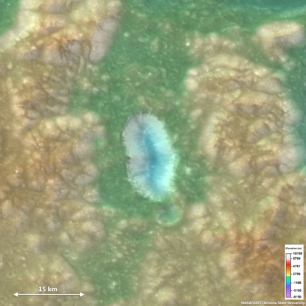
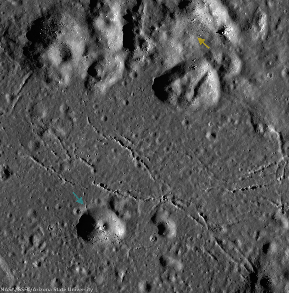
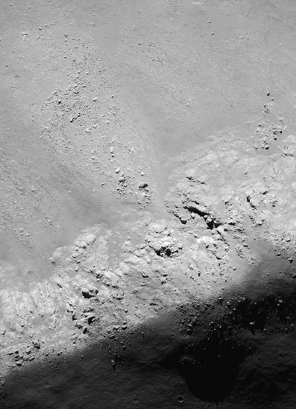
The proposed landing site (yellow ellipse), north and downslope, within 10 km "walk-back" distance from the Copernican age crater on top of the inner Schrödinger peak ring. Even at 80 meters resolution, outcrops of interest, along with other youthful anatomy in the 7.1 km crater are visible. LROC WAC observation M169698283CE (604 nm wavelength), LRO orbit 10142, September 3, 2011; incidence 72.7° [NASA/GSFC/Arizona State University]. 
Needless to say, an effort like this is fraught with difficulty. Basins are large features (at 930 km in diameter, the lunar Orientale basin is as big as the state of Texas) and we don’t fully understand the mechanics of their formation, including such rudimentary properties as their original size (it is suspected that the final diameters of these features were enlarged by collapse, making their original size uncertain). However, that doesn't stop us from trying. Using basins as probes of the crust and mantle has been a pastime for lunar scientists for many years.

At this year’s Lunar and Planetary Science Conference (LPSC 45), the topic of the mantle was raised once again, but this time with a bit of a twist.

Decades ago, a network of seismometers was emplaced on the Moon during the Apollo missions. This network measured the intensity and duration of “moonquakes” over the course of several years. These measurements allowed us to discover the mantle of the Moon and to estimate its density. The density is proportional to the velocity of seismic waves, which can be measured from the difference in arrival times of seismic waves at different stations for the same moonquake. From these data, we know that the mantle is composed of rock quite different in composition from surface rocks. The inferred relative density of the mantle is considerably higher – about 3.2 g/cm3 (grams per cubic centimeter; water = 1.0) than the crustal rock types (about 2.6 g/cm3). Although a single piece of information, this density constrains the mantle of the Moon to be composed of only one or two possible minerals – olivine and/or pyroxene (only these iron and magnesium-rich minerals are common enough and match the density estimate). We also suspect such mineralogy because the Earth’s mantle is made up of these minerals.

For many years, lunar scientists have searched diligently for deposits of olivine around lunar basins, material that could plausibly be interpreted as ejected from the lunar mantle. Yet to date, few such deposits have been found, and those that are seen, could just as easily derived from crustal rocks, as olivine is a common mineral in the crust as well.

Crustal Thickness from GRAIL (2012) -Lunar Crust with Olivine signatures superposed over LROC WAC-DTM. Though the Moon's unexpectedly thin crust has been mapped in great detail, and constraints put on the density of lunar mantle, detection of olivine, one likely component of the crust, on the surface can't yet be definitively said to be of deep lunar origin. Full-size image HERE [NASA/JPL/MIT].
The recent gravity mapping of the GRAIL mission has added confusion on this score. Assuming reasonable densities for crust and mantle, gravity maps can be interpreted in terms of crustal thickness at any given area. The new GRAIL crustal thickness maps indicate a much thinner crust than previous estimates had shown, with a mean thickness of about 35 km, increasing to almost 45 km in some areas of thick crust.  These values are about half the previous numbers and suggest that the largest impact events should have easily excavated the upper parts of the lunar mantle. The problem is that there doesn't appear to be any mantle material on the lunar surface, even proximate to the biggest basins. This absence is quite puzzling; despite the ubiquity of olivine in many lunar rocks, we do not find vast exposures of it near the rims of any lunar basin.

At the recent LPSC 45, H.J. Melosh of Purdue University and his fellow co-workers suggested that we are looking for the wrong mineral. If the upper mantle were composed not of olivine, but a different mineral, large amounts of olivine would not necessarily be excavated by a basin-forming impact. Their calculus is as follows: the crust is thin (from GRAIL maps), computer models show that Orientale basin must have excavated the lunar mantle (from calculation), and we see pyroxene in mineral spectra of basin deposits but not olivine (from remote sensing data). Therefore, the mantle is made up of pyroxene, not olivine.

One might note that this chain of reasoning is a house of cards. IF the GRAIL measurements are telling us how thick the crust is and IF the computer models accurately reproduce basin-forming mechanics and IF the compositional data are correct, then a pyroxene mantle is required. In fact, of these ‘constraints,” only the compositional data are fact-based. GRAIL did not measure crustal thickness – it measured gravitational accelerations, objective measurements interpreted in terms of crustal thickness. Computer models attempt to simulate reality, but there is no way to directly test their validity. The scale of basin impact is so large – orders of magnitude beyond any impact event within our experience base – that unsuspected physical effects (possibly of critical importance) cannot be accounted for.

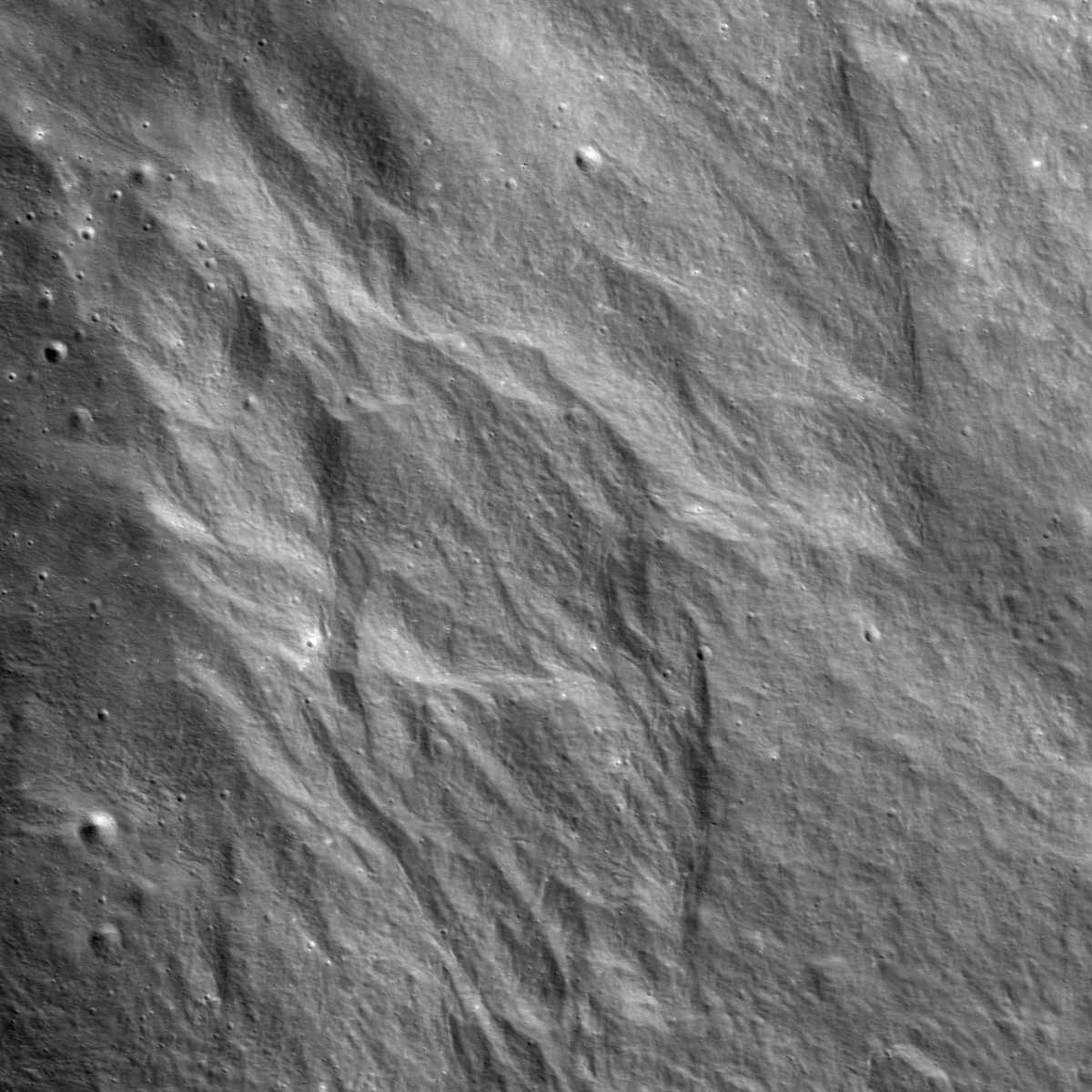
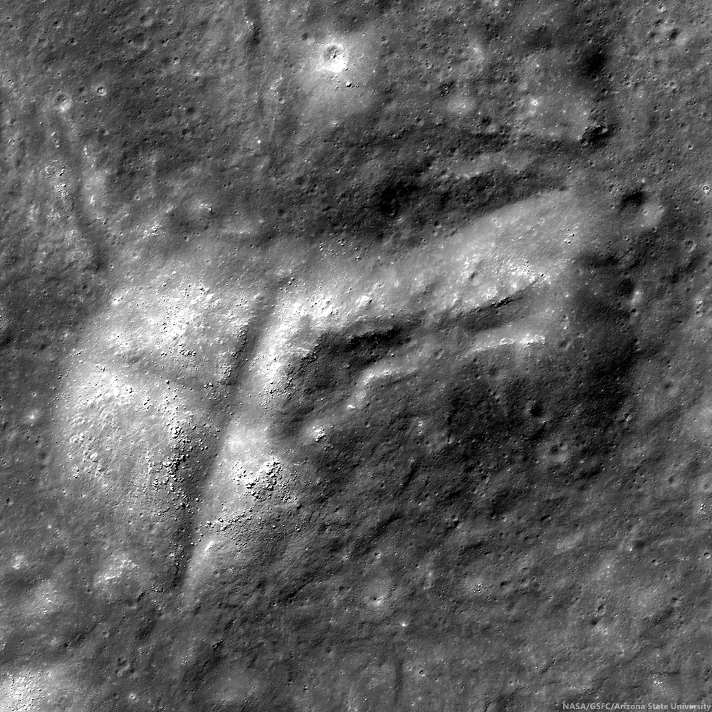
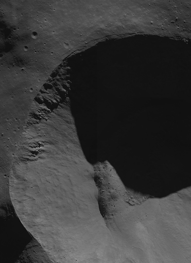
Though there is wide evidence that the energetic Orientale impact basin-forming event had far-reaching effects, possibly causing volcanic upwelling in widely scattered areas and the creation of strong surface magnetic fields on the direct opposite side of the Moon, it's now thought possible that the basin's progenitor might not have exposed the Moon's mantle [NASA/GSFC/Arizona State University].
An alternative explanation is that as large as they are, basins do not come close to digging into the Moon deeply enough to excavate the mantle. At the same session, I presented the results of new research on the composition of ejecta from the Orientale basin, which show its deposits to be low in iron and probably derived only from upper crustal levels. This is quite surprising; the Orientale basin is one of the youngest basins on the Moon and at nearly 1000 km diameter, also one of the biggest. Virtually all of its ejecta come not only from crustal sources (as measured by remote sensing data) but also from upper crustal materials, suggesting that even the biggest impacts apparently cannot punch through the crust of the Moon.

Dr. Paul D. Spudis is a senior staff scientist at the Lunar and Planetary Institute in Houston. This column was originally published by Smithsonian Air & Space online, and his website can be found at www.spudislunarresources.com. The opinions he expressed here are his own, but these are better informed than most.

Thursday, April 3, 2014

A Small Clearing on the hazardous floor of Tycho

Mound littered with boulders on the floor of Tycho features a rare clearing, in the midst of the general rubble, of relatively low slope. The mound, east of the landmark nearside crater's spectacular central peaks, likely formed from squeezed up impact melt. LROC NAC observation M1144856403R, LRO orbit 20751, January 20, 2014, field of view 730 meters wide; illumination incidence angle 57.92° at 72 cm per pixel resolution from 59.2 km [NASA/GSFC/Arizona State University].
Raquel Nuno
LROC News System

Tycho is one of the most spectacular craters on the Moon. If you've never done so, next time you get access to a pair of binoculars and the Moon is near full, look at the Moon's southern hemisphere: you will see a very bright crater with spectacular rays emanating from it. That's Tycho!

It formed when an asteroid (or comet), going at roughly 20 km/s, hurled into the Moon around 109 million years ago. That age may seem old to you and me, but by lunar standards, that's young.

We think we sampled impact melt that originated from Tycho at the Apollo 17 landing site, but we can also tell it's young just by looking at it: it has a crisp morphology and its rays are seen as high reflectance streaks. With time, exposure to the space environment will fade the rays and erode the crater's sharp features into smooth curves.

Small mound with clearing, east of the more spectacular central peaks of Tycho, in the context of a wider cropped, 3 km-wide field of view from LROC NAC observation M1144856403R {NSA/GSFC/Arizona State University].
During an impact event, almost all of an impactor's kinetic energy gets deposited as internal energy into the target rock. The near-surface layers of the shock melted rock begin cooling relatively quickly, creating a hardened crust lining the crater floor. The subsurface melt, however, can take up to ~500,000 years to cool. This post-impact thermal structure sculpts the floor of many lunar impact craters.

LROC Wide Angle Camera (WAC) mosaic, context for the footprint of LROC NAC observation M1144856403L & R (blue rectangle), showing the 3 km crop and location of the clearing. LROC WAC monochrome (643 nm) mosaic of seven sequential passes over the region, February 21, 2011; rough incidence angle 57.78° at 63.4 meters resolution from 46.25 km; field of view roughly 36.8 km across [NASA/GSFC/Arizona State University].
Today's Featured Image is a ledge of a mound on the floor of Tycho crater. The mound is littered with meter-sized boulders, except for this smooth portion on this western ledge. Why is this portion so smooth? The two apparently identical looking 44 meter craters that dot the smooth region probably did not have enough energy to push the boulders aside, and they most likely did not excavate enough material to cover the boulders. The answer may be that still molten rock extruded from beneath the cooled crust, oozing onto the surface, leaving the boulders just out of sight.

Tycho (85.29 km, 43.295°S, 348.784°E) in a roughly 117 km-wide field of view from seven sequential LROC WAC monochrome (643 nm) observations from over the region on February 21, 2011; incidence angle 57.8°, about 63.4 meters resolution from 46.25 km [NASA/GSFC/Arizona State University].
Can you find other examples of effusive events and melt squeeze ups in the full resolution NAC? Hint: look along the floor fractures, HERE.

Related Posts:
Fractured melt rock on Jackson's terraced wall (October 22, 2013)
Melted Moon (July 31, 2013)
Landing Site at Tycho North (Science Concept 7) (March 20, 2013)
Rippled Pond on Tycho's Wall (September 13, 2012)
Breached Levee at Tycho (September 11, 2012)
America's last unmanned lunar lander (September 7, 2012)
Giant Flow of Impact Melt (August 14, 2012)
River of Rock (June 20, 2012)
View from the Other Side (May 21, 2012)
Impact Melt Fingers (May 8, 2012)
Melt on a Rim (May 3, 2012)
Jackson's Complexity (January 20, 2012)
Tycho's flash-frozen inferno (November 2, 2011)
Ejecta on slumped wall of Tycho (December 9, 2010)

When the Moon is full, Tycho's bright ray system is among the few lunar features visible to the naked eye. A testimony to its youth, a low degree of steady space weathering when compared to hundreds of similar but older crater,s from before the time when dinosaurs ruled the earth. The "miracle boys of Minsk" (Astronominsk) captured this local late morning image of Tycho, part of a full disk monochrome mosaic, captured from Belarus, September 20, 2010.  One of their fabulous color images of Тихо can be viewed HERE Above originally posted to illustrate "Landing Site at Tycho North (Science Concept 7), March 20, 2013 [Astronominsk].