Wednesday, August 31, 2011

LROC: Stratigraphic layers exposed by Hadley Rille


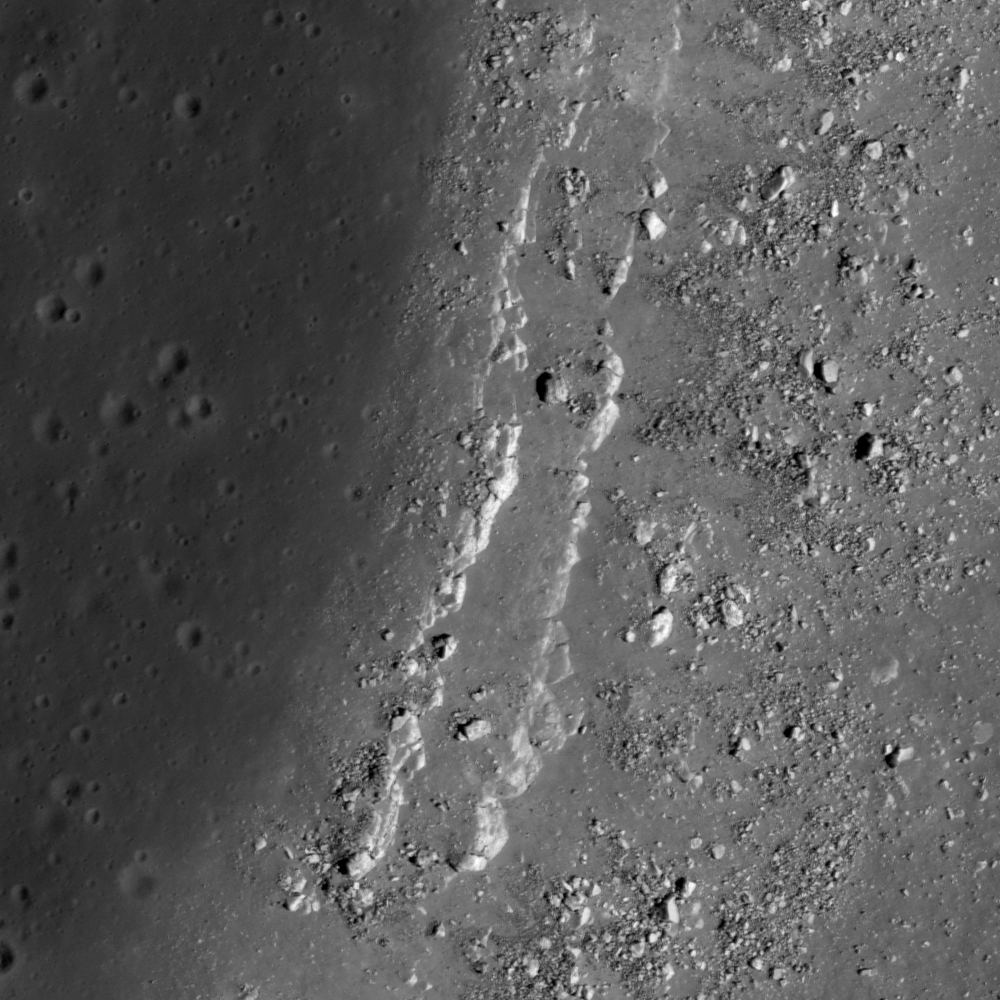
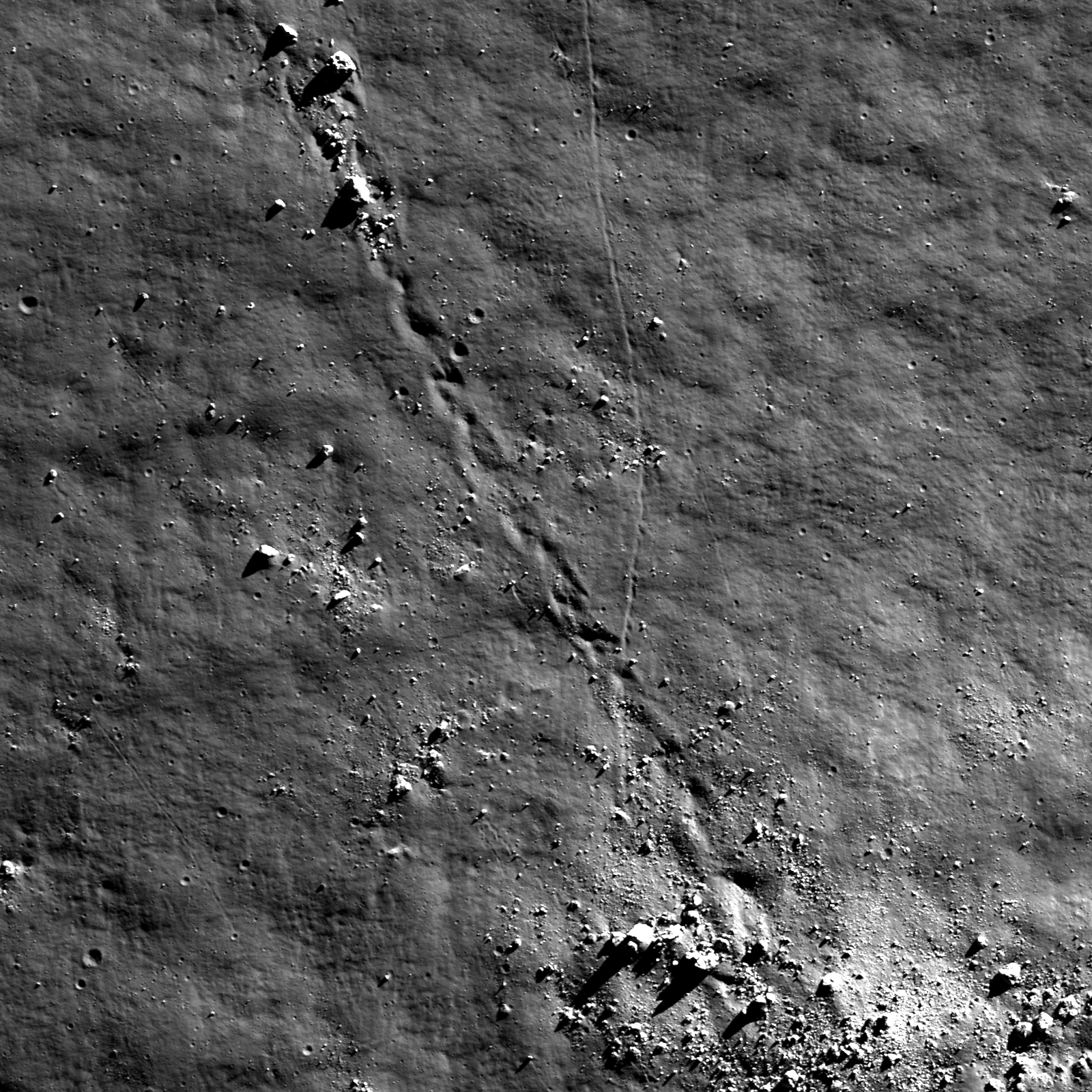
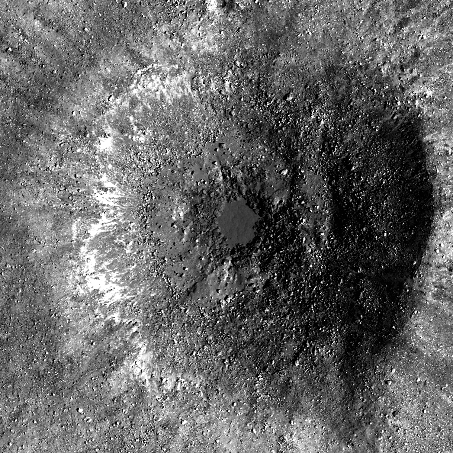
West side edges of Hadley Rille, 45 kilometers southwest of the 1971 Apollo 15 landing zone. LROC Narrow Angle Camera observation M113941548L, LRO orbit 1925, November 27, 2009; resolution is 50 cm/pixel, field of view 500 meters with a solar illumination incidence angle 59° from the southeast. View the full size LROC Featured Image HERE [NASA/GSFC/Arizona State University].

Hiroyuki Sato
LROC News System

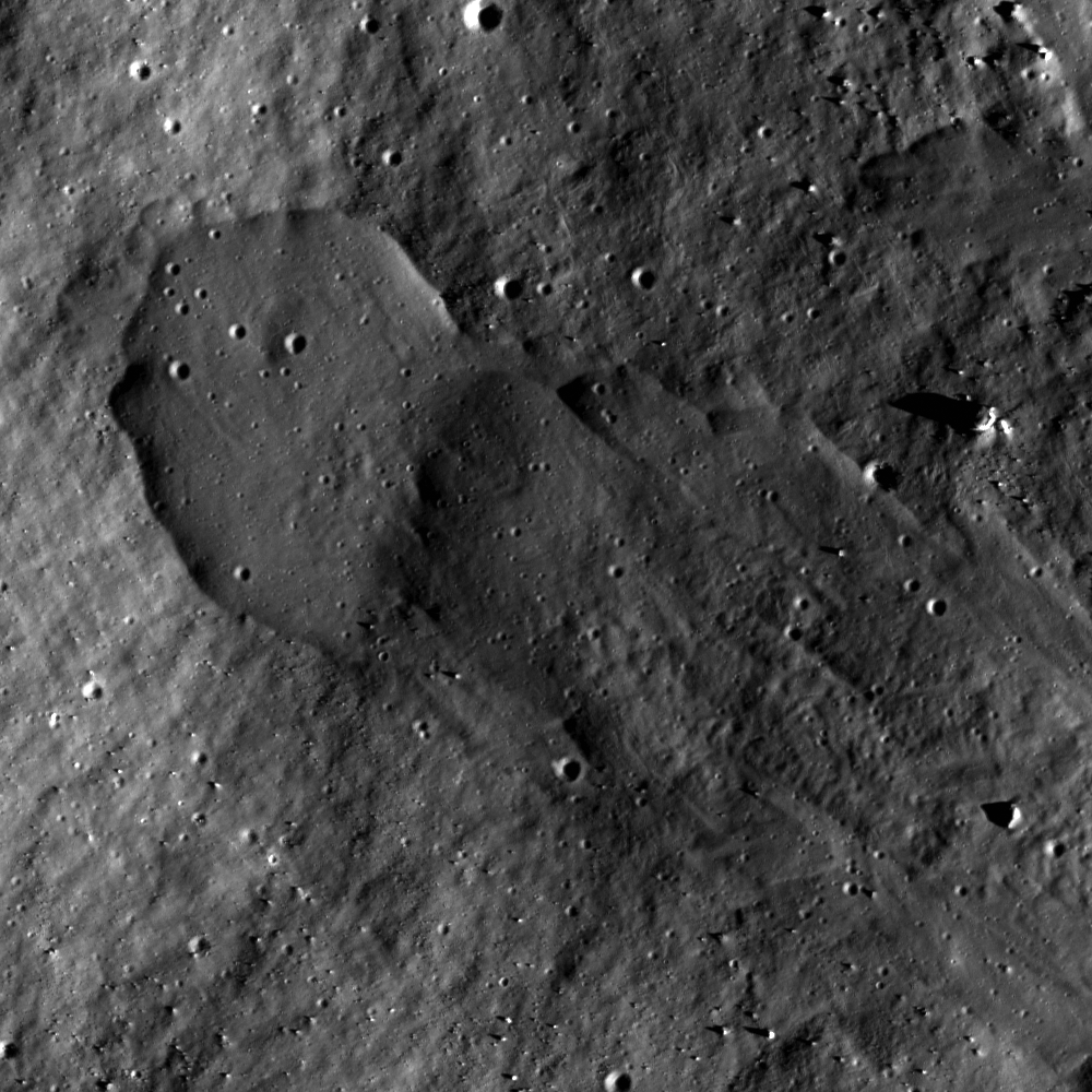
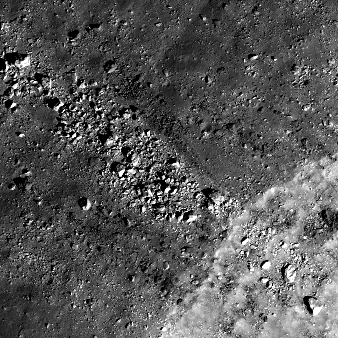
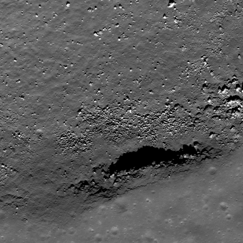
Today's Featured Image are bedrock outcrops at the western edge of Hadley Rille, in an area located about 50 km southwest from the Apollo 15 landing site. Two parallel lines of high-reflectance rocks extend in a north-south direction on the western rim of the Rille. The right side of the image is the downward slope of the rille, where you can see multiple boulders that have likely fallen from the outcrops in the center in the billions of years since the great rille was carved into the mare by flowing lava.


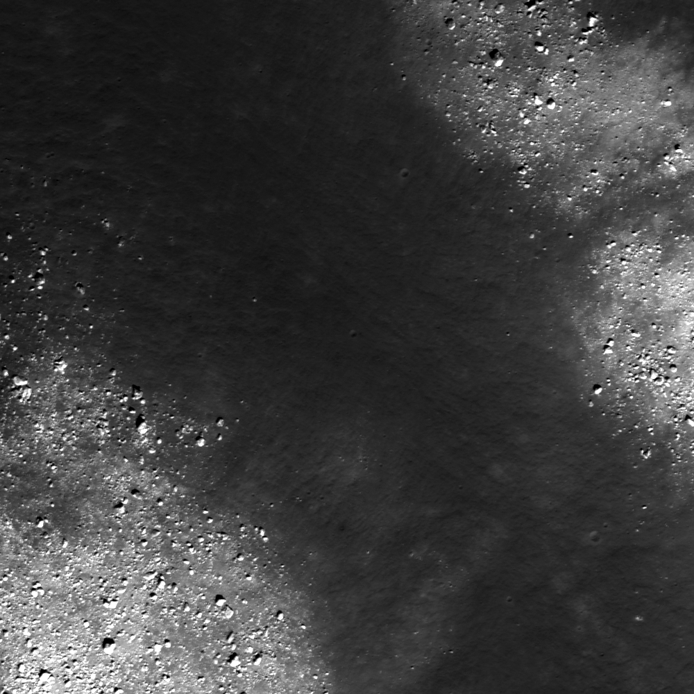
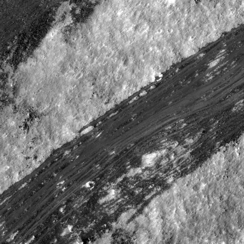
For context, the layers of extrusive volcanism that formed the surface of Palus Putredinis and the Hadley Rille Delta and later exposed in the formation of Hadley Rille are seen in the full width 300 by 4oo meter crop from NAC frame M113941548L [NASA/GSFC/Arizona State University].

These two layer outcrops can be almost continuously observed along the flank of Hadley Rille for about 2.5 km length, which suggesting that these layers have relatively wide area coverage and an almost uniform thickness.


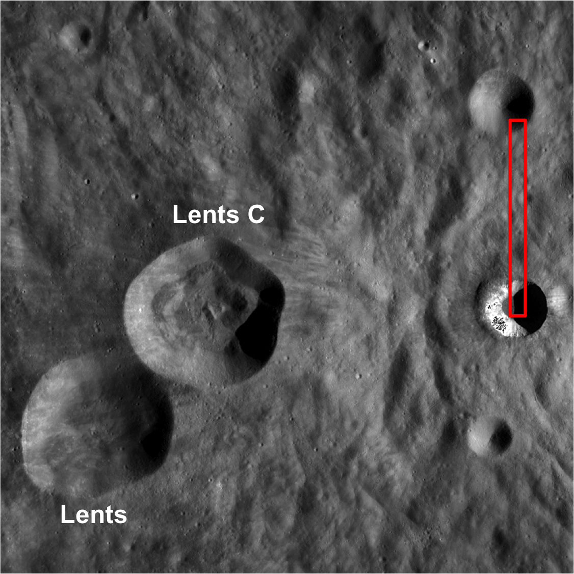
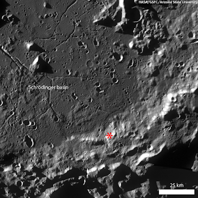
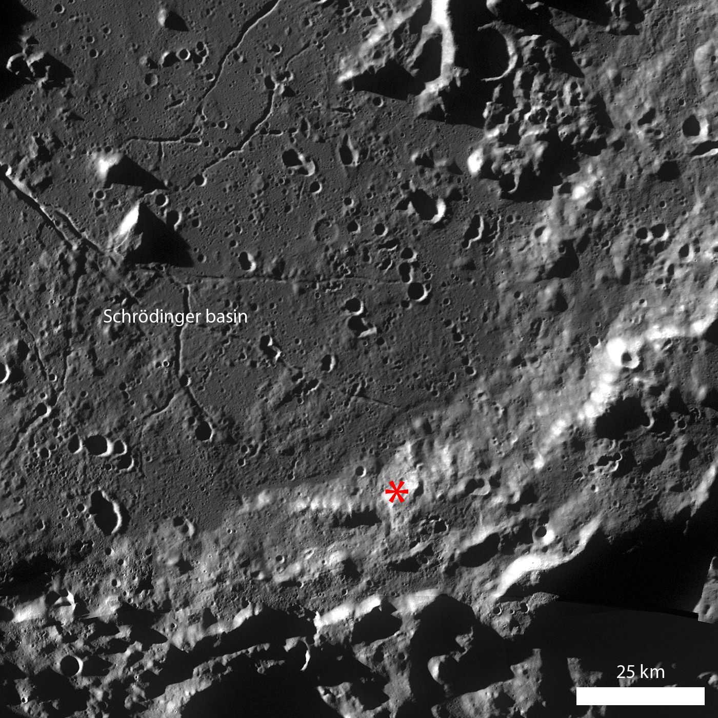
A late afternoon LROC Wide Angle Camera (WAC) 604 nm band mosaic shows the Hadley Rille Delta and Palus Putredinis between the Apollo 15 landing zone (red square) and the strategraphic area of interest 45.3 km to the southwest pinpointed in the LROC Featured Image released August 30, 2011. LROC WAC mosaic stitched from observations made during LRO orbits 7313-7315, January 24, 2011 [NASA/GSFC/Arizona State University].

Detailed topographic assessments using the Lunar Orbital Laser Altimeter Digital Terrain Model or possibly even NAC stereophotogrammetry will enable lunar scientists to obtain accurate thickness measurements for these two rock layers, as well as derive estimates for the thickness of the overlaying regolith layer in this area. This information will be very useful to lunar scientists who are currently trying to understand the geologic processes involved with mare volcanism. If we assume that these layers correspond to mare basalt flows, then determining the thickness and the spacial extent of these flows will be important information for calculating the viscosity and eruption volume of lava at one event. Research efforts like this one are helping lunar scientists define key questions that will be answered by future human lunar exploration!


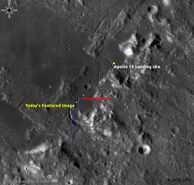
LROC WAC monochrome mosaic 100 m/pixel around Hadley Rille. Image center is latitude 25.52°, longitude 3.11°. Blue box and white star indicate the locations of NAC frame and LROC Featured Image, August 30, 2011. View the larger version HERE [NASA/GSFC/Arizona State University].

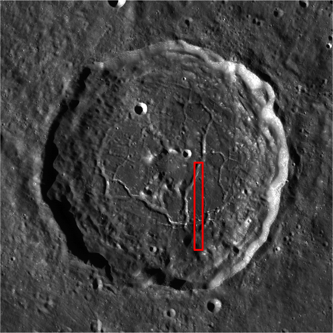
Explore the parallel bedrock outcrops at Hadley Rille in the full NAC frame!

Related posts:
Layering in Euler Crater
Dark surface materials surrounding Rima Marius
Lava Flows Exposed in Bessel Crater
Dark streaks in Diophantus crater
Linné Crater

Monday, August 29, 2011

Jeux lunaires


French artist Laurent Laveder has shared a couple dozen beautiful images of the moon used as a prop. His other night- and sky-themed works include 3D starscapes, which can be found in his PixHeaven gallery.
HT: Neatorama / Jeux lunaires

Saturday, August 27, 2011

LROC: Atlas


The interior of a crater-floor fracture within landmark nearside crater Atlas. LROC Narrow Angle Camera (NAC) observation M157303976L, LRO orbit 8316, April 13, 2011; incidence angle 47°, resolution 0.5 meters per pixel. View the full size LROC Featured Image HERE [NASA/GSFC/Arizona State University].

Sarah Braden
LROC News System

Floor-fractured Atlas crater (46.7°N, 44.4°E) is 87 km in diameter. The cause of the fractures that cut the crater's floor is not well understood. It is thought that the fractures have wide, flat floors, like a trough (or graben) and that they record a period of uplift of the crater floor. The question is, what caused the uplift? Floor-fractured craters have been a known lunar feature since the days of the Lunar Orbiters, but with LROC images, geologists are working to better understand how they formed. LROC NAC frames allow for a look at the interiors of the fractures, and with stereo images we can measure their shapes.


A roughly 2 by 4 kilometer section of LROC NAC frame M157303976L, from which the field of view (red box) within the LROC Featured Image released August 26, 2011 can be found [NASA/GSFC/Arizona State University].


And, in turn, the field of view within the image above is seen in this small section of a much larger LROC Wide Angle Camera (WAC) 643 nm band mosaic gathered during LRO orbits 2750 through 2757, January 31, 2010. The field of view is roughly 50 x 100 kilometers [NASA/GSFC/Arizona State University].

After the impact that created Atlas, the floor of the crater was molten. As it cooled, the solid floor formed. In the case of Atlas, eventually uplift caused the floor to break and pull apart, forming the graben, or fractures. There are two theories for the cause of the uplift. One possibility is the slow readjustment of the crust after the crater-forming impact. During an impact, the energy released compresses the crust. However, over time the crust can rebound to its original, pre-impact position. This rebound would supply the uplift that forms the fractures on the floor of Atlas crater. A second possibility is that the fractures may be due to an intrusion of magma into the crust below the crater, which uplifted and disrupted the crater floor as it rose. When investigating floor-fractured craters, geologists often look for signs of volcanic activity related to an intrusion of magma. Unraveling the origin of lunar features like this one is a primary focus of LROC science.


One hundred meter per pixel WAC context view of Atlas, showing the field of view of the entire LROC NAC frame M157303976L View the full size LROC WAC context image HERE[NASA/GSFC/Arizona State University].

Explore the entire NAC frame!

Related Images:
Mapping the Moon with Wide Angle Camera
The fractured floor of Compton
Gassendi's Fractures
Alphonsus crater mantled floor fracture


From an Earth-bound perspective Atlas (upper right) is the constant companion of it's neighbor to its west, 71 km-wide Hercules, seen in this oblique view captured when the Moon was Full, January 10, 2009, by Mario Weigand [LPOD/SkyTrip.de/VMA].

Friday, August 26, 2011

Outside Giordano Bruno


Impact melt outside Giordano Bruno. LROC Narrow Angle Camera (NAC) observation M161646501R, LRO orbit 8956, June 2, 2011; illumination from the southwest, incidence angle 71° and resolution 55 centimeters per pixel. View the full-size LROC Featured Image HERE [NASA/GSFC/Arizona State University].

Sarah Braden
LROC News System

Giordano Bruno (35.9°N, 102.8°E) is a Copernican-age impact crater known for interesting impact melt features. The crater is named after the famous Italian philosopher Giordano Bruno who lived during the Renaissance.

Today's Featured Image shows an impact melt flow outside of the crater walls. This impact melt was thrown from Giordano Bruno and landed about 6 km away from the rim. Some of the material was hot enough that it continued to flow after being emplaced on the surface. The direction of flow is toward the top of the frame, away from the rim of Giordano Bruno. Although formed by a different process, impact melts flow in much the same way as lava flows, forming lobes and exhibiting channels and levees. Like lava flows, they cease to move when their source is depleted or the melt cools and freezes into solid rock.


Bright, relatively young Giordano Bruno impact melt, visible in LROC NAC frame M161646501R, in context of a crop from a 76 meter/pixel resolution, 604nm mosaic of four LROC Wide Angle Camera (WAC) observations swept up in orbits 3044-3047, February 23, 2011. See a wider field of view HERE [NASA/GSFC/Arizona State University].

Giordano Bruno is one of the youngest large craters (22 km diameter) on the Moon. How old is "youngest"? Most of the time, geologists classify the youngest craters into a group called Copernican-aged craters. However, if humans went back to the Moon they could sample some of the impact melt outside of Giordano Bruno, bring the sample back to Earth, and then use radiometric age dating to estimate the age of the rock. Impact melt rocks can be used to measure the age of an impact since the rock's "isotopic clock" is reset when it returns to a molten state.


One hundred meter per pixel LROC WAC context image of Giordano Bruno. The red box shows the extent of LROC NAC frame M161646501R. The impact melt outside of Giordano Bruno is in the lower end of the frame. See the full-size context image HERE [NASA/GSFC/Arizona State University].


Full width view of NAC frame M161646501R. The LROC Feature Image released August 25, 2011 focuses in on the lobe of flash-frozen impact melt from Giordano Bruno above left [NASA/GSFC/Arizona State University].

Explore the entire NAC frame for more impact melt flows outside of Giordano Bruno!

Related Images:
King crater ejecta deposits
LROC: Mare Undarum "Action Shot"
Fragmented Impact Melt
Impact Melt Flows on Giordano Bruno
Delicate Patterns in Giordano Bruno ejecta
Young Giordano Bruno


Giordano Bruno captured by the Planetary Camera onboard Japan's Kaguya (SELENE-1) lunar orbiter in 2007 [JAXA/SELENE].

GRAIL set for early September lift-off

Using a precision formation-flying technique, beginning in January 2012, the twin GRAIL spacecraft will map the moon's gravity field.

The twin GRAIL lunar probes are set to launch aboard a United Launch Alliance (ULA) Delta II, from Cape Canaveral Air Force Station (CCAFS), September 8. That date offers two instantaneous launch windows, at 12:37:06 and and 13:16:12 UT, beginning an optimal launch period (last for a Delta II at the Cape) extending through October 19 when launch windows open approximately four minutes earlier each consecutive day.

The twin GRAIL, developed at JPL originally as a "precursor mission" in support of goals for the defunct Constellation program, are designed to more precisely determine the Moon's interior composition, "from crust to core," and to advance understanding of the Moon's thermal evolution.

A prelaunch news conference is scheduled at the Kennedy Space Center's Press Site, Tuesday, September 6, at 1700 UT. Scheduled to participate in the briefing are Ed Weiler, Science Mission Directorate, NASA HQ; Tim Dunn, KSC launch director; Vernon Thorp, NASA Missions program manager, United Launch Alliance; David Lehman, GRAIL project manager, Jet Propulsion Laboratory (JPL) in Pasadena; John Henk, GRAIL program manager for Lockheed Martin and Joel Tumbiolo, launch weather officer, 45th Weather Squadron, CCAFS

A GRAIL mission science briefing at the KSC Press Site is scheduled Wednesday, September 7, at 1400 UT, Participating in that briefing are Robert Fogel, GRAIL program scientist, NASA Washington; Maria Zuber, GRAIL principal investigator, Massachusetts Institute of Technology; Sami Asmar, GRAIL deputy project scientist, JPL and Sally Ride, president and CEO of Sally Ride Science of San Diego


Thursday, August 25, 2011

LROC: Dichotomy


Dark material on the wall of a Copernican crater northwest of Mare Orientale. The center of the crater is to the lower left. LROC Narrow Angle Camera (NAC) observation M135847041R, LRO orbit 5153, August 7, 2010; incidence angle 53°, scale 0.53 meters/pixel. View the full-size LROC Featured Image HERE [NASA/GSFC/Arizona State University].

Sarah Braden
LROC News System

The wall of this 8.5 km diameter, Copernican-aged crater (located at 3.29°N, 100.25°W) is streaked with dark material. When geologists describe different surfaces on the Moon or other planetary objects, we use the terms "high reflectance" and "low reflectance." In this case, the wall of the crater is high reflectance, but some of the material that has flowed down the wall is low reflectance.

What is the cause of the low reflectance of this material? How is it different from the high reflectance crater wall? Are the differences caused by composition, grain size, or both? Also, is this flow a granular flow, or an impact melt flow? Sometimes these two types of flow can behave similarly.


Simulated 3-D oblique view across the NAC observation draped over the lunar digital elevation model available using Google Earth. View a larger version of the image HERE [NASA/GSFC/Arizona State University].

Some quick observations can point us in the right direction. First, the crater is located on the far side of the Moon, in an area of highlands. This location most likely means that we are not observing a compositional difference, as there are no nearby sources of mare basalt that could account for the low-reflectance material. Second, in this particular NAC frame there is no evidence for impact melt deposits around the rim of the crater, although you can find evidence of impact melt in the crater floor. The crater is not large enough to develop terraces where impact melt can pool and then flow out. So this flow is probably granular, not molten.


100 m/pixel LROC Wide Angle Camera (WAC) context image of the Copernican crater surrounding area, in the farside lunar highlands. The red box outlines the area of the featured NAC frame. Note the Copernican crater has more boulders, crisper edges, and is brighter (less "optically mature") than the other craters, View the full-sized LROC WAC mosaic context image HERE [NASA/GSFC/Arizona State University].

Explore the entire NAC frame for more Copernican-aged awesomeness!

Related Images:
Epigenes A
Granular Flow
Dry debris or liquid flow?


Two LROC Wide Angle Camera (WAC) observations show very nearly the same field of view, including the featured Copernican-Age crater (at lower center in each mosaic), but swept up under nearly opposite viewing conditions. In the view above (under LRO orbits 6890 & 6891, December 22, 2010) harsh sunrise discloses almost none of the high-reflectance rough edges (except a peek inside the steep west crater wall), but does show, in stark relief, the rough terrain of the farside lunar highlands. In the 643nm band mosaic below (during LRO orbits 6195-6197, October 28, 2010) the illumination is nearly overhead, and the rough, optically immature features stand out, while the elevation grades are obscured instead. Even the anomalous streak of darker material that, at some point, rebounded back into the crater's interior (at about 2 "o'clock") is easy to see
[NASA/GSFC/Arizona State University].

Friday, August 19, 2011

LROC: Ray of boulders


Dozens of boulders, ranging from 10 to more than 30 meter in diameter, are distributed within an ejecta ray close to a crater rim (lower right) located inside the Mare Moscoviense basin (32.52°N, 143.625E°). These boulders represent the deepest material excavated during the crater's formation. From a montage of LROC Narrow Angle Camera (NAC) observations M159013302L & R, field of view is roughly 850 meters; LRO orbit 8568, May 2, 2011. View the full-size LROC Featured Image HERE [NASA/GSFC/Arizona State University].

Lillian Ostrach
LROC News System

Northeast of Mare Moscoviense, an unnamed Copernican-aged crater has an extensive ejecta blanket (32.56°N, 143.53°E, diameter ~6 km). The ejecta blankets of impact craters provide a useful tool toward relative age dating and the formation of a geologic story for a region when using remotely sensed image data. The presence of a rayed, continuous ejecta blanket surrounding an impact crater indicates that the crater formed relatively recently in lunar geologic time. The distribution of ejecta around the crater can help predict whether the bolide impacted obliquely and from which direction it came. Moreover, if there are reflectance variations in the ejecta blanket, the impact may have exposed material of multiple compositions, and how bouldery or smooth an ejecta blanket appears may help scientists hypothesize the physical properties of the target material (e.g., solid rock, granular regolith, or a combination of both).


LROC Wide Angle Camera (WAC) monochrome mosaic context image of the unnamed crater, northwest of Mare Moscoviense. Asterisk designates the area of LROC Featured Image, released August 18, 2011. See the full-sized version HERE [NASA/GSFC/Arizona State University].


Another WAC image, a 604 nm band mosaic from September 12, 2010, when the local sun was higher and when relief gives way to finer albedo subtleties, demonstrates why this small crater is relatively easy to pick out in small-scale farside imagery. The north shore of "the Sea of Moscow" itself, the floor of the larger impact basin, is just beyond the hills etched by the impact, to the south [NASA/GSFC/Arizona State University].

Ejecta blankets can also provide human explorers an easy means to sample lunar material from depth. Because impact events displace material in a ballistic trajectory from the point of impact, the vertical stratigraphy of the rocks and regolith are exposed within the ejecta blanket in a horizontal manner. Does this make sense? Think about it: when a bolide impacts the surface, the surface regolith is the first material ejected and will travel the farthest. As the energy from impact is dispersed, more material is ejected from the rapidly-forming impact crater, continuing to form the ejecta blanket. The last bit of material ejected will be from the deepest part of the crater and deposited near the crater rim - exactly like those boulders seen in the opening image. What a concept - the ability to create a vertical cross section of an area simply by moving through an ejecta blanket on the surface!


In this smaller-scale, 400 kilometer field of view of a WAC montage released in 2010, stitched from observations at local afternoon illumination, a good mix of relief and albedo features can be seen. The bright crater and its rays, shaped by the anatomy of the landscape where it formed, begin to blend together at this scale [NASA/GSFC/Arizona State University].


Even in this section taken from a full hemisphere-scale (1600 meter resolution) image of the Moon's farside the area affected by the bright crater's albedo stands out like a star, north of Mare Moscoviense. View the hemisphere-wide LROC WAC montage HERE [NASA/GSFC/Arizona State University].

This concept, using radial traverses of an ejecta blanket to sample vertical stratigraphy, was tested both in the laboratory during the 1960s and by Apollo 14 in 1971. Astronauts Alan Shephard and Edgar Mitchell attempted to reach the Cone crater rim and sampled the ejecta blanket at various locations during their traverse. Unfortunately for them, the gently undulating landscape around Cone crater obscured the crater rim from view and they were forced to return from their traverse without photographing the interior of the crater. However, later analysis of photography from the traverse, paired with orbital images, revealed that they had nearly reached the rim! The astronauts were closer than 30 meters from the crater rim, so their samples probably represent the deepest material excavated by the impact. This experience - and experiment - showed that a radial traverse of crater ejecta was an appropriate method to sample the vertical stratigraphy. The high-resolution LROC NAC images, coupled with derived DTM topography will ensure that future human lunar explorers make it to the crater rim when making a radial traverse of an ejecta blanket!

Take a peek at the full LROC NAC image - can you find reflectance variations within the ejecta blanket that may represent compositional differences from within the crater? Do you see any other bouldery ejecta rays around the rim?

Related Posts:
Ejecta Blanket Features
Scouring secondary ejecta
Dark haloed crater in Mare Humorum
Slice of Mare
Small crater in Oceanus Procellarum

Wednesday, August 17, 2011

Sample redated, study reports a "younger Moon"


Photograph of 60025 sample used in the Borg study, "Note large proportion of pyroxene (green)" [LPSC 2011, #1127].

Redating a lunar sample after a weak acid bath has led workers to speculate the Moon may be 200 million years younger then generally thought. The report on a study appearing in Nature, by David Shiga at New Scientist, was previously presented to the 42nd Lunar and Plantary Science Conference in March 2011.

Lars Borg and colleagues at Lawrence Livermore based their conclusions following redating lunar sample FAN 60025, collected by Young & Duke during the Apollo 16 expedition to the lunar highlands north of the Descartes Formation in December 1972.

"But Clive Neal of the University of Notre Dame," Shiga wrote, "says some of the plagioclase - including this sample - might simply have melted again after the moon formed. Different minerals solidify at different temperatures, so if a heavy mineral solidified before a lighter one beneath it, it would sink, pushing magma upwards. This could melt the plagioclase and reset its age. "I remain to be convinced that the moon is as young as suggested by this paper," he says.

The report in New Scientist.
Citation appearing online by Nature

42nd Lunar and Planetary Science Conference, #1127

LROC: Sampling Schrödinger


Boulders rolled down an incline on a terrace near the Schrödinger basin rim. (Boulders are ~20 to 30 meters in size). Image field of view is ~1.2 km, downslope direction to upper left, LROC Narrow Angle Camera (NAC) observation M159017963R, LRO orbit 8568, May 2, 2011. View the spectacular full-size LROC Featured Image HERE [NASA/GSFC/Arizona State University].

Lillian Ostrach
LROC News System

When scientists and engineers brainstorm landing site locations for future lunar missions - robotic or human - they must consider numerous factors. Some of these factors are related to the technology and equipment that will land the mission on the Moon and others are related to the scientific and resource interest of a location. During the Apollo Era, the early Apollo missions focused on engineering goals, specifically landing humans safely on the Moon.

Later Apollo missions continued to incorporate engineering (e.g., developing the Lunar Roving Vehicle for more efficient traverses) but largely focused on the geologic science that could be completed at the various landing sites. LROC images, as well as the data from other instruments aboard LRO, provide scientists and engineers the means to study the lunar surface at high-resolution so that future missions can take advantage of the truly rich geology of the Moon.


Full-width field of view from the LROC NAC frame showing the continuation of several boulder trails beyond the scene of interest in the larger scale LROC Featured Image, released August 17, 2011 [NASA/GSFC/Arizona State University].


LROC Wide Angle Camera (WAC) monochrome mosaic of the south/southeastern rim of Schrödinger basin. Schrödinger basin is ~316 km in diameter and is geologically complex. Asterisk notes location of the LROC Featured Image released August 17, 2011. View the full-size LROC WAC context image HERE [NASA/GSFC/Arizona State University].

Schrödinger basin (79.13°S, 140.60°E; ~316 km diameter) is a complex geological field site. Schrödinger is located on the rim of the huge South-Pole Aitken basin and, because it impacted into South-Pole Aitken rim material, may have sampled some of the deep lunar crust excavated by the ancient South-Pole Aitken impact. Additionally, the smooth deposits on the basin floor may be a combination of both impact melt and volcanic material. There are also several pyroclastic vents located within the basin, suggesting that at least some episodes of volcanic activity in the basin had high volatile contents.


Context from the South Pole LROC WAC South Polar Mosaic, shows Schrödinger basin in relation to the lunar South Pole. View the larger image HERE [NASA/GSFC/Arizona State University].

Today's Featured Image highlights a portion of eroding basin wall terrace material. Several boulders around 30 m in diameter - roughly the distance between bases in a baseball field or about two semi-trailer trucks - rolled downhill from a boulder cluster. Their original locations may be derived using the prominent boulder trails left behind during their downhill descent. Sampling these boulders would be particularly useful during a future mission because they represent material from the basin rim and do not require an astronaut or rover to traverse to the higher elevations. In fact, the Apollo 17 mission to Taurus-Littrow sampled a boulder similar to the ones in the opening image, and scientists were later able to analyze the Station 6 Boulder and formulate hypotheses about local and regional geology surrounding the landing site.

How far did the boulders from this wall terrace bounce? Take a look in the full LROC NAC image!

Related Posts:
Bouncing, Bounding Boulders!
Bright Boulder Trail
Boulder trails in Menelaus crater


White arrow designates the location of the area within the LROC Featured Image released August 17, 2011 within the southern rim of geologically complex 316 km-wide Schrödinger basin, on the Moon's far side south polar hemisphere. HDTV still from Japan's Kaguya lunar orbiter in 2008 [JAXA/NHK/SELENE].

Tuesday, August 16, 2011

LROC: A Strategic Overhang


An outcrop in the south wall of an unnamed rille on the edge of Sinus Iridum, immediately north of the Promontorium Heraclides, may form an overhang. Image field of view 400 meters, LROC Narrow Angle Camera (NAC) Observation M124790534R, LRO orbit 3524; from 38.22 km altitude, April 1, 2010. See the full-size LROC Featured Image release HERE [NASA/GSFC/Arizona State University].

Lillian Ostrach
LROC News System

Sinuous rilles are frequent in the mare-filled basins on the Moon and reflect erosion caused by turbulent, very hot lava extruding from a vent. Oftentimes, sinuous rilles meander in tight twists and turns. However, there are exceptions to the "general rule" of sinuous rilles and today's Featured Image of an unnamed rille near Promontorium Heraclides (41.07°N, 326.49°E) may be one such example. Less than 10 km long, the rille is linear with one gentle twist. The opening image highlights a portion of the southern wall of this rille, where rocks outcrop from the rille walls. The rocks jut out from the wall, forming a jagged shadow with illumination from the lower right, and there is abundant debris on the floor that likely represents eroded wall material. It may be that this outcrop is the ceiling of a slight overhang into the rille. If this is the case, obtaining rock samples from beneath the overhang would be useful in order to ascertain exposure ages of rocks in the outcrop compared to those beneath.


For context, a full-width view of the LROC NAC frame M124790534R shows a center slice of the unnamed rille featuring a possible overhang at a stratigraphic crossroads on the southern edge of Sinus Iridum and Mare Imbrium.


Promontorium Heraclides and the unnamed rille as viewed through a LROC Wide Angle Camera (WAC) monochrome (643 nm) mosaic swept up over orbits 6477-6480, November 19, 2010. Field of view is roughly 30 km-wide [NASA/GSFC/Arizona State University].

In addition, measurements of the ancient solar wind could be made from rock samples as solar wind particles are implanted onto the lunar surface.


Promontorium Heraclides in long shadow and higher relief of LROC WAC monochrome (689 nm) mosaic gathered over the course of orbits 2480-2483, January 9, 2010. The long shadows of the promontory and the southern curve of the semicircle of mountains surrounding Sinus Iridum, bring an early late afternoon sunset to the unnamed rille. Mare Imbrium stretches east-southeastward. A larger view of the image cane be seen HERE [NASA/GSFC/Arizona State University].

However, let's not be too hasty! The interpretation of an overhang created by the outcrop is based largely on the presence of the distinct shadow on the rille floor. This image has an incidence angle of ~40°, so the Sun is just a little more than halfway to noon in the lunar sky. Illumination often plays tricks on scientific interpretation, so just because there is a prominent shadow cast by the outcrop does not mean that an overhang truly exists. The best way to determine whether the overhang is real or an illusion is to observe the location under different illumination conditions. Unfortunately for us, the current LROC coverage contains images with incidence angles of ~40° to ~45°, so we are stuck wondering whether this outcrop overhangs the rille walls for the time being.

Can you find any evidence for other outcrops or potential overhangs in the full LROC NAC image?


The mountainous 411 kilometer-wide semi-circumference and interior of Sinus Iridum, on the northeast edge of Mare Imbrium. At lower left is Promontorium Heraclides, marking the border with the Imbrium impact zone. The rest of the original Sinus Iridum crater was presumably destroyed and carried under by the weight of the basalt-flooded Imbrium basin over repeated inundations. An early LROC WAC mosaic released late in 2010 [NASA/GSFC/Arizona State University].

Related Posts:
Discontinuous rilles
Rima Calippus
Sublunarean void!

Moon bed


"The giant 'full moon odyssey' floor pillow (bed) by korean designer lily Suh & Zoono of i3lab, giving you a dream-like experience as if your are sleeping on the moon."

"The print is a real image of the moon which includes 65 individual frames of the lunar mosaic images taken 23 February 2005, from Nantes, France by astronomy photographer Norbert Rumiano, together with Chin Wel loon using a 6 inch telescope and DMK astronomer's camera."

Saturday, August 13, 2011

Recent impact near Reiner Gamma


An exaggerated close-up of an apparently unmarked pool of impact melt marking the bulls-eye floor of what must be a very fresh crater at a geologic crossroads in Oceanus Procellarum. Sampling in and around this "dig" would add to our knowledge of the Reiner Gamma albedo swirl and magnetic anomaly, the Marius Hills to the north, nearby Reiner crater and the vast Procellarum basin itself [NASA/GSFC/Arizona State University].


The small amount of impact melt pooled and froze becoming the 90 x 70 meter floor of this Copernican Age crater. What process creates impact melt pools? LROC Narrow Angle Camera (NAC) observation M111972680LE, LRO orbit 1635, November 4, 2009; image field of view is 750 meters. View the full 1500 pixel-wide LROC Featured Image HERE [NASA/GSFC/Arizona State University].

Drew Enns
LROC News System
Link
This unnamed crater is near the Reiner Gamma Swirl in Oceanus Procellarum. The crater’s relative youth makes it a great example to investigate how impact craters form. The cratering process occurs in three stages: contact and compression, excavation, and modification. The impact melt and boulders were created during contact and compression as the bolide transferred its kinetic energy to the target.


The ejecta blanket of the unnamed crater. Image is a mosaic of NAC pair M111972680, image width is 3.0 km [NASA/GSFC/Arizona State University].

The ejecta blanket was deposited during the excavation stage, covering the surrounding mare surface with high reflectance, immature material. The modification stage brought about the final shape of the crater. As the forces involved in the impact subsided, the impact melt pooled at the bottom of the crater along with the boulders. The modification stage is still ongoing as gravity has since caused small landslides on the crater wall, and more boulders have probably eroded out of the crater wall.

Can you find similar craters in the full NAC frame?


The arrow notes the location of the relatively recent crater enfolded by the wispy anomalous albedo of Reiner Gamma, the Moon's most extensive such "swirl," in this 125 km-wide monochrome (643 nm) LROC WAC mosaic. The small crater is also situated near the end of a secondary crater chain radiant of the Reiner crater impact zone, just peaking into view at lower right. A wider field of view can be viewed HERE [NASA/GSFC/Arizona State University].

Related Posts:
Rubble Pile on Fresh Crater Floor
Action Shot
Melt and more melt


It's not inconceivable that the small but bright (optically immature) impact crater northeast of the "eye" of Reiner Gamma could be imaged from Earth. For a variety of reasons it is invisible in this spectacular mosaic captured by the Astonominsk partnership on September 25, 2008. Neither are many other lower profiled features characteristic of the Procellarum basin anatomy [Astronominsk].