Showing posts with label Luna 21. Show all posts

Friday, May 23, 2014

Lunokhod 2: Trundling Across the Moon

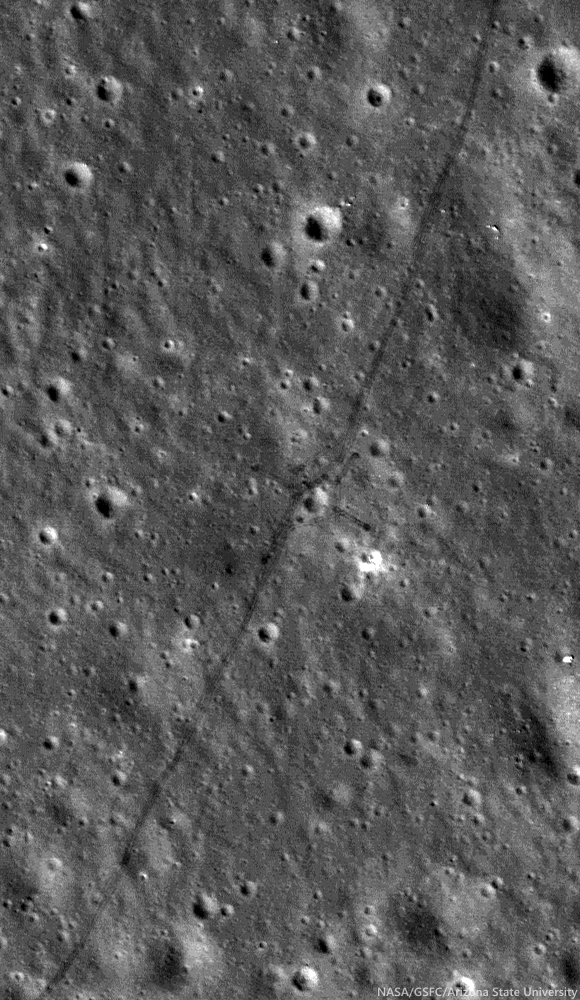
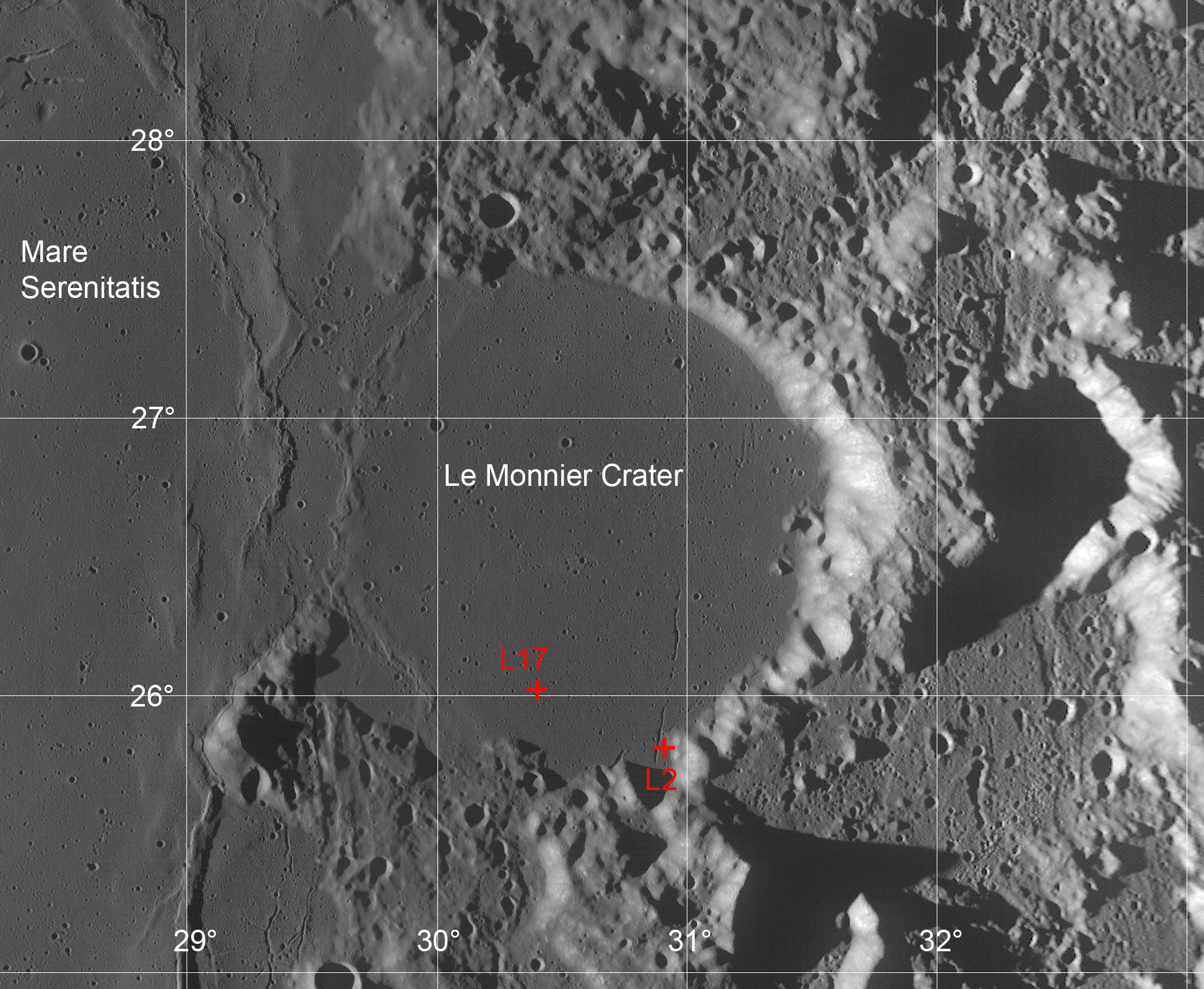
Tracks made by Lunokhod 2 in 1976 as the Soviets tested for variations in the local magnetic field while traversing around a small crater (25.764°N, 30.474°E) inside le Monnier crater, on the eastern edge of Mare Serenitatis. From LROC NAC observation M122007650R, LRO orbit 3114, February 28, 2010; 36.59° incidence angle, resolution 50 cm from 43.89 km [NASA/ GSFC/ Arizona State University].
Mark Robinson
Principal Investigator
Lunar Reconnaissance Orbiter Camera
Arizona State University

On 15 January 1973, just one month after the successful Apollo 17 mission culminated the US Project Apollo, the Soviet Luna 21 spacecraft landed softly just 170 km north of the Apollo 17 site on the eastern margin of Mare Serenitatis.

A day later on 16 January the rover Lunokhod 2 disembarked and, on 18 January, with a full battery charge it circumnavigated and imaged its faithful lander and began its record-setting journey across the lunar landscape.

The eight-wheeled rover was operated by controllers in Simferopol, Crimea, mainly using a mast-mounted TV camera and ‘joystick’ controls and roved the lunar surface for five Earth months, surviving four bitterly cold lunar nights (as low as -150 °C (-240 °F)) and racking up about 39 km (~24.4 miles) of traverse distance.

The original reported distance was 37 km, which made Lunokhod 2 the planetary rover traverse distance record holder! Along its traverse, Lunokhod 2 carried out a series of scientific experiments that were not well publicized in the United States.  Today’s Featured Image shows a cross-like pattern of rover tracks made as Lunokhod 2 explored a small crater, making various scientific measurements.

A typical Lunokhod operations crew included a commander, a navigator, a driver, an engineer, a radio/antenna operator, and one man in reserve.

Panorama taken by Lunokhod 2 at the crater shown in LROC NAC observation M122007650R (cropped from L2_D03_S03_P05m). The main experiments at this location were to test for changes in the local magnetic field due to the crater and characteristics of the regolith [Courtesy of Roskosmos and Russian Academy of Sciences].
Tracing the tracks in LROC NAC images, with new accurate geodetic controls that incorporate the latest topographic information from LROC and LOLA, the length of the Lunokhod 2 traverse is now accurately determined and is greater than the originally estimated 37 km.  In fact, the intrepid Lunokhod 2 traversed approximately 39 km!  The new traverse measurements were carried out by scientists at Moscow State University, and then again by a team at Washington University in St. Louis. The distance measurements follow the complete route shown by the tracks: including a “tripled” segment about 2 km in length, several long, linear magnetometer traverses, and several impact crater crossing maneuvers.

Lunokhod 2 traverse overview, low resolution version of six NAC image mosaic (original 1.3 m pixel scale), Sun from the west (see also Abdrakhimov, 42nd LPSC 2011) [NASA/GSFC/Arizona State University].
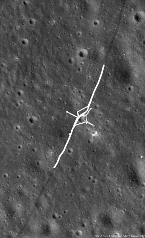
LROC NAC M122007650R, with portion of Lunokhod 2 rover tracks highlighted, where instruments gathered magnetometer measurements and did a triple traverse. Small circles can also be seen where the Lunokhod turned in place to take panoramic images [NASA/GSFC/Arizona State University].
Exploring Hilly Terrain

During the Lunokhod 2 mission, as the deputy leader of the Scientific Team and leader of the Geology Group, Dr. Alexander “Sasha” Basilevsky worked tirelessly to maximize the science return of the mission. Meeting this goal was not so easy because the Managing Group (Crew plus representatives of Lavochkin Association, which built the Lunokhods) was mostly thinking about demonstrating the roving and control capability of Lunokhod 2, and establishing a new distance record. Dr. Basilevsky recounts,
“So when moving south from the landing point, we crossed the mare area and reached a hilly terrain (low "highland" terrain).  I was planning to study it and then to go north and then east towards a graben later called Fossa Recta. But the managing team did not like long sessions of TV stereo-imaging and other measurements, and they sent Lunokhod back to the north despite my protests.
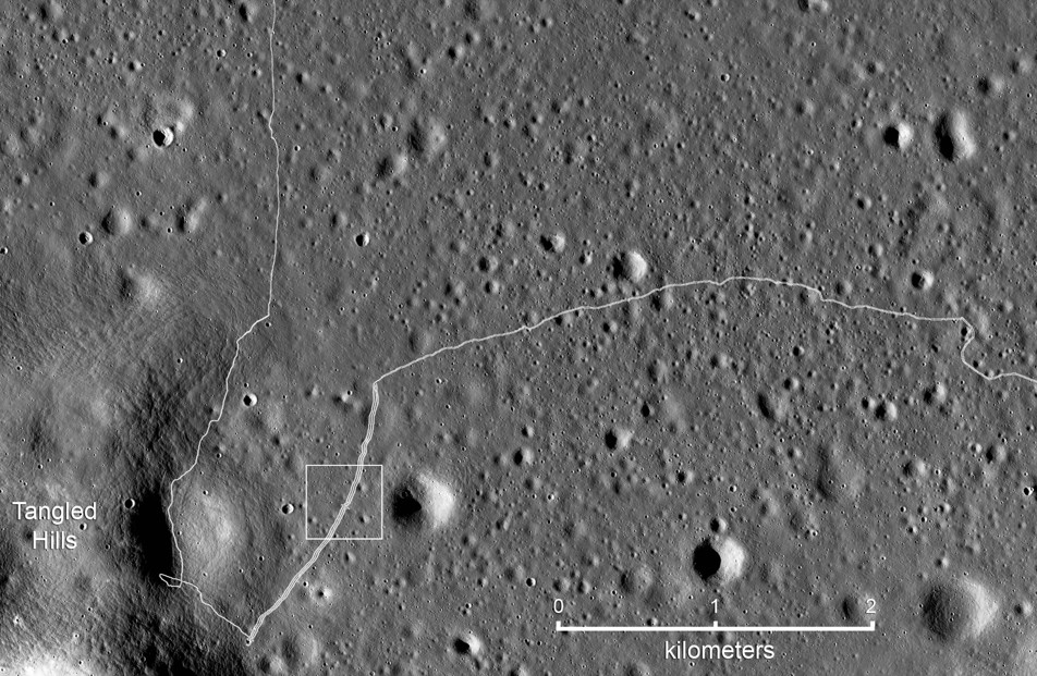
Detail map of the SW portion of the Lunokhod 2 traverse. White box indicates the field of view shown at high-resolution in the LROC Featured Image released May 2014 [NASA/GSFC/Arizona State University].
“So I called to Moscow to the head of my laboratory, Professor Cyrill Florensky, he called to Vice President of Academy of Sciences Academician Alexander Vinogradov, and Vinogradov called Sergei Kryukov, the Lavochkin Association director, and explained that the hilly terrain had to be studied. Kryukov agreed and called to the Lunokhod Control Center in Crimea where we were and said, ‘please, follow the suggestion of that guy Basilevsky.’
“Meanwhile Lunokhod 2 proceeded quite a long way. After the Kryukov call worked, the crew just turned the vehicle back and then drove along the track. That was safe and they could be fast. When Lunokhod 2 came back to the hilly terrain station we made several panoramas, and then drove back to north along the double track and again could be fast.
“So the result was good for both sides of the [issue]: For science: we studied [the hilly] terrain, and for the Managing Group: Lunokhod made a lot of meters.”
At the conclusion of the ‘tripled’ traverse segment, Lunokhod 2 had racked up about 17 km of odometry. Controllers then began the long eastward drive to Fossa Recta (‘Straight Rille’), crossing Fossa Inconspicua (‘Unnoticed Rille’) along the way. Magnetometer experiments were done along the tripled traverse to test for effects related to the mare-highland boundary, and later, on the east and west sides of Fossa Recta (see below). Other observations and measurements included soil compositional analyses using an X-ray fluorescence spectrometer, soil mechanics experiments using a penetrometer, solar X-ray monitoring, a photodetector to detect UV light sources and the level of Earth-glow on the night-time Moon, laser ranging, 86 panorama photos, and some 80,000 TV pictures. The laser ranging retroreflector, a French instrument, is still in use today.

Fossa Recta Exploration

On its fourth lunar day of roving, Lunokhod 2 explored a linear depression (graben or rille), Fossa Recta. After approaching the depression, the Lunokhod was driven along a path leading away from its edge to measure any changes in the local magnetic field associated with the depression, and then back along the same path to the edge again.  By reversing its direction and retracing its path, the effect of the Lunokhod, itself, on the magnetic signal could be determined and subtracted from the signal. A portion of the panorama taken by Lunokhod 2 when it approached the graben of Fossa Recta is shown below.

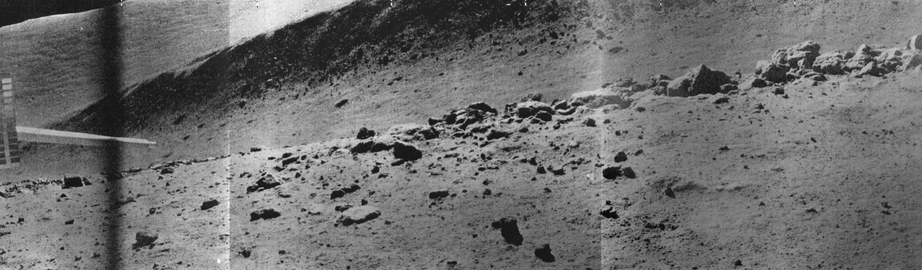
Part of the Panorama (L2_D04_S11_P09m) showing a portion of the Fossa Recta, stretching from north (left) to south (right) and a boulder field in the foreground. The sharp object on the left side of the panorama is the soil penetrometer [Courtesy of Roskosmos and Russian Academy of Sciences].
When the panorama was taken, Lunokhod 2 was on the western edge of Fossa Recta, at the position shown above, and boulders on the very edge of the depression are readily seen. The boulders were described in a paper by Basilevsky, Florensky, and Ronca (1977) in a scientific journal, The Moon, Vol. 17, and interpreted as boulders derived from lava bedrock at the edge of a long linear depression.  The characteristics observed at the edge of the fossa are similar to those seen by Apollo 15 astronauts Dave Scott and Jim Irwin at Hadley Rille. After exploring Fossa Recta Lunokhod 2 was nowhere near done!

Related Posts

Monday, September 17, 2012

Close-up on the lonely trail of Lunokhod-2

Long and winding road of the last rover deployed on the Moon, Lunokhod-2. Image cropped from a diagonal slice through the rover trail swept up in an extreme close-up of Le Monnier crater August 14, 2012. LROC Narrow Angle Camera (NAC) frame M168000478R, LRO orbit 9892; resolution 41 cm per pixel, angle of incidence 47.65° from 22.11 kilometers [NASA/GSFC/Arizona State University].
The Soviet Union's Lunokhod-2, riding to the lunar surface on the Luna-21 lander, arrived on the Moon January 15, 1973. The 84 kg. rover Lunakhod-2 was afterward deployed and, with the benefit of a robust radioisotope thermoelectric generator to warm itself through the long lunar nights, was teleoperated a total of 37 km, across the southern floor of le Monnier crater, until the following June.

It's not quite as easy to distinguish the twin ruts of the Lunakhod trail in the mosaic of both the right and left-hand frames of LROC NAC observation M168000478. The unusual close-up, from less than half the nominal 50 km altitude, was caught as flight directors prepared to raise LRO's orbit to above 100 km at the end of 2011. Because the camera was considerably closer to the surface, the field of view is quite a bit more narrow, in compliance with the Inverse Square Law, slightly less than one-half kilometer across. LRO was slewed a full 25° off nadir, which resulted in the right-hand frame being very slightly more distorted than the left [NASA/GSFC/Arizona State University].
LROC principal investigator Mark Robinson discussed the Lunokhod-2 mission in detail on March 13, HERE. Also, there are spacecraft panoramas and close-ups of both Luna-21 and Lunokhod-2 at the following links:

Lunokhod-2 revisited (March 13, 2012)
Luna 21 (March 20, 2010)
Lunokhod-1 and Lunokhod-2 (March 17, 2010)

Phil Stooke's familiar survey of the Lunokhod-2 traverse is seen here graced with the scaled mosaic of LROC NAC M168000047, at lower left. The small white box shows the field of view seen at 41 cm resolution in the opening image, above [Google Earth].
ILIADS application perspective of le Monnier, LROC Wide Angle Camera 100 meter global monochrome mosaic draped over LOLA 128 ppd digital elevation model (v.2) [NASA/GSFC/Arizona State University].

Tuesday, March 13, 2012

LROC: Lunokhod 2 revisited

The tele-operated Soviet Lunokhod 2 rover, the last lunar rover deployed on the Moon, parked facing southeast with the lid still open 39 years later. Rover tracks extend north to this final parking place. The inset is a zoomed in view, the main body is labeled B and open lid labeled L, with the instrument suite (including its French-built laser-ranging retro-reflector array, still in use) on the front labeled I. LROC Narrow Angle Camera (NAC) observation M175070494, orbit 10934, November 4, 201; resolution 30 cm per pixel [NASA/GSFC/Arizona State University].
Mark Robinson
Principal Investigator
Arizona State University

The Lunokhod 2 rover is still parked on the floor of the crater Le Monnier (25.830°N, 30.914°E). This NAC image was taken when the spacecraft was only 24 km above the surface, zipping along at about 1.6 km/sec (about 3600 mph). The spacecraft had to turn on its axis 27° to view the rover. The resolution is about two times higher than usual!

The Lunokhod 2 rover was carried to the surface on board the Luna 21 spacecraft. Lunokhod is the English translation of the Russian word “Луноход”, meaning Moon Walker. The ensemble was launched on 11 January 1973 and the landing occurred on 15 January in Le Monnier crater on the eastern margin of Mare Serenitatis. The coordinates of the landing site are 26.005°N, 30.406°E (on the basis of nine observations) at an elevation of -2769 m (1734630.9 m radius).

Le Monnier crater lies on the eastern wall of the Serenitatis basin. Lavas that compose Mare Serenitatis also flooded the floor of this 61 kilometer diameter ancient crater. The two red crosses indicate the locations of the Luna 21 lander (L21) and the ultimate  parking spot of the Lunokhod 2 rover (L2) after enduring three full lunar nights. View the original full resolution context image HERE [NASA/GSFC/Arizona State University/USGS/JAXA/Phil Stooke/Google].
Lunokhod 2 is about 170 cm (5’ 7”) long x 160 cm (5’ 3”) wide x 135 cm (4’ 5”) tall, and it is almost circular when viewed from above. The vehicle had eight wheels and could travel at either 1 km/hr or 2 km/hr (0.6 and 1.2 mph). The lid on the top of the rover served to provide solar power and to keep the vehicle warm at night. When the lid was opened, the solar cells collected energy to operate the rover. At night, the lid was closed and a fluid heated by the decay of Polonium-210 kept the rover warm. The rover was controlled remotely by a team of Soviet controllers on Earth.

Lunokhod rover in publicity still. Note the mesh wheel design and LRRR on the extended instrument suite housing [Russian Space Academy].
During its 37 km traverse, Lunokhod 2 headed south from the landing site and into the highlands from the southern rim of Le Monnier crater. Lunokhod 2 had difficulty on the slopes of the southern rim so it was turned northward and commanded to backtrack to the flat mare basalts that form the floor of Le Monnier. It then continued eastward across the crater floor eventually encountering a 250 wide north-northeast trending rille named Fossa Recta (Straight Rille).

The Luna 21 lander with ramps deployed on both sides,
to the northwest and to the southeast. LROC NAC
M122007650L [NASA/GSFC/Arizona State University].
Lunokhod 2 drove off the lander to the northwest and circled around to the east. Several turns were made as the rover photographed the lander. It then departed and headed south.

The rover had to work its way down the rille wall and across the floor before finally climbing out on the east side. Lunokhod 2 continued north before reaching its final position. The mission officially ended on 4 June 1973 due to a failure of the rover. Apparently on 9 May, the rover’s lid touched a crater wall and become covered with fine-grained lunar regolith. That regolith was dumped onto the radiators when the lid closed. Subsequently, when the lid opened, the rover overheated and failed.

The scientific payload on the rover included three television cameras for navigation, four panoramic cameras, a cone penetrometer to test the lunar regolith, a solar X-ray experiment, a magnetometer, radiometer, and laser ranging retroreflector.
Luna 21 lander as seen from the Lunokhod 2 rover. This view as taken from south of the lander looking to the northwest. The tracks around the east side of the lander are quite apparent, note the small berms of regolith that were pushed up as the rover turned. Lunation 1, Session 4, Panorama 12 [RSA]..
Examine the regional geology that Lunokhod 2 was exploring, HERE (hint: sample 4493, line 15645; look to the south for some spectacular rover tracks).

First LROC Featured Image of the Lunokhod rovers.

Thursday, April 1, 2010

Absentee ownership of Lunokhod 2


Garriott Crater? Even when a story is picked up and echoed in multiple corners of the Blogosphere, and may or may not be sprinkled with facts, doesn't make it true, especially but not exclusively on All Fools Day. Perhaps the video-mogul and space tourist from a family of astronauts does have a claim on this corner of the Moon. If so, his claim is staked between the Luna 21 lunar lander carrier and writ in the tracks of Lunokhod 2, with a location long-verified by laser reflection and most recently photographed in situ by the Lunar Reconnaissance Orbiter [Google Earth].

Richard Garriott now thinks the possibility of one day visiting the last rover to land on the Moon, which he bought for $68,000 in 1993, has gone from a zero probability to a long shot.

Andy Chalk
the escapist

In 1993 Richard Garriott purchased the former Soviet Union's Luna 21 moon lander and its Lunokhod 2 moon rover at a Sotheby's auction for $68,000... Luna 21 landed on the lunar surface on January 15, 1973, and its Lunokhod passenger remained operational until May 9, when it accidentally rolled into a crater and was buried under dust, ending its mission.

[Ed Note: This last piece of information is definitely not completely accurate. The french-built lunar laser range reflector on Lunokhod 2 continues to return the occasional photon, defying the author's inference that the vehicle was "buried under dust."]

Or so it was thought. But last week, a camera on NASA's Lunar Reconnaissance Orbiter sent home pictures of the wayward rover, parked safe and sound on the surface of the moon. "It's great to actually have a contemporary photograph of my property on the moon," Garriott said. He's clearly thinking beyond just a unique piece of memorabilia, however; according to Space.com, he's also had "casual conversations with lawyers about international law and property rights on the moon."

"I think I can truly make the only private, legitimate claim to territory - at the very least around my rover and, potentially, along its point of travel, to give me some actual property rights on the moon," Garriott said. And while he admitted that his claim is "somewhat tongue in cheek," he added, "It is interesting speculation... And I think that there's already international framework to support that territorial claim."

Unfortunately for Garriott, Joanne Irene Gabrynowicz, the director of the National Center for Remote Sensing, Air and Space Law and Research Professor of Law at the University of Mississippi, said his claim is off-base. "A contention that buying a space object that landed on the lunar surface from a sovereign nation gives rise to a property right to the territory under it is wrong," she said. "The U.S.S.R. was and Russia is a party to the Outer Space Treaty. It did not acquire the territory under the object when it landed. One cannot sell what one does not own. Since U.S.S.R./Russia did not have a property right to the territory under the landed object, there was nothing to sell."

Regardless of whose legal opinion prevails, Garriott now holds a new hope: That one day he'll get to see his lunar rover in person. "If you would have asked me [about going to the moon] in 1993 when I acquired Lunokhod 2 I would have said [the odds are] pretty close to zero. It's still a very low probability... But the probability is dramatically higher than it was," Garriott said. But the new "private space race" has changed all that. "As long as I keep myself healthy," Garriott said, "there's reasonable odds I can get a chance to go visit it. It has gone from zero probability to just a long shot."

Read the balance of this fanciful opinion piece, HERE.