Friday, November 30, 2012

Solar eclipse from 37 kilometers up


Jason Major
Universe Today

"By launching a weather balloon carrying a wide-angle camera into the stratosphere above Queensland, eclipse hunter and amateur astronomer Catalin Beldea and her team were able to obtain their incredible video of the November 14 total eclipse from high enough up that the shadow of the Moon was visible striking Earth’s atmosphere. Totality only lasted a couple of minutes so good timing was essential… but they got the shot. Very impressive!"

Read Jason's article, "In the Shadow of the Moon," at Universe Today, HERE.

The video was organized with and for Romania’s Stiinta&Tehnica.com by editor-in-chief Marc Ulieriu and assembled by Daniel Toma. Music by Shamil Elvenheim.

Thursday, November 29, 2012

Debris Slump Pile Up

A debris slump produced a striking array of linear features on a crater floor (30.68°S; 145.59°E). NAC frame M176684041R, resolution 51 cm per pixel over a field of view ~1 km wide, from 48.32 km [NASA/GSFC/Arizona State University].
James Ashley
LROC News System

Almost all lunar craters show evidence of mass wasting (slumping/avalanches) in their walls. Occasionally a crater is found where post-impact wall modification occurs non-uniformly along the crater rim, causing an asymmetric crater outline. This unnamed crater on the lunar farside highlands may show an example of this type of behavior. A slight enlargement of the crater diameter is visible along the southwestern rim (see WAC mosaic frame below), coincident with a voluminous deposit of slumped material on the crater floor. This material likely slumped shortly following the original crater excavation.

A variety of interesting floor patterns are visible in this deposit. As portions of debris reached the floor, lost energy, and ground to a halt, material still in motion piled up behind, producing a series of en echelon fault-like structures in the unconsolidated mound.

A wider view of M176684041R shows extent of these features. Field of view ~2.4 km wide [NASA/GSFC/Arizona State University].

The final deposit is over 7 km wide. Resting loose on its upper surface are high-reflectance boulders in what appear to be linear arrays at rough right angles to the fault strikes. What might have caused this arrangement among the rocks? Are they ejecta from another impact, or related to the featured crater? It is quite possible that they simply represent the fragmentation of large blocks that rolled down the slope and broke up as they encountered the rugged terrain below. What additional clues could you look for to find a definitive answer?

WAC mosaic field of view ~106 km wide [NASA/GSFC/Arizona State University].

A larger portion of this deposit can be seen in the full NAC image HERE. Areas affected by ejecta from this impact were recently explored in Scours and Ejecta Near Jules Verne Y. An example of a strongly asymmetric crater rim is covered in Ryder Spectacular!

Wednesday, November 28, 2012

Lassell D Ejecta

A variety of effects are still visible from this recent impact in Mare Nubium (14.60°S; 10.26°W). LROC Narrow Angle Camera (NAC) frame M111660844L, LRO orbit 1589, October 31, 2009; illumination from the east, north is up, from full field of view, approximately 1 kilometer wide, 51 cm per pixel resolution from 49.13 km altitude [NASA/GSFC/Arizona State University].
James Ashley
LROC News System

The complex geologic process of impact cratering often results in a diverse medley of landforms and other surface features. The more nuanced of these are best observed in fresh craters because the subtlest attributes of impacts are those most easily removed by space weathering. Lassell D crater (2 km diameter) has been described as "one of the freshest craters on the Moon" (Muller, et al., 1986). 

In the proximal (nearby) ejecta blanket we see a hummocky, streaked surface with dune-like forms, ribbon-shaped lobes, and an eye-catching admixture of low- and high-reflectance soils. Immediately following the high-energy of impact, advancing walls of ejecta hugged the ground and moved like a dry tsunami across this region.

The west interior and ejecta blanket of Lassell D. The area detailed in the LROC Featured Image is on the crater's eastern flank, outside the field of view above, capturing the rough, young crater's sharp features on an earlier pass. The 5 km field of view above is from a mosaic of the left and right frames of LROC NAC M135257059, spacecraft orbit 5066, July 31, 2010; incidence angle 59.64° at 50 cm resolution from 46.63 km [NASA/GSFC/Arizona State University].
The crenulations are the result of mechanical interactions of the moving debris with pre-existing topography. As the wave of rock and dust is arrested by this resistance, some portions of the debris continue flowing while others slow and stop moving. The result is a wavy landform, a cross-section of which might reveal how the lobes partially rode up and over each other, hence the descriptive term "imbricated deceleration lobes."

LROC Wide Angle Camera (WAC) mosaic as context, from original image 118 km-wide field of view, resampled with added contrast to, perhaps unnecessarily, bring out from the background the subtle fresh and widespread ray system of Lassell D [NASA/GSFC/Arizona State University].
As regolith redevelops and matures over the tens of millions of years to come, these features will gradually diminish. Which features would disappear first and why? Examine the full NAC frame HERE. Additional examples of fresh impact features can be found in Kamarov, Icarus, and The Lavish Lobes of Necho R.

Lassell D's affect on the Lassell Massif (above and below), to the east. The massif and crater group, a spectral "Red Spot," is speculated to be intrusions of silicate-rich lava characterized by a higher viscosity than the Moon's far more common pyroclastic domes. The feature shows a much lower iron-oxide concentration than the surrounding basalt plains and marks the southwest border of a high thorium signature. LROC WAC observation M129350040C (604nm) [NASA/GSFC/Arizona State University].
From a 2010 demonstration, animation of separate LROC WAC observations of the geologically interesting Lassell Massif and crater group east of Lassell D, showing the latter's fresh ray system intruding from the west. This is more easily discerned under a high Sun while topography is easier to view under a mid-morning Sun in the east-northeast. The bright, widespread ejecta streamers from Lassell D alternates with a visible chevron affect by the Lassell D pressure front [NASA/GSFC/Arizona State University].

Tuesday, November 27, 2012

New study answers lunar exploration concepts outlined by National Research Council in 2007

A highly resampled oblique view of the vent formation within Schrödinger basin, in the far south of the lunar far side. The basin represents a relatively new formation the excavation of which appears to have uncovered rich detail of earlier lunar morphology. LROC NAC observation M121415248LR [NASA/GSFC/Arizona State University].
A significant lunar landing site study released Monday, by the Center for Lunar Science and Exploration, addresses priorities set out in 2007 in a very influential report released by the National Research Council's Space Studies Board, The Scientific Context for the Exploration of the Moon.

Over a five year period, eight summer study groups researched our present understanding of the Moon, including voluminous new data returned by the Lunar Reconnaissance Orbiter (LRO) since 2009, and addressed central concepts outlined by the National Research Council in 2007 in a detailed report entitled A Global Lunar Landing Site Study to Provide the Scientific Context for the Exploration of the Moon.

Co-editors David A. Kring and Daniel D. Durda made their announcement online, Monday, November 26.

“The Moon is still largely unexplored. The work captured here will hopefully point mission planners to the most productive science and exploration sites on the Moon. We are ready to get back on the surface of the Moon and spark another era of discovery.

“As this study unfolded, it became clear the Apollo landing sites, while completely re-shaping our understanding of the solar system 50 years ago, represent only a tiny fraction of the lunar surface. Other sites can reveal completely new details of lunar history and are, arguably, better sites for addressing the fundamentally important issues identified in the NRC (2007) report The Scientific Context for Exploration of the Moon.

“This study asked a simple question, where on the lunar surface could the objectives in the 2007 report? Maps keyed to each of those objectives were created and, when those maps were stacked, several lunar surface locations popped out as the scientifically-richest landing sites.

Citing a few examples of highlights from the report, Kring wrote, “Schrödinger basin, on the lunar far side and within the ancient South Pole-Aitken basin, is the location where the largest range of objectives can be addressed. 

Very small scale laser altimetry (LOLA)-based topography shows the Schrödinger basin region of interest, and the Amundsen basin, in context with Shackleton crater and the lunar South Pole [NASA/LMMP].
For studies of polar volatiles, including water ice, Amundsen basin may be a better target than Shackleton crater. “But to truly resolve all of the NRC (2007) objectives,” wrote Kring, “ global access to the Moon is required.”

The report identifies a huge number of other productive landing sites across the lunar surface. "Not surprising," Kring wrote, "some favorites from the past, like Mare Orientale, appear in the report, but some surprises also emerged."

The study is available online, in Adobe Reader format at http://www.lpi.usra.edu/nlsi/CLSE-landing-site-study/

FIGURE 4.25 (Science Concept 4 Discussion) Amundsen Crater interior, showing (Permanently Shadowed Regions PSRs - dark blue), sites where all five Science Concept 4 Science Goal can be met (light blue), proposed landing sites (stars), and proposed science stations (circles). Radii of 10 and 20 km from the landing sites are shown as solid and dashed lines, respectively. Temperatures  within parts of the local PSR are never higher than 54°K - Base map is LRO/WAC/LOLA shaded relief.
The report is the product of an immense amount of work by eight student teams working through the Lunar and Planetary Research Institute and Johnson Space Center Lunar Exploration Summer Intern Program. These students had the technical skills to digest the scientific and exploration concepts, define the lunar surface requirements those concepts imply, process relevant spacecraft and sample data, and then produce maps of suitable landing sites.

Seven of the teams examined Concepts I through VII in the NRC's 2007 report.  Prompted by NASA, an eighth team took a closer look at the South Pole-Aitken basin to determine which objectives could be addressed within there. Teams did not evaluate Concept VIII in the 2007 report because it should soon addressed by the LADEE spacecraft scheduled for launch in 2013.

"The report is released with a single caveat," according to Kring. "The results represent a series of summer studies and are not intended to provide final detailed descriptions of landing sites. Still, this landing site study provides a comprehensive and global assessment of the NRC's 2007 science goals for the exploring the Moon.

"It is an excellent foundation for more detailed studies once specific missions are being planned."

Monday, November 26, 2012

NLSI Director's Seminar Series, Live Online Nov. 27

Jack Burns
University of Colorado at Boulder

Tuesday, November 27, 2012
1800 UTC - 10AM PST, 1PM EST

The NASA Lunar Science Institute (NLSI) Lunar University Network for Astrophysics Research (LUNAR) is a team of researchers and students at leading universities, NASA centers, and federal research laboratories undertaking investigations aimed at using the Moon as a platform for space science.

LUNAR research includes Lunar Interior Physics & Gravitation using Lunar Laser Ranging (LLR), Low Frequency Cosmology and Astrophysics (LFCA), Planetary Science and the Lunar Ionosphere, Radio Heliophysics and Space Radiation, and Exploration Science. The LUNAR team is exploring technologies that are likely to have a dual purpose, serving both exploration and science.

Larger laser range reflector deployed at Hadley
Rille Delta by Scott and Irwin of Apollo 15 in
February 1971, a still active component of that
missions ALSEP and today an effort to constrain
the measured distance to the Moon to determine
locality, if any, of cosmological physics.
In this talk Dr. Burns will describe how LUNAR researchers are using LLR to provide the most precise constraints on General Relativity and gravitation, how low frequency radio observations of the Sun will assist us in understanding and predicting solar radiation that propagates throughout interplanetary space, and how low radio frequency telescopes in lunar orbit and on the lunar farside will allow us to probe the first stars and galaxies during the early Universe’s Cosmic Dawn.

Dr. Burns will also describe our development of new human/robotic mission concepts, including a mission to the Earth-Moon L2 Lagrange point, where astronauts in the Orion spacecraft will teleoperate rovers for geological exploration and for deployment of a low radio frequency array.

To Join Live Video Conference via browser (Adobe Connect) and to view slides : http://connect.arc.nasa.gov/nlsi_directors_seminar/

To Join via Video Conferencing System, RSVP Ricky Guest only if joining by Polycom or other standards-based Video Teleconferencing System.

Burns is a professor in the Department of Astrophysical and Planetary Sciences and Vice President Emeritus for Academic Affairs and Research for the University of Colorado at Boulder.  He is also Director of the NASA Lunar Science Institute’s Lunar University Network for Astrophysics Research (LUNAR), a NASA-funded center and part of the NASA Lunar Science Institute. Burns received his B.S. degree, magna cum laude, in Astrophysics from the University of Massachusetts, and received his doctorate in Astronomy from Indiana University.

From 2001 - 2005, Burns served as Vice President for Academic Affairs & Research for the University of Colorado System.  Burns was Vice Provost for Research at the University of Missouri – Columbia from 1997 through 2001. He was Associate Dean for the College of Arts and Sciences at New Mexico State University (NMSU) and served as Department Head and Professor in the Department of Astronomy at NMSU from 1989 until 1996.

Dark Ages Radio Explorer (DARE), utilizing the radio-quiet of the lunar farside to explore the earliest period on the cosmic time line, 200 million years between the primordial Big Bang and the emergence of the earliest luminous sources and the structure of the present universe. "The lunar Farside is potentially the only site in the inner solar system for high precision radio cosmology.” Illustration accompanying post "Farside offers radio quiet to probe Cosmic Dark Age," July 2, 2012 [NLSI].
During his tenure at the University of New Mexico from 1980 to 1989, Burns served as the Director of the Institute for Astrophysics, and he was a Presidential Fellow. He was a postdoctoral fellow at the National Radio Astronomy Observatory from 1978 to 1980.

Burns has over 380 publications in refereed journals, books, and in conference proceedings and abstracts (listed in NASA’s Astrophysics Data System). He is an elected Fellow of the American Physical Society and the American Association for the Advancement of Science and received NASA’s Exceptional Public Service Medal in 2010 for his service on the NASA Advisory Council (NAC) and as Chair of the NAC Science Committee.

Related Posts:

Saturday, November 24, 2012

Earthviews: Ohio Lunar Halo, from September

John Chumack, East Dayton, Ohio, September 30, 2012 [USRA].
Among the great pile of neglected posts set aside as we busied ourselves with a project requiring all our attention in recent weeks was an Earth Science Picture of the Day (EPOD) capturing the glory of our large natural satellite two days after September's Harvest Moon in the skies southeast of East Dayton, Ohio. 

The original (linked to the thumbnail at left) carries either the dusk's or the cities city's sodium vapor street lights, a combination of factors adding red to the thin, relatively high-altitude ice crystals along a southeast line of sight.

We reproduced the image here, cropped and in black and white, in hope of illustrating the wispy contacts and secondary refractions more easily seen by naked eye.

Photographer John Chumack wrote, "Because Mother Nature is sometimes surprising, I always go out at look at the night sky before I go to bed, even if the forecast calls for cloudy skies."

Wednesday, November 21, 2012

ESA Lunar Lander mission axed

The EADS Astrium - European Space Agency (ESA) Lunar Lander, clinging to a 2018 landing, possibly on the rim of lunar South Pole crater Shackleton, is likely scrubbed [EAS/Astrium].
Germany's DLR has reportedly given up advocating the 2018 south polar Lunar Lander mission as ESA member nations struggle with dire discretionary budget constraints in the midst of an on-going sovereign debt crisis.

Germany dropped further efforts to secure joint European funding for Lunar Lander at an ESA budget meeting in Naples in favor of upgrades to the Ariane 5.

Meanwhile, following NASA's exit from the ExoMars orbiter-rover mission, in development since 2005, Russia's Federal Space Agency Roscosmos has become ESA's new launch partner, set to launch the orbiter half of that mission in 2016 and its tandem six-wheeled rover two years later.

Related Posts:
ESA input sought on multi-purpose lunar lander (March 2, 2009)
Astrium study of ESA NEXT lunar lander underway (June 10, 2009)
Remembering SMART-1 (September 17, 2009)
ESA: Fly us to the Moon's South Pole (March 31, 2010)
NEXT step for ESA's first lunar lander (September 16, 2010)
Astrium tests ESA Lunar Lander thrusters (March 5, 2012)
ESA's MoonNEXT boosted by ATV development (April 30, 2012)
ESA Lunar Lander still on target for 2018 (July 27, 2012)

Tuesday, November 20, 2012

Apollo 12 at 43 Years

A resampled, scale-corrected "Closet Look" at the "Pinpoint Landing" zone of Apollo 12 and Surveyor 3, originally posted here March 7, 2012. LROC Narrow Angle Camera (NAC) observation M175428601R, LRO orbit 10987, November 8, 2011. Resolution 39 cm per pixel, from only 23 kilometers overhead. The field of view is slightly less than a quarter kilometer across [NASA/GSFC/Arizona State University].
A pixel, and part of another (marked by the arrow) just barely discloses the Apollo 12 lunar module descent stage, on the "shoulder" of "The Snowman" crater group, this time from 106.48 kilometers above the lunar surface, from the much higher, mission conserving orbit LRO has occupied since January. Resolution was more than 3.5 meters per pixel, May 31, 2012. LROC NAC frame M193067752R. It's possible the long shadow of the mast of Surveyor 3 is visible as a bump on the shadow line in Surveyor Crater [NASA/GSFC/Arizona State University].
The full-resolution from from LROC NAC frame M193067752R (white rectangle) in the context of the 20 km-wide field of view captured from the east, with camera and spacecraft slewed 60° off nadir.
Pinpoint Landing on the Moon (Apollo 12) March 7, 2012
New Views of Apollo 12 September 8, 2011

Other LROC Images of the Apollo 12 Landing Site:
First Look: Apollo 12 and Surveyor 3
Apollo 12 Second Look: Midday on the Ocean of Storms
First Low Altitude Apollo 12 NAC Image

Sunday, November 18, 2012

Jack Schmitt holds fast to lunar vision

Apollo 17 astronauts Harrison Schmitt, second from left, and Eugene Cernan press their hands down in the wet concrete at Adler Planetarium in Chicago, November 13, 2012 [Kiichiro Sato/AP].
The Canadian Press

LONDON, Ontario -- You may have to excuse Harrison (Jack) Schmitt if the former American astronaut gets itchy feet for the moon these days. It was 40 years ago next month, on Dec. 6, 1972, that he and fellow astronaut Eugene Cernan became the last humans to set foot on the lunar surface.

If the former Apollo 17 astronaut had his way, the United States would head back to the moon first, before traveling to Mars. The 77-year-old geologist, who has his eye on lunar mining opportunities, says the commercial sector could be back on the moon within 15 to 20 years.

"I think it's important to have the commercial sector of the Western world thinking about how do you not only get to the moon but what are the economic returns of doing so," Schmitt said in an interview. He sees a role for Canada whose mining industry, he says, is very active and is an important player in the global economy. Schmitt also says humankind has the ability to put "permanent" settlements on the moon within 40 years.

Talking about his own experience, Schmitt recalled moon-walking or skiing on moon dust in December 1972. "It was like being on a giant trampoline," he told The Canadian Press. "I used a cross-country skiing technique that many Canadians are familiar with and that I had learned in Norway as a student there."

Schmitt, who was also a U.S. Senator, was the last NASA astronaut to arrive on the moon, Apollo 17 commander Eugene Cernan, who stepped off the module before him, was ultimately the last to walk on the moon.

Now, 40 years later, Schmitt expressed disappointment that humans hadn't returned to the moon: "I would have hoped we would have gotten back sooner."

Saturday, November 17, 2012

Technical Readiness

Future industrial activity on the Moon -- science fiction? (Artwork by Pat Rawlings)
Paul D. Spudis
The Once & Future Moon
Smithsonian Air & Space

Space missions are commonly thought of as the ultimate in “high tech.”  After all, rockets blast off into the wild blue yonder, accelerate their payloads to hypersonic and orbital speeds and then operate in zero gravity in the ice-cold, black sky of space.  It requires our best technology to pull off this modern miracle and even then, things can go wrong.  Why would anyone believe that with high technology, sometimes less can be more – that we’re missing a bet by not utilizing current technology.   Like the intellectual tug of war involving man vs. machine, there also is a tug of war between proven technology and high-tech.  Creating these barriers and distinctions is nonsensical.  We need it all.  And we can have it all.

Point in question – in situ resource utilization (ISRU), which is the general term given to the concept of learning how to use the materials and energy we find in space.  The idea of learning how to “live off the land” in space has been around for a long, long time.  Countless papers have been written discussing the theory and practice of this operational approach.  Yet to date, the only resource we have actually used in space is the conversion of sunlight into electricity via arrays of photovoltaic cells.  Such power generation is clearly “mature” from a technical viewpoint, but it had to be demonstrated in actual spaceflight before it became considered as such (the earliest satellites were powered by batteries).

The reason we have not used ISRU is because we’ve spent the last 30 years in low Earth orbit, without access to the material resources of space.  Many ideas have been proposed to use the material resources of the Moon.  A big advantage of doing so is that much less mass needs to be transported from Earth.  The propellant needed to transport a unit of mass from the Earth to the Moon keeps us hobbled to the tyranny of the rocket equation – a constant roadblock to progress.  If it takes several thousand dollars to launch one pound into Earth orbit, multiply that amount times ten to get the cost to put a pound of mass on the Moon.

In the space business, new technologies tend to be viewed with a jaundiced eye.  Aerospace engineers in particular are typically very conservative when it comes to integrating new technology into spacecraft and mission designs, largely on the basis that if we are not careful, missions can fail in a spectacularly dreadful fashion.  To determine if a technology is ready for prime time, NASA developed the Technology Readiness Level (TRL) scale, a nine-step list of criteria that managers use to evaluate and classify how mature a technical concept is and whether the new technology is mission ready.

Resource utilization has a very low TRL level – usually TRL 4 or lower.  Thus, many engineers don’t think of ISRU as a viable technique to implement on a real mission.  It seems too “far out” (more science fiction than science).  Believing that a technology is too immature for use can become a self-fulfilling prophecy, a “Catch-22” for spaceflight:  a technology is too immature for flight because it’s never flown and it’s never flown because it’s too immature.  This prejudice is widespread among many “old hands” in the space business, who wield TRL quite effectively in order to keep new and innovative ideas stuffed in the closet and off flight manifests.

In truth, the idea that the processing and use of off-planet resources is “high technology” is exactly backwards – most of the ideas proposed for ISRU are some of the simplest and oldest technologies known to man.  One of the first ideas advanced for using resources on the Moon involve building things out of bulk regolith  (rocks and soil of the lunar surface).  
Nothing that we plan to do on the Moon involves magic, alchemy or extremely high technology.
This is certainly not high-tech; the use of building aggregate dates back to ancient times, reaching a high level of sophistication under the Romans, who over 2000 years ago built what is still the largest free-supported concrete dome in the world (the Pantheon).  The Coliseum was made of concrete faced by marble.  The Romans also built a complex network of roads, some which remain in use to this day; paving and grading is one of the oldest and most straightforward technologies known.  Odd as it may seem, sand and gravel building material is the largest source of wealth from a terrestrial resource – the biggest economic material resource on Earth.

Recently, interest has focused on the harvesting and use of water, found as ice deposits, at the poles of the Moon.  Digging up ice-laden soil and heating it to extract water is very old, dating back to at least prehistoric times.  This water could contain other substances, including possibly toxic amounts of some exotic elements, such as silver and mercury.  No problem – we understand fractional distillation, a medieval separation technique based on the differing boiling temperatures of various substances.  Again, this concept is not particularly high-tech as only a heater and a cooling column is needed (basically the configuration of an oil refinery).  Some workers have suggested that lunar regolith could be mined for metals, which can then be used to manufacture both large construction pieces and complex equipment.  Extracting metal from rocks and minerals is likewise very old, developed by the ancients and simply improved in efficiency over time.  Processes like carbothermal reduction have been used for hundreds of years. The reactions and yields are well known, and the machinery needed to create a processing stream is simple and easy to operate.

In short, the means needed to extract and use the material wealth of the Moon and other extraterrestrial bodies is technology that is centuries old.  Even advanced chemical processing was largely completely developed by the 19th Century in both Europe and America.  The “new” aspects of ISRU technology revolve around the use of computers to control and regulate the processing stream.  Such control is already used in many industries on Earth, including the new and potentially revolutionary technique of three-dimensional printing.  A key aspect of the old “Faster-Cheaper-Better” idea (one NASA never really embraced) was to push the envelope by relying more on “off-the-wall” ideas, whereby more innovation on more flights would lead to greater capability over time.

Water, Rare Earths and metals are collected and transferred autonomically, using remotely-operated vehicles in a scenario prepared by MIT and presented a gathering of AIAA Houston last spring [John Frassanito & Associates].
Nothing that we plan to do on the Moon involves magic, alchemy or extremely high technology.  Like most new fields of endeavor, we can start small and build capability over time.  The TRL concept was designed as a guideline.  It was not intended as a weapon eliminating possibly game-changing techniques from consideration or to carve out funding territories.  Attitudes toward TRL must change at all levels, from the lowly subsystem to the complete, end-to-end architectural plan.  A critical first step toward true space utilization and for understanding and controlling our destiny there is to recognize and take advantage of the leverage one gets from lunar (and in time planetary) resource utilization.

Originally published at his Smithsonian Air & Space blog The Once and Future Moon, Dr. Spudis is a senior staff scientist at the Lunar and Planetary Institute. The opinions expressed are those of the author and are better informed than average.

Friday, November 16, 2012

APOD: "Moon Shadow Sequence"

On the morning of November 14, the Moon's umbral shadow tracked across northern Australia before heading into the southern Pacific. Captured from a hilltop some 30 miles west of the outback town of Mount Carbine, Queensland, a series of exposures follows the progress of the total solar eclipse in this dramatic composite image. The sequence begins near the horizon. The Moon steadily encroaches on the on the reddened face of the Sun, rising as the eclipse progresses. At totality, lasting about 2 minutes from that location, an otherwise faint solar corona shimmers around the eclipsed disk. Recorded during totality, the background exposure shows a still sunlit sky near the horizon, just beyond a sky darkened by the shadow of the Moon.
- NASA "Astronomy Picture of the Day" (APOD) - 16 November 2012

Thursday, November 15, 2012

"Clusters"

Cluster of secondary craters about 12 kilometers southeast of farside mid-latitude crater Rayet Y. LROC Narrow Angle Camera (NAC) observation M182796787R, LRO orbit 12041, February 2, 2012; field of view 1.68 km, centered on 46.892°N, 113.807°E, resolution 1.68 meters from 171.53 km overhead [NASA/GSFC/Arizona State University].
Hiroyuki Sato
LROC News System

Today's Featured Image displays a classic set of aligned craters, most likely formed as a swarm of secondary impactors hit the surface. The location of this cluster is only about 10 km southeast of Rayet Y crater (14.5 km in diameter). But since the cluster extends in a northeast-southwest direction that does not point back to Rayet Y, the source of these secondary craters must be another crater. Giordano Bruno is one possible candidates in terms of the direction and maturity (similar or younger in age than Rayet Y), even though it is over about 450 km away.

For age dating small and young surfaces with crater counts, secondary craters introduce a serious problem. As the image resolution increases, we can count more small craters from a small portion of the ground, giving the impression of an increase in the accuracy of age estimates. However, secondary craters are more common at small diameters and their distribution is not random over small areas, violating one of the principal assumptions of age dating via crater counting. Counting secondaries in addition to the normal random population of primary craters can result in an artificially older age estimate for a surface.

So how can we determine if secondaries are present? One of the definitive signs of secondary craters is the clustering shown in the opening image. Random impacts over time typically don't result in such local high densities. Secondary craters can also have a V-shaped pattern in their rays, known as a "herringbone" pattern, seen for some of the craters above. Counts of craters thus try to exclude clusters and irregularly shaped craters to minimize errors in age estimates introduced by secondaries.

Rayet Y crater and surrounding area from LROC Wide Angle Camera (WAC) monochrome mosaic (100 meters/pixel). Original image centered near 46.56°N, 113.42°E, cropped frame above covers a field of view approximately 168 kilometers across. The blue rectangle shows the full LROC NAC footprint of observation M182796787R and the white arrow indicates the location included in the LROC Featured Image released November 15, 2012 [NASA/GSFC/Arizona State University].

Explore the typical secondary craters in full NAC frame HERE.

Related Posts:
Stream of Secondary Craters
Regolith on Basalt
Impacts on the Melts
Dark Secondary Crater Cluster
Bench Crater
Cluster of farside secondary craters

A different perspective on secondary craters, a definite cluster of "secondaries" from an oblique LROC NAC observation of the Mee crater group far to the south of Mare Humorum on the near side. LROC NAC observation M127232206 [NASA/GSFC/Arizona State University].
A small chain of small secondary craters 12 kilometers southeast of Rayet Y are radiant from Giordano Bruno, nearly 400 km to the southwest [NASA/GSFC/LMMP/Arizona State University].

Layers of Imbrium floor excavated at Piton B

Southern contact of Piton B crater wall and rim. From LROC Narrow Angle Camera (NAC) observation M168203756R, orbit 9922, August 17, 2011; 290 meter-wide field of view captured from a mere 28.75 kilometers, resolution 42 centimeters per pixel, centered near 39.292°N, 359.883°E. North is up [NASA/GSFC/Arizona State University].
Hiroyuki Sato
LROC News System

Piton B is a young, fresh crater (about 4.5 km diameter) located in northeast Mare Imbrium. Along the upper part of this young crater wall, you can find clear layering similar as seen in Meteor Crater at east of Flagstaff, Arizona. The opening image highlights such layerings observed at the southern crater wall of Piton B.

In the lower right corner of this image is a portion of the crater rim, downslope is toward the top. The relatively resistant layers discontinuously outline their horizontal expanses. Among them, the blocky outcrop at the center of this image shows the clearest bedding plane. 

The thinnest layers are roughly 3 to 4 meters thick, assuming a slope angle about 30°.

Context for the Featured Image field of view (white rectangle) in the full width of the left and right frame of LROC NAC observation M168203756 [NASA/GSFC/Arizona State University].
Layer thickness estimates from orbital views are not as accurate as geologists would make standing on the outcrop, but many measurements at multiple craters give a great estimate of the general layer thicknesses of the original lava flows. Knowing thickness of flows helps us understand the viscosity and flow rates of ancient mare volcanism.

Piton B (below center) in LROC Wide Angle Camera 100 meter resolution mosaic on LOLA laser altimetry based topography from a simulated perspective 14 km over the vast Imbrium floor. Beyond are Piton A and their namesake Piton Mons [NASA/GSFC/Arizona State University].
Explore the fresh crater wall of Piton B in full NAC frame yourself, HERE.

Related Posts:

Wednesday, November 14, 2012

Craters, Old and New

Unnamed craters on the western edge of Mare Frigoris. 1.65 kilometer-wide field of view from LROC Narrow Angle Camera (NAC) frame M186056576L, centered on 56.579°N, 334.890°E. Captured during LRO orbit 12497, March 10, 2012, resolution 1.66 meters per pixel from 168.15 kilometers [NASA/GSFC/Arizona State University].
Hiroyuki Sato
LROC News System

Today's (Tuesday, November 13, 2012 - LROC) Featured Image highlights contrasting features of a young (lower right) and old (upper left) crater with nearly the same diameters (about 450 meters). These two craters are found in the western portion of Mare Frigoris, 23 kilometers south of La Condamine S.

The walls of of the younger crater are steeper with a small, nearly flat floor, probably from pooled impact melt. The older crater appears much shallower and flatter due to an extensive amount of infilling. This type of degraded flat-floored crater is common on the maria.

Many of the craters in this area appear to have roughly the same amount of infilling. Why? Perhaps a local resurfacing event occurred, meaning the infill could either be a product of volcanic activity or impact ejecta. If we visit one of these infilled craters and dig a trench or two we could determine whether this infilling material is volcanic or impact ejecta.

Surrounding areas of La Condamine S crater in LROC WAC 100 meter/pixel mosaic on LOLA laser altimetry using NASA Lunar Modeling and Mapping Project (LMMP) application ILIADS. The long footprint of the entire LROC NAC observation from March 2012 is shown along with the much smaller field of view at high-resolution at the beginning of this post [NASA/GSFC/Arizona State University].

Explore the contrasting young/old craters and surrounding area in the full NAC frame HERE.

Related Posts:
Where Moscoviense meets the Highlands
Wrinkle Ridge Near Montes Teneriffe
Aitken Crater Constellation Program Region of Interest
Montes Pyrenaeus meets Mare Nectaris
Ghost crater in Mare Imbrium

Thursday, November 8, 2012

Ghost crater in Mare Imbrium

A high reflectance near-buried ghost crater rim curves through a flat portion of mare basalt in Mare Imbrium. The line is elevated relative to the basalt and is populated with bright boulders. A 986 meter-wide field of view from LROC Narrow Angle Camera (NAC) M1098979692LE, LRO orbit 14305, August 7, 2012; resolution in original 1.7 meters [NASA/GSFC/Arizona State University].
Dew Enns
LROC News System

Today's Featured Image is a portion of a larger structure - a ghost crater!

Last week we explained how ghost craters are formed - basalt fills in and covers an older crater. The curved structure above is made up of high reflectance boulders on a ridge, hinting at the 5 km crater underneath. Ghost craters aren't just cool to look at though, they also help answer some questions about the lunar surface!

We know that the maria cover only about 17% of the Moon's surface, but how deep are they really? One way to estimate their depth is to catalog ghost craters that have been covered by mare basalt.

Context for the LROC Featured Image, released November 7, 2012 (64m resolution from LROC QuickMap). The ghost crater is located at 45.67° N, 338.89°E. Nearby (Laplace F) crater has a similar diameter to the ghost crater, implying that they are both excavated similar depths of material [NASA/GSFC/Arizona State University].
Impact craters have consistent depth:diameter ratios that we can model. If we measure the diameters of a ghost crater, we can estimate its depth, and we can then infer a minimum thickness of much basalt filling in the crater. Cataloging craters throughout the maria can inform us of the regional variation in basalt thickness.
Explore more of Mare Imbrium in the full LROC NAC, HERE.

Related Posts:
Ghost Crater in Southern Mare Crisium!
Balcony Over Plato
Archimedes - Mare Flooded Crater!

Wednesday, November 7, 2012

Channelized impact melt at Egede A

Impact melt, from nearby Egede A crater, formed channels as it flowed one kilometer down slope. Cracks in the melt probably formed as a result of cooling and inflation. Half-kilometer-wide field of view from LROC Narrow Angle Camera (NAC) frame M175204950LE, LRO orbit 10954, November 6, 2011; resolution 0.43 meters, in the original, an an incidence angle 63.49° from 29.54 kilometers [NASA/GSFC/Arizona State University].
Dew Enns
LROC News System

Impact melt creates spectacular morphologies on the Moon. Sometimes melt pools into large ponds, sometimes melt cascades down crater terraces, and sometimes melt forms channelized flows. The Egede A impact melt flows (as well as numerous other flows) are channelized with levees at their margins. Are there any analogues for channelized impact melt flows on Earth?

Yes! Levees occur naturally in terrestrial lava flows and develop as the edges of a lava flow cool and solidify. The lava flow can channelize with the levees help and make itself more thermally efficient. The levees allow the flow to travel farther from its source by slowing the cooling.

LROC Wide Angle Camera context image of the LROC Featured Image released November 6, 2012 (located in the white box). Egede A is a 12.3 km crater at 51.57° N, 10.51 E, northeast of the Vallis Alpes. Monochrome (604 nm) mosaic stitched from subsequent observation opportunities in orbits 3132 and 3134, March 2, 2010; from LROC WAC observations M122130239C and M122143802C. Resolution average 59.9 meters per pixel from 42 kilometers[NASA/GSFC/Arizona State University]. [NASA/GSFC/Arizona State University].
The morphological similarity between lava flows and impact melt implies they behave in a similar manner and have similar properties (temperature and viscosity).

Explore more of Egede A crater in the full LROC NAC, HERE.

Related Posts:
Winding Channel of Melt
Branched Impact Melts
Breached Levee
Shadows in Egede A 

In Mare Frigoris, on the entrance to Valles Alps opposite from Mare Imbrium, Egede A is easy to find through a modest telescope, Google Earth - Moon. True color still from a presentation prepared by the NASA Science Visualization Studio at Goddard Space Flight Center [NASA/GSFC/SVS]

Saturday, November 3, 2012

Ocean of Storms, Oceans of Argument

Oceanus Procellarum, the "Ocean of Storms," is easily the largest feature of the Moon's complex topography visible, even to the naked eye, from Earth. But is it a true remnant of a basin-forming impact, merely a low remnant of early lunar morphology or perhaps the largest remnant of a hemisphere-sized impact some have labeled "Gargantua? Thumbnail of a 48-image mosaic captured by Yuri Goryachko, Mikhail Abgarian and Konstantin Morozov (ASTRONOMINSK) of Belarus, August 3, 2010.
Paul D. Spudis
The Once & Future Moon
Smithsonian Air & Space

Once upon a time, back in the Dark ages when I was a young student of lunar science, an idea was advanced that Oceanus Procellarum (the largest dark maria on the near side of the Moon) was the site of an ancient, almost obliterated impact basin.  This “Procellarum basin” (then called the “Gargantuan” basin – superlatives fail us sometimes) has been invoked to explain any and every observed aspect of lunar geology, from the distribution of the dark mare lavas, the near/far side dichotomy, the thickness of the crust, the composition of highland rocks, and the relative amounts of radioactively generated heat flow in the Moon.  Such a useful concept to explain so much!

The acceptance by lunar scientists of a Procellarum basin has waxed and waned over the years.  Originally proposed by Peter Cadogan in 1974, the presence of a large, ancient impact basin covering most of the western near side of this part of the Moon, was advanced to explain the unusually high concentration of the chemical component called KREEP – (K) potassium, (REE) rare earth elements, and (P) phosphorus.  Subsequently, Ewen Whitaker (noted cartographer of the Moon) carefully mapped landforms, such as ridges and massifs (mountains) over this area, which purportedly showed that the patterns were best explained by a three-ring basin – 3200 km across, centered on the western near side.  Whitaker named this feature the “Procellarum basin” after the largest mare region that filled it.  Lunar geologist Don Wilhelms fully embraced this interpretation in his classic book The Geologic History of the Moon, making the Procellarum basin the prime cause for the distribution of geologic units on the Moon.

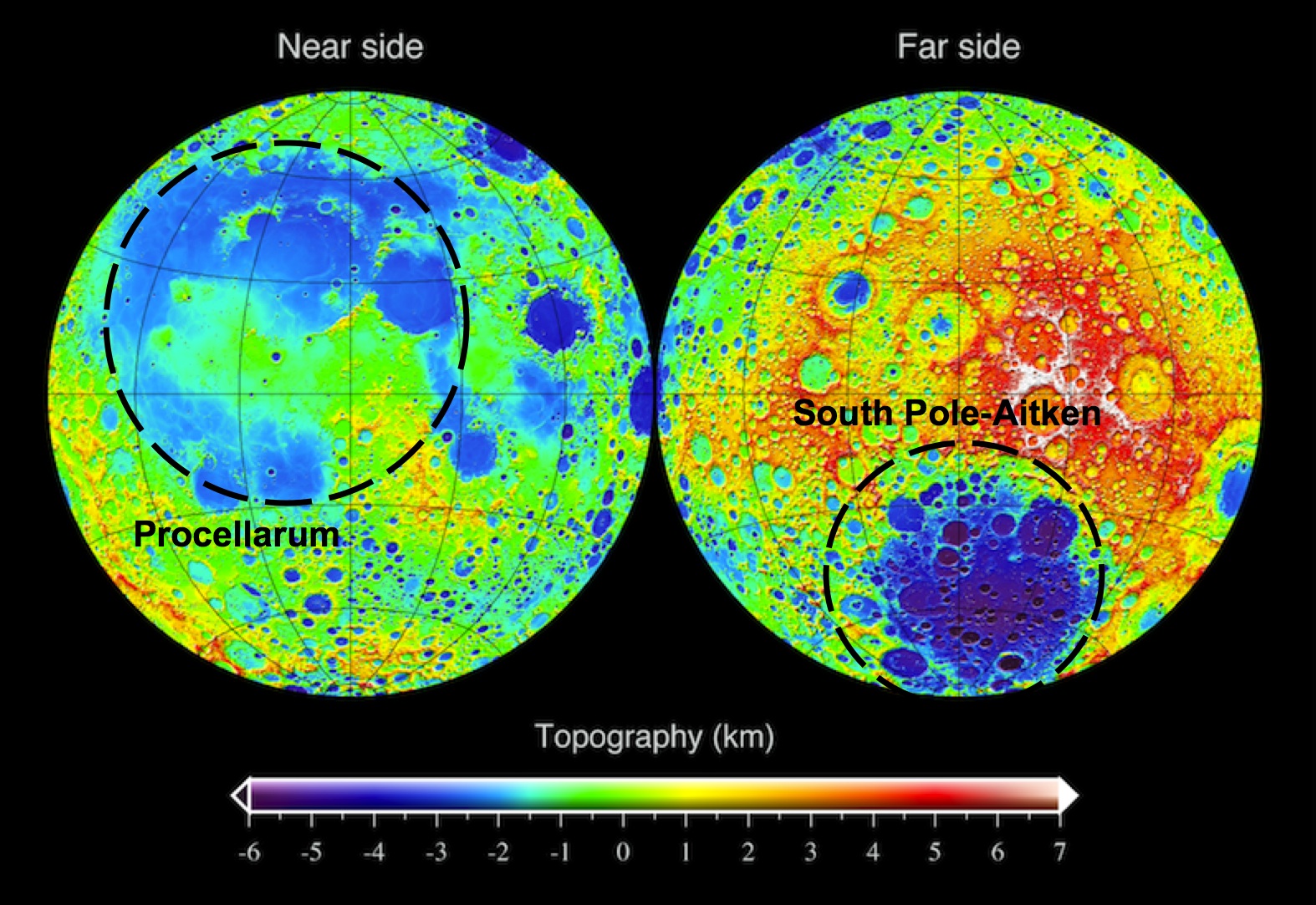
LRO topographic map of the Moon, showing the approximate outline of the "Procellarum" basin on the near side (left) and the South Pole-Aitken basin on the far side (right). One's real, the other isn't.
Yet doubts persisted.  In 1985, Peter Schultz and I suggested that the quasi-concentric arrangements mapped by Whitaker, were related to the Imbrium basin (not to an earlier, underlying mega-basin) on the basis of the ring pattern of this putative feature.  We also pointed out that the patterns of rock compositions supposedly explained by a Procellarum basin were not consistent everywhere, at least casting doubt on the predictive power of the basin’s presence.  The 1994 Clementine mission gave us our first global topographic map of the Moon.  Interestingly, that map dramatically revealed the presence of a circular mega-basin on the far side of the Moon – the enormous 2600 km-diameter South Pole-Aitken basin.  The Procellarum region was also shown to be a low region, but it is not circular (more horseshoe-shaped) and is not as clearly defined as Whitaker’s ring structure suggested.  The stock in the existence of Procellarum basin declined.

But some ideas in lunar science never really go away.  Since that time, several attempts have been made to resurrect the basin.  The latest effort, just published in Nature Geoscience, comes from mineralogical mapping data obtained from the Japanese Kaguya (SELENE) mission.  The authors of this study claim that orthopyroxene (a magnesium-silicate mineral) is distributed on the Moon in association with its largest basins – South Pole-Aitken and Imbrium.  However, in addition to those occurrences, additional outcrops occur in the highlands adjacent to Oceanus Procellarum.  Therefore, these rocks were made during the slow cooling of an enormous impact melt sheet created by the impact which formed the Procellarum basin.

The logic here seems weak.  It has not been established that orthopyroxene only forms from the slow cooling of an impact melt sheet.  When this mineral occurs with the most abundant mineral of the lunar highlands (plagioclase), it makes up a rock type called norite.  Norite is very abundant on the Moon.  It is the dominant rock type at the Apollo 14, 15 and 17 landing sites and occurs elsewhere on the Moon in quantity.  It is particularly prevalent around the edges of the Imbrium basin and one could argue that norite is a characteristic of that basin and the presence of Procellarum basin to explain its occurrence is unnecessary.  Likewise, the existence here of a large differentiated impact melt sheet is inferred from analogy to a terrestrial example, the Sudbury igneous complex, but even in this case, the impact origin of the terrestrial igneous body is not universally accepted.

Evidence for the existence of Procellarum basin must be sought in its topography.  The clarity and preservation of the far side’s South Pole-Aitken basin in the topographic data is surprising.  This feature is one of the oldest on the Moon, yet it preserves relief of over 12 km (the depth one would expect of a fresh feature).  One might expect such an old feature to be indistinct at best, making the discovery of its large relief one of the surprises of the Clementine mission.  At the same time, Procellarum is a vast irregular depression averaging less than 3-4 km deep; its lack of topographic expression is more in line with what one might expect for the oldest basin on the Moon.  However, unlike all other lunar basins, a topographic bulge 2-3 km high occurs near the center of this feature (near the crater Copernicus).  No other basin on the Moon (or on any other planet) contains interior topography higher than the elevation of its topographic rim; at SPA, all of the terrain within the 2600 km diameter rim crest is lower than its rim.  The unusual relation of a bulge within Procellarum does not support the concept that it is an impact basin.  It seems more likely that it is either a feature of internal origin (possibly related to early melting episodes) or a coalescence of several overlapping impact craters and basins.

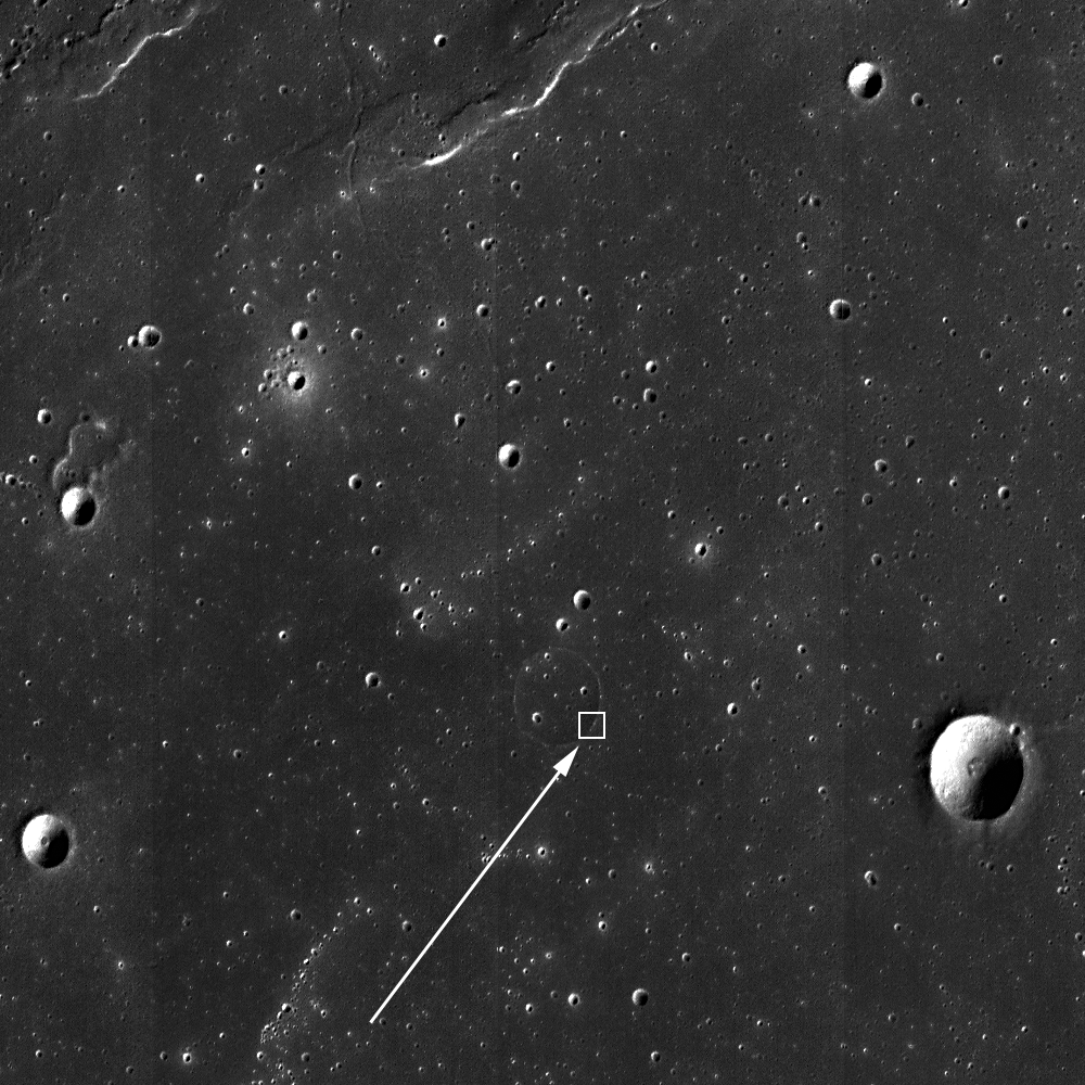
The elliptical South Pole-Aitken (SPA) basin, mostly on the Moon's farside though it's mountainous outer ring encompasses the the nearside's polar south and the Moon's lowest elevations. The oldest and largest of the Moon's definitively identified impact basins, recent studies appear to have pushed it's formation back beyond 4.1 billion years ago, within less than 500 million years after the formation of Earth and Moon [NASA/GSFC/LOLA].
As we search for the truth, Procellarum basin may well crop up again.  But for today and contrary to the current space press, the new results do not uniquely point to the existence of a large basin here.  In fact, the observations tend to support previous ideas that it is the smaller, overlying Imbrium basin that is associated with a large regional ejecta blanket of roughly noritic composition.

Originally published at his Smithsonian Air & Space blog The Once and Future Moon, Dr. Spudis is a senior staff scientist at the Lunar and Planetary Institute. The opinions expressed are those of the author and are better informed than average.

Thursday, November 1, 2012

Scours and Ejecta near Jules Verne Y

A topographic depression is mantled by impact debris (31.4°S; 145.0°E). An 800 meter-wide field of view from LROC Narrow Angle Camera (NAC) frame M130700036R, illumination is from the east, angle of incidence 73.63° at 55 centimeters resolution (in the original), from 53.74 kilometers [NASA/GSFC/Arizona State University].
James Ashley
LROC News System

The extreme energy of ground-hugging debris surges emanating from impact events often results in a distinctive V-shaped surface expression where the deposits are relatively fresh. Here we see such striations oriented with their apices pointing toward a fresh, unnamed impact crater just northwest of Jules Verne Y in the farside Highlands. The Featured Image highlights an area where this effect, which results from low-angle secondary impacts of ejected debris, seems to have been accentuated by local topography.

A wider view of NAC frame M130700036R. Image field of view is approximately 5 km in width [NASA/GSFC/Arizona State University].
A wider field of view from the same NAC frame gives increased context to the area highlighted in the LROC Featured Image.

Enlarging this LROC Wide Angle Camera (WAC) mosaic will permit inspection of scours radiating from the fresh impact just northwest of Jules Verne Y. Image with is approximately 950 km [NASA/GSFC/Arizona State University].
Even in the 100 m/pixel WAC mosaic, scours from interacting ejecta and terrain are clearly visible. To the northeast of the fresh crater can be seen additional scours that are oriented in a southwesterly to northeasterly direction, away from the impact site. Click HERE for the full NAC frame. Other examples of recent deposits can be found in the LROC Featured Images, In the Wake of Giordano Bruno, Ejecta Starburst, and Action Shot.

Additional perspective from a simulated perspective 170 km over this under-appreciated area of the Moon's farside highlands. ILIADS application, NASA Lunar Mapping and Modeling Project (LMMP), LROC WAC mosaic over LRO LOLA laser altimetry-based digital terrain model [NASA/GSFC/Arizona State University].