Showing posts with label NASA. Show all posts

Wednesday, February 18, 2015

Hell Q

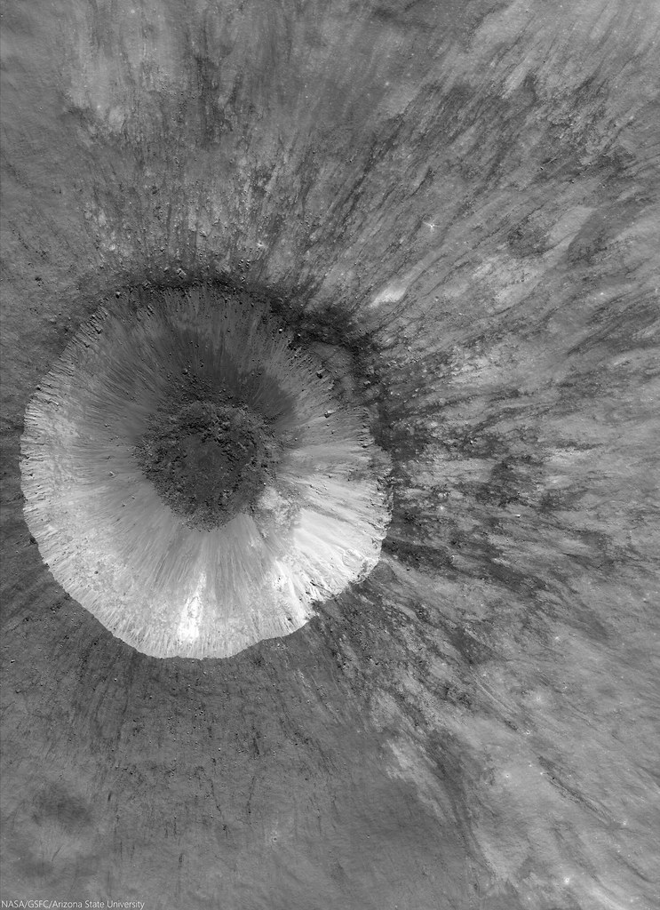
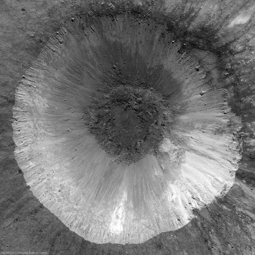
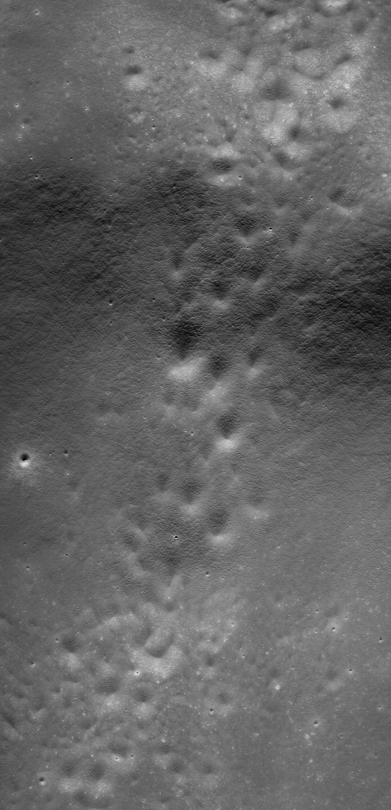
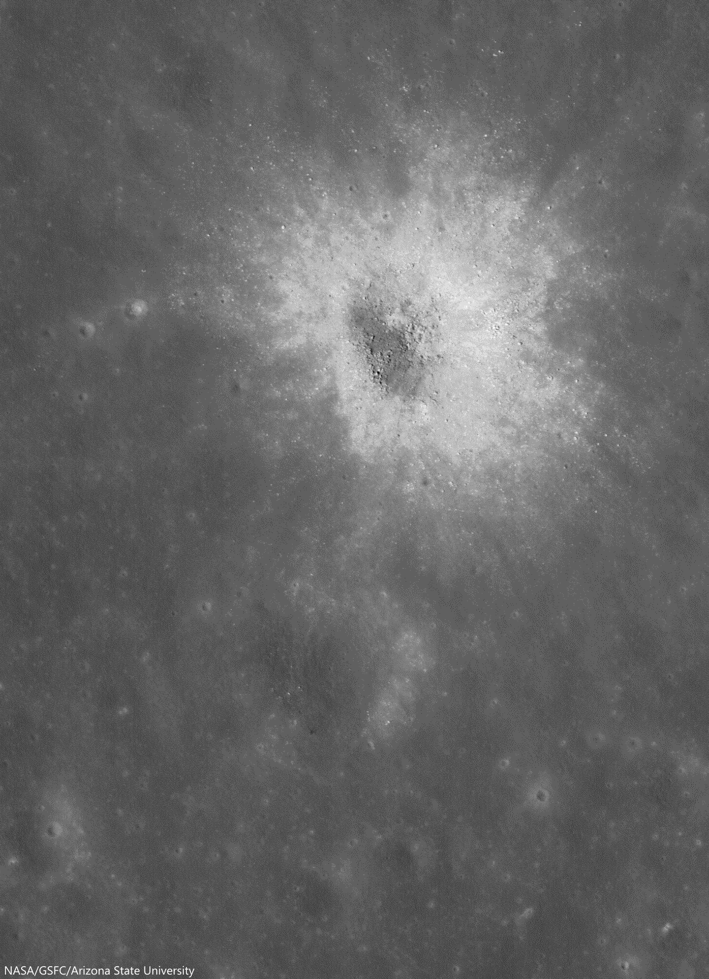
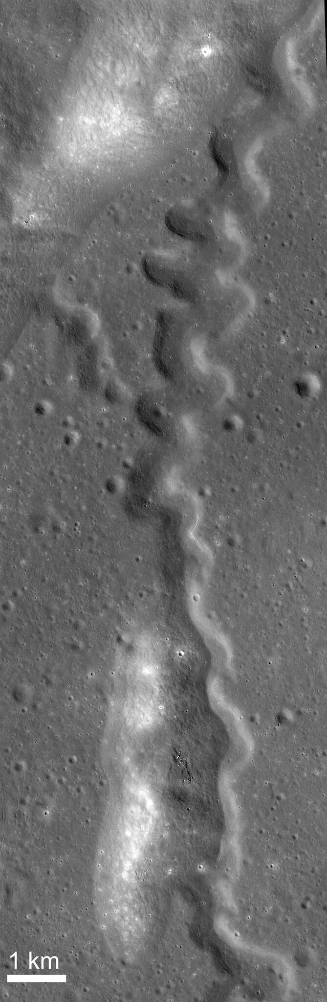
LROC NAC mosaic M1164853645RL, LRO orbit 23561, September 8, 2014; spacecraft and cameras slewed 3° from nadir, 33.17° angle of incidence, 71 cm resolution from 68.29 km over 33.07°S, 355.72°E [NASA/GSFC/Arizona State University].
Hell Q (3.75 km; 33°S, 355.53°E) seems younger than Tycho, standing out as it does in the nearside Southern Highlands northeast of the more famous astrobleme. 

There seems little doubt the effect of the larger, far more widespread blast zone from Tycho changed the face of this contemporary but pre-existing smaller crater. The chevron effect left grooves untouched down stream and tore away a chunk of the northeast rim, morphologies apparently perpendicular to a straight line drawn southwest to the more spectacular, 109 million year-old Tycho.

View full resolution views, of a variety of sizes, HERE.

Tuesday, November 18, 2014

Mottled mound at Firsov

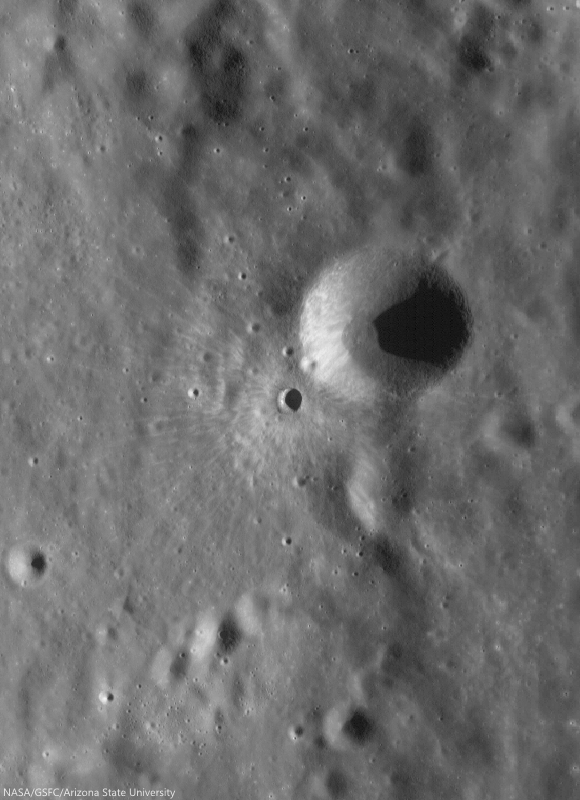
Low-angle incidence view of a curious mound on the floor of Firsov crater (51 km; 4.204°N, 112.697°E). 2.2 km field of view from LROC NAC observation M187506567R [NASA/GSFC/Arizona State University].
Hiroyuki Sato
LROC News System

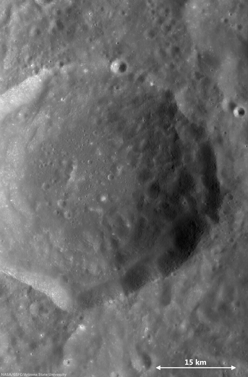
Firsov is a 51-km diameter crater located in the farside highlands, approximately 240 km east of King crater. The depth of Firsov's floor from the rim crest is an impressive 4.5 km (that’s 2.5 times the depth of the Grand Canyon in Arizona).

The bright (highly reflective) mound on the crater floor is about 200 meters in height, and 2.5 km in diameter, and really catches your eye. The central portion of the crater floor is relatively flat, suggesting that it at least partially consists of a long-solidified pool of impact-melt; the mound is located within this melt pond deposit.

46 km-wide field of view showing  the high-reflectance mound feature, near center of FriFirsovater, from LROC WAC monochrome (643 nm) observation M176892340CE, LRO orbit 11204, November 25, 2011; 62.51 incidence, resolution 58.62 meters from 43.41 km [NASA/GSFC/Arizona State University].
A number of previous Featured Image posts explored the origins of mounds occurring inside impact craters. Hypotheses include volcanic eruptions, impact debris, and the squeeze-ups of impact melt.

Today's Featured Image highlights the degradation of these mounds, instead of their origin. The low-incidence angle of the top image (~9°) highlights differences in albedo on the mound top, what causes these bright patches?

Perhaps, as the mound surface degrades over time, the high-reflectance materials are exposed unevenly, for example, due to a bumpy surface morphology, where local, topographically high portions are exposed faster and newly exposed material is immature (and thus brighter).

Alternatively, the mound may be constructed from non-uniform materials and/or compositions that exhibit a range of reflectivities. However, scientists believe that during impacts any compositional differences within the target are homogenized in melt deposits. This mound would be a great place to examine that hypothesis.

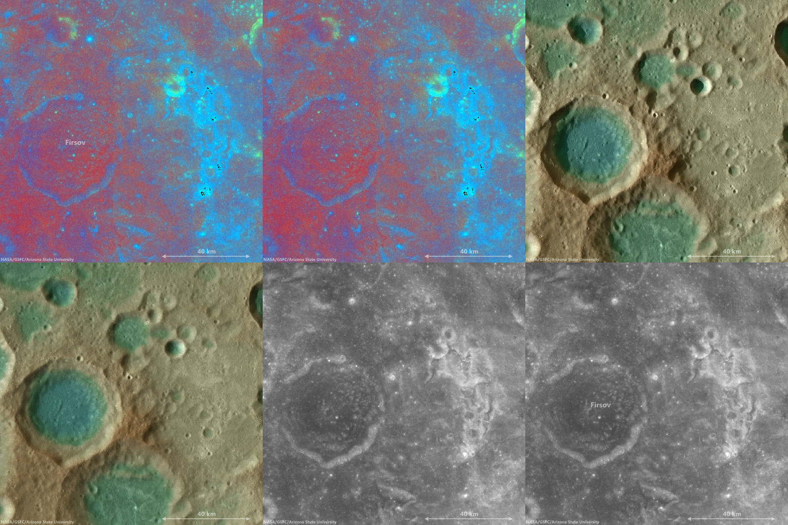
The bright mound southeast of center on the floor of Firsov is not the only albedo "anomaly" in the vicinity of Firsov crater. This cycle of overlapping fields of view, juxtapositioning data ranging from LROC WAC-derived elevation models to Clementine UV-VIS color ratio maps from 1994, brings into stark relief the unnamed Copernican era crater northeast of Firsov, and also the dramatic patch of albedo swirls coincident with a locally intense crustal magnetism, photographed from orbit by the crew of Apollo 10. It seems distant and detached, but still these swirls are likely associated with the widely-scattered swirl fields farther to the west at Mare Marginis, on the opposite side of the Moon from the energetic basin-forming impact that formed Mare Orientale 3.1 billion years ago [NASA/GSFC/Arizona State University].
View full-window, HERE.

Related Posts:
Shiny Mound
Kagami-mochi on the Moon!
Pancakes in a melt pond
Donut Holes
The Domes of Stevinus Crater
That's a Relief

Friday, November 7, 2014

Exploring the lunar subsurface

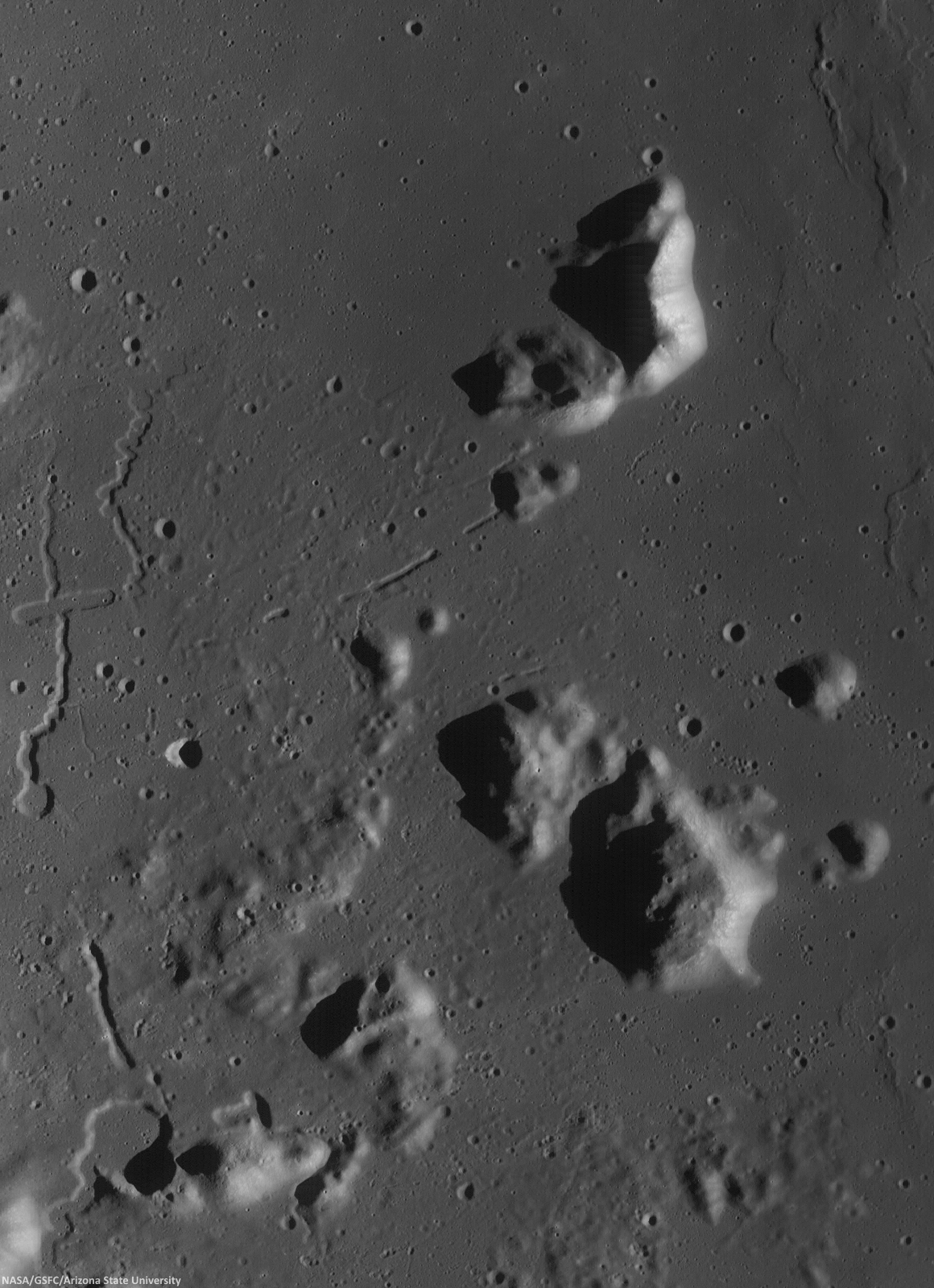
Two collapsed segments of a lava tube run from the southwest to the northeast, in the Rimae Prinz-Harbinger mountain region of Oceanus Procellarum (27.46°N, 318.33°E). These collapsed segments may provide access to the subsurface, which has never been directly sampled. The average width of the collapsed segments is ~650 meters. The lava tube is ~50 meters deep, seen in this 7 km-wide field of view from a mosaic of unreleased 2014 LROC NAC observation M1165080128 (L&R) [NASA/GSFC/Arizona State University].
H. Meyer
LROC News System

A lava tube is a volcanic conduit through which lava travels beneath the hardened crust of a lava flow. The presence of lava tubes on the Moon and beyond are inferred based on observations of terrestrial lava tubes, such as those found in Hawaii. Oftentimes, a rille suddenly disappears only to reappear a short distance away.

These are called discontinuous rilles and are thought to be areas where a lava tube collapsed. Collapsed lava tube segments may provide access to the subsurface, which is exciting as a possible site to collect rock samples that remain unaltered due to surface weathering (radiation, thermal cycling, micrometeorite bombardment).

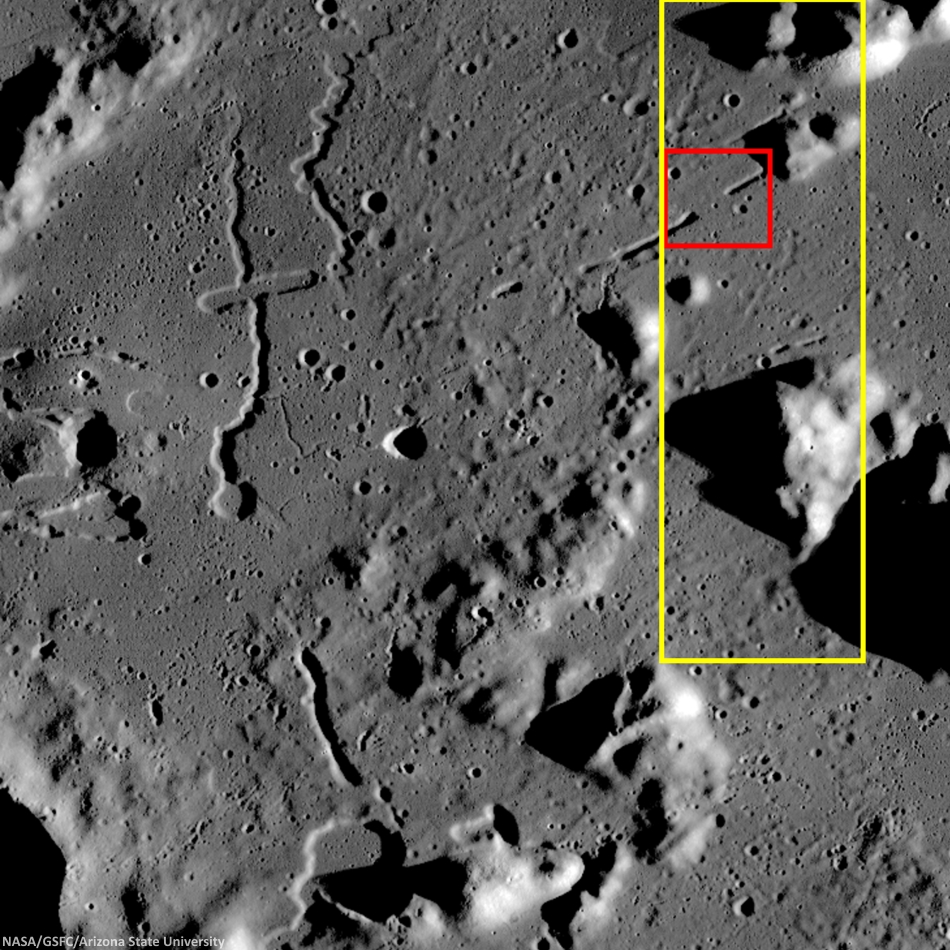
Slightly differing, slightly lower resolution, 11.5 x 15.9 km field of view of the area of interest from a mosaic of LROC Narrow Angle Camera (NAC) observation M1152143995RL, LRO orbit 21776, April 14, 2014; resolution averages 1.33 meters per pixel, incidence angle 48.9° from 132.14 km over 26.86°N, 318.11°E. View the original 8706 x 12008 and an assortment of other sizes HERE [NASA/GSFC/Arizona State University].
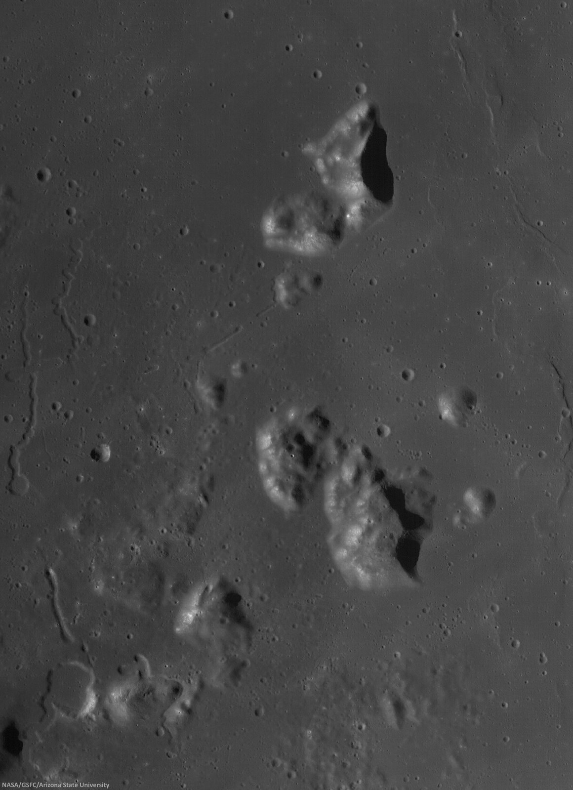
Sunrise over Mons Harbinger. 65 km-wide field of view from mosaic of three LROC Wide Angle Camera (WAC) monochrome (604 nm) observations, swept up during three sequential orbital passes, December 7, 2011,  from 43 km; resolution 58 meters per pixel, incidence 77° [NASA/GSFC/Arizona State University].
Context for LROC Featured Image released November 6, 2014, field of view in red, full field swept up in LROC NAC observations M1152143995R & L in yellow. LROC WAC mosaic [NASA/GSFC/Arizona State University].
The lava tube from the LROC Featured Image released November 5, 2014 is located to the west of Montes Harbinger, a large kipuka in Oceanus Procellarum, and to the east of the Rimae Prinz region.

The Rimae Prinz region displays exquisite sinuous rilles as well as other elongate depressions, indicating that there could be other lava tubes in the area.
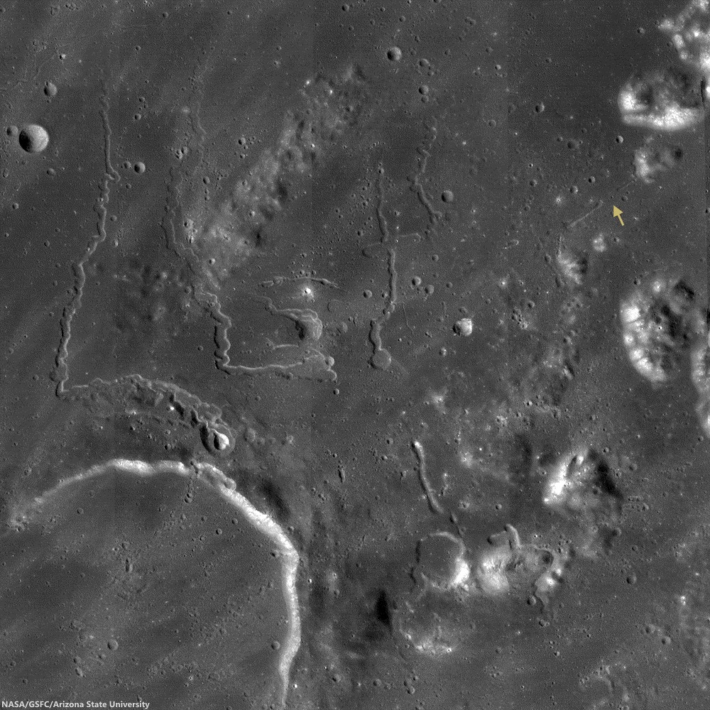
The Prinz, Rimae Prinz and Vera vent region, east of Aristarchus Plateau. The area of interest is marked with a yellow arrow, upper right in this roughly 120 km square field of view from the LROC WAC 100m global mosaic. the Vera vent 'cobra head' of Rima Prinz I rille (on the north-northeast rim of basalt-inundated Prinz crater, at lower left), is the subject of intense study (see HERE). [NASA/GSFC/Arizona State University].
The entire region, pictured above, is of interest for exploration for several reasons. The diversity of volcanic landforms in the area can tell scientists much about the volcanic history of the Moon. By collecting samples from the surface and subsurface in this region and by careful mapping on-site, scientists can better characterize the diverse basaltic lava flows in terms of both age and composition, which also helps us understand the timing and evolution of lunar volcanism and possible heterogeneities in the lunar mantle. Any time a sample is taken from a site on the Moon and age-dated, it can also be used to calibrate crater densities that are currently used to remotely age-date surfaces in the absence of direct sampling (both on the Moon and other planets).

Lava tubes are of particular interest in terms of human exploration because they are not only scientifically valuable, but they might also provide shielding from the radiation that poses a hazard to future explorers. Furthermore, the region surrounding the lava tube from this Featured Image also hosts large pyroclastic deposits, which are a potential in situ resource that will be critical to sustaining a human presence on the Moon.

Scientists and engineers are looking into the possibility of using the natural structure of the lava tube and associated resources (ISRU) to our advantage to construct habitats for explorers.

Explore the full NAC mosaic here! How many features of interest do you see?

Rimae Prinze Region - Constellation ROI
Discontiguous Rilles

Addendum: Under mid to late afternoon sunlight, another LROC WAC mosaic, swept up under conditions remarkably similar in scale with the third image from above, from the same period of low altitude opportunities the LRO mission afforded during orbital maneuvers in the second half of 2011. Differing sun-moon-spacecraft phase angles allows for an excellent comparison. This particular mosaic was also assembled from LROC WAC observations, but five months earlier, and from three sequential orbital passes, at 43 km altitude. The resolution is 59 meters, incidence angle 64° [NASA/GSFC/Arizona State University].

Thursday, September 4, 2014

Secondary scatter over Haret C and the SPA interior

A stream of secondary craters crosses the rim of Haret C (28.47 km; 57.6°S, 186.3°E), stretching from the northeast exterior, southeast into the interior of the crater, deep within the South Pole-Aitken impact basin. 6.52 km-wide field of view from LROC NAC mosaic M1163623161LR, LRO orbit 23388, August 25, 2014; 56.75° incidence, resolution 68 cm from 63.63 km over 57.6°S, 185.26°E [NASA/GSFC/Arizona State University].
H. Meyer
LROC News System

Closely clustered or overlapping craters of similar size and morphology are likely secondary craters.

Secondary craters form when an impactor hits the surface (forming the primary crater) and throws out blocks of material that proceed to form their own craters (secondaries) as they hit the surface.

Sometimes, secondary craters can be difficult to identify if they do not occur in groups. Because craters are used to estimate the age of a surface (a process called crater counting), it is important that scientists are able to identify secondary craters.

Thankfully, in the case of Haret C, the secondary craters stand out from primary craters due to their proximity to each other. Random impacts typically do not form clusters like those draped over Haret C (28.47 km; 57.6°S, 186.3°E) .

A quick look at Haret C made possible by the international burst of lunar exploration briefly inspired by interest in the run-up to the Constellation program. The crater chain is easy enough to see in the medium resolution global albedo mosaic swept up from Chang'e-2. And the basics of the ranges and elevations of the region are displayed using the LROC Quickmap service.
Within high resolution images, smaller craters are used for crater counting. However, secondary craters become more common at smaller diameters introducing a problem for crater counters if the secondaries cannot be distinguished from primary craters. Secondaries counted as primaries result in higher crater counts per unit area, which in turn result in age estimates that are older than the true age of the surface.

Haret C does not dominate, but it is easy to pick out near the center of this HDTV still (larger view HERE) from Japan's lunar orbiter Kaguya (SELENE-1) in 2008. There are two other stills where Haret C and its crater chain are visible in context with central South Pole-Aitken basin and it's larger neighbors Bose (92.5 km; 53.95°S, 190.63°E) and Bhabha (70.52 km; 55.49°S, 194.69°E), HERE and HERE [JAXA/NHK/SELENE].
A key science goal is coming to a better understanding of the morphology or abundance of secondaries relative to primary craters so that more accurate age estimates can be made for smaller, younger terrains: especially important for panning at the scale of the NAC images for future missions to the Moon.

Seven minutes of video from GRAIL-A (Ebb) during orbit 1902 in 2012. Using the student-directed Forward MoonKAM video camera we can close in on the secondary crater chain at Haret C looking north from a perspective beginning at 30 km rising to 41 km over the surface at the end of the sequence. Starting in the polar latitudes of the southern farside the compressed view quickly passes up over the enigmatic interior of South Pole-Aitken basin, over Antoniadi (137.91 km; 69.3°S, 186.94°E, home of the Moon's lowest elevation) north 22° following the meridian that crater shares with Haret C [NASA/JPL/UCSD/SRSC].
Explore the full-width NAC mosaic HERE. Do you see any primary craters in the mix?

Related Posts:

Wednesday, August 27, 2014

Pit craters in NAC DTM topography

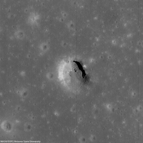
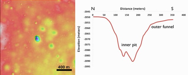
The crisp morphology of the central Mare Fecunditatis pit (white arrow) stands out in elevation data and suggests a relatively young age. This pit is about 200-m in length and 45 m deep. Image width is 5 km; north is up. Color shaded-relief created from NAC DTM FecundPit; higher elevations shown in red and lower elevations in blue and purple [NASA/GSFC/Arizona State University].
J. Stopar
LROC News System

Eight mare pits have been discovered so far on the Moon, five of which preserve void spaces (sublunarean voids) beneath overhanging mare layers. The pit featured above, located in central Mare Fecunditatis (0.917°S, 48.66°E), however, does not have an obvious void space. The pit is almost 200 m wide and about 45 m deep.

The central Mare Fecunditatis pit has a concave shape, with gentler slopes (outer funnel) near the upper mare surface, and a steeper-walled inner pit (see image below). Variations in wall slopes are consistent with a fine-grained, particulate layer (regolith) overlying more coherent mare layers. The steep inner pit suggests collapse into a small void space. The debris in the pit floor consists of both regolith and mare blocks from the upper layers.

Pit crater (0.92°S, 48.66°E) near Messier B, now generally designated the Central Fecunditatis pit crater to distinguish it for a more recently discovered skylight in southwest Fecunditatis. LRO's longevity has enabled repeated narrow angle photography of selected areas on the Moon, allowing for the team at Arizona State University to build up very high-resolution, NAC-based digital terrain models. 540 meter field of view from LROC NAC observation M1105602888R, LRO orbit 15232, October 23, 2012; 35.18° incidence angle, resolution 93 cm from 108.28 km over 0.92°S, 49°E [NASA/GSFC/Arizona State University]
Left: color shaded-relief of NAC-derived elevation data. Reds are higher elevations, purple lower elevations. Right: elevation profile of a north-to-south cross-section through the pit. The inner pit has steep walls, while slopes near the mare surface (outer funnel) are more gentle [NASA/GSFC/Arizona State University].
The lack of raised rim or ejecta around the pit, indicates that it most likely formed through collapse, rather than as an impact event. While this pit is not located near any obvious tectonic features or volcanic constructs, the collapse may have occurred into part of an old lava tube. The crispness of the pit morphology, suggests that the collapse occurred relatively recently (geologically speaking, at least), perhaps much less than 1 billion years ago. Pits are among some of the youngest landforms on the Moon, and are similar in age to many fresh craters (such as Tycho, Copernicus, or Aristarchus).

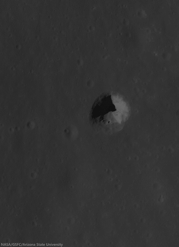
More recently identified pit crater in southwest Mare Fecunditatis (6.752°S, 42.76°E), discovered during Wagner and Robinson survey. A 325 meter-wide field of view from LROC NAC M167926438R, LRO orbit 9881, August 14, 2011; 42.25° incidence angle, resolution 56 cm from 26.73 km over 6.71°S, 42.72°E [NASA/GSFC/Arizona State University].
Read More About Lunar Pits:  Lunar pits were recently featured in the news and the focus of a scientific publication ("Distribution, formation mechanisms, and significance of lunar pits," Robert V. Wagner and Mark S. Robinson, Icarus, July 2014; pg. 52-60).

The pits are of particular interest to lunar scientists because they could offer access to subsurface materials, making them important targets for further research and exploration.

Explore the pit in the full-resolution LROC NAC observation HERE.

More Pits:

Tuesday, August 12, 2014

Complimentary craters, south of Maclear

South of Maclear in northwest Mare Tranquillitatis, two complimentary craters of very similar location, size and origin, but additionally of widely different ages. The relentless bombardment of small debris "gardens" the lunar surface at an average rate of 3 mm every 2 million years. In addition to the nearly billion year long cycle of cosmic ray dark-reddening, "space weathering" ages, or "optically matures" the lunar surface at a predictable rate, adding to crater counts and super-positioning another useful tool to the craft of dating lunar features from a distance. LROC NAC observation M131515002R, LRO orbit 4515, June 18, 2010; 79.75° sunrise incidence angle, resolution 85 cm from 40.68 km over 9.09°N, 20.14°E [NASA/GSFC/Arizona State University].
Raquel Nuno
LROC News System

There are several distinguishing properties of craters that help lunar scientists determine their ages. As craters get older their appearance changes through exposure to solar wind bombardment and other impacts (collectively called space weathering), and even gravity has an effect.

Effects of the solar wind lower the reflectance of the surface; so regolith (soil) that was excavated by recent impacts has higher reflectance than the background surface, this is why small young craters have visible crater rays. New impacts pulverize rocks that were ejected during the formation of an older crater and disturb the shape by causing moonquakes. Also, gravity works to alter the shape of a crater by pulling material down its walls in a process called slumping, this causes craters to have a smoother appearance.

1.69 km field of view from LROC NAC Commissioning observation M106748283R, LRO orbit 873, September 5, 2009; 29.84 low-angle incidence, resolution 1.17 meters from 133.64 km over 9.82°N, 20.15°E [NASA/GSFC/Arizona State University].
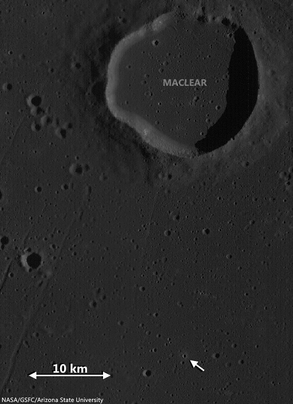
Today's Featured Image showcases two similarly sized adjacent craters (each ~500 m in diameter) located in Mare Tranquillitatis (see WAC context image below) with very different appearances. The area surrounding the top crater is littered with boulders in all directions. Wheras the more southerly crater has only a few rocks near its rim. Where did the boulders come from in the first place? And did the lower crater originally have boulders?

Locating two co-located 500 meter "complimentary craters" (arrow) good for comparing rates of general space weathering, in west-northwest Mare Tranquillitatis. LROC Wide Angle Camera (WAC) monochrome (566 nm) observation M131514941C, captured simultaneous with the NAC observation opportunity shown in the Featured Image at the top of this post. LRO orbit 4515, June 18, 2010; 79.75° incidence, resolution 57.7 meters from 40.72 km over 10.17°N, 20.14°E [NASA/GSFC/Arizona State University].
Since the mare basalt formed from layers of lava that hardened into solid rock, it is likely the boulders are coherent fragments of those thick layers (a few to tens of meters thick) that were broken up and ejected during the impact event. Since these two craters are so close and both formed in the mare it is very likely that the lower crater also had a large grouping of boulders in its ejecta field. The dissimilarity between these two craters is most likely due to age difference. Over time (perhaps a couple of billion years) the original boulders around the lower crater were slowly ground down by micro-meteorite bombardment - think of this process as cosmic sand-blasting! The boulders around the younger crater (top) have not had time to be pulverized by other impacts, but stick around for a billion years and you can watch these boulders slowly disappear!

Explore the full resolution NAC HERE.

Related Posts:

Thursday, August 7, 2014

Dark Halo "Patch" west of Neper D

A roughly 470 meter wide, 560 meter long, unusually large and cohesive fan of dark halo ejecta from an unnamed but freshly prominent crater in the Neper group, southwest of Mare Marginis. 1020 meter-wide field of view from LROC NAC observation M1136029635L, LRO orbit 19510, October 10, 2013; 32.5° incidence, resolution 1.17 meters from 116.96 km over 8.73°N, 79.36°E [NASA/GSFC/Arizona State University].
Hiroyuki Sato
LROC News System

Today's Featured Image highlights an odd shape, or texture in impact ejecta. An unnamed, approximately 600 meter-wide fresh crater on a relatively high, far older crater rim, between Mare Marginis and Mare Undarum (9.5122°N, 79.40242°E) hosts teardrop-shaped low reflectance patches in its ejecta, northwest of the crater,

The larger teardrop patch in the opening picture has a sharp boundary along its western edge, perhaps implying a partially elevated surface relative to the surrounding high-reflectance ejecta.

4 km-wide field of view from LROC NAC observation M1136029635L, October 10, 2013 [NASA/GSFC/Arizona State University].
Note the faint high-reflectance ray overlying this patch, indicating that the low reflectance patch was emplaced before the completion of the impact event. Similar dark patches that are smaller and less pronounced are found at the top of the opening image.

How were these peculiar dark patches formed? If these patches are elevated, they could represent preexisting flat dark mounds that were swept by the saltating ejecta materials. Or the excavation of low-reflectance materials by the impact could have been thrown out in one direction and resulting in this unusual patch of ground. If, on the other hand, the patches are topographic lows rather than elevated, these depressions could have simply been shielded as the ejecta passed overhead. It is also possible that the topography of the rim controlled the direction of the outthrown ejecta such that there were "no ejecta" zones that resulted in the dark patches.

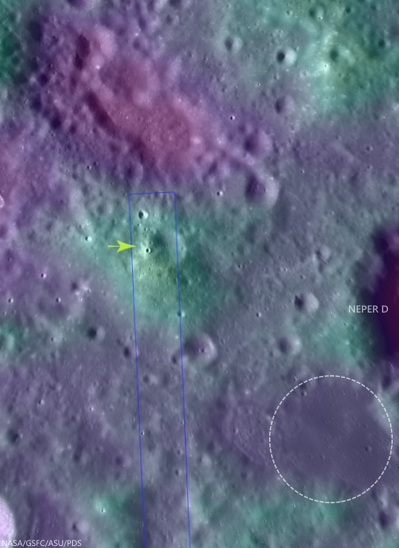
Fifty kilometer-wide field of view of the complex terrain southwest of Mare Marginis, west of Neper and Neper D. The unusually cohesive "fan" of apparent dark halo material from the unnamed relatively fresh 600 meter crater is marked at 9.5122°N, 79.40242°E (arrow) and may indicate the presence of now-buried optically mature material widely distributed in the area. The circle southwest of Neper D is a patch of isolated mare material bright in Clementine iron oxide surveys, often indicative of cryptomare.  Crater counts might eventually determine whether its age and whether or not this area is consistent with Mare Marginis or ejecta from the Crisium impact, or something much older. LROC WAC global 100 meter mosaic over LOLA laser altimetry [NASA/GSFC/ASU/USGS].
High resolution topography would really help unravel this mystery! NAC to the rescue! The LROC targeted this area for upcoming NAC stereo pairs from which meter-scale topography will be extracted. In a few months, we will post the topography and will see if we solved the mystery!

Explore this peculiar dark patch and surrounding terrain in the following full NAC frame, HERE.

Related Posts:

Tuesday, August 5, 2014

Fractures and boulders on the floor of De Forest

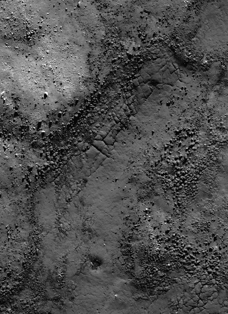
Fractured impact melt left the interior of De Forest crater (56.25 km; 76.94°S, 196.67°E) lined with boulders. 665 meter-wide field of view from LROC NAC observation M125650563L, 665 meter-wide field of view from LRO orbit 3650, April 11, 2010; 78.87° incidence angle, resolution 57 cm from 55.16 km over 77.1°S, 197.94°E [NASA/GSFC/Arizona State University].
Hiroyuki Sato
LROC News System

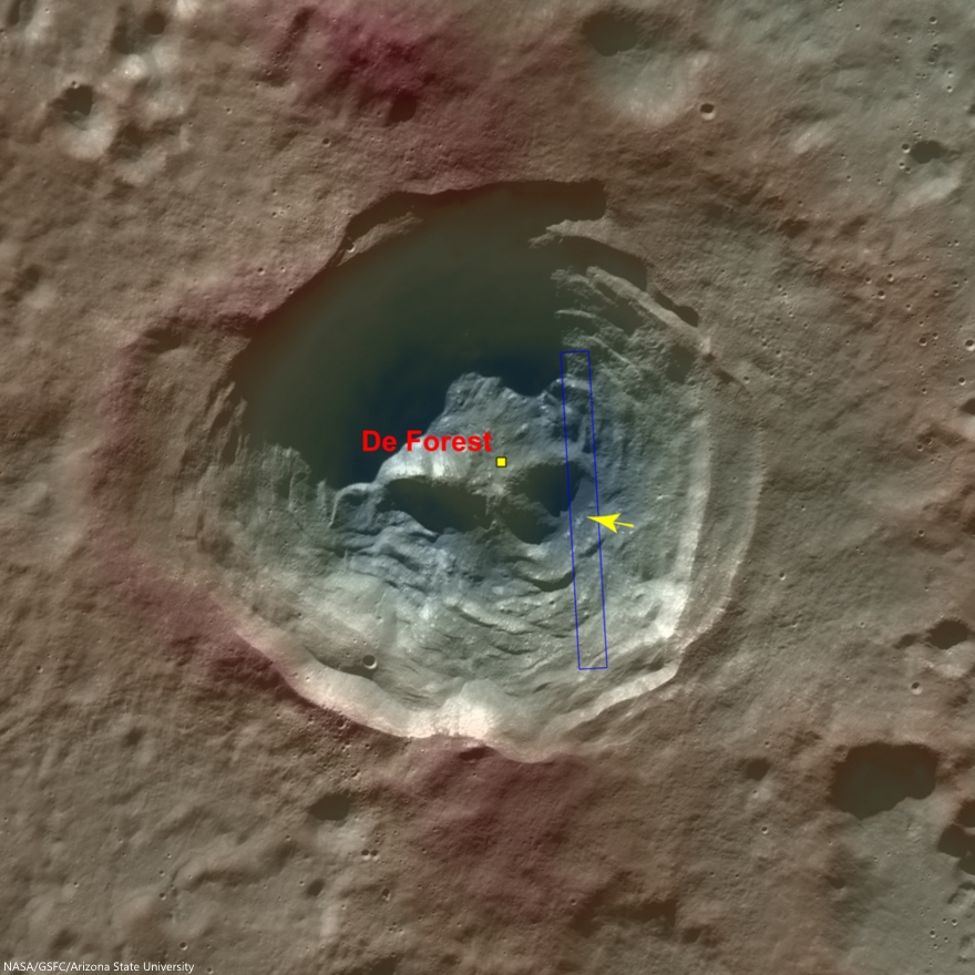
Today's Featured Image highlights a portion of the interior of De Forest crater (56.25 km; 76.94°S, 196.67°E), which is located inside the South Pole–Aitken basin.

The cavity of De Forest crater exhibits prominent terraces of collapsed materials surrounding the central peak (see context imagery following).

The topographic low, east of the central peak, was largely coated with hot impact melt which formed a hard crust as it cooled; a portion of this melt is seen in the opening image. 

Context view of De Forest crater (56.25 km; 76.94°S, 196.67°E) consisting of LROC WAC monochrome mosaic (100 m/pix) overlain with colorized WAC stereo DTM (GLD100, Scholten et al., 2012). View centered on 76.92°S, 197.51°E. Footprint of LROC NAC observation M125650563L, April 11, 2010, outlined in blue, source of high-resolution view of the area designated with a yellow arrow (LROC Featured Image released August 5, 2014) [NASA/GSFC/Arizona State University]. 
Much of the area of the opening image is covered by numerous boulders, some of which are up to approximately 15 meters across.

The smooth surface extending in lower-left to upper-right is impact melt that cooled to form solid rock, and is now fractured in regular patterns along the edge. Impact melt that was splashed on the crater's walls and its central peak formed a coating that quickly cooled to solid rock.

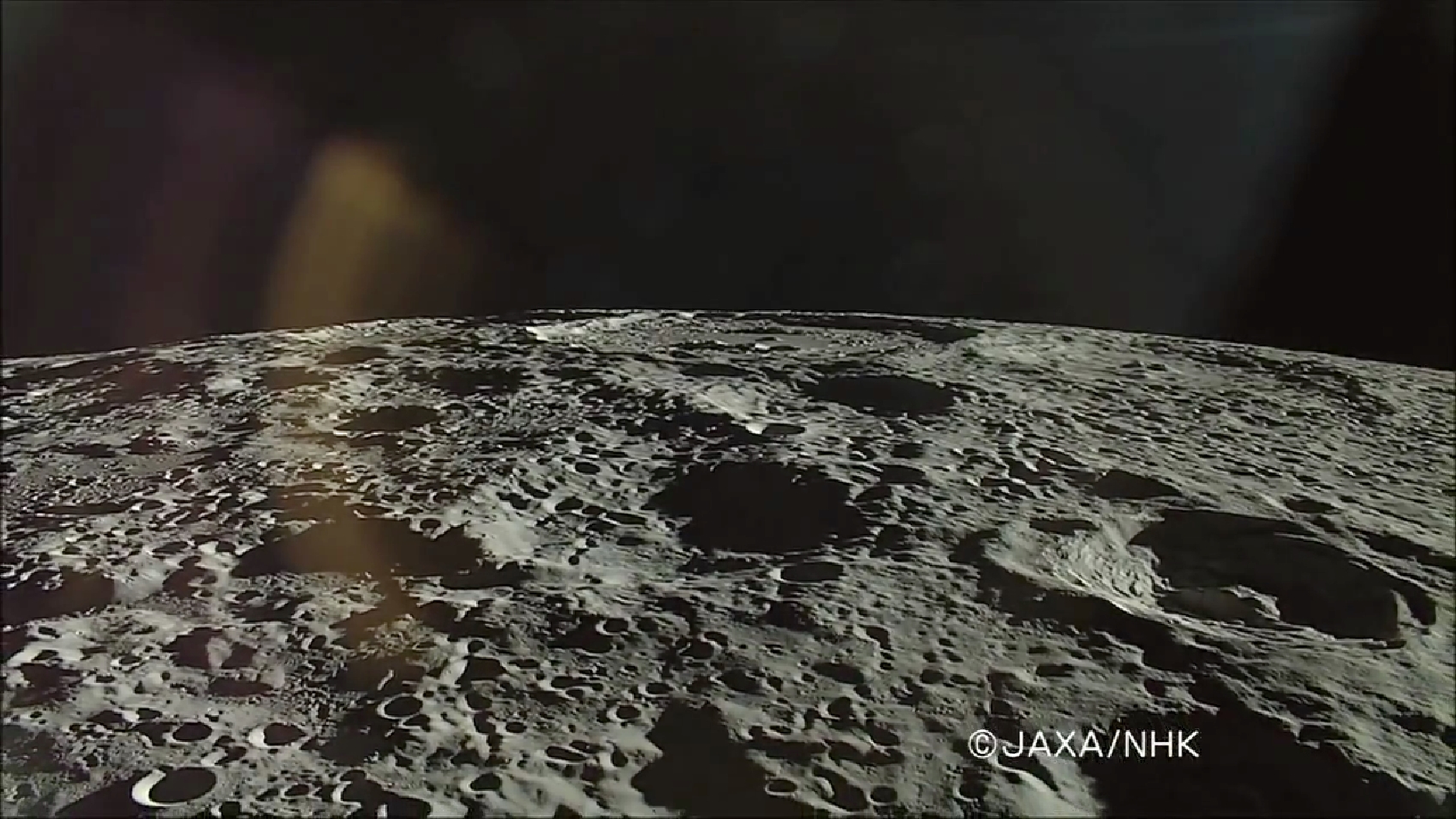
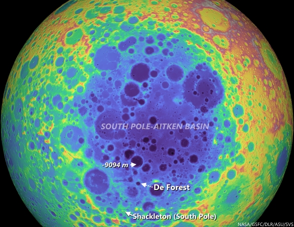
On the true "backside" of the Moon, De Forest (right) is situated well inside South Pole-Aitken impact basin, between Antoniadi (upper left, near horizon), host of the Moon's lowest elevation (-9094 meters) and Shackleton (not pictured), host of the Moon's south pole. HDTV still from Japan's lunar orbiter Kaguya (SELENE-1) in 2008 [JAXA/NHK/SELENE].
Later, it is likely that nearby moonquakes caused these brittle rock coatings to fracture, providing the source of boulders we now see on the lower reaches of the crater floor.

De Forest's position in the far south Farside is an area hosting Permanently Shadowed Regions (PSR's). The neutron detection experiment on-board LRO (LEND) has built up signatures consistent with cold-trapped volatiles, like water ice, in the vicinity. Image from Science Visualization Studio tour of SPA, larger image HERE [NASA/GSFC/Arizona State University/DLR/SVS]. 
As you can see in the following full NAC frame, an enormous number of similar boulders are found along the smooth melt deposits on the floor of De Forest crater. 

Explore this boulder-rich crater in the full NAC frame, HERE.

Related Posts:

Friday, August 1, 2014

A tortuous path in Posidonius

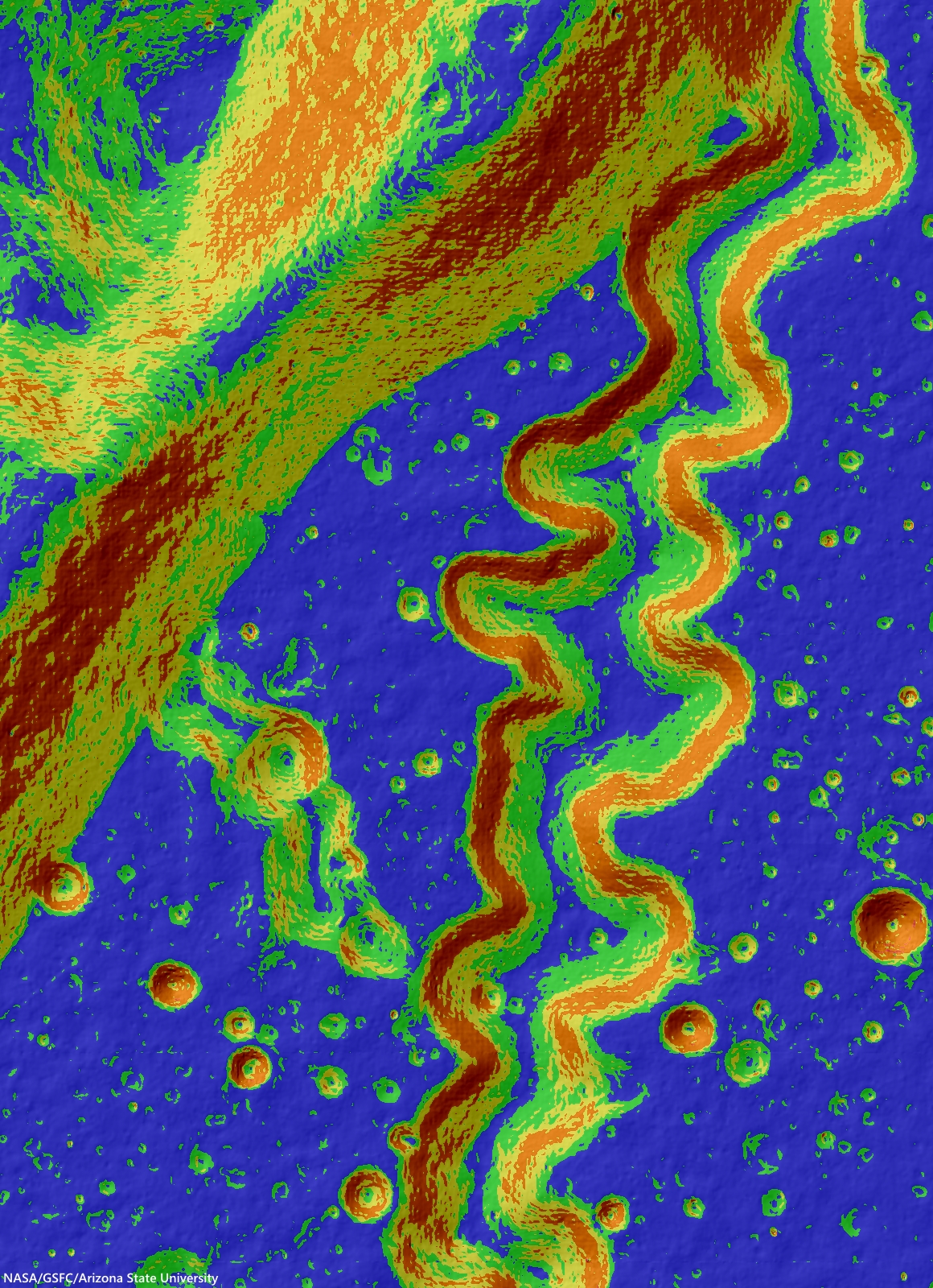
This may look like a work of abstract art, but in reality, it's for science! This colorful image is an LROC slope map of the northwestern portion of the floor of Posidonius crater. Warmer colors indicate steeper slopes, whereas cooler colors are shallower slopes. A rille winds its way across the floor and flows along a southerly course, diverging from its path along the crater rim. A tributary rille can be seen joining the main rille at the bottom center. Image width is approximately 5.5 km. North is up [NASA/GSFC/Arizona State University].
H. Meyer
LROC News System

Sinuous rilles, such as the one above, form through the flow of hot, turbulent lava.

Rilles can be found in many locations across the lunar surface and two very different mechanisms are generally thought to form them.

Mechanical erosion refers to the physical removal of material by the lava flow, similar to how rivers erode channels on Earth.

Alternately, some lavas are so hot that they partially melt the substrate, and deepen the channel through time. These processes on there own would both result in downcutting into the surface, but they were often simultaneously working to reshape the lunar surface.

Posidonius (95 km, 31.878°N, 29.991°E) exhibits several rilles of differing types, seen below (linear and sinuous).

The vicinity of the northwest quadrant of Posidonius (95 km, 31.878°N, 29.991°E) has to have been imaged at high-resolution from more than one angle to enable interferometric determinations and to create the LROC NAC-derived Digital Terrain Models. Above the same general vicinity was imaged with spacecraft (and camera) slewed 59.03° from orbital nadir. LROC NAC observation M1096379115L, LRO orbit 13941, July 8, 2012; 82.31° sunset incidence, resolution 4 meters, from 145.49 km over 32.37°N, 17.41°E [NASA/GSFC/Arizona State University].
Posidonius is a 95 km diameter crater on the northeastern margin of Mare Serenitatis. The floor of Posidonius exhibits a number of interesting geologic features. In the western portion of the floor, the sinuous rille from Today’s Featured Image winds its way through smooth plains that partially bury the crater wall.

LROC NAC M1098658474R, LRO orbit 14260, August 3, 2012; 53.15° incidence angle, resolution 1.45 meters, from 143.74 km over 32.04°N, 28.43°E [NASA/GSFC/Arizona State University].
In the eastern portion, the floor is fractured and tilted, similar to craters like Karpinskiy, creating a cliff that drops ~ 1 km to the smooth floor. When compared to the highlands, Posidonius has few craters superposed on its floor, like Posidonius A (11 km) & C (3.5 km), indicating that the floor of this crater is younger.

Huge reduction of the full-width mosaic of both the left and right frames from LROC NAC  oblique observation M1096379115L. Area shown at full resolution further above, boxed in white [NASA/GSFC/Arizona State University].
Check out the full slope map HERE.

Related Posts:
Kink in Rima Krieger
An observation post on the rim of Posidonius
Rimae Posidonius
Truncated rille in Jules Verne
Posidonius Y
Meanders in Posidonius
NAC DTM Posidonius

Tuesday, July 29, 2014

Making a splash at King crater

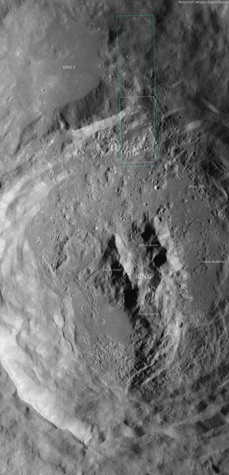
Impact melt ponds adorn the lumpy terraces of King crater. If you look carefully, you can see small fractures in some of the these ponds. 10.9 km field of view from LROC NAC mosaic M1159315479LR, LROC orbit 22783, July 6, 2014; 53.77° incidence angle, resolution 1.16 meters from 114.15 km over 6.41°N, 120.37°E [NASA/GSFC/Arizona State University].
H. Meyer
LROC News System

In the image above, impact melt pooled among the terraces in the walls of King crater, a complex Copernican crater on the lunar farside.

Impact melt is generated when kinetic energy associated with an impact is transferred to the target rock. Shock waves cause the rock to melt nearly instantaneously. The impact melt is flung all over the interior of the crater and some even makes it out of the crater.

Melt splashed on the crater walls tends to drain back down pooling on ledges. This downward flow resulted in a coating of impact melt called a veneer, visible in this region, along with other features like fractures.

Upon closer inspection, these impact melt ponds display the fractures and oddly shaped craters typical of the transitory impact melt ponding at King crater. 1.34 km field of view from LROC NAC mosaic M1159315479LR [NASA/GSFC/Arizona State University].
Fractures in impact melt rocks can be the result of tectonic stresses and cooling and contracting of the impact melt. Sometimes craters also form before the impact melt has fully solidified, resulting in oddly shaped craters that resemble craters that form when pebbles are thrown into mud.

Aside from its rather peculiar central peak, King is rather unique in that the impact melt is not evenly distributed around crater, but rather accumulated in the north-northwest region outside the crater rim. This may be the result of an oblique impact. In the case of an oblique impact, impact melt is concentrated downrange of the incoming projectile.

Contextual view of farside Copernican Age crater King (76.2 km; 4.96°N, 120.49°E), with footprint of LROC NAC mosaic M1159315479LR (orbit 22783, July 6, 2014) and LROC Featured Image field of view. 50 km-plus field of view from LROC Wide Angle Camera (WAC) monochrome (643 nm) observation M176845114CE, LRO orbit 11197, November 25, 2011; 61.87° incidence angle, resolution 57.8 meters from 42.52 km [NASA/GSFC/Arizona State University].
Impact melt forms many exquisite features on the lunar surface such as flows, lobes, pits, fractures, channels, polygonal patterns, and more. Explore the impact melt features of this region in the full NAC mosaic HERE.

Related Posts:

Monday, July 21, 2014

Ballistic boulder at Hecataeus N

A house-sized boulder left a clear impression, immediately beyond the east rim of a young 1.6-km crater (rim crest to the left), all in a full-sized reproduction, 988 meter-wide field of view from LROC NAC observation M182995612R, LRO orbit 12068, February 4, 2012; 48.59° incidence, resolution 85 cm from 83.56 km over 20.98°S, 80.74°E [NASA/GSFC/Arizona State University].
J. Stopar
LROC News System

The boulder above (21.085°S, 80.777°E) in the opening image is likely debris ejected during the violent excavation of the 1.6-km diameter crater immediately to the west (left).

The boulder was deposited ballistically; the distance it travelled and its time of flight are related to its ejection angle and velocity.

For the boulder, was this flight a "small step" or a "giant leap?"

Looking at the image above, we can deduce that the boulder was deposited with enough force to make a noticeable impression in the ground. However, a more forceful landing would have highly fragmented the boulder.

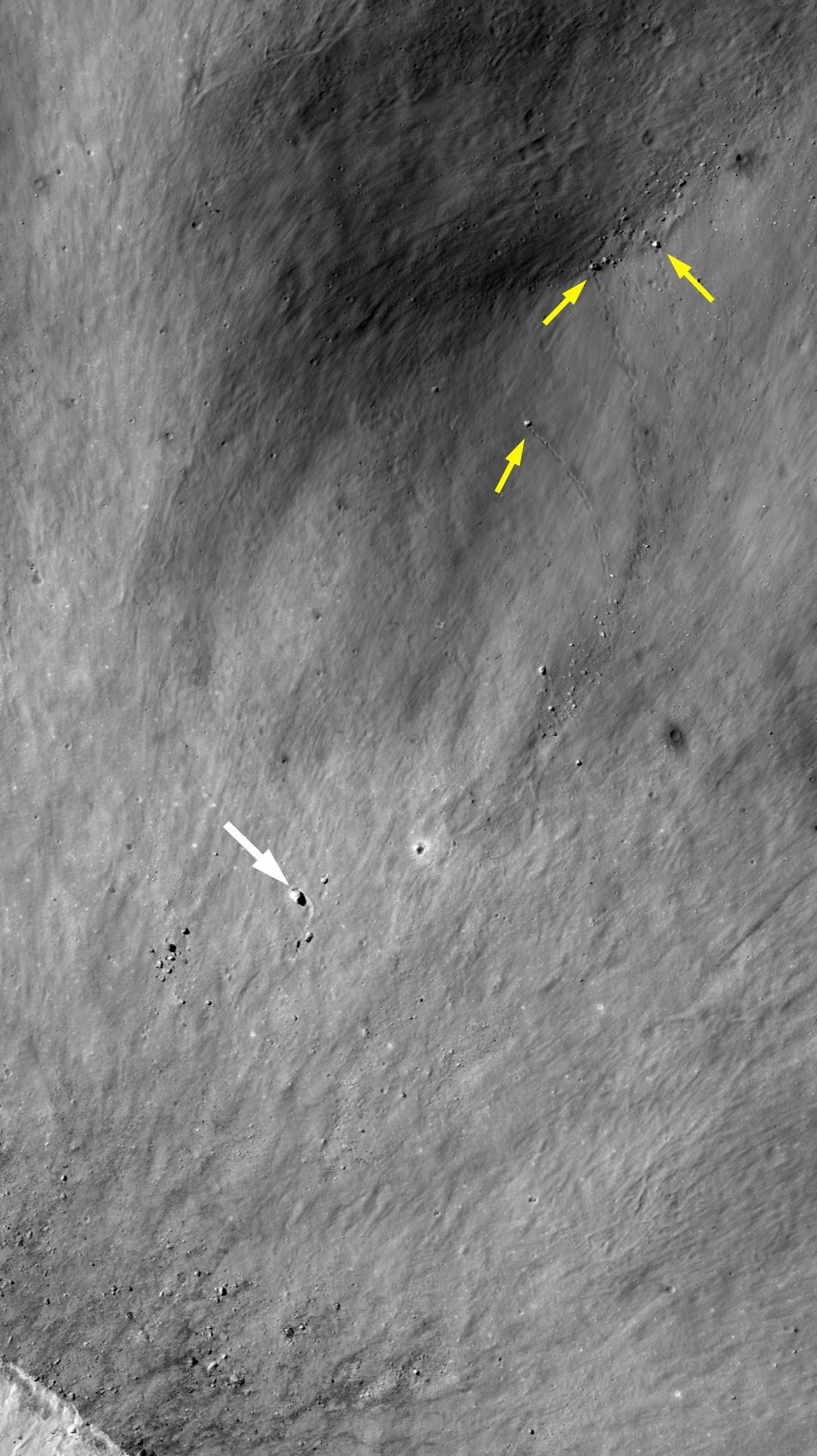
More examples of surface impressions formed by ballistic boulders from the fresh impact near Hecataeus N. Spotty trails mark where boulders rolled into a pre-existing crater (small yellow arrows). Another larger, boulder (25 meters in diameter, large white arrow) was thrown out of the crater to the southwest and carved a furrow in the ejecta blanket, coming to rest when it intersected a pre-existing crater rim (topographic high) [NASA/GSFC/Arizona State University].
The boulder is located about 500 meters east of the crater rim crest, which is only about a third of the crater diameter. Thus, this boulder did not travel very far or very fast.

Explore the entire crater and its ejecta below:

Fresh impact on the west flank of Hecataeus N 4.3 km field of view from LROC NAC mosaic M182995612LR, LRO orbit 12068, February 4, 2012; 48.59° incidence, resolution 85 cm from 83.56 km over 20.98°S, 80.74°E [NASA/GSFC/Arizona State University].
View full-window HERE.

The house-sized boulder (yellow arrow), which left its impression just beyond the east rim of the unnamed young 1.6-km crater that, in turn, sits on the west flank of Hecataeus N, shown in the context of a 7.86 km-wide field of view from LROC NAC mosaic M182995612LR, LRO orbit 12068, February 4, 2012; 48.59° incidence, resolution 85 cm from 83.56 km over 20.98°S, 80.74°E [NASA/GSFC/Arizona State University].
The fresh crater (center) on the southwest slope of Hecataeus N (10.82 km; 20.91°S, 80.944°E) excavates the deepest material originally turned up by "N" while both, in turn, sampled the very ancient Hecataeus interior (southwestern half of this 40-km wide field of view) and, even further, material turned out by Humboldt, to the south (see below), a powerful impact that significantly filled in and covered over the floor of Hecataeus. This is an example of something planners look when making good landing site choices, ones likely to efficiently utilize precious resources. LROC WAC observation M177109146C (604 nm), LRO orbit 11236, November 28, 2011; 68.1° incidence, resolution 58.91 meters from 43.76 km [NASA/GSFC/Arizona State University].
A general schematic map of geological types, representing the relative stratigraphy of the lunar surface affected by Hecataeus and Humboldt, in the south equatorial latitudes of the far eastern hemisphere, where the farside highlands begin, The fresh crater on the west flank of Hecataeus N is marked by an arrow.
The grooves carved by boulders ejected at relatively low velocities are in many ways similar to the spotty tracks etched by boulders sliding, rolling, and bouncing down steep slopes. Also, boulder tracks (like these) often resemble the astronauts' footprints on the lunar surface, since both have relatively recently disturbed the soil in narrow paths. 

In honor of the 45th anniversary of the Apollo 11 lunar landing (July 20, 1969), revisit some of our previous posts about large boulders visited by astronauts:


Finally, revisit some of the best LROC images of the Apollo 11 landing site and see if you can find any large boulders. You should find very few large boulders, as the mission planners sought a low-risk site for the first Moon landing: