Showing posts with label Brown University. Show all posts

Tuesday, December 10, 2013

Strong hints of mixing seen in South Pole-Aitken M3 data

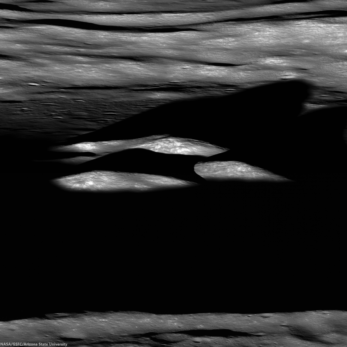
LROCNAC-bhabha_cpeak-1200
Last rays striking the central peaks of Bhabha crater, near the center of South Pole-Aitken basin, an oblique view from the west. LROC Featured Image, "Bhabha sinks into the shadows," July 21, 2010 [NASA/GSFC/Arizona State University].
PROVIDENCE, R.I. [Brown University] — Researchers from Brown University and the University of Hawaii have found some mineralogical surprises in the Moon’s largest impact crater.

Data from the Moon Mineralogy Mapper (M3) that flew aboard India’s Chandrayaan-1 lunar orbiter shows a diverse mineralogy in the subsurface of the giant South Pole Aitken basin. The differing mineral signatures could be reflective of the minerals dredged up at the time of the giant impact 4 billion years ago, the researchers say. If that’s true, then the South Pole Aitken (SPA) basin could hold important information about the Moon’s interior and the evolution of its crust and mantle.

The study, led by Brown graduate student Dan Moriarty, is published in online early view in the Journal of Geophysical Research: Planets.

At 2,500 kilometers across, the SPA is the largest impact basin on the Moon and perhaps the largest in the solar system. Impacts of this size turn tons of solid rock into molten slush. It has been assumed generally that the melting process would obliterate any distinct signatures of pre-existing mineralogical diversity through extensive mixing, but this latest research suggests that might not be the case.

LROCWACDTM-SPA-tour
South Pole-Aitken basin, with Bhabha and Leeuwenhoek craters noted, and more easily seen in the full resolution view, HERE [NASA/GSFC/SVS].
The study looked at smaller craters within the larger SPA basin made by impacts that happened millions of years after the giant impact that formed the basin. Those impacts uncovered material from deep within the basin, offering important clues about what lies beneath the surface. Specifically, the researchers looked at the central peaks of four craters within the basin. Central peaks form when material under the impact zone rebounds, forming an upraised rock formation in the middle of the crater. The tops of those peaks represent pristine material from below the impact zone.

Using Moon Mineralogy Mapper data, the researchers looked at the light reflected from each of the four central peaks. The spectra of reflected light give scientists clues about the makeup of the rocks. The spectra showed substantial differences in composition from peak to peak. Some crater peaks were richer in magnesium than others. One of the four craters, located toward the outer edge of the basin, contained several distinct mineral deposits within its own peak, possibly due to sampling a mixture of both upper and lower crust or mantle materials.

The varying mineralogy in these central peaks suggests that the SPA subsurface is much more diverse than previously thought.

“Previous studies have suggested that all the central peaks look very similar, and that was taken as evidence that everything’s the same across the basin,” Moriarty said. “We looked in a little more detail and found significant compositional differences between these central peaks. The Moon Mineralogy Mapper has very high spatial and spectral resolution. We haven’t really been able to look at the Moon in this kind of detail before.”

The next step is figuring out where that diversity comes from.
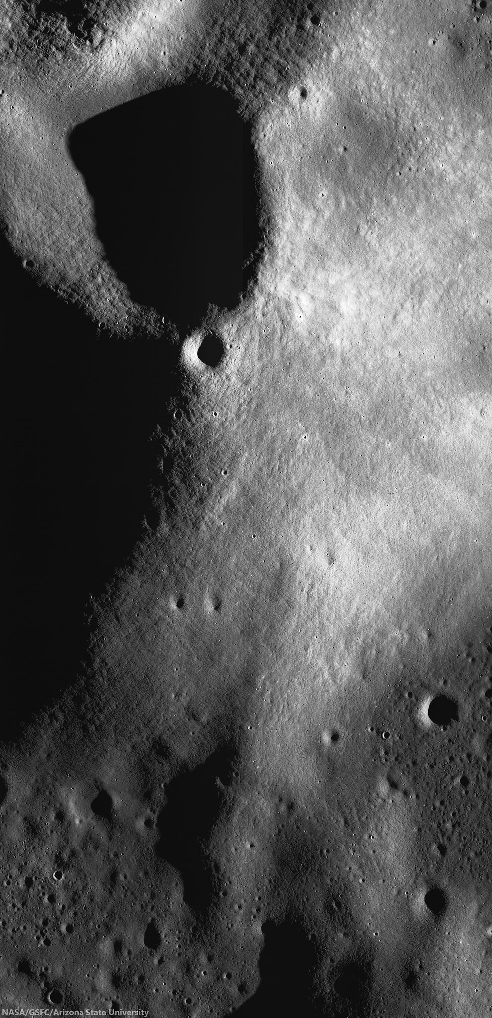
M1124763264LR-NSJ-0603-580x1200-61p-2800x5793
High-resolution view of small crater superpositioned on the south central peaks of Leeuwenhoek crater. Chandrayaan-1 Moon Mineralogical Mapper (3M) data studied by researchers at Brown University demonstrates evidence that lunar mantel was upthrust and exposed when Leeuwenhoek formed, perhaps close to the original transitory crater rim of 4.2 billion year old South Pole-Aitken basin. LROC NAC mosaic M1124763264RL, LRO orbit 17925, June 1, 2013; sunrise angle of incidence 83° resolution roughly 1.6 meters per pixel from 77.84 km [NASA/GSFC/Arizona State University].
It’s possible that the distinct minerals formed as the molten rock from the SPA impact cooled. Recent research from Brown and elsewhere suggests that such mineral formation in impact melt is possible. However, it’s also possible that the mineral differences reflect differences in rock types that were there before the giant SPA impact. Moriarty is currently undertaking a much larger survey of SPA craters in the hope of identifying the source of the diversity. If indeed the diversity reflects pre-existing material, the SPA could hold important clues about the composition of the Moon’s lower crust and mantle.

“If you do the impact scaling from models, [the SPA impact] should have excavated into the mantle,” Moriarty said. “We think the upper mantle is rich in a mineral called olivine, but we don’t see much olivine in the basin. That’s one of the big mysteries about the South Pole Aitken basin. So one of the things we’re trying to figure out is how deep did the impact really excavate. If it melted and excavated any material from the mantle, why aren’t we seeing it?”

If the impact did excavate mantle material, and it doesn’t contain olivine, that would have substantial implications for models of how the Moon was formed, Moriarty said.
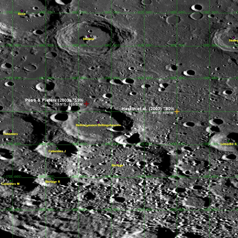
8-SPA-meltpool-787
Two centers? The center of South Pole-Aitken basin is not yet agreed on, partly because it's oval shape is evidence of an oblique impact and also because of its immense age, with much of its original surface now erased. Subsequent impacts, however, has exposed deeper, perhaps the deepest and oldest materials, from the Moon's original formation [NASA/GSFC/Arizona State University].
Much more research is needed to begin to answer those larger questions. But this initial study helps raise the possibility that some of the original mantle mineralogy, if excavated, may be preserved in the Moon’s largest impact basin.

Carle Pieters, professor of geological sciences at Brown, and Peter Isaacson from the University of Hawaii were also authors on the paper. The work was supported by NASA’s Lunar Advanced Science and Exploration Research (LASER) program and the NASA Lunar Science Institute (NLSI).

Sunday, September 19, 2010

LOLA data improves the crater count

Updated September 20, 2010 0051 UT

Another Gap. Following up on a global crater count and mean elevation study of LRO laser altimetry (LOLA), spotlighted by NASA, Sept. 16, another conspicuous, surprisingly oblong gap in the distribution of >20 km craters appears in and around Mare Orientale [NASA/GSFC/LOLA/Brown/SVS].

A study of 5,185 lunar craters of similar size, their global distribution and how their interior elevations deviate from the Moon's global average appears to confirm work by Wilhelms, El Baz and others, published a half-century ago.

Amazingly, those earlier investigators, who improved existing maps of the near side and mapped what was still being learned about the wildly different far side, did not have the benefit of laser altimetry streaming down from the LOLA instrument on board the Lunar Reconnaissance Orbiter (LRO).

More amazing, the Moon's mean elevation, its average radius of 1737.5 kilometers, was far from accurately understood. The LAT package on board JAXA's Kaguya (SELENE-1) isolated the Moon's elusive center further, from within 2 km to within about 200 meters.

In comparison, the Brown University study authored James W. Head is rather like modern lunar instrumentation rated against Apollo guidance computers.

Originally, grid by grid, with slide rule geometry and calculus, plugging time and illumination angles into formula, crater counts of extraordinary accuracy were weaved together by patient investigators. Their published conclusions continue to be confirmed in the mining of laser data from LRO. But questions raised by them stubbornly remain unanswered by 21st century remote sensing. The Ground Truth is still irreplaceable


James W. Head of Brown University has performed a global census 5,185 lunar craters >20 km. in diameter. The study, published in Science, includes a global color-coded tally of the crater's interior elevations, showing deviation from the Moon's global mean "sea level" of 1737.5 km. Not surprisingly, a thinner population of such craters are found in and around familiar near side basins, reconfirming conclusions from long ago that the huge plains represent younger surfaces. (Of craters included in the Brown University census, green = mean global elevation; bluer = below, yellower = above.) [NASA/GSFC/LOLA/Brown/SVS]

So what are these data telling us, confirming theories and restating questions asked by the Light and Shadow slide rule guys of the Apollo era?

Broadly speaking, the Moon holds a reliable record of the history of the Solar System, a record largely lost to water, dynamic weather and plate tectonics on Earth. The Moon's obvious proximity shows this history is also the history of Earth, particularly the history of conditions in that part of the Solar System simultaneously occupied by both bodies.

And the Moon's surface tells a story writ large in bombardment, beginning a very long time ago with the large impactors, like the 4 billion year-old event that formed the 2,100 km-wide South Pole-Aitken basin or the 1290 km-wide Imbrium event that probably happened less than a few hundred million years later. All through the course of the past 4,500 million years, smaller but also respectable kinds of interlopers that punched out the craters in the Head census have continued to "encounter" the Moon with decreasing frequency.

If our dating of features on the Moon's surface is close to being correct, the fall-off in this more common kind of bombardment must have been fairly rapid. Otherwise, the 3.9 billion year-old near side basins, "only" a half-billion years or so after the Moon's magma ocean solidified, would be more punctuated with craters.

The evidence, particularly after studies of the Moon's far side literally entered the picture in 1959, hints that between the formation of SPA and the more familiar near side basins, a gradual decline in these "mid-sized" impacts may have reversed for a 150 to 200 million years before resuming its decline. This is the strongest evidence we have for what's become known as the Grand Bombardment, possibly a juggling of material perturbed as the outer planets, for some unknown reason, waltzed for several million years until stabilizing into their present orbits.


The presentation of the LOLA data study, prepared by the Science Visualization Studio (SVS) at NASA Goddard, was atypical in not including the classic near and far side panels; the two hemispheres shown side by side, centered on the 0° and 180° meridians. The SVS illustrations do include the separate panel above, centered on 90° and 900 frames from their animation. And the animation presents the 5,185 color-coded craters in a way that fancifully builds up gong from east to west as Moon rotates once around. This method does not allow for a view centered over any areas of interest other than the two equatorial slides. If you want to see the census results over Mare Orientale, for example, as at the head of this post, the area of interest falls behind before becoming fully populated [NASA/GSFC/LOLA/Brown/SVS].

Nevertheless, as the the Moon rotates, another second gap appears in the crater count, this time arguably in the the lunar highlands but hardly typical in composition, an oblong gap 2000 kilometers north to south and 1200 km wide centered on Mare Orientale.

Orientale was a late comer, slightly smaller and perhaps more energetic than the great basin-forming impacts of a billion years earlier. If dating methods are reliable, then the fall-off in >20 km-wide impact events had fallen to a trickle by the time of Orientale's formation, 3.1 billion years ago. Some studies hint the Orientale event was energetic enough to have caused an upwelling of molten material in the near side basins, the many ponds of mare material within South Pole-Aitken and elsewhere.

Additional Reading:
The Moon through LRO's eyes
Kelly Beatty
Sky & Telescope

Friday, September 10, 2010

Chandrayaan-1 M3 lunar data released to Planetary Data System

Updated September 14, 2010 1336 UT

The M3 release of Optical Period 1, Level 1B data products, is now accessible via the online data volumes. Corresponding Level 0 data products are forthcoming as they are being updated by the team to ensure ease of use and compliance with PDS standards. More info can be found at the Chandrayaan-1 M3 mission page.

Note: The national treasure Charles A. Wood, curator of LUNAR PICTURE of the DAY (LPOD) posted what many will discover to be a more understandable summary of this important development HERE. - Ed.

Carle Pieters
Principal Investigator
Moon Mineralogy Mapper (M3)
Brown University

It is with great pleasure to announce that the first installment of Moon Mineralogy Mapper (M3) data has been released and is now available through PDS: http://img.pds.nasa.gov/ http://pds-imaging.jpl.nasa.gov/volumes/m3.html

M3 is an orbital imaging spectrometer that operated from 450 to 3000 nm. It was built at JPL and flown on India’s Chandrayaan-1 lunar spacecraft. Almost all data were taken in the lower resolution “Global” mode that includes 85 simultaneous co-registered spectral channels. More information about M3 can be found at the M3 website (being updated): https://m3.jpl.nasa.gov/NEWS/

This first release is Level 1B (L1B) spectral image cubes calibrated through radiance at sensor for Optical Period 1 (OP1) of Chandrayaan-1 operations, along with all their selenolocation and observation geometry back planes. No data re-sampling has been performed. L1B data for Optical Period 2 (OP2) are being processed and are expected to be released in December.

Higher-level calibrations continue, and Level 2 data (~reflectance) for both OP1 and OP2 are scheduled to be released in June 2011.

The M3 science team is planning a tutorial session to be held early in the week at Fall AGU for those who would like to learn more about how to work efficiently with M3 data. We will also schedule short presentations at the PDS exhibit during the week. The timing for both of these will be set after the AGU program is determined.

Best wishes from the M3 Team

Wednesday, April 7, 2010

A New Lunar Globe as seen by Chandrayaan Moon Mineralogy Mapper: Image Coverage, Spectral Dimensionality and Statistical Anomalies


The composition of the Moon's surface, as mapped in unprecedented detail by the NASA-built Moon Mineralogy Mapper (M3), flown by the Indian Space Research Organisation (ISRO) Chandrayaan-1 lunar orbiter (2008-2009) [NASA].

Boardman and Pieters, et.al
AIG, LLC & Brown University; NASA JPL, USGS, University of Maryland, The Bear Flight Center, ACT, NASA GSFC & University of Tennessee

The Moon Mineralogy Mapper (M3), a NASA Discovery Mission of Opportunity, was launched October 22, 2008 from Shriharikota in India on board the Indian ISRO Chandrayaan-1 spacecraft for a nominal two-year mission in a 100-km polar lunar orbit. M3 was a high-fidelity imaging spectrometer with 260 spectral bands in Target Mode and 85 spectral bands in a reduced-resolution Global Mode. Target Mode pixel sizes are nominally 70 meters and Global pixels (binned 2 by 2) are 140 meters, from the planned 100-km orbit. The mission was cut short, just before halfway, in August, 2009 when the spacecraft ceased operations.

Despite the abbreviated mission and numerous technical and scientific challenges during the flight, M3 was able to cover more than 95% of the Moon in Global Mode. These data, presented and analyzed here as a global whole, are revolutionizing our understanding of the Moon. Already, numerous discoveries relating to volatiles and unexpected mineralogy have been published [1], [2], [3]. The rich spectral and spatial information content of the M3 data indicates that many more discoveries and an improved understanding of the mineralogy, geology, photometry, thermal regime and volatile status of our nearest neighbor are forthcoming from these data. Sadly, only minimal high-resolution Target Mode images were acquired, as these were to be the focus of the second half of the mission.

This abstract gives the reader a global overview of all the M3 data that were collected and an introduction to their rich spectral character and complexity. We employ a Principal Components statistical method to assess the underlying dimensionality of the Moon as a whole, as seen by M3, and to identify numerous areas that are low-probability targets and thus of potential interest to selenologists.

M3 Lunar Coverage Overview: M3 covered nearly the full Moon in Global Mode, but only collected a very small number of Target Mode images, due to the early demise of the spacecraft. There were a number of technical challenges during the mission that have complicated the data processing and calibration. These include thermal issues, loss of the star trackers and a raising of the orbit to 200-km in May of 2009. M3 was designed to operate over four three-month Optical Periods (solar beta angles 30 degrees or less).

Thermal issues caused us to also operate well outside these high-sun periods. M3 was able to complete two Optical Periods (OPs), each broken into sub-OPs based on instrument or spacecraft events and status. Figure 1 shows the M3 coverage during the five sub-OPs along with a cumulative coverage index of the gaps, the nearly full Global coverage and the limited Target images.


Figure 1: M3 coverages by five sub-Optical Periods (OP1a, OP1b, OP2a, OP2b, OP2c) and a cumulative coverage index (black/gray/white = gaps/global/target).

Spectral Dimensionality: Principal Components analysis is a simple, yet powerful, tool to begin to explore the M3 data dimensionality, its spanning spectral subspace and to quickly indentify lunar areas that are low-probability or anomalous. Figure 2 shows the eigenvalues on a log scale, for the entire Global dataset.


Figure 2: M3 full-mission Principal Component eigenvalues, plotted on a natural log scale with arrows delineating prominent breaks in signal-to-noise slope.

The M3 data set, treated as a global whole, has more than twelve distinct dimensions above the start of the noise floor. Indications of more subtle spectral signatures continue out to nearly dimension 60. As the calibration improves we expect the noise/artifact floor to lower and the signal space to increase in dimensionality. Figure 3 shows eigenvectors 1 through 12.


Figure 3: M3 full-mission Principal Component eigenvectors one through twelve.

The interplay of the spatial and spectral information is illustrated in Figure 4. It shows the PC images 1-10 for OP1b. While PC1 captures the familiar Moon, the RGB composites of PCs 2-10 begin to demonstrate the rich spectral diversity of the M3 Global data set.


Figure 4: M3 Principal Component images (nearside hemispheric view of OP1b data): PC 1 (as grayscale); PCs 2, 3, 4; PCs 5, 6, 7; PCs 8, 9, 10 (as RGB).

Statistical Anomalies: The Principal Components describe and orient the data-spanning spectral subspace, through the eigenvectors and eigenvalues of the covariance matrix. They also define the complementary null space. A measurement of the power of each spectrum in the null space is a simple yet robust anomaly detection method. Figure 5 shows a reference image for OP1b data over a color-coded anomaly detection image. While some instrument and data artifacts are obviously exposed, many of the small contiguous areas represent local regions of low-probability spectral signatures and bear further investigation.


Figure 5: OP1b reference image over color-coded anomaly detection result using PC null space power.

Summary and Conclusions: M3 covered nearly the full Moon in high-fidelity, 85-band Global Mode imaging spectrometry data. The data are informationrich, both spectrally and spatially, and are just beginning to help us build a new, hyperdimensional global view of the Moon.

References: [1] Pieters, C. M. et al. (2009) Science, 326, 568–572. [2] Pieters, C. M. et al. (2010) LPS XLI, this volume. [3] Sunshine, J. et al. (2010) LPS XLI, this volume.

Acknowledgments: We gratefully acknowledge support from the NASA Discovery Mission Program Office and profoundly thank our Indian launch and spacecraft hosts ISRO and their remarkable Chandrayaan-1 Mission Ops team.

KAGUYA/Chandrayaan-1 Cross-Calibration Meeting Ahmedabad 8-9 Feb. 2010

Thursday, February 11, 2010

Chandrayaan-1 M3 mapper study reveals new lunar rock family

Carle Pieters
Professor of Geological Sciences
Brown University


R. Ramachandran
The Hindu

The Moon Minerology Mapper (M3) on Chandrayaan-1, which famously discovered the presence of water and hydroxyl molecules on the lunar surface material last year, has now identified a new lunar rock type on the far side of the moon. The M3 is a NASA instrument. This was reported here on Monday by Carle Pieters of Brown University, lead author of the present study, at the Sixth Chandrayaan-1 Science Meeting being held at the Physical Research Laboratory (PRL), a unit of the Indian Space Research Organisation (ISRO).

The rock-type is dominated by a mineral termed as ‘magnesium spinel.’ Spinel is a generic name given to a class of minerals having the chemical formula AB{-2}O{-4} and the usual spinel formations found in lunar rocks is an iron-magnesium admixture of the form (Mg, Fe)(Al, Cr){-2}O{-4}. These rocks are usually found along with magnesium-iron silicate (olivine) and calcium-rich aluminium silicate (pyroxene).

Unique feature

According to Professor Pieters, the interesting feature of the new rock type is that it is exclusively composed of magnesium-rich spinel “with no detectable pyroxene or olivine present.” This, she said, does not easily fit with current lunar crustal evolution models.

Rich in anorthosites

The generally accepted characterisation of the lunar crust is based principally on retrieved lunar material by the Apollo-Luna missions and meteorite samples. The crust is described as a rocky accumulation, basically rich in calcium-aluminium silicates (anorthosites) infused with a mix of compounds containing magnesium and iron (‘mafic’ minerals).

However, the western ring of the Moscoviense Basin of the moon appears to be one of the several discrete areas that exhibit unusual compositions relative to their surroundings, but without morphological evidence for separate geological processes leading to their exposure.

The findings are based on data acquired by M3 in January 2009 during the first observation period of Chandrayaan-1 from its initial 100 km altitude orbit over a 40 km wide strip field of view, with a spatial resolution of 140 m/pixel. The mapping was done using the emission spectrum of the surface over the wavelength region 460-3000 nanometres with a spectral resolution of 20-40 nm.

Five anomalous areas

The general composition of the area observed had a low abundance of mafic minerals and a high abundance of feldspathic minerals such as pyroxene. While this was consistent with earlier observations, five anomalous areas that are widely separated were seen along the lower elevations of the ring (see pic.). Interestingly, no unusual feature or any compositional boundary was seen for any of these areas.

Calcium-rich pyroxene is prominent in areas 2 and some parts of 3 and 4. Olivine is prominent across 5 and parts of 4. In contrast, the whole of region 1 and part of region 3 were exceptionally dark in the images. This, according to Professor Pieters, is because of the high absorption that the areas seem to have in the 2000 nm region, together with the near complete absence of pyroxene or olivine (less than 5 per cent) as indicated by the lack of any absorption around 1000 nm.

While regions rich in olivine or pyroxenes have been seen in other basins, this is the first time a magnesium-rich spinel region has been identified. “The clear interpretation of these spectra is that the surfaces represent a new rock type dominated by magnesium-rich spinel with no other detectable mafic minerals,” Professor Pieters said.

No easy explanation

There does not seem to be any easy explanation for the occurrence of these spinel formations. Since magnesium-spinels have been seen in some asteroids, one possible explanation is that the source is exogenous asteroid or comet impacts. However, there is no evidence of any impact or dispersion of rubble pile and the like from the impact’s aftermath.

An interesting feature of the Moscoviense Basin is that the crust in the region is much thinner, compared to other basins. This is indicative of a magma upturning over much recent time scales as compared to other regions. Also this offers one possible explanation for the occurrence of magnesium-rich minerals because these are very dense and would have been deposited right at the bottom during the cooling and crystallization of the crust. The recent upturning may have brought it up from the lunar deep crust during the basin formation, Professor Pieters pointed out.

Lunar crust origin

But that still does not explain the localised nature of the anomalous regions that extend only about a few kilometres across, she said. “Creating foreign deposits without a trace of their origin is hard to do. We, therefore, favour a lunar crust origin,” she said. “But even that interpretation is not entirely satisfactory. We need to fully characterise the morphology of the anomalous regions with high resolution data from TMC [ISRO’s Terrain Mapping Camera] images,” she added.

- Heads Up to Pradeep

Friday, December 4, 2009

LRO DIVINER LPSC Symposium, February 2010


It's beginning to look like the 41st Annual Lunar and Planetary Science Conference at The Woodlands in Texas, March 1-5, 2010, will be among the very best places to get any advance view of the long-on-promise data from the Lunar Reconnaissance Orbiter and its seven experiments now in lunar orbit.

The Lunar Reconnaissance Orbiter (LRO) Diviner instrument team will host a symposium on the Sunday afternoon before the LPSC to acquaint the Planetary Science community with the Diviner experiment, its dataset and scientific findings to date.

The meeting will be held in the Montgomery Ballroom of the the Woodlands Waterway Marriott Hotel and Conference Center in Houston, TX - the same hotel hosting the LPSC 2010 meeting, and the Brown-Vernadsky Microsymposium entitled “Compositional Structure of the Lunar Crust: The New View from the Moon” (http://www.planetary.brown.edu/html_pages/micro51.htm).

The Diviner symposium will directly follow the Brown-Vernadsky Microsymposium, scheduled for all day Saturday, February 27 and again on Sunday morning, February 28.

A detailed agenda for the Diviner Symposium will be posted in advance of the meeting on the LRO Diviner instrument site.

Thursday, October 15, 2009

LCROSS 'smashing success for Schultz'

Ana Alvarez
The Brown Daily Herald

A NASA spacecraft slammed into the moon early last Friday morning, exploding into a cloud of debris — and Professor of Geology Peter Schulz was elated.

The rocket’s mission — to search for signs of water in a crater near the moon’s south pole by analyzing the debris produced in the crash — was a “complete success,” said Schultz, a co-investigator on the project.

The objective of the Lunar Crater Observing and Sensing Satellite, or LCROSS, mission was to determine if the make-up of the debris suggest a substantial amount of water is present in the crater, Schultz said.

If so, lunar mining stations could provide future water resources for Earth, he said.

Schultz is currently at NASA’s Ames Research Center in California, studying the data gathered from Friday’s impact. NASA will release initial conclusions soon, but the official scientific results of the mission will not be released until the American Geophysical Union’s Fall Meeting in December.

Read the full article, HERE.

Pieters-led team made historic lunar scan

Monique Vernon
The Brown Daily Herald

Water molecules have been found on the moon by a research team headed by Professor of Geology Carle Pieters (pictured, Left). But like many momentous scientific advances, the discovery was made almost by accident.

“You don’t expect any water on the moon,” Pieters said, and neither did her research team, which was studying lunar mineralogy. But when the team happened upon indications of water that at first confused them, they investigated further and discovered they were genuine.

“When our team saw a clear signature of water on the surface, we thought it was wrong,” Pieters said.

After months of probing and testing to try to resolve the disparity, the team later concluded that there are molecules of water and hydroxyl — a functional group consisting of hydrogen and oxygen — on the moon’s surface.

The team’s conclusion appeared in an issue of the journal Science alongside two other articles that concurred with Pieters’s findings. One research group’s instrument was on its way to Saturn and found similar readings using their spectrometer, while the other’s was on its way to a comet.

When the Indian Space Research Organization offered to carry foreign instruments on their Chandrayaan-1 spacecraft, Pieters and her team went to work on forming a detailed proposal to NASA to acquire funding to construct the instrument, known as the Moon Mineralogy Mapper, or M3. The project was accepted by NASA and the ISRO, and the Indian spacecraft containing the M3 launched successfully in October 2008.

With 10 months of data from the craft, the team was able to observe the water and hydroxyl molecules with a “unique detection using spectroscopy,” Pieters said.

“It is such a fantastic look at the way science works in the real world,” said Postdoctoral Research Associate in Geological Sciences Jeff Nettles. As a co-author of the Science paper, his role during the mission was to use software that processes and analyzes geospatial imagery to help analyze the surface.

Read the full article, HERE.

Monday, September 28, 2009

ESA: Novel Textile Antenna

Textile antenna Through the ESA Advanced Research in Telecommunications Systems (ARTES) 5 project 'Textile Antennas', the Finnish Patria Aviation Oy company has demonstrated that an antenna can be built using textiles that can be worn and used for personal satellite communication. The antenna is here seen attached to the sleeve of a jacket. [Patria Aviation Oy-ESA]

Thursday, August 20, 2009

OSEWG talks joint human & robotic sortees

Brian Enke

On August 5 and 6, the Optimizing Science for Exploration Working Group (OSEWG) held a workshop at the Lunar and Planetary Institute in Houston and discussed ways robots and humans could cooperate in future lunar missions.

Experts from the science, exploration, and robotics communities walked through various lunar mission scenarios and offered insights into how each group could support the overall mission objectives while reducing budgets and risk.

The all-star lineup of presenters included Chip Shearer (LEAG), Jim Head (Brown University), Chris Culbert (NASA-JSC), Rob Ambrose (NASA-JSC), Brian Wilcox (NASA-JPL), and David Wettergreen (Carnegie Mellon University). Private industry interests and abilities were represented by one presenter (Chel Stromgren - SAIC) and several conference attendees from aerospace companies like Boeing and Lockheed Martin.

Read the review HERE.

Monday, August 3, 2009

Magma Ocean theory advances, 'First Results' from Chandrayaan-1's 3M

Extent of M3 “warm” data-take across the Orientale Basin. The basemap is Clementine UVVIS 750 nm data and LAC chart locations. Basin rings are labeled in blue.

Minerology of the Lunar Crust in Spacial Context: First Results from the Moon Minerology Mapper (M3) - Pieters, et.al. (Dept. Geological Sciences, Brown University, AIG, NASA JPL, USGS (Denver), Bear Fight Center, WA, ISRO-PRL, ISRO-NRSA, ACT, NASA Goddard, College of Charleston, PSI, U. of MD, U. of TN. & DARPA.)

Introduction: India’s Chandrayaan-1 successfully launched October 22, 2008 and went into lunar orbit a few weeks later. Commissioning of instruments began in late November and was near complete by the end of the year. Initial data for NASA’s Moon Mineralogy Mapper (M3) were acquired across the Orientale Basin and the science results are discussed here. M 3 image-cube data provide mineralogy of the surface in geologic context. A major new result is that the existence and distribution of massive amounts of anorthosite as a continuous stratigraphic crustal layer is now irrefutable.

Read the published report HERE,
Chandrayaan-1 Science Team Meeting, Bangalore 9-11 Mar. 2009

Saturday, June 13, 2009

A New Era of Lunar Exploration


Everything old is new again.

The familiar telescopic Imbrian Age rectilinear fault Rupes Recta, or "straight wall," on the east bank of Mare Nubium, with far younger Copernican Age (1.1 billion year-old) companion crater Birt is seen as the unaided human eye would view it from lunar orbit, from Kaguya's NHK HDTV camera.

Dr. Carle Pieters, Deptartment of Geological Science
Brown University

"I am very excited about this new era of exploration that we are entering. The technical capability of the sensors, and the advancement with the young scientists that are becoming involved in the field are opening a new era of exploration. Lunar exploration is a long-term project."

"It probably has a hundred-year horizon. And we don't know what resources are going to be most useful. We don't know what application will be there a hundred years from now, but it will happen on that kind of time frame. And it's very encouraging to see that the international community is involved, that it's not just one country. I think the moon is one of the best examples of how different nations can work in a cooperative and peaceful manner on a highly technical activity."

Read JAXA feature story HERE.

Monday, February 2, 2009

Carle Pieters meets with ISRO in Bangalore

Divyah Ghandi of the Hindu reports Dr. Carle Pieters, who heads the design team for NASA's Moon Mineralogy Mapper on board the ISRO 's Chandrayaan 1, joins Apollo 17 astronaut Dr. Harrison H. Schmitt and many others suggesting the Moon might provide resources enough to pay the cost of exploring space beyond.

It is also likely such resources might drive that exploration.

"Out of a high profile closed-door meeting of the Indian Space Research Organisation (ISRO), NASA and the ESA held in Bangalore, Friday," Ghandi writes, "to evaluate the first 100 days of the Chandrayaan mission, Dr. Pieters "spoke to The Hindu about the Moon Mineralogy Mapper, an imaging spectrometer developed by her team."

“Scientists around the world have come to understand that the Moon is clearly the stepping stone for the future of the human species beyond the Earth,” according to Dr. Pieters, celebrated among the Geological Sciences faculty at Brown, and also Principal Investigator for the 3M, one of eleven instruments onboard Chandrayaan.

“So, it's no coincidence that four countries – India, China, Japan and U.S. – are showing simultaneous interest in the Earth’s celestial neighbor.”

Professor Pieters said, "the Moon could support future explorations of Mars or near-Earth asteroids" through fuel and “if we get lucky” water resources too, she said.

Thursday, December 25, 2008

Chandrayaan 3M's colorful detail of regolith Fe


IMAGE CREDIT: NASA/JPL/BROWN UNIVERSITY: Different wavelengths of light provide
new information about the Orientale Basin region of the moon in a composite image
taken by NASA's Moon Mineralogy Mapper, a guest instrument aboard the Indian
Space Research Organisation's Chandrayaan-1 spacecraft.

A flurry of news hinting incorrectly of a "discovery" of Iron compounds on the Moon should do little to detract Brown Univerity's "3M" instrument being listed among NASA's top science, exploration and discovery stories of 2008. Thankfully, NASA JPL has been kind enough to put together a website with the latest information available HERE. (Which, in turn, should take nothing away from the growing, informative M3 Science Blog maintained by Brown.)

Iron oxides, particularly on dark "reddened" Near Side mare regoliths, are well-known markers of lunar morphology, for example "optical maturity," or "OMAT," though this last single example may only reliably demonstrate the exposure of small areas on the Moon's surface back 500 to 900 million years. Cosmic Iron also bonds well and marks with Titanium and otherwise volatile elements such as Oxygen.

An abundance of Thorium, a definite source of fuel for fission power, also marks the lunar maria on the Near Side. Japan's Kaguya team reports point signatures of isotopes of Uranium also, as a growing international fleet of lunar orbiters add anticipated detail to our knowledge of the lunar surface.

Brown University's "3M" Moon Minerology Mapper, set to fly on NASA's LRO (Lunar Reconnaissance Orbiter) as early as late April has a twin on-board India's Chandrayaan 1, which arrived in lunar orbit in November.

Brown 3M Principal Investigator Carle Pieters has commented on the most detailed minerology map of the lunar surface, part of the Orientale Impact zone, unveiled December 17.

“The Moon Mineralogy Mapper provides us with compositional information across the moon that we have never had access to before”, said Pieters. “Our ability to now identify and map the composition of the surface in geologic context provides a new level of detail needed to explore and understand Earth’s nearest neighbor.”

The image revealed changes in rock and mineral composition, indicated the abundance of iron-bearing minerals such as pyroxene, and provided a new level of detail on the form and structure of the region’s surface.

Wednesday, March 12, 2008

Carancas: Per usual, was highly unusual

Every time we turn a corner in exploring the known Universe, we encounter phenomena that raise more questions than are answered. Often we are satisfied with the good answers, but whole schools of thought appear when the vines of hypothesis are cleared away.

It’s cliché, but that’s why they call them clichés. More often than not, they’re true.

And again this week we are reporting the results of studies from League City, Texas and the Lunar and Planetary Science Conference which are leaving specialists in their fields feeling like they’ve tried to sip from a fire hose, or, if you prefer, an effect once cliché in Washington, and a phenomena that may still be true; MEGO, an appropriately NASA-sounding abbreviation to indicate a topic’s “Glaze Factor."

My Eyes Glaze Over. So it was when the Martian Chronicle sounded a Heads Up to we Selenologists out here by wandering from breakout sessions on Sol IV, stumbling out of lectures from sheer overload and into sessions on NASA’s proposed Internationally-shared platforms and communications nodes when Moon Traffic Control really becomes a problem, NASA believes, in only a bit more than a decade.

We often forget the surface of Earth’s Moon is roughly the size of the land area of Africa. If the legend is correct that the only two registered automobiles in Kansas in 1902 actually collided at a rutted four-way intersection, then the odds will start getting tight, and sooner than most of those paying for this show can yet imagine. NASA is right to plan to avoid the expected.

But what of the unexpected?

Certainly we have a pretty good bead on the speeds of cometary debris and other regular hazards, including those that are man made, while traveling in Earth Orbit, Trans Lunar Space and possibly in Lunar Orbit. If Vanguard can survive in orbit for fifty years, then it follows that the incidence of truly anomalous fragments of matter are quite rare. Thanks to legendary Fred Whipple, we can even build robust shielding with gapped double hulls, for most scenarios.

But… and there is a but in every crowd, the surface of our Moon testifies of bombardments Grand, old and new, from every direction, and possibly with periodicity. And the existence of the Moon itself testifies of bombardment. We should take a hint, and remember that while the known Universe is headache-producing in imagined size, the Solar System, the Inner Solar System and the Earth Moon System in particular, is getting smaller all the time.

And our understanding even of our relationships with one another is still rather primitive by the standards of our ideals, let alone the challenges of survival on the Moon.

And what of Carancas? Inquiring minds want to know, and what we’re learned is whatever created the buzzworthy hole hewn out in Peru last September wasn’t your average meteoroid.

I’ll hand over, with Hat Tip to MIT’s essential Ksjtracker, for background, and with only these snippets as a teaser:

last September’s news flurry of a perplexing, some say steaming, hole in the ground - rapidly filled by ground water - in the Peruvian country side. Some locals claimed the fumes made them ill. Last we heard, it was a meteor strike, but a puzzler. That still looks to be the case, a Brown U. professor told the Lunar and Planetary Society meeting in Texas yesterday.”

The news, in brief, is that the Carancas Fireball was not merely a bolide from above. It must, it says here, have hit the ground at around 15,000 miles per hour to have made such a deep hole, thrown debris hundreds of yards, and, it turns out, left telltale microscopic shock damage in mineral grains. (Imagine hitting the ground so hard that the sand doesn’t just scatter, it breaks). And bam, there go standard explanations of what is supposed to happen to all smallish stony meteoroids when they hit the atmosphere - which is to break apart, slow down, and perhaps detonate Tunguska-style as they dump kinetic energy abruptly into the air. One then gets a debris field of meteorites, not one big plunk. (Iron meteors, in contrast to stony ones such as this was, do often stay intact.)

The prof thinks, somehow, this one may have morphed inside its fireball into a streamlined shape and punched through the air in one piece…”

Reuters Maggie Fox reports - as the release has it - that the terminal velocity was more than 40 times what experts would have expected. The professor explains to her the pieces should have just hit, “plop” - nothing like what actually happened ; National Geographic News Richard Lovett writes it “punched holes in long-held theories” and has the prof. describing it as like a needle that pierced the atmosphere ; Tech Herald Rich Bowden (pretty small outlet but good hed: How a misbehaving meteorite changed the rules ) "

Grist for the Mill: Brown University Press Release