Showing posts with label Antoniadi. Show all posts

Tuesday, August 5, 2014

Fractures and boulders on the floor of De Forest

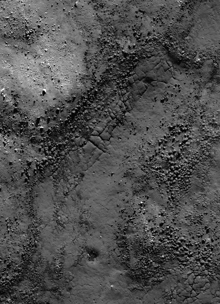
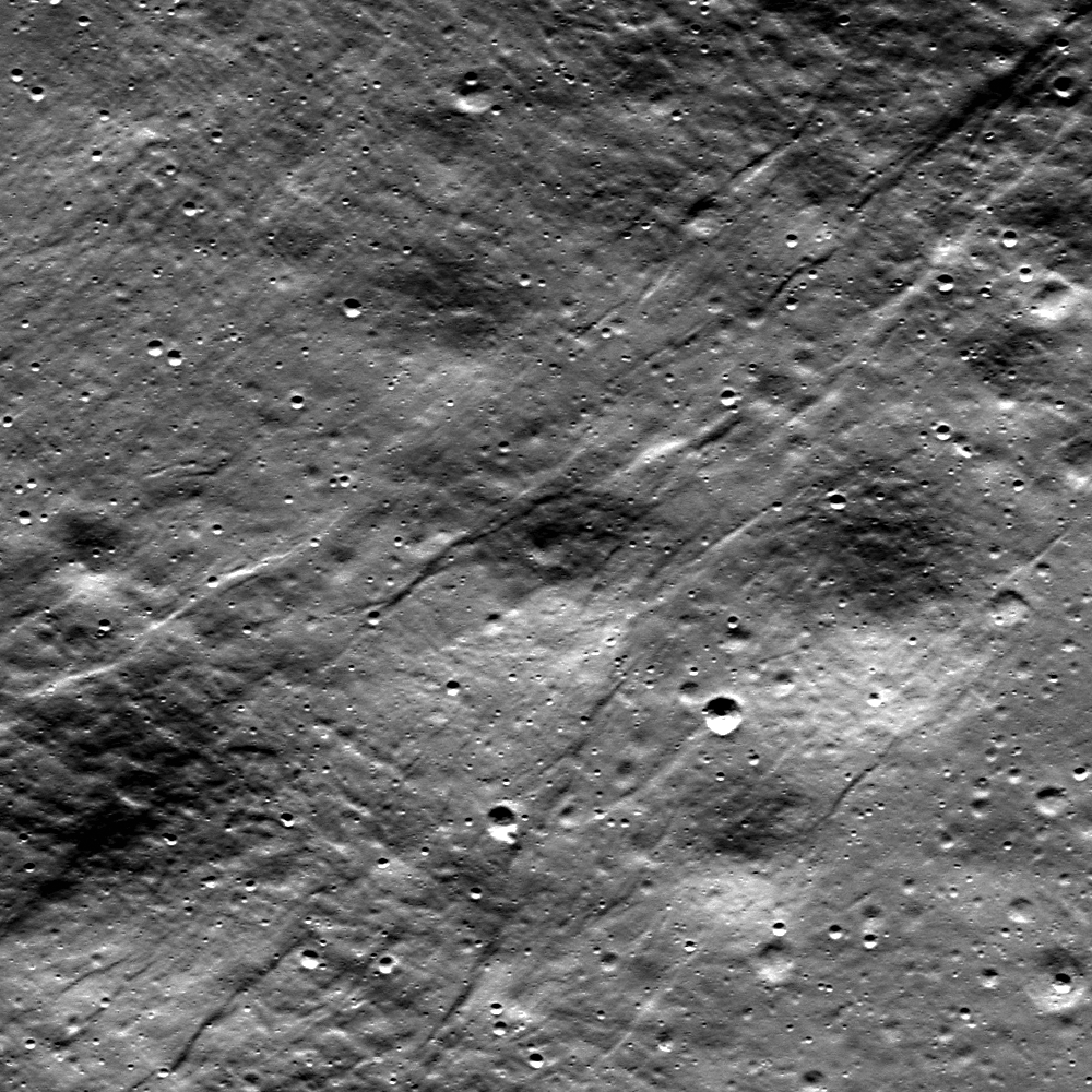
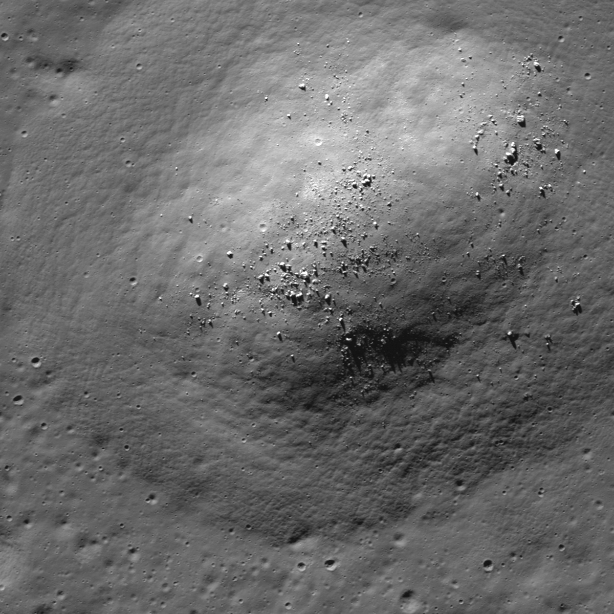
Fractured impact melt left the interior of De Forest crater (56.25 km; 76.94°S, 196.67°E) lined with boulders. 665 meter-wide field of view from LROC NAC observation M125650563L, 665 meter-wide field of view from LRO orbit 3650, April 11, 2010; 78.87° incidence angle, resolution 57 cm from 55.16 km over 77.1°S, 197.94°E [NASA/GSFC/Arizona State University].
Hiroyuki Sato
LROC News System

Today's Featured Image highlights a portion of the interior of De Forest crater (56.25 km; 76.94°S, 196.67°E), which is located inside the South Pole–Aitken basin.

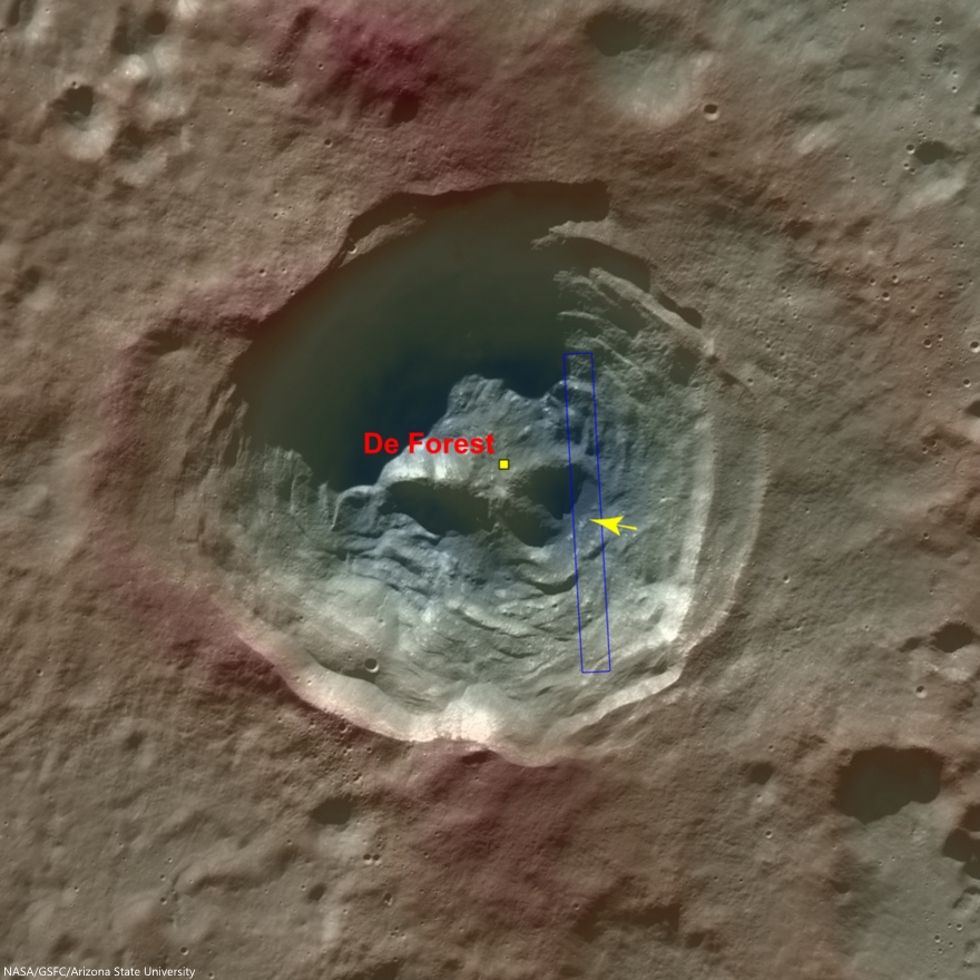
The cavity of De Forest crater exhibits prominent terraces of collapsed materials surrounding the central peak (see context imagery following).

The topographic low, east of the central peak, was largely coated with hot impact melt which formed a hard crust as it cooled; a portion of this melt is seen in the opening image. 

Context view of De Forest crater (56.25 km; 76.94°S, 196.67°E) consisting of LROC WAC monochrome mosaic (100 m/pix) overlain with colorized WAC stereo DTM (GLD100, Scholten et al., 2012). View centered on 76.92°S, 197.51°E. Footprint of LROC NAC observation M125650563L, April 11, 2010, outlined in blue, source of high-resolution view of the area designated with a yellow arrow (LROC Featured Image released August 5, 2014) [NASA/GSFC/Arizona State University]. 
Much of the area of the opening image is covered by numerous boulders, some of which are up to approximately 15 meters across.

The smooth surface extending in lower-left to upper-right is impact melt that cooled to form solid rock, and is now fractured in regular patterns along the edge. Impact melt that was splashed on the crater's walls and its central peak formed a coating that quickly cooled to solid rock.

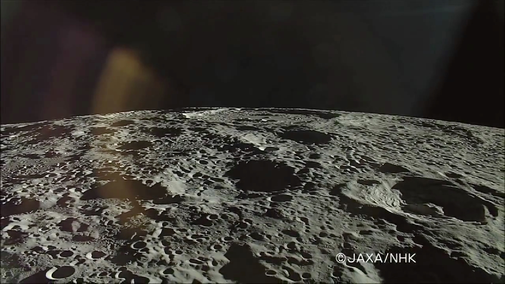
On the true "backside" of the Moon, De Forest (right) is situated well inside South Pole-Aitken impact basin, between Antoniadi (upper left, near horizon), host of the Moon's lowest elevation (-9094 meters) and Shackleton (not pictured), host of the Moon's south pole. HDTV still from Japan's lunar orbiter Kaguya (SELENE-1) in 2008 [JAXA/NHK/SELENE].
Later, it is likely that nearby moonquakes caused these brittle rock coatings to fracture, providing the source of boulders we now see on the lower reaches of the crater floor.

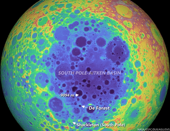
De Forest's position in the far south Farside is an area hosting Permanently Shadowed Regions (PSR's). The neutron detection experiment on-board LRO (LEND) has built up signatures consistent with cold-trapped volatiles, like water ice, in the vicinity. Image from Science Visualization Studio tour of SPA, larger image HERE [NASA/GSFC/Arizona State University/DLR/SVS]. 
As you can see in the following full NAC frame, an enormous number of similar boulders are found along the smooth melt deposits on the floor of De Forest crater. 

Explore this boulder-rich crater in the full NAC frame, HERE.

Related Posts:

Thursday, February 14, 2013

Numerov's Graben

Normal faults in regolith formed remarkably small graben in Nectarian age Numerov crater (70.7°S, 160.7°W). Only a handful of small craters superpose the faults, indicating a young age. LROC NAC M171619370RE, image width is 600 m [NASA/GSFC/Arizona State University].
Drew Enns
LROC News System

Graben on the Moon come in a variety of sizes. Some of the larger rilles in the maria stretch for several tens of kilometers and can be a few kilometers in width. These linear rilles are thought to be the result of extensional stresses near the edges of the maria and are thus graben.

Since the mare basalts are dense, they weigh down the crust in the center of the deposit, pulling rock near the margins inward.

However, the Featured Image today shows much smaller graben that span only hundreds of meters in length and tens of meters in width. To complicate matters, these graben are not in mare basalts, they are inside a crater!

Context image for today's Featured Image. The graben are pointed to by the arrow. A nearby lobate scarp extends from A to A', its low relief enhanced by the low Sun mosaic. Image width is 100 km [NASA/GSFC/Arizona State University].
The LROC Wide Angle Camera (WAC) context image (above) helps us decipher the origin of these graben, as a nearby lobate scarp can be seen at this scale. Lobate scarps form in compressional stress environments as layers of rock or regolith fold and thrust upwards. The thrusting might cause nearby crust or regolith to uplift and bend.

The graben and scarp are only hundreds of meters apart which argues for a compressional interpretation.Thus the interplay between compressional and extensional stresses is reflected in the distribution of tectonic features within Numerov crater. The end result is that we see small graben situated very near to lunar lobate scarps!

Numerov show its great Nectarian age at minimal shadowing in this LROC QuickMap 125 meter resolution orthographic projection assembled from LROC WAC photography and the LROC WAC-based digital terrain model (DTM). By contrast, its larger neighbor shouldered against it's western edge is Antoniadi, an uncharacteristically youthful (Upper Imbrium) impact crater for this part of the lunar surface, deep within South Pole-Aitken basin, and home of the Moon's deepest elevation. The smaller stress affects discussed in the post by Drew Enns are not as apparent at this scale, though other stress affects, scarps in particular, are easier to pick out [NASA/GSFC/ASU/DLR].
Explore more of the lobate scarp and graben in the full LROC NAC, HERE.

Related Posts:
Watch That First Step!
Its the Moon's Fault
Pull Apart - Grabens

LROC WAC mosaic presented using the Virtual Moon Atlas 6 shows Numerov in context with Antoniadi and Minnaert, a triple astrobleme that is easy to spot on maps of the farside and South Pole-Aitken basin [NASA/GSFC/ASU/VMA6].

Wednesday, October 3, 2012

Oblique views of Moon's highest and lowest places

East rim of 21 km Engel'gardt crater (5.69°N, 200.29°E), north of Korolov, basin on the Moon's farside, host to the Moon's highest elevation above the global mean (10,761 meters). LROC Narrow Angle Camera (NAC) M176265113LR, orbit 11111, November 18, 2011; foreground resolution 4.6 meters. A spectacular oblique observation, from spacecraft and cameras slewed -76.3° off nadir. Beyond the high point, first identified by Japan's Kaguya (SELENE-1), the east wall of Engel'gardt descends more than 4000 meters to the crater floor (not visible). View full-size and other versions HERE [NASA/GSFC/Arizona State University].
Searching through the catalog of LROC Narrow Angle Camera observations, it's difficult to find many images outside it's optimal straight-down 'push broom' design range, and fewer not already released as LROC Featured Images.

On a dare, I accepted a colleague's small wager (and his pocket change) and quickly found oblique LROC NAC observations of both the Moon's highest and lowest places. That was the easy part, because just as we discovered when we pieced together the rudimentary image in Taurus Littrow Oblique (September 29, 2012), squeezing, stretching and stitching together a huge, incredibly detailed final product of this kind is best left to the better-equipped.

Be that as it may, here is a partial result of those clumsy efforts, presented primarily because of the stark beauty of this side glance at "Engel'gardt Heights," the Moon's 10.761 km highest point. After deciphering the width and height scales the result was surprising.

Clearly, I only thought I fully appreciated all there was to see of what seemed to be a pretty bland landmark. Once again, that's the way the Moon works. You stare at a familiar feature for years, and then one simple change in perspective makes you wonder whether you ever really "saw" it all.

It became necessary to briefly review why this feature escaped our notice until the 21st century.

Dynamics of the slewed early lunar morning, oblique LROC NAC observation of Engel'gardt, during the 11,111th orbit of LRO, November 18, 2011. The spacecraft was well over 100 km away and over 40 km in altitude, and these facts help to explain the scope of the resulting field of view. X marks the spot of the Moon's highest place, in the left frame of the twin NAC observation. The correcting ratio of pixel width to height can largely be corrected. The upper half of the image reproduced up above, however, is, literally, bounded by "infinity," the dark of Space. Many objects appear higher in altitude than the Moon's "summit," because, even at a distance, LRO is looking "down" on the entire foreshortened field of view. Mountains in the distance really loom only over local terrain [Virtual Moon Atlas].
A glance through the Related Posts below will demonstrate that identifying the Moon's highest and lowest points has been discussed at length here and elsewhere, in recent years, perhaps because the Moon's true diameter, and the range of certainty as to its true center, moment of inertia, and actual shape were not narrowed to within two kilometers until very recently.

The final three Apollo "J" missions mapped large swaths of the sun-lit lunar surface with cameras operating in their patiently orbiting service modules, much of that work underway as the lunar module was away on the surface below. Unfortunately, the demands for lower Sun at their three landing sites meant the area of the Moon's farside with the highest elevations were rotating through the long lunar night. The totality of photography from all lunar missions, even the earliest, first views by anyone of the farside (just a little more than five decades ago) allowed for a low-resolution understanding of the stark differences between the Moon's near and far sides. Early on, it was already generally known where the Moon's highest elevations were, but a detailed survey would wait until lunar exploration again, albeit briefly, became the public policy of nations following the loss of Space Shuttle Columbia in 2003.

The lunar map available in Google Earth, though impressive in many places, reflects an earlier understanding of the area on the northeast frontier of the SPA basin long known to contain the Moon's highest places. The blue rectangle is the footprint of the left frame of LROC NAC observation M176265113L, used to build the lower portion of the oblique mosaic of the Moon's highest spot, on the wide eastern rim of Engel'gardt crater. The right-hand frame, bordered in part by sky, lacks official scaling instructions [NASA/JAXA/DOD/USGS/ASU/Google].
The Google Earth representation of the Moon is impressive in many places, though large areas still depend on 100 meter resolution albedo photography gathered by Clementine (1994), a component of that mission dependent on a high Sun. Without the more recent comprehensive Wide Angle Camera maps, subtle differences in relief go missing. And that's a fair illustration of at least part of the reason the magnificent high east rim of Engel'gardt crater went missing, and is still missing from the Google Moon elevation model.

Laser altimetry began with Apollo, advanced without needed "granularity" with Clementine and became nominally 'comprehensive' with the LALT laser altimeter on-board Japan's Kaguya. As the first long-duration lunar orbiter, launched together with LCROSS in 2009, advanced photo-mapping from LRO's LROC systems continues to marched our understanding at a faster pace than has yet to be achieved through its steadily growing database of LOLA laser altimetry. As a total mission, the very economical LRO mission may finally advance our understanding of the Moon to a point that matches most presumptions.

Repeated over-flights of LRO and its LROC Wide Angle Camera through an unprecedented time in lunar orbit, together with precise calculations of solar angles and distances, allowed for the rapid identification of elevations, complimenting the simultaneous build up of laser data points by LRO's LOLA. Under a mid-day Sun, the east rim of Engel'gardt seemed flat, but above, on December 9, 2009, with the Sun 21° over the east-southeast, LRO passed 59 km overhead as a bulbous shadow betrays the presence of a great height, in profile. Confirmation of Japan's discovery, with an only slightly adjusted elevation in meters, was only one of many achievements of the on-going Lunar Reconnaissance Orbiter mission. LROC WAC monochrome (604nm) data [NASA/DLR/GSFC/Arizona State University].
In truth, though it hasn't made the news, in our time the scientific world is adding more to our knowledge of the Moon each year than was learned throughout the 20th century. And that pace is likely to continue long after LRO is added to the list of artifacts of human activity on the Moon that it was, in part, sent to survey.

And, in truth, the reason the Moon's highest and lowest places were not known until more recently is more simply put. The highest of the Moon's high places (like Everest, on Earth) is a high place among high places, and the Moon's lowest place is a low place among many low places. Our knowledge of the Moon wasn't so much lacking as it was lacking granularity.

Point of Highest Elevation
By now, however, the LROC team at Arizona State has made the "east rim of Engel'gardt crater" not merely part of its WAC-derived global elevation models, but also a part of it growing list of NAC-derived localities, places with elevations mapped in fractions of a meter. Not satisfied with mapping more than half the lunar surface at high-resolution, a mind-boggling 3D model is taking shape.

"The Point of Highest Elevation" can be explored at 50 centimeter resolution, at the link on the left, or explore nearly 100 other areas of interest, at the LROC NAC DTM Viewer, HERE.

According the LROC Planetary Data System interface, unlike the still- significant part of the lunar surface not yet photographed at high-resolution through the LROC NAC cameras, the east rim Engel'gardt crater has been imaged, in either the NAC  left, NAC right, or both frames simultaneously 23 times, beginning June 4, 2010 (or after nearly a year after the spacecraft's arrival in lunar orbit. That's not to imply any neglect of other targets. The resource can't really be measured that way. But it is reasonable to conclude there is more than just a passing scientific interest in "the Roof of the Moon."

Until the release of this latest oblique view of the eastern side of Engel'gardt crater and points beyond, I confess to little more than a passing interest in this target. It seemed to lack something as intangible as a certain aesthetic quality. It seemed rather dull. But in the almost unnatural tight shot, captured from 48.16 km above a point on the lunar surface more than 100 km away, more than 6 degrees of longitude east, we have found our aesthetic.

Because it was captured from an altitude, and over an airless body, the area in the field of view seems typical of what's seen through a telephoto lens, with objects in the foreground gathered together and as much in focus as the distant high places well beyond and invisible from anywhere near the actual crater. As already mentioned, the scaling for the right frame of the NAC montage is essentially infinite, so beyond an imaginary line running north-south transecting the target crater, "objects may be further away than they appear."
This unnamed, largest crater on the floor of 178 km-wide Antoniadi (69.2°S, 186.94°E) is the location of the Moon's lowest point, 9094 meters below the Moon's mean elevation.The crater within a crater is, itself, well inside the Moon's largest (2600 km), deepest and oldest known impact, the more than 4 billion year-old South Pole-Aitken basin. Mosaic of both left and right frames from LROC NAC observation M191636857, orbit 13277, May 14, 2012; slew angle 63.8° [NASA/GSFC/Arizona State University].
Bonus image, also in the field of view from the Antoniadi NAC mosaic, the nearly flooded and comparatively diminutive central peak of Antoniadi, which was heavily inundated by melt long after it formed, demonstrating the marked differences between Antoniadi and similarly-sized craters elsewhere on the Moon. Some theorize Antoniadi may have been flooded from underground, following the energetic and relatively recent Orientalis basin-forming impact [NASA/GSFC/Arizona State University].
Then there's Antoniadi, about which much has already been written, and the subject of another LROC NAC oblique observation. So far, we've been unable to satisfactorily scale the entire image, but we do discuss two interesting fields of view from those frames immediately above.

Related Posts:
DLR: Flying over the three-dimensional Moon (December 1, 2011)
LROC's new Global Lunar Topography (November 16, 2011)
LOLA's deep Antoniadi (April 16, 2011)
LRO's unprecedented topography of the Moon (December 17, 2010)
Highest point on the Moon (October 26, 2010)
The deepest spot on the Moon nearly wasn't (September 17, 2010)
Lunar superlatives from LROC WAC (September 6, 2010)
The Moon's lowest of the  low (November 24, 2009)
Accurate topographic map of the Moon (June 13, 2009)
Spectacular refinements to Kaguya laser altimetry (May 28, 2009)
Best lunar topography derived from Kaguya (February 12, 2009)

The Moon's highest and lowest places, in relation to one another, the whole Moon's average elevation (the lunar equivalent to Sea Level here on Earth) in this very much resampled whole hemisphere view of the Moon's farside. Near center, beyond the rim of South Pole Aitken basin, is Engel'gardt crater, and the Moon's highest elevation, and near bottom, well-within SPA, is the largest crater within 178 km crater Antoniadi, site of the Moon's lowest elevation. The sites, representative of two very different places on the Moon, are only 2300 km apart, less distance than the major axis of slightly oblong SPA. LROC WAC DTM [NASA/GSFC/Arizona State University].

Wednesday, February 15, 2012

LROC Kagami-mochi on the Moon!

Eroded mound on the wide flat floor of Antoniadi, the crater that the Moon's lowest elevations. Field of view 1.03 kilometers, sunlight from the north over this farside site within the ancient South Pole-Aitken impact basin. LROC Narrow Angle Camera observation M154024477R, orbit 7832, March 6, 201; image center 69.380°S, 184.678°E, resolution 0.86 meters from an altitude of 54.6 kilometers. View the larger Featured Image HERE [NASA/GSFC/Arizona State University].
Hiroyuki Sato
LROC News System

Today's Featured Image highlights a circular mound with about 1.1 km in diameter, located on the floor of Antoniadi crater. Central portion, about 650 m across, consists of steeper hemispherical dome, and shallower outer skirt. This unusual feature looks like a flattened kagami-mochi (A Japanese new year decoration composed of two flat circled rice cakes, the smaller placed atop the larger). How did this  mound form?

Antoniadi crater is about 143 km in diameter, and is located in the south portion of South Pole-Aitken basin. The central circular portion of the crater floor, about 55 km across, is relatively flat and smooth, formed as a very fluid mare basalt flooded the floor and then hardened. The mound in today's Featured Image is found on this flat surface. Perhaps the mound started out as a small pyroclastic cone, and was covered by late stage lavas? How did the skirt form? There are still many mysteries on the Moon. As LRO collects more measurements the seemingly odd features, like this kagami-mochi mound, will become more familiar.

SELENE-1 (Kaguya) Terrain Camera (TC-044-3) view across the floor of Antoniadi. The faded and small yellow arrow designates the location of the mound in the LROC Featured Image. The crater a lower center is Antoniadi A, an otherwise normal crater for its roughly 11 km width and age, except its floor hosts the Moon's lowest elevation below global mean (-9094 meters). View an enlarged version HERE [JAXA/SELENE].
LROC Wide Angle Camera (WAC) mosaic with WAC-derived DTM false color (GLD100) elevation encoding showing Antoniadi and it's deep surroundings well within South Pole-Aitken impact basin. Crater center is 69.38°S, 186.47°E. [NASA/GSFC/DLR/Arizona State University].
Many similar shaped mounds are found on Antoniadi's smooth and flat floor, but are relatively rare on other mare surfaces. Why only in this particular crater? The reason might be due to the relatively young age, this mare basalt is younger than 2.6 billion years. Over time such small features will erode into the background due to the relentless effects of micro-meteorite impacts which work to equalize topographic features.

Find other kagami-mochi shaped mounds in the full NAC frame yourself!

Related Posts:
Shiny Mound
Pancakes in a melt pond
Anomalous mounds on the King crater floor
Farside Highlands Volcanism!

Monday, October 17, 2011

LROC Quickmap improvements dazzle

Roof top of the Moon (10,786 meters (35,387 feet) above global mean elevation), as determined by LRO investigators a year ago, is high on the lopsided eastern rim of Engel'gardt crater (5.7°N, 159.0°E), in the farside highlands; 44 km-wide and seen here immediately left of center in a field of view roughly 325 km wide and includes the northern Korolev basin (below). All these features are difficult to spot in cameras, not least of the reasons being in an area criss-crossed with superimposed bright rays. After this past weekend, however LROC premiered an overlay with a variable opacity showing their Global Wide Angle Camera (WAC) digital terrain model (DTM) in false color (here seen at the default 30% over the hybrid LROC NAC and WAC Global mosaic) is now an integral part of the ACT-REACT LROC Quickmap feature on their popular website, improving the map's usefulness when searching through LROC's vast data contribution to the Planetary Data System immeasurably [NASA/GSFC/Arizona State University].
An hour "playing" with the 'new and improved' LROC Quickmap enabled us to assemble this exploration of the tenuous connection between the Marius Hills and the Reiner Gamma albedo feature (with it's attendant crustal magnetic anomaly), both familiar features in Oceanus Procellarum. It's a place to begin digging deeper into the three dimensions of data from LROC already available to the public, especially with the new addition of the LROC DTM. Is Reiner Gamma's long swirl and it's intense local magnetism a result of a sub-surface flash flood of volcanic material? With the new LROC DTM overlay, it's much easier to demonstrate those features with little to no corresponding topographic expression and others nearly invisible except at very high sun angles [NASA/GSFC/Arizona State University].
Not very far from the Moon's highest point is what appears to be it's lowest, within the South Pole-Aitken basin, at the bottom of the large crater on the southern floor of Antoniadi (or, near 70.38°S, 187.2°E, over 9,000 meters below global mean elevation). This mix of LROC WAC imagery overlaid with the false-color WAC DTM adds more than just a feeling of depth of field. Most camera views of the floor of Antoniadi, and mare-filled features everywhere else on the Moon, the surface looks misleadingly flat. Even at 500 meter per pixel resolution, the wide deep flat floor of Antoniadi shows an uneven, almost "dune-like" roughness, lost in surveys based on albedo alone [NASA/GSFC/Arizona State University].
Another instant study increases the opacity of the LROC WAC DTM overlay from the base WAC optical mosaic of a nearside portion of the lunar south pole environs, offering an informative look at one of the Moon's last terra incognitas [NASA/GSFC/Arizona State University].
Related Post: LROC Quickmap

Saturday, April 16, 2011

LROC Quick Map

Still a beta version, the LROC Team is asking for your comments, suggestions and feedback on the Lunar Reconnaissance Orbiter Camera LROC :: ACT-REACT Quick Map.


Interior of largest crater within Antoniadi, LROC Narrow Angle Camera observation accessed through Equidistant Cylindrical projection of the LROC Quick-Map; resolution 2 meters per meter, corrected for foreshortening.


Likely the same NAC image of crater interior, very near or at the Moon's lowest elevation (over 9 kilometers below global mean) using the LROC Quick-Map southern Polar orthographic projection; resolution 1 meter per pixel.

Joel Raupe
Lunar Pioneer, LLP

Among the many places on the Moon we're patiently waiting to see through the unprecedented array on-board LRO, including a high-resolution LROC Narrow Angle Camera (NAC) glance into the depths of the crater within Antoniadi now confidently believed to be the lowest point on the Moon (very near 70.38°S, 187.2°E), over 9,000 meters below global mean elevation.

In of itself we've never expected to see anything unremarkable at that location, and there are other sites we're hoping to see that are still not in the admittedly enormous amount of LROC data already cataloged and available online.

LROC principal investigator Mark Robinson and his team at Arizona State University has, however, recently given the world's planetary science enthusiasts another new tool.

Every three months, with the publishing of another the newest big volume of LROC photographs to the Planetary Data System, we a handful of sites, a few of them already well-surveyed, and many not given the attention we anticipate, to see what's new.

That job may become much easier with the Quick Map, which, like the Lunar Orbiter and Clementine imagery available through Map-A-Planet interface maintained by the Astrogeology section of the United States Geologic Survey (USGS), begins with a equidistant cylindrical map of the Moon. Clicking your way toward a feature, and seeing many NAC observation frames layered over the LROC WAC monochrome mosaic pulls the user in from far above the Moon to full resolution.

After the release of LRO's Lunar Orbital Laser Altimeter (LOLA) Featured Image of Antoniadi Crater, after already using the nearly-as-new LROC Global WAC Viewer to get a closer look at the obscure but still very discernible outlines of Mare Australe, we used that same Viewer also to examine close-up Antoniadi through the LROC WAC Mosaic Viewer, hoping to compare the detail with what had, not long ago, also been photographed by Japan's Kaguya, using that vehicle's instruments.

We weren't disappointed at all, and yet the really deep spot in Antoniadi is now reliably measured at the bottom of the unnamed largest crater (diameter 11.2 km) within Antoniadi we've long informally been referring to as "Antoniadi A."


Antoniadi - seen through the High-Definition Television camera on-board Japan's SELENE-1 orbiter "Kaguya" in 2007. The informally-named 11 kilometer-wide simple crater inside the southern interior is Antoniadi A, confirmed now as host of the deepest elevations on the lunar surface [JAXA/NHK/SELENE].

Unfortunately, the deepest parts of Antoniadi A's interior, usually stay in deep shade. Antoniadi is almost a southern circumpolar feature, where shadows are always long and enduring. It's a long way from any permanently shadowed region, which makes capturing its deep spots particularly difficult. LRO would have to be engaged in capturing "Targets of Opportunity" while flying over Antoniadi at local High Noon, and then, because of the low latitude, the north interior would still be in shadow.

Is this the bottom, or at least half the bottom interior of "Antoniadi A," the lowest place on the lunar surface? Other data seem to show, hardly unusual for lunar craters, that the very bottom of "Antoniadi A" is not evenly distributed. But it's certainly one of the lowest spots, if not "the lowest." Elephant Skin mottling in the distribution of dust that some think is indicative of "grades" as opposed to even elevation seems to come to a halt close to the ends of boulder trails.


Antoniadi in a monochrome image assembled from data collected using Kaguya's Terrain Camera. See the image at its original resolution, HERE [JAXA/SELENE].

The only improvement in this phenomenal Quick Map one might ask for, at this point, is a non-obtrusive lable naming the NAC observation, making it possible to cross-reference the particulars of the meets and bounds of the observation's fundamentals. But, no matter.

This new tool may not give you access to the entire catalog yet, but we're definitely not complaining. No one's gotten this close to the lunar surface since Cernan & Schmitt in 1972.

The first image was collected from the ACT-REACT Quick Map Equidistant Cylindrical projection, and is slightly corrected for the foreshortening; the second from the Orthographic Map of the South Pole region also available through what should be an "award-winning" new feature made available by the conscientious LROC team.

LOLA's Deep Antoniadi


LOLA Featured Image: Antoniadi Crater (69.7S, 188E); bounding (79S, 177-197E; 66S, 180-195E - 135 km), flanked by two smaller, older craters, Minnaert (l) and Numerov (r), is a transitional crater, exhibiting both a central peak characteristic of complex craters and inner ring characteristic of larger multi-ring basins. The deepest point on the Moon (-9.12 km) is measured inside Antoniadi. (Topographic data from LOLA is being used to measure the depth-to-diameter ratio of transitional craters like Antoniadi with higher precision than ever, in hope of better understanding the formation of different types of large impact structures [Sori & Zuber (2010). Preliminary Measurement of Depth-to-Diameter Ratios of Lunar Craters in the Transition Regime between Complex Craters and Multiringed Basins. 41st Lunar & Planetary Science Conference, #2202].


Antoniadi, prominent feature of the southern farside (69.7°S, 188°E), well to the interior of the ancient four billion-year-old South Pole-Aitken (SPA) impact, is host to the Moon's lowest elevations. The 11 km crater at lower center, without, as yet, any official name, formed the Moon's deepest point, measured by laser reflection from Japan's Kaguya orbiter at 9.06 km below the global mean elevation. Rewarding Challenge: find Antoniadi where we found this LROC Wide Angle Camera (WAC) monochrome mosaic, by zooming in on the southern polar stereographic projection using the LROC WAC Mosaic Viewer. (Hint: the view above is rotated, showing the farside with the north at top [NASA/GSFC/Arizona State University].