Showing posts with label DOD. Show all posts

Monday, February 23, 2015

SDI: Military uses of the Moon and Asteroids (1983)

NASA/DOD joint lunar reconnaissance and instrument test platform Clementine, "lost and gone forever" following its remarkable and successful mission in 1994.
David S.F. Portree
Wired

On the evening of 23 March 1983, President Ronald Reagan addressed the people of the United States from the Oval Office. Citing aggressive moves on the part of the Soviet Union, he defended proposed increases in U.S. military spending and the introduction of new missiles and bombers. He then called for a revolution in U.S. strategic doctrine:

Let me share with you a vision of the future. . .What if free people could live secure in the knowledge that their security did not rest upon the threat of instant U.S. retaliation to deter a Soviet attack, that we could intercept and destroy strategic ballistic missiles before they reached our own soil or that of our allies? I know this is a formidable technical task, one that may not be accomplished before the end of this century. . .I call upon the scientific community in our country, those who gave us nuclear weapons, to turn their great talents now to the cause of Mankind and world peace, to give us the means of rendering these nuclear weapons impotent and obsolete.

Thus was born the Strategic Defense Initiative (SDI), which is perhaps better known by its cinema-inspired nickname “Star Wars.” This post is not meant to discuss the geopolitical ramifications or technical feasibility of SDI. It will instead focus on a lesser-known aspect of SDI planning.

Read the fascinating full story at WIRED, HERE.

Friday, January 20, 2012

LROC Melt fractures in Jackson crater

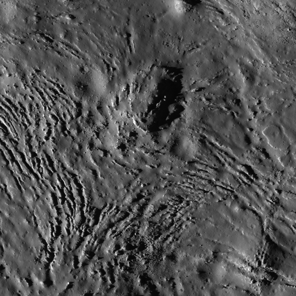
Fractures can be seen in profuse abundance on the Jackson crater melt pond surface. Illumination from west, a field of view roughly 700 meters across swept up at an incidence angle of 71.13° LROC Narrow Angle Camera (NAC) observation M118560367L, LRO orbit 2606, January 19, 2010; resolution 0.84 meters from 52.97 kilometers altitude. View the full-size Featured Image HERE [NASA/GSFC /Arizona State University].
James Ashley
LROC News System

As molten rock cools, it shrinks and often cracks. In this case of impact melt ponded within the Jackson crater floor (22.18°N, 197.24°E), the cracking rate was so high that unfractured melt is almost more of an exception than a rule!

Radial and divergent patterns can be seen among the fracture sets that tell a story of the cooling history. The context image below shows a portion of their wider distribution.

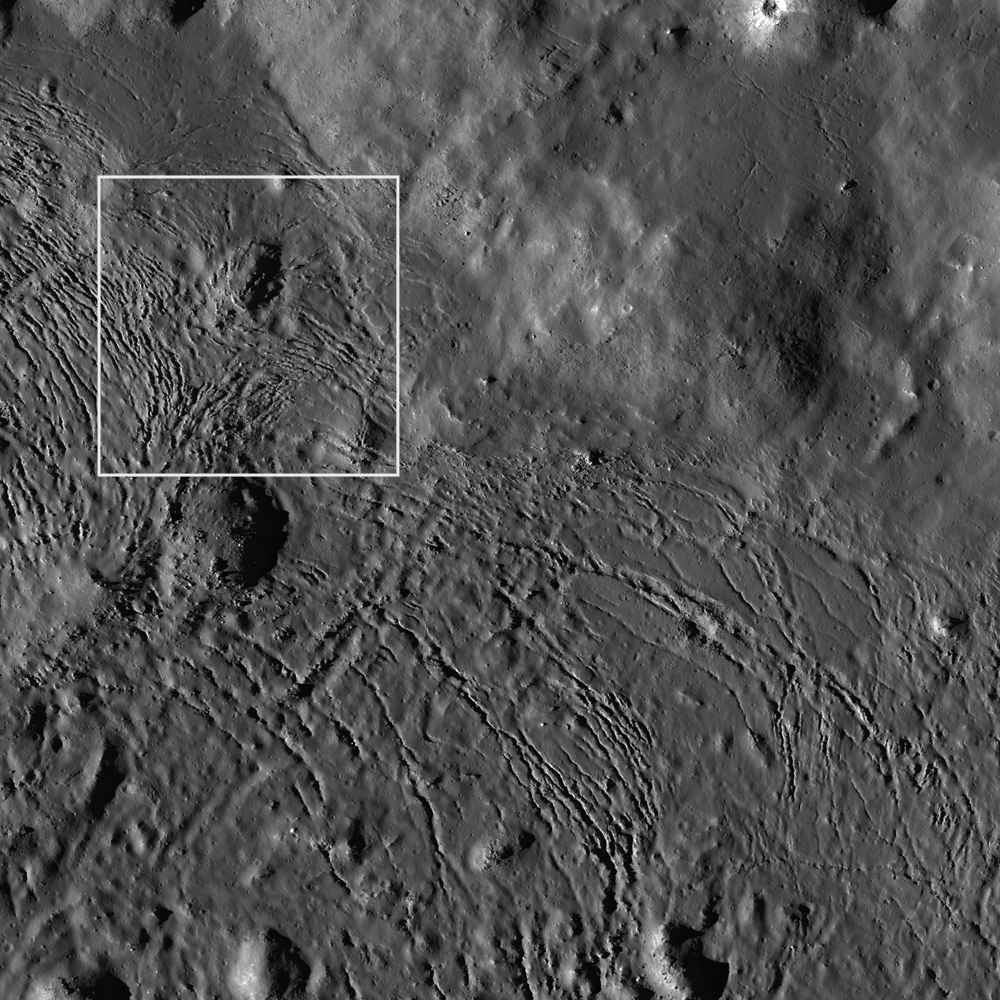
As context for the January 18, 2012 LROC Featured Image (field of view near where the impact melt inundating the crater floor emerges from eastern wall slump; the white box) a long view north and up the steep northeastern wall, nearly to the rim, courtesy of the digital elevation model combined in Google Earth [NASA/USGS/ASU/JAXA/Google].
Overhead context for Featured Image, a field of view roughly 2.5 kilometers across from the wider LROC frame.View the full-size LROC context image HERE [NASA/GSFC/Arizona State University].
Solid objects in the melt, together with the 'shore' of the pond, appear to have influenced the way the cracks organized themselves as the melt cooled. Note how the fractures bend around or radiate from some of the positive relief features in the images above. These could be ejecta blocks or portions of the slumped crater walls in the melt that served to locally accelerate cooling. Their influence might thus be to 'seed' the stress field within the shrinking melt volume, helping some of the cracking to grow from these points, and ultimately resulting in the patterns we see today. Sagging along the shore can cause the cracking to parallel the shoreline. Any motion within the volume of melt, possibly influenced by late-stage additions of molten material, may also have contributed to the patterns observed here.

Further context, from 100 kilometers altitude, this square crop from a highly detailed HDTV still frame was captured by Japan's lunar orbiter SELENE-1 (Kaguya) in 2009 [JAXA/NHK/SELENE].
The extent and complexity of the melt pond features can be explored in the full NAC frame HERE. Additional examples of impact melt cracking include Polygonal fractures on Tycho ejecta deposits, fractured impact melt in Thales crater, and Moore F.

Ed Note: In a way opposite and contributing to the low optical visibility of the vast majority of similarly sized craters in the farside Highlands, Jackson is easier for the eye to see than most. Like Tycho on the nearside, there are a lot of craters of similar size and origin everywhere on the Moon. The difference is age. Like Tycho, the ray system of Jackson (and the materials its progenitor impact threw out) shows Jackson's "optical immaturity." To illustrate, below are two representations of the farside quadrant with the highest of the Highlands scoured by the Jackson impact, likely less than a half billion years ago.

Jackson stands out in this global montage of Clementine (1994) Ultra-Violet/Visible (UVVIS) wavelength photography designed to better map the Moon's albedo, more than a decade ago. Similar craters, basins and the Moon's highest elevations are nearly invisible [NASA/USGS/DOD].

A white arrow is needed to designate Jackson out from the pocked highlands and several otherwise invisible basins stand out with exceptional clarity in this view of nearly the same terrain as a representation of differences in elevation from the LROC Global Digital Terrain Model, developed using LROC Wide Angle Camera survey photography [NASA/GSFC/Arizona State University].

Tuesday, September 27, 2011

The First Race to the Moon

Engineer Special Study of the Surface of the Moon (1960, 1961), "Generalized Photogeologic Map of the Moon" (Robert J. Hackman, USGS; Prepared for the Office, Chief of Engineers, Department of the Army, U.S.) [LPI, USGS].
David S. F. Portree
Beyond Apollo

The race to the moon began on August 17, 1958, and the Soviet Union won. This isn't the opening line of an alternate history story; rather, it is an acknowledgment that more than one moon race took place. The first, with the goal of launching a small automated spacecraft to the moon, began with the liftoff of the Able 1 lunar orbiter, a 38-kilogram U.S. Air Force (USAF) probe. (It was later redesignated Pioneer 0.) Just 77 seconds after launch from Cape Canaveral, Florida, Able 1's first-stage Thor rocket exploded, ending the world's first attempted lunar mission.

A month later, on September 23, 1958, the Soviet Union joined the race. A spherical Luna probe intended to impact the moon fell victim to the failure of its upgraded R-7 booster rocket just 93 seconds after liftoff from Baikonur Cosmodrome in central Asia.

On October 11, 1958, USAF launched Able 2, a near-copy of Able 1. It was the first lunar launch conducted under NASA auspices. The civilian space agency had opened its doors on October 1, 1958. NASA absorbed most Department of Defense space projects, though in practice the USAF and Army continued to carry out missions while interagency relations and lines of command became defined. Able 2, later redesignated Pioneer 1, burned up in Earth's atmosphere on October 13, after its Able second stage shut down early, placing it on an elliptical path that took it about a third of the way to the moon. The Soviets launched their second Luna moon impactor just 16 hours after the U.S. launched Able 2. The Luna's upgraded R-7 launch vehicle exploded 104 seconds after liftoff.

And so it went, with launches from Florida and Kazakhstan alternating and failing.

Read the Remarkable Chronicle HERE.

Monday, May 16, 2011

Online: The Lunar Mapping and Modeling Project (LMMP)


No longer 'no man's land,' the Moon's south pole and vicinity unseen before the 21st century swept up by laser altimetry over multiple orbital passes of the LOLA instrument on-board the Lunar Reconnaissance Orbiter (LRO). Most of the lower elevations shown above are permanently shadowed. This false-color and hill-shade view of the LOLA Digital Elevation Model (DEM) is a small example of what can now be very easily accessed on-line by way of the Lunar Mapping and Modeling Project (LMMP), already a very thorough public resource under development by NASA.

Kimberly Newton
Marshall Space Flight Center

NASA has created a new interactive web-based tool that incorporates observations from past and current lunar missions creating one of the most comprehensive lunar research websites to date.

The Lunar Mapping and Modeling Project at NASA's Marshall Space Flight Center in Huntsville, Ala. has created an online set of capabilities and tools that will allow anyone with an Internet connection to search through, view, and analyze a vast number of lunar images and other digital products. The data and tools available through the project website will allow researchers to perform in-depth analyses to support mission planning and system design for lunar exploration and science missions. It will permit detailed scientific analysis and discovery and open additional educational and outreach opportunities.

The project website is a one-stop location for finding, retrieving, and analyzing data about the moon, including the most recent lunar surface imagery, altimetry, temperature, lighting and other data, as provided by the Lunar Reconnaissance Orbiter (LRO) and its seven onboard instruments.


A postage-stamp-sized reduction of the LMMP user interface as viewed through most browsers shows the LOLA color-coded and hillside shaded elevation of 75 degrees south layered over, in this example, the LROC Wide Angle Camera (WAC) monochrome mosaic [NASA].

The orbiter, launched by NASA in 2009, continues to gather information about the moon from its orbit some 31 miles (50 kilometers) above the lunar surface. LRO has provided a treasure trove of data -- more than all previous lunar and planetary missions combined.

The Lunar Mapping and Modeling Project website will also include data obtained from past lunar programs and missions including Apollo, Lunar Orbiter, Lunar Prospector, Clementine, Kaguya (Japan) and Chandrayaan-1 (India).

Read the full-story HERE.


On the other hand, some lunar features can only be seen to be appreciated. As previously demonstrated, the Reiner Gamma lunar swirl, a nearside landmark in Earth-side telescopes, is invisible in the LMMP LOLA DEM layer, but shows up instantly when, with a click of the mouse, the present LMMP base map Lunar Orbiter/Clementine hybrid photomap is brought to the surface.