Showing posts with label Google Earth. Show all posts

Friday, January 20, 2012

LROC Melt fractures in Jackson crater

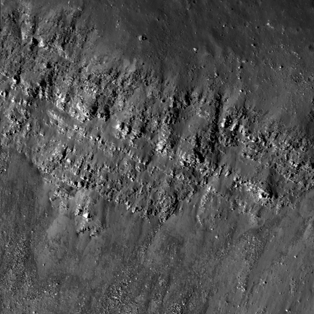
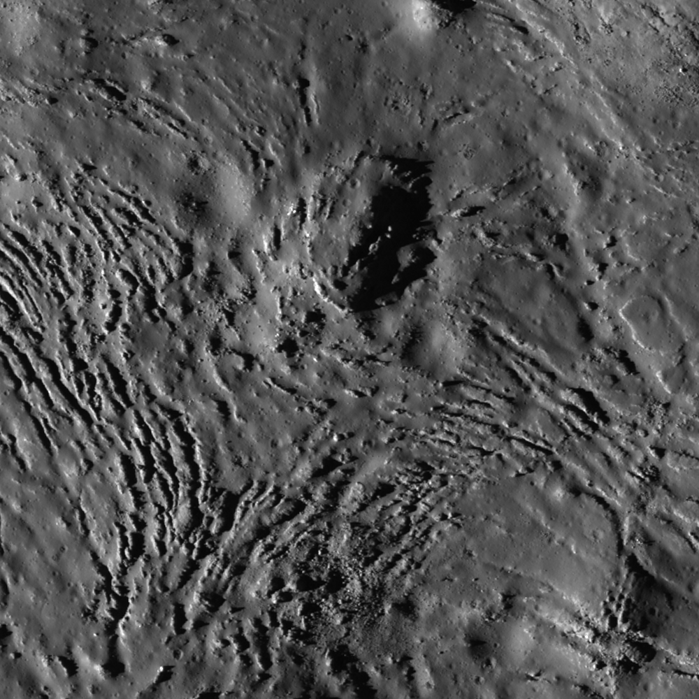
Fractures can be seen in profuse abundance on the Jackson crater melt pond surface. Illumination from west, a field of view roughly 700 meters across swept up at an incidence angle of 71.13° LROC Narrow Angle Camera (NAC) observation M118560367L, LRO orbit 2606, January 19, 2010; resolution 0.84 meters from 52.97 kilometers altitude. View the full-size Featured Image HERE [NASA/GSFC /Arizona State University].
James Ashley
LROC News System

As molten rock cools, it shrinks and often cracks. In this case of impact melt ponded within the Jackson crater floor (22.18°N, 197.24°E), the cracking rate was so high that unfractured melt is almost more of an exception than a rule!

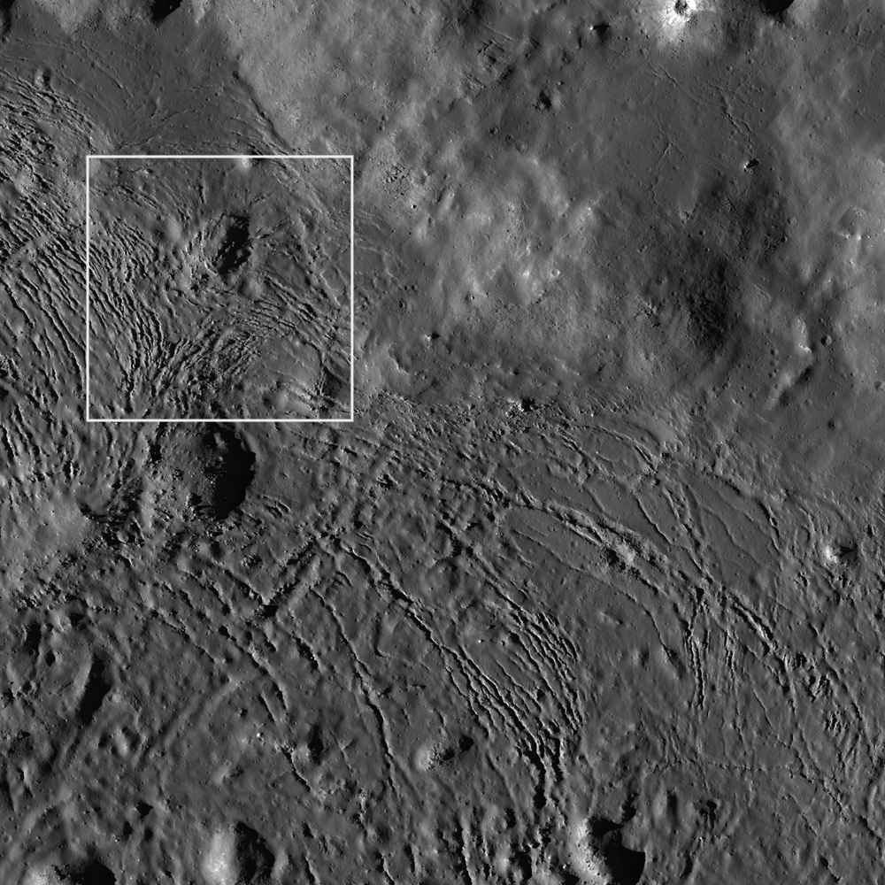
Radial and divergent patterns can be seen among the fracture sets that tell a story of the cooling history. The context image below shows a portion of their wider distribution.

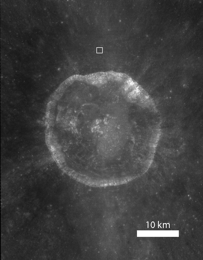
As context for the January 18, 2012 LROC Featured Image (field of view near where the impact melt inundating the crater floor emerges from eastern wall slump; the white box) a long view north and up the steep northeastern wall, nearly to the rim, courtesy of the digital elevation model combined in Google Earth [NASA/USGS/ASU/JAXA/Google].
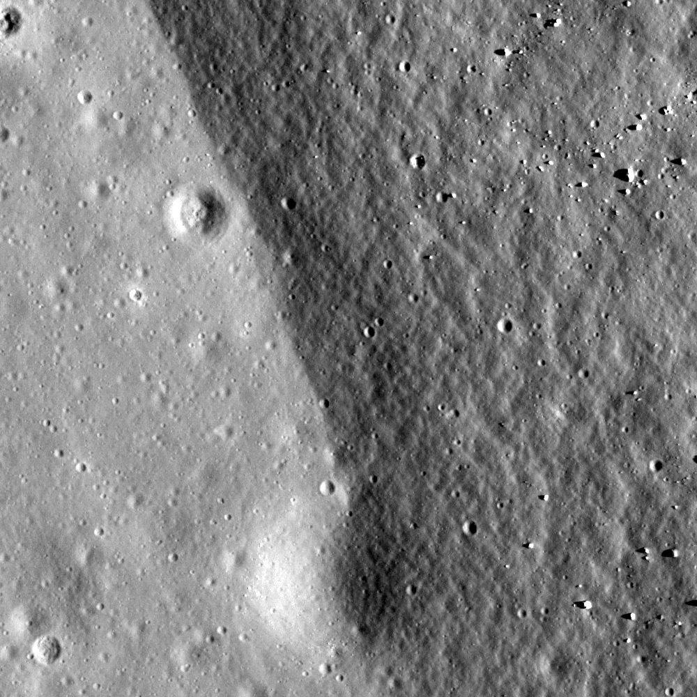
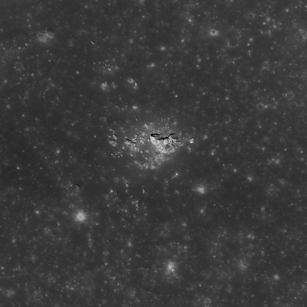
Overhead context for Featured Image, a field of view roughly 2.5 kilometers across from the wider LROC frame.View the full-size LROC context image HERE [NASA/GSFC/Arizona State University].
Solid objects in the melt, together with the 'shore' of the pond, appear to have influenced the way the cracks organized themselves as the melt cooled. Note how the fractures bend around or radiate from some of the positive relief features in the images above. These could be ejecta blocks or portions of the slumped crater walls in the melt that served to locally accelerate cooling. Their influence might thus be to 'seed' the stress field within the shrinking melt volume, helping some of the cracking to grow from these points, and ultimately resulting in the patterns we see today. Sagging along the shore can cause the cracking to parallel the shoreline. Any motion within the volume of melt, possibly influenced by late-stage additions of molten material, may also have contributed to the patterns observed here.

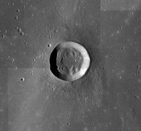
Further context, from 100 kilometers altitude, this square crop from a highly detailed HDTV still frame was captured by Japan's lunar orbiter SELENE-1 (Kaguya) in 2009 [JAXA/NHK/SELENE].
The extent and complexity of the melt pond features can be explored in the full NAC frame HERE. Additional examples of impact melt cracking include Polygonal fractures on Tycho ejecta deposits, fractured impact melt in Thales crater, and Moore F.

Ed Note: In a way opposite and contributing to the low optical visibility of the vast majority of similarly sized craters in the farside Highlands, Jackson is easier for the eye to see than most. Like Tycho on the nearside, there are a lot of craters of similar size and origin everywhere on the Moon. The difference is age. Like Tycho, the ray system of Jackson (and the materials its progenitor impact threw out) shows Jackson's "optical immaturity." To illustrate, below are two representations of the farside quadrant with the highest of the Highlands scoured by the Jackson impact, likely less than a half billion years ago.

Jackson stands out in this global montage of Clementine (1994) Ultra-Violet/Visible (UVVIS) wavelength photography designed to better map the Moon's albedo, more than a decade ago. Similar craters, basins and the Moon's highest elevations are nearly invisible [NASA/USGS/DOD].

A white arrow is needed to designate Jackson out from the pocked highlands and several otherwise invisible basins stand out with exceptional clarity in this view of nearly the same terrain as a representation of differences in elevation from the LROC Global Digital Terrain Model, developed using LROC Wide Angle Camera survey photography [NASA/GSFC/Arizona State University].

Tuesday, December 27, 2011

More LROC close-ups from August

LROC Narrow Angle Camera (NAC) "footprints"
narrowed to those unprecedentedly low (25 km)
altitude observations gathered last August, seen
here in Google Earth.
Joel Raupe
Lunar Pioneer

Since the 8th 'tri-monthly' Data Release by teams flying instruments on-board LRO on December 15 we've been rushing to sample the latest set of LROC Narrow Angle Camera (NAC) footprints to discover what's new.

After downloading the newly-updated NAC and WAC footprint KML's for viewing with the Google Earth program (through the Planetary Data System (PDS) the first temptation is to try to take it all in. But that's like examining every square nanometer of a basketball with a microscope. So we tried, once again, to begin instead by taking note of new NAC observations of our ever-growing list of favorite targets.

And yet, this latest release was more highly anticipated than any since the Commissioning became the Nominal LR mission in late 2009. Before being redeployed to a more fuel efficient higher orbit in January, last August flight directors reduced the spacecraft's orbital perilune to within 25 kilometers for a brief time. This made possible an even closer examination of three of the six Apollo landing sites, the subject of a NASA news conference in September.

What wasn't generally discussed at the time, however, was what else might have been photographed at 40 centimeters per pixel resolution and greater last August.

Most of the full width of LROC Narrow Angle Camera (NAC) observation M168570575R, orbit 9976, August 21, 2011; incidence angle 37.14° with an original resolution of 0.3994 meter per pixel from 23.98 kilometers. The white rectangle is the smaller field of view shown at the original resolution in the image immediately below. At this low altitude, where LRO was flown for only a brief time last August, it's necessary to step back quite a long way to appreciate the context, in this case a north-south 1000 meter-wide cross-section of the unofficially named "Sinuous Rille A" feature in the Marius Hills region of Oceanus Procellarum [NASA/GSFC/Arizona State University].
The boulder-shedding southern edge of "Sinuous Rille A" as viewed from only 24 kilometers above on August 21, 2011. The original layering of the the surrounding greater Procellarum basin as excavated by more "recent" flows from the Marius Domes is clearly exposed. The smallest features distinguishable are only 40 centimeters in size. The first of the "pit craters" discovered on the Moon here by Japan's Kaguya orbiter team in 2009 is located elsewhere on the floor of this rille. (Field of view only 230 meters) [NASA/GSFC/Arizona State University].
We've been pouring over those images, many of which can be seen using LROC web-based tools, since December 15. A first look seemed to show a rather haphazard, seemingly thin set of targets, taking advantage of a daylight perigee over the equator, in mid-August, with a few exceptions, like the Ina caldera, which stood out enough for us to have taken note of it in a post last week. Over Christmas weekend, as we began collecting notes about what stands out in these low altitude NAC frames from August, LROC principal investigator Mark Robinson posted "Aristarchus Spectacular," featuring a breathtaking mosaic of that landmark nearside crater's bright interior from late in the low altitude orbital maneuver. (We hastily added a few snips to our mirror post that we had already collected showing the same area in even higher resolution taken from an August close-up).

To appreciate the volume of data in dire need of crowd sourcing the basics are worth repeating: According to the December 22 announcement, by LROC investigator Ernest Bowman-Cisneros, "(t)he 8th LROC Planetary Data System (PDS) release includes images acquired between 16 Jun 2011 and 15 (Sept.) 2011" including "83,010 EDR images totaling 8.5 Tbytes and 83,010 CDR images totaling 17 Tbytes... To date, the LROC team has released a total of 586,217 images (EDR) totaling 64.7 Tbytes. The complete LROC PDS archive can be accessed via the URL http://lroc.sese.asu.edu/data/."

Context: Color LROC WAC Digital Terrain Model (DTM) 64, showing the location of a massif pictured below, just outside the central ring of mountains surrounding the deep interior basin of Mare Orientale. The area was imaged at unusually low altitude by both NAC and WAC LROC cameras last August, around the time of the now-seasoned orbiter's unprecedented 10,000th orbit around the Moon [NASA/GSFC/Arizona State University].
The LROC Wide Angle Camera (WAC) was along for the ride last August, when LRO's orbit was briefly lowered to within a 25 kilometer perigee. On August 21 LROC swept up this 4000 meter-high massif just beyond the northeastern interior of Mare Orientale (9.5°S, 91.64°W), seen here in a mosaic at 604 nm from three sequential passes averaging 33.4 kilometers above. The resolution averages around 48 meters per pixel [NASA/GSFC/Arizona State University].
A bit of cutting and pasting allowed the filling in of this LROC NAC footprint (M168808506L and R) in three dimensions. The area within the white square is detailed below [NASA/GSFC/Arizona State University].
The very steep slope of the unnamed massif blown up to 2 meter per pixel resolution does little justice to the original. LROC NAC M168808506R, orbit 10011, August 20, 2011; illumination incidence angle 32.96° with a raw resolution of 44.2 centimeters per pixel from 33.2 kilometers [NASA/GSFC/Arizona State University].
At full resolution, the boulder and it's interrupted trail down the south face of the massif show signs of space weathering. It's by no means the most spectacular feature in the August lower altitude NAC frames [NASA/GSFC/Arizona State University].
It's a lot of data to sort through, yet again breaking LRO's own already well-established record for having returned more data from deep space than all of mankind's probes sent beyond low Earth orbit put together.

There are boulder trails, to be sure, and though it may be only our imagination but there seems to be more than a random share of small, bright impact craters in the set. The best candidate for the impact crater formed by the Apollo 15 lunar module ascent stage, for example, was swept up yet again. As we begin to sort out our notes in greater order we look forward to posting better examples from this unique set. Like every other lunatic following LRO's steady progress we look forward to seeing and reading what Robinson's LROC team at Arizona State has uncovered in these frame also.

Now that's an interesting boulder trail! From only 23 kilometers overhead, a chunk of ring-bound upthrust the size of a passenger trail locomotive has rolled down and pitted this shallow incline near the dead center of Mare Serenitatis. The August "close-up window" enjoyed briefly by LROC's NAC system seems to have had its advantages centered on the nearside longitudes and just beyond either limb. LROC NAC M168081909R, LRO orbit 9904, August 15, 2011; incidence angle 46.74° with a resolution of 39 cm per pixel from 23.06 kilometers [NASA/GSFC/Arizona State University].
Related Posts:
LRO sweeps down for a closer look at Apollo sites
August 13, 2011
Low-altitude views of Apollo released
September 3, 2011
LRO Briefing: Latest close-ups of Apollo sites
September 6, 2011
Skimming the Moon
New views of Apollo 12
Apollo 14 at 25 cm per pixel
On the rim!
September 8, 2011

Monday, November 21, 2011

Apollo Metric Camera maps completed

The final three Apollo "J" missions as planned were devoted to science, and each of their Service Modules were equipped with an array of equipment that remained in orbit as their surface expeditions were carried out. Mapping Metric and Panorama Cameras operated over the sunlit surface over multiple orbits as part of the Apollo 15, 16 and 17 missions. Film canisters for these cameras were retrieved in spacewalks during the long cruise home. Until recently, the orbital corridors under the orbital plain of these last missions were the most well-understood detailed portions of the lunar surface [NASA/Google Earth].
Dr. Terry Fong
Director, Intelligent Robotics Group
NASA Ames Research Center

It gives me great pleasure to announce the release of the "Apollo Zone" Digital Image Mosaic (DIM) and Digital Elevation Model (DEM). These maps cover approx. 18% of the Lunar surface at a resolution of 1024 pixels per degree (approx 30 m/pixel). The maps are the result of 3 years worth of work by the NASA Ames Intelligent Robotics Group (IRG) to align and process more than 4,000 images from the Apollo Metric Camera (AMC), which flew aboard Apollo 15, 16, and 17. The AMC images were provided by the Apollo Image Archive at Arizona State University.

To preview the "Apollo Zone" maps, download the following "KML" file for viewing in Google Earth:

http://byss.ndc.nasa.gov/stereopipeline/dataviz/apollo_metric.kml

Once you open that file in Google Earth you will have options to view these "Apollo Zone" maps overlaid on Google Earth's "Moon mode". The full maps (in GeoTIFF format with complete metadata) have also been uploaded to the Lunar Mapping and Modeling Project (LMMP) portal (http://lmmp.nasa.gov) and will soon be available for visualization and download via that site.

The "Apollo Zone" maps cover the following sites of interest: Apollo 15, Apollo 16, Alphonsus Crater, Rima Prinz, Aristarchus Plateau-2, Ina D Caldera, Sulpicius Gallus, Mare Crisium, Mare Smythii, King Crater, Tsiolkovskiy Crater, Aitken Crater, and half of Van de Graaf Crater.

The terrain model has an average vertical accuracy of 40 m/pixel and standard deviation of 37 m (compared to LOLA laser altimetry tracks). Over 46% of the covered surface has vertical errors lower than 25 m.

The "Apollo Zone" maps (image, elevation, hillside, colorshade, confidence and precision) were automatically generated using new computer vision algorithms developed by IRG:

 - robust statistical sub-pixel stereo correspondence
 - robust bundle adjustment and radiometric corrections for large-scale
   image mosaics
 - orbital camera position/orientation estimation using interest point
   extraction
 - photometric correction of exposure time, shadow removal and generation of
   seamless large-scale image mosaics.
 - photometric method for reconstructing lunar albedo
 - photoclinometric terrain reconstruction method that improves lunar
   DTM precision
 - statistical method for multiple stereo digital terrain model mosaicking
 - multi-view 3D terrain reconstruction
 - DTM / LOLA alignment and lidar / image matching

These algorithms have been released as NASA open-source (Ames Stereo Pipeline, Neo-Geography Toolkit, and NASA Vision Workbench). Map processing was performed using the NASA Pleiades supercomputer. In addition to the Apollo Metric Camera images, the fully automatic map processing pipeline has also been used with data from the Lunar Reconnaissance Orbiter Camera (LROC) and by several planetary science groups.

This work was funded by the Lunar Mapping and Modeling Project (LMMP). We gratefully acknowledge the support of our collaborators at NASA MSFC, NASA GSFC, JPL and USGS. We sincerely thank Mark Robinson and the Apollo Image Archive at ASU for restoring and bringing the AMC data to "digital life". Our special thanks go to Ray French and Mark Nall for their support and leadership of LMMP.

If you have any questions, or would like more information, please let me know.

Cheers,

Terry Fong

Wednesday, November 2, 2011

Tycho's flash-frozen inferno

Tycho in a full Sun, 'low phase' illumination, the crown jewel of a Full Moon on Earth has only its relative youth to distinguish it from many similarly-sized craters of similar origin. - LROC Wide Angle Camera (643 nm) mosaic from seven orbital passes (9061 - 9067) June 11, 2011. Arrow marks location of terraced pools of impact melt detailed below [NASA/GSFC/Arizona State University].
Joel Raupe
Lunar Pioneer, LLP

Hardly rare in scope or origin from similar craters all over the Moon, Tycho stands out like a bright star in the nearside southern Highlands because its bright rays radiate outward over the face of an entire Full Moon. Those rays make Tycho visible to the naked eye on Earth.

At a youthful 109 million years of age, relentless gardening by micrometerors has not yet smoothed the crater's reflective rougher edges, nor has a never-ending rain of charged particles, from the Sun and beyond, merged it's coloration into the background.Later impacts have not superimposed themselves or covered over the flash-frozen record of the mere minutes and hours following the explosive release of kinetic energy that created Tycho.

Tycho under 'high phase' illumination, at sunrise shows it's elevations in stark contrast, without the blinding albedo that tends to blur the immediate area of impact into the much broader area affected by that impact. LROC WAC mosaic, with longitude and latitude lines released by the LROC team last July. The impact melt detailed below, pooled just beyond the southeastern rim in this 130 kilometer-wide field of view, is much easier to see in the full-size original LROC image release, available HERE [NASA/GSFC/Arizona State University].
Among these finer details retained by Tycho are the pools of impact melt on the inner terraces and not far outside the crater's high rim, like the 'paved' pond Surveyor 7 nearly landed on in 1968, seen in the stark beauty of LROC Narrow Angle Camera observations.
The progenitor, the object that struck the lunar highlands and created Tycho threw up a lot of material in those first seconds afterward. Some of this material sped away at escape velocity, casually returning to the surface much later, if ever. Some sped away laterally as an immediate shock wave, carrying with it enough force to clip the tops of mountains on the south edge of Mare Serenitatis, knocking down the bright material of the Tortilla Flats in Taurus Littrow, sampled by Apollo 17 in 1972.

Some of the cloud scooped up by the blast hesitated above the area from where it was lifted and piled back down onto the surface outside the molten scar but most of the height where Tycho formed had to have been there before the explosion. We can tell this from the deep rutted channels carved into the highlands for hundreds of kilometers away from its center. The shape of the lunar surface around Tycho is not defined by what piled up but what remained after thousands of square kilometers of material were gouged away.

Tycho seems nested in a kind of plateau, though the evidence appears to show that this plateau was defined out of the highlands by the impact event that created Tycho. Great three and four kilometer-deep gullies appear to have been scooped out and away by the blast, better seen in this virtual 3D oblique view looking north over the outer southeastern rim of Tycho. LROC WAC (643 nm) mosaic as an overlay upon the Kaguya (SELENE-1) lunar digital elevation model in Google Earth [NASA/GSFC/USGS/JAXA/Arizona State University/Google].
The terraces on the inner walls of Tycho became a place for impact melt to pool and cool, so the terraces, by and large, were unlikely to have been formed by later slumping. We're left with a picture, immediately after the Tycho impact event, of a ragged scar, glowing hot in those first hours, from the central peak of deeper rock that rebounded in a heap (never higher than a crater's rim) to the very lip of the outer rim. It must have been a scene right out of Dante's Inferno.

LROC Wide Angle Camera (WAC) monochrome (643 nm) observation M119950214M, LRO Orbit 2810, February 4, 2010; resolution 66.12 meters per pixel, incidence angle 64.73° from 47.55 km. The yellow rectangle roughly outlines the field of view within the entire from of the LROC Narrow Angle Camera (NAC) frame from which scenes following originated [NASA/GSFC/Arizona State University].
Zooming in on these "Southeast Tycho" impact melt ponds, in the images above and following, note the fan of these ponds seem to flow downhill from a particularly ragged spot on the rim and apparently from further north channeled from an less distinct portion of the circumference of Tycho's rim. It's hard to imagine Tycho filled to the "brim" with molten rock, though the original melt was probably higher before it solidified to its present level. 

It's easier to imagine very hot material briefly pasted on the inside walls of Tycho sliding down to pool and form the ponds on the inner wall terraces. The ponds on the outside of Tycho are relatively sparse, but so is the slope acreage elevations outside the crater's interior. Before the anatomy of Tycho cooled and hardened some of the hottest melt was slung high seems to have collapsed like the opening rip of an ocean wave, which quickly froze, liquid rock that fossilized forty million years before the KT Boundary Extinction event brought an end to the Age of Dinosaurs here on Earth.

As impact melt briefly ran down the exterior side of the southeast brim of Tycho and pooled, coming to a halt in the cold vacuum of space long before 'finding its own level,' what appear as grooves formed by flowing molten material appear closer in to be shattered rock that instead merely aided molten transport. LROC NAC observation M150578086R, LRO Orbit 7324, January 25, 2011; resolution 71 centimeters per pixel, incidence angle 69.84° from 44.74 kilometers [NASA/GSFC/Arizona State University].
Full resolution view of the pond shore at the upper northeast in the image immediately above. The impact melt that ponded here briefly 109 million years ago was still hot enough for gas trapped within to heave bubbles to its surface. The flow at this juncture was arriving from all direction and the rounded surface tension elsewhere testifies to the lava-like viscosity of the pond [NASA/GSFC/Arizona State University].
A second full-resolution view from LROC NAC M150578086R shows where melt from the Tycho event briefly flowed down a huge, powerful fall at a high slope between ponds more than a thousand meters apart in elevation [NASA/GSFC/Arizona State University].
Tycho may be the same as many other craters on the Moon, but it's relative youth "in Moon years" makes it an easy choice for mapping the immediate aftermath of a powerful impact on an airless body, at least for the next half billion years or so.

Related Posts:
Tycho Peak Spectacular!
Chaotic crater floor in Tycho
Polygonal fractures on Tycho ejecta
Impact melt on Tycho floor
Ejecta on Tycho floor

LROC: Fissures and Pit Chains

Fissures and associated pit-chains on the east floor of farside landmark crater Aitken (16.4°S, 173.4°E). LROC Narrow Angle Camera (NAC) M128148929L, LRO Orbit 4018, May 10, 2010 from 55.5 km; incidence angle 44.72° (resolution 58 cm, image field of view width ~336 meters. View the full size LROC Featured Image HERE [NASA/GSFC/Arizona State University].

Hiroyuki Sato
LROC News System

Aitken crater (16.4°S, 173.4°E) is a 135 km diameter crater located very near the center of the farside. Its floor is covered by low-reflectance materials, most likely post-impact lava flows. The eastern edge of the floor is disrupted by an irregular shaped wrinkle ridge that extends in a north-south direction.

Today's Featured Image is about 3.5 km west of the ridges. Here there are parallel linear fissures aligned in NW to SE direction. Pit-chains are located along the fissures, which are likely caused by mass wasting into the subsurface void space.

The largest pit is in the center of the image and shows a relatively rough bottom compared to the surrounding smooth surface. One might expect a small pit like this to be quickly filled by debris from impacts and moonquakes. But this hole seems fresh, which implies a relatively young age.

A virtual oblique view of the western interior of Aitken demonstrating the relative size of the western crater wall, towering over the region of interest. LROC Wide Angle Camera (WAC) 604 nm mosaic, from May 27, 2011, is seen projected on the lunar digital elevation model available to users of the Google Earth application. The rectangle represents the roughly 2900 meter-wide field of view of LROC NAC observation M128148929L [NASA/GSFC/Arizona State University/USGS/Google].

Explore these fissures and pits in the full detail NAC frame yourself!

Related posts:
Extensional Fractures
Tectonics in Mare Frigoris
Stress and pull
Relative age relationships

Thursday, September 29, 2011

Descent of Apollo 11, DAC film compared with LROC NAC using Google Earth lunar digital elevation model

HT to Phil Platt and Scott Hall, Uploaded to YouTube by May 26, 2011.
 
"You can download my Google Moon KMZ file for import into Google Moon HERE," GTP writes. And "here is the link to my Apollo web site: http://apollo.mem-tek.com."

"Footage from the Eagle's movie camera has been matched to deconvolved and/or enhanced versions of Lunar Reconnaissance Orbiter image M116161085 (left and right NAC image pairs) which were taken by the LRO on December 22, 2009. Google Moon does not have a roll angle feature which would be useful for rolling the point of view. Additionally, Google Moon's digital elevation model is not of a fine enough resolution in order to precisely model the terrain. Thus some of the Google Moon screen captures of the overlaid LRO image may not precisely match the view from the Eagle's video camera."

Wednesday, April 20, 2011

Lava Flows Exposed in Bessel Crater


Spectacular example of layering exposed just inside the rim of Bessel (21.8°N, 17.9°E), a familiar 17 kilometer-wide nearside crater in Mare Serenitatis. LROC Narrow Angle Camera (NAC) observation M135073175R, field of view above is 500 meters; LRO orbit 5029, July 29, 2010; solar incidence 13° See the Full-Size LROC Featured Image, HERE [NASA/GSFC/Arizona State University].

Sarah Braden
LROC News System

The outcrops exposed on the interior wall of Bessel crater (~16 km in diameter) are remarkable since they are most likely preserved layering of mare basalt. Today's Featured Image shows a portion of the northern wall, which contains multiple layers that probably represent discrete lava flow deposits in Mare Serenitatis. Over time, large, but relatively thin, lava flows spread across the extent of Mare Serenitatis.

Lunar pits imaged by LROC also give us a good look at basalt flow layers. Boulders broken off of the mare layers tumble down the wall toward the floor of the crater.

Bessel crater is named after Friedrich Bessel, the developer of Bessel functions. By measuring the thickness of layering found in Bessel and other craters, scientists can put constraints on the thickness of individual lava flows. What else can Bessel crater tell us about Mare Serenitatis?


The original LROC Wide Angle Camera (WAC) 100 meter/pixel monochrome mosaic context image is seen here draped over the high-resolution Digital Terrain Model of the Apollo science mission corridor, available to users of Google Earth. Over that the LROC NAC frame was added (along with the Featured Image, barely visible inside the northwest rim. Bessel's interior shows slumping of material from the walls onto the floor [NASA/GSFC/Arizona State University].

Explore the entire NAC frame!

Related images:
Linne Crater
Dark streaks in Diophantus crater
Kepler's Rim


The view from the northwest floor (actually standing on slumped material) gazing up more than a kilometer along the longitudinal length of LROC NAC frame M135073175R and the location of the LROC Featured Image, almost to the crater rim (beyond line of sight). The Apollo Corridor was photographed in detail during the final Apollo "J" science missions, allowing for an assembly of a detailed terrain model, a method now being applied to the entire Moon by the LROC, LOLA and other instrument teams operating the Lunar Reconnaissance Orbiter.


Hopping digitally up to the rim of Bessel for a view south to the opposite rim, from a vantage near the location of the Featured Image. Similar lava layers are exposed at the same height 16 kilometers away. The southern Mare Serenitatis spreads out beyond. Examining LROC photography in this way demonstrates the global potential of the vast data being still being collected by LRO science teams, already many times over more information than all previous deep space missions combined.

Thursday, April 7, 2011

Interior Rim of Flamsteed P


Boundary of buried crater rim and mare basalt at Flamsteed P, Illumination is from west at an angle of 60°, field of view is 500 meters; from LROC Narrow Angle Camera (NAC) observation M114233793R, LRO orbit 1968, November 30, 2009. View the full-size Featured Image, HERE. [NASA/GSFC/Arizona State University].

Hiroyuki Sato
LROC News System

Today's Featured Image displays a portion of eastern rim of Flamsteed P crater, located in southern Oceanus Procellarum. The rough and darker right side corresponds to the rim slope, and the brighter and smoother area to the left is the younger mare basalt. Flamsteed P's interior was mostly filled by mare basalts and all that remains are portions of its rim showing as discontinuous ridges (see WAC context image below).

In terms of local timeline of events (geochronology), following the formation of Flamsteed P, mare basalt flooded its interior and exterior. Later a small crater (110 m diameter) formed just at the boundary between the mare and crater rim (bottom of today's Featured Image). This small crater is half covered by the older rim unit. Does this make sense? Even though the small crater is much younger than the Flamsteed P rim it is buried by rim materials that slid downhill after the crater formed. What cause the regolith to move? Perhaps moonquakes generated by internal stresses or nearby impact events. Or perhaps a slower process of downhil creep caused by thermal cycling of the regolith (soil). We have much to learn about the Moon - the next frontier!


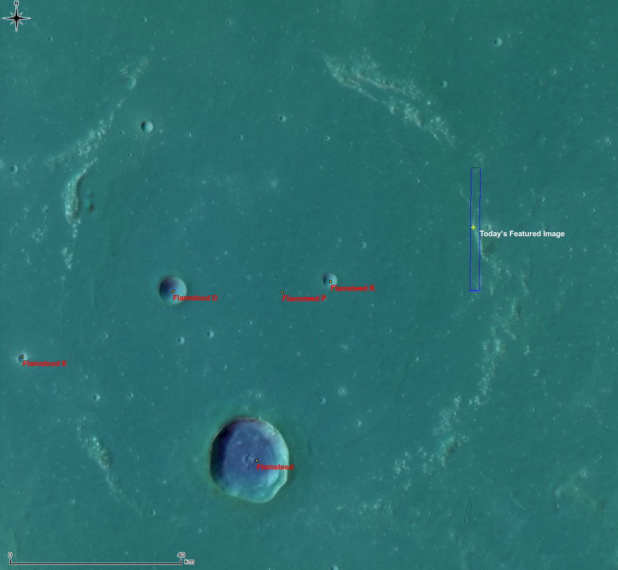
Whole of Flamsteed P, yellow cross and blue rectangle indicate the locations of the April 6, 2011 LROC Featured Image and the NAC frame from which is was taken. False color image from the Digital Terrain Model (DTM) centered at 3.15°S, 315.96°E. A LROC Wide Angle Camera (WAC) mosaic at 100 meters per pixel resolution is overlaid by LROC WAC DTM at 500 meters per pixel. View the full-size context image HERE [NASA/GSFC/Arizona State University/DLR].

The topographic color was produced as a by-product of stereo analysis of the WAC global dataset. Producing the global Digital Elevation Model (DEM) is a big job being led by LROC team members at the German Aerospace Center (DLR; English version) in Berlin.


Flamsteed P also hosts the first United States spacecraft to soft-land on another world, on June 2, 1966. The sentinel Surveyor 1, visible in this illusion of a 500 meters high "flyover" of LROC NAC images of the spacecraft's shadow on the ancient mare-inundated crater's interior. The northern rim of Flamsteed P is just apparent on the horizon [Google Earth/NASA/USGS/GSFC/Arizona State University].

Explore the boundary of mare basalts by viewing the full NAC frame!

Related posts:
Archimedes - Mare Flooded Crater
Wrinkle Ridges in Aitken Crater
Volcanoes in Lacus Mortis
Relative Timing of Geologic Events in Mare Frigoris
Surveyor 1 - America's first soft lunar landing


This 15 percent reproduction of a 6100 x 8200 mosaic from 43 individual images from Astronominsk hardly does it justice. You own it to yourself to see the original, captured in August 2010, just to see if you can locate Flamsteed P, a familiar target for even modestly-equipped amateurs [Goryachko, Abgarian & Morozov, Minsk, Belarus].


And here's the line-of-sight view of Flamsteed P as seen from Earth, not close-up but at full-resolution from the Astronominsk. The contact zone between the eastern rim of the nearly buried 100 kilometer-wide crater, discussed in the LROC Featured Image, can be spotted with little effort [Goryachko, Abgarian & Morozov, Minsk, Belarus].

Tuesday, November 9, 2010

Kepler Crater Ejecta


Large boulder ejected from Kepler crater, a small depression from the boulder's impact is just visible. LROC Narrow Angle Camera (NAC) observation M140155410L, LRO orbit 5788, September 26, 2010; above field of view is 320 meters, original LROC featured image (here) 800 meters [NASA/GFSC/Arizona State University].

Drew Enns
LROC News System

Kepler is a Copernican aged crater (32 km diameter, 8.1°N, 322.0°E) named for the German Astronomer Johannes Kepler, famous for his three laws of planetary motion. The impact event that created Kepler crater was energetic enough to eject this 100 m boulder out onto its continuous ejecta blanket. Impact events excavate material from great depth (approximately 1/3 the transient crater diameter) and distribute the material around the crater as ejecta. The material at the top of the impacted surface is ejected the furthest, while the deepest material has just enough energy to land on the crater rim. This distance to depth relation creates a natural core sample for astronauts to collect as they explore.


LROC Wide Angle Camera (WAC) context image of Kepler showing the location of the boulder field north of the crater on the downward slope of its ejecta blanket [NASA/GFSC/Arizona State University].


Kepler when the Moon is full, or how the optical immaturity of it's surroundings betray its relative youth in this spectacular photograph by P. Van de Haar of the Netherlands. This is how this familiar near side crater appears through modest telescopes at local "high noon."


In November 1969 the crew of Apollo 12 had a landing transfer orbit with a perilune further west than any other of the Apollo surface expeditions, and as such apparently captured the best images of Kepler prior to LRO, forty years later. The view of Kepler, 557 km northeast of the Apollo 12/Survey 3 landing site, had to have been captured late in the mission [NASA/LPI].


A center slice of a wider wallpaper-sized view of Kepler, looking south from a virtual vantage over the featured boulders, peeking over the north rim across Kepler to the south rim 40 km beyond [NASA/GSFC/Arizona State University/Google Earth].

The lunar mare were formed as old impact basins filled by massive eruptions of very fluid basalt. Its easy to measure the area of these mare basalts, but how thick are they? Are there multiple basalt flows that form the mare? If the mare is thin enough the Kepler impact may have excavated both mare and the underlying highland material. Samples from this boulder, and others like it out to the edge of ejecta could answer these questions. An astronaut would start sampling at the far edge of the ejecta blanket and work towards the rim. During this traverse the intrepid geologist would in effect be traveling down the inside of the crater, without doing all the work of climbing in and out! The last sample on the rim would be from near the bottom of the crater. With this suite of samples the history of the emplacement of the basalts at this spot could be unraveled.

Search for other ejecta boulders in the NAC image!

Related Posts:
Ejecta from Van de Graaf Crater

Saturday, July 11, 2009

Google may unveil 3D Moon Mapping tool

J.R. Raphael PC World

"The gang at Google is preparing to embark on some new type of mission, and speculation is running rampant that it's going to be a groundbreaking three-dimensional moon-mapping utility. The G-team is keeping quiet for now, but it's not hard to track the signals and see why the moon's on everyone's mind."

"You can largely thank Buzz for all the Google moon map buzz. Google's press department sent out invitations to reporters this week describing a media event at which famed astronaut Buzz Aldrin will be speaking. The event is described as "a very special announcement about the newest addition to Google Earth" -- oh, and it's scheduled for July 20."

Read the article HERE.