Showing posts with label Tycho. Show all posts

Wednesday, February 18, 2015

Hell Q

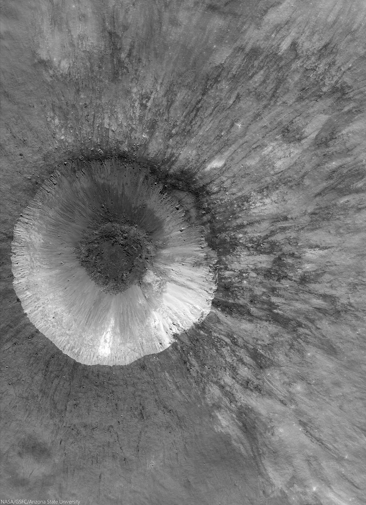
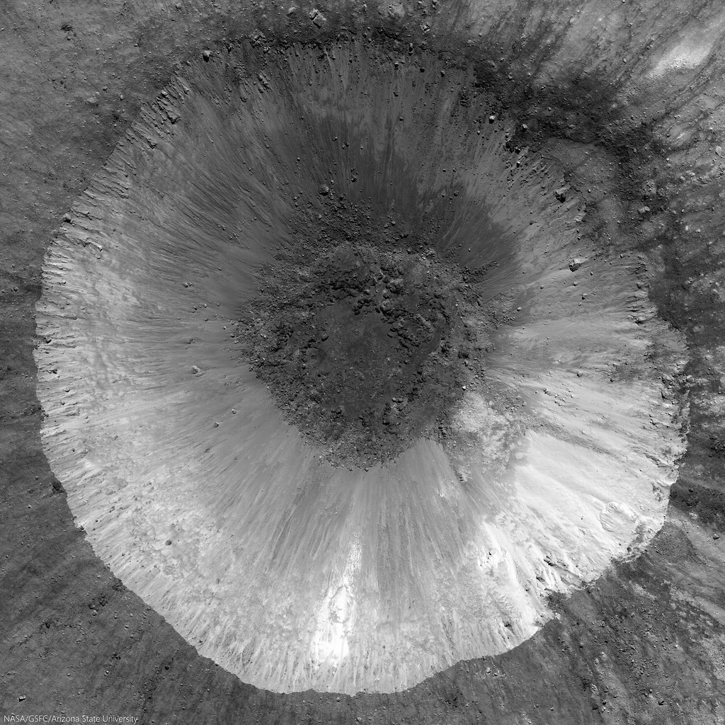
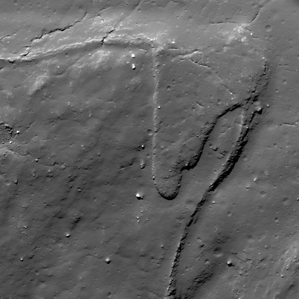
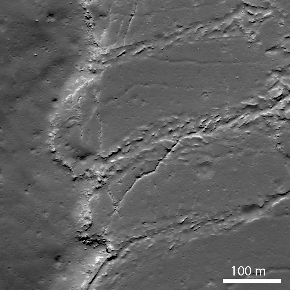
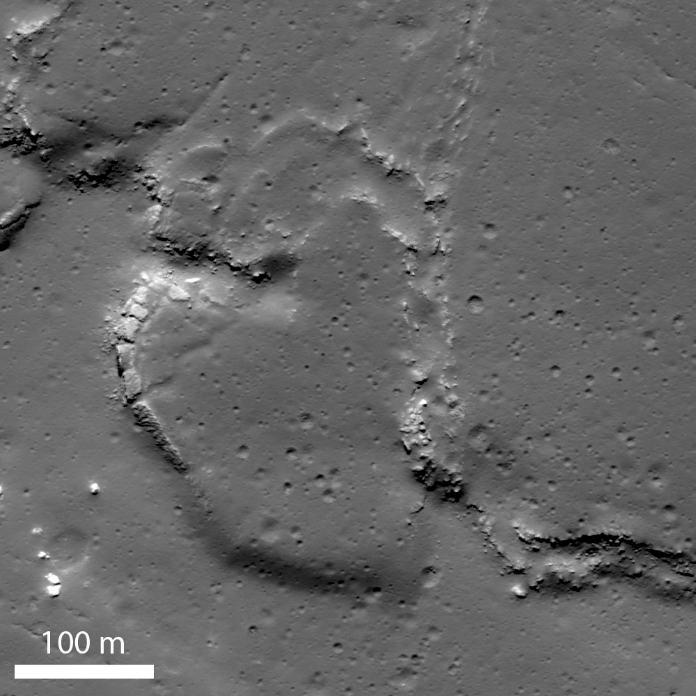
LROC NAC mosaic M1164853645RL, LRO orbit 23561, September 8, 2014; spacecraft and cameras slewed 3° from nadir, 33.17° angle of incidence, 71 cm resolution from 68.29 km over 33.07°S, 355.72°E [NASA/GSFC/Arizona State University].
Hell Q (3.75 km; 33°S, 355.53°E) seems younger than Tycho, standing out as it does in the nearside Southern Highlands northeast of the more famous astrobleme. 

There seems little doubt the effect of the larger, far more widespread blast zone from Tycho changed the face of this contemporary but pre-existing smaller crater. The chevron effect left grooves untouched down stream and tore away a chunk of the northeast rim, morphologies apparently perpendicular to a straight line drawn southwest to the more spectacular, 109 million year-old Tycho.

View full resolution views, of a variety of sizes, HERE.

Wednesday, July 31, 2013

Melted Moon

Click for full resolution LROC mosaic
The fresh lunar crater Giordano Bruno -a wealth of fascinating landforms to study. (click image for full resolution view, or HERE for a wider, medium resolution field of view showing the entire crater) [NASA/GSFC/Arizona State University].
Paul D. Spudis
The Once and Future Moon
Smithsonian Air & Space


Prior to the Space Age, one of the longest running controversies in lunar science was over the origin of the Moon’s craters.  Two camps emerged, one favoring an internal (volcanic) origin and the other an external (impact by solid bodies) origin.  Although this debate was finally resolved in favor of impact, the argument was long and vehement, reigniting at one point during the flight of the last of the robotic precursor probes to the Moon, prior to the Apollo landings.  Although the basic physics of impact were well understood by the mid-1960s, this newest argument centered around high-resolution pictures obtained by Lunar Orbiter 5 (1967) of the fresh (and therefore young) crater Tycho.  These spectacular images showed a multitude of flows, smooth ponds, and fluid rock, seemingly draped over hills and hummocks (like a chocolate shell coating over a scoop of ice cream).

An asteroid possesses an enormous amount of kinetic energy when it strikes a planetary body at very high speeds.  On contact, the asteroid vaporizes and the surface target rocks are intensely compressed.   After the shock wave has passed, these rocks decompress and the release of this energy totally melts part of the crustal target.  This material is said to be shock melted, with the resulting liquid called impact melt.  Impact melt was first described from craters on the Earth, particularly some of the very large impact craters found on the ancient Canadian Shield.  These rocks superficially resemble some volcanic rocks, having both fine-grained textures and partly melted inclusions.  But unlike volcanic rocks, they have high concentrations of siderophile (“iron-loving”) elements, such as iridium.  These elements are extremely rare in the Earth’s crust, but are more abundant in meteorites and asteroids.  It is thought that they are added to the melt from the incoming projectile.

The newest chapter in the argument about the origin of craters came about because some landforms around Tycho look similar to small-scale volcanic features on Earth.  The idea proposed was that the craters had been formed by impact, with those collisions triggering volcanic activity and producing multiple episodes of eruption at Tycho and other craters.  At first glance, such a scenario seems plausible.  After all, impact is a catastrophic event and one can imagine churning seas of subsurface liquid rock, released suddenly through the creation of fractures deep in the crust.  But the Moon’s interior is relatively cool.  If interior melt exists, it is at a level much too deep for any reasonably sized impact to tap.  But these amazing landforms needed to be explained.  What might they represent?

We found abundant physical and chemical evidence for impact (including shock-melted rocks) by studying the Apollo samples.  They appear similar to volcanic lava, with inclusions, melt textures and even vesicles (holes), comparable to the ones produced by magmatic volatiles coming out of solution in basaltic lavas on Earth.  Although it took a bit of study (and many more arguments) to establish their origin, shock melting became recognized as an important lunar (and Earth) impact process.

M160029952LR-109-1160x1600
Breech in the northwest rim of Tycho connects to the spectacular melt ponds inside out outside of the 109 million year old landmark crater. Illustration originally from "Landing Site at Tycho North," March 20, 2013 [NASA/GSFC/Arizona State University].
The images of the flows and ponds seen around Tycho and other fresh lunar craters led to a better understanding of how these rocks formed.  Although we knew about impact melting from the study of Earth’s craters (and had found evidence of the same in lunar samples), some researchers still weren’t convinced that we were seeing flows of liquid impact melt on the Moon.  The leading non-volcanic alternative was that these features were flows of dry, fine-grained granular debris.  In part, this interpretation proceeded from the observation that the thermal signatures of some of these melt-like flows suggested the presence of fine debris rather than bare, jagged rock.  Yet other data, such as radar backscatter, suggested that rough surfaces were common, while extremely high-resolution images showed abundant blocky craters on the surfaces of the flows, suggesting they were composed of solidified rock.

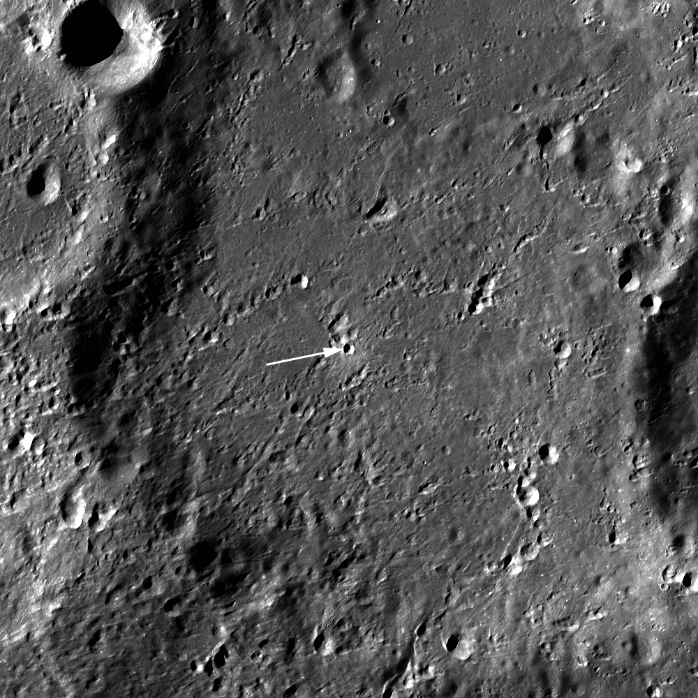
Landing site of Surveyor 7 (arrow) in relation to it's hoped for target, the kilometer-sized impact melt pond immediately to the northeast, part of the spectacular melt throughout the vicinity of Tycho [NASA/GSFC/Arizona State University].
Images from the robotic Surveyor 7 (1968) spacecraft, which landed on the rim of Tycho, revealed the thinnest regolith (soil) covering of any site on the Moon.  Visible in the surface panoramas were flow features covering the distant hills.  It took a great deal of painstaking, detailed work to establish that these flows and ponds were composed of liquid rock, created simultaneously with their host crater and likely originated by impact melting and subsequent solidification.

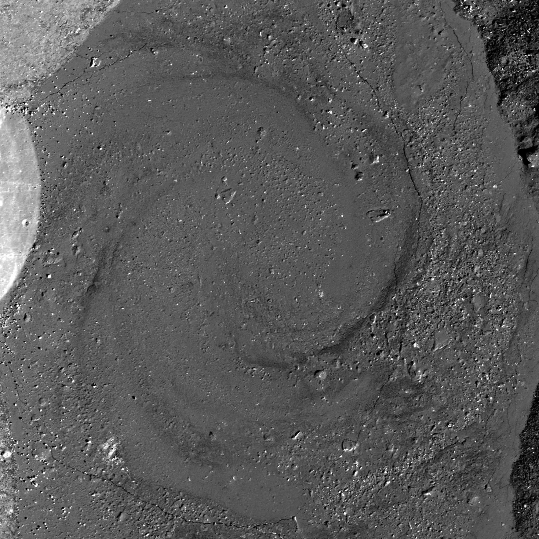
For the last several years, NASA’s Lunar Reconnaissance Orbiter (LRO) has been sending us new and astonishing views of the Moon’s impact melt flows.  Whereas fresh craters like Tycho, Aristarchus and Copernicus were well known from previous Lunar Orbiter frames, far side craters like the spectacular Giordano Bruno can now be seen with incredible clarity.  G. Bruno is one of the very youngest craters on the Moon.  A low density of craters overlying G. Bruno suggests an age of less than a couple million years (extremely young on a planet where most features count years in the billions).  It is an astonishing spectacle of melt shapes and deposits (cracked floors, pools, flow festoons and lobes); the crater floor has an amazing whirlpool of solidified melt. All these features indicate that after the crater formed, the impact melt was mobile, flowing and collecting, and ponding in low areas.

Impact melt forms a swirled feature in Giordano Bruno crater. Field of view 1 kilometer. From LROC Narrow Angle Camera (NAC) observation M143947267L LRO orbit 6347, November 9, 2010; 53.08° angle of incidence, 57 centimeters per pixel resolution from 54.50 km. Illustration from "Giordano Bruno Whorl," June 8, 2013 [NASA/GSFC/Arizona State University].
Impact melts are of great interest to geologists.  Unlike other crater ejecta, the radiometric clocks of impact melts are completely re-set by the melting.  Thus, if a sample can be obtained first-hand, directly from an observed flow or pool of melt around a host crater, the age of that rock specifically and unambiguously dates the impact event.  Unfortunately, we did not visit such deposits during the Apollo explorations.  What we do have are loose samples of lunar impact melt but not their scientifically important corresponding geological context.  It is for this reason that the age and sequence of early lunar history is so contentious – we must make educated guesses about where certain melt rocks come from.  If we get the context wrong, then our conclusions about the history of the Moon are incorrect.

Increased understanding of the generation and deposition of impact melt comes from the new images obtained by the LRO camera of the geologic setting of impact melts.  Future sample return missions to the Moon can be directed to landing sites that will provide us with samples of clear geological context (that they were from that area and not just flung there by an impact occurring elsewhere on the lunar surface).  As features age on the Moon, subsequent geologic events (such as superposition of new units) bury or erase the original event making the context less clear.  This problem is particularly acute for the oldest features on the Moon (multi-ring impact basins).  By studying the geology of the freshest lunar features (such as Tycho and other fresh craters), we understand how the older impact features looked immediately after their formation.  Thus, they serve as a guide to the interpretation of the older features.  On the Moon, as on the Earth, as Charles Lyell, the 19th century author of the classic Principles of Geology aptly put it:  The present is the key to the past.

Collection of spectacular impact melt features from LRO:
Giordano Bruno high-resolution full view
G. Bruno sunset
G. Bruno flows
G. Bruno cracked melts
Tycho oblique
Tycho floor
Tycho river of rock

Originally published July 31, 2013 at his Smithsonian Air & Space blog The Once and Future Moon, Dr. Spudis is a senior staff scientist at the Lunar and Planetary Institute. The opinions expressed are those of the author but are better informed than average

Wednesday, March 20, 2013

Landing Site at Tycho North (Science Concept 7)

A Ready-Made Landing Site?   One among many 'flash-frozen' impact melt ponds, a flow over the rugged ejecta immediately north of Tycho crater halted in place 109 million years ago. This one is 800 meters long along its north-south axis, and apparently level, nested about half the distance between the 1968 unmanned Surveyor 7 lander and a geologically interesting breach on Tycho's rim. LROC Narrow Angle Camera (NAC) observation M111668133RE, LRO orbit 1590, October 31, 2009; resolution 51 cm per pixel, angle of incidence 47.88° photographed from 49.39 km [NASA/GSFC/Arizona State University].
Second in a series of posts highlighting newly-proposed lunar landing sites selected to address high-priority science goals - from a remarkable landing site study published by the Center for Lunar Science and Exploration (CLSE):

Another image, less close-up, of the proposed 'Tycho North' landing zone, at slightly less granular resolution (0.65 meters per pixel), the nominally level melt pond is visible in greater context, nested in the rough and debris-strewn Tycho ejecta. The local slope runs from east to west but, overall, lower north and away from 86.2 km Tycho. From a mosaic, LROC NAC M106950070LR, spacecraft orbit 901, September 7, 2009; from 63.18 km altitude, angle of incidence 45.55° [NASA/GSFC/Arizona State University].
Joel Raupe
Lunar Pioneer

On February 5 we discussed a proposed landing site in Amundsen crater selected to support "Science Concept 4" as outlined in the commissioned National Research Council (NRC) study The Scientific Context for the Exploration of the Moon (2007).

In this second of a planned series we move to an area north of Tycho visited by Surveyor 7 in 1968. Material from the region was also very likely sampled by Apollo 17 in 1972, as Eugene Cernan and Harrison Schmidt explored Tortilla Flats in Taurus Littrow Valley, 2200 kilometers away.

While working with those same samples at the Johnson Space Center's Lunar Sample Laboratory Facility, Jack Schmidt soon helped estimate the age of samples collected at the base of South Massif directly opposite from Tycho at 109 million years. When the Tycho event happened, only 44 millions years remained before a similar impact ended the long reign of dinosaurs on nearby Earth. When offered as an example of the Moon's young craters the immense differences between terrestrial and lunar timescales and surface preservation rates are made stark. Such differences make it easy to forget that Earth and Moon have essentially shared the same location in the inner Solar System for 4.5 billion years (with Earth being a larger target and deeper gravity well). A study of the impact history and space weathering environment preserved on the Moon is a study of a much better preserved record of Earth's history.

This landing zone was proposed to address "Science Concept 7," a site that first presented to the Lunar and Planetary Science Conference in 2012 (Abstract #1387), from work produced by the Lunar & Planetary Institute Summer Intern Program the previous year. More detail emerged in the final CLSE landing site study of each of the NRC's 2007 lunar science goals, last fall. The LPSC 2012 abstract and contribution to the final CLSE study are credited to director David A. Kring and LPI 2011 interns Sarah Crites, Agata Przepiórka, Stephanie Quintana, Claudia Santiago and Tiziana Trabucchi.

"Science Concept 7" outlined in the National Research Council's NASA-commissioned Scientific Context for the Exploration of the Moon (2007). The Center for Lunar Science and Exploration (CLSE) released "A Global Lunar Landing Site Study to Provide the Scientific Context for the Exploration of the Moon" in late 2012, an exhaustive study of possible landing sites selected to address NRC 2007 lunar science concepts and goals [CLSE/LPI/NLSI].
The sites appearing in the new CLSE study might be broadly separated into two sets, ranked lists of many possible landing sites picked to fulfill all or overlapping part of the goals under the Science Concepts or individual targets picked in hopes of addressing all goals within one Science Concept and possibly overlapping with one or more of the other Concepts.

In other words, the ranks of possible landing sites in the new study range from those picked to accomplish much within practical, logistical and budget constraints over the next two decades to a long list of sites that may require 50 to 100 years to directly sample, along with a few lists falling somewhere in between. This might be a reflection of the political changes occurring over the years since the study began, when renewed exploration and establishing an extended human presence on the Moon went from being National Space Policy to falling by the wayside.

The new study is highly useful, regardless. Along with the Lunar Impact Crater Database, an even more detailed picture of the origins, ages and compositions of the Moon's complex features has been coming into focus, reflecting the astounding range of detailed information about the Moon collected in recent years.

Another full resolution LROC NAC view of the proposed landing zone, from a mosaic of the left and right frames of LROC NAC observation M111668133LR, LRO orbit 1590, October 31, 2009; incidence angle 47.82° from 49.39 km [NASA/GSFC/Arizona State University].
Since the goal is to establish definitive baselines, the actual ground truth of the upper few centimeters of the Moon's surface, why land near Tycho, the 86.2 km-wide astrobleme (41.49°S, 348.23°E) that is so much younger than its counterparts from earlier eras that have long faded into the albedo background? As it turns out, it's precisely because of such notably pristine.conditions, a comparatively youthful impact upon a region older than Mare Imbrium, that led Kring and his colleagues to seek this place out - along with proximity with Surveyor 7.

Understanding the dynamics of the upper few centimeters of the Moon's surface, most of which is turned-over, or "gardened" every couple of million years - involves more than dust mitigation or the charging and levitation of sub-micron dust as it interacts with radiation from the Sun and deep space or the Moon's nested crustal magnetic fields. Researcher will need a better understanding of this blasted layer of fine particles on wildly different timescales.

A really outstanding oblique view shows the proposed Tycho North Landing Zone from up over a spot 100 km west of Tycho, offerring even more perspective on the complex terrain surrounding the target melt pond (near center). Inset (see rectangle below) from an oblique (59° east of nadir) LROC NAC mosaic of from LROC NAC M1101317790, LRO orbit 14632, September 3, 2012 [NASA/GSFC/Arizona State University].
Thumbnail of the entire LROC NAC M1101317790RLR mosaic shows the area of the target melt terrace (the field of view in the immediately preceding full-resolution crop is framed by the yellow rectangle) in relation with Surveyor 7 and the rim of Tycho, 20 km south (to the right). Incredibly - at full resolution - the Surveyor 7 lander is actually visible in the full image. A proposed science station on the rim of Tycho is just outside this view at lower right [NASA/GSFC/Arizona State University].
Up, over and just beyond Tycho's 1200 meter high rim, the proposed LZ pictured above sits roughly at 620 meters elevation above the lunar geode (near 41.49°S, 348.233°E), the Moon's mean elevation, just out of sight from the sharp 800 meter drop down the crater wall (check this). The familiar crater's complex ejecta blanket extends 110 km from the central peaks, and its famous rays, visible to the naked eye, extend past 2000 km.

Beyond the debris piled high on the Tycho rim, the area of interest north by northwest of the crater, is characterized by slopes from 4.5 to 6° - safe for manned and unmanned landers. The specific Landing Zone is approximately 20 km from the rim fall off, where ancient pre-impact regolith appears to be exposed in layers visible in LROC NAC photography.

Because Tycho excavated pre-Imbrium nearside Southern Highlands, "any paleoregolith layers in Tycho's walls will also have a pre-Imbrium age," Kring and his colleagues note.

"Tycho's crater walls are the best target for sampling," though the upper reaches of the mountainous rim between the landing zone and the crater wall retain slopes greater than 25° "a navigable route to access layered deposits can probably be found."


Clementine multi-spectral mosaic color-coding overlaid on LROC Wide Angle Camera (WAC) 100 meter global mosaic shows the Science Concept 7 proposed landing site (arrow) is near the border between two widely different surface compositions [NASA/GSFC/DOD/ASU].
"The site provides access to regolith produced from substrates of different compositions (see image above)," from the coherent melt pond of the landing site itself to "rubbly ejecta... in a highlands area far from" the unique Procellarum, Potassium and Rare Earth (PKT, or 'Procellarum KREEP') terrain, covering so much of the nearside's west quarter.

Because the Tortilla Flats formation, sampled by Apollo 17, and nearby Surveyor 7 sampled materials related to the Tycho impact event "we can leverage these previous missions to compare properties of regolith of the same age formed from different types of ejecta."

Fifty km-wide LROC WAC field of view barely hints at the complexity of the terrain around the rim of Tycho. The suggested "Science Concept 7" landing site is an equidistant 10 km 'walk-back' distance (as the orbiter flies) from the 1968 landing site of Surveyor 7 (the last unmanned U.S. lander) and a suggested science station, a rare, dramatic breech in the sharp wall of the 'young' 109 million year old crater. The peninsula of melt piled into a comma below and to the right of Surveyor, was shown at very high resolution in "Giant Flow of Tycho Impact Melt," LROC Featured Image released August 14, 2012. LROC WAC (M168272917-9335CE) monochrome (643nm) mosaic   [NASA/GSFC/Arizona State University].
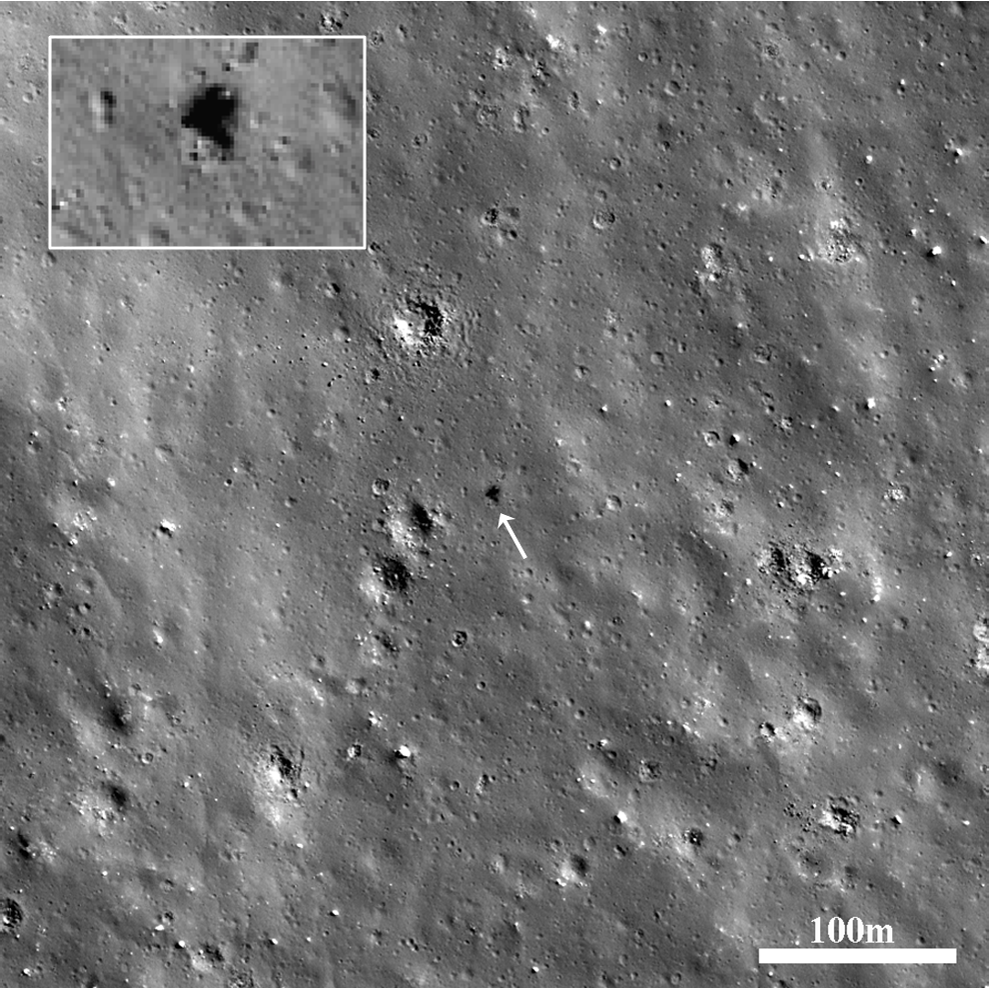
One of the best all-around LROC NAC images of Surveyor 7 (below left, arrow, and at full-resolution in the inset), from M150598504L, LRO orbit 7327, January 25, 2011; spacecraft and camera slew -15.17° from nadir, resolution 0.52 meters per pixel, angle of incidence 69° from 45 km. This roughly 300 meter wide field of view also includes another Tycho melt pond, the landing site Surveyor project manager Gene Shoemaker had hoped for as eventual landing site for this last vehicle of the program. The tripod lander's square sail, atop a supporting mast, casts a distinctive shadow [NASA/GSFC/Arizona State University].
Nearby Tycho's Rim - A possible breech in Tycho's high rim - within walking distance of the proposed Landing Zone, in the opposite direction from Surveyor 7 - may provide sampling access to the layered regolith visible above center-right. This angled corner on the north-northwest rim of Tycho was clearly modified very soon after the crater formed. Whether the slope below is too great to allow men and machines invaluable direct access to Tycho's equally interesting interior is still uncertain. LROC NAC mosaic M160029952LR   [NASA/GSFC/Arizona State University].
Some perspective to the proposed Science Concept 7 science station, on Tycho's rim (arrow) and the crater rim, wall and floor. Melt ponds dot the region. (In this oblique view, the landing zone and Surveyor 7 locations are outside this frame.) Still from video prepared from JAXA photography and data collected by the SELENE-1 (Kaguya) [JAXA/SELENE].
Establishing the rate and manner space weathering leads to the optical maturing (OMAT) of the Moon's surface will help researchers understand processes ranging from the interaction of reactive dust with crustal magnetism - the age and deposition rates of the Moon's swirl phenomena - the deposition of lunar volatiles and tighter estimates of the age of craters between one and two billion years old, past the time needed for optical maturity to do its work. 

Tycho, a recent rich excavation of the Moon's nearside Southern Highlands, and sights along a potentially valuable ingress to the crater's interior demonstrating the potential value of a single rather multiple expeditions. LROC WAC mosaic stitched from four sequential orbital overflights  LROC WAC (M168272917-9335CE) monochrome (643nm) mosaic   [NASA/GSFC/Arizona State University].
Remote sensing maturity maps hint the proposed landing site is characterized "by both very immature and intermediately mature soils," according to Kring and colleagues, "providing an opportunity to see the evolution of space weathering processes."
 
Proximity with Surveyor 7, about 20 km away, in the opposite direction from Tycho's rim, allows study of a known surface, and for a known amount of time (since 0600 UT, 7 January 1968), a stated goal in the NRC's 2007 commissioned report.
 
It's hoped the 20 km distance from the proposed landing site will prevent Surveyor 7, as a valuable 'long-duration exposure facility," from being undermined like Surveyor 3, ultimately swept clean by the descent of Apollo 12 only 183 meters away in 1969.Surveyor 7 may provide a "more pristine" baseline for measuring short-term space weathering.
 
The Tycho North landing site clear of any known crustal magnetism, free of space weathering processes both accelerated and slowed, as they appear to have been at Reiner Gamma, for example. Samples should therefore be "better representative of the lunar highlands."
 
The rate of solar-wind production of volatiles "can also be nicely calibrated here," Kring and his colleagues have noted, since "the exposure age is known and the orbital relationship between the Moon and the Sun is unlikely to have changed significantly over that period."
 
Chemical traces of the object that created Tycho Crater may be be found in the melt-rich rocks at the landing site, along with the shattered pieces of more distant and much older events in the 'recently' exposed paleoregolith uplifted in layers at Tycho's rim.

Some Related Posts:
Amundsen crater and the CLSE Landing Site Study (February 5, 2013)
Rippled Pond on Tycho's Wall (September 13, 2012)
Breached Levee at Tycho (September 11, 2012)
Giant Flow of Impact Melt (August 14, 2012)
River of Rock (June 20, 2012)
View from the Other Side (May 21, 2012)
Impact Melt Fingers (May 8, 2012)
Melt on a Rim (May 3, 2012)
Tycho Central Peak Spectacular (July 5, 2011)
Chaotic crater floor in Tycho (June 19, 2011)
Polygonal fractures on Tycho ejecta deposits (June 15, 2011)
Ejecta on slumped wall of Tycho (December 9, 2010)

When the Moon is full, Tycho's bright ray system is among the few lunar features visible to the naked eye. A testimony to its youth, a low degree of steady space weathering when compared to hundreds of similar but older crater,s from before the time when dinosaurs ruled the earth. The "miracle boys of Minsk" (Astronominsk) captured this local late morning image of Tycho, part of a full disk monochrome mosaic, captured from Belarus, September 20, 2010.  One of their fabulous color images of Тихо can be viewed HERE [Astronominsk].

Thursday, September 13, 2012

Rippled Pond on Tycho's Wall

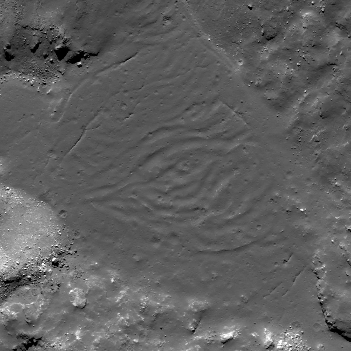
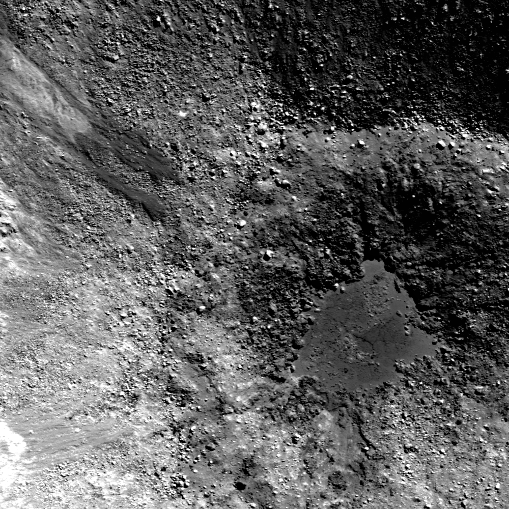
A melt pool on Tycho's northeastern wall has a rippled, somewhat wrinkly texture. Why might the surface look this way? 792 meter-wide field of view from LROC Narrow Angle Camera (NAC) frame M185947368R, spacecraft orbit 12481, March 9, 2012; angle of incidence 45.21° at 66 cm resolution from 63 kilometers. View the full-sized LROC Featured Image, HERE [NASA/GSFC/Arizona State University].
Lillian Ostrach
LROC News System

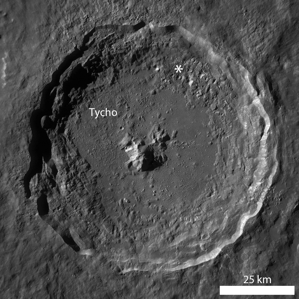
By now, it should be obvious that Tycho crater has many spectacular geologic features. Numerous Featured Images have explored the crater, its ejecta, and impact melt deposits. Today's Featured Image focuses on a melt pond located in the northeastern crater wall terraces (42.469°S, 349.672°E).

The pond is relatively isolated, having formed in a depression where the melt pooled after streaming down the crater wall, and does not appear to connect to other, smaller melt ponds along the break in wall-slope. Above and below the pond is the thickly veneered crater wall, but the wall below the pool is rougher and the melt veneer is more fragmented and exhibits some mass-wasting erosion.

An in-depth look at the melt pond reveals linear cracks that have been partially filled in with thin regolith. These cracks may represent cooling cracks that formed as the pond cooled and decreased volume, where some melt at the pond edge remained "stuck" as the remainder of the pond cooled and contracted. Alternatively, the fractures may have formed in the thinnest portion of impact melt, possibly representing changes in the underlying topography, which is probably variable and uneven in the chaotic wall terrace material. However, take a look at the center of the pond - what do you see?

LROC Wide Angle Camera (WAC) monochrome mosaic of Tycho, showing the location of the area at high resolution in the LROC Featured Image released September 13, 2012 noted with an asterisk [NASA/GSFC/Arizona State University].
The center of the melt pond is deformed in a vaguely wrinkly, broad wave-like rippled region. The ripples are contained in the pond center in an approximate circular shape except for an elongation toward the left of the image. What could this morphologic feature possibly be? The ripple morphology is similar to the texture you might observe when removing the surface skin off a glass of hot milk with a spoon. The surface skin (or crust) on the milk deforms due to the force of the spoon as you gently attempt to collect the milk-skin before adding your hot cocoa mix and marshmallows. Consider a geologic example: as pahoehoe lava flows down the pali (steep slope) in Hawaii, the surface of the flow begins to cool and a crust forms. As the lava continues to flow downhill, the cooling lava slows down but the hotter lava uphill continues to flow fast, so the cooling lava begins to deform and wrinkle.

Might this process be applied to the Moon? Sure! Tightly wrinkled, deformed impact melt is visible in the exterior flows at Tycho where there is a prominent change in surface slope. However, the melt pond in the Featured Image is not precisely like these exterior flows, but perhaps there is enough slope change beneath the pond to have affected the cooling melt and thus form these undulating ripples. Right now, we simply do not know, but a detailed scientific study focused on the occurrence, morphology, and topography of these types of features may provide a better understanding of the geologic story of these features.

How many melt ponds can you find in Tycho's terraced walls in the full LROC NAC image, HERE? Do any of these ponds have a ripply, somewhat wrinkled texture?

Related Posts:
Tycho's flash-frozen inferno
River of Rock
Tycho Central Peak Spectacular!
View From the Other Side
Breached Levee

The "miracle boys of Minsk" captured this forenoon image of Tycho, part of a full disk monochrome mosaic, from Belarus September 20, 2010. This is the familiar view of the 109 million year "young" crater. One of their fabulous color images of Тихо can be viewed HERE [Astronominsk].

Tuesday, September 11, 2012

Breached Levee at Tycho

Impact melt breached a levee to flow downhill on the terraced walls of Tycho. Downslope is toward image bottom, re-sampled from the roughly 500 meter-wide field of view seen in the LROC Featured Image released September 11, 2012, itself derived from LROC Narrow Angle Camera (NAC) observation M170634588L, spacecraft orbit 10280, September 14, 2011; angle of incidence 41.67° at 50 cm per pixel resolution, imaged from 45.9 kilometers [NASA/GSFC/Arizona State University].
Lillian Ostrach
LROC News System

The geology within and surrounding Tycho crater is nothing short of spectacular. LROC images have shown the beauty of Tycho's 2 km-tall central peak, the morphology of impact melt on the crater floor, and the complexity of the exterior impact melt flows. Today's Featured Image once again highlights a geologically fascinating impact melt flow located on a terrace of Tycho's northern wall (42.428°S, 349.190°E).

When substantial amounts of impact melt are generated during the impact process, evidence of ejected melt is observed in the form of exterior melt ponds and flows, as well as veneers and channels within the crater walls. Whether interior melt coalesces to form channels or flows on the crater walls depends on numerous factors, including the viscosity of the melt and the volume of melt distributed on the walls. As melt cools, it becomes more viscous and less prone to flow, and thin veneers of melt splashed on crater walls will cool very quickly compared to thick melt ponds. However, if lots of melt is splashed onto the crater walls, the melt may coalesce and take longer to cool, perhaps allowing flows to form with the increased volume of melt. Channels, however, are believed to require melts of higher temperature (low viscosity) in order to form levees and mechanically and/or thermally erode the terrain in which the channels form. Knowing this information, can you explain the impact melt morphology in the opening image?

LROC WAC (GLD100) monochrome mosaic draped over LOLA altimetry elevation data (128ppd, v.2) in LMMP ILIADS simulated perspective over Tycho crater (85 km diameter). Arrow notes location of field of view shown at high-resolution in LROC Featured Image released September 11, 2012. View original LROC WAC context image HERE [NASA/GSFC/Arizona State University].
The opening image is an area on the northern terraced wall of Tycho that is covered in impact melt. Since Tycho wasn't formed yesterday, a thin regolith layer covers the melt (created by small impacts and micrometeorite impact gardening) and there are boulders eroding out of the slope. Cracks, softened by the thin regolith, abound in this region, and probably represent cooling cracks. There is a levee-like feature winding from the upper left to the lower right that probably was formed by impact melt that coalesced and flowed down the interior walls, essentially representing the flow boundary. However, a tongue-like flow obscures a portion of the levee-like boundary. Assuming that a large volume of melt was channelized where the inside of the channel was toward the right side of the opening image, this late-stage small flow (or drip) bypassed the leveed wall on its descent toward the crater floor. Where did the material composing the small flow come from? Perhaps some melt from the surrounding walls flowed toward the levee-like boundary but got "stuck" and pooled on the top portion of the levee, until the weight of material overcame the levee barrier. Or maybe the tongue-like flow represents a late-stage splash of melt that was ejected and then landed on the wall to drip down toward the crater floor.

What do you think? Scour the full LROC NAC image, HERE, and see what other impact melt morphologies you can find!

Related Posts:

Friday, September 7, 2012

LROC: America's last unmanned lunar lander

Surveyor 7, on the ejecta blanket of Tycho, the last of the Surveyor spacecraft (1967-1968), and the only one of the series to land in the lunar highlands. LROC Narrow Angle Camera NAC frame M175355093L, LRO orbit 10976, November 8, 2011; field of view is 500 meters across, viewed at the original scaled 43 cm per pixel resolution at an illumination incidence angle of 56.22° Inset, from the LROC Featured Image released September 7, 2012, is enlarged 4x [NASA/GSFC/Arizona State University].
Ryan Clegg
LROC News System

Surveyor 7 landed in the lunar highlands (40.980°S, 348.486°E) on 10 January 1968, on an impact-melt coated ejecta blanket 46.6 km (29 miles) north of the rim of Tycho Crater. The last spacecraft of the Surveyor series, it was sent to an area far from the mare in the southern highlands, in order to sample and analyze materials different from those of the other Surveyor missions. Surveyor 7 was the only Surveyor spacecraft to be sent to a region solely for scientific interest, rather than to obtain more data for the upcoming Apollo program, since program managers had decided that the previous Surveyor missions had already provided sufficient data to enable a safe Apollo landing. Results from the spacecraft’s alpha scattering detector showed that the highland crust is poorer in iron than the maria analyzed by the other Surveyors.

Landing site of Surveyor 7 captured at a higher angle of incidence (83.96°) and altitude (44.94 km),  in context with the prominent impact melt pond to the northeast, its intended landing site. LROC NAC observation M131724362L, spacecraft orbit 4545, June 21, 2010; resolution 50 cm [NASA/GSFC/Arizona State University].
Panorama of the Surveyor 7 landing site, taken by Surveyor 7 [NSSDC].

A total of 21,091 pictures were transmitted to Earth by Surveyor 7. One of the most stunning image sets is a photomosaic panorama of the landing site, which shows the rim of the 82-km diameter Tycho Crater on the horizon. On the surface of the Moon, as on Earth and elsewhere, impact craters are typically hidden from sight until you are standing right up on the rim. The Apollo 14 astronauts encountered this problem as well, when taking samples during a radial traverse of Cone crater. They lost sight of the crater rim during their traverse and eventually had to turn back before catching a glimpse of the interior of the crater in order to save enough oxygen for the journey back to the Lunar Module. LROC images (February 4, 2011, August 19, 2009) later confirmed that the crew came within 30 yards of the crater rim.

Surveyor 7 could only just make out the rim of Tycho Crater from its landing site. However, from an orbit of 50 km above the surface the panoramic view of the stunningly well preserved impact crater and its majestic central peaks is spectacular.

Simulated view from several kilometers above a point north of the Surveyor 7 (blue square) shows it's proximity with Tycho [NASA/LMMP/GSFC/Arizona State University].
The Surveyor missions not only provided critical engineering data that helped enable the safe Apollo landings that followed, but also showed that powered descent to the lunar surface was feasible and straightforward. Robotic precursor missions (such as automated sample return missions and in-situ resource utilization demonstrations) will undoubtedly play a similarly important role as we prepare for the seventh human lunar landing and beyond.

Be sure to explore the entire NAC frame (M175355093L) HERE. covering the Surveyor 7 site, and check out the central peaks of Tycho in the June 29, 2011 and May 21, 2012 Featured Images.

WAC context image of Tycho and the Surveyor 7 landing site [NASA/GSFC/Arizona State University].

Previous Posts Related to Surveyor 7:
LROC: Giant flow of Tycho impact melt (August 14, 2012)
Polygonal fractures on Tycho ejecta (June 15, 2011)
Surveyor 7 (February 12, 2011)
Surveyor 7: Our fragile lunar LDEF (October 27, 2010)
LOLA's Tycho and the Apollo era (March 28, 2010)

Related LROC Posts:
New View of Apollo 14
Trail of Discovery at Fra Mauro
Tycho Central Peak Spectacular!
View From The Other Side
Surveyor 1
Surveyor 3 and Apollo 12
Surveyor 5
Surveyor 6

Thursday, August 23, 2012

Twin pools in small Southern Highlands crater

Two small melt flows solidified on the wall of a young crater, and melt pooled in its center. situated on the broad floor of the crater Orontius, in the bright southern highlands immediately east of Tycho. LROC Narrow Angle Camera (NAC) M188270580RE, LRO orbit 12806, April 5, 2012. Image field of view is 700 meters. See the larger original LROC Featured Image HERE [NASA/GSFC/Arizona State University].
Drew Enns
LROC News System

Impact melt commonly forms during impact events on the Moon due to the tremendous energy released during such events.

Melt often forms ponds on crater floors or in nearby exterior depressions, and forms flows as it travels downslope. Today's Featured Image of a young crater in the lunar highlands, at 40.875°S, 355.277°E, appears to have beautifully preserved examples of both forms!

Can we be sure the flows pointed out here are actually frozen impact melt and not debris flows?

LROC Wide Angle Camera (WAC) global mosaic overlaying LOLA topography shows the small bright crater, surrounded by a very bright landscape in the vicinity of Tycho, inside the west wall of Orontius at lower center. View the original LROC WAC context image accompanying the LROC Featured Image released August 21, 2012 HERE [NASA/LMMP/GSFC/Arizona State University].
One clue is that the flows are not very blocky when most of the crater wall is. Instead the flows appear to have entrained rocks when traveling over blocky sections of the crater. But debris flows can also pick up boulders along the way! Unlike the melt pond the flows do not have a cracked surface, perhaps indicating that formed as flows of granular material? On the other hand the flows have lower reflectance, typically of glasses that form on the surface of impact melt. It is difficult to say which hypothesis is correct without more information!

Can you find more evidence to argue for impact melt or debris flow in the full LROC NAC frame HERE?

Related Posts:
Dichotomy
River of Rock
Crater in 3D!

Tuesday, August 14, 2012

LROC: Giant flow of Tycho impact melt

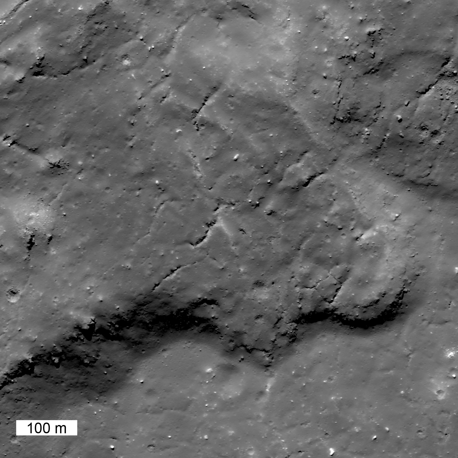
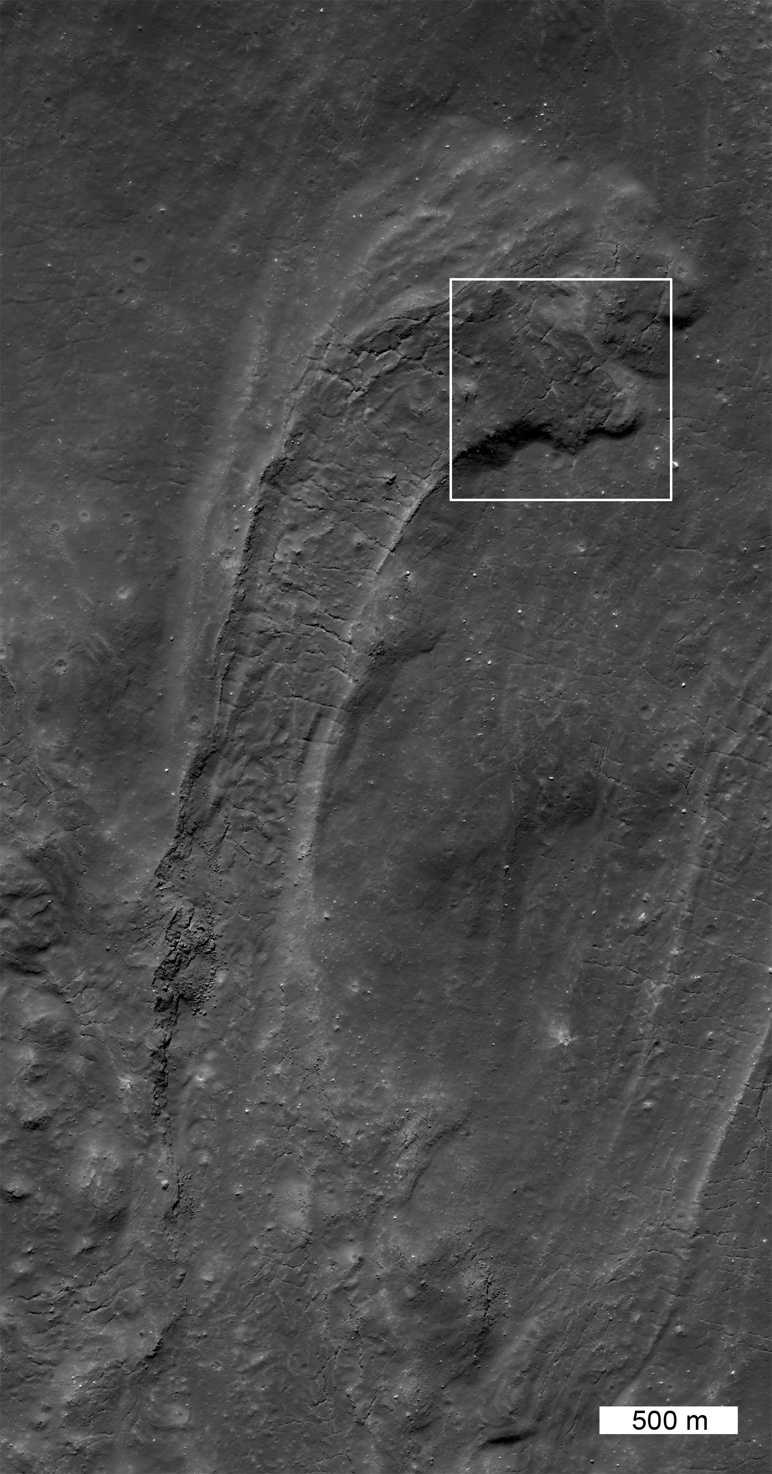
This giant fossilized glacier of impact melt extends north from a much larger mass of impact melt of the north rim of Tycho. This single section of the flow is more than 10 kilometers long. LROC Narrow Angle Camera (NAC) observation M185954551R, LRO orbit 12482, March 9, 2012; resolution is 0.6 meter per pixel of a 43.53° angle of incidence, from 64.8 kilometers altitude. View the larger LROC Featured Image HERE  [NASA/GSFC/Arizona State University].
Jeffrey Plescia
LROC News System

Impact melt is formed during the crater excavation process due to the intense heating of the target rocks. Some of the melt is ejected from the crater and deposited on the rim. In this case, on the north rim of Tycho, not far from the Surveyor 7 landing site, a large amount of melt was deposited, pooled and then flowed downslope away from the crater. This flow (41.162°S, 348.605°E) is about 21 km from the northern rim. Upslope, toward the rim, there are also numerous smaller pools of impact melt (now frozen to solid rock). Contrast this flow with the River of Rock on the southeast side of Tycho crater.

From a half-sized reduction of the original LROC context image (HERE), this expanded view of the full LROC frame (NAC M185954551R) shows more of the flow anatomy, extending north from Tycho. The white box shows the field of view included in the featured image above [NASA/GSFC/Arizona State University].
This giant frozen flow is more than 10 km long! When the flow emerged onto the plains it was about 1.3 km wide; at the terminus it spread out about twice as wide (2.7 km). Along the center of the flow is a channel with levees; the channel is about 1 km wide. In the levee walls and on the flanks of the flow are layers which formed when surges of melt spilled over onto the side of the flow. The morphology of the end of the flow, with lobes stepping to the right, indicates that with each surge, the end of the flow was directed eastward. The surface within the channel shows tension cracks that are perpendicular to the flow direction and formed as the solidified crust fractured. There are several other flows of impact melt on the northern flank, although this is the most dramatic. Impact melt also fills much of the crater floor.

Northern flank of Tycho, its wall, rim painted with flows and pools of ejecta; the arrows points to the flow highlighted above, the blue cross marks the landing site of America's last unmanned lunar lander Surveyor VII, highlighted below. LROC Wide Angle Camera (WAC) 604nm observation M152952485C, spacecraft orbit 7644, February 21, 2011; angle of incidence 57.41° at 63.7 meters resolution from 46.5 kilometers overhead [NASA/GSFC/Arizona State University].
Explore this giant impact melt flow in the full NAC image, HERE.

Ejecta on Tycho floor

The very successful and daring Surveyor 7 was successfully landed right in the middle of the complex Tycho impact melt fields, north of the crater, about 10 km away from the field of view included in the LROC Featured Image. Less than a kilometer, beyond view of the spacecraft's cameras, is s substantial melt pool, where Surveyor might easily have landed instead. LROC NAC M152952815R, LRO orbit 7674, February 21, 2011, resampled from the original resolution of 0.5 meters from 44.7 kilometers [NASA/GSFC/Arizona State University].

Wednesday, June 20, 2012

LROC: "River of Rock"

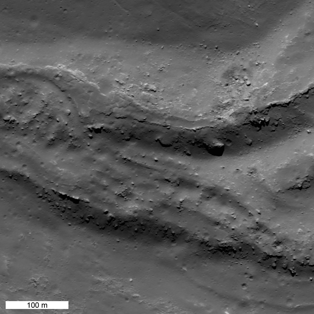
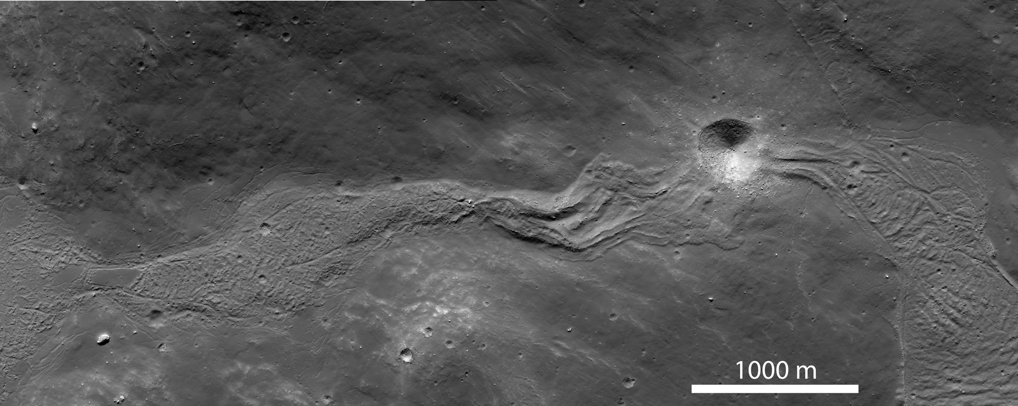
A small section of an enormous, now frozen, river of impact melt that flowed down the southeastern flank of Tycho crater some 108 million years ago. LROC Narrow Angle Camera (NAC) observation M185940195RE, LRO orbit 12480, March 9, 2012; angle of incidence 46.55° at 0.64 meters resolution from 61.72 kilometers. View the full-size 1000 x 1000px LROC Featured Image HERE [NASA/GSFC/Arizona State University].
Jeffrey Plescia
LROC News System

Impact melt is one of most spectacular products of impact cratering events. A comet or asteroid impacts the Moon at 10-60 km/sec, and releases so much energy that it melts a significant amount of the target rock. The larger the projectile, the bigger the crater, and the more melt that is produced. While much of the Tycho impact melt pooled on crater floor, some of it was thrown out of the crater onto the rim. A large mass of impact melt landed on the southeastern rim and flowed down the rim filling low areas and then spilling over and continuing downhill. Between pools, the melt formed narrow flows whose width was controlled by the topography.

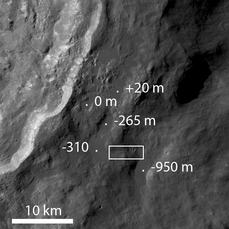
The context image (sub-sampled NAC mosaic) below shows a wider view of the impact melt deposit extending down slope from a high pool (on the left side of the image) at an elevation of about -310 m to a lower pool on the (on the right side of the image) that lies more than 600 m downslope (elevation -950 m). The flow is about 5000 m long; its width ranges from 300 to 700 m and is controlled by the topography of the surrounding hills. The texture of the flow surface and the formation of channels on its eastern end (above and below the crater) is a function of the slope of the underlying surface, and the changes in viscosity of the melt as it cools.

This contextual montage of the corresponding left and right frames of LROC NAC observation M185940195 allows this view of spectacular river of impact melt, now frozen, that briefly flowed down the southeastern flank of Tycho crater. View the spectacular full-size (2000 x 800px) context view HERE [NASA/GSFC/Arizona State University].
Contextual LROC Wide Angle Camera (WAC) image of the various pools and their elevations. Over distances of 10-20 km, the melt flowed down almost a kilometer in elevation. The white box roughly outlines the field of view shown in detail immediately above. LROC WAC observation M177698611C (604nm), orbit 11323, December 5, 2011, illumination from the northeast (upper right) at an 80.34° angle of incidence; 59.83 meters resolution, from 43.7 kilometers. View the original annotated context image HERE [NASA/GSFC/Arizona State University].
The last pool (-950 m elevation) to be filled by this melt flow has well preserved sharp morphologic features that tell scientists much about the history of emplacement. The overall pool is about 4500 meters long by 2100 meters wide.

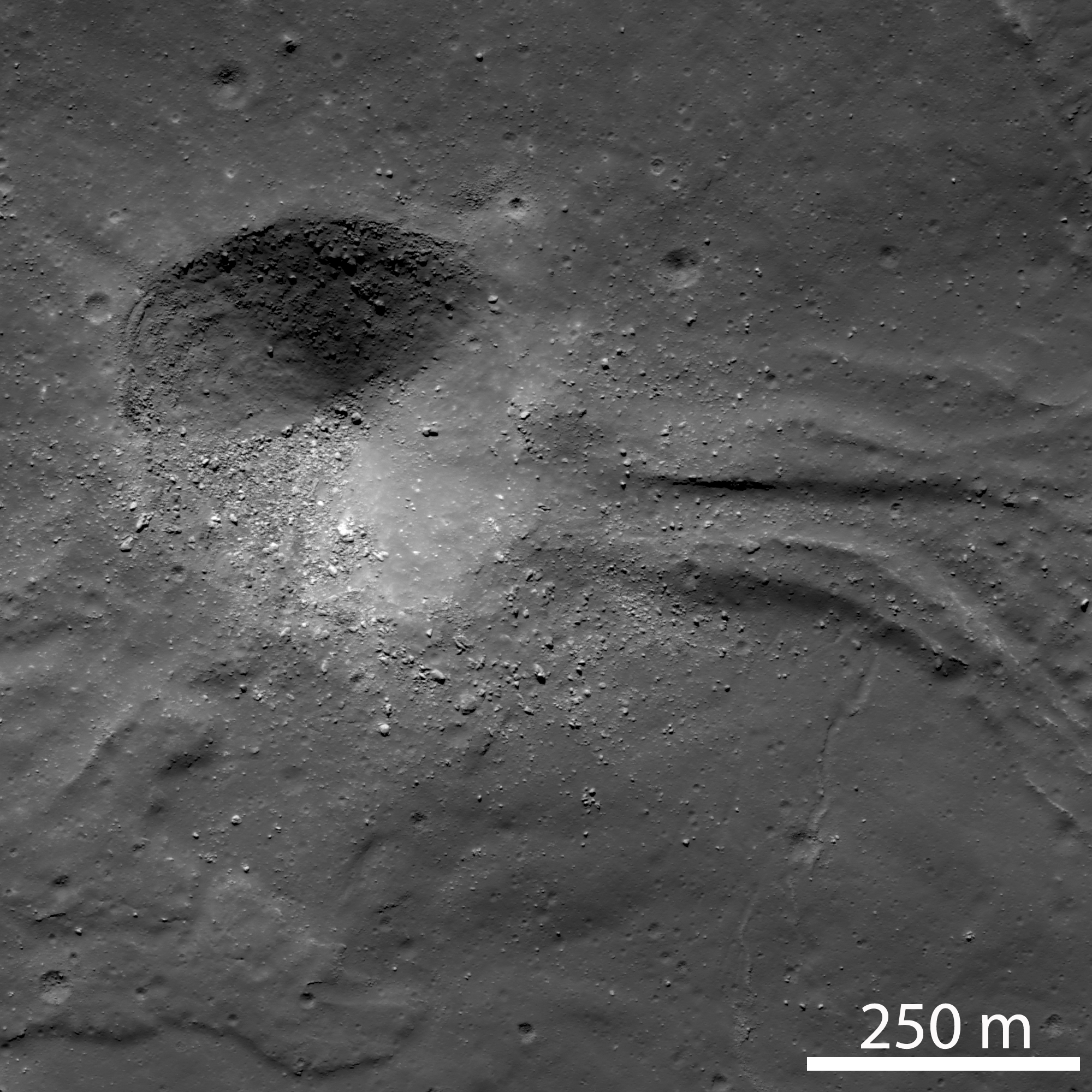
Context image of the lowest pool of impact melt, showing the locations of higher resolution images below. Cropped with depth distortion from the full size context image accompanying the LROC Featured Image, released June 20, 2012.  From a montage of the corresponding left and right frames from LROC NAC observation M181222542LR, orbit 11820, January 14, 2012; resolution 1.3 meters from 62.98 kilometers, angle of incidence 72.72° [NASA/GSFC/Arizona State University].
The impact melt flowed (A) eastward down a narrow valley from a higher pool to the west, then draining into and filling a depression at a lower elevation. To the east of the crater, the flow is about 250 m wide and exhibits a well-defined channel with levees about 60 m wide. Farther east the flow broadens into a large pool. Later a 400 m impact crater formed in hardened impact melt ejecting boulders up to 20 meters in diameter. This crater provides a great section through the flow for future geologists roaming about this geologic wonderland!

(A) A 400 meter impact crater obliterated the flow. View the original 2000 x 2000px detail, HERE [NASA/GSFC/Arizona State University].
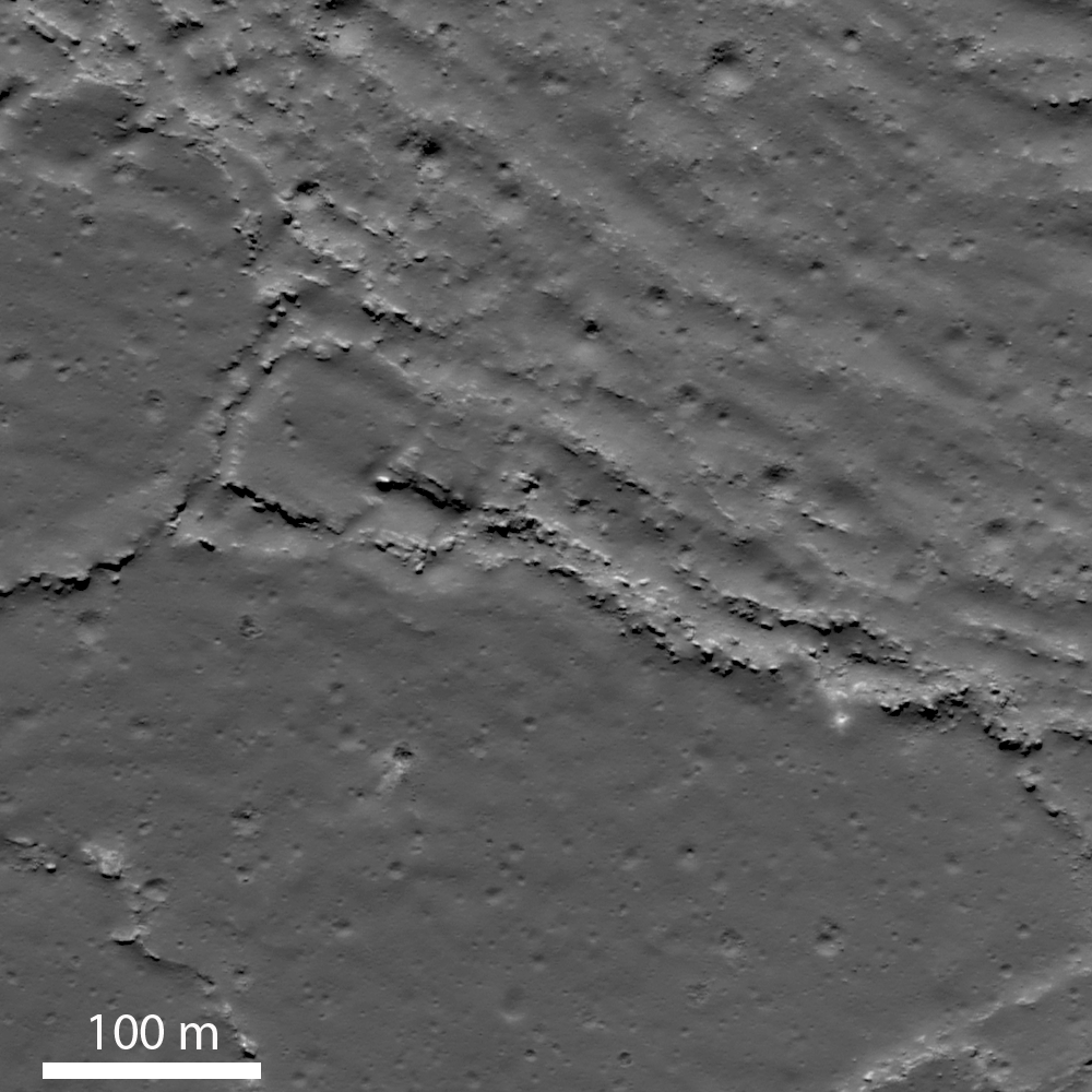
The upper right portion of image (B) shows a wrinkled flow surface with ridges spaced about 30-40 m apart; the lower left portion of the flow has a smooth surface. The two different surfaces suggest that there were different pulses of impact melt entering the pool. An initial pulse formed a relatively smooth surface, then a second pulse of melt entered the pool wrinkling part of the crust. As a crust formed on the cooling melt, continued movement compressed and deformed the surface into the wrinkled texture. Along the ridge crests, the crust has been broken up into slabs.
(B) Wrinkled and platy lava flow surface. View the 1000 x 1000px detail image, HERE [NASA/GSFC/Arizona State University].
The margin of one impact melt pools reveals a fascinating story (right hand side of image [C]). A series of northeast-trending disturbed zones, 25-50 m wide, cut the flow. The zones are likely are shear planes along which differential movement of the flow has occurred. These planes form boundaries between portions of the flow that moved laterally (to the lower left) by different amounts; the shearing movement has broken up the surface crust of the flow into a numerous small blocks. The edge of the flow is marked by a rubble zone.

(C) Shearing along the western margin of the pool. View the 1000 x 1000px detail image, HERE [NASA/GSFC/Arizona State University].
The southern end (D) is defined by a series of small lobes which probably represent breakout of still molten impact melt from the edge of the pool. The edges of the lobes are marked by plates of broken crust which presumably were rafted away from the original edge. The large lobe would have broken out from the end of the pool and flowed and broadened into a lobe about 200 m long and 300 m wide.

(D) Lobate terminus of impact melt pool. View the 1000 x 1000px detail image, HERE [NASA/GSFC/Arizona State University].
Explore the full resolution NAC frame, HERE.

Directly Related:
"Tycho's flash-frozen inferno," November 2, 2011

Related LROC Posts:
View From The Other Side
Tycho Central Peak Spectacular
Chaotic Crater Floor in Tycho
Polygonal Fractures On Tycho Ejecta

Simulated oblique view of the southeastern flank of Tycho, from "Tycho's flash-frozen inferno," a discussion of the stream of impact melt and its cascade down the rim of the 109 million year old relatively recent impact, posted here last November. Jeff Plescia of Arizona State University's Lunar Reconnaissance Orbiter Camera (LROC) science team covers the topic in more recent images and greater detail below [NASA/GSFC/USGS/Arizona State University/Google Earth]