 |
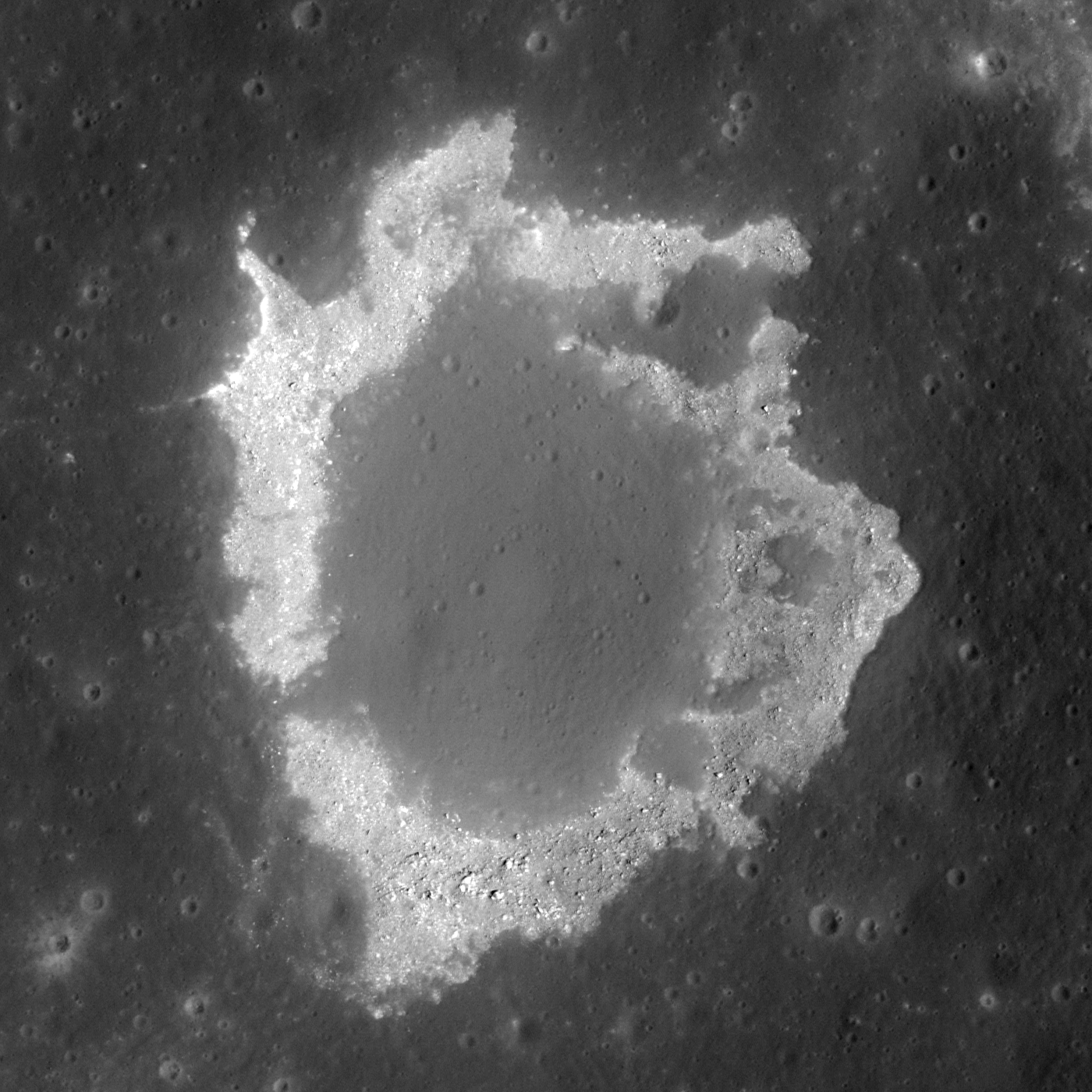
| Layers of terrain, the foundation under the heavily gardened upper surface of Lacus Mortis, "the Lake of Death," hints this feature, averaging 228 meters across, was, or is, a "pit crater," closely related to similar structures (discovered in the 21st century) near the Marius Hills, in Mare Tranquillitatis, Mare Ingenii and elsewhere. Though the east wall collapsed there may yet be an opening below a ledge. LROC Narrow Angle Camera (NAC) observation M126759036L, orbit 3814, April 24, 2010; 49.4° angle of incidence, resolution 0.5 meters from 45.56 km [NASA/GSFC/Arizona State University]. |

Lunar Pioneer
It was something of a sensation just a few years ago when Kaguya (SELENE-1) images unveiled a "pit crater," an honest to goodness opening into a sublunarean world.
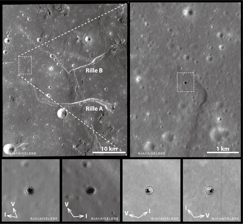
Ant this new feature was found right in the middle of the long-observed and studied channel of the unofficially named "Sinuous Rille A," in the Marius Hills of Oceanus Procellarum. What a difference, many thought, high resolution photography would make of our knowledge of the lunar surface.
And they were not disappointed. Most of what we now know of the lunar surface is entirely a product of the 21st century, largely a pay off from "precursor" missions vital to the success of a now-scrubbed program ahead of a return to the surface of "extended human activity" later this decade.
Junichi Haruyama and his colleagues reported their findings in Geophysical Research Letters in 2009, having captured the Marius Hills Pit at resolutions as high as 6 meters per pixel using the Kaguya Terrain Camera and Multiband Imager, as discussed by LROC principle investigator Marc Robinson, March 1, 2010.
 |
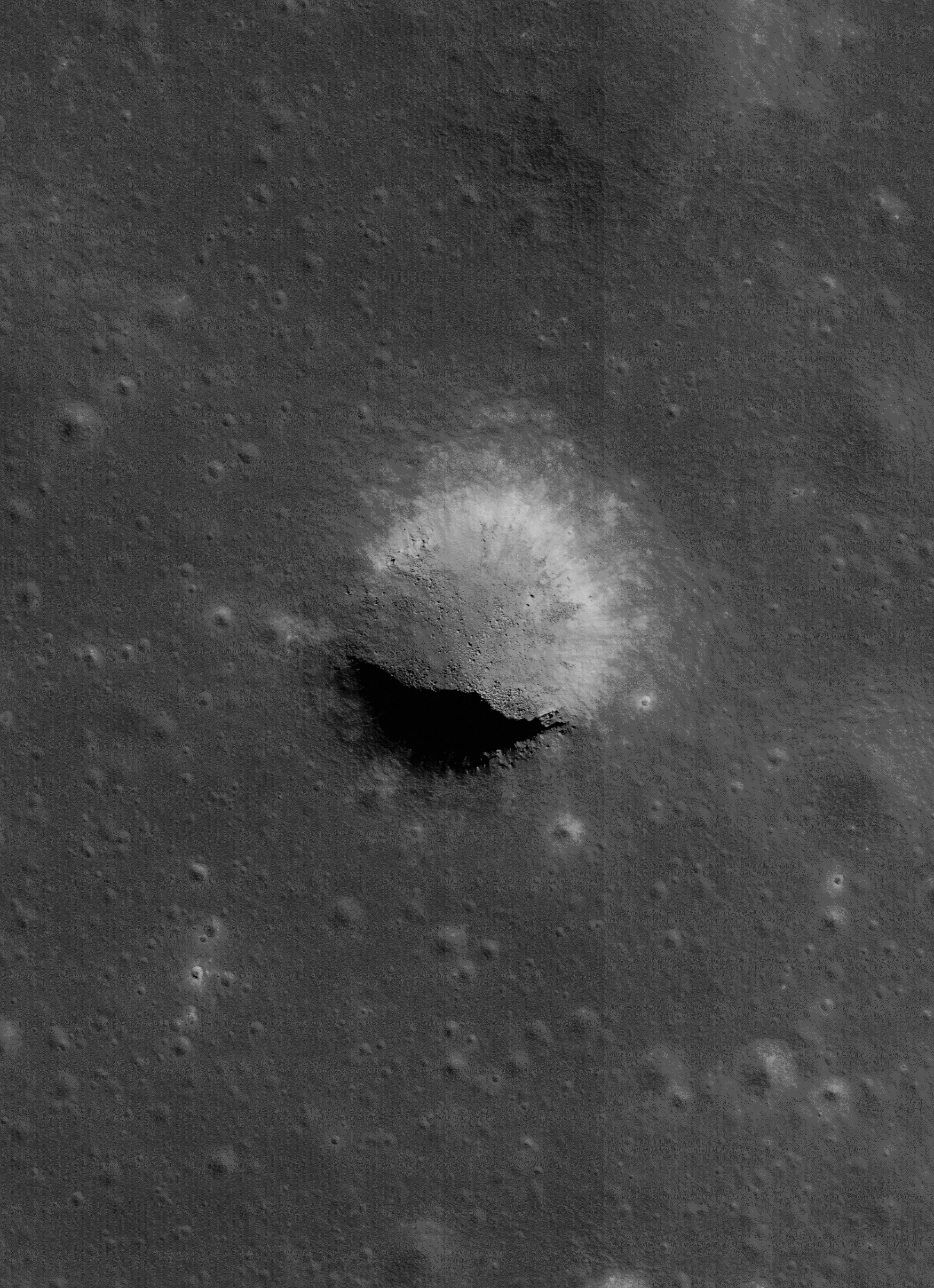
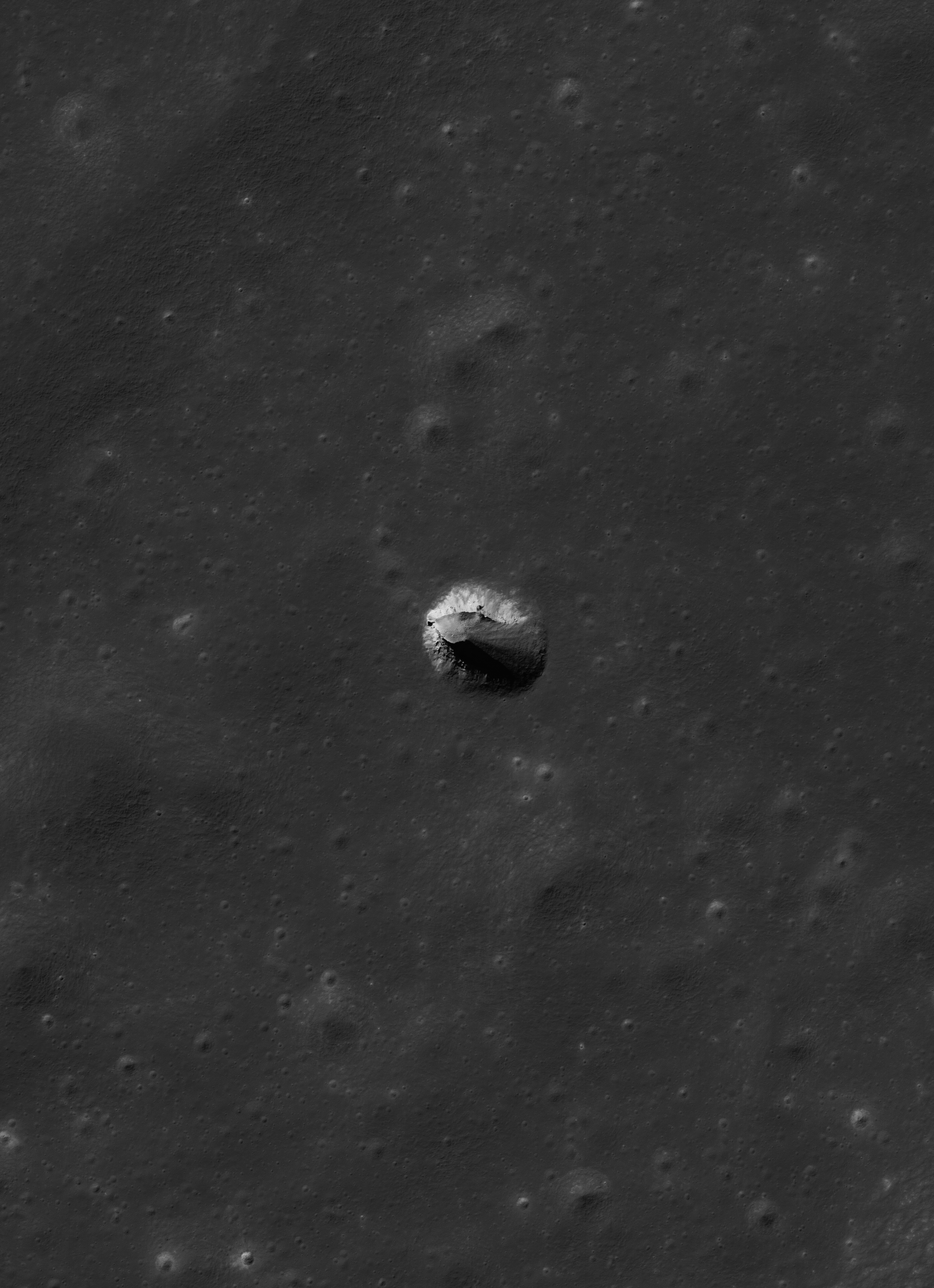
| The same partially collapsed, or filled-in, pit crater in the Rimae Burg region of Lacus Mortis (44.96°N, 25.62°E), from an oblique LROC NAC mosiac M1105701957LR, with spacecraft slewed -41.94° off nadir, orbit 15246, October 24, 2012; 59.78° incidence angle, 2 meters resolution from 155.54 km over 44.92°N, 25.52°E. Explore a full-resolution version HERE [NASA/GSFC/Arizona State University]. |
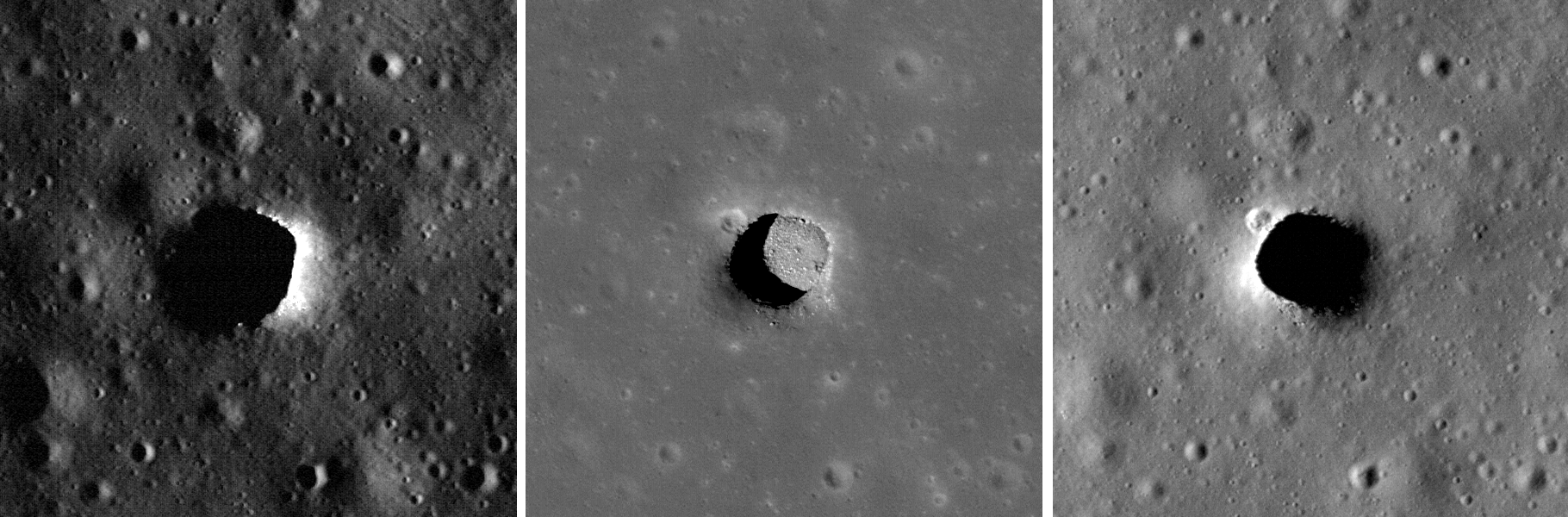
Early in that still-ongoing mission the LROC team at Arizona State University released their own high-resolution NAC images of the Marius Hills Pit, and under a variety of lighting angles, while announcing the discovery of two additional, even larger and more distinctive "pits" in the western interior of Mare Ingenii and the well-preserved example near Sinas J, not far from the vent structures at the west terminus of Rupes Cauchy, in the middle of Mare Tranquillitatis.
These new images left little doubt that significant underground areas existed on the Moon, though how far these sublunarean areas stretched beyond their exposed "skylights," the true scope of the Moon's near-surface underground world, must remain a mystery for some time to come.
These features seemed to be rare and solitary. Rough treatment of the lunar surface, aeons of steady and sometimes heavy bombardment seemed to leave very few of these openings intact. Perhaps the same may be true of extended "lava tubes," and other tantalizing, hoped-for discoveries.
Planetary scientists and geologists have studied the interior walls of these structures. The LROC team has released a high volume of imagery of the Tranquillitatis pit crater, for example, and attempts have been made to map the history of lava inundations recorded in the exposed layers.
|
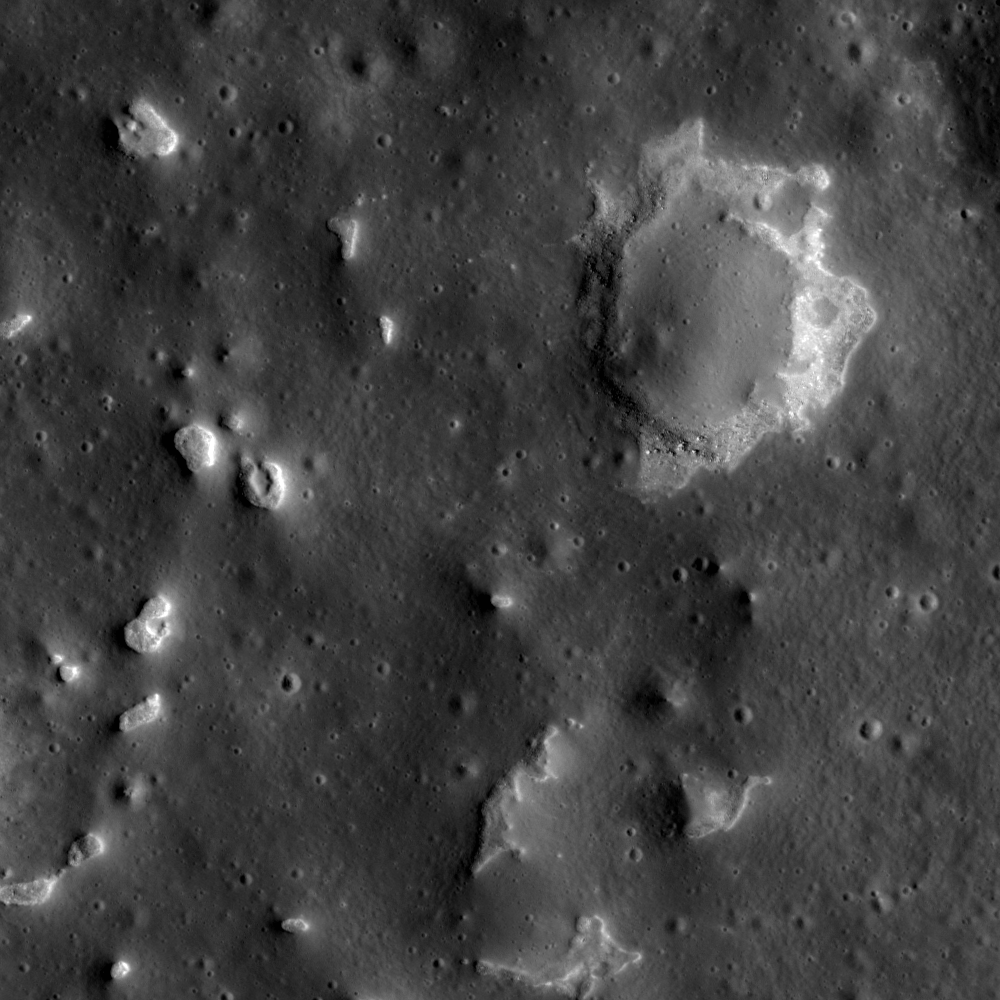
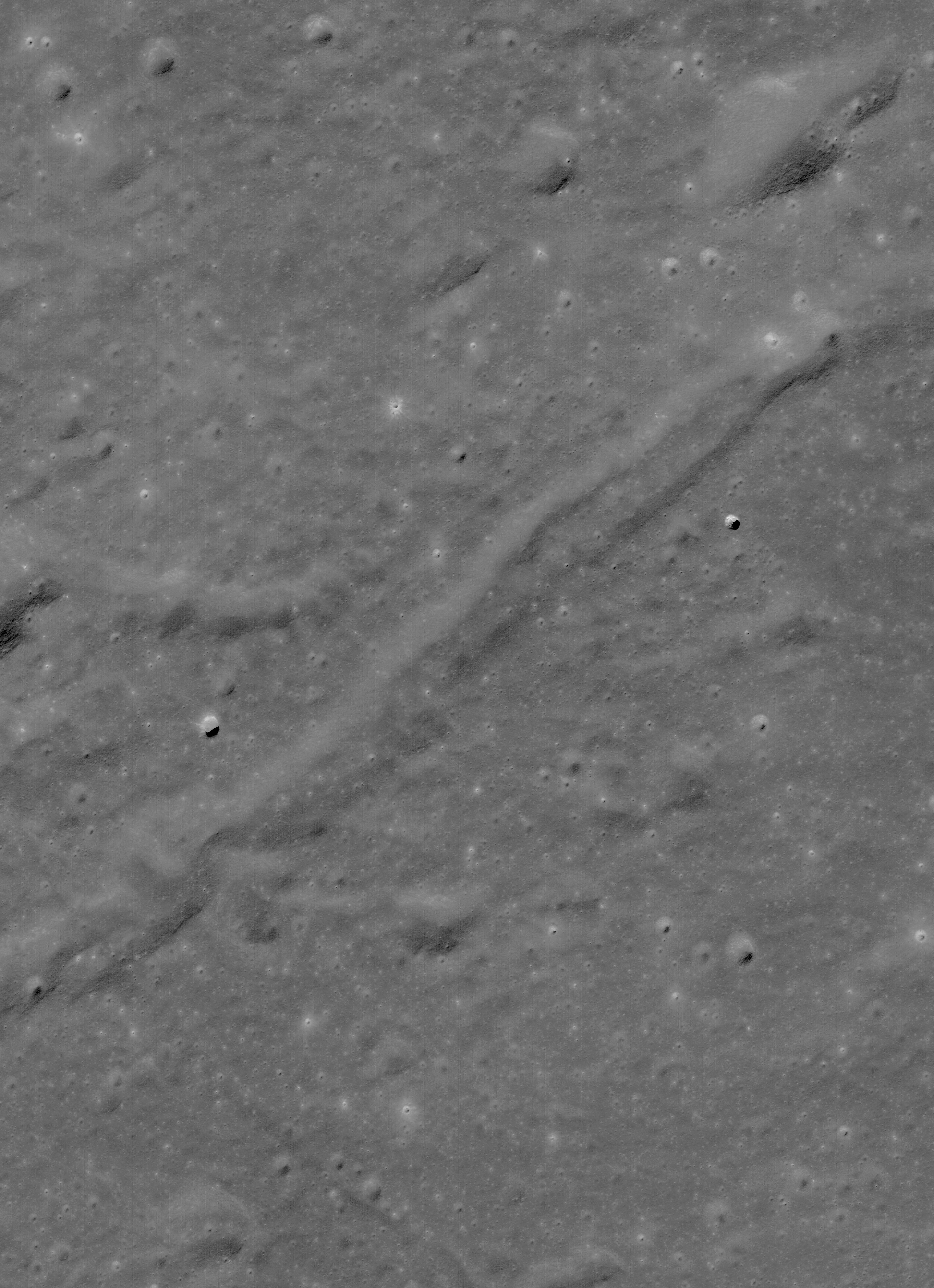
| For a while mare pit craters seemed to be solitary creatures, all alone where they have now been extensively photographed. But the partially filled examples in Lacus Mortis might be near "twins." The 250 meter-wide pit crater above is only 9.7 km southwest of its neighbor (in the first image above - a 13 km walk) from 44.80857°N, 25.21157°E. The view above is from a kilometer-wide field of view from LROC NAC mosaic M122041942LR, orbit 3119, March 1, 2010; 0.5 meters resolution from 46.11 km. (Download the very large original mosaic HERE) [NASA/GSFC/Arizona State University]. |
These features seemed to be rare and solitary. Rough treatment of the lunar surface, aeons of steady and sometimes heavy bombardment seemed to leave very few of these openings intact. Perhaps the same may be true of extended "lava tubes," and other tantalizing, hoped-for discoveries.
Planetary scientists and geologists have studied the interior walls of these structures. The LROC team has released a high volume of imagery of the Tranquillitatis pit crater, for example, and attempts have been made to map the history of lava inundations recorded in the exposed layers.
Following discovery of three, widely dispersed pit craters at Marius, Tranquillitatis and Ingenii, at least two more smaller and much less distinct examples have turned up Mare Fecunditatis and Mare Smythii.
The unique Natural Bridge feature of King Y is a nearly unique example of the much more widespread family of collapse and channel remnants common to impact melts, both inside and outside relatively "recent" impacts, like the northeast quadrant of the interior of Copernicus, for example, and deep inside Messier A. To distinguish these from the Marius-Tranquillitatis-Ingenii family of openings, the latter are now referred to as mare pit craters.
Far from being as widespread as melt channels and collapse pit, the Mare Pit Craters seemed to be solitary, perhaps one to a plain, if any at all. As seems common to all deep space discoveries, however, of course there had to be an exception.
|
| "Twin" Mare Pit Craters, roughly 10 km apart (as the LM ascent stage flies) on opposite sides of the primary channel in the Rimae Burg region, west-central Lacus Mortis. This field of view is 15.72 km across, from LROC MAC mosaic M1105701957LR [NASA/GSFC/Arizona State University]. |
 |
| Lacus Mortis, from the LROC web-based PDS search tool, showing the prior image field of view outlined by a white rectangle. Note the concurrence with a junction zone of the fault and channel constituents of Rimae Burg [NASA/GSFC/Arizona State University]. |
The east-southeast wall of the northeast pit seems to have filled in, like a forgotten entrance to a pharaoh's tomb, though the south interior stays in hard shadow at this latitude. But the north wall offers up a shadow ring where the sun's angle should be well placed for illumination, hinting at an unseen and deeper interior perhaps.
 |
| The perspective from Earth, the area of interest marked by a bright asterisk in west central Lacus Mortis, an eyebrow for the "Man in the Moon" (yellow rectangle in inset). From a First Quarter Moon montage captured April 21, 2010. Photo by Yuri Goryachko, Mikhail Abgarian, Konstantin Mororzov - ASTRONOMINSK, Minsk, Belarus. |
Did these two examples of mare pit craters, perhaps the only such "twins" on the Moon, degrade more quickly because of a greater age than their more noted cousins at Tranquillitatis or Ingenii? Did the arrival of the impact that formed Burg cave them in? Is this area more prone to Moonquakes?
Related Posts:
Pit Crater in Fecunditatis (May 23, 2013)
Copernicus Collapse Pit (March 5, 2013)
Melt pit on the floor of Louville D (August 16, 2012)
Impact melt collapse pit (March 2, 2012)
Failed Skylights of Copernicus (January 24, 2012)
New view of Sinas pit crater (November 11, 2011)
Impact melt collapse pit (March 2, 2012)
Failed Skylights of Copernicus (January 24, 2012)
New view of Sinas pit crater (November 11, 2011)
Layering in Messier A (July 22, 2011)
Sublunarean Void (February 8, 2011)
New views of lunar pits (September 14, 2010)
Sublunarean Void (February 8, 2011)
New views of lunar pits (September 14, 2010)
Natural Bridge on the Moon (September 7, 2010)
Depths of Mare Ingenii (June 16, 2010)
How common are mare pit craters? (July 15, 2010)
Depths of Mare Ingenii (June 16, 2010)
How common are mare pit craters? (July 15, 2010)
Haruyama Cavern in the Marius Hills (March 2, 2010)
Paul Spudis: Caves on the Moon (October 28, 2009)