Showing posts with label Clementine. Show all posts

Monday, February 23, 2015

SDI: Military uses of the Moon and Asteroids (1983)

NASA/DOD joint lunar reconnaissance and instrument test platform Clementine, "lost and gone forever" following its remarkable and successful mission in 1994.
David S.F. Portree
Wired

On the evening of 23 March 1983, President Ronald Reagan addressed the people of the United States from the Oval Office. Citing aggressive moves on the part of the Soviet Union, he defended proposed increases in U.S. military spending and the introduction of new missiles and bombers. He then called for a revolution in U.S. strategic doctrine:

Let me share with you a vision of the future. . .What if free people could live secure in the knowledge that their security did not rest upon the threat of instant U.S. retaliation to deter a Soviet attack, that we could intercept and destroy strategic ballistic missiles before they reached our own soil or that of our allies? I know this is a formidable technical task, one that may not be accomplished before the end of this century. . .I call upon the scientific community in our country, those who gave us nuclear weapons, to turn their great talents now to the cause of Mankind and world peace, to give us the means of rendering these nuclear weapons impotent and obsolete.

Thus was born the Strategic Defense Initiative (SDI), which is perhaps better known by its cinema-inspired nickname “Star Wars.” This post is not meant to discuss the geopolitical ramifications or technical feasibility of SDI. It will instead focus on a lesser-known aspect of SDI planning.

Read the fascinating full story at WIRED, HERE.

Thursday, May 15, 2014

Earth rising

The vastness of space, and the inviting terra firma of Earth and Moon. LROC Featured Image, May 7, 2014. LROC WAC M1145896768C, LRO orbit 20898, February 1, 2014 [NASA/GSFC/Arizona State University].
Paul D. Spudis
The Once and Future Moon
Smithsonian Air & Space

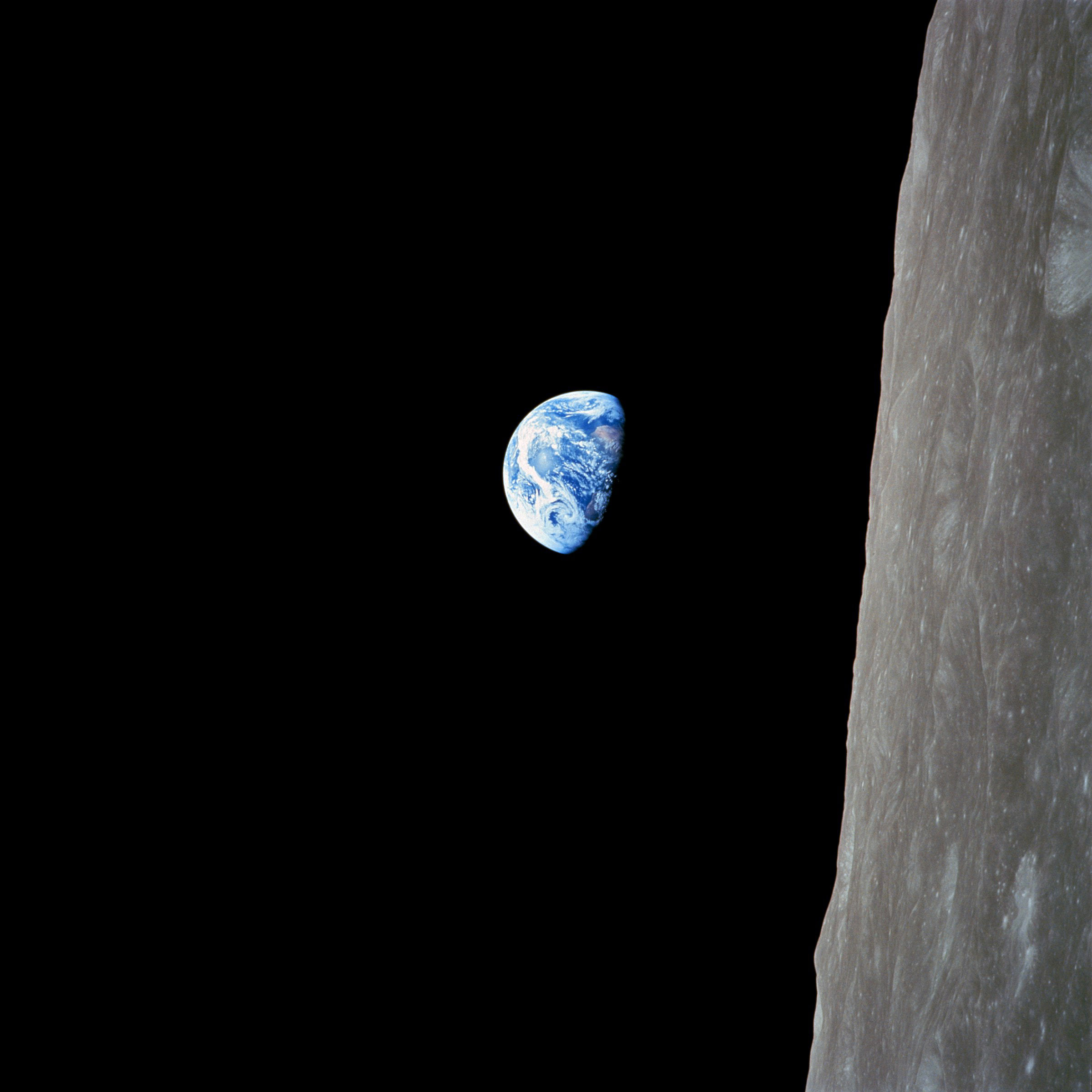
The LRO Camera Team recently released a newly obtained, beautiful image of the Earth above the north pole of the Moon.  In the history of lunar exploration, Earthrise photos have always been widely displayed and admired. Capturing the iconic image of a magnificent blue and white Earth hanging over the barren, gray surface of the Moon is one of the most memorable moments of man’s first flight to the Moon by Apollo 8 in December 1968.

This picture graced the covers of newspapers and magazines everywhere; it inspired a million words of prose and created the modern environmental movement as we know it. Few single images have had such pervasive and lasting power.

Apollo 8's overview effect: Iconic Earthrise image, AS08-14-2383, Bill Anders' serendipitous photograph of Earth as the first manned flight to the Moon swung around from the farside, December 24, 1968 [NASA/JSC].
The Apollo 11 crew landed on the lunar surface a few months after that Earthrise photo was circulated. During this and subsequent missions (all on the central near side of the Moon), it was reported by the media that Earth always appears stationary in the same part of the sky as seen from the Moon’s surface.

In November 1969, the Apollo 12 crew put up a large inverted umbrella antenna to improve communication data rates from the lunar surface; it had to be set-up and aligned, but once pointed at Earth, it remained pointed at it forever.

Simulated time-lapse view of Earth from the vicinity of the Moon's north pole, where the significance of the Moon's libration creates changes in a notional viewers perspective. Earth appears to swing through a Lissajous figure in the sky. Three lunar days are squeezed into 1:45 using Celesta.

Because the Moon orbits the Earth and is in synchronous rotation with its orbital period, we always see the same side.  Hence, there is a near side (the hemisphere we see from Earth) and a far side (the side we cannot see from Earth; it is often mistakenly called the “dark side”).

A consequence of this synchronous rotation is that from the Moon, the Earth appears stationary in the sky, just as the hub of a bicycle wheel remains stationary from the viewpoint of one of its spokes. Thus, while the Sun rises and sets according to the slow rotation rate of the Moon (one complete rotation every 708 hours, half day and half night), the Earth is always in the same spot in the sky. Of course, because it is illuminated by the Sun, it changes its phase on the same timescale as does the Moon as seen from Earth, although reversed (a full Moon on Earth is a new Earth from the Moon and vice versa.)  From the far side of the Moon, one does not see the Earth at all.

Are spectacular views of Earthrise only visible from spacecraft in orbit about the Moon? Not quite.

Two points about the Moon’s orbit make the story a bit more complicated. First, the Moon’s orbit around the Earth is not circular but elliptical, its distance ranging from 363,000 km up to 405,000 km from the Earth. Second, the plane of the Moon’s orbit is inclined about 5 degrees to the ecliptic (the plane of the Earth-Moon system’s orbit around the Sun). These two facts mean that the Moon librates, or “wobbles” both left and right (an effect of its elliptical orbit) and up and down (an effect of the inclination of its orbital plane). These librations are not overwhelmingly significant, but result in some interesting effects around the limb of the Moon – the great circle made up by the 90 degrees east and west longitude lines, including both poles.

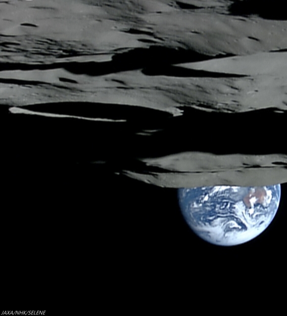
Earthset, from 1080p video captured from Japan's lunar orbiter SELENE-1 (Kaguya) October 31, 2007, as spacecraft and camera, in polar orbit, began its track north from the south pole (on the rim of Shackleton crater, center left) over the Moon's farside, leaving Earth to set behind Malapert massif, a nearside fragment of the rim of immense South Pole-Aitken impact basin [JAXA/NHK/SELENE].
The Earth as seen from the Moon is about 2 degrees in angular width (about 4 times the apparent diameter of the Moon and Sun as seen from Earth). Earth’s disk is roughly equivalent to the size of a quarter held out at arm’s length; the Moon’s apparent disk is pea-sized. Because of the Moon’s longitudinal libration, the “limb” areas near the 90 degree meridians are sometimes visible to Earth and other times not. Thus, the Earth will sometimes appear in the sky and sometimes be hidden below the Moon’s horizon – in other words, an observer along this line of longitude will see an Earthrise and an Earthset.

The longitudinal libration is about 8 degrees, so the observer on the lunar limb would see the Earth slowly rise above the horizon and clear it by its apparent diameter, then slowly sink below the horizon by the same amount. That Earthrise will be slow indeed – it will take a couple of days for the full disk of the Earth to rise above the horizon. This cycle would repeat on a monthly timescale, as the Moon completes one revolution around the Earth.

Similarly, one would also see the Earth rise and set at the poles of the Moon, although to a different magnitude. The polar view is almost completely dominated by the latitudinal libration, caused by the inclination of the Moon’s orbital plane. This variation is about 6.5 degrees (it includes the Moon’s spin axis obliquity of 1.5 degrees) and would vary on a similar monthly timescale. These variations will become important if future lunar inhabitants live at the poles, as I think likely. As the Earth will sometimes be out of direct view, it is likely that we will depend on relay satellites for continuous communication. Polar inhabitants will also see a “different” Sun from what they’re accustomed to on Earth – at the lunar poles, the sun rotates around the horizon, rather than rising and setting.

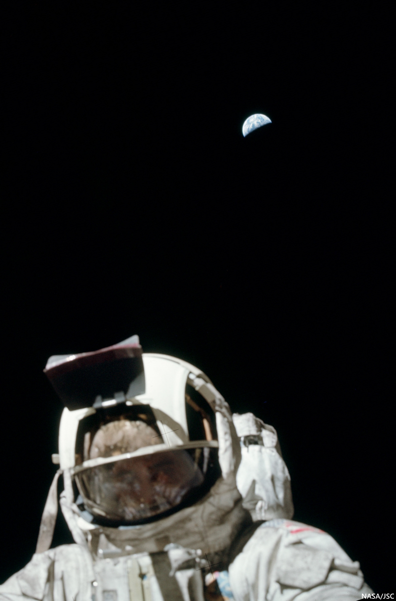
Cernan and Earth. At Taurus Littrow, Earth maintains its position. Ground controllers did occasionally admonished Apollo 17 Cmdr. Gene Cernan's partner Jack Schmidt for lifting his solar visor to get a better look at a rock, from time to time, during the last walks on the Moon. But at this point, however, as he traded poses with Schmidt using Earth as a backdrop, Cernan did briefly lift his visor halfway, allowing posterity an atypical view of an actual human face on the Moon in December 1972 (AS17-134-20471) [NASA/JSC].
Thus, there are places on the Moon from which we can stand and contemplate the sheer beauty and magnificence of a slowly rising Earth. Given the sea change in global perspective provided by the famous Earthrise picture taken by the Apollo 8 crew almost fifty years ago, what societal impacts will occur when a human being stands on the lunar surface and watches the Earth slowly rise above the horizon? I suspect that a similar shift in planetary perspective will occur. If history is any guide, such a shift will have profound psychological and political implications  – both positive and negative – in our reach for the stars.

Dr. Paul D. Spudis is a senior staff scientist at the Lunar and Planetary Institute in Houston. This column was originally published by Smithsonian Air & Space online, and his website can be found at www.spudislunarresources.com. The opinions he expressed here are his own, but these are better informed than most.

Thursday, March 6, 2014

Squarish Lavoisier A of Oceanus Procellarum

Squarish Lavoisier A
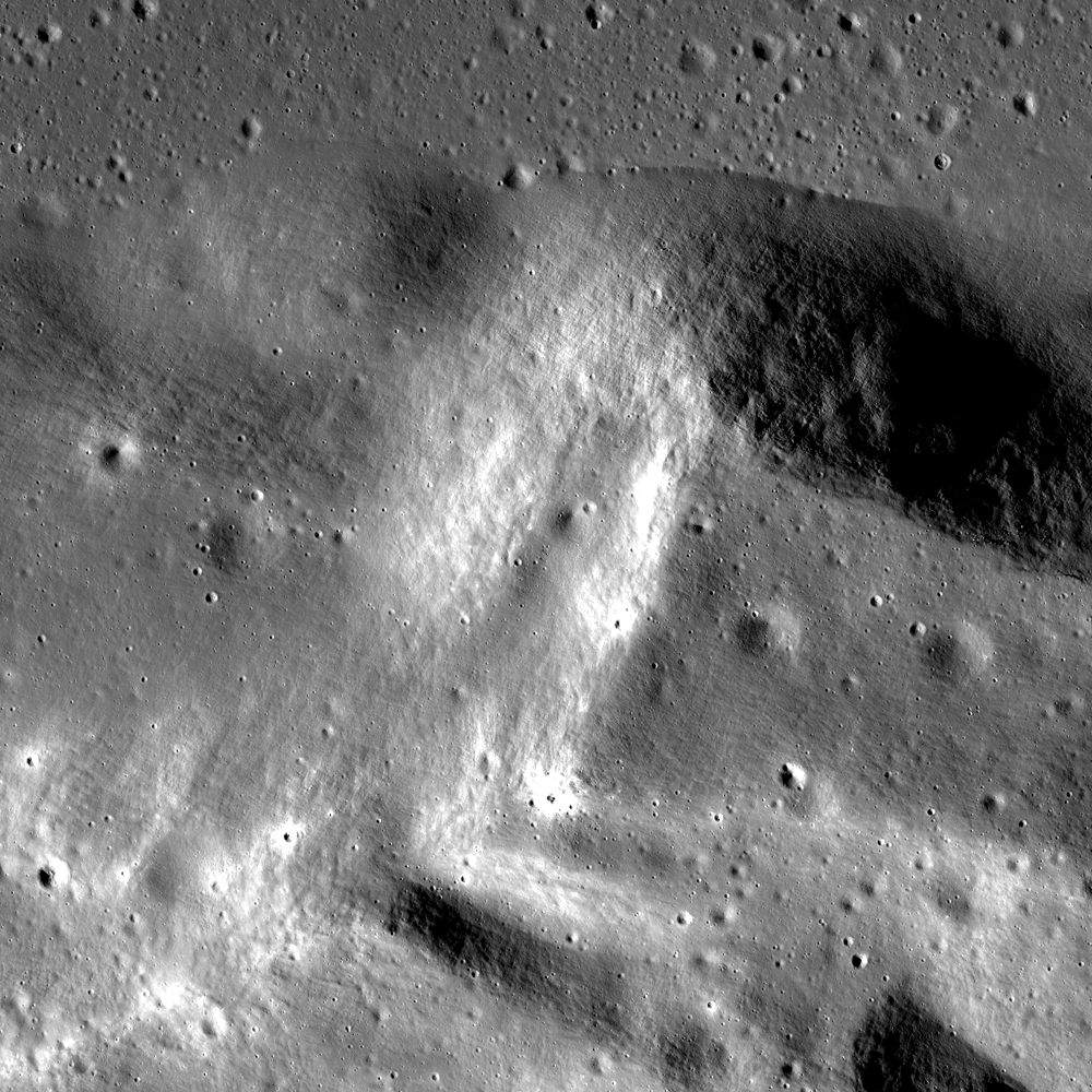
The square corner along the north-most rim of Lavoisier A (28.5 km, 36.972°N, 286.74°E), evidence of pre-impact fracturing. LROC NAC observation M112759713L, spacecraft orbit 18324, July 4, 2014; field of view approximately 7 km, resolution 1.41 meters per pixel. LROC Featured Image, released March 6, 2014 [NASA/GSFC/Arizona State University].
Raquel Nuno
LROC News System

Why are most craters circular (even craters found on Earth)? By hurtling objects together at many miles per second in large laboratories, scientists have shown that only the most oblique impacts (less than 10° from the horizon) produce elliptical craters.

The kinetic energy of an impactor behaves much like the energy from a nuclear bomb. The energy is transferred to the target material by a shock wave, and shock waves produced by an impact, whether oblique or head-on, propagate hemispherically. This shape means that energy is being delivered equally in all directions; resulting in a hemispherical void and thus circular craters. However, conditions in nature do not always mirror the laboratory. In fact some craters are nearly square! A portion of the rim of Lavoisier A crater tells a story of the geology before impact. Lavoisier A is a squareish crater with a diameter of 28.5 km in the northwestern portion of Oceanus Procellarum.

Levoisier A from Chang'e-2
High-reflectance, low-angle illumination incidence view of 28.5 km-wide Lavoisier A from the Chang'e-2 global mosaic, with real color added from the Clementine survey (1994) [Virtual Moon Atlas 5].
Much of Lavoisier A's shape is thought to be due to preexisting joints or faults in the target rock. These discontinuities create zones of weakness, affecting how the shock wave travels through the material. We find square craters on other planetary bodies such as on the asteroid Eros and here on Earth. An example of a square crater that has been thoroughly studied is Meteor Crater in Arizona.

Levoisier A (Astronominsk)
Among the better views of Lavoisier A possible from Earth, situated as it is on the northwest limb of the Moon's nearside, in northwest Oceanus Procellarum, at the direct center of this image from a mosaic by Yuri Goryachko, Mikhail Abgarian and Konstantin Morozov, the Astronominsk team of Minsk, Belarus, sectioned from a full-disk observation photographed September 4, 2012 (below) [Astronominsk].
Levoisier A (Astronominsk)
Lavoisier A is marked with an arrow in the full-disk, 4300 by 4900 mosaic of the waning Moon, September 4, 2012 [Astronominsk].
This crater formed on layers of sedimentary rocks that have orthogonal vertical joints running below where the crater formed. The joints disrupted the shock wave flow in certain directions, preventing the formation of a circular crater. Another indication of weaknesses within the target layers is the appearance of the northeastern portion of the crater rim. It appears as if a layer of rock has been peeled back.

Can you find the evidence of pre-impact fracturing (square boundaries) in the full resolution NAC, HERE?

Related Posts:
Squished Crater
Four of a Kind in Catena Davy

Tuesday, January 21, 2014

Clementine - The Legacy, Twenty Years On

Engineering model of the Clementine spacecraft in the Lunar Exploration Vehicles exhibit at the National Air and Space Museum. Interstage and solid rocket motor (bottom half) was discarded before insertion into lunar orbit.
Paul D. Spudis
Smithsonian Air & Space

The first spacecraft to globally map the Moon left lunar orbit on May 3, 1994.  Clementine, a joint Department of Defense-NASA mission, had systematically mapped the Moon’s surface over 71 days, collecting almost 2 million images.  For the first time, scientists could put results of the Apollo lunar sample studies into a regional, and ultimately, a global context.  Clementine collected special data products, including broadband thermal, high resolution and star tracker images for a variety of special studies.  But in addition to this new knowledge of lunar processes and history, the mission led a wave of renewed interest in the processes and history of the Moon, which in turn, spurred a commitment to return there with both machines and people.  We peeked into the Moon’s cold, dark areas near the poles and stood on the edge of a revolution in lunar science.

Prior to Clementine, good topographic maps only existed for areas under the ground tracks of the orbital Apollo spacecraft.  From Clementine’s laser ranging data, we obtained our first global topographic map of the Moon.  It revealed the vast extent and superb preservation state of the South Pole-Aitken (SPA) basin and confirmed many large-scale features mapped or inferred from only a few clues provided by isolated landforms.  Correlated with gravity information derived from radio tracking, we produced a map of crustal thickness, thereby showing that the crust thins under the floors of the largest impact basins.

Two cameras (with eleven filters) covered the spectral range of 415 to 1900 nm, where absorption bands of the major lunar rock-forming minerals (plagioclase, pyroxene and olivine) are found.  Varying proportions of these minerals make up the suite of lunar rocks.  Global color maps made from these spectral images show the distribution of rock types on the Moon.  The uppermost lunar crust is a mixed zone, where composition varies widely with location.  Below this zone is a layer of nearly pure anorthosite, a rock type made up solely of plagioclase feldspar (formed during the global melting event that created the crust).  Craters and large basins act as natural “drill holes” in the crust, exposing deeper levels of the Moon.  The deepest parts of the interior (and possibly the upper mantle) are exposed at the surface within the floor of the enormous SPA basin on the far side of the Moon.

Topographic map of the Moon made from Clementine laser altimetry in mid-latitudes and stereo images near the poles. Large depression in southern far side is the South Pole-Aitken basin.
Clementine showed us the nature and extent of the poles of the Moon, including peaks of near permanent sun-illumination and crater interiors in permanent darkness.  From his first look at the poles, Gene Shoemaker (Leader of the Clementine Science Team) got an inkling that something interesting was going on there.  Gene was convinced that water ice might be present, an idea about which I had always been skeptical.  At that time, no trace of hydration had ever been found in lunar minerals and the prevailing wisdom was that the Moon is now and always had been bone dry.  With Gene arguing to keep an open mind and Stu Nozette (Deputy Program Manager) devising a bistatic radio frequency (RF) experiment to use the spacecraft transmitter to “peek” into the dark areas of the poles, we moved ahead on planning the observations.

To my astonishment (and delight), a pass over the south pole of the Moon showed evidence for enhanced circular polarization ratio (CPR) – a possible indicator of the presence of ice.  A control orbit over a nearby sunlit area showed no such evidence.  However, CPR is not a unique determinant for ice, as rocky, rough surfaces and ice deposits both show high CPR.  It took a couple of years to reduce and fully understand the data, but collection of the bistatic collection was successful.  In part, our ice interpretation was supported by the discovery of water ice at the poles of Mercury (a planet very similar to the Moon).  We published our results in Science magazine in December 1996, setting off a media frenzy and a decade of scientific argument and counter-argument about the interpretation of radar data for the lunar poles (an argument that continues to this day, despite subsequent confirmation of lunar polar water from several other techniques).

Along with Clementine’s success came a growing interest in lunar resources and a new appreciation for the complexity of the Moon.  This interest led to the selection of Lunar Prospector (LP) as the first PI-led mission of NASA’s new, low-cost Discovery series of planetary probes.  LP flew to the Moon in 1998 and carried instruments complementary to the data produced by Clementine, including a gamma-ray spectrometer to map global elemental composition, magnetic and gravity measurements, and a neutron spectrometer to map the distribution of hydrogen.  LP found enhanced concentrations of hydrogen at both poles, again suggesting that water ice was probably present.  The debate on the abundance and physical nature of the water ice continued, with estimates ranging from a simple enrichment of solar wind implanted hydrogen in polar soils, to substantial quantities of water ice trapped in the dark, cold regions of the poles.

Buttressed by this new information, the Moon became an attractive destination for robotic and human missions.  With direct evidence for significant amounts of hydrogen (regardless of form) on the surface, there now was a known resource that would support long-term human presence.  This hydrogen discovery was complemented by the identification in Clementine images of several areas near the pole that remain sunlit for substantial fractions of the year – not quite the “peaks of eternal light” first proposed by French astronomer Camille Flammarion in 1879 but something very close to it.  The availability of material and energy resources  – the two biggest necessities for permanent human presence on the Moon – was confirmed in one fell swoop.  Combined, the results of Clementine and LP finally gave scientists the Lunar Polar Orbiter mission we had long sought.  These two missions certified the possibility of using lunar resources to provision ourselves in space, permanently establishing the Moon as a valuable, enabling asset for human spaceflight.  Remaining was to verify and extend the radar results from Clementine and map the ice deposits of the poles.

The Clementine bistatic experiment led to the development of an RF transponder called Mini-SGLS (Space Ground Link System), which flew on the Air Force mission MightySat II in 2000.  This experiment miniaturized the RF systems necessary for a low mass, low power imaging radar.  With the 2008 inclusion of our Mini-SAR on India’s Chandryaan-1 lunar orbiter, we finally got the chance to build and fly such a system.  Chandrayaan-1 not only mapped the high CPR material at both poles, it also carried a spectrometer (the Moon Mineralogy Mapper, or M3) that discovered large amounts of adsorbed surface water (H2O) and hydroxyl (OH) at high latitudes.  Coupled with the measurement of exospheric water above the south pole by its Moon Impact Probe, Chandrayaan-1 significantly advanced our understanding of polar water, revealing it to be abundant and present in more varied forms on the Moon than had previously been imagined.

Mosaic of Clementine images of the south pole of the Moon. Dark regions contain water ice and small areas near pole are sunlit for significant fractions of the lunar day.
The ever increasing weight of evidence for the presence of significant amounts of water at the lunar poles led to the LCROSS experiment being “piggybacked” on NASA’s 2008 Lunar Reconnaissance Orbiter (LRO) mission.  LCROSS was a relatively inexpensive add-on, designed to observe the collision of the LRO launch vehicle’s Centaur upper stage with the lunar surface, looking for water in the ejecta plume of that impact.  Water in both vapor and solid form was observed, suggesting the presence of water ice in the floor of the crater Cabaeus (at concentration levels between 5 and 10 weight percent).  LRO orbits the Moon and collects data to this day.  Although much remains unknown about lunar polar water, we now know for certain that it exists; such knowledge has completely revised our thinking about the future use and habitation of the Moon.

The Clementine programmatic template has influenced spaceflight for the last 20 years.  The Europeans flew SMART-1 to the Moon in 2002, largely as a technology demonstration mission with goals very similar to those of Clementine.  NASA directed the Applied Physics Laboratory (APL) to fly Near-Earth Asteroid Rendezvous (NEAR) to the asteroid Eros in 1995 as a Discovery mission, attaining the asteroid exploration opportunity missed when control of the Clementine spacecraft was lost after leaving the Moon.  India’s Chandrayaan-1 was of a size and payload scope similar to Clementine.  The selection of LCROSS as a low-cost, fast-tracked, limited objectives mission further extended use of the Clementine paradigm.

The “Faster-Better-Cheaper” mission model, once panned by some in the spaceflight community, is now recognized as a preferred mode of operations, absent the emotional baggage of that name.  A limited objectives mission that flies is more desirable than a gold-plated one that sits forever on the drawing board.  While some missions do require significant levels of fiscal and technical resources to attain their objectives, an important lesson of Clementine is that for most scientific and exploration goals, “better” is the enemy of  “good enough.”  Space missions require smart, lean management; they should not be charge codes for feeding the beast of organizational overhead.  Clementine was lean and fast; perhaps we would have made fewer mistakes had the pace been a bit slower, but overall the mission gave us a vast, high-quality dataset, still extensively used to this day.  The Naval Research Laboratory transferred the Clementine engineering model to the Smithsonian in 2002.  The spacecraft hangs today in the Air and Space Museum, just above the Apollo Lunar Module.

It is probably not too much of an exaggeration to say that Clementine changed the direction of the American space program.  After the failure of SEI in 1990-1992, NASA was left with no long-term strategic direction.  For the first time in its history, NASA had no follow-on program to Shuttle-Station, despite attempts by Dan Goldin and others to secure approval for a human mission to Mars (then and now, a bridge too far – both technically and financially).  This programmatic stasis continued until 2003, when the tragic loss of Columbia led to a top-down review of U.S. space goals.  Because Clementine had documented its strategic value, the Moon once again became an attractive destination for future robotic and human missions.  The resulting Vision for Space Exploration (VSE) in 2004 made the Moon the centerpiece of a new American effort beyond low Earth orbit.  While Mars was vaguely discussed as an eventual (not ultimate) objective, the activities to be done on the Moon were specified in detail in the VSE, particularly with regard to the use of its material and energy resources to build a sustainable program.  Regrettably, various factors combined to subvert the Vision, thereby ending the strategic direction of America’s civil space program.

Clementine was a watershed, the hinge point that forever changed the nature of space policy debates.  A fundamentally different way forward is now possible in space – one of extensibility, sustainability and permanence.  Once an outlandish idea from science fiction, we have found that lunar resources can be used to create new capabilities in space, a welcome genie that cannot be put back in the bottle.  Americans need to ask why their national space program was diverted from such a sustainable path.  We cannot afford to remain behind while others plan and fly missions to understand and exploit the Moon’s resources.  Our path forward into the universe is clear.  In order to remain a world leader in space utilization and development – and a participant in and beneficiary of a new cislunar economy – the United States must again direct her sights and energies toward the Moon.

Note: Background history for the Clementine mission is described in a companion post at my Spudis Lunar Resources blog, HERE.

Originally published at his Smithsonian Air & Space blog The Once and Future Moon, Dr. Spudis is a senior staff scientist at the Lunar and Planetary Institute. The opinions expressed are those of the author but are better informed than average.

Wednesday, January 15, 2014

Hansteen α

Hansteen α (LROC NAC)
Close up on the heights (-923.8 elev.) of Hansteen α (AKA, "Mons Hansteen" and "the Arrowhead"), a triangular berg, 25 km long on its three margins, composed of intrinsically bright material and rising here 1030 meters above its neighborhood in south Oceanus Procellarum.  LROC Narrow Angle Camera (NAC) periapsis observation M166175569LR, spacecraft orbit 9623, July 24, 2011; 61.74° incidence, slew 16.45° west, resolution 0.5 meters from 41.05 km (Enlarged image HERE.) [NASA/GSFC/Arizona State University].
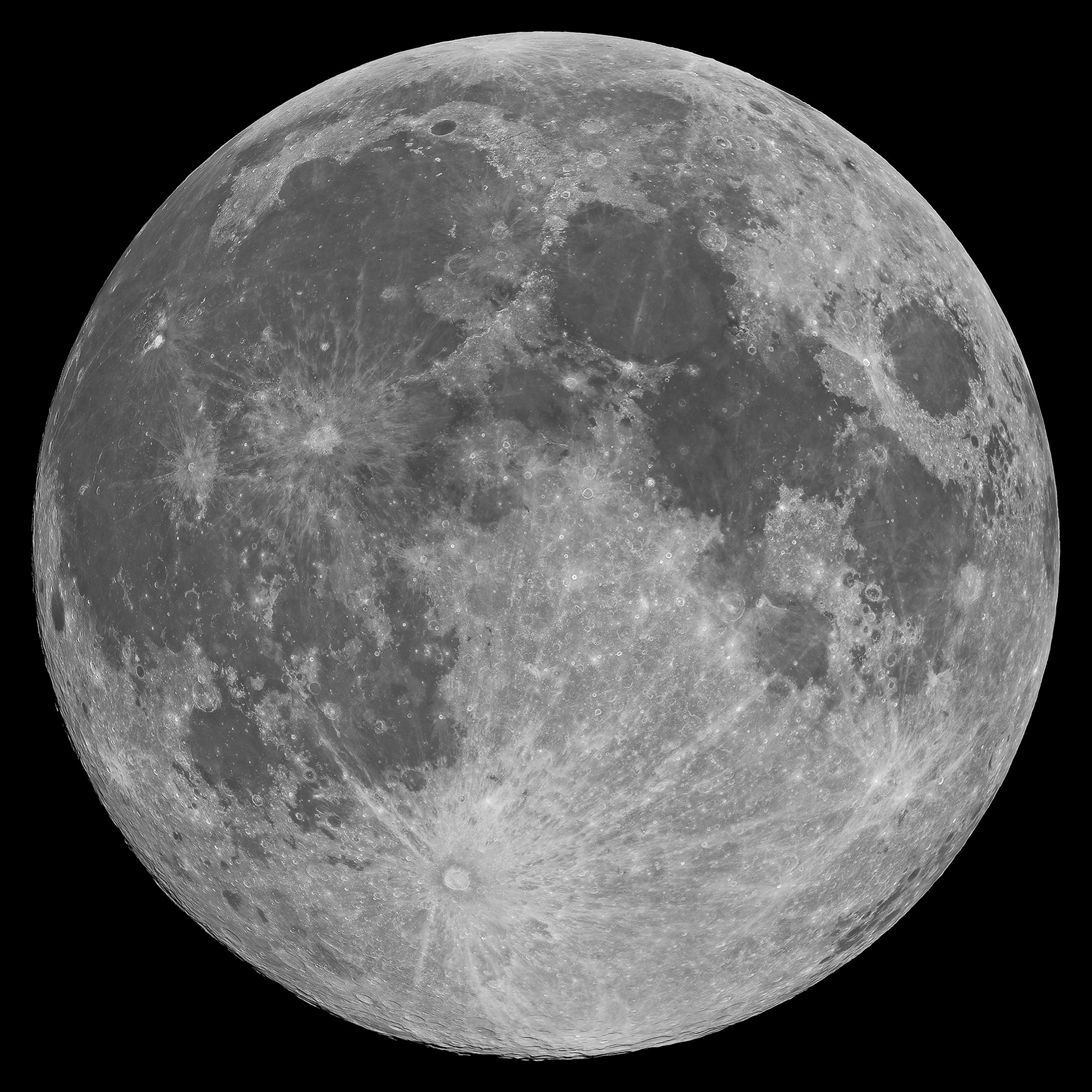
Mons Hansteen (12.2°S, 50.21°W) is a familiar nearside landmark, when viewing a Moon that's almost Full through a modest telescope. As the reader can see in the picture of the Full Moon at the end of this post, it stands out from its surroundings in the far south Oceanus Procellarum.

It's nicknamed "the arrowhead" because it looks like one, like, long-ago, it was knapped to a point by the patient hand of a hunter and now rests half buried in the darker mud of a trail, perhaps uncovered by a recent downpour.

Close investigations of the Moon over the past half century reveal what investigators call "Hansteen Alpha," or Hansteen α, stands out geologically and in other ways. The small mountain is made of different stuff than most of what is found on the lunar surface and the volcanism that flooded and re-flooded the Moon's basins. It's optical brightness is complimented by differences at other wavelengths as well, presenting a spectral profile found in only a few other locations on the Moon. 

Hansteen α is one of the Moon's red spots, bright with an albedo similar to the lunar highlands but spectrally red, brighter in shorter wavelengths and characterized by absorption in the ultra-violet (UV). 

Moreover, it must be a younger feature than it might seem on first glance, younger than certain of the larger craters nearby and other features in its neighborhood that were clearly overrun repeatedly by the darker basaltic lavas that periodically flooded and re-flooded the lower elevations over a period nearly three billion years long.

Hansteen α (LROC NAC)
The heights in the first image are at lower right in this 3.94 km-wide field of view, the full width of the area captured from LRO in LROC NAC M166175569LR, and showing a cross-section of Hansteen α from that central area north to more lower elevations, nearer the mountain's northwestern margin. (View larger sizes HERE.) [NASA/GSFC/Arizona State University].
Hansteen a (LROC WAC 250m)
Hansteen α is younger than craters Billy (45.57 km across and 3.88 billion years old, to the south) and Hansteen (45 km across and 3.87 billion years old, to the west), because both are less than one and a half times their respective diameters in distance, and the impacts that excavated these features should have at least partially covered the bright mountain. Instead, no evidence of such a direct effect has been found, only peppering of more recent impacts. LROC Quickmap at 250 meters resolution [NASA/GSFC/Arizona State University].
Hansteen α resembles the Moon's highlands but, beginning early in the post-Apollo era, investigators noted differences in texture, color and measured albedo. In the close-ups at the beginning of this post, showing some of the highest elevations of Hansteen α, depressions can be seen clustered on terraces. These seem to have once been volcanic vents.  Volcanic vents are not particularly rare on the Moon, but the kind of material that emerged from these is clearly not the same stuff that flooded its surroundings.

LROCQM064-H-a-580x746
A closer look at Hansteen α elevations, with locations marked of areas shown in LROC NAC observations posted here, the highest elevations and, further along along, some solidified flows on the steep southeastern margin, included below. LROC Quickmap at 64 meters resolution, together with the LROC WAC-derived digital terrain model [NASA/GSFC/Arizona State University].
Using an experimental 3D visualization tool, accessed through the LROC Quickmap. a 152 square km area, centered on Hansteen α, animated between 0 and 10 X vertical exaggeration, further illustrating highest elevations, southwest of the formation's center; something more difficult to measure using 2D overhead photography [NASA/GSFC/Arizona State University].
The margins of Hansteen α seem abrupt, with steeper slopes than is found around the edges of the more common basaltic domes. This might be in keeping with suggestions that the kind of lava emerging into and out of this feature was thicker, related to its composition and the heat necessary for melting and transport. It also provides geologists with clues about its age relative to the volcanism that flooded Procellarum in this region.  

The Hansteen α might have formed from a "secondary," and "more evolved" volcanism, something certainly less common than the basaltic lavas that flowed out into the Moon's broad basins, not once but repeatedly, over a 2.7 billion year period, from the Nectarian age, when the Moon and Earth were only 600 million years old, until just prior to the Copernican period 1.2 billion years ago.

These more recent high-resolution images from LRO show groupings of blocky boulders, mostly related to mass wasting along slopes though some of these clusters are found on level areas and don't appear to be the result of impacts.

Intrusive volcanism Hansteen Alpha
An intrusive flow, clearly visible on the abrupt southeastern margin of Hansteen alpha,  right where it solidified, This is a 3.93 km square field of view from LROC NAC observation M1129816872R, orbit 18636, July 30, 2013; 42.35° incidence, 80 cm per pixel resolution from 80.7 km over 12.2°S, 310.14°E  [NASA/GSFC/Arizona State University].
Intrusive volcanism Hansteen Alpha
Contextual view of the full 7.8 km-wide field of view swept up in the same LROC NAC  observation, showing a wider view of southeast margin of Hansteen α. Such close-ups reveal that the margin here is more abrupt than it seems at a distance. (Enlarged views and various other sizes available HERE.) [NASA/GSFC/Arizona State University].
So, just what is Hansteen alpha? In two papers presented in 2011 and 2012 to the Lunar and Planetary Science Conference, Hawke, et.al., representing some of the more noted investigators working with data returned from LRO (the more recent of these being  "The Geology and Composition of Hansteen Alpha," 43rd Lunar and Planetary Science Conference (2012), #1754), wrote, "Non-mare volcanism is the only viable process for the formation of Hansteen α."

That paper, along with others those investigators cite, along with still others cited as references below, present truly fascinating discussion of how instruments on-board Clementine (1994), Lunar Prospector (1998-99) and both the LROC cameras and the Diviner instrument, flying on LRO since 2009, are actively being used to weed out the history of this unique feature and how it relates to the complicated volcanic stratigraphy of the Procellarum basin.

Finding Hansteen alpha (Mons Hansteen)
Finding Hansteen α through a modest telescope is relatively easy, from about four days after First Quarter through three days after Last Quarter, on the south edge of Oceanus Procellarum, as shown in this well-crafted mosaic by Stephan Lammel. Look for it left of center in the inset and in the Full Moon, above.
References:

Related ASU LROC Posts:
The Fourth Marian Dome (April 17, 2013)
Aristarchus Spectacular! (December 26, 2011)
Silicic volcanism on the Moon (February 14, 2011)

Monday, April 8, 2013

The Mystery of Shackleton Crater

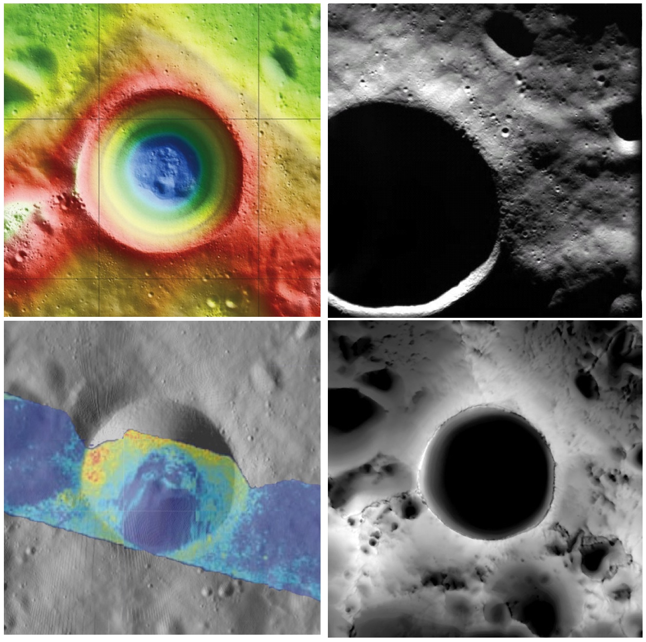
Shackleton crater, Earth's Moon. Clockwise from top left: topography from (LOLA) laser altimetry, photography from ESA SMART-1 mission, lighting map (relative isolation - brighter indicates longer periods of illumination) from LROC data, Mini-RF Circular Polarization Ratio (CPR) image draped over shaded relief. The crater is about 20 km across.
Paul D. Spudis
The Once and Future Moon
Smithsonian Air & Space


Though unremarkable in appearance compared to the roughly 4,000 craters on the Moon in its size range, the 20 km diameter crater Shackleton has been the source of relentless scientific controversy for the past 20 years.  Shackleton is located at the south pole of the Moon; indeed, its near side rim is the precise location of the geographic pole itself.   Its location makes observation by Earth-based telescopes difficult and it was not well photographed by the Lunar Orbiter series (our principal source of lunar images) of the 1960s.  That all changed in 1994 with the flight of the joint DoD-NASA mission to the Moon, Clementine.

Clementine carried cameras that globally imaged the Moon in eleven visible and near-infrared wavelengths.  In addition, it mapped the surface and lighting of the poles of the Moon at uniform resolution over the course of almost three lunar days (74 Earth days).  When the Science Team first saw the south polar mosaic, the extent of darkness in the map was striking.  Because the Moon’s spin axis is close to perpendicular to the ecliptic plane, the Sun is always at the horizon at the lunar poles.  Instead of rising and setting, the Sun circles around the poles at or near the horizon.  Because of this grazing incidence, an area in a topographic depression may be in permanent shadow.  And so it appeared for Shackleton crater in the Clementine data, setting off bells in the heads of the Science Team.

Intuitive selection from HDTV still frame captured by Japan's lunar orbiter SELENE-1 (Kaguya) in 2008 shows Shackleton, with the Moon's south pole on its rim (upper left) in relation to Earth and Malapert Massif, part of the nearside rim of the ancient South Pole-Aitken impact basin, along the line of sight. Shackleton's interior and the craters between it and Malapert, are permanently shadowed interiors (PSR), unmapped before the 21st century [JAXA/NHK/SELENE].
A key controversy of the post-Apollo era was whether the lunar poles might contain water or not.  Although the Apollo samples had been studied and found to be “bone-dry,” we had not been to the poles on any Apollo mission.  We knew that any shadowed areas had to be extremely cold as well as permanently dark.  As water-bearing debris in the form of asteroids and comets constantly strike the Moon, it was thought that some of that water might get into a polar “cold trap” and would be kept there (essentially) forever – billions of years of impacting cosmic “debris” can add up.

Clementine was not configured to measure the presence of water, but a cleverly improvised experiment used the spacecraft’s data transmitter to beam radio waves into the dark regions near the poles and listen to their reflected echoes on the enormous (70 m) dish antenna of NASA’s Deep Space Network.  Interestingly, the reflections indicated an enhancement of “same sense” polarization within the (very large) resolution cell that contained Shackleton crater.  A collect of data from a nearby sunlit area (taken as an experimental control) did not show this peak.  The Clementine team interpreted the RF peak as evidence for the presence of a few percent water ice within the dark, cold interior of Shackleton crater.  The media quickly spread the startling news about water on our “bone-dry” Moon.

Shackleton, as seen in a joint 70 mm radar experiment collected by radio telescopes at Greenbank and Arecebo during a favorable libration opportunity in 2006.
Such a controversial conclusion did not go unchallenged.  Some in the radar community argued that abundant wavelength-sized rocks on the surface were the source of the enhanced same sense reflection.  Since the lunar surface is indeed rocky, this interpretation could not be ruled out.

Then a few years later, the Lunar Prospector (LP) mission found an enhancement of hydrogen concentration at both poles of the Moon; as hydrogen is a major constituent of water, the idea ice exists in the dark areas gained credence and has lead to a decade-long scientific search (using a variety of techniques) for lunar polar ice.  Though many areas near the poles were studied in detail, attention continued to be drawn back to Shackleton and the area near the south pole.

From studying Clementine images, we discovered that part of the rim crest of Shackleton is one of the most sunlit areas on the Moon.  Now we had a double-attraction: constant sunlight with water ice nearby.  At a press briefing in 1996, I called this area of water and sunlight “the most valuable piece of real estate in the Solar System.” Nothing found subsequently has changed my mind on that judgment.

So what have we learned about Shackleton lately?  Many different, new sensors have flown to the Moon in the last few years, including radar, ultraviolet (UV) imaging, laser reflections, and low-light level imaging.  And yet again, Shackleton crater continues to confound us with contradictory evidence, both for and against the presence of water ice in its interior.

In 2009, the question regarding the presence of water ice somewhere near the lunar south pole was answered when the LCROSS impactor threw up a cloud of water vapor and ice particles during its collision with the floor of the nearby crater Cabaeus.  Spectral mapping instruments on three different spacecraft (Chandrayaan-1, Cassini, and EPOXI) documented the presence of adsorbed water on the lunar surface, increasing in concentration with latitude toward both poles.  A small impact probe flown by India (MIP) passed through a water vapor zone in the exosphere just above the lunar south pole.  And radar images from Mini-RF, our radar imaging experiment on both Chandrayaan-1 and Lunar Reconnaissance Orbiter (LRO), found evidence of high same sense reflections (just as Clementine had suggested in 1994) within the interior of Shackleton crater.

LRO Mini-RF instrument radar data indicate the walls of Shackleton crater may, indeed, hold ice, confirming exacting measurements of laser altimeter (LOLA) point brightness studies revealed in June. Actual observations (CPR) are compared to calculated radar values for 0.5% to 10% ice. Illustration to post "Mini-RF adds to evidence of ice on Shackleton walls," September 1, 2012 [NASA ].
These new lines of supporting evidence were countered by Japanese researchers, whose Kaguya spacecraft imaged the interior of the crater and found morphology similar to other lunar craters in the same size-class.  But no one had ever claimed that the interior of Shackleton was a skating rink of pure ice – the lunar polar ice is partly covered by waterless dust and mixed with an unknown amount of dry regolith.

Interpretation of the new data continues to vex us.  The LOLA (laser altimeter) team on LRO recently published a paper that documents the high reflectivity (at 1 micron wavelength) of the walls of Shackleton.  Although the team’s favored interpretation is that this is caused by a constant exposure of fresh material on a steep slope, they also note that it is consistent with the presence of water ice on the walls of the crater.

In addition, a team analyzing neutron spectrometer data from both LP and LRO found evidence in the fast neutron data (never before analyzed) that water in the interior of Shackleton is a possible explanation for its signal.  Detailed analysis of the Mini-RF data for Shackleton corrected for its steep wall slopes and found that the presence of 5-10 wt.% water there provides the best model fit to the observed data.  Newly obtained UV images from LRO show the existence of water frost in the interiors of the craters Haworth and Shackleton, and the neutron detector on LRO shows enhanced hydrogen within both Shoemaker and Shackleton craters.  The Japanese team from Kaguya continue to insist that the no-ice interpretation is the correct one.

So we are left with a mystery.  Some evidence is pro-ice and some is contra-ice.  I find it interesting that for most of the investigators, new data does not necessarily change any minds, but tends to be interpreted in a way most favorable to their previously published ideas.  This should not be terribly surprising; the people who have argued for some specific interpretation presumably did so for good reasons and desire hard and clear-cut evidence to the contrary before abandoning a previously held position, one no doubt reached after much thought and soul-searching.

Less so, but still-mysterious Shackleton, "twice as deep as the Grand Canyon," from "Tour of the Moon," a 2:30 video prepared by the Science Visualization Studio (SVS) at Goddard Space Flight Center in 2012 [NASA/GSFC/SVS].
The way to unravel the water-ice mystery is to go to the surface of the lunar south pole (or both poles) and measure the composition of the surfaces in question.  Getting a definitive answer about the nature of lunar water would be game changing.   Some say the bigger mystery is:  Why hasn’t the United States sent a rover to the south pole of the Moon to take a closer look?

Originally published April 8, 2013 at his Smithsonian Air & Space blog The Once and Future Moon, Dr. Spudis is a senior staff scientist at the Lunar and Planetary Institute. The opinions expressed are those of the author but are better informed than average.

Related Posts:
Mini-RF adds to evidence of ice on Shackleton walls (September 1, 2012)
Shackleton harbors ice after all (June 12, 2012)
1000 Day Anniversary of LROC Imaging (March 27, 2012)
Shackleton on a Summer's Day (March 26, 2012)
Shadowed fluffy lunar frost detected in starlight (January 14, 2012)
Shackleton: Out of the Shadows (September 17, 2009)

Friday, June 1, 2012

Who discovered water on the Moon?

Wishing well? The last direct lunar sample was retrieved by the Soviet Luna 24 robotic lander, August 18, 1976. In total darkness, the descent stage landed on rim of this 64 meter crater, on the southeastern volcanic plains of Mare Crisium (12.717°N, 62.222°E), where it was imaged by the LROC Narrow Angle Camera last fall. Enlargement of lander at lower left, LROC NAC observation M174868307L, LRO orbit 10904, November 2, 2011; resolution 43 cm per pixel from 25.57 kilometers [NASA/GSFC/Arizona State University].
Paul D. Spudis
The Once and Future Moon
Smithsonian Air & Space
< /br>
A recent article tells how Soviet scientists studying regolith samples returned from the Moon in 1976 by the unmanned Luna 24 mission first discovered lunar water.  This assertion is based on a paper published in the Russian journal Geokhimiia (vol. 285, p. 285-288, February 1978).  The measurement used infrared absorption spectroscopy to look for the “water band” centered around 2.8 microns, the same technique used recently by several groups to map the water band on the lunar surface regionally from flyby (Cassini and EPOXI) and orbital (Chandrayaan-1) spacecraft.  The Soviet paper claimed to detect water at a level of about 0.1 weight percent.  This high concentration level of water raised my antennae.

The discovery of significant amounts of water would tell us about lunar processes and history as well as provide evidence that water might be manufactured on the Moon to support future exploration.  The first lunar samples returned to Earth in 1969 by the Apollo 11 mission were intensely scrutinized for water content.  Besides being exceedingly dry, the chemistry of the Apollo samples suggested they were created in a completely anhydrous, reducing environment.  Samples from subsequent missions confirmed and extended this initial impression to the point where talk of water on the Moon was mostly dismissed.

A rock returned in 1972 by the Apollo 16 mission displayed visible brownish splotches which turned out to be “rust” in the form of the mineral akaganeite, an iron-hydroxyl phase, with minor amounts of chlorine.  This mineral could have formed by the aqueous alteration of the iron-chlorine mineral lawrencite found in some meteorites.  However a source of water is still needed to create the “rust,” so for several years the source of the water and the nature of the alteration were debated.  Did water come from the inside of the Moon or from an impacting comet?  Did the oxidation occur on the Moon or was it caused by the exposure of the highly reduced lunar sample to humid air (from inside the returning Apollo command module or the Houston summer humidity)?  Different workers had a variety of opinions but with no resolution, interest faded.

But a few inquisitive types didn’t forget it.  Jim Arnold, a chemist from UC-San Diego, resurrected an old idea about permanent cold and dark areas near the lunar poles.  He concluded that over the course of history these areas were cold enough and old enough to have accumulated significant amounts of water from meteorites and comets.  Groups studying the regolith from the Apollo missions measured variable amounts of hydrogen on dust grains; when heated, hydrogen in that dust reacted with metal oxides in the soil producing native metal (iron) and water vapor.  Although done in the laboratory, it was shown that the process could occur naturally on the Moon during the impact of a micrometeorite, whose energy is mostly dissipated as heat.  This heat and the hydrogen on dust grains could “reduce” the material, creating measurable water release.

During the lunar “wilderness years” (i.e., 1976-1994, when no one was going to the Moon) all we could do was speculate and analyze existing samples.  In 1982 a meteorite from the Moon was discovered in Antarctica.  Lunar meteorites provided a new source of samples but even though all had significant exposure to the terrestrial hydrosphere, none of them showed evidence for water-bearing phases.  Attempts were made to map the poles of the Moon from Earth using optical and radar telescopes but poor viewing geometry led to uncertain conclusions.

Two events re-ignited the water debate.  The 1994 Clementine spacecraft probed the south pole of the Moon and found evidence for coherent backscatter near the dark areas.  The team interpreted this as indicating the presence of water ice.  Following Clementine, the Lunar Prospector (1998-1999) neutron detector found elevated amounts of hydrogen near both poles of the Moon, resulting in new interest about the possibilities for water on the Moon.  In recent years, a variety of robotic missions, carrying instruments designed to address the lunar water question one way or another, found large amounts of water in a variety of different forms, locations and concentrations.  We are just beginning to decipher the origins, cycles, and eventual fate of this water.

So what can we say about the Soviet results published in 1978?  No other scientist or group has repeated this measurement on the Luna 24 samples to confirm its validity.  Under a reciprocal exchange agreement with the Soviet Union in the late 1970s, others studied the Luna 24 samples but none reported any traces of water in their samples.  No one in Russia has studied the Luna 24 samples in years (at least to my knowledge), although they still exist and presumably are available for analysis.  The spectral detection of water in the Luna 24 sample should be repeated and then followed up with analyses by other techniques to confirm the water’s presence and to cross-check the amounts claimed.  The published value of 0.1 weight percent (1000 part per million) water seems very high for lunar regolith from equatorial and mid-latitudes; typically, such material contains 10-50 ppm hydrogen, almost two orders of magnitude less than the 1978 reported result.  Finally, even if the old analysis is confirmed, questions about its source are still pertinent; we are still arguing about the origin of the water that made the rust in “Rusty Rock.”

If you’ve stayed with me this far, I hope that if nothing else, this brief history of a lunar controversy has shown that it is difficult (I would say impossible) to assign “credit” to any one paper or worker or group for the discovery of water on the Moon.  In science we always proceed from the knowledge gained by previous work.  Sir Isaac Newton put it well when he famously said that he saw more clearly because he stood on the shoulders of giants.  A lunar scientist’s goal is to study, document and explain, thereby contributing to and advancing our knowledge and understanding of the Moon.

Originally published at his Smithsonian Air & Space blog The Once and Future Moon, Dr. Spudis is a senior staff scientist at the Lunar and Planetary Institute. The opinions expressed are those of the author and are better informed than average.

Friday, January 20, 2012

LROC Melt fractures in Jackson crater

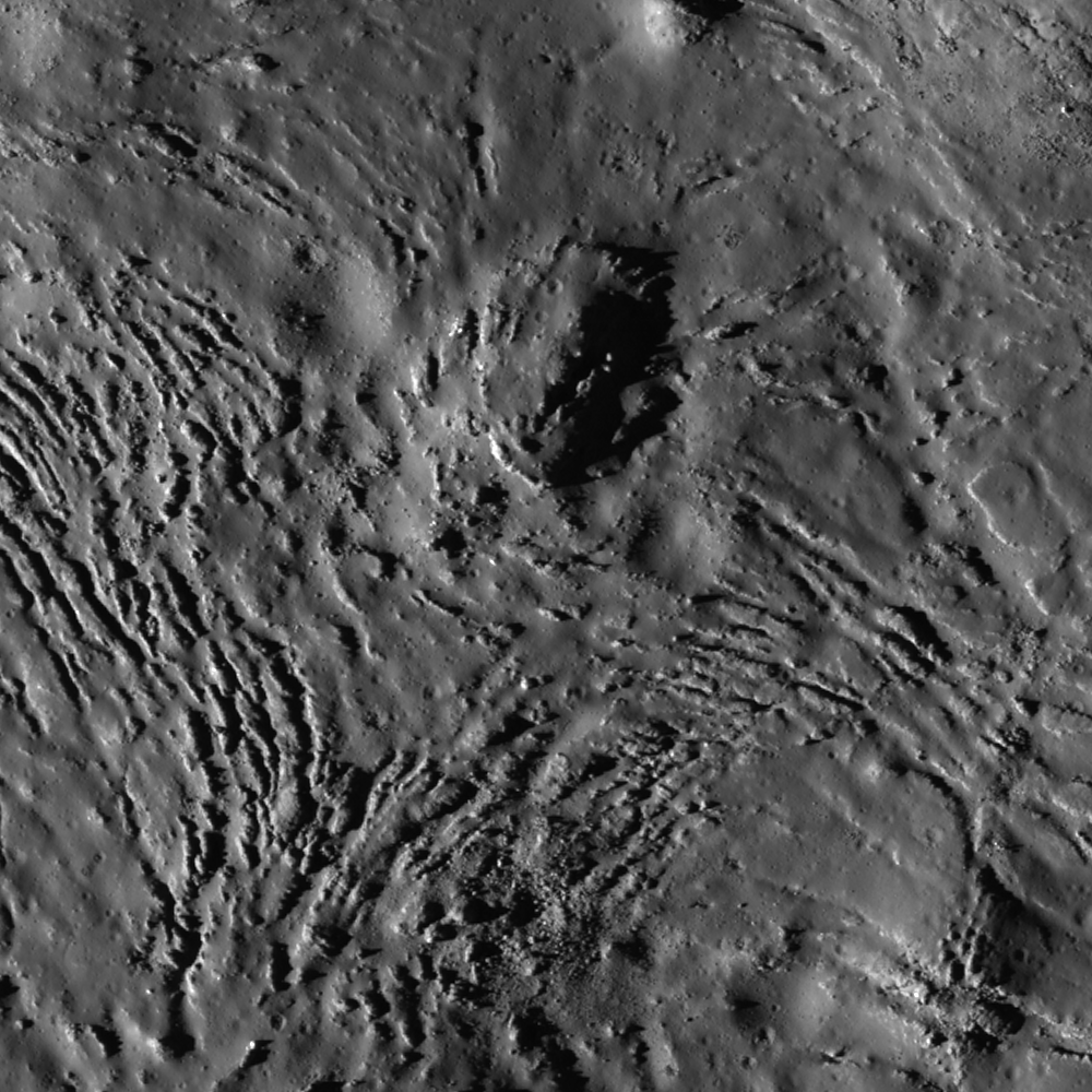
Fractures can be seen in profuse abundance on the Jackson crater melt pond surface. Illumination from west, a field of view roughly 700 meters across swept up at an incidence angle of 71.13° LROC Narrow Angle Camera (NAC) observation M118560367L, LRO orbit 2606, January 19, 2010; resolution 0.84 meters from 52.97 kilometers altitude. View the full-size Featured Image HERE [NASA/GSFC /Arizona State University].
James Ashley
LROC News System

As molten rock cools, it shrinks and often cracks. In this case of impact melt ponded within the Jackson crater floor (22.18°N, 197.24°E), the cracking rate was so high that unfractured melt is almost more of an exception than a rule!

Radial and divergent patterns can be seen among the fracture sets that tell a story of the cooling history. The context image below shows a portion of their wider distribution.

As context for the January 18, 2012 LROC Featured Image (field of view near where the impact melt inundating the crater floor emerges from eastern wall slump; the white box) a long view north and up the steep northeastern wall, nearly to the rim, courtesy of the digital elevation model combined in Google Earth [NASA/USGS/ASU/JAXA/Google].
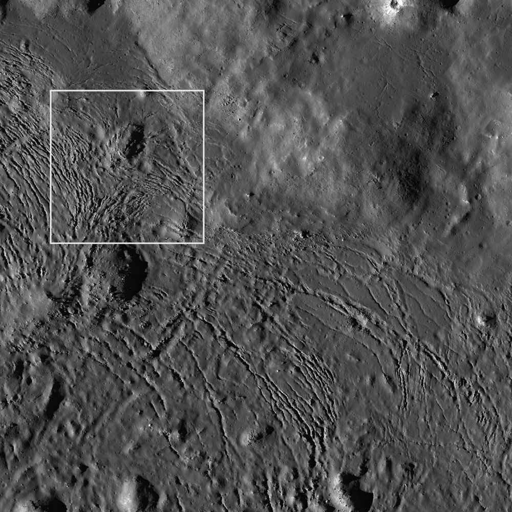
Overhead context for Featured Image, a field of view roughly 2.5 kilometers across from the wider LROC frame.View the full-size LROC context image HERE [NASA/GSFC/Arizona State University].
Solid objects in the melt, together with the 'shore' of the pond, appear to have influenced the way the cracks organized themselves as the melt cooled. Note how the fractures bend around or radiate from some of the positive relief features in the images above. These could be ejecta blocks or portions of the slumped crater walls in the melt that served to locally accelerate cooling. Their influence might thus be to 'seed' the stress field within the shrinking melt volume, helping some of the cracking to grow from these points, and ultimately resulting in the patterns we see today. Sagging along the shore can cause the cracking to parallel the shoreline. Any motion within the volume of melt, possibly influenced by late-stage additions of molten material, may also have contributed to the patterns observed here.

Further context, from 100 kilometers altitude, this square crop from a highly detailed HDTV still frame was captured by Japan's lunar orbiter SELENE-1 (Kaguya) in 2009 [JAXA/NHK/SELENE].
The extent and complexity of the melt pond features can be explored in the full NAC frame HERE. Additional examples of impact melt cracking include Polygonal fractures on Tycho ejecta deposits, fractured impact melt in Thales crater, and Moore F.

Ed Note: In a way opposite and contributing to the low optical visibility of the vast majority of similarly sized craters in the farside Highlands, Jackson is easier for the eye to see than most. Like Tycho on the nearside, there are a lot of craters of similar size and origin everywhere on the Moon. The difference is age. Like Tycho, the ray system of Jackson (and the materials its progenitor impact threw out) shows Jackson's "optical immaturity." To illustrate, below are two representations of the farside quadrant with the highest of the Highlands scoured by the Jackson impact, likely less than a half billion years ago.

Jackson stands out in this global montage of Clementine (1994) Ultra-Violet/Visible (UVVIS) wavelength photography designed to better map the Moon's albedo, more than a decade ago. Similar craters, basins and the Moon's highest elevations are nearly invisible [NASA/USGS/DOD].

A white arrow is needed to designate Jackson out from the pocked highlands and several otherwise invisible basins stand out with exceptional clarity in this view of nearly the same terrain as a representation of differences in elevation from the LROC Global Digital Terrain Model, developed using LROC Wide Angle Camera survey photography [NASA/GSFC/Arizona State University].