Showing posts with label mass wasting. Show all posts

Thursday, July 24, 2014

Banded Slump in Berzelius W

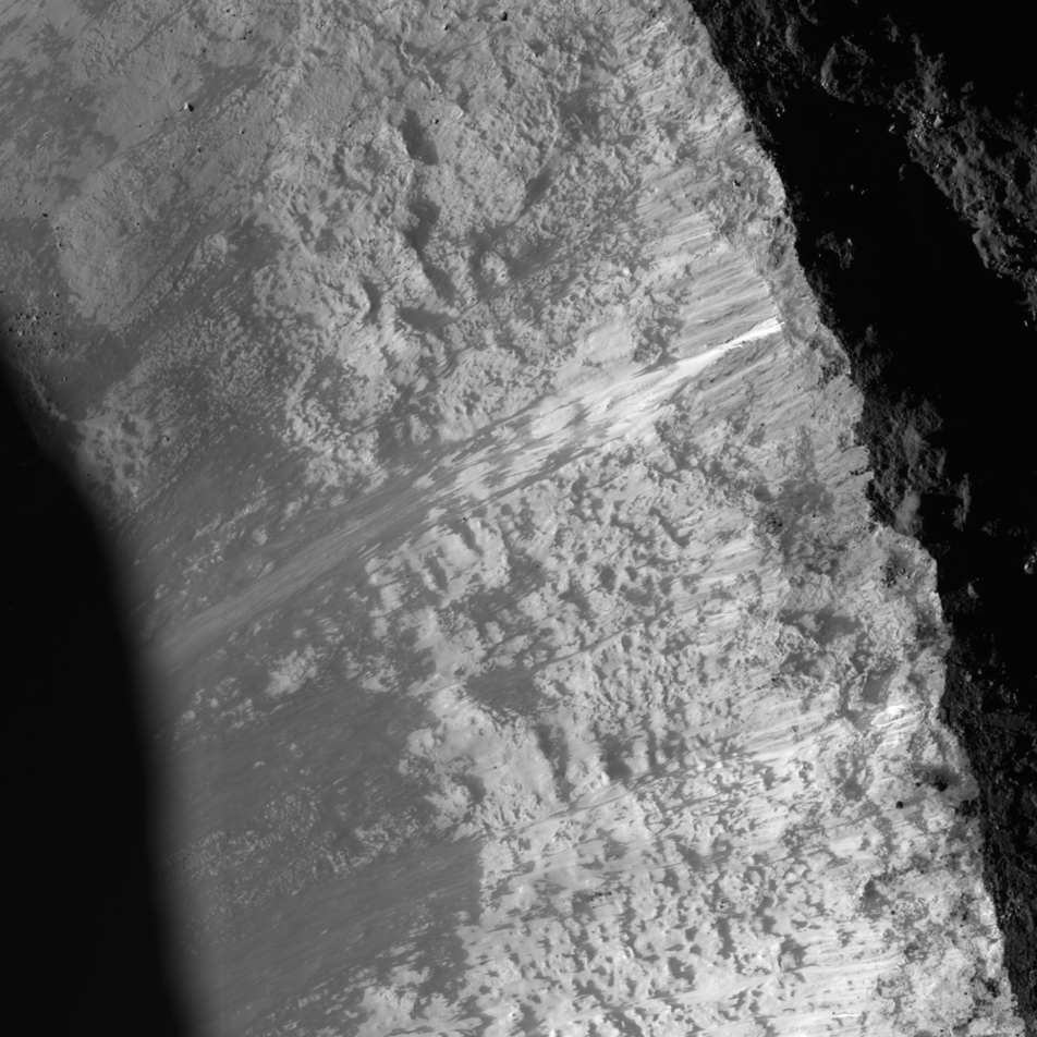
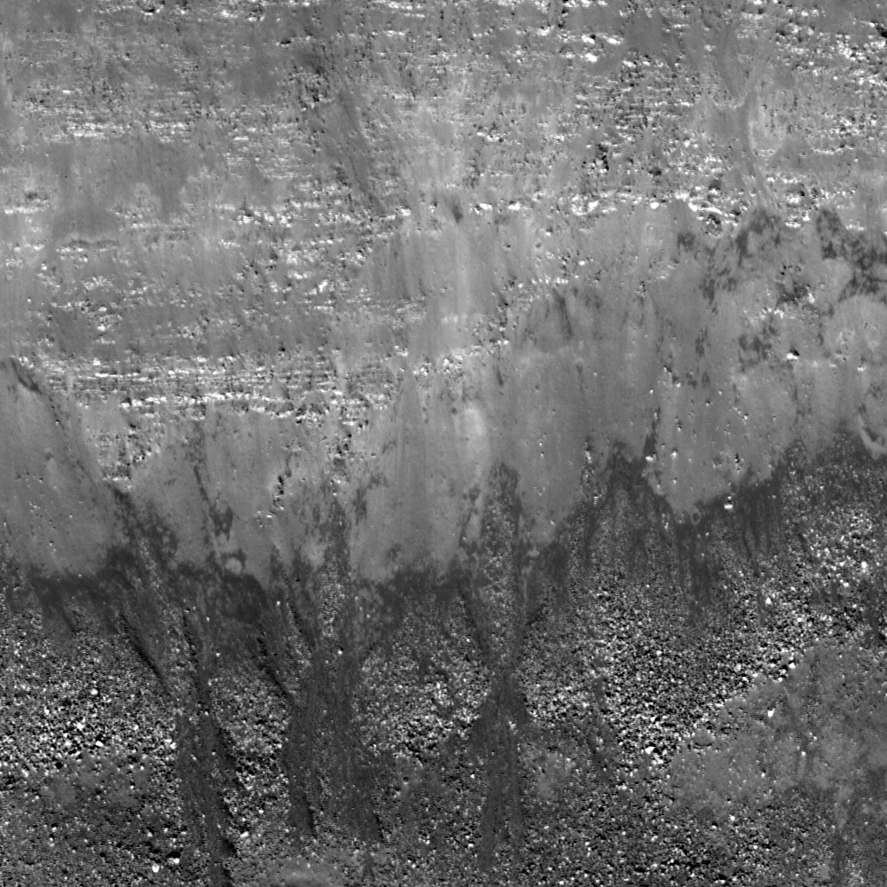
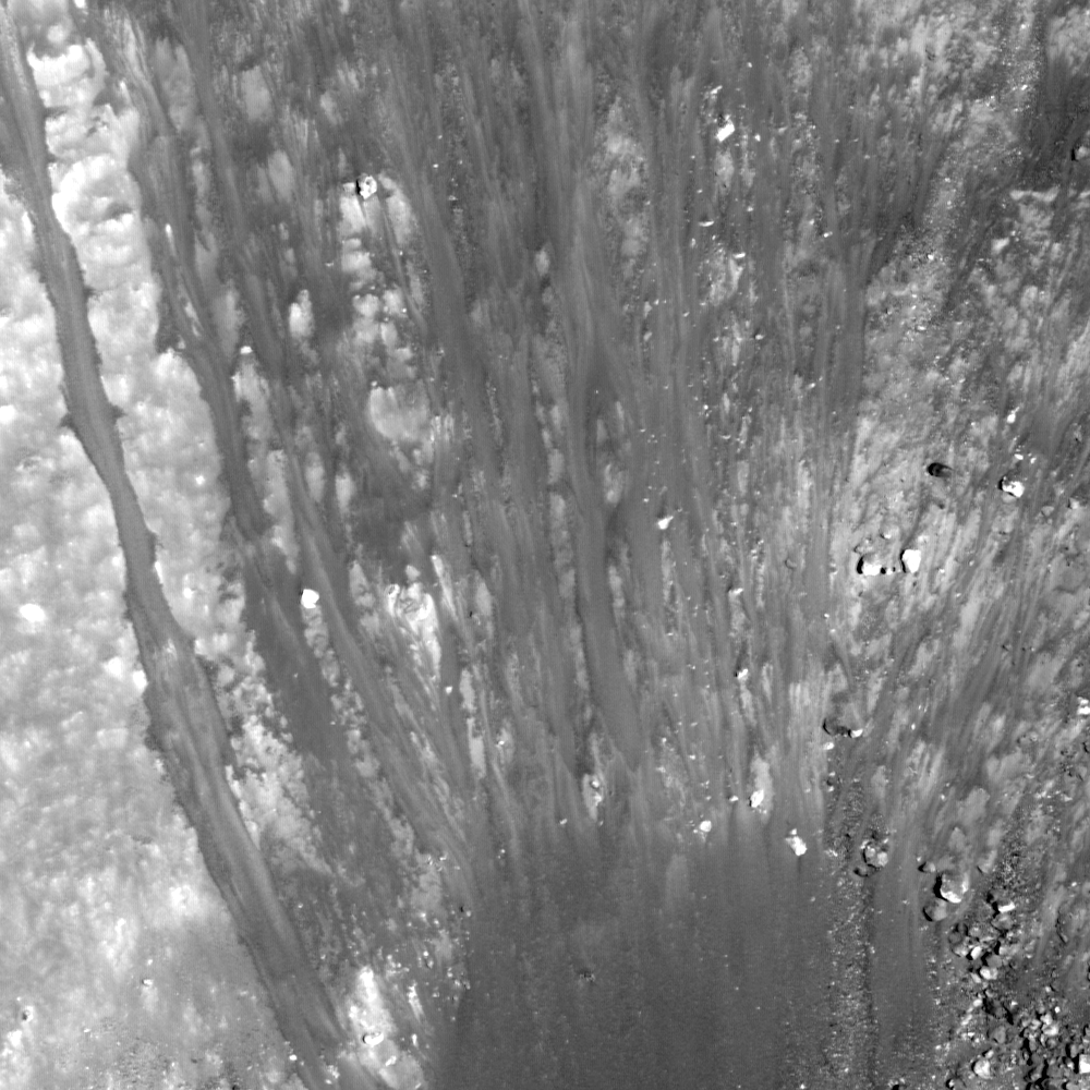
A complex interplay of slumping and slides in the northwest wall of Berzelius W result in banding patterns; downslope is toward the bottom right in this 230 meter-wide field of view from LROC NAC observation M174921824R, LRO orbit 10912, November 3, 2011; 53.59° incidence angle, resolution 40 cm from 23.87 km over 38.06°N, 53.02°E [NASA/GSFC/Arizona State University].
J. Stopar
LROC News System

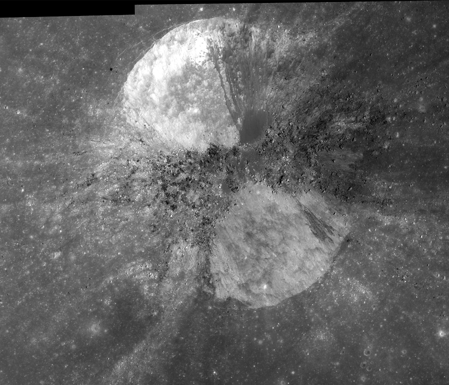
Berzelius W (7.17 km; 38.137°N, 53.103°E), on the northeast limb of the Moon (as seen from the Earth), exhibits abundant evidence for mass wasting.

Materials of varying albedo create intricate patterns on the walls of the crater, including the banding patterns featured in the opening image. 

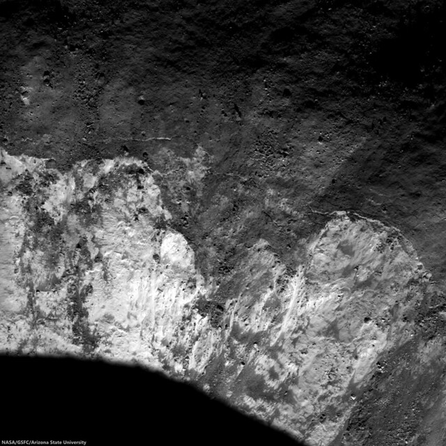
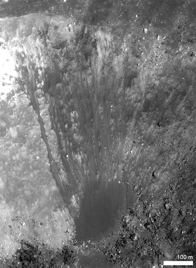
This particular portion of the wall includes a block of slumped material, as indicated by the characteristic arcuate faults near the crater's rim crest (see image below). The slumped material is overprinted by finger-like flows of finer particles that moved as slides of dry debris.

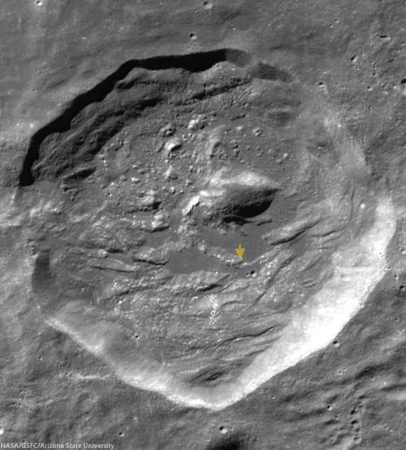
Arrow indicates the arcuate faults at the head of the slumped material in the wall of Berzelius W. This slumping may have triggered the associated narrower and finger-like landslides of lower albedo (darker) boulders and debris; 600 meter field of view [NASA/GSFC/Arizona State University].
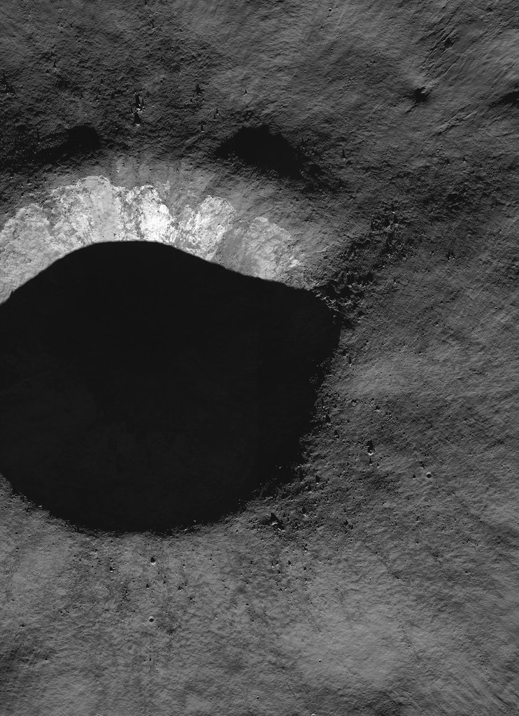
When did these mass-wasting events occur? Did they occur during the impact event, shortly after while the landscape was still ringing from the shock of impact, or millennia later? The lack of high albedo (bright) ejecta around the crater and the subdued appearance of the rim crest indicate that this crater did not form particularly recently; perhaps it is between 1 and 2 billion years old. 

Berzelius W (7.17 km; 38.137°N, 53.103°E) in 35.7 km-wide field of view from LROC WAC monochrome (604 nm) mosaic of M161965061C and M161971828C, LRO orbit 9003 and 9004, June 6, 2011; 73.5° incidence at 61.5 meters resolution from 44.9 km [NASA/GSFC/Arizona State University].
The crisp edges of the debris flows and arcuate scarps in the walls, however, suggest that they are much younger than the crater. So, while this landslide probably did not form yesterday, it is likely significantly younger than the crater itself, probably less than half its age. However, without more data, it is impossible to know precisely when these events occurred. Repeated imaging over many decades may provide more insight into how crater walls age with time. Alternatively, samples returned from crater walls may provide a method to age-date mass-wasting events. 

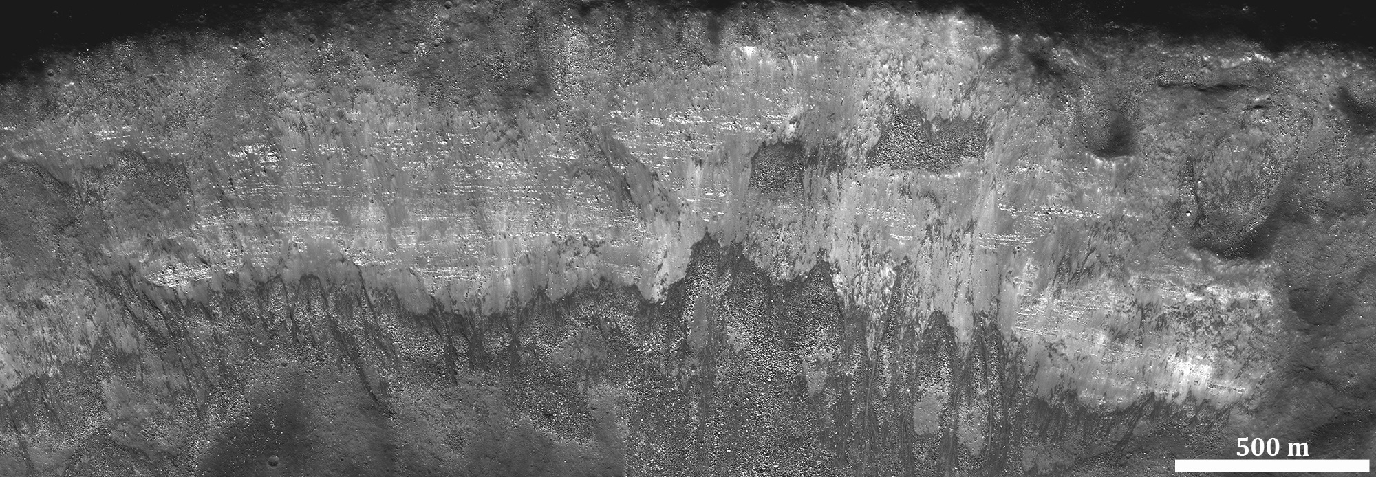
Try to find at least three other examples of mass-wasting features in the western half of this crater below. Pan and zoom to find examples of landslides, talus deposits, and boulder tracks:

Full 850 meter-wide field of view from remarkably high resolution LROC NAC observation M174921824R [NASA/GSFC/Arizona State University].
View full-window HERE.

Related Features:

Tuesday, June 24, 2014

Breaking Down Walls

Gravity is winning as boulders erode and ultimately tumble down from the rim of Moore F (23.8 km; 37.29°N, 185.03°E), in the north farside highlands. 862 meter-wide field of view from LROC NAC mosaic M1156517189LR, LRO orbit 22390, May 18, 2013, spacecraft and camera slew 11.24° from nadir, 84.67° sunset incidence angle, resolution 1.49 meters from 146 km over 37.45°N, 186.59°E [NASA/GSFC/Arizona State University].
H. Meyer
LROC News System

Moore F is located in the highlands of the lunar farside. Its well-defined rim, steep walls, and the predominance of boulders suggest that it is quite young.

Over time, micrometeorite bombardment, the shock from more recent impacts, and other erosional processes break down the rock that composes the crater rim, walls, and floor.

The result will eventually be a smoother, more subdued appearance.  The many large blocks suggest that Moore F has only just begun to break down.

The impact process left Moore F with exquisite impact melt, abundant terracing, and a stunning central uplift, but a closer look reveals subsequent modification courtesy of gravity that has yielded even more entrancing beauty in the flows streaming down its walls, as in the NAC image below. 

LROC NAC image displaying granular flows in the wall of Moore F highlighted by the dramatic lighting of a low sun. Downhill is to the southeast (bottom left). Image width is approximately 8 km [NASA/GSFC/Arizona State University].
The streaks we see on the walls of Moore F in the image above are likely made of granular material that acted like a fluid as it slid downslope. But how do we know if the flows formed by the downslope movement of dry, fine-grained material?

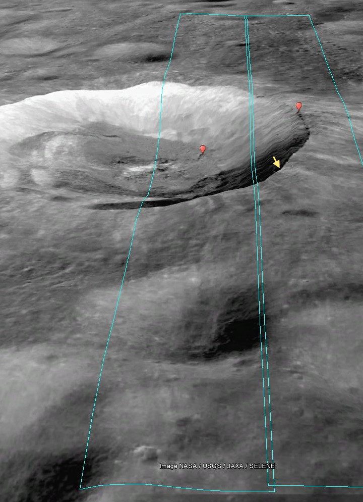
Footprint of LROC NAC observation M1156517189L & R, LRO orbit 22390, May 18, 2013 [PDS/Google Earth].
The sources of the flows can be traced to specific locations and outcrops along the rim of the crater, suggesting that this is material from the rim that was disturbed and flowed downslope. The slightly braided appearance suggests multiple depositional episodes. These episodes could have been triggered by collapsing material from the rim or wall, boulders (like those in the opening image) knocking material loose as they hurtle downhill, or by shockwaves from nearby impacts.

This "real color" false color LROC WAC-derived 155 km field of view, combining Normalized Reflectance with a touch of RGB beta natural coloring, shows the wide dispersal of bright ejecta from Moore F, overwhelming the topography of older, nearby larger craters in the farside highland terrain [NASA/GSFC/Arizona State University].
Investigate this incredible NAC mosaic HERE.

Related Posts:

Wednesday, June 11, 2014

The original interplanetary mountaineers

Traverse plots of Apollo 15 EVA 1 & 2 (August 1 and 2, respectively), the routes astronauts Dave Scott and Jim Irwin drove south to the lower slope of Mons Hadley Delta (from the "Elbow" bend in Rima Hadley, southward, toward the left). Elevations above that of the landing site (LM). For scale, the dogleg distance the astronauts travelled from the LM to Elbow crater along the edge of Hadley Rille over EVA 1 is roughly 4.5 km. Oblique LROC NAC mosaic M1123519889RL, LRO orbit 17751, May 18, 2013; spacecraft and camera slew 55.21° from orbital nadir, 76.87° angle of incidence, resolution 2.87 meters from 130.27 km over 26.11°N, 11.15°E  [NASA/GSFC/Arizona State University].
J. Stopar
LROC News System

The lofty Apennine Mountain Range has two prominent peaks near the Apollo 15 landing site: Mons) Hadley (relative height 4 km) to the northeast and Mons Hadley Delta (3.5 km) toward the south.

Between these two peaks lies the "Swann Range," named for Apollo 15 Geology Team Leader Gordon Swann.

The Apennine Mountain Range contains some of the largest peaks on the Moon Mons Hadley rivals the prominences of notable terrestrial mountains like Mt. Rainier and Mt. Fuji, and Mt. Erebus in Antarctica when measured from base to summit.
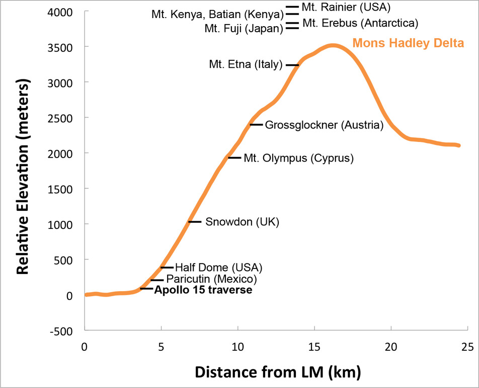
Elevation profile of Mons Hadley Delta, measured from the Apollo 15 landing site (left) through the peak (right); data from the LROC WAC-derived GLD100 Digital Terrain Model (DTM), with relative heights of notable terrestrial mountains shown for scale. Mons Hadley Delta is not the largest peak in the Apennines, and Scott and Irwin scaled only a small portion of the mountain's contact zone with the Hadley Delta plain [NASA/GSFC/Arizona State University].
The first Apollo 15 EVA took astronauts David Scott and James Irving southward along the edge of Hadley Rille and to the base of Mt. Hadley Delta near St. George crater. This traverse took them to a height of just over 65 meters above the landing site on the mare plain. At this height, much of the surface material of the mountain comprises debris that, over eons, slid down the upper slopes through mass-wasting. Materials collected in this area primarily consist of regolith, as there are very few surface boulders.
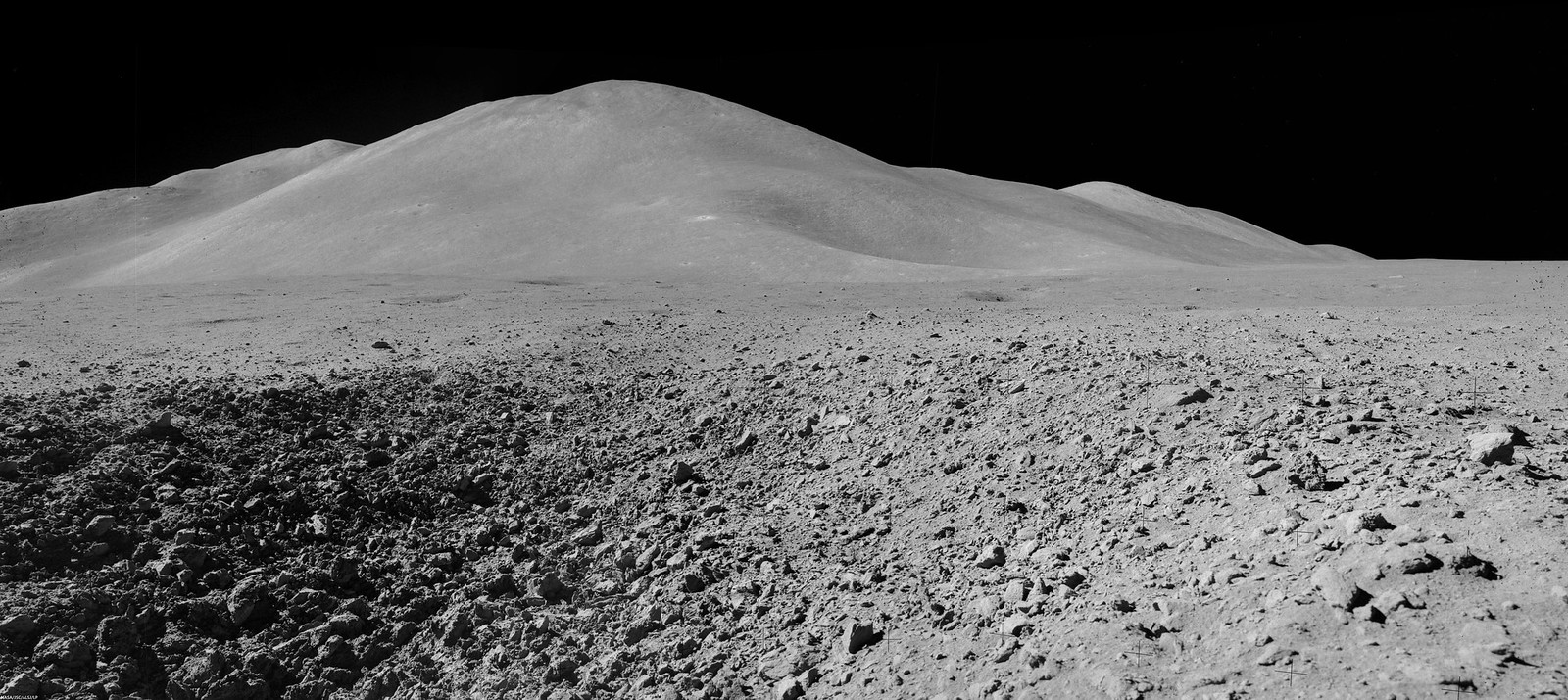
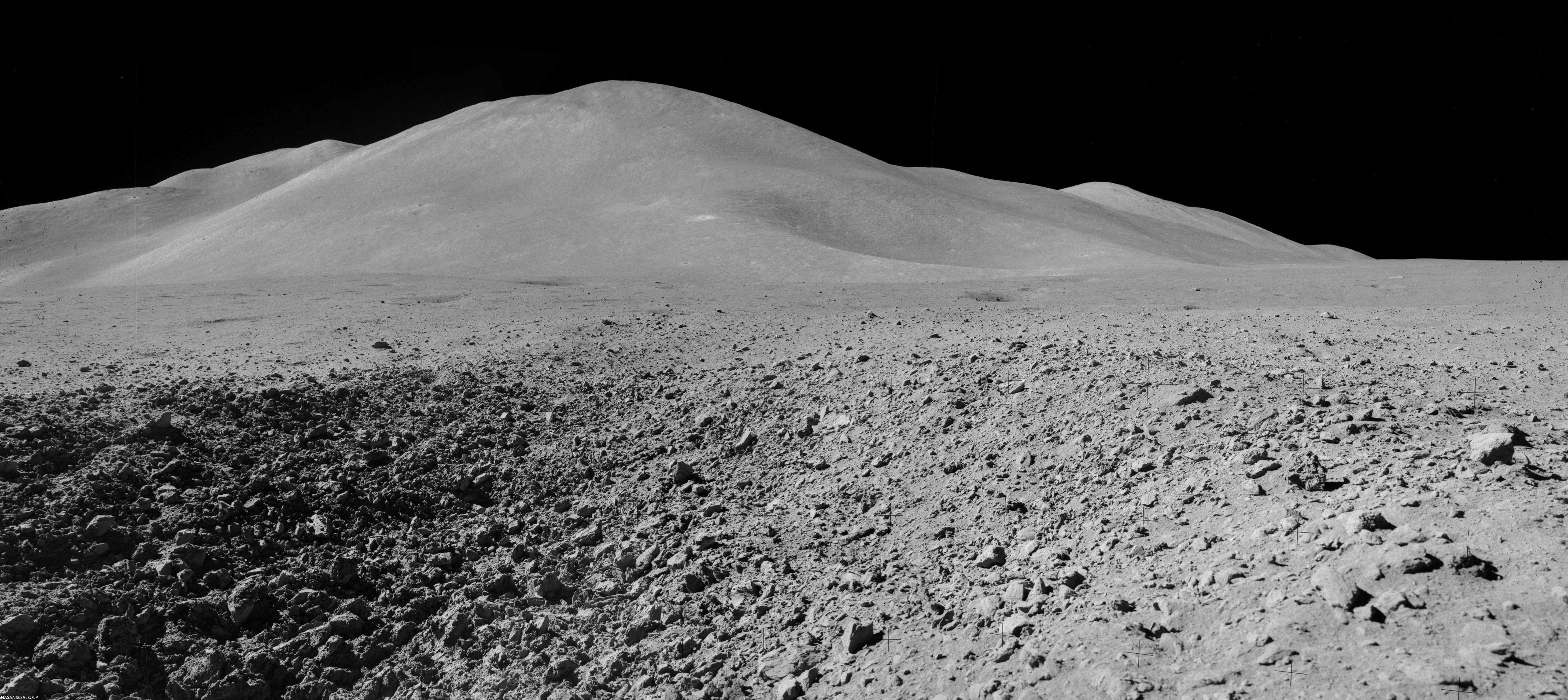
Mons Hadley Delta (high-resolution mosaics HERE); Mosaic of Dave Scott's Station 9 panorama (AS15-82-11084-88), from northeastern wall of the "Station 9 crater," a relatively fresh 15 meter-wide feature characterized by soft clod-like blocks of pressure-pressed regolith formed at small impact. Station 9 crater is about 240 meters immediately northeast of Rima Hadley; Apollo 15 (EVA 3), August 2, 1971 [Dave Scott/NASA/JSC/ALSJ].
The second EVA took the astronauts southeast to "South Cluster" and Spur craters. At Spur crater, a very old crystalline rock fragment was collected, containing evidence of geologic processes more than 4 billion years old and representing a piece of the original anorthositic crust of the Moon. They also discovered an unusual green material composed of volcanic glass.

This traverse ascended about 95 meters in elevation, up the base of Mons Hadley Delta. At times, the slope was steep enough (~ 18°) that the rover had difficulty getting traction, and the mountain peak loomed so high overhead, that the astronauts could not lean back far enough to get it in the frame of their cameras.

Apparent outcrops (arrows) may represent a high-lava mark approximately 85 meter up the south slope of Mons Hadley. AS15 magazine 84. View a more dramatic mosaic from this panorama HERE [NASA/JSC/Apollo 15 Lunar Surface Journal/Arizona State University].
During this traverse, the astronauts commented that they thought they could detect a high-mark where lava might once have filled the basin at the base of nearby Mt. Hadley around a height of 85 meters above the current mare plain.
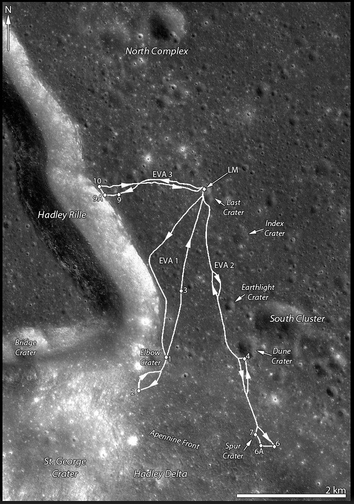
LROC projection with traverse courses of Apollo 15 expedition to Hadley Delta, July 30-August 2, 1971 [NASA/GSFC/Arizona State University].
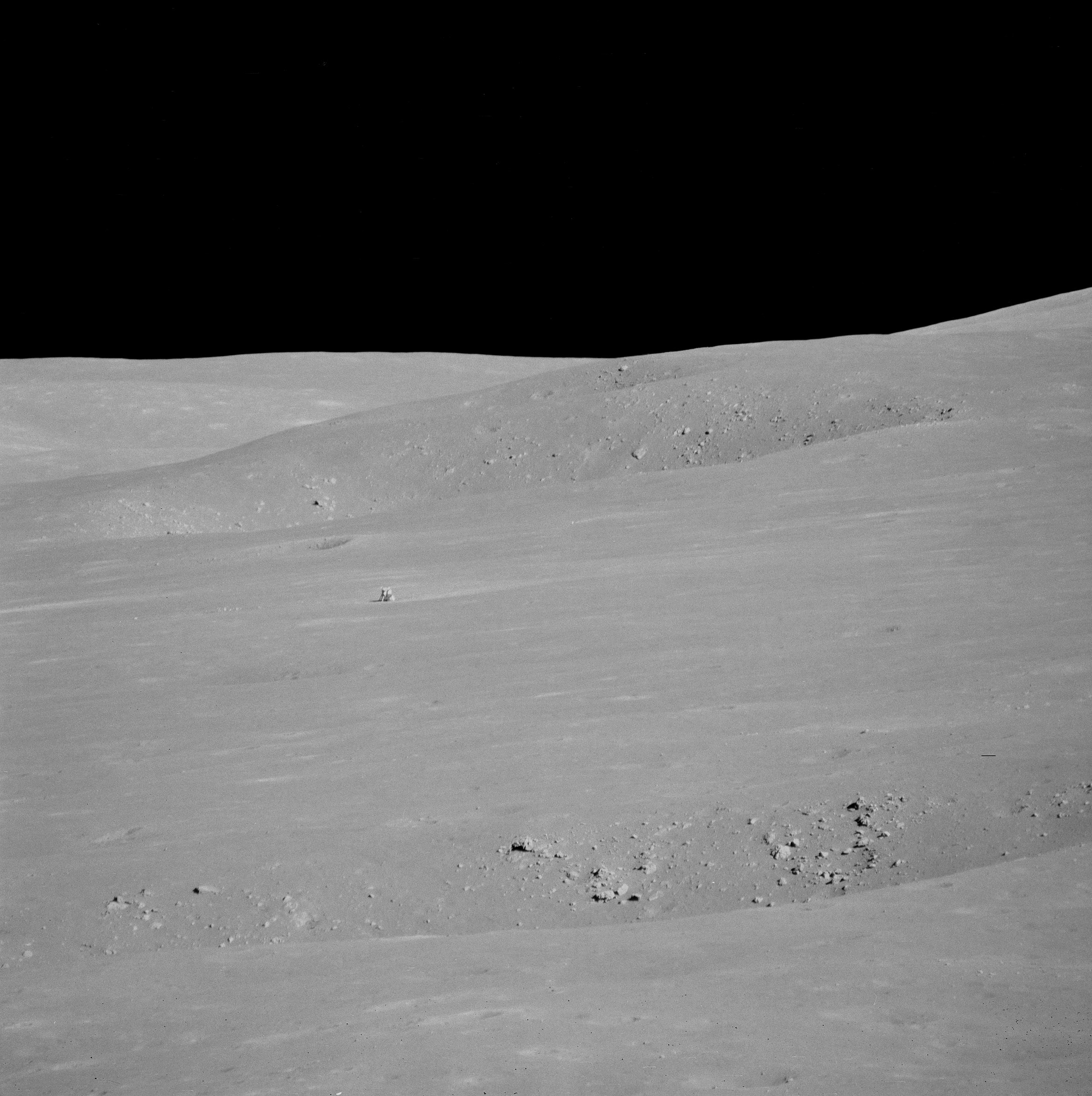
From Science Station 6. It definitely worthwhile to see a larger, high-resolution mosaic of this, reported to be Dave Scott's favorite photograph from the expedition (HERE). Through a 500-mm lens, from Science Station 6 up on the Apennine Front, the lunar module Falcon and ALSEP components are seen from 4.7 km, backdropped by the North Complex crater group and flank of Mons Hadley, on the plain's opposite bank [NASA/JSC].
Apollo 15, Science Station 6, Spur Crater, on the Apennine Front, August 1, 1971. Dave Scott employs his 500 mm lens and black and white magazine 84 to capture the image immediately above, the Apollo 15 lunar module Falcon and North Complex crater group in context of the high mountains surrounding the Hadley Delta landing site. Still clipped from live video transmission relayed from remote-operated color TV camera on the lunar rover [NASA/JSC/ALSJ].
After capturing his black and white 500 mm panorama, Cmdr. Scott returned employed color magazine 86 and a less awkward smaller focal length. The reproduction here is too small to see the lunar module, but a much cleaner full resolution version is available HERE. Though it is not as detailed, and coherent backscatter is more problematic than the black and white at 500 mm, the full-resolution color image more closely matches the unaided human eye.  AS15-86-11618 [NASA/JSC/ALSJ].
While the Apollo 15 astronauts scarcely climbed the lower slopes of a lunar mountain, they made many important discoveries. What challenges, findings, and fun (like slope skiing) might future explorers experience on the powdery mountains of the Moon?

Explore the first two of the Apollo 15 traverses in more detail below by panning and zooming. The numbers indicate relative elevations of the paths travelled by the astronauts.

Related Posts:
Soaring Over Mighty Mt. Hadley
Apollo 15 departs Hadley Rille Delta
Water found in the Apollo 15 Genesis Rock
Follow the Tracks (Apollo 15)
Hadley Rille and the Mountains of the Moon
Retracing the Steps of Apollo 15 Constellation Region of Interest
Apollo 15 Laser Ranging Retroreflector: a Fundamental Point on the Moon
LROC's First Look at the Apollo Landing Sites
'Man's first wheels on the Moon' at 41 years
Bowditch Lava Terraces
Lunar Kipuka
Remnants of the Imbrium Impact
Hadley-Apennine: the Apollo 15 Landing Site
The Mighty Apennine Mountain Range
Layers near Apollo 15 Landing Site
LROC Explores Apollo 15 (YouTube video)
Kaguya captures Rima Hadley

Thursday, June 5, 2014

Rima Seuss, rough around the edges

With peppered flanks, Rima Suess wanders over 150 km through Oceanus Procellarum. The rocks that rest on the walls of this sinuous rille are perhaps remnants of much larger boulders that have eroded down to meter sized rocks due to relentless micro and macro meteorite bombardment, "gardening" 3 centimeters into lunar dust every 2 million years or so. The pyroclastic flow that carved through the terrain was remarkably fast, considering the long scar left behind has lasted perhaps 3 billion years. From the extraordinary low altitude of only 23 km (see below), the 400 meter field of view above is cropped from LROC NAC observation M168516400R  [NASA/GSFC/Arizona State University].
Raquel Nuno
LROC News System

Rima Suess (7.81°N, 312.41°E), located in Oceanus Procellarum, is a long, meandering narrow depression called a sinuous rille.

Sinuous rilles, most commonly found in mare surfaces, are thought to have been carved by fast rivers of lava, which thermally and mechanically eroded the channels we see today.

About 3.1 billion years ago the Moon was much more volcanically active, pouring vast amounts of lava onto the surface. The large dark mare regions of the Moon were formed by massive eruptions of iron-rich basaltic lava during this time.

Very close-up on Rima Suess, the LROC NAC observation from which this and the LROC Featured Image were processed was from among one of the closest passes of the Lunar Reconnaissance Orbiter (LRO) over the Moon, during low-periapsis maneuvers in 2011. (Full resolution original image HERE.)  LROC NAC observation M168516400R, LRO orbit 9968, August 12, 2011; 36.11° incidence angle, resolution 39 cm from 22.92 km over 8.07°N, 312.38° [NASA/GSFC/Arizona State University].
The boulders along the walls of the rille probably were a coherent mass when the lava flows cooled, breaking up over billions of years of impacts into the boulders we see today. Gravity then pulled this material down the slope of the rille; this process is known as mass wasting. We see rock outcrops over the entire path of Rima Suess in the LROC NAC image M168516400R.

The very narrow, actually a 200 km-plus-long sinuous rille, apparently traced remarkably fast south from the Marius Hills "Yulu" double-volcano source nearly to Flamsteed P crater, through the bleak center of Oceanus Procellarum. Nearby Kepler crater (outside this view, to the right and east) added the bright ejecta rays. This view is distilled from a mosaic of LROC Wide Angle Camera (WAC) observations swept up over five sequential orbits during local early local morning, allowing long shadows to add some relief to this remarkably flat area of the lunar surface, all of it averaging below 2000 meters in elevation. LROC WAC mosaic from LRO orbits 6838 through 6842, December 18, 2010; 79° incidence angle, resolution 58 meters from 41.5 km [NASA/GSFC/Arizona State University].
Lunar rilles are exciting places for lunar scientists because they may cut through and expose the different layers of lava flows in the maria.  This gives scientists insight into the volcanic processes present during mare formation, and how they evolved with time.

Explore the winding path of this portion of Rima Seuss in the full resolution LROC NAC HERE.

Related Posts:
Rilles as far as the eye can see in Prinz!
Rille within a rille!
Collapsing Tube

Thursday, May 1, 2014

Elongated crater in west Tranquillitatis

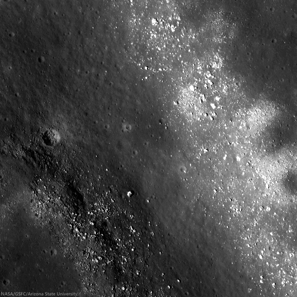
Wall and Rim of Arago E: Full resolution sample from and unusually low-altitude, LROC Narrow Angle Camera (NAC) observation from only 40 km altitude. The sample above shows detail of the northeast wall and floor of Arago E, an excavation of the complex Arago area of western Mare Tranquillitatis. The floor is peppered with boulders that have tumbled down the crater wall. This roughly 800 meter sq. field of view was cropped from LROC NAC M155084711R, LRO orbit 7989, March 18, 2011; resolution 47 cm per pixel, angle of incidence 10° from 40.02 km [NASA/GSFC/Arizona State University].
Raquel Nuno
LROC News System

Arago E (8.5°N ,22.71E°) is an elongated crater located in Mare Tranquillitatis, north of the July 1969 landing site of Apollo 11.

An unusually shaped crater, Arago E is nestled between two wrinkle ridges (see Wide Angle Camera context image below), tectonic features formed by the deformation of the basaltic rocks that make up the lunar maria.

Massive maria lavas placed an extra load on the surface, and these deformations are adjustments of the surface due to the unrelenting force of gravity buckling the rock.

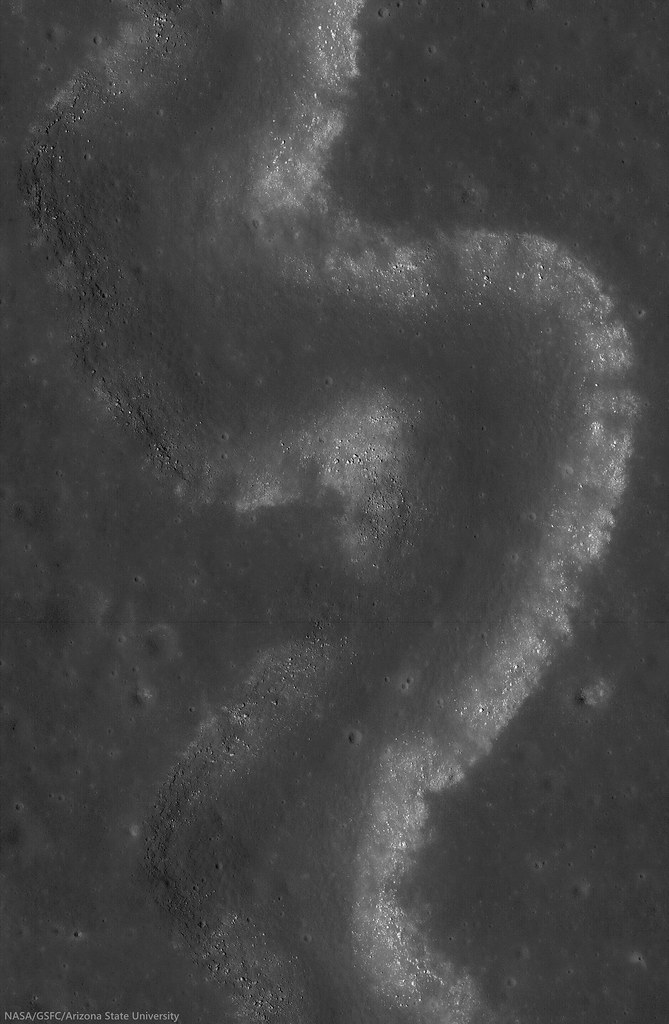
Mosaic from the left and right LROC NAC cameras, LROC NAC observation M155084711R and L, allowing a wider look at the 3.7 km c 6.7 km interior of Arago E. View the original (1000 x 1710) reproduction HERE [NASA/GSFC/Arizona State University].
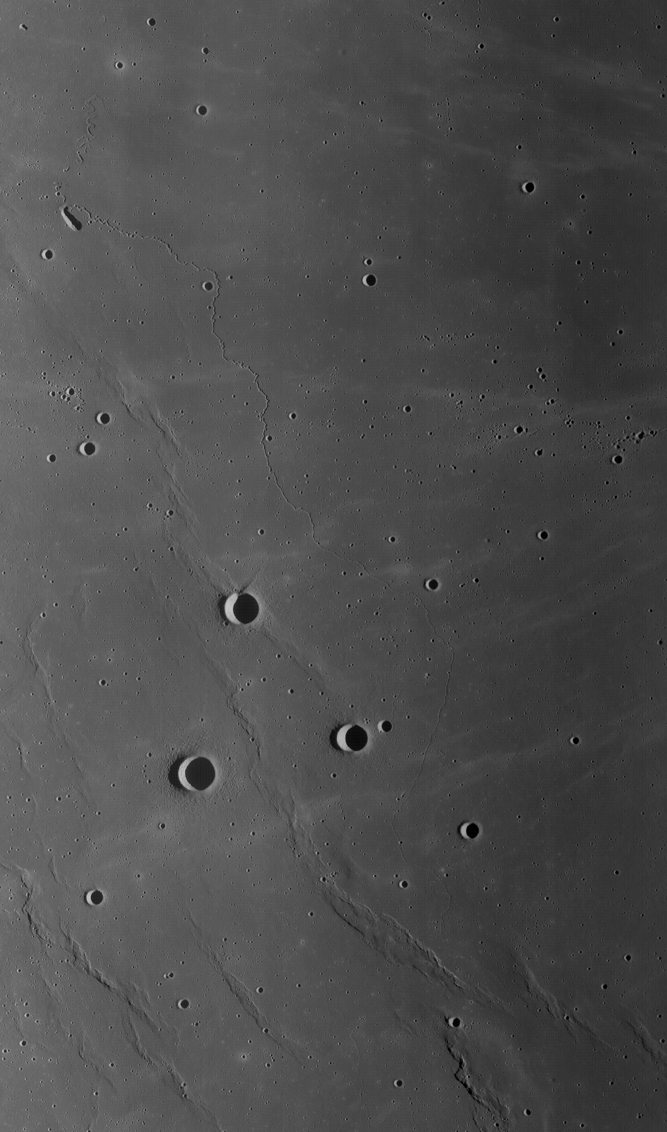
Elongated Arago E and the ruffled surface of west Tranquillitatis: High angle, early morning illumination highlights the undulations of the Tranquillitatis terrain between 25.5 km Arago, at lower left (6.15°N, 21.43°E) and the elongated, still partially shadowed interior of Arago E at upper center in this roughly 75 km-wide field of view from a mosaic made from two sequential LROC Wide Angle Camera passes, in orbits 6772 and 6773, December 13, 2010. 60 meters per pixel resolution, angle of incidence 74° from 44 km. View the original reproduction (1223 x 1951) HERE [NASA/GSFC/Arizona State University].
This crater's elongated shape is perhaps due to an oblique impact, which impart excess horizontal momentum into the surface leaving an elongated shape. However, for this to happen it's thought a progenitor projectile had to have been arriving from less than 30° above the horizon.

Volcanic vents can also display elongated shapes but don't exhibit raised rims and usually lack a flat floor from pooled impact melt, and both features are seen in Arago E.

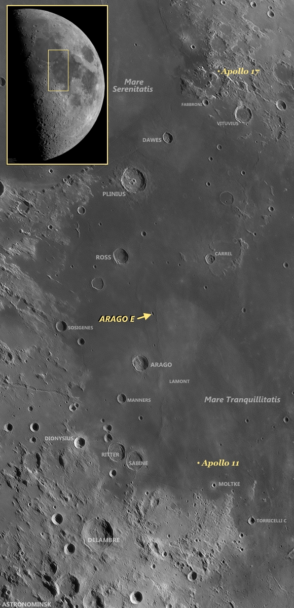
Earthview context for Arago E: Arago and Arago E are familiar landmarks in telescopic views from Earth. With only a little practice, even amateurs, using modest telescopes can pick them out and, in their mind's eye at least, also pick out the relatively nearby landing sites of Apollo 11 and Apollo 17, the first and the last Apollo surface expeditions. The full-scale mosaic (inset) was "stacked" from ten frames April 21, 2010 by Yuri Goryachko, Mikhail Abgarian & Konstantin Morozov of Belarus [Astronominsk].
A picture of this crater was taken from orbit during the Apollo 15 mission. (You can see it HERE.) How does the LROC NAC observation, at full resolution HERE, compare?
Related Posts:
A Stark Beauty All Its Own
Constellation Region of Interest at Mare Tranquillitatis
Wrinkle Ridges in Aitken Crater
Wrinkle Ridge vs. Impact Crater
Not Your Average Crater

Tuesday, April 8, 2014

Swept Slopes of Herigonius

Banded layers of mare basalts uncovered by mass wasting in the eastern wall of Herigonius crater. The rim crest is outside the top of the image field of view (north is to the left). Debris and boulders accumulate downslope, below, toward the crater floor and center. 500 meter field of view from LROC NAC observation M150741485; LRO orbit 7348, January 27, 2011; incidence angle 60° at a half meter resolution from 46.46 km [NASA/GSFC/Arizona State University].
J. Stopar
LROC News System

Gravity, as well as seismic events, keep the upper slopes of the east of wall of Herigonius crater (14.86 km; 13.321°S, 326.029°E) swept clean by moving material downslope.

Herigonius is a large crater at the southernmost extent of Oceanus Procellarum.

Mass wasting reveals banded layers of mare basalt. Individual layers can be traced north to south across much of the wall of Herigonius, and as a whole, represent multiple broad, thin lava flows (see image of the east wall below).

East wall of Herigonius crater, rim crest at top of image, floor toward the bottom. Click on image to see how the layers of basalt are exposed in this part of the upper wall [NASA/GSFC/Arizona State University].
Blocky overhangs indicate areas more resistant to mass wasting and are comprised of the more coherent parts of the lava flows. However, layers of mare basalt are not exposed in all of the walls of Herigonius crater and are best observed in the eastern portion. The entire region is dominated by mare lava flows, but why are the layers so prominent in the eastern wall?

Elevation data derived from the LROC WAC instrument (GLD100) allows investigation of the topography and slopes of the Herigonius crater. The slope map (below), which is a measure of the average change in topography from pixel to pixel, shows that the eastern wall of Herigonius crater is one of the steepest parts of the crater. This steepness may help to continuously expose fresh new materials and basalt layers. Alternatively, the coherent layers of the prominent mare flows in this region are more resistant to downslope movements and can support steeper slopes that are, in turn, more resistant to the build up of debris.

Slope map (overlain on shaded-relief) of Herigonius crater, generated from the LROC WAC GLD100 product. Steeper slopes shown in red, lower angle slopes are purple and blue. Red areas, including the east wall, have slopes around 40° and correspond to outcrops of banded mare layers [NASA/GSFC/Arizona State University].
Explore the east wall in full resolution, HERE, and the entire crater, HERE.

Related Posts:
Layering in Messier A
Marius A
Dawes
Outcrops in Laplace A
Apollo Basin Mare in a Sea of Highlands

Tuesday, March 25, 2014

Young Crater Walls (at the Schrödinger Antipode)

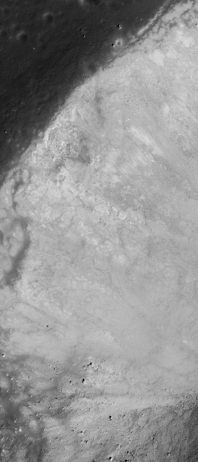
Northern rim of an unnamed young crater near 80°N, 278.9°E, north of Catena Sylvester, on the far north nearside and nested within crustal magnetism that may be related to the Moon's youngest impact basin (Schrödinger) on the direct opposite side of the Moon. 1243 meter-wide field of view, sampled from LROC Narrow Angle Camera observation M125130801R, LRO orbit 3574, April 5, 2010; 78.42° incidence, 1.09 meters resolution from 53 km [NASA/GSFC/Arizona State University].].
Hiroyuki Sato
LROC News System

After the unimaginably violent processes of excavation and ejecta emplacement, impact craters gradually change their shapes with time by various processes, such as the isostatic rebound, mass wasting, subsequent impacts, and space weathering.

Today's Featured Image highlights such a post-impact degradation process.

Full-width mosaic of the LROC NAC observation from orbit 3574. The full-sized (4581 x 6319) original can be viewed HERE. Though the high-angle of illumination at this high latitude favors outlines of topography over intrinsic brightness and color,  relatively darker and lighter materials radiate over great distances, aiding studies of how younger materials interact with anomalous local magnetism [NASA/GSFC/Arizona State University].
The lower half of this image (relatively high reflectance) is the crater wall, downslope is to the bottom. The bottom-left dark area is the shadow of southern crater rim. Upper half of the image with a low reflectance surface is the crater rim and the rim slope out of the cavity, mostly covered with impact melt. The low reflectance area at the image center just above the steep wall has multiple horizontal cracks showing where the hardened impact melt has cracked as the steep walls slowly fail and slide into the crater bit-by-bit. These slope failures continuously refresh the crater walls, removing the melt coatings and exposing subsurface materials.

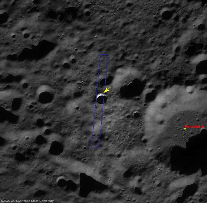
Context image of the unnamed crater and the surrounding area in LROC WAC monochrome mosaic (100 m/pix). Image center is 79.97°N, 278.87°E; image width is about 66 km. The NAC footprint and the location of the opening image are illustrated [NASA/GSFC/Arizona State University].
Most of the fresh craters that we observe have suffered these slides, leaving the commonly observed rootless melt flow features on the rim slopes. Just after the impact occurred, much of the crater interior was covered by impact melt, but these rock veneers are quickly removed from steep slopes leaving fresh outcrops of the target (regolith and, in the case of mare, bedrock).

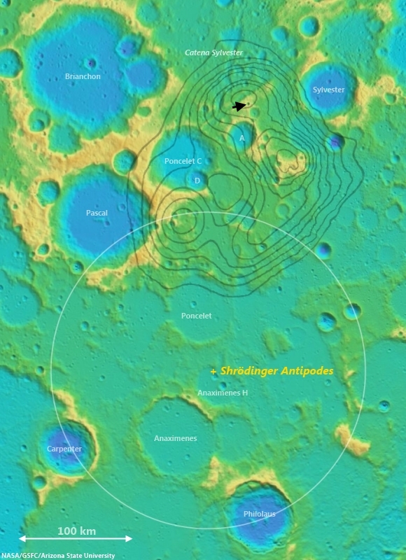
Arrow marks the young crater highlighted in the LROC Featured Image, released March 25, 2014, west of Poncelet C. The white circle is an approximate reflection of the parameters of the Schrödinger impact basin, the Moon's youngest, centered on a point on the diametrically opposite (antipodal) side of the Moon from the center of Schrödinger, in the far south. Grey lines outline nodes of anomalous crustal magnetism teased from Lunar Prospector (1998-99) data. Noted planetary scientists Lon Hood and Paul Spudis use the excavation caused by the smaller impact to aid in determining how local topography may have been disrupted, as they have suggested, by the force of the Schrödinger basin-forming impact. One challenge will be to determine how much the comparatively weak crustal magnetism interacts with migrating dust and fresh impact debris to create albedo swirl features [NASA/GSFC/Arizona State University]. 
Explore the resurfaced fresh crater walls in full NAC frame yourself, HERE.

Related Posts:
The Moon's antipodal magnetism mystery
Lunar swirl phenomena from LRO
Slope failure near Aratus crater
Sinuous Cracks
Slope Resurfacing
Stratified Ejecta Blocks
Dark Impact Melt Sheet
Thin Dark Layer

Tuesday, January 28, 2014

Boulders on a hill on the floor of Rutherfurd crater

Boulders on the floor of Rutherford (LROC NAC)
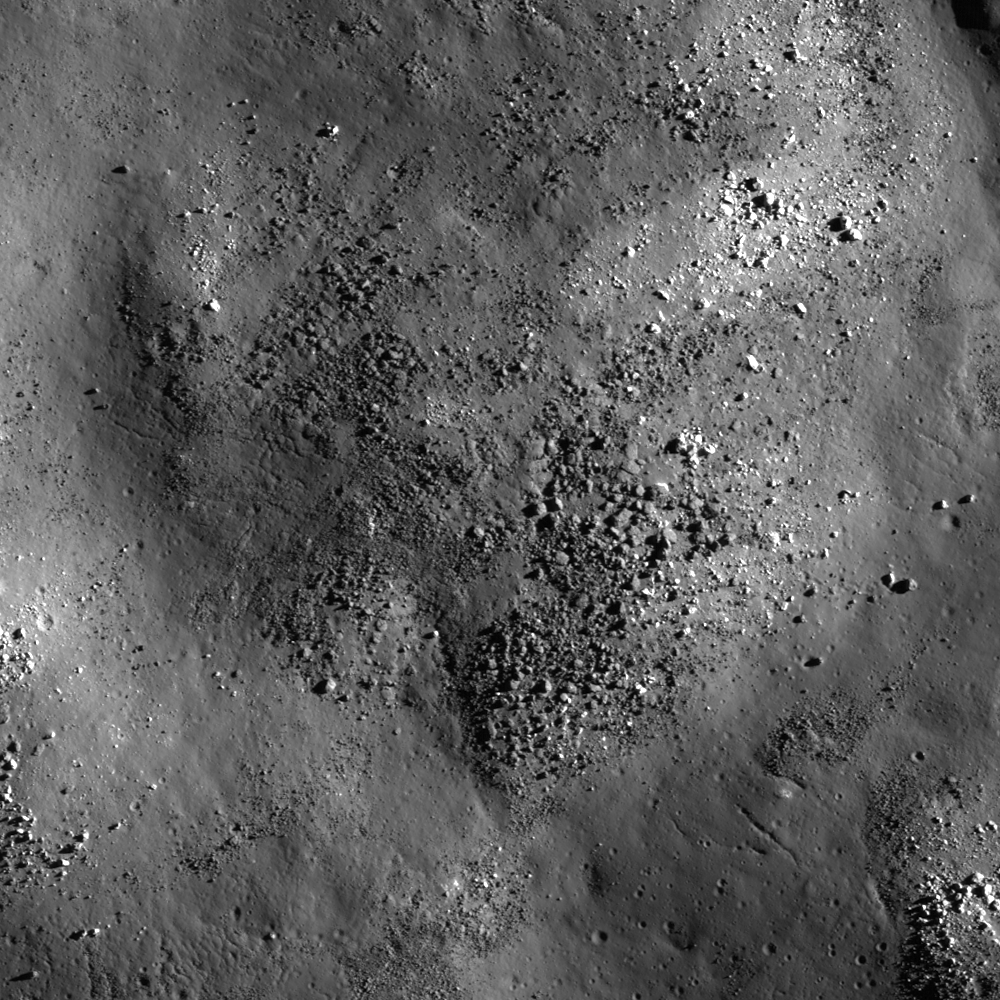
Knobby surface of Rutherfurd crater floor, 1050 meter-wide LROC NAC field of view centered on 61.340°S, 348.085°E,  NAC M1123653329R, spacecraft orbit 17669, May 20, 2013; incidence angle 81° from 50.83 km  [NASA/GSFC/Arizona State University].
Hiroyuki Sato
LROC News System

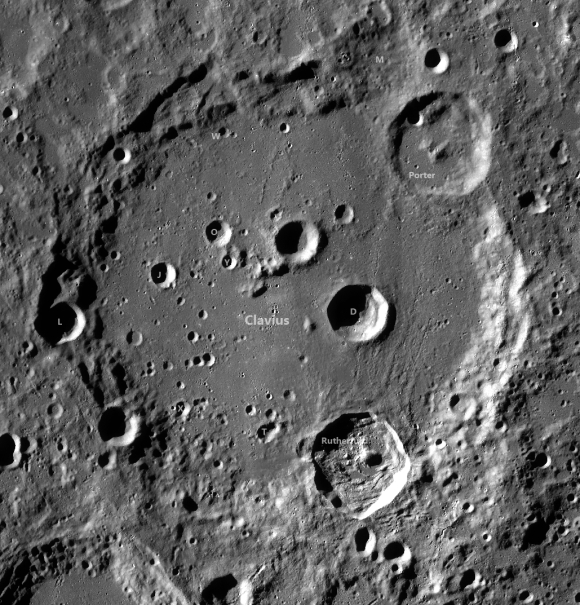
Today's Featured Image highlights a bumpy hill adjacent to a large melt pool (now frozen to solid rock) inside Rutherfurd crater (48 km in diameter). As seen in the WAC context image below, the floor is mostly littered with materials that collapsed and slumped from the crater wall, and with impact melts filling the topographic lows.

Uphill is to the left of the image, here you can see a wrinkled/fractured surface, likely formed as a thin rigid sheet of frozen melt. Over time this melt rock slowly broke apart -- the source of other boulders. The boulders slowly migrate downhill, breaking themselves apart, a form of mass wasting similar to that seen on Earth. However there is a big difference, almost all the energy on the Moon is provided by a continual rain of small meteorites, whereas on the Earth erosion is driven by plate motion induced earthquakes, and weathering.

Rutherfurd crater (LROC WAC)
49.98 km Rutherfurd crater (61.15°S, 346.278°E), nested on the rim of more famed, much wider and older Clavius, in the nearside southern highlands. The area captured at high-resolution and released as the LROC Featured Image, January 28, 2014, is marked with an arrow. LROC WAC global mosaic [NASA/GSFC/Arizona State University].

Rutherfurd from Earth (Damian Peach)
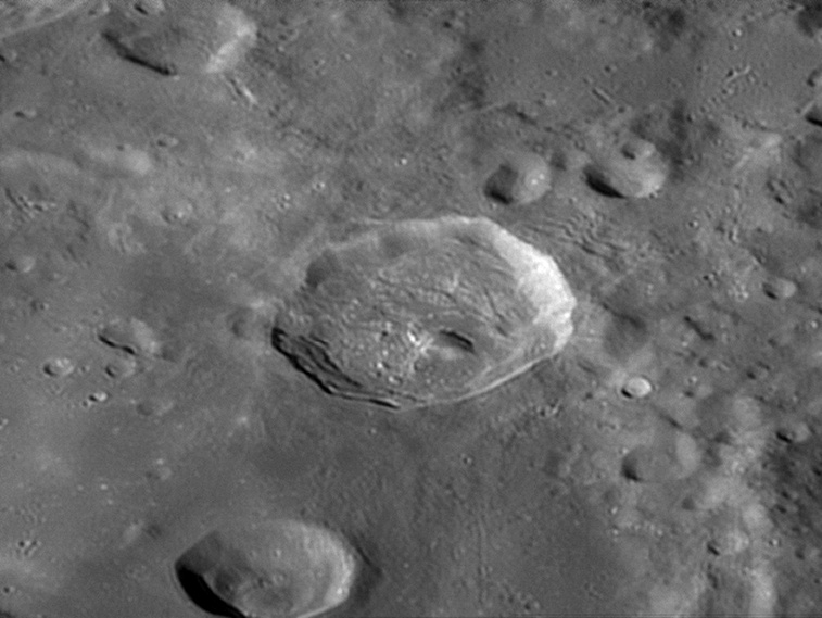
Rutherfurd as viewed from Earth by experienced astrophotographer Damian Peach, November 20, 2005. "Rutherfurd is located entirely within the southern rim of much larger Clavius," he writes. "Rutherfurd is somewhat oval in shape, with the long axis oriented approximately in a north-south direction. The rim is overlaying the inner wall of Clavius, and thus the rim of Rutherfurd is higher above the surface along the north and west sides. The floor is irregular in shape, and there is a central peak somewhat offset to the northeast. The ejecta pattern; oblong shape, and location of the central peak indicate the original impact may have been at a low angle from the southeast [Damian Peach].
Rutherfurd on the rim of Clavius (LROC WAC)
49.98 km Rutherfurd (61.15°S, 346.278°E), nested on the southeastern rim of more famed, much wider and older Clavius, in the nearside Southern Highlands. The area captured at high-resolution and released as the LROC Featured Image, January 28, 2014, is marked with an arrow. LROC WAC global mosaic [NASA/GSFC/Arizona State University].
Explore the floor of Rutherfurd crater in the full NAC frame with very low sun, HERE.

Related Posts:
Central Peak of Rutherfurd
Rough Crater Wall Surface
Sinuous Cracks
View From The Other Side
Cracked mound
A beautiful bench crater (Rutherfurd)

Tuesday, January 14, 2014

Tangle of talus at Schubert A

M141743432_thumb-1000
Multiple dry debris flows along the wall of Schubert A crater. LROC Narrow Angle Camera (NAC) observation M141743432L, spacecraft orbit 6022, October 15, 2010, slew 2° under 15.2° solar incidence, resolution 48 cm per pixel from 41.92 km over 1.49°S, 94.2°E, image field of view 420 meters [NASA/GSFC/Arizona State University].
J. Stopar
LROC News System

A 2.2-km diameter crater, Schubert A (2.135°N, 79.341°E), has steep walls, up to ~30° in slope. These steep walls are susceptible to gravity-driven mass wasting events.

Mass wasting is a geologic process that acts on all planetary surfaces to erode or degrade landforms over time, and results from the downslope movement of rocks and soil under the influence of gravity.

On the Moon, the slope of a surface is a key influencing factor: the steeper the slope, the faster mass wasting occurs. Mass wasting is typically triggered by nearby moonquakes, some caused by impact events.

Schubert_A-context-20140114-900x771
Subsampled NAC mosaic showing Schubert A in entirety, LROC NAC mosaic M141743432LR crater is 1.88 km in diameter [NASA/GSFC/Arizona State University].
Mass wasting on the Moon can take many forms from rockfalls, the plummeting of a few boulders, to rock avalanches and landslides. Material moving downslope in a fluid-like manner is often called a debris flow. And even though water is not required to cause debris flows, the resulting landforms resemble rivers of rock particles. At the base of the slope where mass wasting occurs, a mound of material piles up, called a talus deposit. The portion of Schubert A crater shown in the opening image exhibits the scars of many dry debris flows terminating in a mounded talus deposit, near the base of the crater floor.

schubert_a-taluscontext_20140114-657x900
Northeast wall of Schubert A crater displays the traces of numerous dry debris flows terminating in a talus deposit near the base of the wall. LROC NAC mosaic M141743432LR [NASA/GSFC/Arizona State University].
This talus deposit appears to be size or density sorted, with coarse material in the lower unit and a patina of finer materials on top. Perhaps a coarser mix of material was dislodged from the crater wall initially, as the result of a triggering event, while finer material continued to slide downslope after the main failure.

schubert_a-talus-20140114-1228x1016
Talus deposit is size or density sorted, with coarser materials on the bottom (black arrow) and finer materials on top (white arrow). LROC NAC mosaic M141743432LR [NASA/GSFC/Arizona State University].
Explore these debris flows in the full resolution NAC, HERE, and see if you can figure out why they are so dark (hint: look for materials eroding from near the crater rim).

Related LROC Posts:
It's All Downhill From Here (November 12, 2013)
Lobate Debris Aprons on the Moon (February 28, 2013)
Bounce, Roll and Stop (October 24, 2012)
Recent Debris Flow (October 3, 2012)
A Recent Journey (February 7, 2012)
Tendrils in Reiner Crater (August 8, 2011)
Bouncing, Bounding Boulders! (October 15, 2009)

Thursday, December 12, 2013

Bowl of Boulders in Steno Q

NAC_ROI_STENO_Q_LOA_thumb-580x820
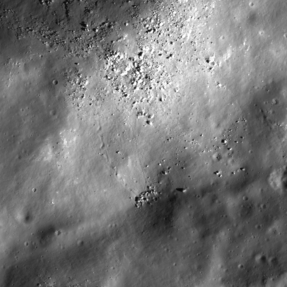
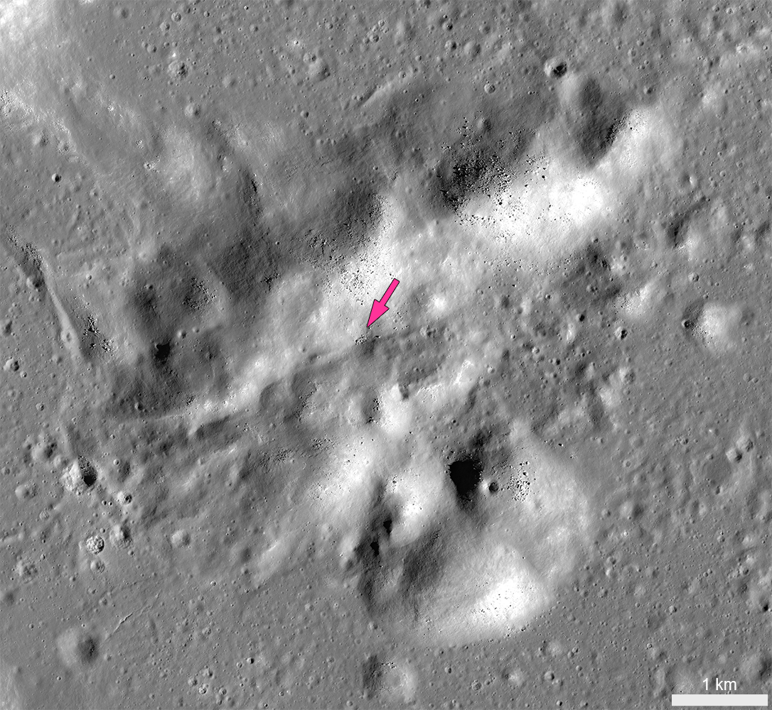
Boulders collect in a small depression right in the middle of the central peak cluster of Steno Q crater (20.063°N, 157.728°E) . Some of these boulders are as big as houses. Field of view 870 meters, portion of NAC controlled mosaic, illumination from the southeast [NASA/GSFC/Arizona State University].
J. Stopar
LROC News System

Steno Q is a 32 km diameter crater located in the highland terrain east of Mare Moscoviense. Impact craters, including Steno Q, are formed through a three-stage process consisting of: 1) contact and compression, 2) excavation, and 3) modification.

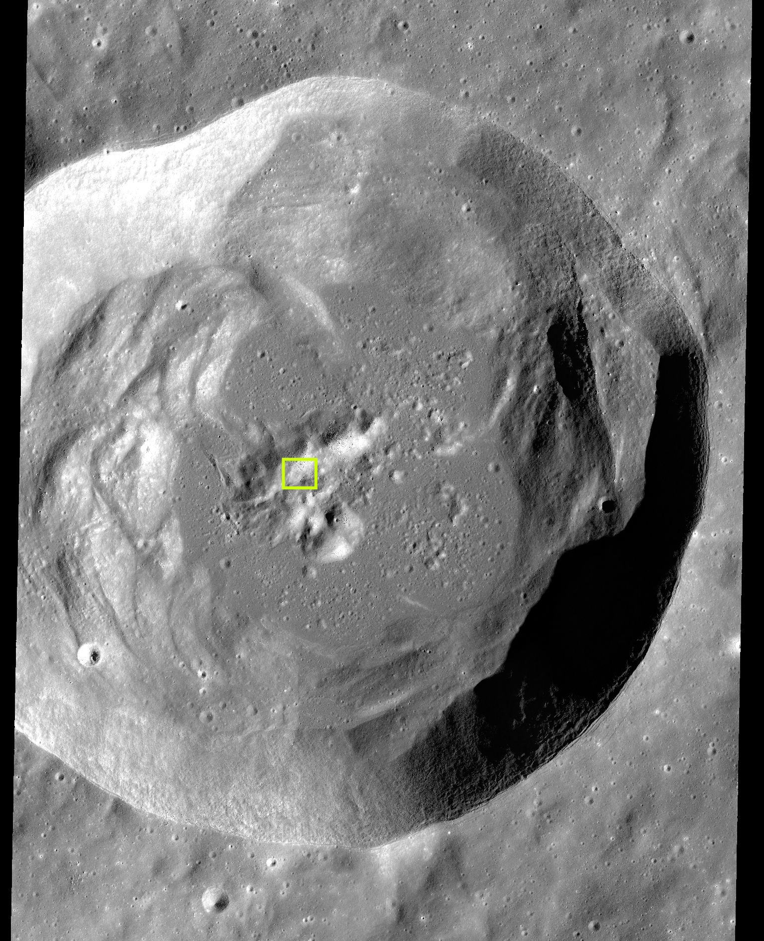
The initial crater cavity is formed during the excavation stage; during this stage, the excavated material is ejected from the crater, leaving a roughly bowl-shaped void. During modification, the last stage, the shape of the crater cavity adjusts as a function of planetary gravity and scale of impact. For larger impacts, a complex crater shape is formed as a result of a large degree of crater modification: the walls of complex craters slump through gravitational instability, a central peak forms through rebound, and impact melt and debris collect in the crater floor. Typical of other similarly sized Copernican age craters (those younger than 1 billion years), Steno Q preserves a central peak, steep walls with large slump blocks, and a sizeable pond of solidified impact melt rocks covering the lowest parts of the crater cavity.

Explore more complex craters around the Moon at the following LROC Featured Image posts: "Terraces in Eratosthenes Crater," "Not your average complex crater," "Impact melt features in Tycho craters floor," "Aitken Central Peak, Seen Obliquely," "Icarus," "Copernicus Central Peak From The West."

stenoQ_centralpeak-1086x1000
Central peak of Steno Q crater, with the location of the "Bowl of Boulders" shown at high-resolution in the LROC Featured Image indicated by the arrow [NASA/GSFC/Arizona State University].
Today's Featured Image closely examines part of the central peak of Steno Q, roughly 10 kilometers wide and consisting of mountains more than 2000 meters high.

The crests of several of these mountains are blocky and composed of highly stressed and fractured materials from the deepest part of the crater. Over time, boulders perched on these steep slopes can roll downhill as a result of seismic tremors and the shaking caused by nearby impacts. A small depression near the middle of the central peak preserves a collection of boulders accumulated from upslope.

Some of these boulders are more than 20m wide -- as big as a house. To get an idea of just how big that is, watch this video, HERE, of Apollo 16 astronauts Charles Duke and John Young approaching similarly-sized "House Rock," on the rim of North Ray crater.

Charlie Duke samples a shatter cone formation in "Outhouse Rock," a large fragment shed off the southern end of "House Rock," during the third and final EVA of Apollo 16 in 1972. Note the accumulation of lunar dust after totaling 20 hours on the lunar surface. (AS16-116-18649) [John Young/NASA/JSC/ALSJ].
At Steno Q, trails of the most recent boulder falls indicate the source of the material upslope. Boulder accumulations like this provide a unique opportunity for future explorers to collect a variety of materials derived from potentially inaccessible areas, like steep mountain peaks or the deepest components of the original surface excavated by the crater-forming impact.

stenoQ_context1-1535x1892
Complex crater Steno Q, (32 km, 29.063°N, 157.728°E). Typical of lunar craters of this size, Steno Q underwent extensive crater modification during the impact process, including wall slumping, central peak uplift and impact melt ponding. The box encompasses the field of view in the LROC Featured Image released December 12, 2013 [NASA/GSFC/Arizona State University].
The images in this post were derived from a 1.5 meter per pixel-scale LROC NAC controlled mosaic -- allowing users to explore the entire Steno Q crater, HERE.

Related LROC Posts:
Bouncing, Bounding Boulders!
Boulder trails in Menelaus crater
Rolling Rolling Rolling
Boulder Tales
Bounce, Roll, and Stop
Lazy Boulders in Scaliger Crater
A Recent Journey